Article

GCPs-Free Photogrammetry for Estimating Tree Height and Crown Diameter in Arizona Cypress Plantation Using UAV-Mounted GNSS RTK

by
Morteza Pourreza
1,2,*,
Fardin Moradi
2,
Mohammad Khosravi
1,2,
Azade Deljouei
3,* and
Melanie K. Vanderhoof
4
1
Department of Natural Resources, Faculty of Agriculture and Natural Resources, Razi University, Kermanshah 6714414971, Iran
2
Aerial Monitoring Research Group, Razi University, Kermanshah 6714414971, Iran
3
School of Forest, Fisheries and Geomatics Sciences, University of Florida, Gainesville, FL 32611, USA
4
U.S. Geological Survey, Geosciences and Environmental Change Science Center, Denver Federal Center, MS980, Denver, CO 80225, USA
*
Authors to whom correspondence should be addressed.
Forests 2022, 13(11), 1905; https://doi.org/10.3390/f13111905
Submission received: 1 October 2022 / Revised: 8 November 2022 / Accepted: 10 November 2022 / Published: 12 November 2022

Abstract

:
One of the main challenges of using unmanned aerial vehicles (UAVs) in forest data acquisition is the implementation of Ground Control Points (GCPs) as a mandatory step, which is sometimes impossible for inaccessible areas or within canopy closures. This study aimed to test the accuracy of a UAV-mounted GNSS RTK (real-time kinematic) system for calculating tree height and crown height without any GCPs. The study was conducted on a Cupressus arizonica (Greene., Arizona cypress) plantation on the Razi University Campus in Kermanshah, Iran. Arizona cypress is commonly planted as an ornamental tree. As it can tolerate harsh conditions, this species is highly appropriate for afforestation and reforestation projects. A total of 107 trees were subjected to field-measured dendrometric measurements (height and crown diameter). UAV data acquisition was performed at three altitudes of 25, 50, and 100 m using a local network RTK system (NRTK). The crown height model (CHM), derived from a digital surface model (DSM), was used to estimate tree height, and an inverse watershed segmentation (IWS) algorithm was used to estimate crown diameter. The results indicated that the means of tree height obtained from field measurements and UAV estimation were not significantly different, except for the mean values calculated at 100 m flight altitude. Additionally, the means of crown diameter reported from field measurements and UAV estimation at all flight altitudes were not statistically different. Root mean square error (RMSE < 11%) indicated a reliable estimation at all the flight altitudes for trees height and crown diameter. According to the findings of this study, it was concluded that UAV-RTK imagery can be considered a promising solution, but more work is needed before concluding its effectiveness in inaccessible areas.

1. Introduction

Close-range photogrammetry using unmanned aerial vehicle (UAV) platforms is an attractive technology to acquire accurate and timely information on target phenomena, such as trees [1,2,3]. UAV platforms can provide extremely high spatial resolution and low-cost data, along with high versatility, flexibility, and adaptability, making them one of the most useful and efficient platforms for obtaining remotely sensed data at a local scale [4,5]. Traditionally, AGB and carbon stock have been estimated by measuring common dendrometric parameters such as Diameter at Breast Height (DBH) and height of trees in permanent field plots, and then applying allometric equations [6,7,8,9,10]. However, this method is costly, time-consuming, and labor intensive and, therefore, only appropriate for small forest stands [11]. Alternatively, satellite-based remote sensing approaches can be effectively used to derive forest characteristics (e.g., canopy cover and above-ground biomass (AGB)) at a regional scale for a much lower cost and effort [12,13]. Landsat, for example, offers free open-access data and has provided a unique archive of continuous images with moderate resolution (30 m) since 1972. However, the moderate resolution of Landsat limits the accuracy of Landsat-based forest stand information [14,15].
The great potential of UAV platforms compared with satellites has motivated a wide range of UAV photogrammetry applications to monitor forest ecosystems and their structure [16]. Tree height and crown diameter are some of the most common variables obtained using UAV technology [17,18]. Tree height and crown diameter in forests are not only used in allometric equations to calculate AGB and carbon storage [19], but have also been used to assess a wide range of stand characteristics. For example, tree height has been used to calculate the volume of single trees and forest stands [20], to help explain variability in the hydrological cycle of forests [21,22], to evaluate site production capacity [23,24], and to determine the ability of a tree to acquire resources [25]. Additionally, crown size is a good indicator of stand density, stand competition, and stand survival [26,27,28].
While forest stand data can be directly measured in the field [29], processing UAV data first requires an approach to determine UAV-camera position with high accuracy. Recently, the combination of UAV photogrammetry with the structure from motion (SfM) technique is a well-established approach for generating high-resolution digital elevation models (DEMs), digital terrain models (DTMs), and other spatial models [30]. The SfM model has no proper scale unless spatial reference information is used. There are two approaches to solving this problem: 1) using ground control points (GCPs); and 2) global navigation satellite system (GNSS)-tagged imagery. Most of the common UAVs use a GNSS receiver to add positional information to the images during flight [31,32]. The accuracy of the typical single-frequency GNSS receivers on the UAVs is in the range of meters and may be insufficient for high precision studies. Recently, the use of UAV-mounted GNSS–real-time kinematic (GNSS RTK) receivers has increased, because they provide higher accuracy and require a lower number of GCPs. Although UAVs equipped with GNSS RTK are relatively expensive, they have become more affordable [30]. Real-time kinematic (RTK) and post-processing kinematic (PPK) technology using multi-frequency and multi-constellation GNSS provide higher accuracy (at the centimeter level) and have enabled the accurate measurement of the UAV camera position [31,33,34]. Some studies have tried to optimize the number and distribution of the GCPs to get more accurate data from the study areas [2,3,4].
Recent studies have been focused on minimizing or eliminating GCPs by increasing the availability of UAVs with onboard GNSS RTK. However, systematic and random elevation error remains a problem [30], requiring a small number of GCPs to reduce this source of error [30,35,36]. Alternatively, it has been shown that multiple flights with different flight altitudes and image acquisition axis can also significantly reduce random and systematic errors [30], so that UAV direct georeferencing technology without GCPs may provide an acceptable positional accuracy level [35]. In many forested areas, implementing GCPs is time-consuming and even impossible in inaccessible areas. However, little is known about using the UAV-mounted GNSS RTK system in the field of forest inventory to measure trees’ dendrometric characteristics. To address this knowledge gap, the main objective of this study was to test if the dendrometric characteristics of trees could be accurately calculated without relying on GCPs. In this effort, the accuracy of a UAV-Mounted GNSS RTK system for calculating tree height and crown diameter without including GCPs was tested.

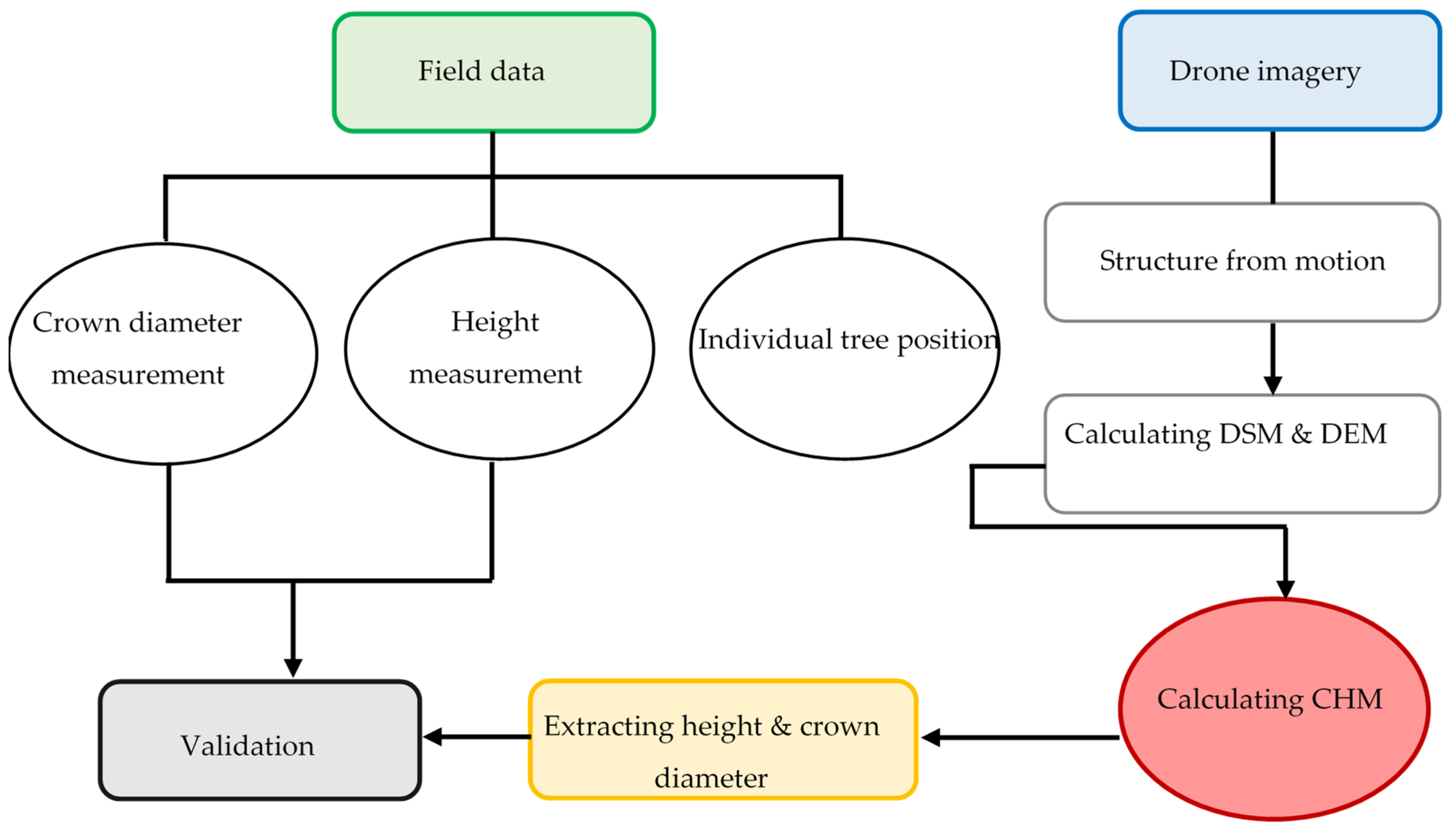
2. Materials and Methods

2.1. Study Area

This study was conducted on an even-aged stand (19 years old) of Arizona cypress (Cupressus arizonica Greene) trees, which is native to the south-western United States, on the campus of the Razi University located (Lat: 34°23′28″–34°23′28″; Long: 47°06′19″- 47°06′21″) in western Iran (Figure 1). This species is commonly planted as an ornamental tree, is well adapted to dry, harsh environments, has spread to vast areas of the world, and is highly appropriate for reforestation efforts [37,38,39]. It was introduced in 1954 for use in reforestation programs in semiarid regions of Iran [37,38,39,40]. The proposed methodology is not only applicable for monitoring these plantations in Iran but could also be used for forested areas all over the world. The plantation understory within our study area was comprised of sparse grasses. The study area was approximately 7 hectares, with an average slope of 10% and an average elevation of 1350 m above sea level.

2.2. UAV Data Acquisition

In this study, a Da-Jiang Innovations (DJI) Phantom 4 RTK quadcopter with a weight of 1391 g and dimensions of 35×35 cm was equipped with an RTK module for UAV data acquisition. Using a GNSS module, DJI Phantom 4 RTK is capable of receiving GPS (L1/L2), Galileo (E1/E5a), and Global Navigation Satellite System (GLONASS; L1/L2) satellites, providing a direct georeferencing of the images in real-time with centimeter-level positioning accuracy [41]. This drone is equipped with a 20-megapixel RGB camera, and a 1-inch complementary metal oxide semiconductor (CMOS) sensor. The lens has f/2.8–f/1.1 focal length and a focus range of 1 m–∞ with a viewing angle of 84° [41]. The RTK method was used to record location and geolocate the data, which uses the GNSS to provide accurate real-time positioning. In the RTK method, measurements are performed in two ways, including traditional RTK and network RTK (NRTK). The difference between the RTK and NRTK methods is that the NRTK method combines data from several reference stations to provide the rover with necessary corrections. However, in the traditional RTK method, the corrections obtained from the base station that are sent to the rover stations using radio modems which are limited to the power of their radio modems (distances within 5–10 km). In the NRTK system, distance-dependent errors between reference stations are interpolated without increasing position accuracy by increasing the distance between reference stations. For RTK mode, the DJI Phantom 4 RTK can be used together with the D-RTK 2 High Precision GNSS Mobile Station for direct georeferencing, or it can connect to the Internet to receive corrections using Network Transport of RTCM via Internet Protocol (NTRIP) technology via a 4G dongle or WiFi hotspot [41]. In this study, the SHAMIM system (Registry and Cadaster Office) was used as a network system with permanent reference stations. The flight with simple path planning (2D photogrammetry by using GS RTK software (version 2.02)) was comprised of 80% frontal and side overlap, and three flying heights above ground level: 25, 50, and 100 m (dated 10 August 2021). All flights were conducted on the same day, from 11:00 AM to 1:00 PM (local time), when the shadow of the ground phenomenon was the lowest. The UAV data acquisition was summarized in Table 1.

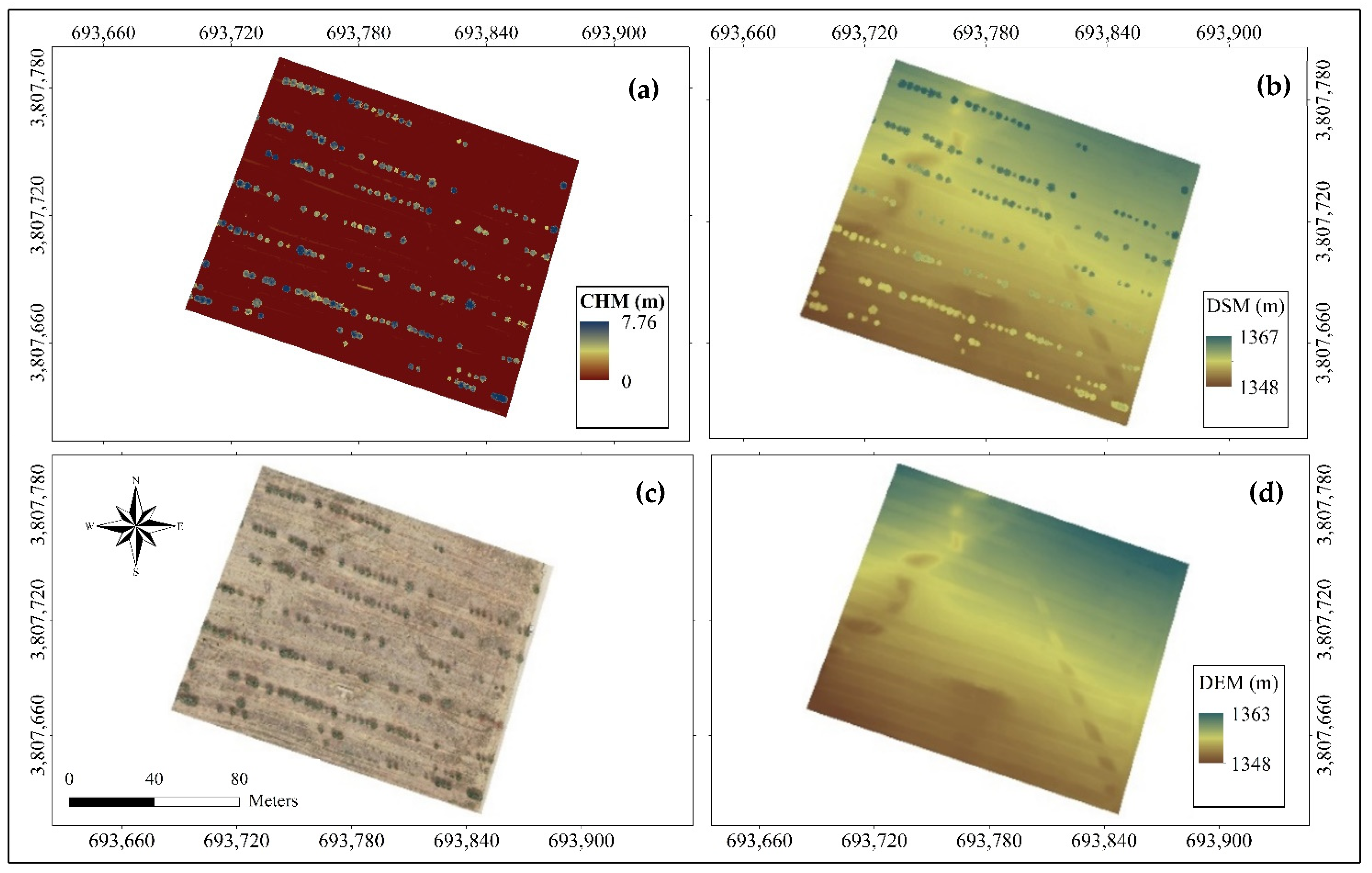
2.3. Generating DSM, DEM, CHM, and Orthomosaic

The required processes for estimating crown diameter and tree height from the UAV imagery were performed in Agisoft Metashape Professional v1.8.4 software. These processes included image alignment and generating (1) a dense point cloud, (2) DSM, (3) the digital elevation model (DEM), and (4) the orthomosaic, the parameters of which are shown in Table 2. Spatial resolution of DSM and DEM at flight altitudes of 25, 50, and 100 m were considered to be 3.06, 5.82, and 11.5 cm, respectively. In the next step, DEM and DSM were transferred to ArcGIS (Ver. 10.8) software, and a crown height model (CHM) was calculated as follows:
C H M = D S M D E M

2.4. Field Measurements

From 2 to 6 August 2021, tree height and crown diameter of 107 trees with natural growth form were measured indirectly using a Leica S910 Laser Distance Measurer (Heerbrugg, Switzerland), which is an instrument capable of measuring angles and distances by means of a laser beam and calculates tree heights based on the trigonometric principle. The Leica instrument led to errors when it was difficult to identify tree tops or when the tree was not perpendicular to the ground [42,43]. Leica S910 measure ranges between 0.5 and 300 m with an accuracy of 1 mm. It has different measuring modes, including an integrated calculator, area/volume calculations, Pythagoras, stake out, triangle area, delay timer, height tracking, indirect height, and profile measurement. Tree positions were recorded using the D-RTK2 handheld device.

2.5. Tree Height and Crown Diameter Estimation

To estimate the height of the trees using the UAV data, first, the spatial coordinates of each tree recorded by D-RTK2 were entered into ArcGIS (Ver. 10.8) software. The height of each tree was extracted and recorded from the CHM map using the Extract by mask function. The IWS (Inverse Watershed Segmentation) method was also used to estimate the crown diameter [44]. By using CHM, a suitable method of delineating tree crowns has been developed based on the IWS approach. For this purpose, CHM was inverted, transforming treetops into ponds and tree crowns into watersheds. Then, to create drainage basins, flow direction was applied to the inverted CHM. Using slope from trees’ crown to ponds, the flow direction calculates the direction water flows. Afterward, the basin tool was used to create a raster delineating drainage basins by identifying edge lines between basins. Since the resulting raster contained large gaps, the original CHM was used to create a Boolean raster mask (trees = 1, gaps = 0) by thresholding function. Finally, the average crown diameter of each tree was calculated by placing two axes perpendicular to each other on the crown and, using the Distance function, averaging the values.

2.6. Statistical Analysis

All the data, including tree plot and UAV, were tested for normal distribution and homogeneity of variances using the Kolmogorov–Smirnov and Leven’s tests, respectively. One-way ANOVA followed by Tukey’s test was used to compare the means of measured data and UAV photogrammetric estimated data at different flight altitudes. A simple linear regression model was used to find the relationship between field-based indirect measured data and the corresponding UAV photogrammetric estimated data. The coefficient of determination (R2) was calculated to assess the ability of the model to explain the outcome. Root mean square error percentage (RMSE%) and the mean absolute error (MAE) were calculated to evaluate the fitted model. Figure 2 illustrates a workflow of all methodology steps. IBM SPSS software (Ver. 23) was used for all the statistical analysis.

3. Results

The extracted DSM, DEM, and CHM of the UAV photogrammetry are shown in Figure 3. Minimum, maximum, and mean values of DEM were 1350.11, 1362.82, and 1355.93 m, with corresponding DSM values of 1350.11, 1367.00, and 1356.08 m. Similar values for CHM were 0, 7.76, and 0.16 m, respectively.

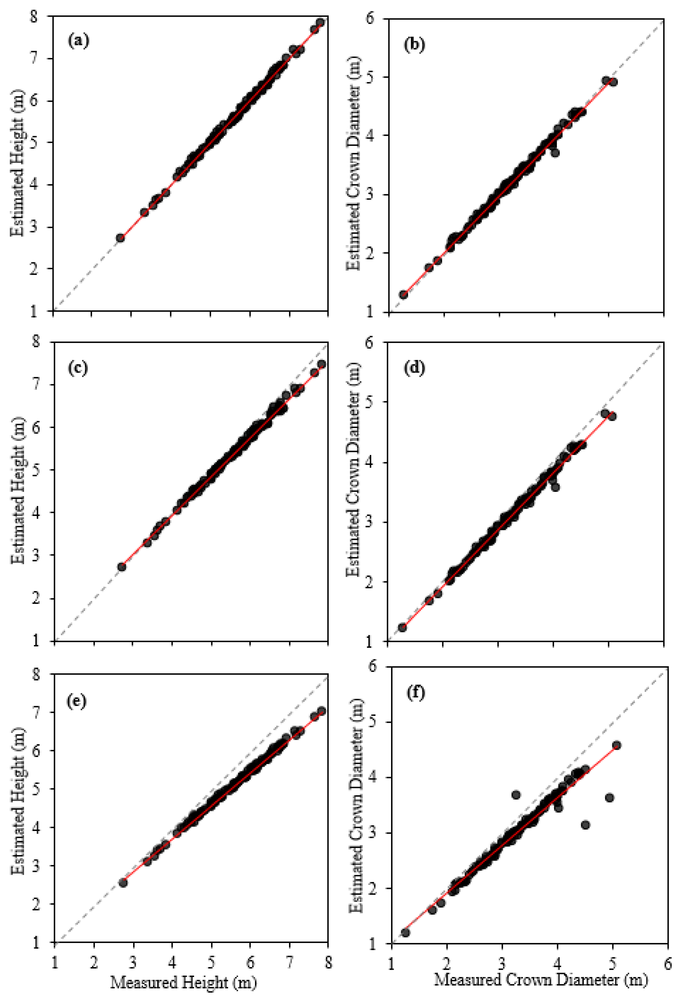
3.1. Comparison of the Measured and Estimated Variables

The mean, minimum, maximum and standard error of the field-measured and estimated trees height and crown diameter at flight altitudes of 25, 50, and 100 m are shown in Table 3. The results of the one-way ANOVA showed a significant difference (F = 7.46; p < 0.01) between the field-measured and estimated tree height data. In fact, the mean value of the estimated tree height at 100 m flight altitude was significantly lower than the mean values of measured and estimated tree height at 25 m and 50 m flight altitudes (Table 3). However, no significant difference (F = 3.19; p < 0.01) was observed between the field-measured and UAV-estimated trees crown diameter (Table 3).

3.2. Relationship between the Measured and Estimated Variables

The results of the linear regression model indicated indicate positive and strong relationship between the measured and estimated tree heights (R2 > 0.99) at all three flight altitudes. Similarly, the estimated crown diameters at 25 and 50 m flight altitudes showed a positive linear relationship between the measured values (R2 > 0.99) (Figure 4). A similar relationship was also observed between the measured height and estimated crown diameters at the 100 m flight altitude with a relatively lower coefficient of determination (R2 = 0.94). The RMSE for estimated tree heights at flight altitudes of 25, 50, and 100 m were 0.89%, 4.26%, and 10.21%, respectively. The MAE of the estimated tree heights was 0.04, 0.21, and 0.52 at flight altitudes of 25, 50, and 100 m, respectively (Table 4). The RMSE for estimated tree crown diameter at the same flight altitudes was found to be 2.18%, 4.58%, and 10.69%, respectively. Additionally, the MAE of the estimated tree crowns at flight altitudes of 25, 50, and 100 m were 0.05, 0.13, and 0.27, respectively. The estimations were negatively biased for both tree height and crown diameter. The bias of estimations increased as UAV flight altitude increased (Table 4). The regression line was located below the best fit (i.e., 1:1 line) for most scenarios (except Figure 4a), which means that the UAV underestimated tree height (Figure 4c,e) from −0.02 m at 25 m altitude to −0.52 m at 100 m altitude (Table 4) and crown diameter (Figure 4b,d,f) from −0.05 m at 25 m altitude to −0.27 m at 100 m altitude (Table 4). Overall, however, the UAV provided a regression line close to line of best fit across different flight altitudes (Figure 4).

4. Discussion

The first step in sustainable forest management is to obtain accurate and reliable information [45,46]. Tree height and crown diameter are key characteristics that are used in estimating above-ground biomass and forest structure [47,48]. UAV data acquisition for forest inventory has been attracting increased attention in recent years, as field data collection is an expensive and time-consuming process. However, one of the main challenges of using UAVs in forest environments is that, while the placement of GCPs is typically seen as technically mandatory, this step can be difficult or impossible in areas with canopy closure or that are inaccessible [49]. In contrast, RTK-enabled UAVs can provide higher accuracy with fewer GCPs or even with no GCPs [50]. In this study, a UAV-RTK system was used to eliminate the need for GCPs from the workflow for tree height and crown diameter calculation.
The results showed that RTK provides a promising solution for reducing the dependence on GCPs for estimating forest structure and tree dendrometeric characteristics in flat terrain. Comparing the estimated means of trees height at different flight altitudes indicated that in the analysis, the precision of the collected data by the UAV-RTK system was negatively dependent on the flight altitude. In other words, by increasing the flight altitude to 100 m, the precision of the estimated tree height decreases. Previous studies have similarly shown that the UAV flight altitude determines the spatial resolution of the image, and coverage area [51,52,53,54]. In addition, while the analysis tested RTK only, using GCPs can also show variable accuracy. For example, Birdal et al. [47] showed that there was no significant difference between the means of the field-measured trees height and estimated trees height using UAV imagery with RGB sensor for 125 m flight altitude. However, they used six three-dimensional (3D) GCPs, obtained with a Global Navigation Satellite System (GNSS) with the RTK technique for 15 ha, which took approximately 1 h in a flat area. In contrast, another study [44], which used four GCPs under leaf-on and leaf-off conditions to determine tree height in a deciduous forest, found a significant difference between the means of measured tree height and estimated trees height using UAV for a 100 m flight altitude. The findings of Taddia et al. [34] showed that the best results were obtained when a single signalized point per façade was used as a GCP for surveying and modeling a building using a DJI-P4RTK drone.
Literature reviews [30,44,55] have shown that the accuracy of tree measurements decreases with increasing flight altitude. The results of this study similarly indicated that the accuracy of the estimated trees height was negatively dependent on the flight altitude at altitudes greater than 25 m. However, the calculated RMSE = 0.89%, 4.26%, and 10.4%, respectively, for different flight altitudes (25, 50, and 100 m) suggest a reliable accuracy for all the flight altitudes. In comparison, the calculated RMSE (%) for estimated tree height in the study of Nasiri et al. [44] with four GCPs under leaf-on and leaf-off conditions, was 10.1%, which is very close to the results obtained in this study with no GCPs. Similarly, Lim et al. [48] calculated tree height using segmentation and no GCPs with a RMSE = 0.84 m (4.7%) and 2.45 m (7.6%) for 45 and 55 m flight altitudes, respectively, a finding which is comparable with the results for a flight altitude of 50 m (RMSE = 4.26%). The findings of Pachehkenari and Fadaei [56] for estimating tree height without the need to include GCPs demonstrated that the smart integration of key parameters in flight design can decrease RMSE. However, using GCPs with an appropriate distribution resulted in 36% better performance [57]. Their study highlighted that when local GCP is inaccessible, considering an optimal distribution in GCP and the strategy of using images extracted from flight strips with different altitudes help to increase the accuracy of extracted data. A recent study using a UAV-mounted RTK system and direct georeferencing in an urban area indicated a high accuracy of vertical measurement (RMSE = 0.087 m), suggesting that this system can provide an acceptable level of height accuracy without using GCPs [35].
The finding of this study that the tree crown diameter exhibits no significant differences between the mean values of measured and estimated data suggests the high precision of the data even at a flight altitude of 100 m, obtained from UAV imagery with the RTK system. Similarly, the finding of Nasiri et al. [44] for estimating trees crown diameter using four GCPs under leaf-on and leaf-off conditions indicated no significant difference between the means of measured and estimated data for a flight altitude of 100 m. The findings indicate that, similar to tree height, the accuracy of the estimated average tree crown diameter is also negatively dependent on flight altitude. It is worth noting that the accuracy of the estimated tree heights is highly dependent on the flight altitude, not the NRTK system used [30], because the same NRTK system (SHAMIM) was used for all the flight altitudes. According to previous studies, the resolution of DEM and DSM is dependent upon the flight altitude, which can eventually influence the accuracy of the estimated trees height [55]. In this regard, the results of Štroner et al. [30] (using UAV-mounted GNSS RTK without GCPs) demonstrated that the elevation error from individual flights yielded systematic elevation errors (up to several decimeters) and indicated that the error was linearly dependent upon the deviation of the focal length from the reference value. They proposed that a combination of two flights with different image acquisition axes (nadiral and oblique) can be considered as an appropriate solution to eliminate this systematic error.
One of the goals of this study was to find an appropriate flight altitude with acceptable accuracy to limit image processing time requirements. At higher flight altitudes, the smaller number of recorded images can be expected to reduce the time needed for image processing. Although finding an optimal flight altitude depends on many parameters, comparing the number of recorded images for the flight altitudes of 25 and 100 m (529 and 84 images, respectively), the findings indicated that using a flight altitude of 100 m and 84 images can yield acceptable accuracy with the benefit of limited field work (no GCPs process) and less image processing time. The calculated RMSE for different flight altitudes (25, 50, and 100 m) were 2.18%, 4.58%, and 10.69%, respectively, suggesting excellent to good accuracy and reliable estimation for all the flight altitudes. If improved accuracy was required, then employing either a lower flight altitude or combining data from multiple flights [30] may be required.
Estimating AGB using nondestructive methods, such as remote sensing, requires accurate measurements of individual trees dendrometric characteristics, including tree height and crown diameter [57,58]. Therefore, the accuracy of the measured data plays a key role in estimating accurate AGB and carbon stock of individual trees in forest stands. The results of this study indicated relatively accurate data of tree heights and crown diameter can be obtained using a direct georeferencing method without the need for GCPs. Liu et al. [35] indicated that the photogrammetry using a UAV-mounted RTK system and direct georeferencing (without using GCPs) provides a very low RMSE and an acceptable positioning accuracy level. This study was conducted in an open-canopy forest over a relatively flat area (average slope = 10%). The question that may be raised here regards how accurate the measured data would be in steep areas with dense canopy. A DEM-based flight plan would be a good solution for steep areas as DEMs provide key information about slope and altitude. However, further studies need to be conducted to address these questions, especially in complex terrain. To this end, Stott et al. [59] reported that an RTK-GNSS UAV can be employed even with no GCPs to provide acceptable results of vertical measurement (z-axis) for kilometer-scale topographic mapping. The results of Tomaštík et al. [32] suggest that the RTK/PPK method using no GCPs could provide an optimal solution for mapping inaccessible and hazardous forested areas with acceptable vertical and horizontal accuracy.
Considering the bias estimation, the findings of this study indicated an underestimation of tree height and crown diameter, which increased with increasing UAV flight altitude. Previous studies have similarly reported an underestimation in UAV-derived tree height compared to the field measurement [1,5,60]. Johansen et al. [60] showed that underestimation of tree crown height was positively correlated with increasing flying height (30, 50, and 70 m); however, the estimation value of tree crown width was not affected by different flight altitudes. It is worth mentioning that besides the effect of flight altitude, the underestimation of measurements tended to increase with tree size (Figure 4), suggesting higher measurement accuracies for smaller trees. The sources of the bias estimation of tree height and crown diameter might be associated with (i) the possible overestimation of indirect field measurement and (ii) underestimation because of the smoothing effect of the CHM derived by UAV photogrammetry [1,48].

5. Conclusions

This study investigated the capability of a Phantom 4 equipped with an RTK positioning system for eliminating ground control points to estimate the height and crown diameter of Arizona cypress in flat terrain, a tree species that is highly appropriate for reforestation efforts across the region. The results showed that the average estimated tree height at a flight altitude of 100 m was 5.12 m, which was statistically lower than the field-measured value of tree height (5.63 m) and tree height as estimated at a flight altitude of 25 m (5.61 m); however, estimated and measured crown diameter were not significantly different. The results showed a positive and strong relationship between the measured and estimated tree heights and crown diameters (R2 > 0.99) at all three flight altitudes. The RMSE for estimated tree heights at flight altitudes of 25, 50, and 100 m were 0.9%, 4.3%, and 10.2%, respectively and the same values for the MAE were 0.04, 0.21, and 0.52, respectively. The RMSE for estimated tree crown diameter at flight altitudes of 25, 50, and 100 m were found to be 2.2%, 4.6%, and 10.7%, respectively. Additionally, the MAE of the estimated tree crown at the same flight altitudes were 0.05, 0.13, and 0.27, respectively. Additionally, the findings indicated an underestimation both for tree height and crown diameter, which increased with increasing the UAV flight altitude and tended to increase with tree size. The results showed that despite the significant difference between the parameters estimated at the altitude of 100 m and the parameters measured by the Leica laser meter, the obtained model had a RMSE of about 10%, which indicates the model’s good performance. It is challenging to implement ground control points over large or inaccessible areas, or where the forest canopy is dense, so UAV data processing approaches that can accurately estimate tree characteristics without GCP’s will provide an advantage. Furthermore, a higher flight altitude will shorten the flight time, reduce the number of images, and corresponding data processing. Therefore, it was concluded that this drone can estimate the height and crown diameter of trees with acceptable accuracy at flight altitudes of up to 100 m without ground control points in open canopies on relatively flat terrain. On the other hand, further studies need to be conducted in complex landscapes with dense and closed forest canopies.

Author Contributions

Conceptualization, M.P. and F.M.; Methodology, M.P. and F.M.; software, F.M. and A.D.; validation, M.P., F.M. and A.D.; resources, M.K.; data curation, M.P., F.M. and A.D.; writing—original draft preparation, M.P. and F.M. and A.D.; writing—review and editing, M.K.V.; supervision. All authors have read and agreed to the published version of the manuscript.

Funding

This research received no external funding.

Data Availability Statement

Those interested in obtaining the data that support our results may contact the first author (M.P.).

Acknowledgments

Any use of trade, product, or firm names is for descriptive purposes only and does not imply endorsement by the U.S. Government.

Conflicts of Interest

The authors declare no conflict of interest.

Abbreviations

AGBAbove-Ground Biomass
CHMCrown Height Model
DBHDiameter at Breast Height
DEMDigital Elevation Model
DJIDa-Jiang Innovations
DSMDigital Surface Model
GCPGround Control Point
GLONASSGlobalnaya Navigazionnaya Sputnikovaya Sistema
GNSSGlobal Navigation Satellite System
IWSInverse Watershed Segmentation
RTKReal-Time Kinematic
MAEMean absolute error
NRTKNetwork Real-Time Kinematic
NTRIPNetwork Transport of RTCM via Internet Protocol
PPKPost-Processing Kinematic
RMSERoot Mean Square Error
SfMStructure from Motion
UAVUnmanned Aerial Vehicle

References

  1. Krause, S.; Sanders, T.G.M.; Mund, J.-P.; Greve, K. UAV-Based Photogrammetric Tree Height Measurement for Intensive Forest Monitoring. Remote Sens. 2019, 11, 758. [Google Scholar] [CrossRef] [Green Version]
  2. Zhang, K.; Okazawa, H.; Hayashi, K.; Hayashi, T.; Fiwa, L.; Maskey, S. Optimization of ground control point distribution for unmanned aerial vehicle photogrammetry for inaccessible fields. Sustainability 2022, 14, 9505. [Google Scholar] [CrossRef]
  3. Yang, J.; Li, X.; Luo, L.; Zhao, L.; Wei, J.; Ma, T. New Supplementary Photography Methods after the Anomalous of Ground Control Points in UAV Structure-from-Motion Photogrammetry. Drones 2022, 6, 105. [Google Scholar] [CrossRef]
  4. Ferrer-González, E.; Agüera-Vega, F.; Carvajal-Ramírez, F.; Martínez-Carricondo, P. UAV photogrammetry accuracy assessment for corridor mapping based on the number and distribution of ground control points. Remote Sens. 2020, 12, 2447. [Google Scholar] [CrossRef]
  5. Hentz, A.M.K.; Silva, A.; Dalla Corte, A.P.; Netto, P.; Strager, M.P.; Klauberg, C. Estimating forest uniformity in Eucalyptus spp and Pinus taeda L stands using field measurements and structure from motion point clouds generated from unmanned aerial vehicle (UAV) data collection. For. Syst. 2018, 27, 17. [Google Scholar] [CrossRef]
  6. Anderson-Teixeira, K.J.; Davies, S.J.; Bennett, A.C.; Gonzalez-Akre, E.B.; Muller-Landau, H.C.; Joseph Wright, S.; Abu Salim, K.; Almeyda Zambrano, A.M.; Alonso, A.; Baltzer, J.L. CTFS-Forest GEO: A worldwide network monitoring forests in an era of global change. Glob. Chang. Biol. 2015, 21, 528–549. [Google Scholar] [CrossRef] [PubMed] [Green Version]
  7. Moradi, F.; Sadeghi, S.M.M.; Heidarlou, H.B.; Deljouei, A.; Boshkar, E.; Borz, S.A. Above-ground biomass estimation in a Mediterranean sparse coppice oak forest using Sentinel-2 data. Ann. For. Res. 2022, 65, 165–182. [Google Scholar] [CrossRef]
  8. Pan, Y.; Birdsey, R.A.; Fang, J.; Houghton, R.; Kauppi, P.E.; Kurz, W.A.; Phillips, O.L.; Shvidenko, A.; Lewis, S.L.; Canadell, J.G. A large and persistent carbon sink in the world’s forests. Science 2011, 333, 988–993. [Google Scholar] [CrossRef] [Green Version]
  9. Velázquez-Martí, B.; Gaibor-Chávez, J.; Pérez-Pacheco, S. Quantification based on dimensionless dendrometry and drying of residual biomass from the pruning of orange trees in Bolivar province (Ecuador). Biofuels Bioprod. Biorefin. 2016, 10, 175–185. [Google Scholar] [CrossRef]
  10. Ganz, S.; Käber, Y.; Adler, P. Measuring Tree Height with Remote Sensing—A Comparison of Photogrammetric and LiDAR Data with Different Field Measurements. Forests 2019, 10, 694. [Google Scholar] [CrossRef]
  11. Brack, D. Combating illegal Logging: Interaction with WTO Rules; Chatham House: London, UK, 2009. [Google Scholar]
  12. Goetz, S.; Dubayah, R. Advances in remote sensing technology and implications for measuring and monitoring forest carbon stocks and change. Carbon Manag. 2011, 2, 231–244. [Google Scholar] [CrossRef]
  13. Moradi, F.; Darvishsefat, A.A.; Namiranian, M.; Ronoud, G. Investigating the capability of Landsat 8 OLI data for estimation of aboveground woody biomass of common hornbeam (Carpinus betulus L.) stands in Khyroud Forest. Iran. J. For. Poplar Res. 2018, 26, 406–420. [Google Scholar]
  14. Main-Knorn, M.; Cohen, W.B.; Kennedy, R.E.; Grodzki, W.; Pflugmacher, D.; Griffiths, P.; Hostert, P. Monitoring coniferous forest biomass change using a Landsat trajectory-based approach. Remote Sens. Environ. 2013, 139, 277–290. [Google Scholar] [CrossRef]
  15. Nguyen, T.H.; Jones, S.D.; Soto-Berelov, M.; Haywood, A.; Hislop, S. Monitoring aboveground forest biomass dynamics over three decades using Landsat time-series and single-date inventory data. Int. J. Appl. Earth Obs. Geoinf. 2020, 84, 101952. [Google Scholar] [CrossRef]
  16. Ren, H.; Zhao, Y.; Xiao, W.; Hu, Z. A review of UAV monitoring in mining areas: Current status and future perspectives. Int. J. Coal Sci. Technol. 2019, 6, 320–333. [Google Scholar] [CrossRef] [Green Version]
  17. Jaunky, V.C.; Lundmark, R. Dynamics of Timber Market Integration in Sweden. Forests 2015, 6, 4617–4633. [Google Scholar] [CrossRef]
  18. Zarco-Tejada, P.J.; Diaz-Varela, R.; Angileri, V.; Loudjani, P. Tree height quantification using very high resolution imagery acquired from an unmanned aerial vehicle (UAV) and automatic 3D photo-reconstruction methods. Eur. J. Agron. 2014, 55, 89–99. [Google Scholar] [CrossRef]
  19. Wang, Y.; Zhang, X.; Guo, Z. Estimation of tree height and aboveground biomass of coniferous forests in North China using stereo ZY-3, multispectral Sentinel-2, and DEM data. Ecol. Indic. 2021, 126, 107645. [Google Scholar] [CrossRef]
  20. Kershaw, J.A., Jr.; Ducey, M.J.; Beers, T.W.; Husch, B. Forest Mensuration; John Wiley & Sons: Chichester, UK, 2016. [Google Scholar]
  21. Hakimi, L.; Sadeghi, S.M.M.; Van Stan, J.T.; Pypker, T.G.; Khosropour, E. Management of pomegranate (Punica granatum) orchards alters the supply and pathway of rain water reaching soils in an arid agricultural landscape. Agric. Ecosyst. Environ. 2018, 259, 77–85. [Google Scholar] [CrossRef]
  22. Sadeghi, S.M.M.; Attarod, P.; Pypker, T.G. Differences in Rainfall Interception during the Growing and Non-growing Seasons in a Fraxinus rotundifolia Mill. Plantation Located in a Semiarid Climate. J. Agric. Sci. Tech. 2015, 17, 145–156. [Google Scholar]
  23. Shao, G.; Shugart, H.; Smith, T. A role-type model (rope) and its application in assessing climate change impacts on forest landscapes. In Global Change and Terrestrial Ecosystems in Monsoon Asia; Springer: Berlin/Heidelberg, Germany, 1995; pp. 135–146. [Google Scholar]
  24. West, P.W. Tree and Forest Measurement; Springer: Berlin/Heidelberg, Germany, 2015. [Google Scholar]
  25. Thenkabail, P.S. Land Resources Monitoring, Modeling, and Mapping with Remote Sensing; CRC Press Inc.: Boca Raton, FL, USA, 2015. [Google Scholar]
  26. Gao, H.; Bi, H.; Li, F. Modelling conifer crown profiles as nonlinear conditional quantiles: An example with planted Korean pine in northeast China. For. Ecol. Manag. 2017, 398, 101–115. [Google Scholar] [CrossRef]
  27. Sefidi, K.; Copenheaver, C.A.; Sadeghi, S.M.M. Anthropogenic pressures decrease structural complexity in Caucasian forests of Iran. Écoscience 2022, 29, 199–209. [Google Scholar] [CrossRef]
  28. Valjarević, A.; Djekić, T.; Stevanović, V.; Ivanović, R.; Jandziković, B. GIS numerical and remote sensing analyses of forest changes in the Toplica region for the period of 1953–2013. Appl. Geogr. 2018, 92, 131–139. [Google Scholar] [CrossRef]
  29. Shen, W.; Li, M.; Huang, C.; Tao, X.; Wei, A. Annual forest aboveground biomass changes mapped using ICESat/GLAS measurements, historical inventory data, and time-series optical and radar imagery for Guangdong province, China. Agric. For. Meteorol. 2018, 259, 23–38. [Google Scholar] [CrossRef] [Green Version]
  30. Štroner, M.; Urban, R.; Seidl, J.; Reindl, T.; Brouček, J. Photogrammetry Using UAV-Mounted GNSS RTK: Georeferencing Strategies without GCPs. Remote Sens. 2021, 13, 1336. [Google Scholar] [CrossRef]
  31. Eker, R.; Alkan, E.; Aydin, A. Accuracy Comparison of UAV-RTK and UAV-PPK Methods in Mapping Different Surface Types. Eur. J. For. Eng. 2021, 7, 12–25. [Google Scholar] [CrossRef]
  32. Tomaštík, J.; Mokroš, M.; Surový, P.; Grznárová, A.; Merganič, J. UAV RTK/PPK Method—An Optimal Solution for Mapping Inaccessible Forested Areas? Remote Sens. 2019, 11, 721. [Google Scholar] [CrossRef] [Green Version]
  33. Rehak, M.; Mabillard, R.; Skaloud, J. A Micro-UAV with the Capability of Direct Georeferencing; ISPRS Archives: Freiburg, Germany, 2013. [Google Scholar]
  34. Taddia, Y.; González-García, L.; Zambello, E.; Pellegrinelli, A. Quality Assessment of Photogrammetric Models for Façade and Building Reconstruction Using DJI Phantom 4 RTK. Remote Sens. 2020, 12, 3144. [Google Scholar] [CrossRef]
  35. Liu, X.; Lian, X.; Yang, W.; Wang, F.; Han, Y.; Zhang, Y. Accuracy Assessment of a UAV Direct Georeferencing Method and Impact of the Configuration of Ground Control Points. Drones 2022, 6, 30. [Google Scholar] [CrossRef]
  36. Van Le, C.; Cao, C.X.; Le, H.T.T. Research on optimal takeoff positions of UAV integrated GNSS-RTK in producing large scale topological maps for open-pit mines. J. Min. Earth Sci. 2020, 61, 54–63. [Google Scholar]
  37. Sadeghi, S.M.M.; Attarod, P.; Pypker, T.G.; Dunkerley, D. Is canopy interception increased in semiarid tree plantations? Evidence from a field investigation in Tehran, Iran. Turk. J. Agric. For. 2014, 38, 792–806. [Google Scholar] [CrossRef]
  38. Sadeghi, S.M.M.; Attarod, P.; Van Stan II, J.T.; Pypker, T.G.; Dunkerley, D. Efficiency of the reformulated Gash’s interception model in semiarid afforestations. Agric. For. Meteorol. 2015, 201, 76–85. [Google Scholar] [CrossRef]
  39. Sadeghi, S.M.M.; Attarod, P.; Van Stan, J.T.; Pypker, T.G. The importance of considering rainfall partitioning in afforestation initiatives in semiarid climates: A comparison of common planted tree species in Tehran, Iran. Sci. Total Environ. 2016, 568, 845–855. [Google Scholar] [CrossRef] [PubMed]
  40. Attarod, P.; Sadeghi, S.M.M.; Pypker, T.G.; Bagheri, H.; Bagheri, M.; Bayramzadeh, V. Needle-leaved trees impacts on rainfall interception and canopy storage capacity in an arid environment. New For. 2015, 46, 339–355. [Google Scholar] [CrossRef]
  41. Eker, R.; Alkan, E.; Aydin, A. A comparative analysis of UAV-RTK and UAV-PPK methods in mapping different surface types. Eur. J. For. Eng. 2020, 7, 12–25. [Google Scholar]
  42. Dassot, M.; Constant, T.; Fournier, M. The use of terrestrial LiDAR technology in forest science: Application fields, benefits and challenges. Ann. For. Sci. 2011, 68, 959–974. [Google Scholar] [CrossRef] [Green Version]
  43. Hopkinson, C.; Chasmer, L.; Young-Pow, C.; Treitz, P. Assessing forest metrics with a ground-based scanning lidar. Can. J. For. Res. 2004, 34, 573–583. [Google Scholar] [CrossRef] [Green Version]
  44. Nasiri, V.; Darvishsefat, A.A.; Arefi, H.; Pierrot-Deseilligny, M.; Namiranian, M.; Le Bris, A. Unmanned aerial vehicles (UAV)-based canopy height modeling under leaf-on and leaf-off conditions for determining tree height and crown diameter (case study: Hyrcanian mixed forest). Can. J. For. Res. 2021, 51, 962–971. [Google Scholar] [CrossRef]
  45. Franklin, S.E. Remote Sensing for Sustainable Forest Management; CRC Press: Boca Raton, FL, USA, 2001. [Google Scholar]
  46. Farahnak, M.; Mitsuyasu, K.; Jeong, S.; Otsuki, K.; Chiwa, M.; Sadeghi, S.M.M.; Kume, A. Soil hydraulic conductivity differences between upslope and downslope of two coniferous trees on a hillslope. J. For. Res. 2019, 24, 143–152. [Google Scholar] [CrossRef]
  47. Birdal, A.C.; Avdan, U.; Türk, T. Estimating tree heights with images from an unmanned aerial vehicle. Geomat. Nat. Hazards Risk 2017, 8, 1144–1156. [Google Scholar] [CrossRef] [Green Version]
  48. Lim, Y.S.; La, P.H.; Park, J.S.; Lee, M.H.; Pyeon, M.W.; Kim, J.-I. Calculation of Tree Height and Canopy Crown from Drone Images Using Segmentation. J. Korean Soc. Surv. Geod. Photogramm. Cartogr. 2015, 33, 605–614. [Google Scholar] [CrossRef] [Green Version]
  49. Jaud, M.; Bertin, S.; Beauverger, M.; Augereau, E.; Delacourt, C. RTK GNSS-Assisted Terrestrial SfM Photogrammetry without GCP: Application to Coastal Morphodynamics Monitoring. Remote Sens. 2020, 12, 1889. [Google Scholar] [CrossRef]
  50. Ekaso, D.; Nex, F.; Kerle, N. Accuracy assessment of real-time kinematics (RTK) measurements on unmanned aerial vehicles (UAV) for direct geo-referencing. Geo-Spat. Inf. Sci. 2020, 23, 165–181. [Google Scholar] [CrossRef] [Green Version]
  51. Anders, N.; Smith, M.; Suomalainen, J.; Cammeraat, E.; Valente, J.; Keesstra, S. Impact of flight altitude and cover orientation on Digital Surface Model (DSM) accuracy for flood damage assessment in Murcia (Spain) using a fixed-wing UAV. Earth Sci. Inform. 2020, 13, 391–404. [Google Scholar] [CrossRef]
  52. Flores-de-Santiago, F.; Valderrama-Landeros, L.; Rodríguez-Sobreyra, R.; Flores-Verdugo, F. Assessing the effect of flight altitude and overlap on orthoimage generation for UAV estimates of coastal wetlands. J. Coast. Conserv. 2020, 24, 35. [Google Scholar] [CrossRef]
  53. Mesas-Carrascosa, F.-J.; Torres-Sánchez, J.; Clavero-Rumbao, I.; García-Ferrer, A.; Peña, J.-M.; Borra-Serrano, I.; López-Granados, F. Assessing Optimal Flight Parameters for Generating Accurate Multispectral Orthomosaicks by UAV to Support Site-Specific Crop Management. Remote Sens. 2015, 7, 12793–12814. [Google Scholar] [CrossRef] [Green Version]
  54. Mesas-Carrascosa, F.J.; Notario Garcia, M.D.; Merono de Larriva, J.E.; Garcia-Ferrer, A. An Analysis of the Influence of Flight Parameters in the Generation of Unmanned Aerial Vehicle (UAV) Orthomosaicks to Survey Archaeological Areas. Sensors 2016, 16, 1838. [Google Scholar] [CrossRef] [PubMed] [Green Version]
  55. Doumit, J. Multiscale Landforms Classification Based on UAV Datasets. Sustain. Env. 2018, 3, 128. [Google Scholar] [CrossRef] [Green Version]
  56. Pachehkenari, M.S.; Fadaei, H. Assessing the Accuracy of Tree Height Quantification Models Derived from Unmanned Aerial System Imagery. Am. J. Geogr. Inf. Syst. 2020, 9, 55–63. [Google Scholar]
  57. Wang, M.; Sun, R.; Xiao, Z. Estimation of Forest Canopy Height and Aboveground Biomass from Spaceborne LiDAR and Landsat Imageries in Maryland. Remote Sens. 2018, 10, 344. [Google Scholar] [CrossRef] [Green Version]
  58. Fernández-Sarría, A.; López-Cortés, I.; Estornell, J.; Velázquez-Martí, B.; Salazar, D. Estimating residual biomass of olive tree crops using terrestrial laser scanning. Int. J. Appl. Earth Obs. Geoinf. 2019, 75, 163–170. [Google Scholar] [CrossRef]
  59. Stott, E.; Williams, R.D.; Hoey, T.B. Ground Control Point Distribution for Accurate Kilometre-Scale Topographic Mapping Using an RTK-GNSS Unmanned Aerial Vehicle and SfM Photogrammetry. Drones 2020, 4, 55. [Google Scholar] [CrossRef]
  60. Johansen, K.; Raharjo, T.; McCabe, M.F. Using Multi-Spectral UAV Imagery to Extract Tree Crop Structural Properties and Assess Pruning Effects. Remote Sens. 2018, 10, 854. [Google Scholar] [CrossRef]
Figure 1. Location of the study area in Kermanshah province (western Iran) and photo of the study area with routes of drone at different altitudes of 25, 50, and 100 m.
Forests 13 01905 g001
Figure 2. A flow chart to illustrate the analysis and outputs.
Forests 13 01905 g002
Figure 3. Generated (a) crown height model (CHM), (b) digital surface model (DSM), (c) orthomosaic, and (d) digital elevation model (DEM).
Forests 13 01905 g003
Figure 4. The relationship between the measured and estimated tree height at various flight altitudes: (a) 25 m, (c) 50 m, (e) 100 m, and measured and estimated crown diameter at various flight altitudes: (b) 25 m, (d) 50 m, (f) 100 m. The 1:1 line is shown as a grey dashed line in all panels.
Forests 13 01905 g004
Table 1. Summary of unmanned aerial vehicle (UAV) data acquisition.
AttributeFlying Altitude (m)
2550100
Number of images52917484
Ground sampling distance (cm/pix)0.681.362.72
Table 2. The processing parameters used in the photogrammetric workflow.
ProcessParameterSetting
AlignAccuracy
Key point limit
Tie point limit
Highest
40,000
4000
Build dense cloudQuality
Depth filtering
Calculate point colors
Highest
Moderate
Yes
Build DEMProjection
Source data
Interpolation
Point classes
WGS84/UTM zone 38 N
dense cloud
Enabled
Ground
Build DSMProjection
Source data
Interpolation
Point classes
WGS84/UTM zone 38 N
dense cloud
Enabled
All
Build orthomosaicProjection
Surface
Blending mode
WGS84/UTM zone 38 N
DEM
Mosaic
Table 3. Statistics of the indirect measured and estimated variables at different flight altitudes, and the results of Tukey’s test.
StatisticsTree HeightTree Crown Diameter
MeasuredEstimated at Flight Altitude MeasuredEstimated at Flight Altitude
25 m50 m100 m25 m50 m100 m
Mean (m)5.63 a5.61 a5.42 ab5.12 b3.27 a3.22 a3.22 a3.00 a
Minimum (m)2.752.712.722.561.271.281.281.20
Maximum (m)7.827.857.477.005.084.934.934.59
SD (m)±0.95±0.95±0.88±0.82±0.71±0.69±0.69±0.63
Means assigned with the same lower case for each variable are not significantly different (p > 0.01).
Table 4. The results of the fitted linear regression model.
VariableFlight Altitude (m)EquationR2RMSE (%)MAE (m)Bias (m)
Tree height25y = 1.0008x − 0.02740.9980.890.04−0.02
50y = 0.9185x + 0.2480.9964.260.21−0.21
100y = 0.862x + 0.26240.99810.410.52−0.52
Tree crown diameter25y = 0.9749x + 0.03580.9952.180.05−0.05
50y = 0.9495x + 0.03480.9954.580.13−0.13
100y = 0.8587x + 0.19570.94310.690.27−0.27
Publisher’s Note: MDPI stays neutral with regard to jurisdictional claims in published maps and institutional affiliations.

