Article

Distribution of Natural and Planted Forests in the Yanhe River Catchment: Have We Planted Trees on the Right Sites?

1
Institute of Soil and Water Conservation, Northwest A & F University, 26 Xinong Road, Yangling, Shaanxi 712100, China
2
School of Physical, Environmental and Mathematical Sciences, University of New South Wales Canberra, P.O. Box 7916, Canberra BC, ACT 2610, Australia
*
Author to whom correspondence should be addressed.
Forests 2016, 7(11), 258; https://doi.org/10.3390/f7110258
Submission received: 29 July 2016 / Revised: 15 October 2016 / Accepted: 25 October 2016 / Published: 31 October 2016

Abstract

:
Planting trees on the right sites is the first principle in silviculture, but it is not easy to apply at a large scale, especially in complex terrain such as mountainous regions. In hilly and gully landscapes of China’s Loess Plateau, the environmental heterogeneity is so great that it is very difficult to choose the right sites for planting trees. The long history of vegetation destruction makes it difficult to have a reference for restoration programs. In this paper, we compared the distribution of actual forest to an existing potential natural vegetation (PNV) map to see the mismatch with the sites. The differences in environmental conditions between natural forest and mismatched planted forest were investigated. The results showed that significant differences existed in the environmental conditions between them. The mean rainfall and temperature for natural forest were 512.20 ± 11.42 mm and 8.23 ± 0.55 °C, respectively, but 497.96 ± 14.92 mm and 8.72 ± 0.97 °C, respectively, for the mismatched planted forest. Evaporation was not only different in range (816–953 mm vs. 816–1023 mm), but also significantly different in mean values (888.31 ± 14.35 mm natural forest vs. 895.90 ± 30.55 mm planted forest). The slope gradient of natural forest and mismatched planted forest was also significantly different (22.66° ± 8.82° vs. 24.24° ± 9.86°). The results identified that 58% of the existing forest in the Yanhe River catchment is planted forest that grows on steeper slopes, receives lower rainfall, has higher temperatures and higher evaporation. The average soil water content for sites with planted forest was found to be 5.98% ± 0.32% compared to 7.52% ± 0.33% for natural forest. We conclude that the main cause of dwarfed, slender, low productive and sparse planted forest in the Loess Plateau is planting trees at unsuitable sites. Our results highlight the importance of matching sites with the best potential vegetation types. Instead of using water harvesting techniques, we suggest that more focus should be placed on understanding environmental heterogeneity and its capacity to support particular vegetation types. This study is instructive for vegetation restoration planning and existing planted forest management in the future.

1. Introduction

China’s Loess Plateau suffers from soil erosion due to the destruction of vegetation that has occurred over a long history of human activity [1]. It is reported that the population changed from 8 million during the Qin and Han dynasties to 40 million by 1860 and 36.4 million by 1949, and reached 81 million in 1985 and 104 million in 2000 [1,2]. The increase in population put severe pressure on land resources; large areas of native forests, scrublands, and grasslands were converted into arable land, while cultivation on steep slopes increased [3]. Consequently, forest coverage decreased from more than 50% 2000 years ago to 33% 1500 years ago, 15% 400 years ago, and 6% by 1949 [1,2]. The removal of vegetation cover resulted in severe soil erosion, massive environment degradation, and widespread poverty on the Loess Plateau [2].
In order to control soil erosion and improve environmental conditions, great effort has been devoted to vegetation restoration since 1949, and a series of ecological restoration programs have been carried out over the past decades, such as the Three Northern Regions (northeastern, northwestern and northern China) Shelter Forest System Project, Natural Forest Protection Program, the Grain for Green Program, and Desertification Control Program [1,4,5]. With the implementation of these programs, many tree species have been planted in different environments across the Loess Plateau. However, most of the trees were planted without consideration of topographically induced heterogeneity in site conditions, and trees have been planted not only on gentle slopes but also on steep slopes and mountain tops in combination with water harvesting techniques that include fish scale pits, level benches, horizontal ditches, and reverse slope terraces [6,7]. These programs, although being successful in some local areas, are thought to have failed to meet targets set at a broad scale [8]. According to official statistics, the accumulated area planted with tree species in the Loess Plateau reached 5,120,000 ha over 50 years of ecological restoration effort; unfortunately, only 297,000 ha of these planted forest (pertaining to species directly planted, but not including vegetation encroachment) have survived with a preservation rate of only 5.8% [9,10].
Based on an investigation of 1100 sampling plots, the planted forests of the Loess Plateau are known to have low productivity, and are sparse, dwarfed, and slender in stature [11]. These phenomena are closely related to high evapotranspiration rates and excessive depletion of deep soil water by tree species [12,13]. All these processes decrease the soil moisture content in the upper surface soil layer. However, the depleted soil water cannot be effectively recharged by precipitation, because evaporation (800–1000 mm) is higher than precipitation (400–600 mm) [13,14,15], or by underground water, which is 60–100 m below the soil surface. Planting trees can easily cause soil desiccation, which not only suppresses plant growth and results in severely dwarfed trees [14,16,17], but also hampers the development of understory communities [16,18,19,20]. According to Han and Hou [21], the area of dwarfed trees accounts for two fifths of the total area of the Loess Plateau. Among these planted forests, Robinia pseudoacacia (introduced species) and Populus simonii (Carrière) (native but usually distributed in gullies, terraced land, and along river banks) are two widely planted species [11].
In order to ameliorate these problems, biogeographic zonation has been defined and taken into consideration in vegetation restoration of the Loess Plateau [22,23], but tree species are still planted in unsuitable locations due to the complex topography of the landscape [8]. Environmental heterogeneity is so high that some forests grow well in zones defined as steppe (usually at sites located in the bottom of gullies and on alluvial land); conversely, some mountain top sites in zones defined as forest support only grass species [24]. Apparently, it is not easy to identify suitable sites for tree planting in such a topographically complicated area without a well-established reference system.
The concept of Potential Natural Vegetation (PNV), introduced by Tüxen [25], is defined as vegetation that would ultimately develop under a dominant set of site conditions if human interference was removed [26]. PNV units can be derived from existing actual vegetation and its relationships with site conditions [27]. PNV maps serve as a reference for landscape protection, range management, and in land-use planning; they can act as a baseline to project shifts of vegetation with climate change [28,29]. In recent decades, grid-based vegetation mapping has been widely developed [30,31]. In conjunction with remote sensing technology, predictive vegetation mapping based on ecological niche theory (related to the actual space occupied by particular species) has been developed to portray potential vegetation patterns [31,32,33,34]. In producing these predictive maps, remnants of natural or semi-natural vegetation provide important insights for assessing PNV [29]. By comparing the distribution of actual vegetation and PNV, the effects of disturbance on vegetation patterns and diversity can be assessed [35].
In the fragmented landscapes of China’s Loess Plateau, remnants of natural or semi-natural vegetation are not too hard to find [22,24]. Wen and Jiao produced a predictive map of PNV for the Yanhe River catchment in the Loess Plateau after extensively investigating remnants of natural and semi-natural vegetation [34]. A series of land use maps was also made to investigate vegetation changes induced by vegetation restoration programs [36]. These mapping techniques provide great potential for planners to understand vegetation distribution and may help to identify suitable sites for planting species and restoring vegetation cover.
In this study, we use the existing PNV map and land cover map of the Yahne River catchment to compare the distribution of potential natural forest and actual forest. Specifically, using grid-based vegetation mapping, we intended to: (1) detect differences in the distribution of PNV and actual existing forest to see how much planted forest has been planted beyond the boundary of natural forest; and (2) investigate differences in climate, topography and soil water content between potential natural forest and planted forest that occurs beyond the boundary of PNV, thus evaluating whether these forests were planted at the correct sites.

2. Methods and Materials
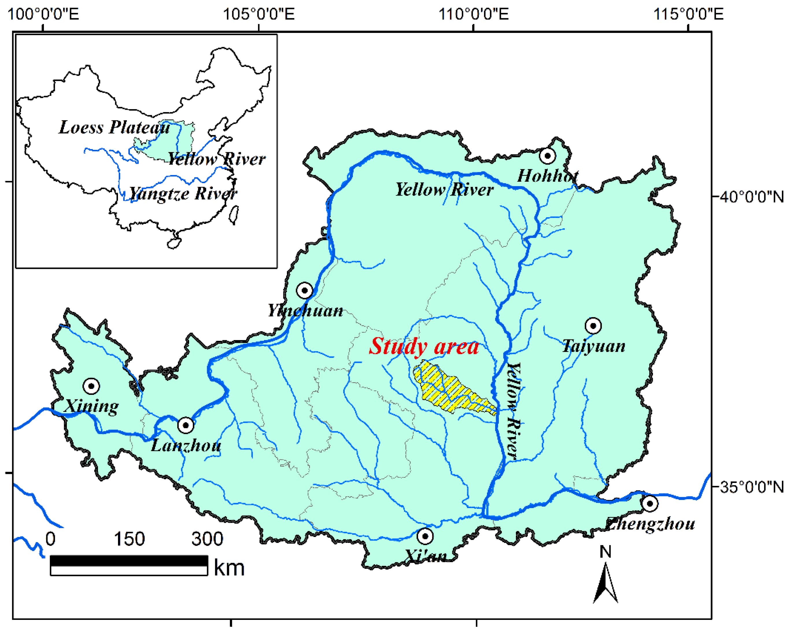
2.1. Study Site

The Yanhe River catchment is located in the central part of China’s Loess Plateau between 36°23′–37°17′ N latitude and 108°45′–110°28′ E longitude (Figure 1). It covers an area of 7687 km2, and is characterized by hills and gullies. The average slope is 4.3% and gully density is 4.7 km·km−2. Elevations vary from 495 m to 1795 m above sea level. The catchment has a semi-arid continental climate; its mean annual precipitation varies from 420 mm to 539 mm, nearly 70% of which falls between May and September, and the annual mean temperature varies from 5.7 °C in the northwest to 12.6 °C in the southwest. According to general vegetation zonality, warm temperate deciduous broadleaf forest and mixed coniferous-deciduous broadleaf forest should occur in the southeast, temperate forest-steppe in the middle, and steppe and desert-steppe in the northwest [22].
The Yanhe River catchment has experienced high rates of deforestation in the past, resulting in the conversion of natural vegetation to farmland even on steep slopes, which has caused serious soil erosion [37]. As a central part of the Loess Plateau, it is the focus area of many restoration programs carried out in the region [4]. In these programs, many trees have been planted in the catchment. However, the extent to which planted trees have been mismatched with sites remains an open question that is addressed in this study.

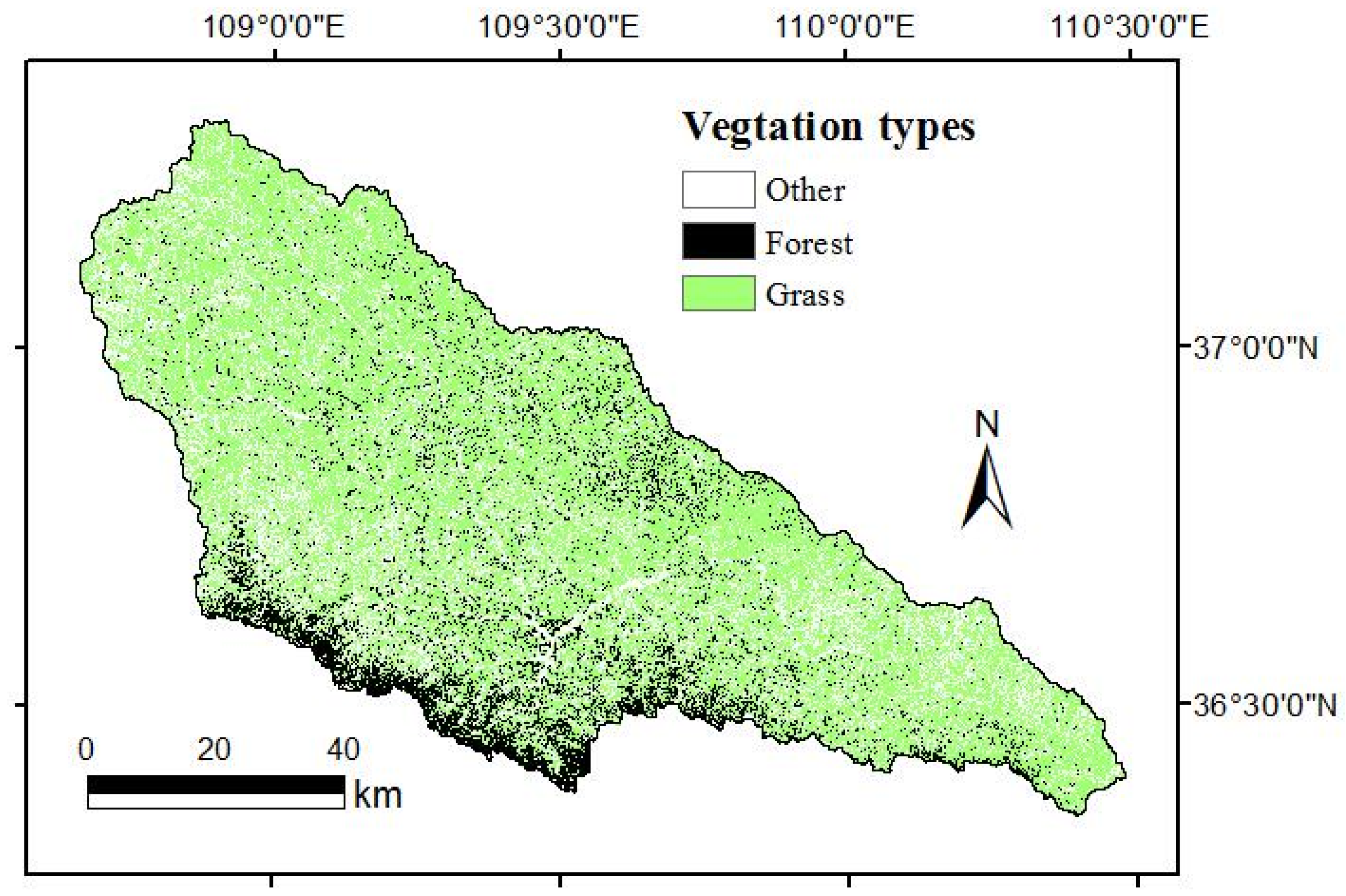
2.2. Actual Vegetation Distribution Map

The actual vegetation map we used represented the plant community cover at the time of mapping. It was derived from a land use map provided by the RS/GIS Lab of the Institute of Soil and Water Conservation (ISWC), Chinese Academy of Sciences (CAS). The laboratory has produced a time series of land use maps for monitoring soil erosion in the Yanhe River catchment. These land use maps were extracted using a supervised classification method based on Landsat Thematic Mapper (TM) images and include six different land use types, namely farmland, forest land, grass land, water bodies, constructions and unused land. In this study, the land use map for 2013 was selected to match our field work, which was carried out in 2013. For comparison with PNV, only two vegetation types, forest and grass, were depicted on the map with the remaining four land use classes amalgamated as one type of land use (Figure 2).

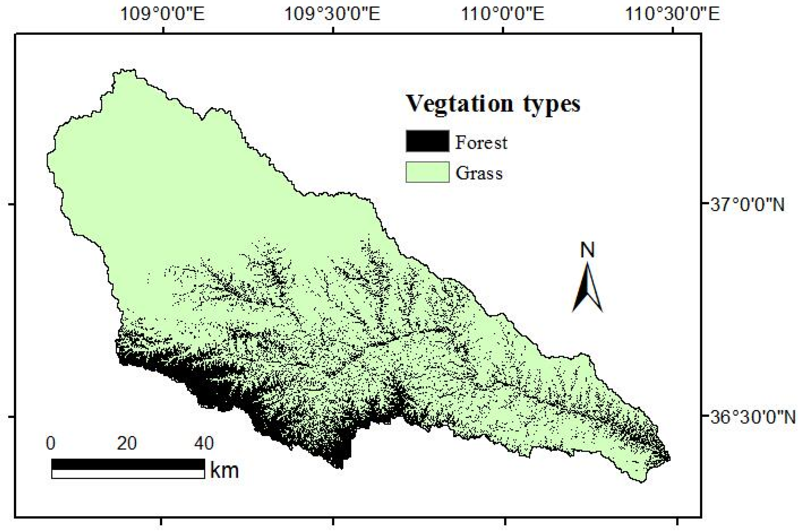
2.3. Potential Natural Vegetation (PNV) Map

The PNV map used in this study was produced by Wen, Jiao and Jiao [34]. The prediction was based on sparsely distributed remnant natural vegetation within this highly fragmented landscape using generalized additive models in GRASP [38,39]. The PNV map included the probabilities of 15 natural vegetation types occurring in each pixel of the Yanhe River catchment. The reliability of the PNV map has been tested using independent field data in several studies [40,41]. For comparison with actual forest in terms of its spatial distribution and environmental characteristics of sites, the predicted PNV map was summarized into the same two growth forms, forest and grass, as the land use map (Figure 3).

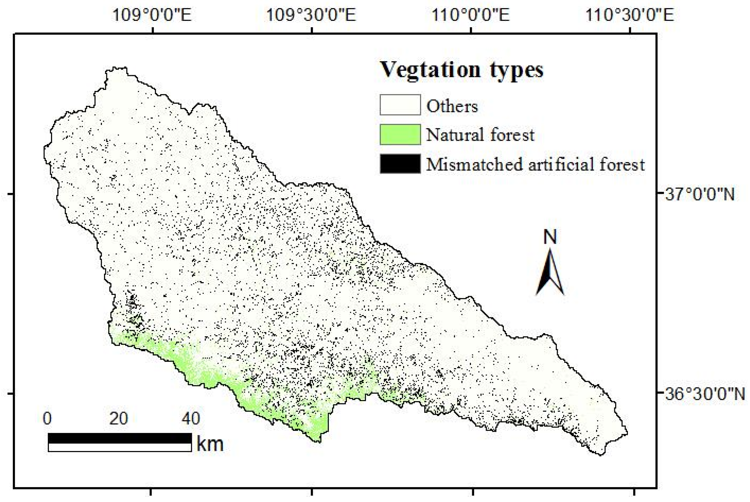
2.4. Comparison of Actual Vegetation and PNV

With the PNV map as a reference, we compared the distribution of actual and potential vegetation on a pixel by pixel (25 m × 25 m) basis using overlay analysis in ArcGIS 10.2. This allowed us to identify the actual forest distributed beyond the boundary of potential natural forest. Sites supporting planted forest beyond the boundary of natural forest were identified from ‘grass’ pixels in the PNV map that were classified as ‘forest’ pixels in the actual vegetation map. For simplicity, we hereafter refer to the planted forest mismatched with PNV as mismatched planted forest. Pixels categorized as ‘forest’ in both the PNV and actual vegetation maps indicated sites where trees had been planted in the right places or were potentially natural remnant forest. All pixels that were not forest or grass (i.e., farmland, water bodies, constructions and unused land in the original land use map) remained classified as ‘other’ following the overlay analysis.
Based on the overlay analysis, we extracted climatic and topographic conditions for pixels of mismatched planted forest and natural forest using the thematic layers of rainfall, temperature, evaporation, slope, aspect, and slope position. Rainfall, temperature, and evaporation were calculated from meteorological data from 57 weather stations within and around the study area using the method introduced in references [34,42,43,44]. All climate data were updated to 2013. These data were then interpolated into individual 25 m × 25 m pixels using the thin plate spline method with ANUSPLINE (Version 4.3), with slope and aspect as covariates [34,42,43,44]. Slope, aspect, and landscape position were estimated from a digital elevation model (DEM) with a resolution of 25 m [34]. t-tests for two independent samples were carried out to test the differences in these variables between potential natural forest and mismatched planted forest.

2.5. Soil Water Content under Potential Natural and Mismatched Planted Forests

Soil water content is regarded as a major limiting factor of vegetation restoration in the Loess Plateau [6,45]; we therefore investigated the soil water content under natural forest and mismatched planted forest sites to see if significant differences exist between them. Based on the distribution of the natural and mismatched forest in the catchment, we randomly selected 12 natural forest sample plots and 12 mismatched planted forest plots to investigate soil water content. The soil samples were collected at intervals of 20 cm from the soil surface to a depth of 5 m, and the soil water content was determined by oven drying. The soil water content was averaged from the different layers to derive the mean soil water content of sampling points. We also identified the dominant plant species in each plot.
Finally, we used unpaired t-tests to compare means of temperature, rainfall, evaporation and slope between natural and mismatched planted forest. Levene’s test was used to assess the homogeneity of variance.

3. Results

3.1. Distribution of Mismatched Planted Forest in the Yanhe River Catchment

The statistical summary of the overlay analysis showed that 58% of existing forest was identified as mismatched planted forest (Figure 4). Those mismatched pixels were distributed across the whole catchment, while the natural forest was mainly distributed in the south of the catchment and along stream channels (Figure 2). From the middle to the south of the catchment, the distribution of mismatched planted forest and natural forest was interlaced. This may be attributed to favourable microhabitats resulting from the complex topography along the stream channel.

3.2. Environmental Conditions of Natural and Mismatched Planted Forest

According to the extracted information, the natural and mismatched planted forests were distributed in almost identical rainfall ranges (465–539 mm vs. 463–538 mm) and temperature ranges (6–12 °C vs. 6–12 °C ), but the mean values for rainfall and temperature were significantly different from each other (*** p < 0.001, Table 1). The mean rainfall and temperature for natural forest were 512.20 ± 11.42 mm and 8.23 ± 0.55 °C, respectively, but 497.96 ± 14.92 mm and 8.72 ± 0.97 °C, respectively, for mismatched planted forest (Table 1). Evaporation was not only different in range (816–953 mm vs. 816–1023 mm), but also significantly different in mean values (888.31 ± 14.35 mm natural forest vs. 895.90 ± 30.55 mm planted forest, *** p < 0.001). The mismatched planted forest was usually distributed at sites having lower rainfall, higher temperature and higher evaporation. The slope gradient of natural forest and mismatched planted forest was also significantly different (*** p < 0.001, Table 1), with the mismatched planted forest being usually distributed on steeper slopes.

3.3. Soil Water Content under Natural and Mismatched Planted Forest

The soil water content was significantly different between natural forest and mismatched planted forest (Table 2, ** p < 0.05). The soil water content under planted forest was significantly lower than that under natural forest. The average soil water content was 5.98% ± 0.32% for mismatched planted forest while it was 7.52% ± 0.33% for natural forest.

4. Discussion

4.1. Climate and Topographic Conditions of Natural and Mismatched Planted Forest

By comparing the actual vegetation and potential natural vegetation (PNV) distribution maps on a pixel by pixel basis, this paper showed that 58% of the existing forest in the Yanhe River catchment is planted forest mismatched with sites. Compared with natural forest, mismatched planted forest tends to be distributed at sites with lower rainfall, higher temperature, higher evaporation, and steeper slopes, making it difficult to replenish the used soil water [46]. The planted forest usually possesses higher biomass and uses more water than herb species [47], and this may account for the depletion of soil water resources in the upper soil layer at sites mismatched with forest. Meanwhile, in most parts of the Loess Plateau, evaporation (E0) ranges from 800–1000 mm, which is higher than precipitation (about 400–600 mm). Therefore, the deep soil water cannot be recharged by natural rainfall [13,14]. On the other hand, soil profiles of the Loess Plateau tend to be very deep and soil water that is available for plants cannot be recharged by groundwater [15]. Consequently, soil water deficit occurs very easily under planted forest that is planted where grassland should potentially occur [21,48,49,50]. According to Jing and Zheng [9], if the soil water content is close to or below 6.70%, Robinia pseudoacacia growth will be impaired and even stopped. Our investigation showed that the average soil water content under mismatched planted forest was 5.98% ± 0.32%, indicating that trees have been planted in unsuitable sites. For these sites, we suggest that they should be restored to grasslands or allowed to recover without human intervention. Some studies indicated that naturally restored grassland can also reduce sediment production by 92.71% with farmland as a control [51]. In terms of soil and water conservation, there is no need to plant tree species on these sites.
Our results also showed that mismatched planted forest was commonly distributed on steeper slopes. This agreed with the previous investigation of “old dwarf tees” [52], further confirming that trees have been planted at unsuitable sites. Although previous studies have investigated changes in soil water content in relation to solar aspect [53,54], and topographic position [55,56], active avoidance of unfavorable conditions has been proposed [52], but without consideration of climatic heterogeneity and slope gradient impact. Regardless, even at sites with a northerly aspect and low topographic position, the soil water content is still too low to support the normal growth of trees.

4.2. Implications for Ecological Management in the Loess Plateau

Using the PNV map as a reference, this paper showed that vast areas of trees have been planted on unsuitable, steep sites with low rainfall, high temperature and high evaporation. This may be the main cause of dwarfed, slender, low productive and sparse forest in the Loess Plateau [11]. This finding is instructive for regional landscape planning and the management of existing planted forests as an enhanced understanding of the causes for problems in forest plantations may lead to different actions in practice. For the Loess Plateau, if we think, just as many scholars previously thought [6,21,45,57], that the soil water deficit was the main cause of dwarfed, slender, low productive and sparse planted forest, then more effort would be devoted to water harvesting techniques [6,7], which are techniques used to collect rainfall water around the planted tree to improve the survival of species. In contrast, by understanding that the main causes for these plantation problems relate to site selection, we can invest more resources in understanding environmental heterogeneity and the capacity of this complex landscape to support different vegetation types.
Water harvesting techniques have been widely used to support afforestation in the Loess Plateau but an increasing number of studies show that water harvesting is costly and not as successful as expected. In the preparation of fish scale pits (a water harvesting and site preparation technique), vegetation cover can be reduced by 15% [19], and a further reduction (30.5%) can occur through site preparation by water harvesting techniques [8]. Wide use of water harvesting techniques has also been found to cause severe soil erosion in the first few years after it occurs [8,19] with serious hydrological consequences [8]. According to Li, Liu, Gao, Shi, Zou and Zhang [6], the optimal catchment/planted area ratios for the growing Tamarix ramosissima is 38.2 to 19.1, which means a single T. ramosissima tree (planted area assumed to be 1 m2) needs 19.1–38.2 m2 to support its growth. Moreover, the development of understory vegetation may be suppressed due to its inferior position in competition for water with trees [19]. Therefore, instead of water harvesting techniques, we suggest that more focus in the future is placed on detecting environmental heterogeneity and its influence over different vegetation types. The first priority is to make sure that we plant trees on the right sites rather than modify site conditions for trees.

5. Conclusions

The study used an existed potential natural vegetation (PNV) map as a reference to compare its distribution with actual forest and to analyze environmental conditions of potential natural forest and actual forest. The result showed that 58% of the existing forest in Yanhe river catchment was planted forest mismatched with sites, which were characterized with lower rainfall, higher temperature and evaporation and steeper slopes and lower soil water content. Planting trees in these sites is the main cause of dwarfing, slender, low productive forest in Loess Plateau. This conclusion is of significance to practical restoration planning and forest management. Instead of investing limited resources in water harvesting techniques for planting trees, more focus should be placed on understanding environmental heterogeneity and its capacity to support particular vegetation types.

Acknowledgments

This study was supported the National Natural Science Foundation of China (41501055, 41271297), the CAS “light of West China” program (XAB2015B08), and PhD Start-up Fund of Northwest A & F University (2452015342). We are grateful for the RS/GIS Laboratory at the Institute of Soil and Water Conservation (ISWC), Chinese Academy of Sciences (CAS) for land use data.

Author Contributions

Haijing Shi designed the study, conducted statistical analysis and drafted the manuscript. Zhongming Wen proposed the idea, wrote the protocol and supervised all work. David Paull edited the manuscript and managed the literature searches. Feng Jiao co-designed the study and carried out data and specimen collection. All authors read and approved the final manuscript.

Conflicts of Interest

The authors declare no conflict of interest.

References

  1. Chen, L.; Wei, W.; Fu, B.; Lü, Y. Soil and water conservation on the Loess Plateau in China: Review and perspective. Prog. Phys. Geogr. 2007, 31, 389–403. [Google Scholar] [CrossRef]
  2. Zhao, G.; Mu, X.; Wen, Z.; Wang, F.; Gao, P. Soil erosion, conservation, and eco-environment changes in the Loess Plateau of China. Land Degrad. Dev. 2013, 24, 499–510. [Google Scholar] [CrossRef]
  3. Li, F.R.; Gao, C.Y.; Zhao, H.L.; Li, X.Y. Soil conservation effectiveness and energy efficiency of alternative rotations and continuous wheat cropping in the Loess Plateau of northwest China. Agric. Ecosyst. Environ. 2002, 91, 101–111. [Google Scholar] [CrossRef]
  4. Wenhua, L. Degradation and restoration of forest ecosystems in China. For. Ecol. Manag. 2004, 201, 33–41. [Google Scholar] [CrossRef]
  5. Zhou, Z.; Gan, Z.; Shangguan, Z.; Dong, Z. China’s grain for green program has reduced soil erosion in the upper reaches of the yangtze river and the middle reaches of the yellow river. Int. J. Sustain. Dev. World Ecol. 2009, 16, 234–239. [Google Scholar] [CrossRef]
  6. Li, X.Y.; Liu, L.Y.; Gao, S.Y.; Shi, P.J.; Zou, X.Y.; Zhang, C.L. Microcatchment water harvesting for growing tamarix ramosissima in the semiarid loess region of China. For. Ecol. Manag. 2005, 214, 111–117. [Google Scholar] [CrossRef]
  7. Yang, X.H.; Wang, K.Q.; Wang, B.R.; Yu, C.T. Afforestation using micro-catchment water harvesting system with microphytic crust treatment on semi-arid Loess Plateau: A preliminary result. J. For. Res. 2005, 16, 9–14. [Google Scholar]
  8. Cao, S. Why large-scale afforestation efforts in China have failed to solve the desertification problem. Environ. Sci. Technol. 2008, 42, 1826–1831. [Google Scholar] [CrossRef] [PubMed]
  9. Jing, K.; Zheng, F. Experiential lesson and perspective of vegetation construction on the Loess Plateau. Res. Soil Water Conserv. 2004, 11, 25–27. (In Chinese) [Google Scholar]
  10. In, T.; Wang, K.; Wang, Y. On vegetation reconstruction in Loess Plateau of northern shaanxi. Shaanxi For. Sci. Technol. 2009, 1, 105–107. (In Chinese) [Google Scholar]
  11. Zhang, J. Theory and techniques of vegetation restoration and vonstruction on Loess Plateau, China. J. Soil Water Conserv. 2004, 18, 120–124. (In Chinese) [Google Scholar]
  12. Wang, Y.Q.; Shao, M.A.; Shao, H.B. A preliminary investigation of the dynamic characteristics of dried soil layers on the Loess Plateau of China. J. Hydrol. 2010, 381, 9–17. [Google Scholar] [CrossRef]
  13. Chen, L.; Wang, J.; Wei, W.; Fu, B.; Wu, D. Effects of landscape restoration on soil water storage and water use in the Loess Plateau region, China. For. Ecol. Manag. 2010, 259, 1291–1298. [Google Scholar] [CrossRef]
  14. Wang, Y.Q.; Shao, M.A.; Liu, Z.P. Large-scale spatial variability of dried soil layers and related factors across the entire Loess Plateau of China. Geoderma 2010, 159, 99–108. [Google Scholar] [CrossRef]
  15. Li, Y. Effects of forest on water circle on the Loess Plateau. J. Nat. Resour. 2001, 16, 427–432. (In Chinese) [Google Scholar]
  16. Shangguan, Z.P. Soil desiccation occurrence and its impact on forest vegetation in the Loess Plateau of China. Int. J. Sustain. Dev. World Ecol. 2007, 14, 299–306. [Google Scholar] [CrossRef]
  17. Chen, H.; Shao, M.; Li, Y. Soil desiccation in the Loess Plateau of China. Geoderma 2008, 143, 91–100. [Google Scholar] [CrossRef]
  18. Jun, L.; Bing, C.; Xiaofang, L.; Yujuan, Z.; Yangjing, C.; Bin, J.; Wei, H.; Jimin, C.; Ming’an, S. Effects of deep soil desiccation on artificial forestlands in different vegetation zones on the Loess Plateau of China. Acta Ecol. Sin. 2008, 28, 1429–1445. [Google Scholar] [CrossRef]
  19. Wen, Z.; Yang, Q.; Jiao, F. Impacts of soil and water conservation on regional vegetation succession: A case study of Loess Plateau. Sci. Soil Water Conserv. 2005, 3, 32–37. (In Chinese) [Google Scholar]
  20. Fan, J.; Shao, M.A.; Wang, Q.J.; Jones, S.B.; Reichardt, K.; Cheng, X.R.; Fu, X.L. Toward sustainable soil and water resources use in China’s highly erodible semi-arid Loess Plateau. Geoderma 2010, 155, 93–100. [Google Scholar]
  21. Han, R.; Hou, Q. An analysis of genesis of small aged trees on the Loess Plateau. Agric. Res. Arid Areas 1996, 14, 104–108. (In Chinese) [Google Scholar]
  22. Zou, H.; Guan, X.; Han, R.; Zhang, X. The probe of ecological basis of vegetation-renewing in Loess Plateau. J. Soil Water Conserv. 1995, 9, 1–4. (In Chinese) [Google Scholar]
  23. Liang, Y. Discussing issues about establishing vegetation on Loess Plateau according to the law of community. Acta Bot. Boreal. Occident. Sin. 1999, 19, 026–031. (In Chinese) [Google Scholar]
  24. Zhu, Z. Basic features of forest steppe in the Loess Plateau. Sci. Geogr. Sin. 1994, 14, 152–156. (In Chinese) [Google Scholar] [CrossRef]
  25. Tüxen, R. Die Heutige Potentielle Natürliche Vegetation als Gegenstand der Vegetationskartierung. Angewandte Pflanzensoziologie 1956, 13, 5–42. [Google Scholar]
  26. De Keersmaeker, L.; Rogiers, N.; Vandekerkhove, K.; De Vos, B.; Roelandt, B.; Cornelis, J.; De Schrijver, A.; Onkelinx, T.; Thomaes, A.; Hermy, M.; et al. Application of the ancient forest concept to potential natural vegetation mapping in flanders, a strongly altered landscape in northern belgium. Folia Geobot. 2013, 48, 137–162. [Google Scholar] [CrossRef]
  27. Mueller-Dombois, D.; Ellenberg, H. Aims and Methods of Vegetation Ecology; The Blackburn Press: Caldwell, NJ, USA, 2002. [Google Scholar]
  28. Wang, H.; Ni, J.; Prentice, I.C. Sensitivity of potential natural vegetation in China to projected changes in temperature, precipitation and atmospheric CO2. Reg. Environ. Chang. 2011, 11, 715–727. [Google Scholar] [CrossRef] [Green Version]
  29. Brzeziecki, B.; Kienast, F.; Wildi, O. A simulated map of the potential natural forest vegetation of switzerland. J. Veg. Sci. 1993, 4, 499–508. [Google Scholar] [CrossRef]
  30. Xie, Y.; Sha, Z.; Yu, M. Remote sensing imagery in vegetation mapping: A review. J. Plant Ecol. 2008, 1, 9–23. [Google Scholar] [CrossRef]
  31. Franklin, J. Predictive vegetation mapping: Geographic modelling of biospatial patterns in relation to environmental gradients. Prog. Phys. Geogr. 1995, 19, 474–499. [Google Scholar] [CrossRef]
  32. Del Arco Aguilar, M.J.; González-González, R.; Garzón-Machado, V.; Pizarro-Hernández, B. Actual and potential natural vegetation on the canary islands and its conservation status. Biodivers Conserv. 2010, 19, 3089–3140. [Google Scholar] [CrossRef]
  33. Zerbe, S. Potential natural vegetation: Validity and applicability in landscape planning and nature conservation. Appl. Veg. Sci. 1998, 1, 165–172. [Google Scholar] [CrossRef]
  34. Wen, Z.; Jiao, F.; Jiao, J. Prediction and mapping of potential vegetation distribution in Yanhe river catchment in hilly area of Loess Plateau. Chin. J. Appl. Ecol. 2008, 19, 1897–1904. (In Chinese) [Google Scholar]
  35. Ricotta, C.; Carranza, M.L.; Avena, G.; Blasi, C. Are potential natural vegetation maps a meaningful alternative to neutral landscape models? Appl. Veg. Sci. 2002, 5, 271–275. [Google Scholar] [CrossRef]
  36. Zhou, D.; Zhao, S.; Zhu, C. The grain for green project induced land cover change in the Loess Plateau: A case study with ansai county, Shanxi Province, China. Ecol. Indic. 2012, 23, 88–94. [Google Scholar] [CrossRef]
  37. Su, C.; Fu, B.; Lu, Y.; Lu, N.; Zeng, Y.; He, A.; Lamparski, H. Land use change and anthropogenic driving forces: A case study in Yanhe river basin. Chin. Geogr. Sci. 2011, 21, 587–599. [Google Scholar] [CrossRef]
  38. Lehmann, A.; Overton, J.M.; Leathwick, J.R. Grasp: Generalized regression analysis and spatial prediction. Ecol. Model. 2002, 157, 189–207. [Google Scholar] [CrossRef]
  39. Lehmann, A.; Leathwick, J.R.; Overton, J.M. Grasp User’s Manual; Landcare Reaearch: Hamilton, New Zealand, 1999. [Google Scholar]
  40. Shi, Y.; Wen, Z.; Gong, S. Comparisons of relationships between leaf and fine root traits in hilly area of the Loess Plateau, Yanhe river basin, Shaanxi Province, China. Acta Ecol. Sin. 2011, 31, 6805–6814. (In Chinese) [Google Scholar]
  41. Gong, S.; Wen, Z.; Shi, Y. The response of community-weighted mean plant functional traits to environmental gradients in Yanhe river catchment. Acta Ecol. Sin. 2011, 31, 6088–6097. (In Chinese) [Google Scholar]
  42. Kelly, A.; Powell, D.C.; Riggs, R.A. Predicting potential natural vegetation in an interior northwest landscape using classification tree modeling and a gis. West. J. Appl. For. 2005, 20, 117–127. [Google Scholar]
  43. Dobrowski, S.Z.; Safford, H.D.; Cheng, Y.B.; Ustin, S.L. Mapping mountain vegetation using species distribution modeling, image-based texture analysis, and object-based classification. Appl. Veg. Sci. 2008, 11, 499–508. [Google Scholar] [CrossRef]
  44. Jiao, J.Y.; Tzanopoulos, J.; Xofis, P.; Mitchley, J. Factors affecting distribution of vegetation types on abandoned cropland in the hilly-gullied Loess Plateau region of China. Pedosphere 2008, 18, 24–33. [Google Scholar] [CrossRef]
  45. Xinxiao, Y.; Lihua, C. The countermeasures to combat small but old trees in loess area of west Shanxi. J. Arid Land Resour. Environ. 1996, 10, 81–86. (In Chinese) [Google Scholar]
  46. Wang, Z.; Liu, B.; Wang, X.; Han, Y. Soil water restoration of different land use after artificial forest in the semi-arid area of Loess Plateau. Trans. CSAE 2007, 23, 77–83. (In Chinese) [Google Scholar]
  47. Zhang, C.; Jiao, F.; Wen, Z.; Wang, X. Differences of above-ground biomass and comparisons of its effect on soil moisture between natural vegetation and artificial vegetation in Yanhe basin. J. Northwest A & F Univ. (Natural Science Edition) 2011, 39, 132–138. (In Chinese) [Google Scholar]
  48. Hou, Q.; Huang, X.; Han, S.; Zhang, X. Study on the forming of “small old tree” and transforming way in the Loess Plateau iii: The genesis of small old trees and ways of their transformation. Acta Conserv. Soliet Aquae Sin. 1991, 5, 80–86. (In Chinese) [Google Scholar]
  49. Wang, L.; Shao, M.; Li, Y. Study on relationship between growth of artificial Robinia pseudoacacia plantation and soil desiccation in the Loess Plateau of northern Shannxi Province. Sci. Silv. Sin. 2004, 40, 84–91. (In Chinese) [Google Scholar]
  50. Yu, X.; Chen, L. The countermeasures to combat small but old trees in loess area of west shanxi. J. Arid Land Resour. Environ. 1996, 10, 81–86. (In Chinese) [Google Scholar]
  51. Hua, D.; Wen, Z. Study on the runoff and sediment under simulated rainstorm conditions of different stages of vegetation restoration in loess hilly region, China. J. Soil Water Conserv. 2015, 29, 27–31. [Google Scholar]
  52. Hou, Q.; Huang, X.; Han, S. Study on the forming of “small olded-tree” and the transforming way in the Loess Plateau I: The distribution and growth nature of the small old tree. Acta Conserv. Soliet Aquae Sin. 1991, 5, 64–72. (In Chinese) [Google Scholar]
  53. Jia, H.; Liu, Y.; Xu, X.; Wang, K.; Gao, Q. Simulation of soil water dynamics in a caragana intermedia woodland in huangfuchuang watershed: Relationships among slope, aspect, plant density and soil water content. Acta Phytoecol. Sin. 2005, 29, 910–917. (In Chinese) [Google Scholar]
  54. Hu, Z.; Feng, H.; Wang, D.; Zhang, Y. Slope soil water characteristics analysis in loess gully area in western shanxi province. J. Shanxi Agric. Univ. (Natural Science Edition) 2009, 29, 257–260. (In Chinese) [Google Scholar]
  55. He, F.; Huang, M.; Dang, T. Soil water distribution characteristics in wangdonggou watershed in gully region of Loess Plateau. Bull. Soil Water Conserv. 2002, 22, 6–9. (In Chinese) [Google Scholar]
  56. Xu, X.; Liu, W.; Gao, P.; Mu, X. The discussion on soil moisture distributional diversity in hilly Loess Plateau region. Ecol. Environ. 2003, 12, 52–55. (In Chinese) [Google Scholar]
  57. Hou, Q.; Huang, X.; Han, S.; Zhang, X. Study on the forming of “small olded tree” and the transforming way in the Loess Plateau II: The status of soil moistures and nutrients in small old tree stands and impact on tree growth. Acta Conserv. Soliet Aquae Sin. 1991, 5, 75–83. (In Chinese) [Google Scholar]
Figure 1. Location of the Yanhe river catchment in the Loess Plateau, China.
Forests 07 00258 g001
Figure 2. Distribution of actual vegetation in the Yanhe River catchment.
Forests 07 00258 g002
Figure 3. Predictive distribution of potential natural vegetation (PNV) in the Yanhe River catchment.
Forests 07 00258 g003
Figure 4. Distribution of mismatched planted forest (the actual forest beyond the boundary of potential natural forest) and natural forest in the Yanhe River catchment.
Forests 07 00258 g004
Table 1. Statistical tests for equality of variances (Levene’s Test) and means (t-test) in environmental variables between natural and mismatched planted forest.
Pair Samples of Environmental VariablesSample NumberMean ± SDStd. Error MeanLevene’s Test for Equality of Variancest-Test for Equality of Means
Average rainfall (mm)Natural forest373,603512.20 ± 11.420.019p < 0.001p < 0.001
Planted forest517,393497.96 ± 14.920.018
Average Temperature (°C)Natural forest373,6038.23 ± 0.550.003p < 0.001p < 0.001
Planted forest517,3938.72 ± 0.970.001
Average Evaporation (mm)Natural forest373,603888.31 ± 14.350.024p < 0.001p < 0.001
Planted forest517,393895.90 ± 30.550.043
Slope gradient (°)Natural forest373,60322.66 ± 8.820.015p < 0.001p < 0.001
Planted forest517,39324.24 ± 9.860.014
Table 2. The average soil water content (SW) under natural and mismatched planted forest in the Yanhe River catchment. t-Test with 95% intervals: t = −3.36, p = 0.003.
Natural ForestPlanted Forest
Dominant SpeciesLocationsAverage SW at a Depth of 5 m (%)Dominant SpeciesLocationsAverage SW at a Depth of 5 m (%)
Populus davidiana Dode109°26.940′ N, 36°32.573′ E8.79Robinia pseudoacacia109°03.867′ N, 37°06.476′ E5.53
Ulmus macrocarpa Hance
Spiraea pubescens Turcz
Populus davidiana Dode109°25.674′ N, 36°27.015′ E9.89Robinia pseudoacacia108°52.811′ N, 37°02.279′ E4.23
Syringa pekinensis Rupr109°25.564′ N, 36°27.052′ E7.05Robinia pseudoacacia109°06.324′ N, 36°53.413′ E5.56
Cotoneaster acutifolius Turcz
Platycladus orientalis109°16.665′ N, 36°29.438′ E6.38Robinia pseudoacacia109°09.027′ N, 36°49.547′ E6.18
Quercus liaotungensis Koidz109°16.642′ N, 36°29.154′ E6.70Robinia pseudoacacia109°24.645′ N, 36°55.621′ E7.29
Acer palmatum Thunb
Platycladus orientalis109°17.958′ N, 36°30.473′ E5.96Robinia pseudoacacia109°21.779′ N, 37°00.618′ E7.31
Platycladus orientalis109°20.275′ N, 36°32.038′ E7.56Robinia pseudoacacia109°17.268′ N, 36°56.188′ E5.59
Syringa pekinensis Rupr109°20.105′ N, 36°52.254′ E6.41Robinia pseudoacacia109°50.267′ N, 36°43.523′ E7.42
Ostryopsis davidiana
Ostryopsis davidiana109°19.849′ N, 36°52.388′ E7.26Robinia pseudoacacia109°37.873′ N, 36°47.111′ E6.58
Ostryopsis davidiana109°26.856′ N, 36°32.563′ E7.53Robinia pseudoacacia110°10.951′ N, 36°30.876′ E4.10
Sophora davidii109°26.846′ N, 36°32.616′ E8.54Robinia pseudoacacia110°02.206′ N, 36°34.080′ E5.75
Zizyphus jujuba var. spinosa
Sophora davidii109°20.422′ N, 36°51.985′ E8.22Robinia pseudoacacia109°55.363′ N, 36°34.012′ E6.20
Average value-7.52Average value-5.98

