Article

Fire Scenarios in Spain: A Territorial Approach to Proactive Fire Management in the Context of Global Change

1
Department of Regional Geographical Analysis and Physical Geography, Faculty of Geography and History, Complutense University of Madrid, Madrid 28040, Spain
2
Department of Geography, Universidad Autónoma de Madrid, Madrid 28049, Spain
*
Author to whom correspondence should be addressed.
Forests 2016, 7(11), 273; https://doi.org/10.3390/f7110273
Submission received: 8 September 2016 / Revised: 22 October 2016 / Accepted: 8 November 2016 / Published: 12 November 2016

Abstract

:
Humans and fire form a coupled and co-evolving natural-human system in Mediterranean-climate ecosystems. In this context, recent trends in landscape change, such as urban sprawl or the abandoning of agricultural and forest land management in line with new models of economic development and lifestyles, are leading to new fire scenarios. A fire scenario refers to the contextual factors of a fire regime, i.e., the environmental, socio-economic and policy drivers of wildfire initiation and propagation on different spatial and temporal scales. This is basically a landscape concept linking territorial dynamics (related to ecosystem evolution and settlement patterns) with a fire regime (ignition causes; spread patterns; fire frequency, severity, extent and seasonality). The aim of this article is to identify and characterize these land-based fire scenarios in Spain on a national and regional scale, using a GIS-based methodology to perform a spatial analysis of the area attributes of homogenous fire spread patterns. To do this, the main variables considered are: land use/land cover, fuel load and recent fire history. The final objective is to reduce territorial vulnerability to forest wildfires and facilitate the adaptation of fire policies and land management systems to current challenges of preparedness and uncertainty management.

1. Introduction

Forested and non-forested lands around the world, especially in Mediterranean-climate regions, tend to be highly fire-prone and ecologically diverse, with fire playing an important role in ecosystem structure and function [1,2]. Many of these regions also support large human populations, and thus fire hazard and risk management have become central concerns [3], particularly given the projections of increased fire activity with global climate change and ongoing land use change [4]. Alteration of fire regimes in Mediterranean-climate ecosystems poses substantial threats to ecosystems and settlements, but fire management may not be implemented by the same agencies as land management and asset protection. Thus, conflicts may emerge in management objectives and outcomes, with both people and ecosystems at stake. In fact, humans and fire represent a coupled and co-evolving natural-human system in Mediterranean-climate ecosystems [5,6,7], and the resilience or sustainability of both requires them to be considered jointly. Given that the behavior of one system has an impact on the behavior of the other, the goal is to identify how and where action can be taken for their mutual benefit in this era of global change. Fire scenarios are a potential approach to achieving balanced fire hazard reduction and land management by assessing the interactions of fire and people [8].
The concept of a fire scenario is useful when confronted with the need to coexist with fire [6,9,10,11] and entails understanding societal discourses and risk constructs at the landscape scale [12]. Fire scenarios were first defined by the technical unit of the Forest Action Support Group (Grup de Recolzament d’Actuacions Forestals—Unitat Técnica, GRAF-UT, Catalonia, Spain), from a territorial perspective, to identify a ‘problem fire’ and to engage in appropriate planning. Fire scenarios were defined as areas of homogenous fire spread patterns [10,13]. This concept derives from earlier terms such as ‘fire environment’, defined as the conditions and modifying forces controlling fire behavior [14]. Recently, the term ‘landscape management scenario’ has also been used to assess the relationship between fuel treatment, wildfire risk and wildlife management [15].
In contrast to this context-specific, location-based approach to fire scenarios [16,17,18], there is also a time-based modeling approach that simulates fire scenarios in relation to alternative temporal pathways for future predictions of wildfire risk [7,19]. In fact, fire scenario is a term with different meanings which is in widespread use in fire ecology and fire management literature. We emphasize a location-based definition of fire scenarios which refers to the dynamic relationship between fire behavior, biological issues (forest ecosystems, plant communities) and socio-economic aspects (land use, land management policies) at a landscape scale. Therefore, it is an integrative concept including bio-geophysical and social structures and processes, providing a large scale perspective suitable for managing ecosystems and mitigating risks to human communities [6,20,21,22,23,24].
The main aim of this article is to identify and characterize fire scenarios in Spain for fire risk assessment. In contrast to other fire risk assessment systems, which provide a spatial evaluation of the most relevant components associated with fire occurrence [25,26,27], our proposal seeks to define, delimit and characterize homogeneous spatial units in terms of fire risk. Taking recent trends in landscape change into account, a conceptual and methodological framework has been defined for territorial zoning and characterization according to fire behavior. The main variables considered are land use/land cover, fuel types and recent fire history [28,29]. The result is the mapping and characterization of 56 existing fire scenarios at a national scale, and the proposal and testing of a methodology to determine fire scenarios at a regional scale. The national fire scenarios are based on the structural characteristics most relevant to fire behavior (with reference to the forest ecosystem and settlement system). They make it possible to define the main principles and actions for prevention and extinction. The regional scenarios, defined in greater detail, introduce a qualitative assessment of the foreseeable landscape dynamics (processes of agricultural abandonment, scattered urban development) and their incidence on wildfire propagation conditions and the circumstances leading to an emergency. The spatial demarcations of these planning units for a fire regime, at both a national and regional level, enable the implementation of standard wildfire protection management in the various scenarios envisaged. This facilitates adaptation and improves the efficiency of the wildfire defense units, reducing territorial vulnerability to forest wildfires through land management measures.

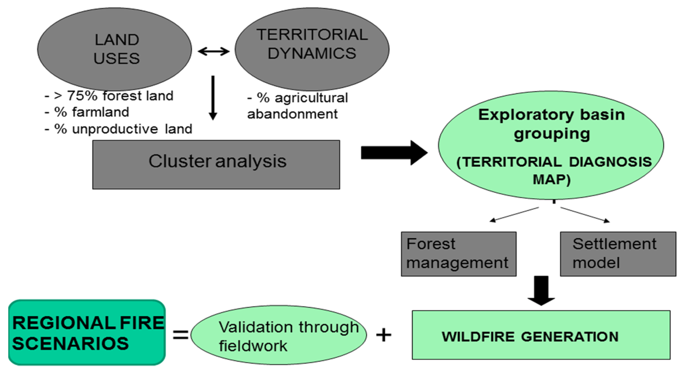
2. Materials and Methods

GIS is an essential tool for quantitative and qualitative analysis of land use and territorial dynamics that define fire scenarios [29]. Fire scenarios have been identified and characterized using a GIS-based methodology to perform a spatial analysis of the area attributes of homogenous fire spread patterns on various scales [30]. Cluster analysis techniques have also been used [31] to define exploratory groups of units as the basis of the territorial diagnosis map which allows fire scenarios to be identified at several scales.

2.1. National Scale

The definition of scenarios on a national scale aims to establish the spatial differentiation of territorial structural characteristics in relation to wildfire risk. From a methodological viewpoint, two issues are analyzed: (i) the variables considered in the characterization mentioned above; and (ii) the spatial unit chosen to assess the distribution of variables.
The elements considered are:
(1)
Settlements: Whether there is high or low population is a factor of maximum importance when configuring fire scenarios, as human lives are the top priority for protection in a fire. The information source used in this article is the settlement map (Mapa de Poblamientos) produced by TRAGSATEC from the coverage in Usos del Sistema de Información Geográfica de Parcelas Agrícolas (SIGPAC, 2005), which has been completed with information from the forest map of Spain (Mapa Forestal de España 1:50,000 (MFE50, 2007), both produced by the Spanish Ministry of the Environment (Ministerio de Medio Ambiente y Medio Rural y Marino). By contrasting the data from these two sources using GIS, 9 population/settlement types were obtained depending on type, density and territorial environment (agricultural, forest) (Table 1).
(2)
Forest ecosystem propagation hazard: defined as the intrinsic propensity of a forest system to propagate fire and become a wildfire. It is estimated from (i) the fuel and forest vegetation model (determined by the degree of combustibility and flammability) and (ii) the physiography (slope dependent and interpreted through topography).
The fuel and forest vegetation model established by Rothermel [32] is used. It has been adapted to Spanish forest systems by the Dirección General de Medio Natural y Política Forestal (MMAMRM), and includes 13 types of fuel models. Models 5, 8, 9, 10, 11, 12 and 13 have been defined as “low combustibility”, and models 1, 2, 3, 4 and 6 as “medium or high combustibility”. On the other hand, the results of the trials carried out in the INIA laboratory to classify plant species flammability have been used to determine which species display high flammability throughout the year or only in summer, which species display moderate or low flammability, and the remaining species [33]. These two variables (combustibility and flammability) are then used to assess the fuel hazard using a decision matrix (Table 2).
On the other hand, three slope intervals are used to assess the propagation hazard depending on physiography (Table 3).
Combining these two risk factors (fuel hazard and topography) yields the decision matrix to assess the potential propagation capacity of the physical medium (Table 4).
The matrix resulting from the relationship between settlement types (Table 1) and forest ecosystem propagation hazard (Table 4) produces 54 situations of wildfire hazard, with a characteristic highly fragmented spatial pattern. The need to define spatial entities large enough to encompass homogenous areas suited to land management and to combat wildfires meant that it was necessary to contrast the defined situations using landscape character assessment [34]. Fire behavior is largely dependent on the landscape pattern. Thus, it is appropriate to use landscape character assessment methods developed on an intermediate scale.
Landscape units thus defined allow for the expression, on a specific scale, of landscape diversity deriving from a particular physiognomy, reflecting the differentiated and differentiable morphological, functional, and visual organization of spatial elements. This is based on the hypothesis that the morphological and functional organization of spatial elements should coincide with differentiated fire regimes. In this case, the atlas of Spanish landscapes (Atlas de los paisajes de España) [35], which uses a simplified version of the methodology established by the Countryside Agency, was used to identify and characterize landscape units in Spain. This spatial level of disaggregation is considered to be the most suitable considering the management goals set for the different fire scenarios. Thus, the 54 wildfire hazard situations were contrasted with the landscape units defined in the atlas.
Previously, and according to the level of disaggregation on a national scale, the wildfire hazard situations were simplified and reduced to just 11: artificial surfaces, settlements in agricultural areas, settlements in forest areas, scattered buildings in agricultural areas, scattered buildings in forest areas, isolated buildings in agricultural areas, isolated buildings in forest areas, cropland, wildland (high propagation capacity), wildland (medium propagation capacity), and wildland (low propagation capacity).
Overlaying the 11 simplified wildfire hazard situations on the landscape unit maps in the atlas of Spanish landscapes confirmed that there is a direct relationship between both maps (Figure 1).
For each landscape unit, each of the 11 simplified wildfire hazard situations was examined, and a cluster analysis was used to group the landscape units with a similar surface distribution, thus obtaining 9 geo-spatial units with a compact spatial pattern (Figure 2):
  • Predominantly agricultural areas with scarce forest presence. Habitats: large, concentrated nuclei. (Countryside, meadows, plains, corridors and intramontane lowlands).
  • Predominantly forested areas with high/medium propagation capacity and low agricultural presence, scarcely populated. (Mountain massifs and ranges, south-western peneplains).
  • Predominantly forested areas with medium propagation capacity and scarce population (Peneplains and piedmont with dehesa pastureland).
  • Agroforest mosaic. Moderate propagation capacity and low population (Sierras and high lands, peneplain environments).
  • Agroforest mosaic. High propagation capacity and densely populated (Southern sierras, Cantabrian rias and coastal areas).
  • Predominantly forested areas with high/medium propagation capacity and minimum agricultural presence and population. (Sierras and mountain massifs).
  • Forested sierras with low/medium propagation capacity.
  • Predominantly urban areas.
  • Marshland.
To define the various fire scenarios at the national level, the different territorial situations in terms of wildfire hazard were analyzed for each natural region mapped by Martínez de Pisón & Molina Holgado [36]. From this new grouping based on similarity, the definitive national fire scenarios were obtained.

2.2. Regional Scale

The identification of regional fire scenarios starts with the demarcation of physically homogeneous spatial areas. These areas can be linked to different contexts or stages in territorial developments in terms of vegetation and land uses (wildfire generation) (Table 5). The concept of wildfire generation therefore stems from a model of fire behavior that shows the progression towards the predominance of large wildland fires (LWFs). The increasing importance of high intensity LWFs that overwhelm fire suppression capabilities is a result of the variations in fuel build-up within a territorial and temporal context. In each case, the characterization of the fire scenarios using the concept of wildfire generation must necessarily adapt to the regional context but always shares common characteristics.
The defined methodology for identifying regional fire scenarios is based on being able to assign each analysis unit (drainage basin with average area of 4.5 km2) to a specific stage of landscape change according to the defined model (wildland fire generations). The advantage of drainage basins is that they can be aggregated in homogeneous areas, as required by the multi-scale approach (they are suitable for both larger and smaller scales), and where necessary they allow situations to be differentiated internally within the forests defined for management. The spatial analysis on a drainage basin scale, used to determine how territories evolve towards the LWF stage, is based on selecting the attributes and data that express the corresponding landscape change (Table 6).
The selection of attributes therefore depends on the character and dynamics of the landscape, both in the past and foreseeable future. Identifying the territorial uses and dynamics related to wildfire generations (level of agricultural abandonment, existence or absence of forest management, spatial arrangement of housing) is carried out in the following stages:
  • Territorial context for vegetation (forest dynamics and agricultural abandonment dynamics): The variables used (proportion of forest, agricultural and non-productive land; proportion of abandoned farmland between 1990 and 2009) are grouped into 6 classes using a cluster analysis for land cover and dynamics. The intensity of agricultural abandonment compared with cultivated land is the main criterion differentiating situations corresponding to the 1st and 2nd generations.
  • Interface between forest land and urban area: similarly, the drainage basins belonging to the 4th wildfire generation are identified by the land cover variables (% of urban area, % of dense forest land).
  • Forest management: Calculated for each forest type (average values for each landscape unit).
Finally, the demarcation of regional scenarios is carried out through interpretation of the territorial diagnosis and land occupation maps, grouping the drainage basins into homogeneous spatial areas from the viewpoint of wildfire propagation (Figure 3).

3. Results

3.1. Conceptual and Theoretical Foundation of Fire Scenarios

Fire scenarios are the result of territorial dynamics that are driven by fire propagation patterns and ignition patterns. They therefore display spatial and integrating characteristics that are linked to the interaction between two complex, dynamic phenomena: landscape and fire.
The origin of this concept is tied to the challenge posed by LWFs that overwhelm the available suppression efforts. Evidence of the limitations of current fire suppression systems to deal with fire risk in high hazard areas and under extreme weather conditions emphasized the need to change fire management strategies by focusing on fire spread patterns and the acquired knowledge of fire behavior on a landscape scale [38,39]. The new concept of fire scenarios is part of a shift in fire suppression strategies that have moved from total indiscriminate attack to confining tactics based on anticipating fire behavior and taking advantage of any opportunity when the fire is vulnerable. Fire scenarios were first used on a landscape scale in the early 21st century in Catalonia (Spain), by identifying the strategic management points (SMP) where fire defense infrastructures and fuel management actions should be implemented to achieve greater effectiveness against LWFs [30,37]. Fire scenarios are therefore a timely concept in the context of new wildland fire types (convective and eruptive fires) and the need to understand new fire behavior patterns [13,40].
Currently, the “LWF generations” theory [30] is the theoretical basis for addressing the drivers of fire propagation patterns, which are evolving towards more rapid and intense wildfires. This refers to the interaction of landscape, land use, prevention/suppression systems and types of wildland fires, defining different spatial patterns in fuel structure, fire behavior and territorial vulnerability to fire hazard. The LWF generations theory explains changes in fuel and fire behavior linked to land use changes, abandoning land management, and urban development. Those drivers are changing the relative importance of grass and woody fuels, as well as vertical and horizontal fuel continuity (Table 7). As a result, some regions are seeing a change from low-intensity surface fires to high-intensity crown fires, while others are evolving towards a convective fire type-model. With this comes the definition of different fire scenarios, requiring different management action and fire defense strategies.
On the other hand, the territorial drivers of ignition pattern evolution are related to fire use practices, population growth and lifestyle. The model explaining fire regime changes in line with socio-economic processes shows an evolution from (1) frequent use of fire for land management (i.e., pre-industrial rural societies) to (2) reduction of fire activity (i.e., depopulation of rural areas due to rural exodus; fire suppression policies), and (3) increase of fire ignition and fire frequency (i.e., conflicts due to land management policies; human presence in shrubland and forests for recreational purposes; WUI development).
Nevertheless, the driving factors of fire regime shift are not critical per se and must be spatially and temporally contextualized [41]. For instance, increasing fire frequency and expanding spatial patterns in southern California are strongly correlated with human population growth [42], while in disadvantaged rural areas of Europe, the main risk factor is just the aging and declining population [2]. Likewise, an increase of biomass and landscape continuity does not necessarily entail a greater fire risk. For example, forest management is a very effective preventive factor in pine groves in Soria (Spain). The driving factors of fire regime change are thus both space and time dependent. Fire scenarios provide a land-based context for assessing and interpreting the effects of ecological and socio-economic factors on fire behavior.
The definition of fire scenarios is a dynamic, spatial and integrative concept. On a regional level it differentiates the scale of interaction between ecosystem characteristics and changes in land use, according to the fire behavior and how it changes, and of increased territorial vulnerability. The components determining fire behavior (climatic, physiographic, biological, and social) have different weighting according to the working scale. The approach used also varies with the scale, but always considers the interaction with the fire regime. We can summarize the main components and spatial scales of land-type fire scenarios as follows:
1. Fuels (ecosystems; plant communities):
Fuel structure determines different fire regimes, such as surface fires and crown fires. The assessment of fuel structure mainly considers vegetation flammability and combustibility, the predictable evolution of combustible biomass, and its proximity to buildings and structures. The indicators used to evaluate fuel structure differ depending on the available information and their suitability to each of the working scales:
-
National scale: the indicator used is propagation capacity, calculated as a function of flammability and combustibility of forest ecosystems, and slope gradient.
-
Regional scale: propagation capacity is evaluated in more detail, by considering forest continuity and structure, as well as the extent of existing agricultural and unproductive land.
-
Local scale: the indicators include the degree and continuity of vegetation, and its specific composition and structure, considering in particular the existence of WUI.
2. Territorial dynamics and land-use changes:
The effects of major land-use change can be seen on a national scale, establishing a descriptive model of the main territorial dynamics influencing the area (suburbanization, abandonment and transformation of rural areas, wildfires) and defining its main spatial patterns. The process of WUI expansion, for instance, is associated with counter-urbanization and the development of second home dynamics which respond to spatial organizational models on an urban-regional scale.
To define regional scenarios, the main argument is landscape change towards a model that favors the development of wildfires beyond suppression capacity (LWFs and/or complex fires due to simultaneity and the presence of WUI). The level of agricultural abandonment in cropland is also an essential criterion for demarcating areas corresponding to the 1st and 2nd generations of wildland fires. The 3rd generation is mainly linked to fuel continuity and to whether forest management is in operation or not. The 4th generation introduces the urbanized component in areas of high fuel continuity.
3. Settlements
The presence and extent of the population, buildings and structures are the most important elements in the configuration of fire scenarios. Determining human occupancy is essential, in terms of distribution patterns and the relationship with vegetation, with different factors considered at each spatial scale:
-
National scale: size and morphology of urban areas and their connection with rural areas.
-
Regional scale: density of urban occupancy, as well as the proportion, continuity and density of forested land at the interface between forest and urban areas.
-
Local scale: description of WUI and their vulnerability to wildland fires.
4. Fire history
Past fire management policies and the historical presence of fire in the land area under consideration are fundamental for defining fire scenarios because they show the most common types of fire and the effectiveness of different fire management systems in each ecosystem, landscape or region [42].
At national and regional scales, it is essential to understand past and present fire regimes as accurately as possible to determine the frequency, severity, extent and seasonality of fires, and the ignition causes and fire behavior (surface fire, crown fire, WUI fire). Nevertheless, when analyzing historical fires at a local scale, it is more important to determine the type of fire, because in a synoptic situation with the same topographical and meteorological conditions, fire spreads following similar spread schemes (topographical, wind-driven or plume-dominated fires). A certain fire type does not necessarily imply a certain type of fire behavior, since it will depend on differences in fuel structure, land use, or ignition points. However, the spread scheme typically remains the same. The types of suppression opportunities also depend basically on the fire type [30].

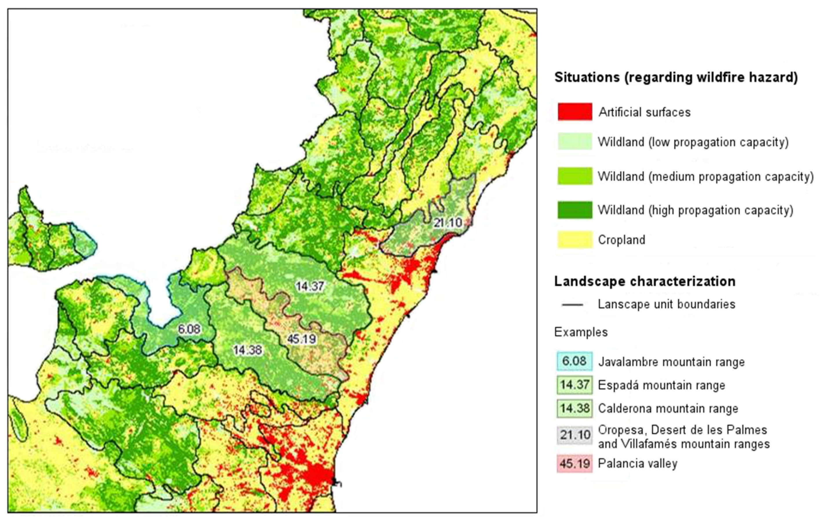
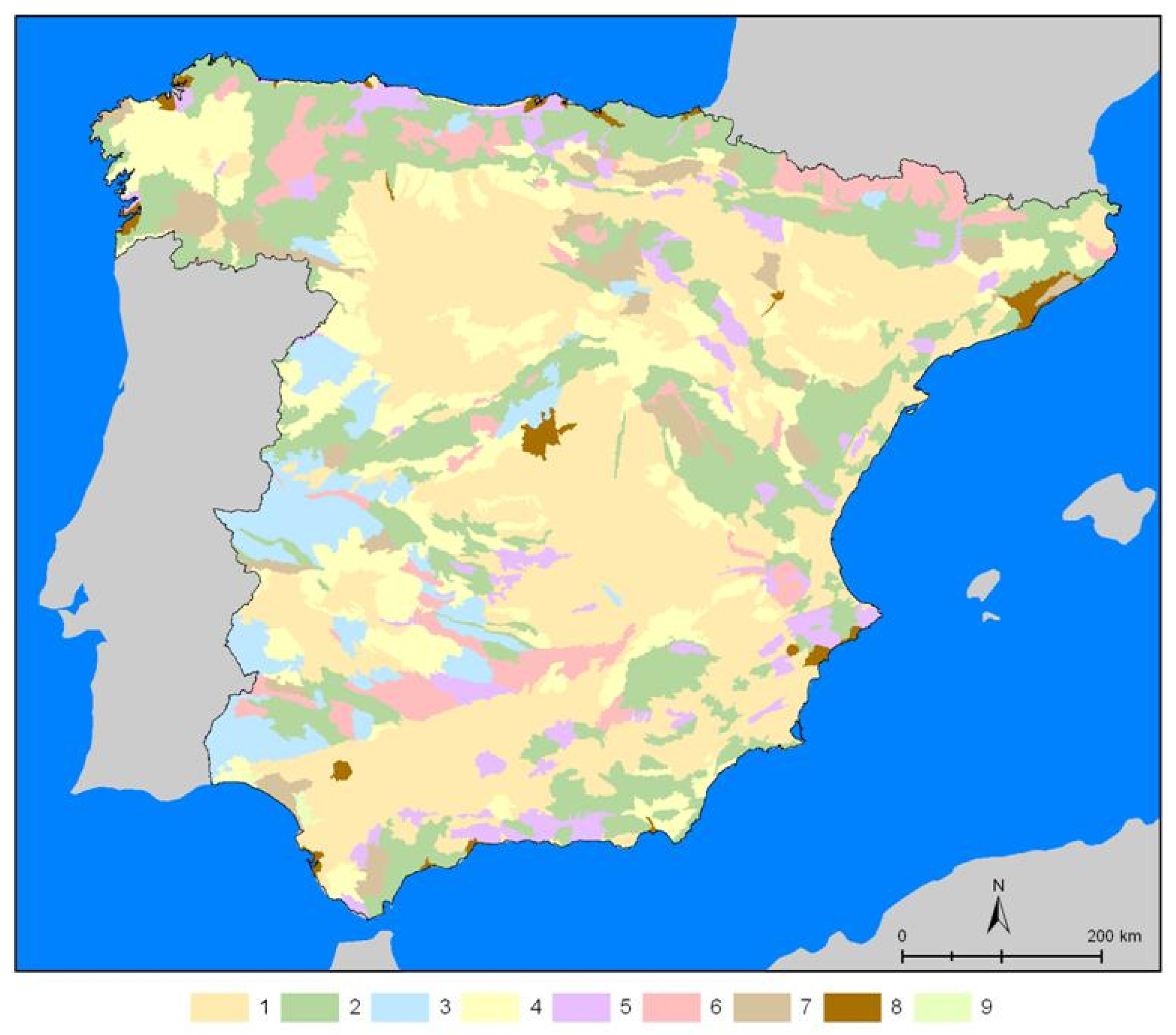
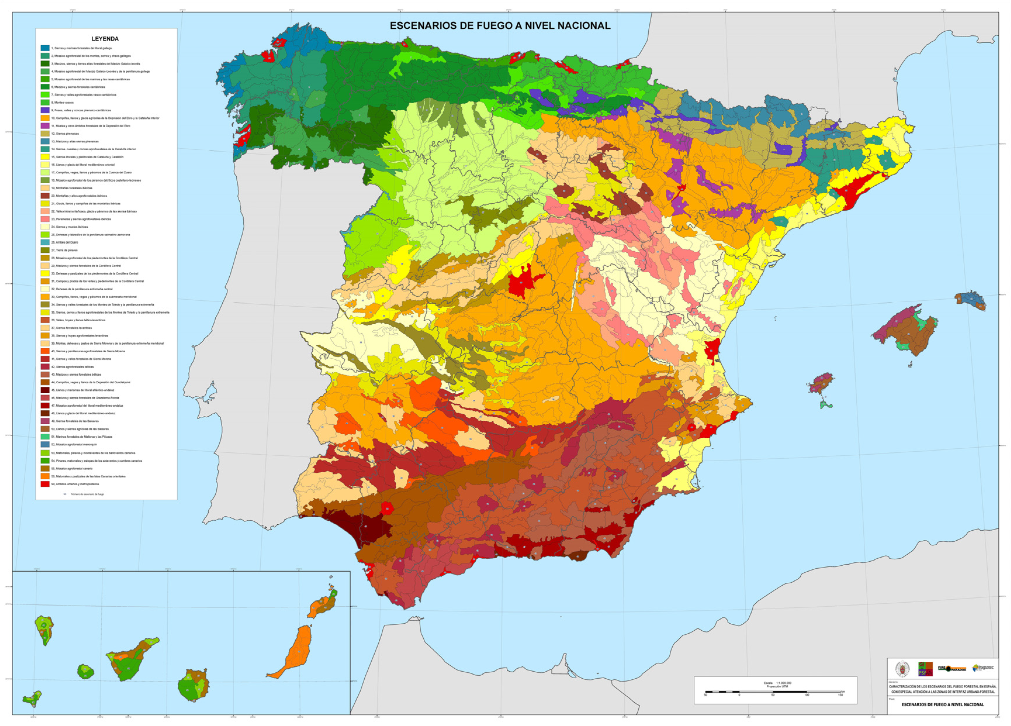
3.2. Mapping and Characterization of National Fire Scenarios in Spain

The national scenarios are based on the most relevant structural characteristics of fire behavior (in relation to the forest ecosystem and settlement system). One of the main outputs of this research is a national-scale map (Figure 4) obtained by applying the methodology described. The 56 fire scenarios identified in Spain at a national level should enable standardization of wildfire protection management in Spain in the different spatial areas defined, setting guidelines for action in accordance with the priorities of prevention, detection and suppression of wildfires.
A file has been produced for each of the fire scenarios identified, summarizing information on the landscape (location, extension and geographical description; physiography and relief; vegetation cover; population) and the corresponding guidelines for proactive fire management including aims and methods of prevention and detection and suppression measures.

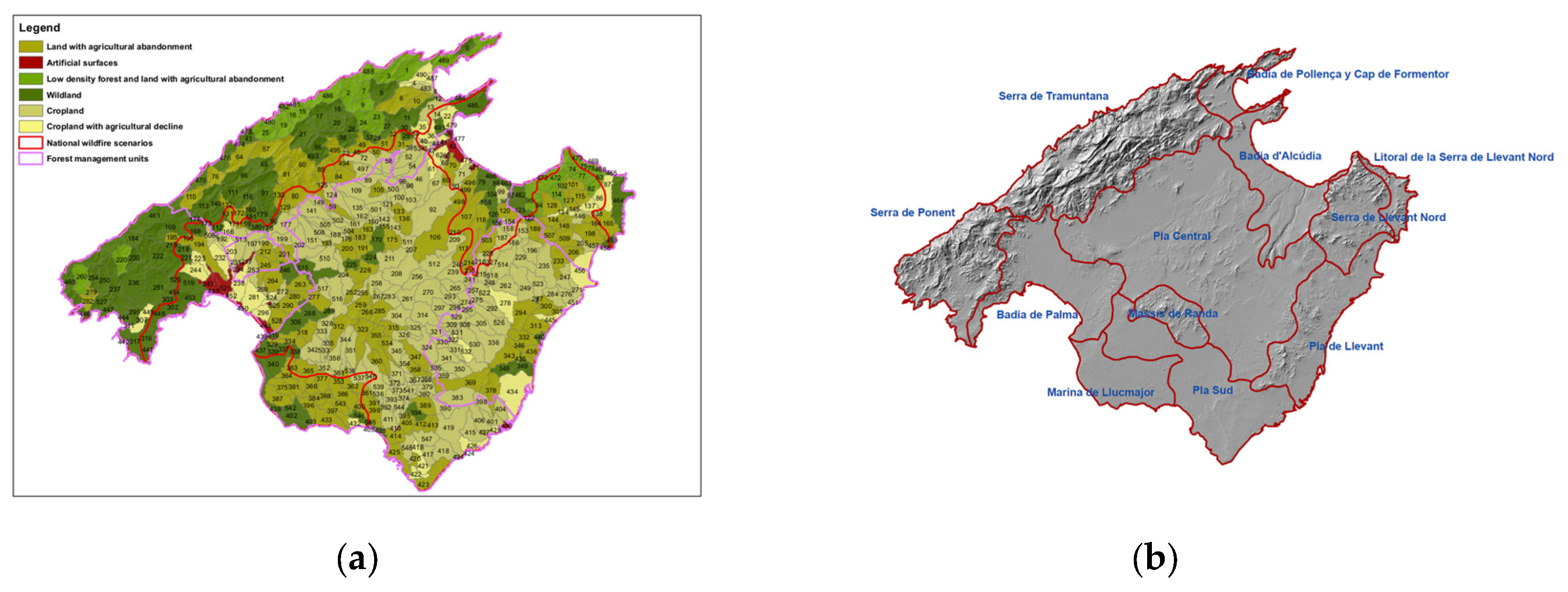
3.3. Testing the Methodology for Identifying the Regional Fire Scenarios: Case Study—The Island of Mallorca

Defining fire scenarios at a regional level starts from the national scenarios and incorporates an assessment of foreseeable local landscape change, following a pattern of use and management, into the structural characterization of each area. These areas display homogeneous physical and landscape characteristics that can be linked to a specific phase of territorial dynamics (vegetation cover and land use) and that correspond to a particular fire generation.
Regional fire scenarios are defined on a more detailed scale (1:50,000) than national scenarios (1:1,000,000), using drainage basin units and forest management units as the spatial references for carrying out a qualitative assessment of the foreseeable landscape dynamics (from interpretation of territorial diagnostic maps) and their impact on wildfire propagation conditions. In each region, characterization of fire scenarios is carried out in accordance with the concept of fire generation and follows common categories, adapted to the landscape structures and dynamics of each specific regional context.
Mallorca, in the Balearic Islands, is used as a case-study. Current territorial dynamics on this island are creating higher levels of vulnerability, associated with the frequency and severity of LWFs. These dynamics are mainly the result of the (a) abandoning of traditional agriculture, (b) loss of forest management capacity and (c) expansion of urban tourism developments. Different stages in this trajectory of increasing vulnerability can be observed in several homogenous areas formed by grouping drainage basins which display similar fire propagation patterns, with different wildfire generations, enabling the definition of different fire scenarios (Figure 5).
A descriptive and operational file has also been produced for each of the regional fire scenarios obtained. This includes descriptive information about the main landscape dynamics of each delimited area, and the strategies adapted to them which will facilitate pre-suppression measures to reduce local vulnerability to fire risk.

4. Discussion

Fire scenarios, defined as spatial areas with common characteristics of ignition, propagation and consequences of wildfires, may be demarcated on various territorial scales. In a small-scale approach (1:1,000,000), the spatial attributes used aim to reflect the structural elements that condition wildfire propagation (forest land hazard, relief) and the gravity and difficulty of their extinction (impact on populated areas). In turn, a larger-scale, regional approach (1:50,000), provides more detail and allows a deeper perception than this initial structural characterization of the territory, including foreseeable dynamics of land use and land cover, linked to future fire behavior. In order to establish the correspondence between territorial dynamics and fire behavior, a model defining various evolutionary stages of the landscape (wildfire generations) is proposed, envisaging the characteristics of wildfires that could occur in the most risk-prone areas (LWFs).
These exercises of zoning and characterizing the territory require special spatial units to analyze the variability of attributes previously defined as relevant to wildfires, both structurally and dynamically. Using landscape units obtained from landscape character assessments has proved to be most appropriate for a smaller scale approach. For a larger scale approach, drainage basins are easy to define (using GIS and terrain models) and easy to group depending on the working scale.
The definition of scenarios at various scales is directly related to the requirements of the territorial and wildfire policies defined by the relevant authorities at different levels. In Spain, the regional authorities (Autonomous Communities) are normally responsible for these policies, but the central (National) government is responsible for inter-regional coordination of wildfire protection activities.
Within this context, national scenarios correspond to central government authority and ensure a national operational approach to the coordination of relevant activities: support for extinction services, protocols for inter-regional cooperation, etc. The main uses and potential end-users of these results (mapping, descriptive files and guidelines for proactive fire management) highlight opportunities for inter-sectorial and inter-territorial coordination in the main efforts to protecta gainst forest fires. In particular, these include: (i) establishing protocols for inter-regional cooperation in similar scenarios; (ii) preparing nationwide plans for civil protection; (iii) theoretical and practical training in risk management and emergencies, including training for the managers and staff of the fire-fighting services.
Regional scenarios are more relevant in terms of direct management, given that the regional authorities are mainly responsible for fighting wildfires. These spatial areas may be useful when defining policies including: developing regulation and planning; regulating land use that may cause wildfires; defining wildland-urban interfaces at risk of wildfire; organizing and coordinating extinction provision and civil protection; and promoting programs to raise awareness.
Nevertheless, a more useful operational tool would be fire scenarios defined on a local scale from a historical analysis of wildfires, implementing the “fire type” concept, which entails a more profound consideration of the interaction between fire prone synoptic situations / topography/ land uses that overwhelm suppression capacity in each area (Table 8).

5. Conclusions

Fire scenarios are a tool for integrating fire management and land use planning to reduce the vulnerability of territories and societies [43]. This is a new concept for living with fire by building up resilient landscapes, adapted communities and proactive policies to address problems of vulnerability.
Fire scenarios in Spain refer to distinct spatial contexts, i.e., to the stage or landscape where different factors are at work. Therefore, the characterization of these complex fire-prone areas is urgently needed in order to adapt fire policies and management systems to current challenges of preparedness (recommendations and guidelines for fire hazard mitigation and protection of resources on a landscape scale) and for governance of uncertainty (integrative and participatory management systems for proactive efficiency in addressing community vulnerability problems and ecosystem services goals).
This innovative approach to fire management provides arguments for adapting land use and forestry practices to the changing fire hazard. In addition, it opens up new avenues to reduce the vulnerability of forest ecosystems and local populations faced with LWFs by identifying fire suppression opportunities and management priority areas.

Acknowledgments

This article is mainly based on research undertaken in the context of the FIRE PARADOX project (6th Framework Programme), the MedWildFireLab project (ERANET-FORESTERRA, 7th Framework Programme), and the FIRESCAPE project, funded by the European Commission and the Ministerio de Economía y Competividad (Spain). The authors benefited from a Complutense “del Amo” Scholarship at the UCLA La Kretz Center for California Conservation Science (University of California Los Angeles, UCLA) to discuss the research idea and first results with US experts on the topic. The authors are also grateful to TRAGSATEC, and particularly to Carmen Aragoneses, for the permission to use the Mapa de Poblamientos. We would also like to thank Oskar Karlsson for his valuable technical support in processing the territorial information and preparing the maps.

Author Contributions

Both authors—Cristina Montiel Molina and Luis Galiana Martín— are responsible for all the ideas, methods design, data analysis, results production and paper writing.

Conflicts of Interest

The authors declare no conflict of interest. The founding sponsors had no role in the design of the study; in the collection, analyses, or interpretation of data; in the writing of the manuscript, or in the decision to publish the results.

References

  1. Keeley, J.E; Bond, W.; Bradstock, R.; Pausas, J.; Rundel, P. Fire in Mediterranean Ecosystems; Cambridge University Press: London, UK, 2012. [Google Scholar]
  2. Montiel, C.; Herrero, G. Overview of policies and practices related to fire ignitions. In Towards Integrated Fire Management—Outcomes of the European Project Fire Paradox; Silva, S.J., Rego, F., Fernandes, P., Rigolot, E., Eds.; European Forest Institute: Joensuu, Finland, 2010; pp. 35–46. [Google Scholar]
  3. National Wildfire Coordinating Group. Glossary of Wildland Fire Terminology. 2015. Available online: http://www.nwcg.gov/glossary-of-wildland-fire-terminology (accessed on 27 September 2016). [Google Scholar]
  4. Viedma, O.; Moity, N.; Moreno, J.M. Changes in landscape fire-hazard during the second half of the 20th century: Agriculture abandonment and the changing role of driving factors. Agric. Ecosyst. Environ. 2015, 217, 126–140. [Google Scholar] [CrossRef]
  5. Syphard, A.D.; Radeloff, V.; Keeley, J.E.; Hawbaker, T.; Clayton, M.; Stewart, S.; Hammer, R. Human influence on California fire regimes. Ecol. Appl. 2007, 17, 1388–1402. [Google Scholar] [CrossRef] [PubMed]
  6. Moritz, M.A.; Batllori, E.; Bradstock, R.A.; Gill, A.M.; Handmer, J.; Hessburg, P.F.; Leonard, J.; McCaffrey, S.; Odion, D.C.; Schoennagel, T.; et al. Learning to coexist with wildfire. Nature 2014, 515, 58–66. [Google Scholar] [CrossRef] [PubMed]
  7. Goldstein, N. Do cities learn from getting burned? In Proceedings of the Artificial Life 7 Workshop, Portland, OR, USA, 1–6 August 2000; Maley, C.C., Boudreau, E., Eds.; pp. 136–138.
  8. Pausas, J.; Keeley, J.E. A burning story: the role of fire in the history of life. BioScience 2009, 59, 593–601. [Google Scholar] [CrossRef] [Green Version]
  9. Barros, A.; Pereira, J.M.; Moritz, M.A.; Stephens, S. Spatial characterization of wildfire orientation patterns in California. Foresus 2013, 4, 197–217. [Google Scholar] [CrossRef]
  10. Castellnou, M.; Larrañaga, A.; Miralles, M.; Molina, D.M. Wildfire scenario: Learning from experience. In Towards Integrated Fire Management—Outcomes of the European Project Fire Paradox; Silva, S.J., Rego, F., Fernandes, P., Rigolot, E., Eds.; European Forest Institute Research Report 23; European Forest Institute: Joensuu, Finland, 2010; pp. 121–133. [Google Scholar]
  11. Montiel, C.; San Miguel, J. Policy analysis reveals the need for new approaches. In Living with Wildfires: What Science Can Tell Us: A Contribution to the Science-Policy Dialogue; Birot, Y., Ed.; EFI Discussion Paper 15; European Forest Institute: Joensuu, Finland, 2009; pp. 63–67. [Google Scholar]
  12. Reid, K.; Beilin, R. Where’s the fire? Co-constructing bushfire in the everyday landscape. Soc. Nat. Resour. Int. J. 2014, 27, 140–154. [Google Scholar] [CrossRef]
  13. Castellnou, M.; Miralles, M.; Pages, J.; Pique, M. Tipificación de los incendios forestales de Cataluña. Elaboración del mapa de incendios de diseño como herramienta para la gestión forestal. In Proceedings of the 5th Congreso Forestal Español, Ávila, Spain, 21–25 September 2009.
  14. Countryman, C. The Fire Environment Concept; U.S. Department of Agriculture, Forest Service: Berkeley, CA, USA, 1972.
  15. Raphael, M.; Hessburg, P.F.; Lehmkuhl, H. Assessing the Compatibility of Fuel Treatments, Wildfire Risk and Conservation of Northern Spotted Owl Habitats and Populations in the Eastern Cascades: A Multiscale Analysis; Final Report; JFSP Project 09-1-08-31; University of Nebraska—Lincoln: Lincoln, NE, USA, 2013. [Google Scholar]
  16. Kruger, T.; Beilin, R. A “responsibility for place”—Firefighter deployment, local knowledge and risk. Int. J. Wildland Fire 2014, 23, 577–584. [Google Scholar] [CrossRef]
  17. Miller, J.D.; Collins, B.M.; Lutz, J.A.; Stephens, S.L.; van Wagtendonk, J.W.; Yasuda, D.A. Differences in wildfires among ecoregions and land management agencies in the Sierra Nevada region, California. Ecosphere 2012, 3, 1–20. [Google Scholar] [CrossRef]
  18. Turner, M.; Donato, D.; Romme, W. Consequences of spatial heterogeneity for ecosystem services in changing forest landscapes: Priorities for future research. Landsc. Ecol. 2013, 28, 1081–1097. [Google Scholar] [CrossRef]
  19. Discroll, D.A.; Bodea, M.; Bradstockd, R.A.; Keithe, D.A.; Penmand, T.D.; Priced, O.F. Resolving future fire management conflicts using multi-criteria decision making. Conserv. Biol. 2015, 30, 196–205. [Google Scholar]
  20. Beilin, R.; Reid, K. It’s not a “thing” but a “place”: Reconceptualising “assets” in the context of fire risk landscapes. Int. J. Wildland Fire 2015, 24, 130–137. [Google Scholar] [CrossRef]
  21. Collins, B.; Stephens, S.; Roller, G.; Battles, J. Simulating fire and forest dynamics for a landscape fuel treatment project in the Sierra Nevada. For. Sci. 2011, 57, 77–88. [Google Scholar]
  22. Linnell, J.; Kaczensky, P.; Wotschikowsky, N.; Lescureux, N.; Boitani, L. Framming the relationship between people and nature in the context of European conservation. Conserv. Biol. 2015, 29, 978–985. [Google Scholar] [CrossRef] [PubMed]
  23. Mermoz, M.; Kitzberger, T.; Veblen, T.T. Landscape influences on occurrence and spread of wildfires in Patagonian forests and shrublands. Ecology 2005, 86, 2705–2715. [Google Scholar] [CrossRef]
  24. Stephens, S.L.; McIver, J.D.; Boerner, R.E.J.; Fettig, C.J.; Fontaine, J.B.; Hartsough, B.R.; Kennedy, P.L.; Schwilk, D.W. The effects of forest fuel-reduction treatments in the United States. Biosciences 2012, 62, 549–560. [Google Scholar]
  25. Chuvieco, E.; Aguado, I.; Jurdao, S.; Pettinari, M.L.; Yebra, M.; Salas, J.; Echeverría, M. Integrating geospatial information into fire risk assessment. Int. J. Wildland Fire 2014, 23, 606–619. [Google Scholar] [CrossRef]
  26. Rodrigues, M.; De la Riva, J.; Fotheringham, S. Modeling the spatial variation of the explanatory factors of human-caused wildfires in Spain using geographically weighted logistic regression. Appl. Geogr. 2014, 48, 52–63. [Google Scholar] [CrossRef]
  27. Román, M.V.; Azqueta, D.; Rodrígues, M. Methodological approach to assess the socio-economic vulnerability to wildfires in Spain. For. Ecol. Manag. 2013, 294, 158–165. [Google Scholar] [CrossRef]
  28. Galiana, L.; Aragoneses, C.; Montiel, C.; de la Cita, J.; Fernández, M. Caracterización de los escenarios del fuego en España. In Proceedings of the 5th Congreso Forestal Español, Ávila, Spain, 21–25 September 2009.
  29. Galiana, L.; Montiel, C. Landscape changes and wildfire behavior: New fire scenarios in Spain. In Proceedings of the 5th International Wildland Fire Conference, Sun City, South Africa, 9–13 May 2011.
  30. Costa, P.; Castellnou, M.; Larrañaga, A.; Miralles, M.; Kraus, D. Prevention of Large Wildfires Using the Fire Types Concept; GRAF-Pau Costa Foundation: Barcelona, Spain, 2011. [Google Scholar]
  31. Wu, J. Effects of changing scale on landscape pattern analysis: Scaling relations. Landsc. Ecol. 2004, 19, 125–138. [Google Scholar] [CrossRef]
  32. Rothermel, R.C. How to Predict the Spreads and Intensity of Forest and Range Forest Fires; U.S. Department of Agriculture, Forest Service: Ogden, UT, USA, 1983.
  33. Elvira, L.; Hernando, C. Inflamabilidad y Energı́a de Las Especies de Sotobosque; Instituto Nacional de Investigaciones Agrarias, Ministerio de Agricultura, Pesca y Alimentación: Madrid, Spain, 1989.
  34. Swanwick, C. Landscape Character Assessment: Guidance for England and Scotland; Countryside Agency and Scottish Natural Heritage: Wetherby, UK, 2002.
  35. Mata, R.; Sanz, C.; Gómez, J.; Allende, F.; López, N.; Molina, P.; Galiana, L. Atlas de Los Paisajes de España; Ministerio de Medio Ambiente: Madrid, Spain, 2003.
  36. Martínez-de-Pisón, E.; Molina-Holgado, P. Diversidad del paisaje natural. In La Diversidad Biológica de España; Pineda, F.D., Ed.; Prentice Hall: Madrid, Spain, 2002; pp. 33–44. [Google Scholar]
  37. Rifà, A.; Castellnou, M. El modelo de extinción de incendios forestales catalán. In Proceedings of the 4th International Wildfire Conference, Sevilla, Spain, 13–18 May 2007.
  38. Castellnou, M. Nuevas metodologías de prevención de grandes incendios. In Proceedings of the Congreso Forestal Ibérico, Castelo Branco, Portugal, 17–19 December 2000.
  39. Bahro, B.; Barber, K.H.; Sherlock, J.W.; Yasuda, D.A. Stewardship and fireshed assessment: A process for designing a landscape fuel treatment strategy. Restoring fireadapted ecosystems. In Proceedings of the National Silviculture Workshop: Restoring Fire Adapted Ecosystems, Tahoe City, CA, USA, 6–10 June 2005; Powers, R.F., Ed.; PSW-GTR-203. U.S. Department of Agriculture, Forest Service, Pacific Southwest Research Station: Albany, CA, USA, 2005; pp. 41–54. [Google Scholar]
  40. Sharples, J.; Gill, M.; Dold, J. The trench effect and eruptive wildfires: Lessons from the King’s Cross Underground disaster. In Proceedings of AFAC 2010 Conference, Darwin, Australia, 8–10 September 2010.
  41. Valese, E.; Conedera, M.; Held, A.C.; Ascoli, D. Fire, humans and landscape in the European Alpine region during the Holocene. Anthropocene 2014, 6, 63–74. [Google Scholar] [CrossRef]
  42. Safford, H.D.; Van De Water, K.M. Using Fire Return Interval Departure (FRID) Analysis to Map Spatial and Temporal Changes in Fire Frequency on National Forest Lands in California; Research Paper PSW-RP-266; U.S. Department of Agriculture, Forest Service, Pacific Southwest Research Station: Albany, CA, USA, 2014.
  43. Galiana, L.; Karlsson, O. Development of a methodology for the assessment of vulnerability related to wildland fires using a multicriteria evaluation. Geogr. Res. 2012, 50, 304–319. [Google Scholar] [CrossRef]
Figure 1. Example overlay of hazard situations on wildfire hazard and landscape characterization (Valencia region).
Forests 07 00273 g001
Figure 2. Spatial distribution of the 9 groups with similar distribution of wildfire hazard in peninsular Spain.
Forests 07 00273 g002
Figure 3. Methodological process for identifying regional fire scenarios.
Forests 07 00273 g003
Figure 4. Fire scenarios in Spain on a national scale.
Forests 07 00273 g004
Figure 5. (a) Territorial dynamics linked to wildfire generations on the island of Mallorca; (b) Map of regional fire scenarios.
Forests 07 00273 g005
Table 1. Settlement types.
Settlement TypesDescription
Urban environmentUrban areas of more than 50 ha
Settlement in forest areaUrban nuclei of 1–50 ha or more than 5 urban nuclei of under 1 ha in a 25 m buffer zone. More than 30% of the surrounding surface area (forest and agricultural) in a 1 m buffer zone is forest.
Settlement in agricultural areaUrban nuclei of 1–50 ha, or more than 5 urban nuclei of under 1 ha in a 25 m buffer zone. Less than 30% of the surrounding surface area (forest and agricultural) is forest in a 1 m buffer zone.
Scattered buildings in forest area3–5 urban nuclei of under 1 ha in a 100 m buffer zone. More than 30% of the surrounding surface area (forest and agricultural) in a 1 m buffer zone is forest.
Scattered buildings in agricultural area3–5 urban nuclei of under 1 ha in a 100 m buffer zone. Less than 30% of the surrounding surface area (forest and agricultural) in a 1 m buffer zone is forest.
Isolated buildings in forest area1 or 2 urban nuclei of less than 1 ha in a 100 buffer zone. More than 30% of the surrounding surface area (forest and agricultural) in a 1 m buffer zone, is forest.
Isolated buildings in agricultural area1 or 2 urban nuclei under 1 ha in a 100 m buffer zone. Less than 30% of the surrounding surface area (forest and agricultural) in a 1 m buffer zone is forest.
Unpopulated forest areaForest area with no urban settlements.
Unpopulated agricultural areaAgricultural area with no urban settlements.
Table 2. Decision matrix for fuel hazard assessment.
Fuel HazardCombustibility
Low CombustibilityMedium and High Combustibility
FlammabilityLow flammabilityPC1 1PC2 2
High flammabilityPC2PC2
1PC1: low risk fuel, characterized by low flammability and combustibility; 2 PC2: medium and high risk fuel, characterized by high combustibility and flammability.
Table 3. Risk associated with slope intervals.
Physiographic HazardSlope Range
Low≤15%
Moderate16%–29%
High≥30%
Table 4. Decision matrix for assessing the intrinsic propensity of a forest system for fire propagation.
SlopeFuel Hazard
LowMedium/High
LowLowMedium
ModerateLowHigh
HighMediumHigh
Table 5. Classification of wildfire generation [13,37].
Wildfire GenerationFuelWildfire CharacteristicsTerritorial and Temporal ContextAction
1st wildfire generationContinuity of forest mass, low fuel load (grassland, meadows).Long perimeters and high propagation speed.Started in the late 1950–1960s, related to abandoned farmland.Local response: increased accessibility to the land; linear prevention infrastructure (firebreaks).
2nd wildfire generationContinuity of forest mass and increased fuel load (scrubland).High intensity and high propagation speed; start of secondary ignition sites.Started in the late 1970–1980s due to abandoning of farmland and traditional forest management.Reduced access time (tracks, quick detection, forceful attack, water spots).
3rd wildfire generationHomogeneous forests with high densities and vertical continuity.Crown fires that overwhelm the tactical intervention capacity; multiple secondary ignition sites (advances jumping long distances). Large wildfires, more than 20,000 to 30,000 ha.Prolonged lack of forest management (30–50 years); extinction of all low- and middle-intensity wildfires.Extinction task forces admit their limits. Use of all extinction techniques. Strategic response: promotion of forest management and prescribed burnings; promotion of self-protection in estates; advance of opportunities (confinement and deceleration); more dynamic and flexible decision-making.
4th wildfire generationSame as 3rd + estates with propagation capacity.Same as 3rd (LWFs) + creation of multiple emergencies (in wildland-urban interfaces (WUI).Same as 3rd + increase of scattered estates in forest land.Same as 3rd + differentiation between strategic and tactical levels; decision making at lower levels.
5th wildfire generationSame as 4th.Same as 4th + simultaneity.Same as 4th.Same as 4th.
Table 6. Attribute and data selection for determining the stage of wildfire generations.
Defining ElementsIntervening FactorsSources of Information
Propagation capacityFuel load and continuity
Slope
Cartography of fuel models (Forest Map)
Digital Terrain Model (DTM)
Wildfire characteristicsIntensity, propagation speed, simultaneity
Burned area
Wildfire database
Wildfire perimeters
Territorial contextAgricultural abandonment
Intensity of forest management
Presence of wildland-urban interface (WUI)
Crops and land use map
National Forest Inventory
Settlement Map (TRAGSATEC)
Table 7. Drivers of fire propagation patterns.
Driving ForcesTrends and Fire Behavior Effects
Ecosystem transition (from grass-fueled to woody-fueled fires)In non-forested landscapes:
Expansion of grass-dominated ecosystems, as a result of agricultural abandonment (higher fire spread: 1st generation of wildland fires)
Increase in understory fuels in open forests, as a result of grazing abandonment (higher fire intensity: 2nd generation of wildland fires)
In forested landscapes:
Increase of shrubland (regeneration of natural vegetation) and development of complex forest ecosystems: increase of fuel load and vertical continuity, as a result of land management abandonment (convective fire-type: 3rd generation)
Increase of landscape fuel connectivityHomogenous surfaces of the same fuel model after traditional landscape mosaic disappears (larger fire perimeters: 1st generation).
Urban sprawlDevelopment of WUI (higher fuel complexity: 4th generation
Large and complex urban regions characterized as high risk areas with extremely rapid, virulent fire behavior (simultaneous large wildfires; megafires; 5th generation)
Table 8. Multi-scale, inter-sectorial approach for integsrated wildfire risk management in different territorial scenarios.
ScaleCriteria for Definition of Fire ScenariosApplied to Planning: Spatial Planning and Rural Development PoliciesApplied to Planning : Wildland Fire and Civil Protection Policies
National (1:1,000,000)General landscape configuration (relief and vegetation cover)
Interaction between type of vegetation cover and settlement system.
Characterize and differentiate land areas with regard to fires to enable different region-specific actions.
Basis for establishing land development policies including fire risk management.
Establish homogeneous fire prevention and extinction policies in large regional areas.
Regional (1:200,000–1:50,000)Landscape patterns
Trends in landscape changes
Fire regime
More rational territorial model: to reduce settlement system vulnerability from proliferation of scattered settlements (WUI).
Link major decisions on land use to fire regimes.
Spatial basis for appropriate zoning for forest and fire management.
Local (1:25,000)Definition of fire types (interaction of synoptic situations/topography/vegetation type) prone to develop into LWFs in each areaRisk maps: mandatory basis for detailed zoning by use.
Management strategies to reduce vulnerability to specific hazards (damage mitigation).
Establish management requirements for specific propagation modes.
Pre-extinction actions (defence opportunities; reduction of propagation rate).
Mapping of suppression opportunities and priorities.
Involvement of general public in fire-related forest management.

