
Recent Afforestation in the Iowa River and Vorskla River Basins: A Comparative Trends Analysis

 , ,
, ,
Abstract
:1. Introduction
2. Materials and Methods
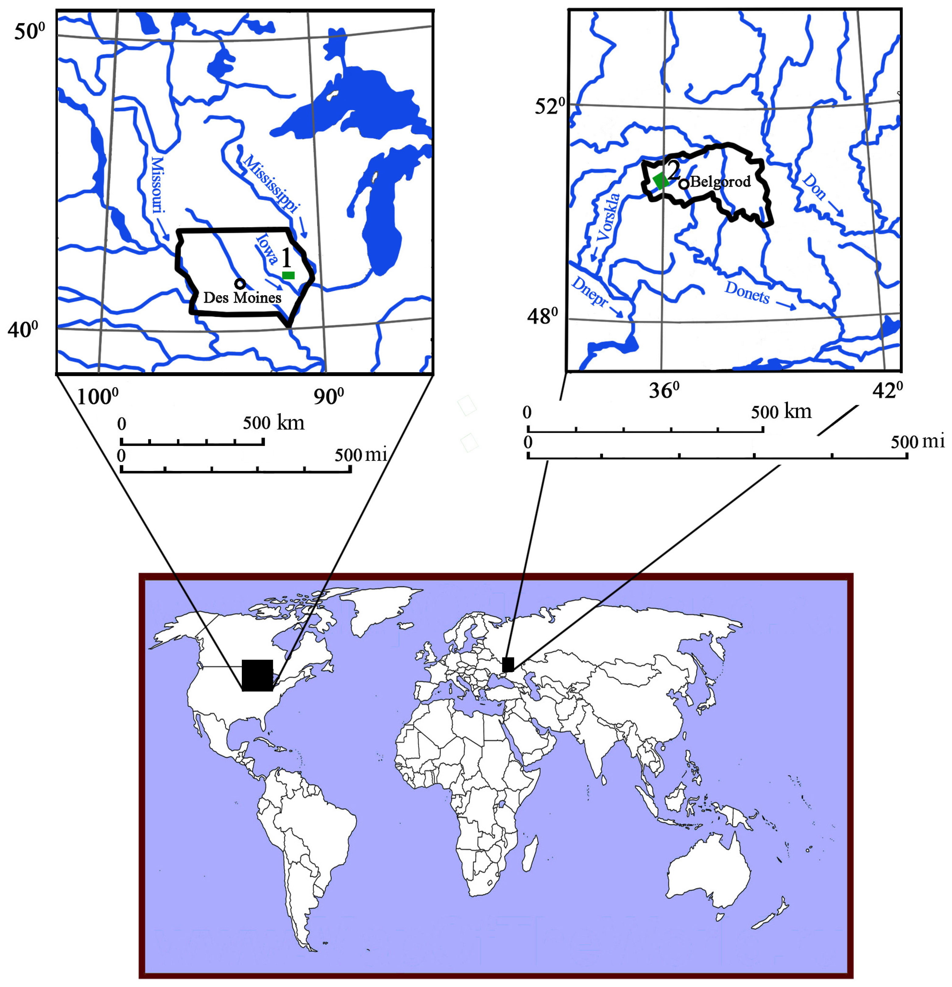
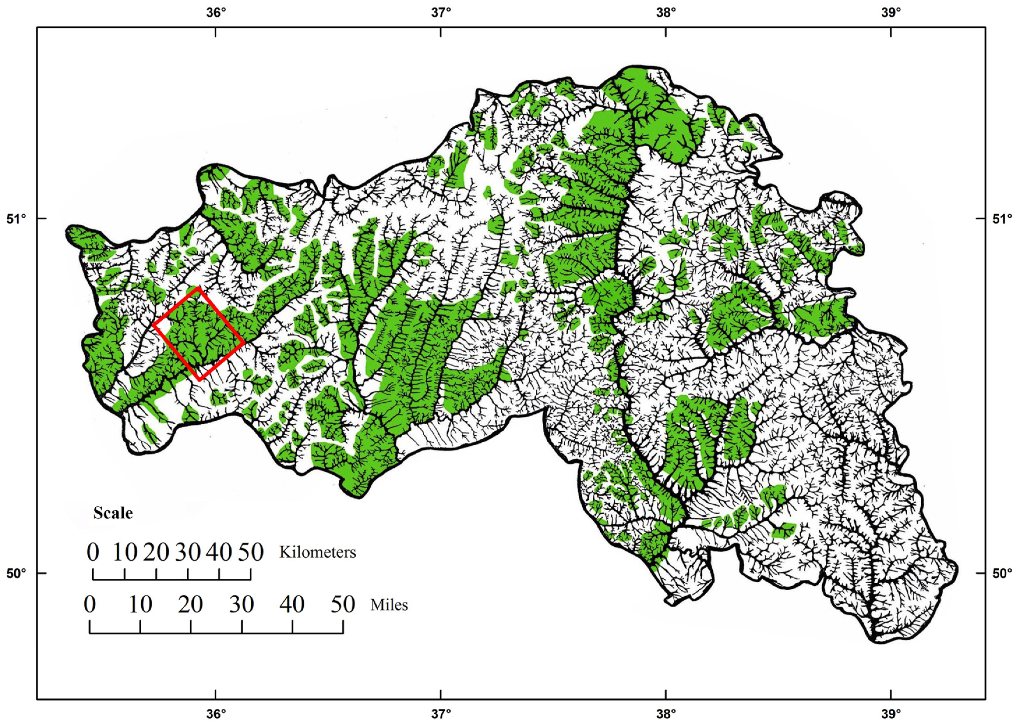
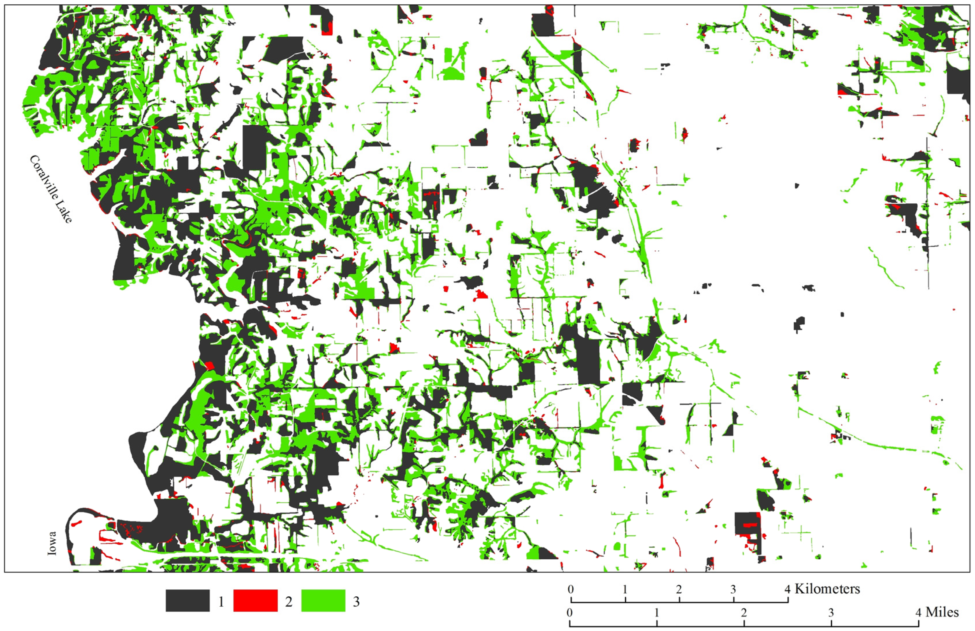
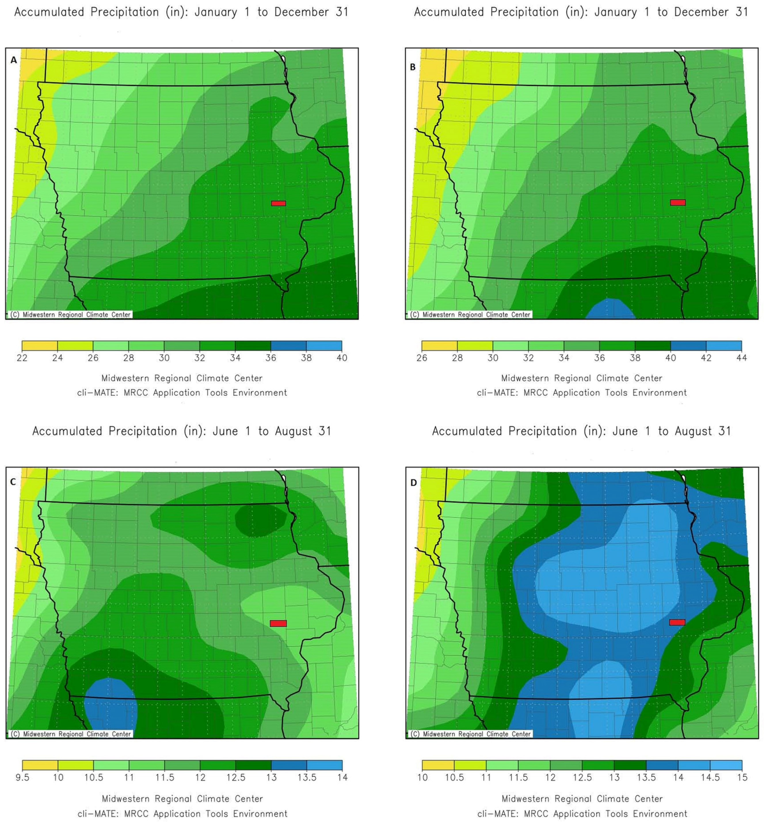
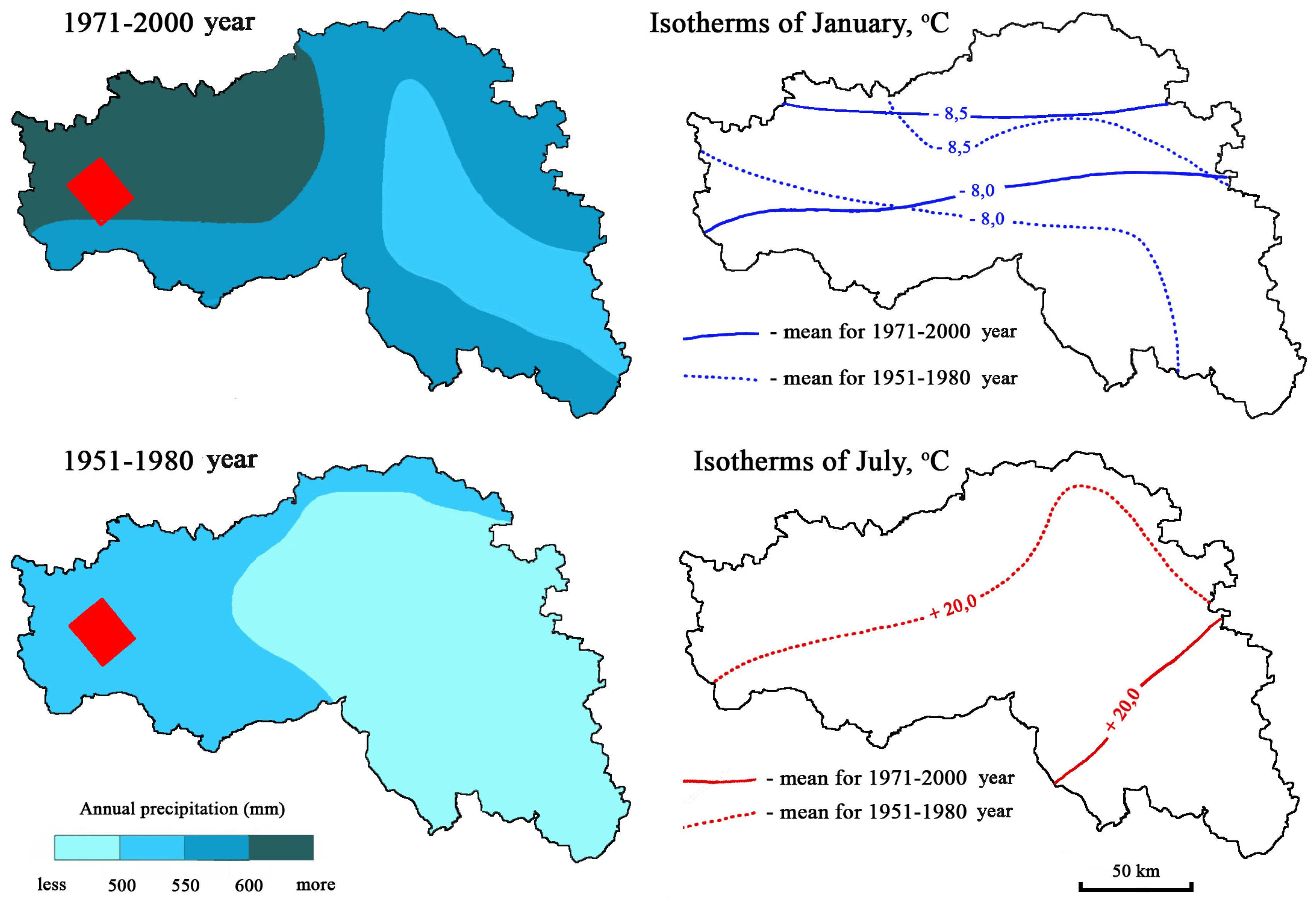
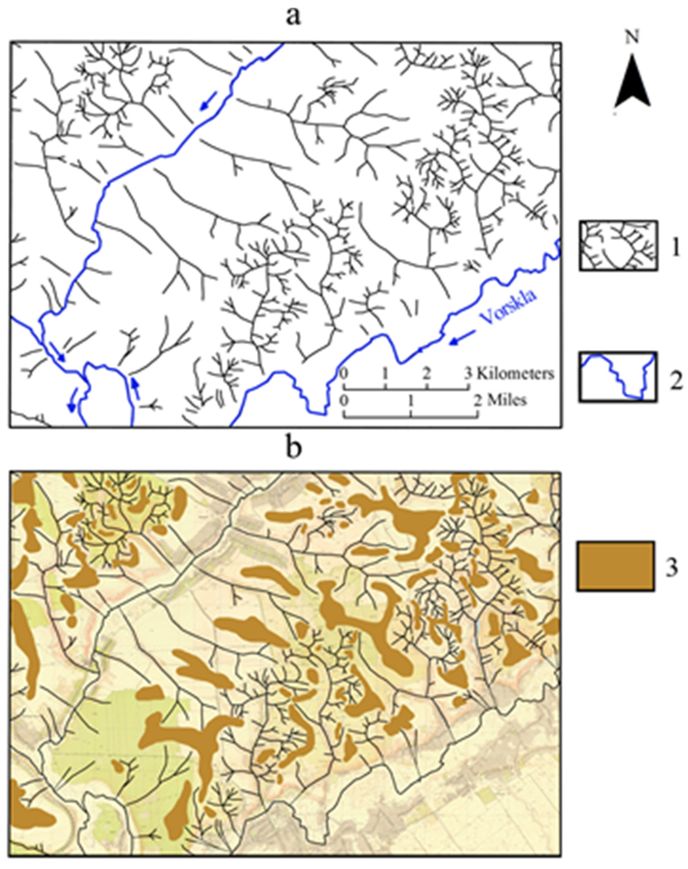
2.1. Study Regions
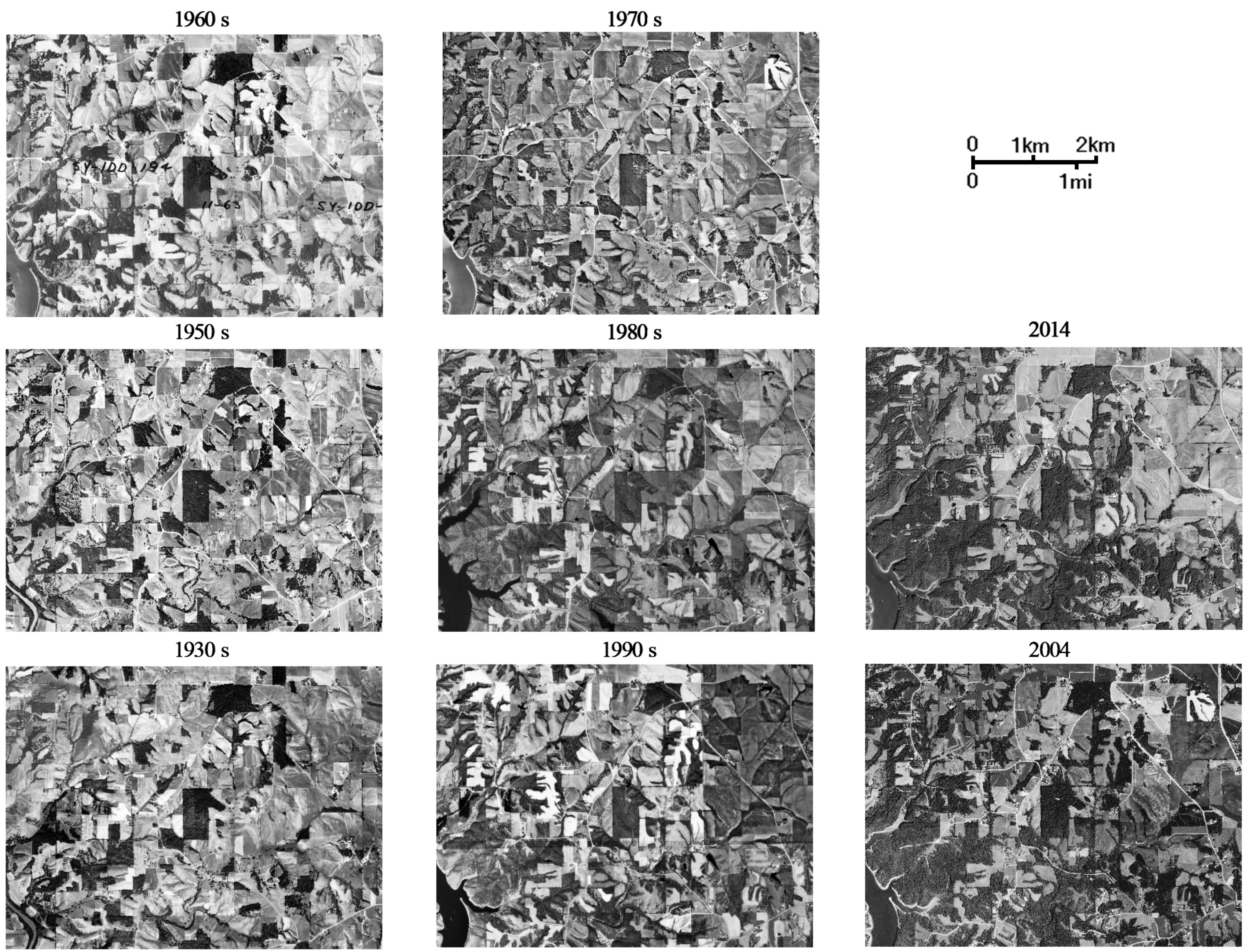
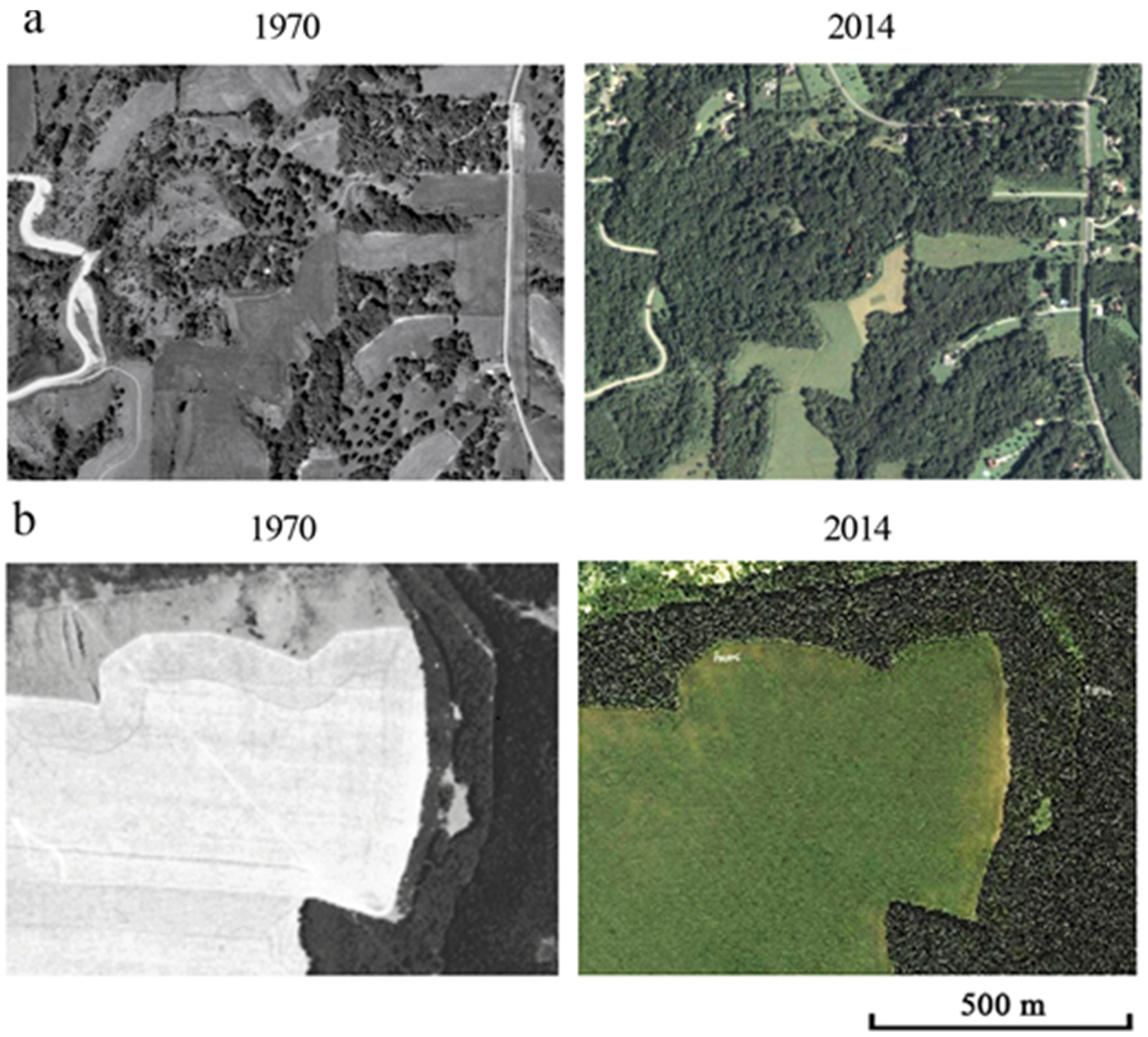
2.2. Orthophotographs
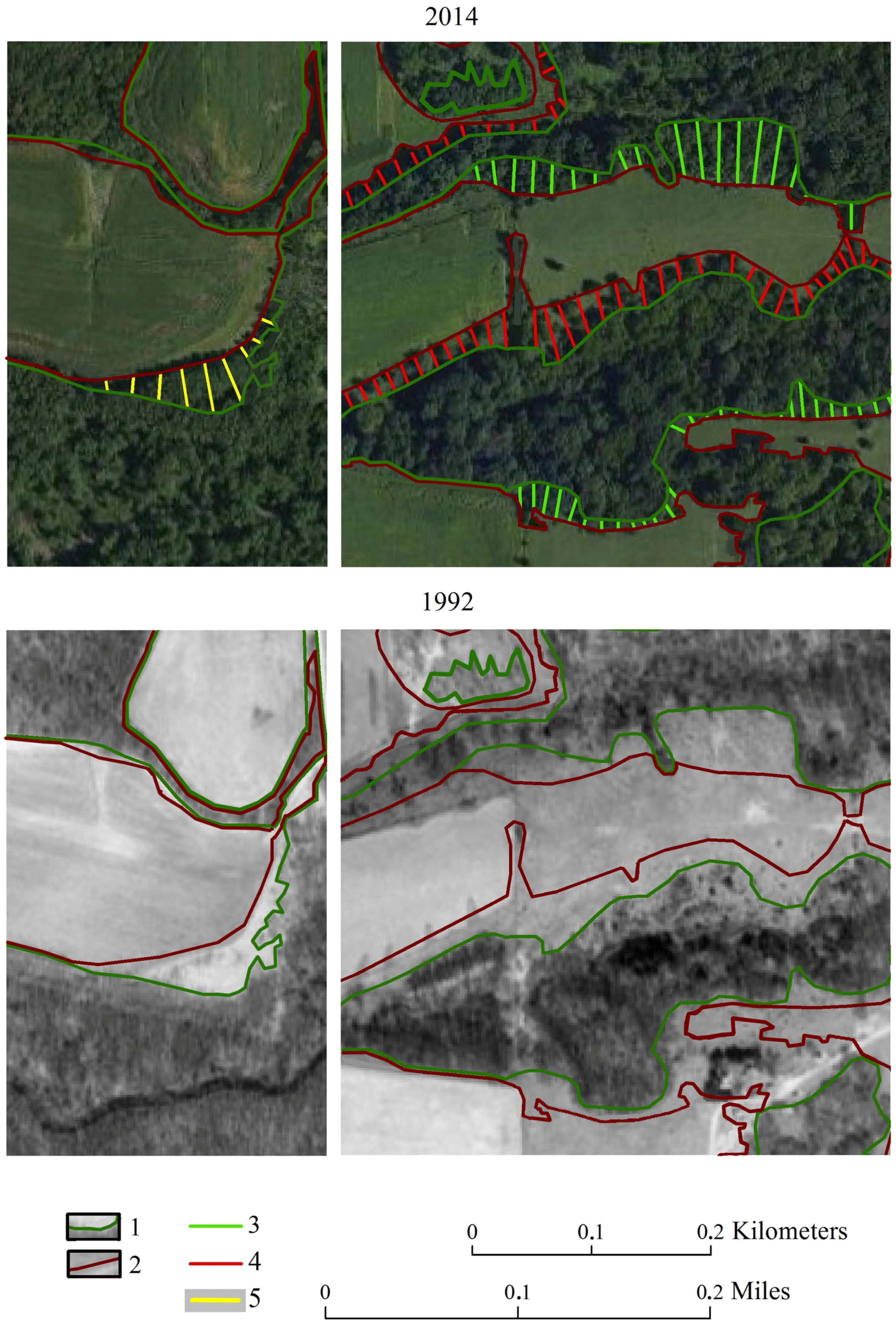
2.3. Data Analysis
3. Results
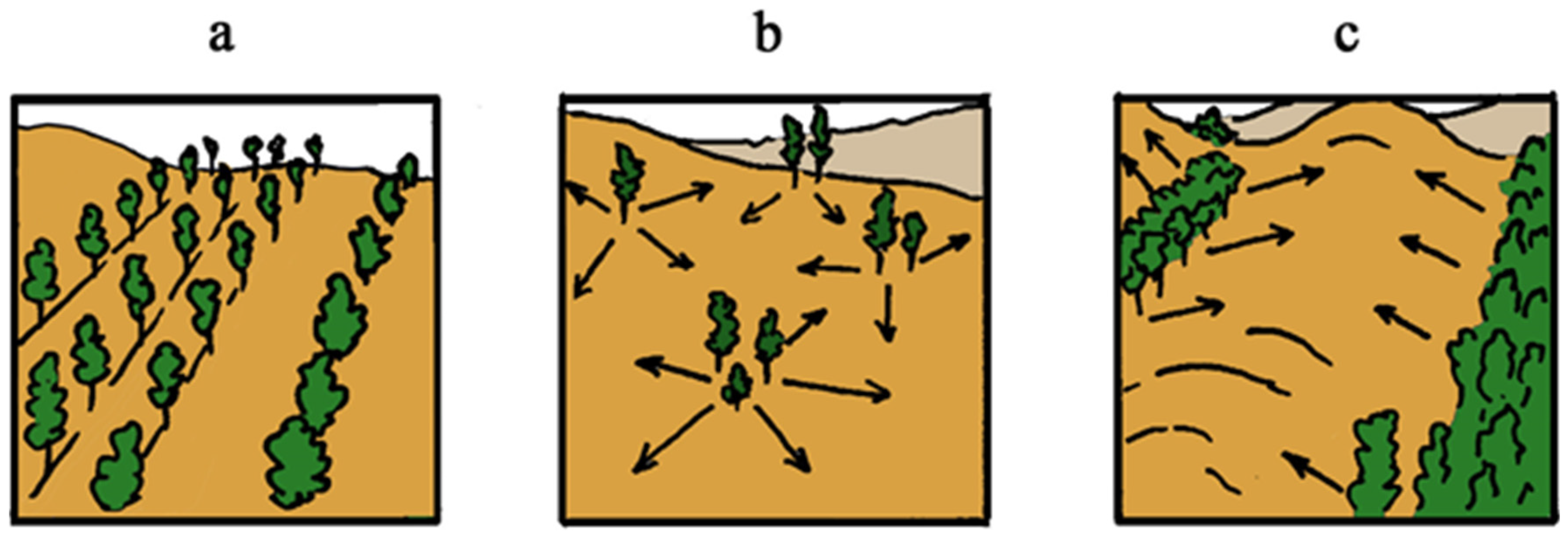
4. Discussion
5. Conclusions
Acknowledgments
Author Contributions
Conflicts of Interest
References
- Laurance, W.F. The Politics of Conservation: Using International Carbon Trading to Protect Forests and Biodiversity. Soc. Altern. 2010, 29, 20–24. [Google Scholar]
- Intergovernmental Panel on Climate Change (IPCC). Climate Change 2014: Impacts, Adaptation, and Vulnerability, Contribution of Working Group II to the Fifth Assessment Report of the Intergovernmental Panel on Climate Change. 2014. Available online: http://www.ipcc.ch (accessed on 15 March 2016).
- The National Climate Assessment (NCA). The National Climate Assessment Summarizes the Impacts of Climate Change on the United States, Now and in the Future. 2014. Available online: http://nca2014.globalchange.gov/ (accessed on 15 March 2016). [Google Scholar]
- Chendev, Y.G.; Sauer, T.J.; Gennadiev, A.N.; Novykh, L.L.; Petin, A.N.; Petina, V.I.; Zazdravnykh, E.A.; Burras, C.L. Accumulation of Organic Carbon in Chernozems (Mollisols) under Shelterbelts in Russia and the United States. Eurasian Soil Sci. 2015, 48, 43–53. [Google Scholar] [CrossRef]
- Knight, C.L.; Briggs, J.M.; Nellis, N.D. Expansion of gallery forest on Konza Prairie research natural area, Kansas, USA. Landsc. Ecol. 1994, 9, 117–125. [Google Scholar]
- Kochy, M.; Wilson, S.D. Nitrogen deposition and forest expansion in the northern great plains. J. Ecol. 2001, 89, 807–817. [Google Scholar] [CrossRef]
- Sauer, T.J.; James, D.E.; Cambardella, C.A.; Hernandez-Ramirez, G. Soil properties following restoration or afforestation of marginal cropland. Plant Soil 2012, 360, 1–2. [Google Scholar] [CrossRef]
- Savin, I.Y. Interpretation of Forest-Steppe Soil Covert within of Central Chernozem Region by Medium-Scale Satellite Images. Ph.D. Thesis, V.V. Docuchaev Soil Science Institute, Moscow, Russia, 1990; p. 300. [Google Scholar]
- Ruhe, R.V.; Sholtes, W.H. Ages and development of soil landscapes in relation to climatic and vegetation changes. Soil Sci. Soc. Proc. 1955, 20, 264–273. [Google Scholar] [CrossRef]
- Denniston, R.F.; Gonzalez, L.A.; Asmerom, Y.; Reagan, M.K.; Recelli-Snyder, H. Speleothem carbon isotopic records of Holocene environments in the Ozark Highlands, USA. Quat. Int. 2000, 67, 21–27. [Google Scholar] [CrossRef]
- Baker, R.G.; Bettis, E.A.; Denniston, R.F.; Gonzalez, L.A.; Strickland, L.E.; Kreig, J.R. Holocene paleoenvironments in southeastern Minnesota chasing the prairie-forest ecozone. Paleogeogr. Paleoclimatol. Paleoecol. 2002, 177, 103–122. [Google Scholar] [CrossRef]
- Chendev, Y.G. Evolution of Forest-Steppe Soils in Central Russian Upland during the Holocene; Geos: Moscow, Russia, 2008; p. 212. [Google Scholar]
- Aleksandrovskii, A.L.; Chendev, Y.G. Climatic Evolution of Soils within Great Plains of the Northern Hemisphere during the Holocene: Climate Change, Soils and Environment. In Proceedings of the International Scientific Seminar, Belgorod, Russia, 16–19 September 2009; pp. 162–169.
- Birk, K.; Lupo, A.R.; Guinan, P.E.; Barbieri, C.E. The interannual variability of Midwestern temperatures and precipitation as related to the ENSO and PDO. Atmofera 2010, 23, 95–128. [Google Scholar]
- Lupo, A.R.; Smith, N.B.; Guinan, P.E.; Chesser, M.D. The climatology of Missouri Region dew points and the relationship to ENSO. Natl. Weather Dig. 2012, 36, 10–20. [Google Scholar]
- Yeh, H.Y.; Wensel, L.C. The relationship between tree diameter growth and climate for coniferous species in Northern California. Can. J. For. Res. 2000, 30, 1463–1471. [Google Scholar] [CrossRef]
- Morales, M.; Villalda, R.; Ricardo-Grau, H.; Paolini, L. Rainfall-controlled tree growth in high-elevation subtropical tree lines. Ecology 2004, 85, 3080–3089. [Google Scholar] [CrossRef]
- Krauss, K.W.; Keeland, B.D.; Allen, J.A.; Ewel, K.C.; Johnson, D.J. Effects of season, rainfall, and hydrogeomorphic setting on mangrove tree growth in Micronesia. Biotropica 2007, 39, 161–170. [Google Scholar] [CrossRef]
- Sazhin, A.N.; Kozina, O.V. Contemporary Climatic Tendencies and Their Reflection at the Regional Level (on Example of Lower Volga Region). In Proceedings of the Scientific Discovery of the Surrounding Nature, The Dynamics of the Georgraphical Environment (Nature, Society, Policy): Transactions of XI Congress of the Russian Geographic Society, Saint-Petersburg, Russia, 2000; Volume 5, pp. 105–106.
- Sedykh, V.N. Using aerial photography and satellite imagery to monitor forest cover in western Siberia. Water Air Soil Pollut. 1995, 82, 499–507. [Google Scholar] [CrossRef]
- Lawrence, R.L.; Ripple, W.J. Calculating Change Curves for Multitemporal Satellite Imagery: Mount St. Helens 1980–1995. Remote Sens. Environ. 1999, 67, 309–319. [Google Scholar] [CrossRef]
- Franklin, S.E.; Lavigne, M.B.; Wulder, M.A.; McCaffrey, T.M. Large-area forest structure change detection: An example. Can. J. Remote Sens. 2002, 28, 588–592. [Google Scholar] [CrossRef]
- Sader, S.A.; Bertrand, M.; Hoffhine-Wilson, E. Satellite change detection of forest harvest patterns on an industrial forest landscape. For. Sci. 2003, 49, 141–153. [Google Scholar]
- Boyd, D.S.; Danson, F.M. Satellite remote sensing of forest resources: three decades of research development. Prog. Phys. Geogr. 2005, 29, 1–26. [Google Scholar] [CrossRef]
- Wulder, M.A.; White, J.C.; Coops, N.C.; Butson, C.R. Multi-temporal analysis of high spatial resolution imagery for disturbance monitoring. Remote Sens. Environ. 2008, 112, 2729–2740. [Google Scholar] [CrossRef]
- Walton, J.T.; Nowak, D.J.; Greenfield, E.J. Assessing Urban Forest Canopy Cover Using Airborne or Satellite Imagery. Arboric. Urban For. 2008, 34, 334–340. [Google Scholar]
- Borrelli, P.; Sandia-Rondon, L.A.; Schutt, B. The use of Landsat imagery to assess large-scale forest cover changes in space and time, minimizing false-positive changes. Appl. Geogr. 2013, 41, 147–157. [Google Scholar] [CrossRef]
- Terekhin, E. The procedure of seeking effective spectral indices for automated interpretation of water bodies (a case study of Belgorod Oblast). Geogr. Nat. Resour. 2013, 34, 272–277. [Google Scholar] [CrossRef]
- Lambrechts, C.; Woodley, D.; Litoroh, M.; Kamwara, P. Aerial Monitoring of Forest Boundaries. Available online: http://www.unep.org/dewa/Portals/67/pdf/Aerial_Monitoring_Report-1-final.pdf (accessed on 2 February 2015.
- Moskal, L.M.; Styers, D.M.; Halabisky, M. Monitoring Urban Tree Cover Using Object Based Image Analysis and Public Domain Remotely Sensed Data. Remote Sens. 2011, 3, 2243–2262. [Google Scholar] [CrossRef]
- Franklin, S.E.; Montgomery, P.K.; Stenhouse, G.B. Interpretation of land cover changes using aerial photography and satellite imagery in the Foothills Model Forest of Alberta. Can. J. Remote Sens. 2005, 31, 304–313. [Google Scholar] [CrossRef]
- Tyukavina, A.; Stehman, S.V.; Potapov, P.V.; Turubanova, S.A.; Baccini, A.; Goetz, S.J.; Laporte, N.T.; Houghton, R.A.; Hansen, M.C. National-scale estimation of gross forest aboveground carbon loss: A case study of the Democratic Republic of the Congo. Environ. Res. Lett. 2013, 8, 1–14. [Google Scholar] [CrossRef]
- Torahi, A.A.; Rai, S.C. Land cover classification and forest change analysis, using satellite imagery—A case study in Dehdez Area of Zagros Mountain in Iran. J. Geogr. Inf. Syst. 2011, 3, 1–11. [Google Scholar] [CrossRef]
- Nori, W.; Elsidding, E.N.; Niemeyer, I. Detection of land cover changes using multi-temporal satellite imagery. Int. Arch. Photogramm. Remote Sens. Spat. Inf. Sci. 2008, 37, 947–951. [Google Scholar]
- Narzary, G.S. Detecting forest cover changes of Kokrajhar District using remote sensing and GIS techniques. OSR J. Environ. Sci. Toxicol. Food Technol. 2013, 1, 43–47. [Google Scholar] [CrossRef]
- Hansen, M.C.; Stehman, S.V.; Potapov, P.V.; Arunarwati, B.; Stolle, F.; Pittman, K. Quantifying changes in the rates of forest clearing in Indonesia from 1990 to 2005 using remotely sensed data sets. Environ. Res. Lett. 2009, 4. [Google Scholar] [CrossRef]
- Iowa Counties Historic Atlases. Combination Atlas Map of Johnson County, Iowa; Thompson and Everts: Geneva, IL, USA, 1870; pp. 1–37. [Google Scholar]
- Soil Conservation Service (SCS). Soil Survey of Johnson County Iowa, 1983; United States Department of Agriculture: Washington, DC, USA, 1983.
- Iowa State Planning Board. Iowa Twenty-Five-Year Conservation Plan; Iowa State Conservation Commission: Des Moines, IA, USA, 1935; pp. 118–119. [Google Scholar]
- Sukachev, V.N. Essay of Vegetation for South-Eastern Section of Kursk Province; Forest Insititute: Saint-Petersburg, Russia, 1903; p. 229. [Google Scholar]
- Chendev, Y.G.; Petin, A.N.; Serikova, E.V.; Kramchaninov, N.N. Degradation of geosystems in the Belgorod region as a result of the economic Activities. Geogr. Nat. Resour. 2008, 4, 69–74. [Google Scholar] [CrossRef]
- Iowa Geographic Map Server (IGMS). Available online: http://ortho.gis.iastate.edu/ (accessed on 6 May 2015).
- EarthExplorer. Available online: http://earthexplorer.usgs.gov (accessed on 28 May 2015).
- ArcGIS World Imagery. Available online: https://www.arcgis.com/home/webscene/viewer.html (accessed on 30 May 2015).
- The Midwest Regional Climate Center (MRCC). Available online: http://mrcc.isws.illinois.edu/ (accessed on 17 February 2015).
- All Russia Research Institute of Hydrometeorological Information-World Data Centre (RIHMI-WDC). Available online: http://meteo.ru/ (accessed on 18 February 2015).
- Holzmueller, E.J.; Gibson, D.J.; Suchecki, P.F. Accelerated succession following an intense wind storm in an oak-dominated forest. For. Ecol. Manag. 2012, 279, 141–146. [Google Scholar] [CrossRef]
- Lazarus, E.D.; McGill, B.J. Pushing the Pace of Tree Species Migration. PLoS ONE 2014, 9, e105380. [Google Scholar] [CrossRef] [PubMed]
- Foote, R.L.; Grogan, P. Soil carbon accumulation during temperate forest succession on abandoned low productivity agricultural lands. Ecosystems 2010, 13, 795–812. [Google Scholar] [CrossRef]
- U.S. Geological Survey. Geographic Names Phase I Data Compilation (1976–1981). Primarily from U.S. Geological Survey 1:24,000-Scale Topographic Maps and from U.S. Board on Geographic Names Files; United States Geological Survey: Reston, VA, USA, 1981.
- Andreas, A.T. Illustrated Historical Atlas of the State of Iowa; Andreas Atlas T. C.: Chicago, IL, USA, 1875; p. 580. [Google Scholar]
- Lomis, W.E.; McKomb, A.L. Recent advances of the Forest in Iowa. Iowa Acad. Sci. 1944, 51, 217–224. [Google Scholar]
- Woodhouse, C.A.; Overpeck, J.T. 2000 Years of Drought Variability in the Central United States. Bull. Am. Meteorol. Soc. 1998, 79, 2693–2714. [Google Scholar] [CrossRef]
- Thompson, J.R. Prairies, Forests and Wetlands: The Restoration of Natural Landscape Communities in Iowa; University of Iowa Press: Iowa City, IA, USA, 1992; p. 140. [Google Scholar]
- Trani, M.K.; Brooks, R.T.; Schmidt, T.L.; Rudis, V.A.; Gabbard, M.C. Patterns and trends of early successional forests in the eastern United States. Wildl. Soc. Bull. 2001, 29, 413–424. [Google Scholar]
- Nowacki, G.J.; Abrams, M.D. The demise of fire and “mesophication” of forest in the eastern United States. BioScience 2008, 58, 123–138. [Google Scholar] [CrossRef]
- Alexandrovsky, A.L.; Chendev, Y.G.; Trubitsin, M.A. Paleo Soil Indicators of Changes in Ecological Conditions in the Central Forest-Steppe in Late Holocene. Izvestiya RAN. Seriya Geogr. 2011, 6, 87–99. [Google Scholar]
- Karl, T.R.; Knight, R.W. Secular trends of precipitation amount, frequency, and intensity in the United States. Bull. Am. Meteorol. Soc. 1998, 79, 231–241. [Google Scholar] [CrossRef]
- Gaffen, D.J.; Ross, R.J. Climatology and trends of U.S. surface humidity and temperature. J. Clim. 1999, 12, 811–828. [Google Scholar] [CrossRef]
- Intergovernmental Panel on Climate Change (IPCC). Climate Change 2013: The Physical Scientific Basis, Contributions of Working Group I to the Fifth Assessment Report of the Intergovernmental Panel on Climate Change. Available online: http://www.ipcc.ch (accessed on 2 February 2015).
- Klukin, N.V. Climatic Map. In Atlas of Belgorod Oblast; GUGK: Moscow, Russia, 1982. [Google Scholar]
- Grigoryev, G.N.; Kryimskaya, O.V. Climatic Conditions: In the Atlas “Natural Resources and Ecological State of the Belgorod Oblast”. Belgorod 2005, 47. [Google Scholar]
- Abrahams, A.D. Channel networks: A geomorphological perspective. Water Resour. Res. 1984, 20, 161–188. [Google Scholar] [CrossRef]
- Lerch, R.N.; Blanchard, P.E. Watershed vulnerability to herbicide transport in northern Missouri and southern Iowa. Environ. Sci. Technol. 2013, 37, 5518–5527. [Google Scholar] [CrossRef]
- Vorobyov, G.I. Forest-Steppe Zone. In Forest Encyclopedia; Soviet Encyclopedia: Moscow, Russia, 1985; Volume 1, pp. 548–549. [Google Scholar]
- Spiridonova, E.A. Evolution of the Plant Cover in the Don River Basin in the Late Pleistocene—Holocene; Nauka: Moscow, Russia, 1991; p. 221. [Google Scholar]
- Peters, E.B.; Wythers, K.R.; Zhang, S.; Bradford, J.B.; Reich, P.B. Potential climate change impacts on temperate forest ecosystem processes. Can. J. For. Res. 2013, 43, 939–950. [Google Scholar] [CrossRef]
- Hubbart, J.A.; Muzika, R.M.; Huang, D.; Robinson, A. Improving quantitative understanding of bottomland hardwood forest influence on soil water consumption in an urban floodplain. Watershed Sci. Bull. 2011, 3, 34–43. [Google Scholar]
- Nowak, D.J.; Crane, D.E. Carbon storage and sequestration by urban trees in the USA. Environ. Pollut. 2002, 116, 381–389. [Google Scholar] [CrossRef]
- Lupo, A.R.; Market, P.S.; Akyuz, F.A.; Guinan, P.E.; Lam, J.E.; Oehl, A.M.; Maune, W.C. The Columbia, Missouri, Heat Island Experiment (COHIX): The influence of a small city on local surface temperatures and the implications for local forecasts. Electron. J. Oper. Meteorol. 2003, 4. Available online: www.nwas.org (accessed on 2 February 2015). [Google Scholar]
- Hubbart, J.A.; Kellner, E.; Hooper, L.; Aldrich, E.A.; Fox, N.I.; Guinan, P.E.; Lupo, A.R.; Market, P.S.; Stephan, K.; Svoma, B.M. Localized climate and surface energy flux alterations across an urban gradient in the Central U.S. Energies 2014, 7, 1770–1791. [Google Scholar] [CrossRef]


| Year | Forest Cover (km2) | Number of Forest Blocks | Mean Block Area (ha) | Total Forested Area (%) |
|---|---|---|---|---|
| 1970 | 24.6/91.0 | 1109/667 | 2.2/13.7 | 14.8/21.0 |
| 1992 | 32.9 | 702 | 4.7 | 19.8 |
| 2014 | 41.1/121.0 | 663/1439 | 6.2/8.4 | 24.8/28.1 |
| Position in Relief | N | Min | Max | Max-min | X ± δX | δ | Mean Rate of Advancement, (m/Year) |
|---|---|---|---|---|---|---|---|
| 1970–1992 | |||||||
| Flat watersheds and gentle watershed slopes | 36 | 12 | 64 | 52 | 27.3 ± 1.9 | 11.2 | 1.37 |
| Slopes of ravines (northern exposure) | 65 | 10 | 112 | 102 | 32.6 ± 2.9 | 23.9 | 1.48 |
| Slopes of ravines (southern exposure) | 96 | 10 | 132 | 122 | 41.2 ± 3.0 | 29.3 | 1.87 |
| 1992–2014 | |||||||
| Flat watersheds and gentle watershed slopes | 44 | 10 | 54 | 44 | 25.1 ± 1.8 | 11.9 | 1.14 |
| Slopes of ravines (northern exposure) | 120 | 10 | 92 | 83 | 31.1 ± 1.7 | 19.1 | 1.41 |
| Slopes of ravines (southern exposure) | 193 | 10 | 94 | 84 | 31.1 ± 1.4 | 20.0 | 1.41 |
| Position in Relief | n | Min | Max | Max-Min | X ± δX | δ | Mean Rate of Advancement, (m/Year) |
|---|---|---|---|---|---|---|---|
| Slopes of ravines (northern exposure) | 175 | 10 | 90 | 80 | 33.1 ± 1.4 | 18.2 | 0.75 |
| Slopes of ravines (southern exposure) | 137 | 10 | 132 | 122 | 35.9 ± 2.3 | 27.4 | 0.82 |
| Index | n | Min | Max | Max-Min | X ± δX | δ | |
|---|---|---|---|---|---|---|---|
| Iowa Study Area | |||||||
| Distance Between Ravine Bottoms or Borders of Rivers Flooded Plains and Central Parts of Watersheds | 245 | 50 | 298 | 248 | 110 ± 3 | 39 | |
| Belgorod Oblast Study Area | |||||||
| Distance Between Ravine Bottoms or Borders of Rivers Flooded Plains and Central Parts of Watersheds | 310 | 30 | 1022 | 992 | 233 ± 8 | 149 | |
| Distance Between Ravine Bottoms or Borders of Rivers Flooded Plains and Edges of Nearest Flat Watersheds | 121 | 30 | 296 | 266 | 89 ± 7 | 72 | |
© 2016 by the authors; licensee MDPI, Basel, Switzerland. This article is an open access article distributed under the terms and conditions of the Creative Commons Attribution (CC-BY) license (http://creativecommons.org/licenses/by/4.0/).
Share and Cite
Chendev, Y.G.; Hubbart, J.A.; Terekhin, E.A.; Lupo, A.R.; Sauer, T.J.; Burras, C.L. Recent Afforestation in the Iowa River and Vorskla River Basins: A Comparative Trends Analysis. Forests 2016, 7, 278. https://doi.org/10.3390/f7110278
Chendev YG, Hubbart JA, Terekhin EA, Lupo AR, Sauer TJ, Burras CL. Recent Afforestation in the Iowa River and Vorskla River Basins: A Comparative Trends Analysis. Forests. 2016; 7(11):278. https://doi.org/10.3390/f7110278
Chicago/Turabian StyleChendev, Yury G., Jason A. Hubbart, Edgar A. Terekhin, Anthony R. Lupo, Tom J. Sauer, and C. Lee Burras. 2016. "Recent Afforestation in the Iowa River and Vorskla River Basins: A Comparative Trends Analysis" Forests 7, no. 11: 278. https://doi.org/10.3390/f7110278