1. Introduction
Maps, established via a variety of statistical and cartographic techniques, are fundamental tools in the construction of state and bureaucratic territories and the governance of natural resources, including forests [
1]. As such, maps, and spatial data more generally, are deeply entwined in the construction of institutions governing forest resources. The quality of maps, and the extent to which they are assessable to other sectors and citizens, influences the political economy and democratic conduct of a nation.
Indonesia is the world’s largest archipelago, fourth largest political unit, and third largest tropical forest nation. The mapping of forest resources has been central to the nation’s political economy since the Dutch colonial era [
2]. Since the country’s independence in 1945, and in particular during the Suharto New Order regime (1967–1998), forest resources were deployed to rapidly increase GDP, attract foreign investment, and consolidate and structure power across a vast archipelago [
3,
4]. More recently, the REDD+ (‘Reducing Emissions from Deforestation and forest Degradation, and enhancing forest carbon stocks and conservation’) initiative has created a new impetus for map-making practices, deploying both advanced technical techniques, but also norms of transparency and participation. This particular REDD+ contribution does not obscure the possibility of REDD+ being used by political and business elites to promote their own interests. For instance, concerns were expressed that REDD+ can provide validation for ‘conservation-justified enclosures’ by both national and district governments to reassert control over vast forest areas, and for oil palm companies to lobby decision-makers in ways that risk corrupting the forest land allocation process [
5]. Moreover, Indonesia’s map-making institutions have long been characterised by ‘clientelism’ (‘clientelism’ describes a long-standing form of social organisation, also known as ‘patron–client relations’, which involves complex chains of personal bonds between patrons and their clients founded on mutual advantage, whereby the patron offers resources and protection; in return their clients provide loyalty, services, and political support) and ‘crony capitalism’ (‘crony capitalism’ describes an economy which depends on close relationships between government officials and business people, elevating personal profit over public interest or the rule of law; it can be exhibited by favouritism in the distribution of legal permits, government grants, special tax breaks, or other forms of state intervention) [
6] and have developed to further political interests: as a means for controlling territory and governing the access of political, business, and individual interests to land and its resources [
7,
8].
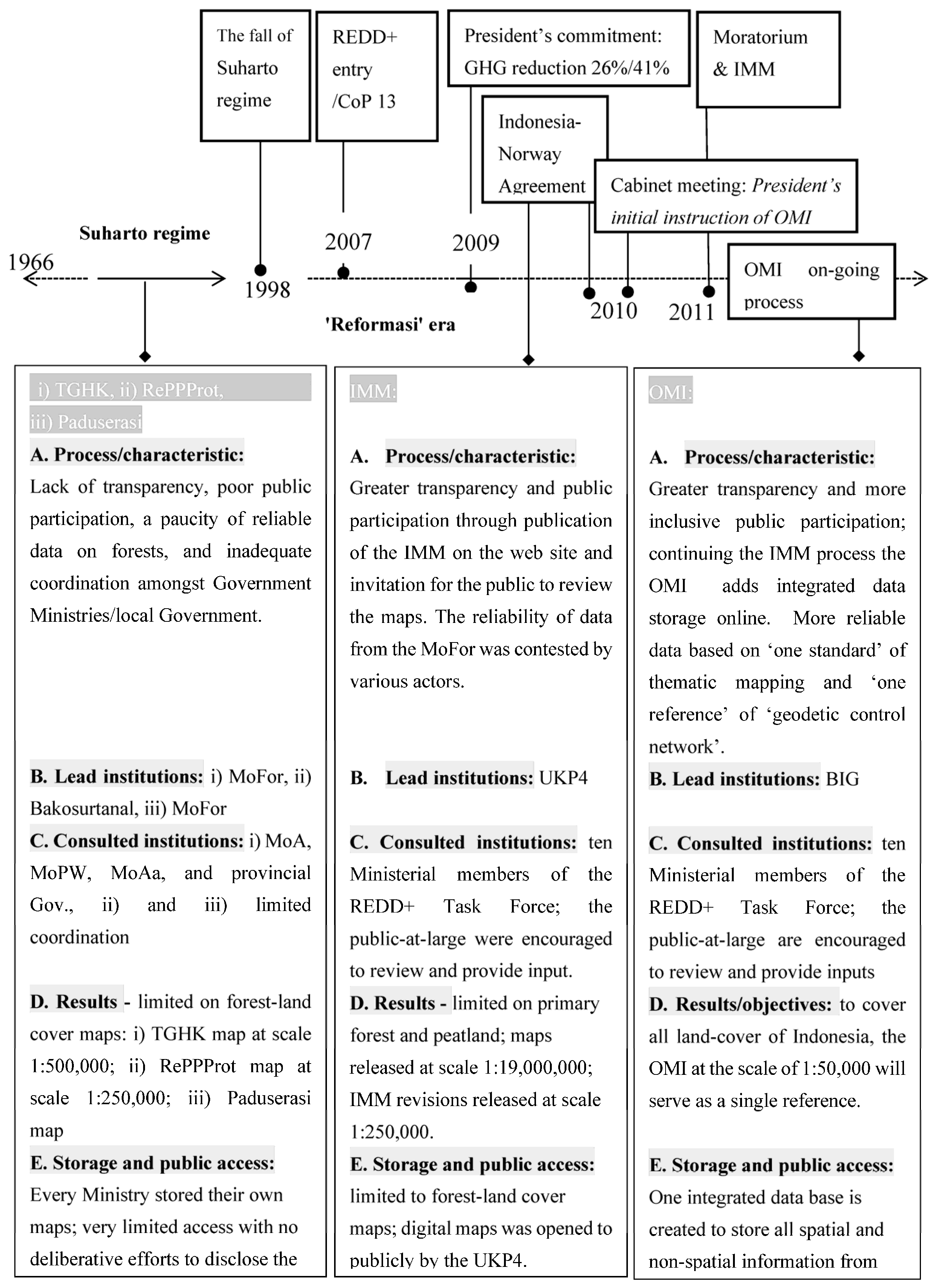
The ‘One Map Initiative’ (OMI), a national strategic policy instructed by President Yudhoyono in December 2010 [
9], is a significant development with the potential to transform Indonesian forestry institutions. This is because the policy instructs the creation of a national spatial data infrastructure and the requirement that, (i) ministries, particularly those with land-based competencies such as Forestry, Agriculture, Public Works and Housing, work together to create a single authoritative state land-cover map; (ii) the public are provided with free access to digital land-cover maps and the opportunity to evaluate them; and (iii) indigenous customary lands are integrated into the state map [
9]. This has the potential to address the problem of different land-cover maps being used by different ministries and at different levels of government, thereby addressing issues of overlapping concession areas, corruption, land-related conflicts, and social unrest [
9,
10].
The OMI was developed in the context of REDD+, a major international policy initiative that emerged from the United Nations Framework Convention on Climate Change (UNFCCC). However, this is not to suggest that the OMI is an inherent element of REDD+ institutions. Instead, as argued within this article, during its interplay with Indonesia’s forest institutions the REDD+ initiative has prompted the development of the OMI. REDD+ is intended to provide developing countries with financial incentives to produce measurable reductions in carbon emissions beyond what would have occurred without it [
11,
12]. The REDD+ mechanism includes several activities that reduce emissions from forest deforestation and degradation, conserve and enhance forest carbon stocks, and manage forests sustainably [
12].
Of particular importance in relation to the OMI is the performance-based approach within the REDD+ mechanism, whereby reductions in forest carbon emissions must be demonstrated before payments can be made [
13]. This requires a transparent and accountable system for (a) measuring carbon stocks; and (b) monitoring, reporting, and verifying (MRV) reductions in carbon emissions [
12,
14]. This entails a significant investment in the development of accurate forest datasets and mapping across multiple spatial scales in REDD+ host countries [
10,
15]. In Indonesia, REDD+ has generated an ‘interplay’ between internationally-established REDD+ institutions that require the development of certain policies within national-level forest-related institutions.
Indonesia’s forest governance institutions are complex [
16], characterised by the uncertainty and ambiguity of the legal systems surrounding forest access and land ownership [
17,
18] and a rent-seeking environment that maintains deeply-embedded clientelist practices across government and society [
3,
19,
20]. This paper examines the origin of the OMI and its implications for future forest governance and REDD+ implementation in Indonesia. It asks whether the One Map Initiative might signify a move to a new path of map-making that foregrounds transparency, coordinated cross-sectoral, and wider public participation, or whether it is just another innovation within Indonesia’s existing forestry institutions. We employ the concept of ‘path dependency’ within ‘historical institutionalism’ and examine whether REDD+ has been instrumental in creating a ‘critical juncture’ in the form of momentum for Indonesian resource and land governance institutions to move to a new path.
By positioning REDD+ in this broader context of institutional interplay and political economy, this paper complements and extends literature on REDD+ governance that analyses (i) the challenges and opportunities for the REDD+ initiative to effect forest governance reform [
21,
22,
23,
24,
25,
26,
27,
28,
29,
30] and (ii) the potential social and economic impacts of REDD+ policies on local people and communities’ participation on project implementations [
31,
32,
33,
34,
35,
36]. Moreover, concepts from political economy have been deployed to explore the challenge of REDD+ in creating incentives for forest conservation that are able to ‘out-compete’ other interests, such as timber, mining, and agricultural economics [
10,
37,
38,
39]. This paper addresses the need for more empirical evidence on the role of REDD+ in creating new institutional path-ways and the extent to which the REDD+ policy process is able to transform forest sector and cross sector regulations in host countries.
Indonesia is a key target country for REDD+ implementation for four important reasons: (a) it supports the third largest area of tropical rainforest with the fourth-largest forest carbon stock [
40,
41]; (b) an estimated 80% of the nation’s carbon emissions result from forest clearance and degradation [
42]; (c) it has an annual deforestation rate of around 1 million ha [
42]; and (d) its forest governance has historically been regarded as weak [
16,
17]. The adoption of REDD+ policies in Indonesia is supported by nearly US$2 billion of donor pledges including US$1 billion from the Government of Norway [
30,
43,
44]. Nonetheless, the potential of REDD+ to initiate a break from institutional path dependence is questioned since previous international policy initiatives have achieved minimal success in effecting forest governance reform [
45,
46].
3. Results
3.1. A Brief History of Indonesia Forest Law and Mapping Institutions
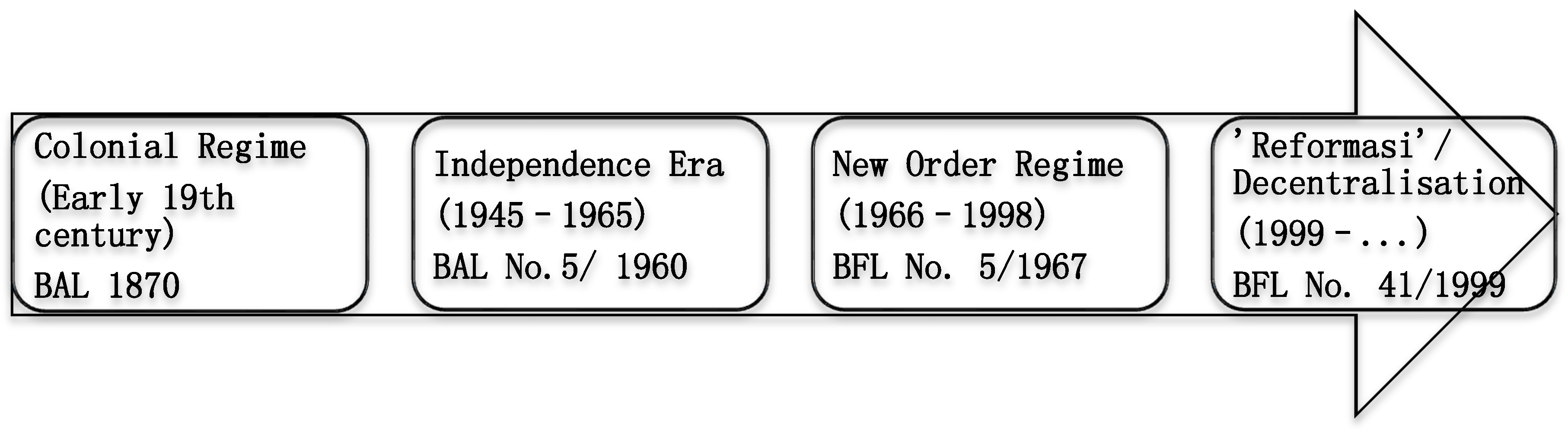
Present-day institutional pathways can be traced back to the Dutch colonial era and the 1870 Agrarian Law. This declared that all land without certified ownership was to be the domain (property) of the state [
72,
73]. This law reflected broader policies amongst colonial powers that sought to ensure the efficient exploitation of forests and in so doing framed forest resources as public goods that need to be managed in a strategic and rational manner [
74].
In the early period of Indonesian independence, the Sukarno presidency (1945–1965) replaced the 1870 Agrarian Law with the 1960 Basic Agrarian Law (BAL). Whilst this introduced measures to improve justice in land rights and recognise customary law [
73], the BAL retained the path of state sovereignty of forest resources by stating that state law is superior to customary law [
75]. Importantly, the BAL introduced the right of peasants to settle, cultivate, and claim ownership of up two hectares of forest land and designated competency for issuing land titles to district level administrations [
75,
76].
Figure 1 outlines the Basic Agrarian Law (BAL) and Basic Forestry Law (BFL) in Indonesia’s history.
This latter provision introduced a disjuncture between national level forest zoning and local forest conversion and created tension between local (district) government and higher levels of government. This was in part because the collection of rents associated with the issuance of land title permits provided local administrations with a valuable source of revenue, and, as a result, they had incentive to uphold forest zoning plans prepared by the national government [
75].
The Suharto New Order regime (1966–1998) introduced separate laws governing forest resources and agriculture. The 1967 Basic Forestry Law (BFL) reasserted state control over the majority of Indonesia’s 120–133 million ha of forest land, being 62%–69% of Indonesia’s land area [
10]. Importantly, the BFL introduced powers that enable the government to grant and manage forest concessions. This provision enabled the Suharto regime to consolidate and extend its power base through the awarding of lucrative forest concessions to supporters and led to the emergence of forestry institutions characterised by political cronyism and capital accumulation [
3,
76].
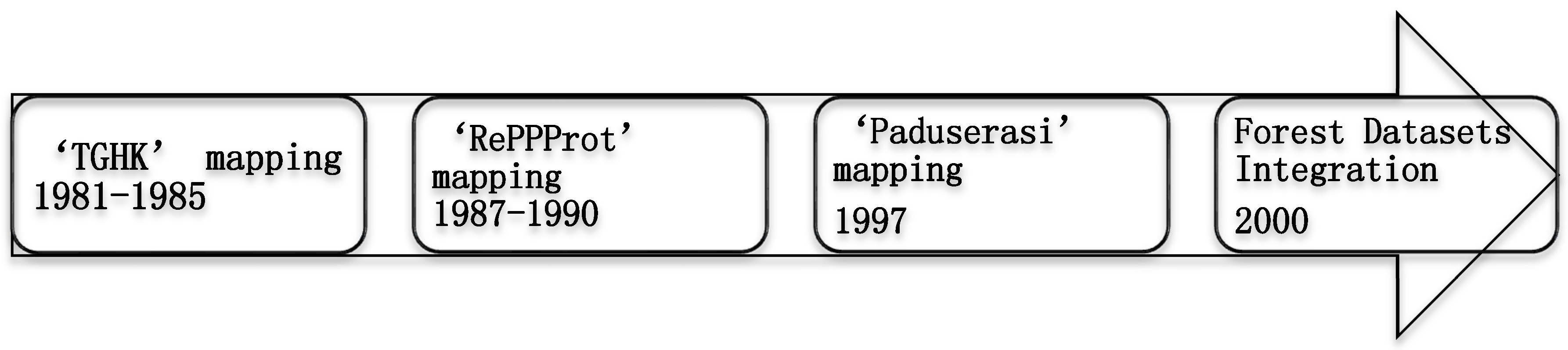
The imperative of the regime to control the allocation of lucrative forest concessions across a vast nation of 27 provinces (under the current administration of President Joko Widodo, there are now 35 provinces) and five major islands prompted three significant policies in the early 1980s: (i) elevating the department of forestry within the Ministry of Agriculture to a separate Ministry of Forestry (MoFor); (ii) establishing a state-level forest zoning and classification map known as the ‘TGHK’ (Tata Guna Hutan Kesepakatan or Forest Land Use Consensus); and (iii) establishing provincial representative offices of MoFor called Kanwil Kehutanan in 1983.
The TGHK mapping project (1981–1985) led by the MoFor further consolidated and stabilised state power over forest lands [
37]. The resulting 1:500,000 scale TGHK 1983 was published in 1983 without meaningful input from either district government, civil society, or communities, and classified State forest into six use categories, namely: protection forest, conservation forest, limited production forest, production forest, conversion forest, and unclassified lands.
An important policy impetus for the TGHK was the continuation and acceleration of the transmigration programme by the New Order regime. Originally conceived by the Dutch colonial administration in 1905, this programme involved moving people from the densely populated islands of Java, Lombok, and Madura to the larger and less populated islands, principally Sumatra, Kalimantan (Indonesian Borneo), Sulawesi, and West Papua [
77]. It was supported by a series of World Bank loans between 1976 and 1992 which received increasingly vigorous criticism from civil society groups for the lack of social and environmental safeguards. Among other things, the transmigration programme was criticised for accelerating deforestation through the issuance of concession licences, and through this, further embedded corrupt practices within the political economy of Indonesia [
78].
To address some of these criticisms the office of Regional Physical Planning Programme for Transmigration (‘RePPProt’), based within the National Coordination Agency on Survey and Mapping (‘Bakosurtanal’), led a mapping project to establish a more reliable basis for transmigration. Funded by the UK Overseas Development Administration, this map-making project applied advanced techniques (for the time) to produce maps of land systems, land use, and land status and included a revision of the TGHK at the larger scale of 1:250,000 [
9].
Notwithstanding this effort, the data on forests and land-cover maps still varied amongst ministries and was not well integrated [
9]. Moreover, complexity and uncertainty in the governance of forest land and resources were exacerbated by government ministries and local government often using inaccurate and outdated maps, resulting in conflicting customary and statutory land tenure and overlapping forest-land concessions [
10,
30].
In 1992 the Spatial Planning Law No. 24/1992 was passed to reconcile the issue of different ministries working from different and/or their own land zoning maps. It introduced rules for spatial land use planning called ‘RTRW’ (
Rencana Tata Ruang Wilayah/Regional Spatial Land Use Planning) under the authority of the National Development Planning Agency (Bappenas) and its provincial-level offices (Bappeda) [
37]. In response, the MoFor engaged in the production of its own ‘integrated maps’ (
Peta Paduserasi) published in 1997, but these were refused by some provinces who continued to refer to the earlier ‘TGHK’ map [
37].
The above explains how institutions, via basic forestry and agrarian laws and policies related to map-making, were developed to ensure the strength of path dependency of the country’s political economy. Through laws and regulations state actors, in particular the MoFor, exercise the ‘coercive element’ of power to ensure the obedience of citizens and the efficient exploitation of forest resources by awarding forest concession permits to supporters (‘incentives’). At the same time, MoFor controlled the ‘dominant information’ on forest concession and map data by limiting public participation in the map-making process. Moreover, the above also reveals how state agencies (such as MoFor and Bappenas, amongst others) and district governments competed for the political mandate and resources to lead the map-making process.
3.2. The Fall of the Suharto Regime, ‘Reformasi’, and Forestry Institutions
The Suharto New Order regime was brought to an end in 1998 by the reform (‘reformasi’) movement, a response to the Asian financial crisis of 1997 which served as an ‘exogenous shock’ to the political system. (‘Reformasi’, a local term for ‘Reformation’, describes a public movement in Indonesia, driven by students and other intellectual actors, following the Asian financial crisis in 1997 which led to the fall of the Suharto regime in 1998. This movement demanded a governance system free of corruption, collusion, and nepotism). Viewed from a critical juncture perspective, ‘reformasi’ initiated a period of institutional fluidity including public demonstrations and media calling for an end to ‘KKN’ (Korupsi, Kolusi, Nepotisme) or corruption, collusion, and nepotism. This period was also marked by increasing civil society movements which challenged the long-standing collusion between the state and forest industrialists.
The ‘reformasi’ movement presented a major challenge to the unity of the Indonesian state and forestry institutions. In response, the Habibie government (1998–1999) acted to manage the political power of resource-rich provinces by delegating regional autonomy for resource planning, and devolving decision-making to the third (district) tier of government [
3]. This policy was effected via Law No. 22/1999 on regional autonomy and Law No. 25/1999 on fiscal redistribution between the central and regional governments.
Under a new Basic Forestry Law (No. 41/1999) the state devolved management of all forest lands (other than national parks and reserves) to regional governments according to standards set by MoFor, with control over land tenure rights remaining with the National Land Bureau (NLB). This led to an increase in the overlapping authority and an intense power struggle between different levels of government and amongst ministries, representing a chaotic implementation of the decentralisation policy [
16,
17,
46]. It also gave rise to the phenomenon of ‘wild logging’ (‘wild logging’, or
penebangan liar, describes the illegal and uncontrolled logging of Indonesia’s forests, particularly during 1999–2000; it is associated with the emergence of logging networks at the district level, creating a web of political, economic, and social exchanges amongst state and non-state actors that operate against State legal norms) involving government officials, community leaders, and ‘local entrepreneurs’ controlling logging networks [
16,
17].
In an effort to control this situation and effect forest governance reform, several new initiatives were implemented including the improvement of forest data and integrated forest-land maps (see
Figure 2), most of which were supported by international donors. For instance, building on FAO support (1986–1991), in 2002 the World Bank financed a Forest Datasets Integration project which consolidated the plethora of forest maps and data sets. The resulting report emphasised the depleted state of Indonesia’s forest resources [
79] and, together with the chaos associated with the decentralisation policy, gave MoFor the pretext to gradually reassert control over forest resources [
3,
17].
Nonetheless, during this ‘reformasi’ period several other initiatives involving international donors and NGOs gained momentum. Together with REDD+ the European Union FLEGT (Forest Law Enforcement, Governance and Trade) is the latest in a series of international policy initiatives which aim to influence Indonesia’s forest governance. In October 2013, the MoFor signed an agreement on FLEGT-VPAs (Voluntary Partnership Agreements) which aims to promote trade in legally-produced timber and has been praised for its design providing a means for stakeholder participation [
80]. Effective April 2016 the European Commission confirmed Indonesia’s status as the first country to satisfy the requirements for FLEGT licencing [
81]. Furthermore, FLEGT is expected to provide another means for the state to institutionalise governance reform, including the recognition of community land and resource rights [
81]. Prior to this, in 2009 the Indonesian government established its timber legality verification system, known as SVLK (
Sistem Verifikasi Legalitas Kayu), which involved multi-stakeholder processes, though the state continues to hold final authority [
81]. In relation to land and resource tenure the SVLK has shown limited reach [
81,
82]. The success of these two initiatives has yet to be determined, and will depend largely on the independent monitoring of activities on the ground and related anti-corruption measures [
81,
82]. These two policies were often cited by MoFor interviewees as their commitment to effect forest governance reform, given their aversion to REDD+ due to the mandate for its implementation being vested in another state agency (discussed in
Section 3.3). In short, FLEGT and SVLK hold greater appeal to MoFor as both policies reassert their authority through legality verification [
80,
81].
The above-mentioned development is significant as it illustrates that, despite a series of internationally-supported initiatives to strengthen the capacity of other state agencies (e.g., state planning ‘Bappenas’ and mapping agencies ‘Bakosurtanal’) to integrate and standardise key datasets and land classification systems, MoFor continued to exercise unilateral control over forest lands [
8]. In the case of REDD+, and as discussed in the following sections, initially there was strong resistance by Mofor (see also [
65]), particularly with regard to their willingness to share information with the public on forest data and maps.
3.3. The Policy and Political Context of the OMI: The Role of REDD+ in Producing a Critical Juncture
Interviews revealed that the ‘One Map Initiative’ (OMI) emerged from the process of establishing REDD+ policy and measures at the national level. The stated objective of the OMI is to create an integrated map that will provide a single reference map of Indonesia for any decision-making related to land-based management [
9]. The map is to be based on, (i) ‘one reference’, meaning a map-making process supported by one ‘geodetic’ control network; (ii) ‘one standard’ of thematic mapping, namely the Indonesia National Standard (SNI 7645:2000) for land-cover classification; (iii) ‘one database’, meaning one integrated database of spatial and non-spatial information compiled from across ministries and different levels of government; and (iv) ‘one geo-portal’ which stores all this information, a system intended to be fully transparent and enable public participation [
9]. Interviewees from academia and research institutions identified the emphasis on agreed standards for land-use classification and the geospatial reference system as a significant development because the lack of these had previously compromised the production of integrated thematic maps.
Of particular importance was the timing of REDD+ entry into Indonesia’s political and social arena in the wake of the ‘reformasi’ era. As mentioned earlier, ‘reformasi’ legitimised discourse on ‘KKN’ (
Korupsi,
Kolusi,
Nepotisme) which led to the establishment of the Corruption Eradication Commission (
Komisi Pemberantasan Korupsi or
KPK) in 2002. This Commission gained wide public support in the midst of political uncertainty which followed the dismantling of an authoritarian regime and the introduction of democracy [
83,
84]. From a critical juncture viewpoint, this period of structural indeterminism or institutional fluidity provided levels of political freedom for policy actors and the public-at-large that had not previously been experienced. For instance, in 1999 Suharto’s successor, President Habibie, revoked the 1963 Anti-subversion Law (a Law which can be used to criminalise people whose ideas are deemed by the government to be subversive). This meant that, and as confirmed by interviewees from NGOs and academia, reformists within the government became more open in their views and acted to form alliances with non-state actors for governance reform.
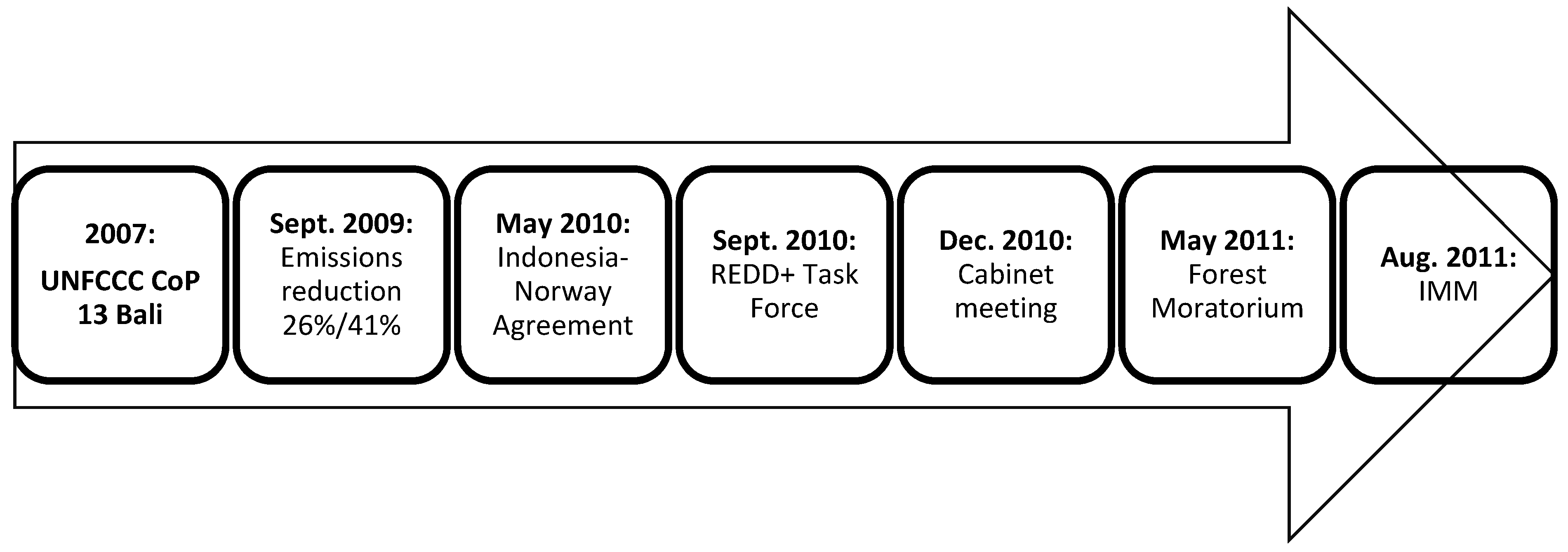
Significantly, hosting UNFCCC’s Conference of the Parties (COP) 13 in Bali in 2007 accrued political capital to senior political actors internationally and domestically. In the context of the institutional fluidity following the end of the Suharto authoritarian regime, the confluence of populist support for anti-KKN policies, and the government occupying, albeit briefly, centre stage on international climate governance, enabled and empowered influential policy actors greater freedom with which to act. Most notably, President Yudhoyono’s voluntary commitment in 2009 to reduce the country’s greenhouse gas (GHG) emissions by 26% through its own effort, or 41% with international support by 2020, was cited by interviewees as an historic landmark in Indonesia’s forest governance. This commitment led to the US$1 billion commitment from the Norway government to prepare Indonesia’s REDD+ infrastructure [
44].
Moreover, the appointment of Minister Kuntoro Mangunsubroto as the head of the REDD+ Task Force, a well-known reformist who was also the head of the Presidential Delivery Unit for Development Monitoring and Oversight (UKP4), created greater opportunity for the mobilisation of wider constituencies for reform. This demonstrated how endogenous and exogenous sources of institutional change become strongly interwoven when influential actors within government are involved.
Figure 3 highlights the historical points relating to REDD+ which marked the institutional development of map-making towards the OMI.
In accordance with the Indonesia-Norway partnership agreement in 2010, President Yudhoyono established a new institutional actor—the ‘REDD+ Task Force’—outside the MoFor. The Task Force comprised representatives of ten relevant government ministries/agencies and was mandated with preparing the national REDD+ infrastructure and coordinating all activities related to REDD+ (Presidential Decree No. 19/2010, renewed by Decree No. 25/2011). Interviews revealed mixed opinions on the merits of this decision. The majority of interviewees from existing government ministries feared that widening membership of this important policy committee would exacerbate the problem of overlapping authority inherent in Indonesia’s forest governance. On the other hand, the majority of interviewees from donor agencies, NGOs, and academia held that introducing new actors into forest policy is the only way to overcome institutional ‘stickiness’ within forest institutions and break the path-dependency of weak forest governance. One example often cited by interviewees from NGOs and civil society was that the recommendations of the 2010 Corruption Eradication Commission (KPK)’s review of the forestry sector had not been followed through by MoFor, suggesting ‘institutional stickiness’.
The KPK identified significant regulatory uncertainty and inconsistency within MoFor that had facilitated mismanagement, misuse, and corruption [
21]. Key recommendations were the review and improvement of current regulations for forest concession permits, and the establishment of a single map at 1:50,000 scale to be used as the only reference basis for issuing forest concessions [
70,
71]. Interviewees from the NGOs and academia revealed that the MoFor was reluctant to follow up these recommendations. The response of an interviewee from the private sector captures the wider view: ‘
I hold the strong belief that MoFor is more than capable of developing an accurate map with full transparency, but the question is whether they want to do it, as transparency would limit their income from rent-seeking’ (
Interviewee-41). In sum, the REDD+ initiative, as viewed by many interviewees, has provided an external push for institutional change as initiated by domestic actors such as the KPK.
The REDD+ partnership agreement between Indonesia and Norway included a clause on the suspension of licensing new concessions in the natural/primary forests and peatlands for two years, known locally as the ‘Forests Moratorium’. Through Presidential Instruction No. 10/2011 (extended for another two years via Presidential Instruction No. 6/2013 issued in May 2013) this moratorium policy included a clause on the production of an ‘Indicative Moratorium Map’ (IMM) with the MoFor assigned to lead the process. This policy, whilst receiving many criticisms for not providing adequate protection for ‘secondary’ type forests, has provided the means for efforts that improve coordination and communication, not only amongst government ministries/agencies but also between them and the indigenous people and civil society organisations (
Table 1).
The Forests Moratorium and its map (scale 1:19,000,000) was released in May 2011 [
85]. Interviews revealed that influential political actors within MoFor were initially reluctant to release the map. It was only after robust criticism from civil society and environmental groups of the map’s small scale, format (absence of ‘meta-data’—meta-data being the additional information associated with geospatial data that provides information about the data content, including for example when the image was created, who created it, and how the data was collected.), and lack of transparency on how it was generated that MoFor published the underlying land-cover data in 2009 and a series of larger scale (1:250,000) maps in June 2011. Notwithstanding these criticisms, international donor and academic interviewees held that the release of the IMM marked a significant step towards greater transparency, stressing the importance of the IMM as the embryo of the One Map Initiative. The bi-annual updating process of the IMM brings together key government ministries and agencies (see
Table 2) and involves a stakeholder feedback mechanism.
The IMM updating process involves ground verification by a monitoring team of the REDD+ Task Force and solicits input from government and private stakeholders across all levels of administration [
9]. As such, this process can be seen as evidence of the persistence of a coalition of reformist governance actors within and outside government. One REDD+ Task Force official commented that: “
This is the first time in Indonesia’s history of forest governance that various ministries joined force to update the state map which the public is able to view on-line and review” (
Interviewee-59).
Many interviewees cited President Yudhoyono’s instruction to develop the OMI, delivered during a ministerial cabinet meeting (23 December 2010), as a significant moment in Indonesia’s history of forest governance. This President’s instruction was a response to reports from Minister Kuntoro Mangunsubroto, the head of REDD+ Task Force, concerning the challenges faced in publishing the IMM due to discrepancies in land-cover maps between the Ministries of Forestry and of Environment (MoEnv). In this regard, a MoFor official indicated that the older 1990 MoFor’s map included data from a ground survey whereas the newer MoEnv’s map was produced by a consultant. The same official said: “I encouraged fellow officials at the MoFor to leave our ‘ego-sectoral’ position and support the One Map Initiative as it is good for our country” (Interviewee-5). Several interviewees revealed that though the idea for ‘one map’ and initiatives to integrate forest data have been introduced before, it had never gained such momentum until it was attached to the REDD+ initiative. One interviewee said: “The significance of REDD+ is that it emphasises public participation and transparency which are key elements of democracy. Once the people experience these elements it is very difficult to stop” (Interviewee-34).
3.4. The Significance of the OMI for Forest Governance Reform
When asked about the benefits that the OMI brings to Indonesia’s forest governance and the challenges faced with its implementation, interview responses fell into six general governance themes as stated within
Table 3.
Many interviewees cited one of the OMI’s most significant contributions as the contingency effect with respect to policy coordination amongst government ministries. The Geospatial Information Law No. 4/2011, which mandates the Geospatial Information Agency to lead the implementation of the OMI policy, including the preparation of system infrastructure and the standardisation of existing maps, was considered significant as it decouples mapping from ‘ego-sectoral’ strategies. Indeed, several interviewees expressed the hope that the OMI becomes a vehicle to improve sectoral policy integration by breaking forms of ‘ego-sectoral’ path-dependency that puts the interests of individual ministries before those of the nation. A government official stated: “The OMI movement has certainly increased communication and the sharing of information amongst ministries as never before, and as the technical working group we have promised to guard the OMI to success” (Interviewee-61). Improved data sharing and communication amongst Ministries (particularly Forestry, Agriculture, and Mining and Energy) was seen as a vehicle to improve efficiency in natural resource management. The inherently poor communication and coordination amongst them has resulted in major overlaps in resource concessions.
A REDD+ Task Force interviewee stated that the OMI is intended to promote greater transparency and provide all stakeholders with access to information about existing and new land-use licences and permits (
Interviewee-27). In the process, a ‘one geo-portal’ (
http://maps.ina-sdi.or.id) was established to provide the public with greater access to information about the state map as well as encourage them to provide input that improves it. For some this represents significant progress from previous institutional practice: in the words of a senior REDD+ Task Force official, “
The OMI is not merely a map or product, it is a movement towards greater transparency and public participation in map-making, and importantly transparency in the land-use licensing process, all of which represent a new paradigm in the governance of map-making” (
Interviewee-14). Whilst acknowledging these positives, interviewees from civil society organisations and environmental NGOs stated that it is still difficult to gain access to maps from MoFor, one of them saying: “
there is no deliberative action from MoFor to release data, and they will only do so when we ask” (
Interviewee-78). On this account, the ‘one geo-portal’ facility being established under the OMI policy represents a significant change from the old form of limited transparency towards a ‘deliberative’ form of transparency.
Interviewees from academia and donor agencies highlighted possible cost-savings resulting from the OMI, noting that this is the first time in Indonesia’s history of map-making that the costly process of acquiring and curating satellite data images is coordinated and provided by one government agency. The National Institute of Aeronautics and Space (LAPAN) received a Presidential Instruction No. 6/2012 to act as the sole authority to acquire, process, and maintain satellite data on land-cover and land-use for distribution to other government ministries/agencies. The cost efficiency is estimated to be one fourth when compared with the previous prevailing method by which each ministry/agency bought satellite imaging data individually [
9]. To this end, interviews revealed that the REDD+ Task Force has procured the technology and licences that enable direct reception of satellite data at LAPAN’s earth station. This ‘one point system’ for acquiring and processing satellite data images is widely believed by interviewees to be much less expensive than has been practiced to date. Moreover, several interviewees again suggested that reformists within the REDD+ Task Force played a significant role in making this policy materialise.
Interviewees from organisations representing indigenous and forest-dependent communities view OMI as an important opportunity for indigenous people’s land to be formally integrated into the State map. One said: “The OMI has provided important momentum for us as our work focuses on community participatory mapping. We want to ensure that ‘community-made maps’ are used not only when there is land conflict, but for any decision-making process related to communities’ development programmes” (Interviewee-76). On 14 November 2012, the National Alliance for Indigenous People (AMAN) together with Participatory Mapping Network (JKPP) officially handed to the REDD+ Task Force 265 maps covering 2.4 million ha of indigenous peoples’ land (Interviewee-75), an important event in the long running efforts within Indonesia’s system of resource governance.
In summary,
Figure 4 illustrates the historical points of institutional development that led to the OMI. As stated in the text accompanying the figure, it is evident that in the development process the OMI, as a policy initiative for map-making, has already shown significant signs of its potential to strengthen forest governance via the promotion of greater transparency and more inclusive stakeholder participation.
4. Discussion
This study asked whether the One Map Initiative might be considered a critical juncture that signifies a switch to a new pathway of map-making practice, or whether it is yet one more innovation within the existing path dependence of forestry institutions. The brief history of Indonesian forest governance presented in
Section 3.1 and
Section 3.2 is consistent with themes in historical institutionalism that suggest strong path-dependency and state institutions that further strengthen the power of already powerful groups.
For instance, the successive revisions of agrarian and forest law and developments in forest resource mapping strengthened centralised state control of forest lands, and provided a means to develop and maintain the political capital vested in forest lands. The refusal of provinces to accept the 1997 ‘Peta Paduserasi’ situation is consistent with the phenomenon termed ‘institutional stickiness’ [
58] whereby policy actors prefer the status quo, even when new institutions may offer a better outcome; their behaviours have been shaped by the long-standing institutions they live within. With regard to the development and operation of institutions, this event also explained how state agencies competed to gain the source of power such as mandates and political responsibility [
30,
52,
53,
54]. In this regard, our account suggests that ‘ego-sectoral’ attitudes, where policy actors put the interest of their ministries first [
45], both characterised and produced path dependency in Indonesia forestry institutions. A key driver of such attitudes is the fear that policy coordination amongst ministries, and across levels of government, will risk undermining the established rent-seeking practices used to finance departmental budget shortfalls [
65].
Within the historical institutionalism literature it is recognised that, even when path dependence appears broken, re-equilibrium to the old institutions practices can occur. The institutional fluidity created by the 1998 ‘reformasi’ movement, that created a political imperative to decentralise key competencies in forest governance from the state to the district level, appears to constitute a critical juncture. However, the ‘Peta Paduserasi’ process, a compilation of authoritative datasets and associated efforts on the part of MoFor to restore control over forest resources, confirms the findings of Gellert [
46] and Nomura [
86] that this act was insufficient to challenge the powerful domestic industrialist timber networks involving MoFor, and that until 2008 or even later the prevailing equilibrium within Indonesian forestry governance institutions remained. Moreover, several policy initiatives promoted by NGOs and foreign donors, that sought to influence forest governance reform, achieved limited success including the FLEGT-VPA (signed in 2013) whose success remains to be seen [
82].
The forest moratorium suggests evidence of vertical institutional interplay whereby REDD+ (i.e., source institutions) prompted the development of new institutions within existing forest governance at the national level (i.e., target institutions). In this context, our interviews suggested that the OMI is a significant development within Indonesia’s map-making due to its focus on more open and transparent access to spatial data. This exercise directly challenges the clientelist and rent-seeking practices built around MoFor’s (or other departments) producing and curating practices, controlling access to spatial data (i.e., ‘dominant information’ [
30,
52]), and decision-making concerning territory and resources (i.e., ‘(dis)incentives’ [
52]).
The OMI signifies an intent to move towards a new path of map-making, one that embodies principles of open democracy relating to greater transparency and public participation. The commitment of the government to store, curate, and integrate all spatial and non-spatial information from across ministries and levels of government in one place, and to provide the public with free access to state maps and spatial meta-data via ‘one geo-portal’ named ‘Geospasial untuk Negeri’ or ‘Indonesian Geospatial Portal’ (although, nonetheless, the data provided may not be legible to all peoples including the indigenous communities—not only may they not have easy access to the internet, they may also lack the language fluency and ability to interpret and apply the data.) represents a major shift in established institutional practice. Previously, information could only be obtained by making an official request to the relevant ministry which took considerable time and often money. The adoption of transparency principles is particularly important because once the decision was taken to scale-up transparency and public participation, for example, the involvement of the public to review and improve the map, it became progressively more difficult to return to the initial point of path dependence. In this light, the OMI signifies a switch to a new pathway of map-making practice in Indonesia.
The president’s decision to take the ‘OMI path’ and choose a new actor (BIG:
Badan Informasi Geospasial—Geospatial Information Agency), which is now under the coordination of Bappenas (State Ministry for Development Planning/National Development Planning Agency) based on the latest Presidential Regulation No. 127/2015)) to lead its development, as opposed to continuing to use the MoFor (under the current administration of President Joko Widodo, ‘MoFor’—the Ministry of Forestry is now the ‘Ministry of Environment and Forestry’)’s land-cover map, was critical in setting the development of map-making on a new path. A different decision could have plausibly led to a strengthening of the ‘status quo’ where would MoFor lead forest land-cover map-making. This finding resonates with that of earlier literature [
30] which shows a clear decline in the relative power of the MoFor during the development process of the OMI, mainly because the policy task was given to other state agencies. Nonetheless, with regard to data on forests (e.g., concession permits, thematic maps) used for the OMI mapping exercise, MoFor remains the source of ‘dominant information’ [
30]—a finding also revealed by our interviewees.
From the ‘critical juncture’ lens, the significance of this policy is also the contingency and downstream effects which appear to be unstoppable, such as the improvement of coordination amongst government ministries/agencies and between them and the indigenous and local communities. Whilst earlier literature [
27,
30] held a less optimistic view on the future implementation stage of ‘improved coordination’, this study maintains that the OMI has enabled significant progress when compared with the inherent coordination issues often cited within earlier literature on Indonesia’s forest governance (e.g., [
21,
37,
65,
66]). These findings lead us to believe that the OMI does indeed signify a critical juncture. Further, to qualify as a critical juncture the event(s) should be brief relative to the period of institutional path dependence. This is the case with the OMI. It originated with President Yudhoyono’s landmark 2009 commitment to reduce the country’s GHG emissions by 26%/41%, and was formalised in his 2010 instruction to develop the OMI in December 2010.
Our study also sought to ascertain the role of REDD+ relating to the OMI and the construction of this critical juncture. The rise of REDD+ as a major international policy mechanism came shortly after the ‘reformasi’ movement and therefore entered Indonesia during a period of structural fluidity. During this period the president and other influential reformists within the government held a significant degree of political freedom given the high level of political support existing within the public-at-large. REDD+ was manifested in the international pressure and support to modernise natural resource (forest carbon) mapping and accounting, and the OMI created a vehicle to do this, at the same time further widening political reform in Indonesia. As part of a broader reform agenda it was supported by a broad constituency from both the domestic and international arena, a phenomenon that would not have occurred in ‘normal times’. This study provided stronger evidence of the impact of an international policy (i.e., REDD+) on the resulting OMI, compared with earlier literature [
30] which suggested only ‘a reasonable extent’ of international influence.
If we accept that REDD+ created the impetus for a critical juncture in the spatial data (mapping) component of Indonesian institutions, then it is important to analyse why the REDD+ mechanism has generated changes at a scale that has not been achieved by previous international forest governance initiatives. In our view the initial policy to generate funding from the carbon market via a performance-based system is of particular importance. This created a requirement for those countries wishing to receive payments to establish transparent systems capable of measuring and verifying the results of REDD+ programmes [
13,
27,
87]. Key to this system is the development of accurate and consistent forest data sets and land-cover maps, but also the need to map, record, and resolve land ownership so that contractual arrangements relating to forest carbon can be upheld. This in turn requires coordination amongst ministries and across different levels of government.
REDD+ held the promise of new financial flows associated with carbon management policy, and the international donor community offered Indonesia substantial levels of ‘REDD readiness’ financial support. However, an expectation of this support was that Indonesia would introduce a moratorium on the issuance of forest concession licences. This stimulated the development and publication of the Indicative Moratorium Map (IMM) and in the process promoted transparency and public participation. The IMM then stimulated the development of the OMI. Moreover, because the REDD+ initiative embodies multiple agendas and objectives from climate change mitigation, to poverty reduction, and the protection of human rights and biodiversity, it created unparalleled levels of support from a wide range of international and domestic actors [
24,
30,
54,
88] who also lent their support to the OMI.
Whilst REDD+ policy has contributed to the development of the OMI at a critical juncture, this study finds that a range of exogenous and endogenous factors created a basis of support for REDD+ policy development in Indonesia. For instance, the 1997 Asian financial crisis served as an exogenous shock that generated the ‘reformasi’ movement which, together with an endogenous desire for change, led to the end of three decades of the Suharto regime. Given these circumstances REDD+ might be considered as a policy ‘connector’ that gave the issue of spatial data and transparency a political form and agency which manifested in the OMI (i.e., a modern spatial data infrastructure) as a tool for the reform of government institutions. The OMI was a product of the exogenous policy force of REDD+ interacting with an endogenous movement of high-ranking politicians and officials supported by domestic constituencies working for reform.
5. Conclusions
Deploying ‘path dependency’ within ‘historical institutionalism’ our study sought to determine whether the One Map Initiative signifies a switch to a new path of Indonesia’s map-making practice. Research results show positive signs that the OMI, in its current stage, has already shown its ability to change the prevailing path-dependence of map-making which was characterised by a lack of transparency, a poor level of public participation, and inadequate coordination amongst ministries. During its map-making exercise this policy promotes several good governance norms, namely better coordination amongst government ministries, greater transparency and public participation, improved cost efficiency and forest data quality, and the protection of indigenous people’s land (see
Section 3.4). Notable is the establishment of ‘one geo-portal’ (named ‘Geospasial untuk Negeri’ or ‘Indonesian Geospatial Portal’) which shows government’s commitment to provide the public with free access to state maps and spatial data, and encourage them to be involved in updating and providing input to state maps. This denotes a very significant shift in the established institutional practice of map-making.
Moreover, this article sought to determine whether REDD+ has been instrumental in creating a ‘critical juncture’ in the form of momentum for Indonesian resource and land governance institutions to adopt a new path. During the establishment process of the ‘forest moratorium’ to enable the implementation of REDD+, the embryo of the OMI (i.e., the ‘Indicative Moratorium Map’) was created (see
Section 3.3). This ‘forest moratorium’ produces evidence of institutional interplay, with REDD+ prompting the development of new institutions within the forest governance prevailing at the national level. In this regard, the REDD+ ‘performance-based system’ has required host countries to establish transparent systems for measuring and verifying the results of REDD+ programmes, which in turn required the development of accurate and consistent forest data sets and land-cover maps. To this end, the REDD+ initiative has given spatial data and transparency a political form and agency which became manifested in the OMI. Viewed via a ‘critical juncture’ lens, the implementation of transparency principles is particularly important since the decision to scale-up transparency and public participation (e.g., the involvement of the public to review and improve the map) made it progressively more difficult to return to the initial point of path dependence. In short, REDD+ has contributed to the creation of a critical juncture via momentum for forest and land governance to move to a new path through greater transparency and public participation.
This study also finds that a number of exogenous and endogenous factors enabled a basis of support for REDD+ policy development in Indonesia. This includes the large presence of constituencies for governance reform, and the ‘structural fluidity’ resulting from the ‘reformasi’ movement following the Asian financial crisis of 1997 and the fall of the Soeharto regime in 1998 (see
Section 3.2 and
Section 3.3). The time that the REDD+ initiative entered Indonesia’s political area, shortly after the ‘reformasi’ movement, was critical to its relative success in effecting governance reform. REDD+ was promoted as an international policy initiative to reform the governance of forest resources and land via advanced forest carbon mapping and accounting. A ‘critical juncture’ lens reveals that this reform agenda was supported by a broad constituency from both the domestic and international arena during ‘institutional fluidity’, greater than would have occurred in normal times.
At the initial time of writing the future of the OMI was in question. However, the latest development, including a commitment by the current President Joko Widodo to accelerate the implementation of the OMI and position this policy high on the National Development Priority (based on Presidential Regulation No. 127/2015, the National Development Planning Agency (Bappenas) is given a mandate to coordinate activities falling under the Geospatial Information Agency) suggests another positive sign that its grounded implementation is viable. The implication of the OMI for the future implementation of REDD+ is threefold. Firstly, clarity on categories of forest land use produces certainty where REDD+ can take place. Secondly, transparency on forest data, particularly on the concessions already issued, means that there is no risk of REDD+ investment being undermined by overlapping concessions. Thirdly, and importantly, for the performance-based approach, and particularly for a market-based system that requires carbon emissions reduction to be assessed, the development of accurate forest data sets and land-cover maps is critical to the efficacy of REDD+ implementation.
Further research is necessary to follow the on-the-ground implementation of the OMI to ascertain whether, in the long run, this policy initiative can serve as a means to break the path dependency of map-making institutions, or whether there are signs that a ‘re-equilibrium’ within map-making institutions will occur.


