The Concept of Landscape Structure, Forest Continuum and Connectivity as a Support in Urban Forest Management and Landscape Planning


Abstract
:1. Introduction
2. Materials and Methods
3. Results
4. Discussion
5. Conclusions
- (1)
- The preservation of urban forests with close-to-nature tree composition;
- (2)
- The preservation of older urban forests;
- (3)
- The preservation of areas with persistent forest cover;
- (4)
- The preservation of green infrastructure networks, supporting connectivity between urban forests and sub-urban green areas.
Author Contributions
Funding
Conflicts of Interest
References
- Angel, S.; Blei, A.M.; Parent, J.; Lamson-Hall, P.; Sánchez, N.G.; Civco, D.L.; Qian Lei, R.; Thom, K. Areas and Densities. In Atlas of Urban Expansion—2016 Edition; NYU Urban Expansion Program at New York University, UN-Habitat, and the Lincoln Institute of Land Policy: New York, NY, USA, 2016; Volume 1, p. 489. ISBN 978-970-9981758-0-5. [Google Scholar]
- Wang, Z. Evolving landscape-urbanization relationships in contemporary China. Landsc. Urban Plan. 2018, 171, 30–41. [Google Scholar] [CrossRef]
- Kuang, W.; Chi, W.; Lu, D.; Doue, Y. A comparative analysis of megacity expansions in China and the U.S.: Patterns, rates and driving forces. Landsc. Urban Plan. 2014, 132, 121–135. [Google Scholar] [CrossRef]
- Kabisch, N.; Haase, D. Green spaces of European cities revisited for 1990–2006. Landsc. Urban Plan. 2013, 110, 113–122. [Google Scholar] [CrossRef]
- UN Habitat. Urbanization and Development: Emerging Futures; World Cities Report; United Nations Human Settlements Programme: Nairobi, Kenya, 2016; p. 247. [Google Scholar]
- Ahern, J. Urban landscape sustainability and resilience: The promise and challenges of integrating ecology with urban planning and design. Landsc. Ecol. 2012, 28, 6. [Google Scholar] [CrossRef]
- Pascual-Hortal, L.; Saura, S. Comparison and development of new graph-based landscape connectivity indices: Towards the priorization of habitat patches and corridors for conservation. Landsc. Ecol. 2006, 21, 959–967. [Google Scholar] [CrossRef]
- Pascual-Hortal, L.; Saura, S. A new habitat availability index to integrate connectivity in landscape conservation planning: Comparison with existing indices and application to a case study. Landsc. Urban Plan. 2007, 83, 91–103. [Google Scholar] [CrossRef]
- Saura, S.; Rubio, L. A common currency for the different ways in which patches and links can contribute to habitat availability and connectivity in the landscape. Ecography 2010, 33, 523–537. [Google Scholar] [CrossRef]
- Saura, S.; Estreguil, C.; Mouton, C.; Rodriguez-Freire, M. Network analysis to assess landscape connectivity trends; Application to European Forests (1990–2000). Ecol. Indic. 2011, 11, 407–416. [Google Scholar] [CrossRef]
- Saura, S.; Vogt, P.; Velázquez, J.; Hernando, A.; Tejera, R. Key structural forest connectors can be identified by combining landscape spatial pattern network analyses. For. Ecol. Manag. 2011, 262, 150–160. [Google Scholar] [CrossRef]
- Hladnik, D.; Pirnat, J. Urban forestry—linking naturalness and amenity: The case of Ljubljana, Slovenia. Urban For. Urban Green. 2011, 10, 105–112. [Google Scholar] [CrossRef]
- Pirnat, J.; Hladnik, D. Connectivity as a tool in the prioritization and protection of sub-urban forest patches in landscape conservation planning. Landsc. Urban Plan. 2016, 153, 129–139. [Google Scholar] [CrossRef]
- Antrop, M.; van Eetvelde, V. Landscape Perspectives: The Holistic Nature of Landscape, 1st ed.; Springer: Dordrecht, The Netherlands, 2017; p. 436. ISBN 978-994-024-1181-1182. [Google Scholar]
- Naveh, Z. Interactions of landscapes and cultures. Landsc. Urban Plan. 1995, 32, 43–54. [Google Scholar] [CrossRef]
- Pinto-Correia, T.; Primdahl, J.; Pedroli, B. European Landscapes in Transition: Implication for Policy and Practice, 1st ed.; Cambridge University Press: Cambridge, UK, 2018; p. 286. ISBN 978-971-107-07069-07061. [Google Scholar]
- Verboom, J.; Wamelink, W. Spatial modeling in landscape ecology. In Issues and Perspectives in Landscape Ecology, 1st ed.; Wiens, J.A., Moss, M.R., Eds.; Cambridge Univeristy Press: Cambridge, UK, 2005; pp. 79–89. ISBN 978-970-521-53754-53751. [Google Scholar]
- Solecka, I.; Raszka, B.; Krajewski, P. Landscape analysis for sustainable land use policy: A case study in the municipality of Popielów, Poland. Land Use Policy 2018, 75, 116–126. [Google Scholar] [CrossRef]
- Hladnik, D.; Tajnikar, M. Gozdni habitatni tipi območij Natura 2000 v krajinski zgradbi Pohorja. Zbornik Gozdarstva in Lesarstva 2008, 87, 15–32. [Google Scholar]
- Pirnat, J.; Kobler, A. Landscape changes in the Pivka area, Slovenia. Zbornik Gozdarstva in Lesarstva 2012, 98, 39–49. [Google Scholar]
- Pirnat, J.; Kobler, A. Stabilnost gozdnih površin v Sloveniji kot kriterij krajinske pestrosti in obstojnosti. Acta Silvae et Ligni 2014, 104, 35–42. [Google Scholar] [CrossRef]
- Hladnik, D. Presoja prostorskega stratificiranja za vzorčno ocenjevanje gozdnih zemljišč. Acta Silvae et Ligni 2015, 108, 19–28. [Google Scholar]
- McGarigal, K. Landscape Metrics for Categorical Map Patterns. Lecture Notes. Available online: http://www.umass.edu/landeco/teaching/landscape_ecology/schedule/chapter9_metrics.pdf (accessed on 3 July 2018).
- EEA (European Environment Agency). Landscape Fragmentation in Europe; European Environment Agency; Technical Report; EEA (European Environment Agency): Copenhagen, Danmark, 2011; p. 87. ISSN 1725-9177. [Google Scholar]
- Girvetz, E.H.; Thorne, J.H.; Berry, A.M.; Jaeger, J.A.G. Integration of landscape fragmentation analysis into regional planning: A statewide multiscale case study from California, USA. Landsc. Urban Plan. 2008, 86, 205–218. [Google Scholar] [CrossRef]
- Jongman, R.H.G. Homogenisation and fragmentation of the European landscape: Ecological consequences and solutions. Landsc. Urban Plan. 2001, 58, 211–221. [Google Scholar] [CrossRef]
- Statistical Office of the Republic of Slovenia. Data by Statistical Regions. Available online: http://pxweb.stat.si/pxweb/Database/Regions/Regions.asp (accessed on 26 August 2018).
- National Report on Urban Developmentm—HABITAT III. Ministry of the Environment and Spatial Planning of the Republic of Slovenia. Spatial Planning, Construction and Housing Directorate. Available online: http://www.mop.gov.si/fileadmin/mop.gov.si/pageuploads/publikacije/en/porocilo_urbani_razvoj_HabitatIII.pdf (accessed on 26 August 2018).
- Alvey, A.A. Promoting and preserving biodiversity in the urban forest. Urban For. Urban Green. 2006, 5, 195–201. [Google Scholar] [CrossRef]
- Environment Canada. How Much Habitat is Enough? 3rd ed.; Environment Canada: Toronto, ON, Canada, 2013; p. 130. ISBN 978-1-100-21921-9.
- Pauleit, S.; Jones, N.; Nyhuus, S.; Pirnat, J.; Salbitano, F. Urban forest resources in European cities. In Urban Forests and Trees, 1st ed.; Konijnendijk, C.C., Nilsson, K., TRandrup, T.B., Schipperijn, J., Eds.; Springer: Berlin, Germany, 2005; pp. 49–80. ISBN 978-3-540-25126-2. [Google Scholar]
- Peterken, G.F. Natural Woodland: Ecology and Conservation in Northern Temperate Regions., 1st ed.; Cambridge University Press: Cambridge, UK, 1996; p. 522. ISBN 521-36613-5. [Google Scholar]
- Remmert, H. Ökologie: Ein Lehrbuch, 1st ed.; Springer: Berlin/Heidelberg, Germany, 2013; p. 351. ISBN 978-3-540-54732-7. [Google Scholar]
- Winter, S.; Fischer, H.S.; Fischer, A. Relative quantitative reference approach for naturalness assessments of forests. For. Ecol. Manag. 2010, 259, 1624–1632. [Google Scholar] [CrossRef]
- Kovač, M.; Hladnik, D.; Kutnar, L. Biodiversity in (the Natura 2000) forest habitats is not static: Its conservation calls for an active management approach. J. Nat. Conserv. 2018, 43, 250–260. [Google Scholar] [CrossRef]
- Pirnat, J.; Hladnik, D. Artificial energy inputs into spruce lowland forests in suburban landscapes in Slovenia. Zbornik Gozdarstva in Lesarstva 2009, 89, 67–77. [Google Scholar]
- Firm, D.; Pirnat, J. Predlog metodologije za razmejevanje kmetijskih in primestnih krajin v Sloveniji ter prostorska določila za določanje gozdov s poudarjeno funkcijo ohranjanja biotske raznovrstnosti. Gozdarski Vestn. 2017, 5, 246–263. [Google Scholar]
- Verlič, A.; Arnberger, A.; Japelj, A.; Simončič, P.; Pirnat, J. Perceptions of recreational trail impacts on an urban forest walk: A controlled field experiment. Urban For. Urban Green. 2015, 14, 89–98. [Google Scholar] [CrossRef]
- Coulson, R.N.; Tchakerian, M.D. Basic Landscape Ecology; Knowledge Engineering Laboratory Partners, Inc.: College Station, TX, USA, 2010; p. 300. ISBN 978-970-9831617-0-7. [Google Scholar]
- Gurevitch, J.; Scheiner, S.M.; Fox, G.A. The Ecology of Plants; Sinauer Associates, Inc., Publishers: Sunderland, MA, USA, 2002; p. 523. ISBN 0-87893-291-7. [Google Scholar]
- Regulation (EC) No 1059/2003 of the European Parliament and of the Council on the Establishment of a Common Classification of Territorial Units for Statistics (NUTS). Official Journal of the European Union L 154/1. Available online: http://data.europa.eu/eli/reg/2003/1059/oj (accessed on 13 June 2018).
- Statistical Office of the Republic of Slovenia. Data on Population of Slovenia by Settlements. Available online: http://www.stat.si/StatWeb/en/Field/Index/20/65 (accessed on 26 August 2018).
- Copernicus. Copernicus Land Service—Pan-European Component: CORINE Land Cover. Available online: http://land.copernicus.eu/pan-european/corine-land-cover (accessed on 11 July 2018).
- Hornsten, L.; Fredman, P. On the distance to recreational forests in Sweden. Landsc. Urban Plan. 2000, 51, 1–10. [Google Scholar] [CrossRef]
- Arnberger, A. Recreation use of urban forests: An inter-area comparison. Urban For. Urban Green. 2006, 5, 135–144. [Google Scholar] [CrossRef]
- Hladnik, D. Spatial structure of disturbed landscapes in Slovenia. Ecol. Eng. 2005, 24, 17–27. [Google Scholar] [CrossRef]
- Slovenian Ministry of Agriculture, Forestry and Food. Grafični podatki RABA za celo Slovenijo. Available online: http://rkg.gov.si/GERK/ (accessed on 30 April 2015).
- Slovenia Forest Service. Forest Stand Map. Available online: http://prostor.zgs.gov.si/pregledovalnik/ (accessed on 26 August 2018).
- Schuetz, J.-P.; Saniga, M.; Diaci, J.; Vrška, T. Comparing close-to-nature silviculture with processes in pristine forests: Lessons from Central Europe. Ann. For. Sci. 2016, 73, 911–921. [Google Scholar] [CrossRef]
- Rules on the Records of Actual Arable Land Use; No 122/80; Official Gazette of the Republic of Slovenia: Ljubljana, Slovenia, 2008. Available online: http://www.pisrs.si/Pis.web/pregledPredpisa?id=PRAV9267 (accessed on 26 August 2018).
- Slovenian Infrastructure Agency. Road and Railway Infrastructure. Available online: http://www.mzi.gov.si/si/delovna_podrocja/ceste/drzavne_ceste/#c10917/zeleznice_in_zicnice/javna_zelezniska_infrastruktura (accessed on 15 October 2015).
- The Surveying and Mapping Authority of the Republic of Slovenia. Cadastre of Public Infrastructure—Transport Infrastructure. Available online: http://www.e-prostor.gov.si/zbirke-prostorskih-podatkov/zbirni-kataster-gospodarske-javne-infrastrukture/ (accessed on 26 August 2018).
- Kutnar, L.; Veselič, Ž.; Dakskobler, I.; Robič, D. Tipologija gozdnih rastišč Slovenije na podlagi ekoloških in vegetacijskih razmer za potrebe usmerjanja razvoja gozdov. Gozdarski Vestn. 2012, 70, 195–214. [Google Scholar]
- Barbati, A.; Corona, P.; Marchetti, M. A forest typology for monitoring sustainable forest management: The case of European forest types. Plant Biosyst. 2007, 141, 93–103. [Google Scholar] [CrossRef] [Green Version]
- Forest Europe. Improved Pan-European Indicators for Sustainable Forest Management. Ministerial Conference on the Protection of Forests in Europe, Liaison Unit Vienna. Available online: https://www.foresteurope.org/documentos/improved_indicators.pdf (accessed on 17 July 2018).
- Barbati, A.; Marchetti, M.; Chirici, G.; Corona, P. European Forest Types and Forest Europe SFM indicators: Tools for monitoring progress on forest biodiversity conservation. For. Ecol. Manag. 2014, 321, 145–157. [Google Scholar] [CrossRef] [Green Version]
- Golob, A. Izhodišča za monitoring ohranjenosti gozdnih habitatnih tipov in habitatov vrst na območjih Natura 2000 v Sloveiji. Studia For. Slov. 2006, 127, 223–246. [Google Scholar]
- Slovenia Forest Service. Forest Compartment Database. Available online: http://prostor.zgs.gov.si/pregledovalnik/ (accessed on 17 July 2018).
- Mapire. The Historical Map Portal. Available online: http://mapire.eu/en/ (accessed on 06 June 2018).
- ESRI. ArcGIS Desktop Release 10.4; Environmental Systems Research Institute: Redlands, CA, USA, 2016. [Google Scholar]
- Kasanko, M.; Barredo, J.I.; Lavalle, C.; McCormic, N.; Demicheli, L.; Sagris, V.; Brezger, A. Are European cities becoming dispersed? A comparative analysis of 15 European urban areas. Landsc. Urban Plan. 2006, 77, 111–130. [Google Scholar] [CrossRef]
- Krajewski, P. Assessing change in a high-value landscape: Case study of the municipality of Sobotka, Poland. Pol. J. Environ. Stud. 2017, 26, 2603–2610. [Google Scholar] [CrossRef]
- Vrščaj, B. Sprememba rabe zemljišč in kmetijstvo. Kazalci okolja v Sloveniji. Kmetijstvo. Ministry of the Environment and Spatial Planning of the Republic of Slovenia. Available online: http:// kazalci.arso.gov.si/?data=indicator&ind_id=460 (accessed on 26 August 2018).
- Ambrose-Oji, B.; Buijs, A.; Gerőházi, E.; Mattijssen, T.; Száraz, L.; Van der Jagt, A.; Hansen, R.; Rall, E.; Andersson, E.; Kronenberg, J.; Rolf, W. Innovative Governance for Urban Green Infrastructure: A Guide for Practitioners, GREEN SURGE project Deliverable 6.3; University of Copenhagen: Copenhagen, Denmark, 2017; Available online: https://greensurge.eu/products/ (accessed on 27 August 2018).
- McRoberts, R.E.; Chirici, G.; Winter, S.; Barbati, A.; Corona, P.; Marchetti, M.; Hauk, E.; Brändli, U.-B.; Beranova, J.; Rondeaux, J.; et al. Prospects for harmonized biodiversity assessments using national forest inventory data. In National Forest Inventories: Contributions to Forest Biodiversity Assessments, 1st ed.; Chirici, G., Winter, S., McRoberts, R.E., Eds.; Springer: Heidelberg, Germany, 2011; pp. 41–97. ISBN 978-94-007-0481-7. [Google Scholar]
- Ritters, K.H.; Wickham, J.D.; Wade, T.G. Evaluating ecoregions for sampling and mapping land-cover patterns. Photogramm. Eng. Remote Sens. 2006, 72, 781–788. [Google Scholar] [CrossRef]
- Dramstad, W.E.; Fjellstad, W.J.; Strand, G.H.; Mathiesen, H.F.; Engan, G.; Stokland, J.N. Development and implementation of the Norwegian monitoring programme for agricultural landscapes. J. Environ. Manag. 2002, 64, 49–63. [Google Scholar] [CrossRef]
- Peterseil, J.; Wrbka, T.; Plutzar, C.; Schmitzberger, I.; Kiss, A.; Szerencsits, E.; Reiter, K.; Schneider, W.; Suppan, F.; Beissmann, H. Evaluating the ecological sustainability of Austrian agricultural landscapes—The SINUS approach. Land Use Policy 2004, 21, 307–320. [Google Scholar] [CrossRef]
- Ståhl, G.; Allard, A.; Esseen, P.-A.; Glimskär, A.; Ringvall, A.; Svensson, J.; Sundquist, S.; Christensen, P.; Torell, Å.; Högström, M.; et al. National inventory of landscapes in Sweden (NILS)—Scope, design, and experiences from establishing a multiscale biodiversity monitoring system. Environ. Monit. Assess. 2011, 173, 579–595. [Google Scholar] [CrossRef] [PubMed]
- Aune-Lundberg, L.; Strand, G.H. Comparison of variance estimation methods for use with two-dimensional systematic sampling of land use/land cover data. Environ. Model. Softw. 2014, 61, 87–97. [Google Scholar] [CrossRef]
- Stehman, S.V.; Sohl, T.L.; Loveland, T.R. Statistical sampling to characterize recent United States land-cover change. Remote Sens. Environ. 2003, 86, 517–529. [Google Scholar] [CrossRef]
- Miličić, V.; Udovč, A. Uporabnost prostorskih podatkov kmetijskega sektorja za analize sprememb rabe kmetijskih zemljišč na primeru izbranega območja varovanja narave v Sloveniji. Geodetski Vestn. 2012, 56, 83–104. [Google Scholar] [CrossRef]


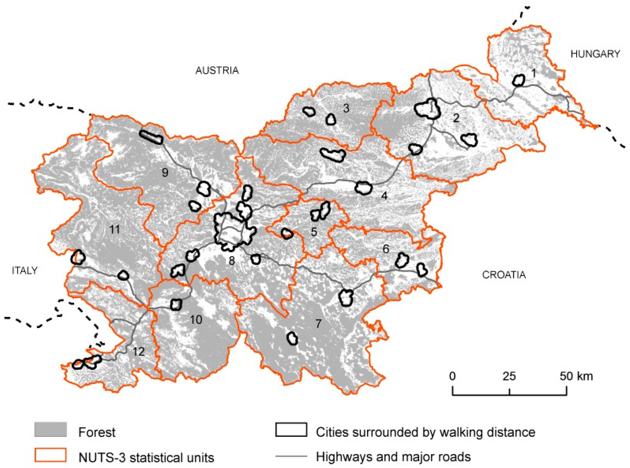
| Name of Region | Area | Landscape | Share 2 | And Number of Agricultural LT | ||
|---|---|---|---|---|---|---|
| in Slovene | (km2) | Type (LT) 1 | (%) | Large 3 | Medium 4 | Small 5 |
| 1. Pomurska | 1337.05 | Agricultural (Agr) | 99.3 | 6 | 1 | 2 |
| 2. Podravska | 217.16 | Agricultural | 72.2 | 7 | 3 | 3 |
| 3. Koroška | 1040.80 | Forested (For) | 8.3 | 0 | 1 | 2 |
| 4. Savinjska | 2299.74 | For/Agr | 36.2 | 5 | 4 | 7 |
| 5. Zasavska | 490.01 | Forested | 4.7 | 1 | 0 | 3 |
| 6. Posavska | 967.60 | For/Agr | 46.2 | 4 | 1 | 4 |
| 7. JV Slovenija | 2670.19 | For/Agr | 22.4 | 1 | 8 | 4 |
| 8. Osrednjeslovenska | 2333.89 | For/Agr | 30.8 | 3 | 5 | 15 |
| 9. Gorenjska | 2136.60 | Forested | 14.4 | 1 | 2 | 6 |
| 10. Primorsko-notranjska | 1456.34 | For/Agr | 20.8 | 1 | 3 | 5 |
| 11. Goriška | 2324.71 | For/Agr | 10.4 | 0 | 5 | 4 |
| 12. Obalno kraška | 1044.36 | For/Agr | 31.5 | 1 | 1 | 8 |
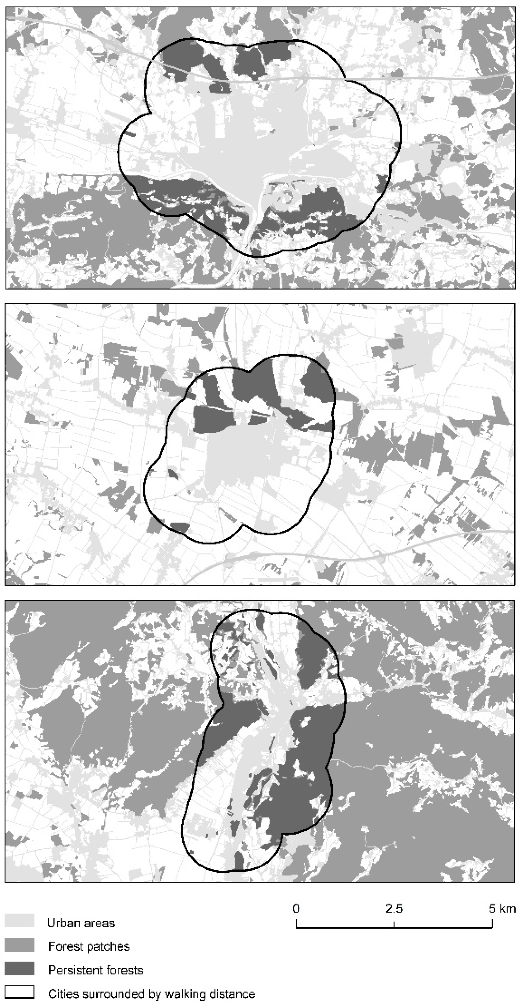
| Code | City | Area (km2) | Inh 1 (1000) | Landscape Type 2 | FC 3 (%) | FA 4 (km2) | LM 5 (%) | LP 6 (%) | FST 7 | CT 8 (%) | CH 9 (%) | SC 10 (%) |
|---|---|---|---|---|---|---|---|---|---|---|---|---|
| 1 | Murska Sobota | 4.00 | 11.6 | L Agr | 15 | 1.14 | 0 | 100 | 53 | 88 | −12 | 57 |
| 2.1 | Maribor | 24.81 | 95.2 | M Agr/Urb | 10 | 12.65 | 30 | 70 | 71/78 | 83 | −8 | 35 |
| 2.2 | Ptuj | 5.43 | 18.2 | L Agr | 9–34 | 3.16 | 0 | 100 | 54/73 | 67 | −2 | 17 |
| 2.3 | Slov. Bistrica | 3.47 | 7.4 | L Agr | 29 | 3.95 | 61 | 39 | 54 | 89 | −9 | 30 |
| 3.1 | Ravne | 2.08 | 7.0 | S Agr | 22 | 6.56 | 96 | 4 | 77/75 | 78 | +6 | 0 |
| 3.2 | Slov. Gradec | 2.26 | 7.5 | M Agr | 20 | 3.82 | 76 | 24 | 77/75 | 85 | −1 | 39 |
| 4.1 | Celje | 9.76 | 37.5 | S Agr/Urb | 2 | 5.50 | 79 | 21 | 74/73 | 84 | −1 | 86 |
| 4.2 | Velenje | 7.40 | 25.5 | M Agr | 26 | 14.19 | 36 | 64 | 73 | 92 | −5 | 49 |
| 5.1 | Zagorje | 1.48 | 6.4 | Forested | 24 | 8.00 | 91 | 9 | 58/59 | 73 | +9 | 88 |
| 5.2 | Trbovlje | 3.39 | 15.2 | S Agr | 24 | 11.55 | 91 | 9 | 75/59 | 69 | +5 | 86 |
| 5.3 | Litija | 1.63 | 6.5 | S Agr | 5 | 6.32 | 99 | 1 | 75 | 84 | +4 | 9 |
| 6.1 | Krško | 4.24 | 7.1 | L Agr | 21 | 7.15 | 81 | 19 | 73/55 | 79 | +1 | 56 |
| 6.2 | Brežice | 2.20 | 6.6 | L Agr | 21 | 1.03 | 28 | 72 | 53/55 | 34 | +3 | 82 |
| 7.1 | Kočevje | 2.58 | 8.7 | L Agr | 4 | 4.00 | 87 | 13 | 64 | 33 | +17 | 41 |
| 7.2 | Novo mesto | 6.51 | 23.3 | L Agr | 29 | 10.65 | 47 | 53 | 55/54 | 77 | +3 | 46 |
| 8.1 | Kamnik | 3.67 | 13.6 | L Agr | 33 | 7.24 | 86 | 14 | 75/74 | 84 | 0 | 16 |
| 8.2 | Mengeš | 1.61 | 6.1 | L Agr | 33 | 1.57 | 98 | 2 | 74 | 80 | +3 | 99 |
| 8.3 | Domžale | 5.09 | 12.4 | L Agr | 33 | 2.33 | 45 | 55 | 74 | 71 | +1 | 16 |
| 8.4 | Ljubljana | 59.76 | 272.2 | L Agr/Urb | 13 | 49.96 | 71 | 29 | 75/74 | 80 | +1 | 66 |
| 8.5 | Grosuplje | 1.68 | 7.1 | M Agr | 9 | 1.98 | 55 | 45 | 55 | 84 | −3 | 12 |
| 8.6 | Vrhnika | 3.14 | 8.4 | S Agr | 8 | 4.15 | 82 | 18 | 55 | 35 | +13 | 49 |
| 8.7 | Logatec | 2.89 | 8.9 | S Agr | 12 | 11.44 | 97 | 3 | 64 | 31 | +35 | 32 |
| 9.1 | Jesenice | 4.83 | 13.4 | S Agr | 10 | 17.57 | 98 | 2 | 63/59 | 71 | +14 | 33 |
| 9.2 | Kranj | 7.55 | 36.9 | M Agr | 43 | 4.92 | 44 | 56 | 71/54 | 47 | +5 | 45 |
| 9.3 | Škofja Loka | 2.17 | 12.0 | M Agr | 20 | 5.61 | 95 | 5 | 55/75 | 92 | −5 | 37 |
| 10 | Postojna | 2.68 | 9.2 | M Agr | 16 | 7.44 | 86 | 14 | 56/64 | 14 | +36 | 32 |
| 11.1 | Ajdovščina | 2.07 | 6.6 | S Agr | 11 | 3.48 | 98 | 2 | 56 | 3 | +28 | 48 |
| 11.2 | Nova Gorica | 5.19 | 13.2 | M Agr | 34 | 7.79 | 95 | 5 | 54/56 | 59 | +10 | 47 |
| 12.1 | Izola | 2.12 | 11.2 | L Agr | 25 | 0.84 | 0 | 100 | 56 | 15 | +5 | 55 |
| 12.2 | Koper | 5.67 | 25.0 | L Agr | 25 | 0.80 | 0 | 100 | 56 | 7 | +2 | 45 |
© 2018 by the authors. Licensee MDPI, Basel, Switzerland. This article is an open access article distributed under the terms and conditions of the Creative Commons Attribution (CC BY) license (http://creativecommons.org/licenses/by/4.0/).
Share and Cite
Pirnat, J.; Hladnik, D. The Concept of Landscape Structure, Forest Continuum and Connectivity as a Support in Urban Forest Management and Landscape Planning. Forests 2018, 9, 584. https://doi.org/10.3390/f9100584
Pirnat J, Hladnik D. The Concept of Landscape Structure, Forest Continuum and Connectivity as a Support in Urban Forest Management and Landscape Planning. Forests. 2018; 9(10):584. https://doi.org/10.3390/f9100584
Chicago/Turabian StylePirnat, Janez, and David Hladnik. 2018. "The Concept of Landscape Structure, Forest Continuum and Connectivity as a Support in Urban Forest Management and Landscape Planning" Forests 9, no. 10: 584. https://doi.org/10.3390/f9100584
APA StylePirnat, J., & Hladnik, D. (2018). The Concept of Landscape Structure, Forest Continuum and Connectivity as a Support in Urban Forest Management and Landscape Planning. Forests, 9(10), 584. https://doi.org/10.3390/f9100584