Town-Watching Workshop Using Disaster Information Tweeting and Mapping System †
by
 ,
,
Keisuke Utsu
1,* ,
,
Shun Ueta
2,
Sachi Tajima
3,
Yoshitaka Kajita
4,
Yuji Murakami
5 and
Osamu Uchida
6 1
Department of Communication and Network Engineering, School of Information and Telecommunication Engineering, Tokai University, Minato City, Tokyo 108-8619, Japan
2
Department of Community Development, School of International Cultural Relations, Tokai University, Minami Ward, Sapporo City, Hokkaido 005-8601, Japan
3
Center for Liberal Arts, Tokai University, Hiratsuka City, Kanagawa 259-1292, Japan
4
Department of Civil Engineering, School of Engineering, Tokai University, Hiratsuka City, Kanagawa 259-1292, Japan
5
Department of Electrical Engineering and Computer Science, School of Industrial and Welfare Engineering, Tokai University, Kumamoto City, Kumamoto 862-8652, Japan
6
Department of Human and Information Science, School of Information Science and Technology, Tokai University, Hiratsuka City, Kanagawa 259-1292, Japan
*
Author to whom correspondence should be addressed.
†
The manuscript is a revised and expanded version of a paper entitled “Town Watching Workshop Using DITS/DIMS in Community Affected by 2018 Hokkaido Eastern Iburi Earthquake in Japan” presented at the 2nd International Conference on Information and Computer Technologies (ICICT 2019), Kahului, HI, USA, 14–17 March 2019.
Future Internet 2019, 11(7), 150; https://doi.org/10.3390/fi11070150
Submission received: 9 June 2019
/
Revised: 1 July 2019
/
Accepted: 3 July 2019
/
Published: 7 July 2019
(This article belongs to the Special Issue Selected Papers from IEEE ICICT 2019)
Abstract
:Self- and mutual-help by citizens are important as well as social-help from the local governments, for disaster prevention and mitigation. Then, town watching and disaster prevention map-making workshops are held to review the town and promote self- and mutual-help by citizens. On the other hand, the use of social media for information sharing during and after disasters has been gaining attention. To facilitate information sharing in disasters, we developed a web system, Disaster Information Tweeting and Mapping System (DITS/DIMS). From the above background, we organized a town-watching workshop using DITS/DIMS in October 2018 in Minami Ward, Sapporo City, Hokkaido, Japan; affected area of the Hokkaido Eastern Iburi Earthquake in September 2018. In this paper, we explain the workshop procedure, outcome, questionnaire survey results, and post-meeting. The questionnaire survey result shows that the workshop educated the participants about posting useful information on social media during a disaster. In addition, at the post-meeting, the participants recognized that they had reviewed the town only from the perspective of “daily life” convenience before the earthquake, and they had not evaluated the “emergency viewpoint.” Therefore, the workshop was a meaningful opportunity for the participants to review the town in terms of disaster prevention and mitigation.
1. Introduction
Over the last decade, social media has played an increasingly important role in spreading information globally during and after large-scale disasters [1]. Certain studies have reported the utilization of social media posts emergency dispatches [2,3]. Geographic Information Systems (GIS) for disaster response has been studied [4,5]. The integration of social media data and the GIS applications have become important for disaster preparedness and mitigation.
Twitter is one of the top five social media platforms that facilitates information sharing concerning recent disasters [1,6,7]. A large number of Twitter users posted to share the disaster-related information actively during major emergency events such as the Haiti earthquake, Hurricanes Sandy, Harvey, Irma, and Maria, the Boston Marathon bombing, and typhoon Haiyan [8,9,10]. Many Twitter posts (tweets) included disaster hashtags such as “#sandy,” “#hurricane,” “#haiyan,” and “#typhoonhaiyan” during the events. The hashtags are used for information search and collection [11]. Moreover, many applications and systems utilizing Twitter have been proposed for emergency management [12]. In Japan, large-scale natural disasters such as earthquakes and floods frequently occur. A large number of posts (tweets), such as damage-related situations and rescue requests, have been posted on Twitter during recent disasters, including the 2016 Kumamoto Earthquake, 2017 Northern Kyushu Flood, and 2018 Japan Flood (July 2018 Heavy Rain Disaster) [13,14,15,16]. To utilize tweets for disaster response, users need to provide information about the accurate location or address and photos about the event. However, the users may still face difficulties in distributing this information owing to the urgency surrounding the event. While a system is required for collecting and displaying the posted information efficiently, the urgency surrounding these disasters may prevent achieving this objective. To overcome these problems, we developed a Disaster Information Tweeting/Mapping System (DITS/DIMS) [17,18] to facilitate easy posting and sharing of disaster-related information on Twitter. This system is accessible on any web browser of any smartphone. While DITS enables users to post disaster-related information on Twitter, DIMS allows users to display a map of tweets posted using DITS.
A large-scale natural disaster causes a lot of damage over a wide area simultaneously, thus the capacity of the local governments, fire fighters, rescue parties, and police officers may be exceeded. Therefore, self- and mutual-help by citizens are important for disaster prevention and mitigation as well as public-help from the local governments. Thus, town watching and disaster prevention map-making workshops were held to review the town and promote self- and mutual-help by citizens [19,20,21,22,23,24,25]. Moreover, web systems for facilitating such town watching workshops have been proposed [26,27]. Although the utilization of social media for information sharing has received considerable attention, the proposed systems do not share information on social media or social networking services (SNS). Therefore, the town watching workshop using DITS/DIMS is a meaningful opportunity for information sharing in terms of disaster prevention and mitigation. Thus, we organized a disaster prevention educational program for junior and senior high school students using DITS/DIMS [28]. DITS/DIMS was adopted for the program because of the following reasons:
- Facilitate phases of map making and a presentation in town watching.
- Increase the popularity of the system by educating people about using the system.
- Use of social media or SNS to disseminate information during an emergency through posts on Twitter.
In this study, we report a town-watching workshop using DITS/DIMS held on 6 October 2018 for the community in Makomanai area, Minami Ward, Sapporo City, Hokkaido, Japan. This was our first town-watching workshop that targeted a local community. In this area, we observed the 2018 Hokkaido Eastern Iburi Earthquake (of magnitude 6.7 on the Japan Meteorological Agency scale) on 6 September 2018. This workshop was held a month after the occurrence of the earthquake. The rest of this paper is organized as follows. In Section 2, we provide an outline of DITS/DIMS. In Section 3, we explain the town-watching workshop and its procedure, outcome, questionnaire survey results, and a post-meeting. Finally, in Section 4, we summarize the results of this study and conclude the paper.
2. Disaster Information Tweeting/Mapping System
This system is a web application accessible by any web browser; thus, the users do not need to install the dedicated application. Figure 1 shows the interface of the DITS/DIMS page (the screenshots in this section (Figure 1, Figure 2, Figure 3 and Figure 4) were captured on a web browser on the iPhone).
2.1. Disaster Information Tweeting System (DITS)
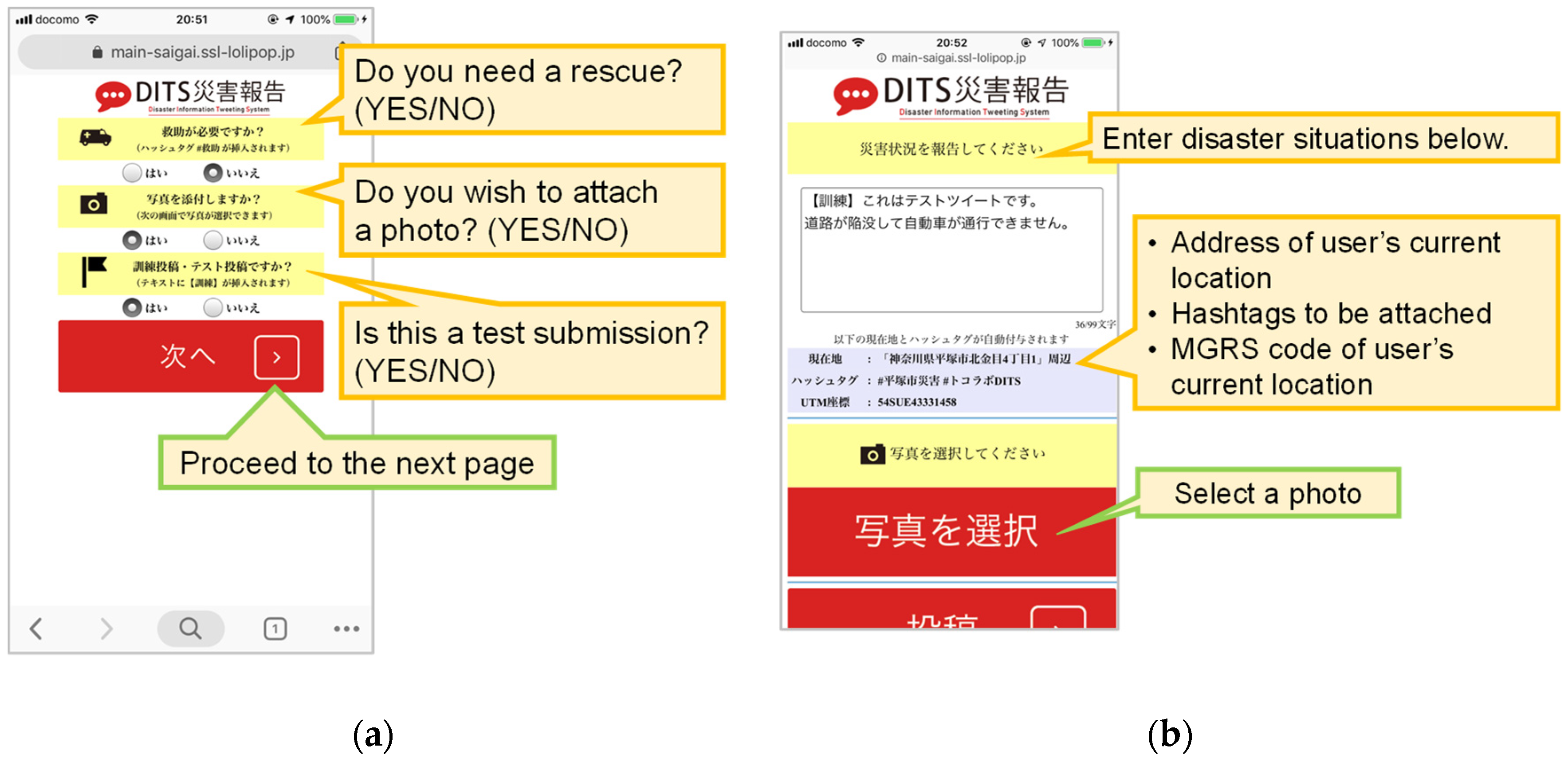
This system enables users to post disaster-related information on Twitter. Figure 2a,b show the interface of the system. The screenshot is of a web browser on the iPhone, and the DITS comprises the following features:
- Using location specification functions, such as the global positioning system, the user’s current geolocation information is acquired. Based on the acquired location information, the street address of the user’s current location, the hashtag of the form “#(municipality name) disaster,” and the Military Grid Reference System code [29] are automatically attached to the tweet.
- In cases when the user needs to be rescued, the hashtag #救助 (救助 means rescue in Japanese) can be attached to the tweet. Twitter Japan officially recommends using this hashtag when a user needs to be rescued [30].
- A photo can be attached.
Figure 3 shows an example of a tweet posted using DITS.
2.2. Disaster Information Mapping System (DIMS)
As shown in Figure 4, DIMS helps display the map of tweets posted via DITS. The DIMS comprises the following features:
- DIMS displays a map of the most recent 30 tweets posted using DITS within 20 km of the user’s location.
- The map is centered on the user’s current position.
- Depending on whether the rescue hashtag and an image are attached, the shape and color of the icon indicate the position of the tweet change.
DITS/DIMS is a system used for sharing disaster-related information such as damage-related situations and emergency requirements of victims affected by a disaster. However, in the town-watching workshops, this system is used to post and share the information in terms of disaster prevention and mitigation.
3. Town-Watching Workshop
The workshop aimed to target the community in the Makomanai area was held on 6 October 2018, at 1:30 p.m. in the Makomanai General Welfare Center at Minami Ward, Sapporo City, Hokkaido, Japan. The residential areas are very close to the workshop venue. On 6 September 2018, the Hokkaido Eastern Iburi Earthquake occurred and the shakes of the Japanese seismic intensity level 4 was observed around the workshop venue (the workshop participants mentioned that, after the earthquake, power and water supplies were cut off). Moreover, the citizens’ awareness of disaster prevention and mitigation has been increasing because Sapporo city has a redevelopment plan of the area.
We recruited the workshop participants by distributing 120 pieces of leaflets by the circular notice and sending an e-mail to 30 members of “Town development working group of Makomanai station area.” Most of the participants belonged to the group. The group’s aim is to redevelop the area via a citizen-based initiative. The group conducts meetings regularly to review the town. Table 1 shows the distribution of participants’ gender and age groups. Five professors and five students from Tokai Univerity assisted in organizing the workshop.
The objectives of the workshop were as follows:
- Objective 1. To discuss the effectiveness of SNS, such as Twitter, in the disaster situations.
- Objective 2. To review the town in terms of disaster prevention and mitigation.
The schedule of the workshop was as follows:
- 13:35–13:50 (15 min): Introduction and short lecture
- 13:50–14:50 (60 min): Town watching using DITS
- 15:00–15:15 (15 min): Group discussion using DIMS
- 15:15–15:35 (20 min): Report of group discussion
- 15:35–15:45 (10 min): Summary
3.1. Town Watching Using DITS
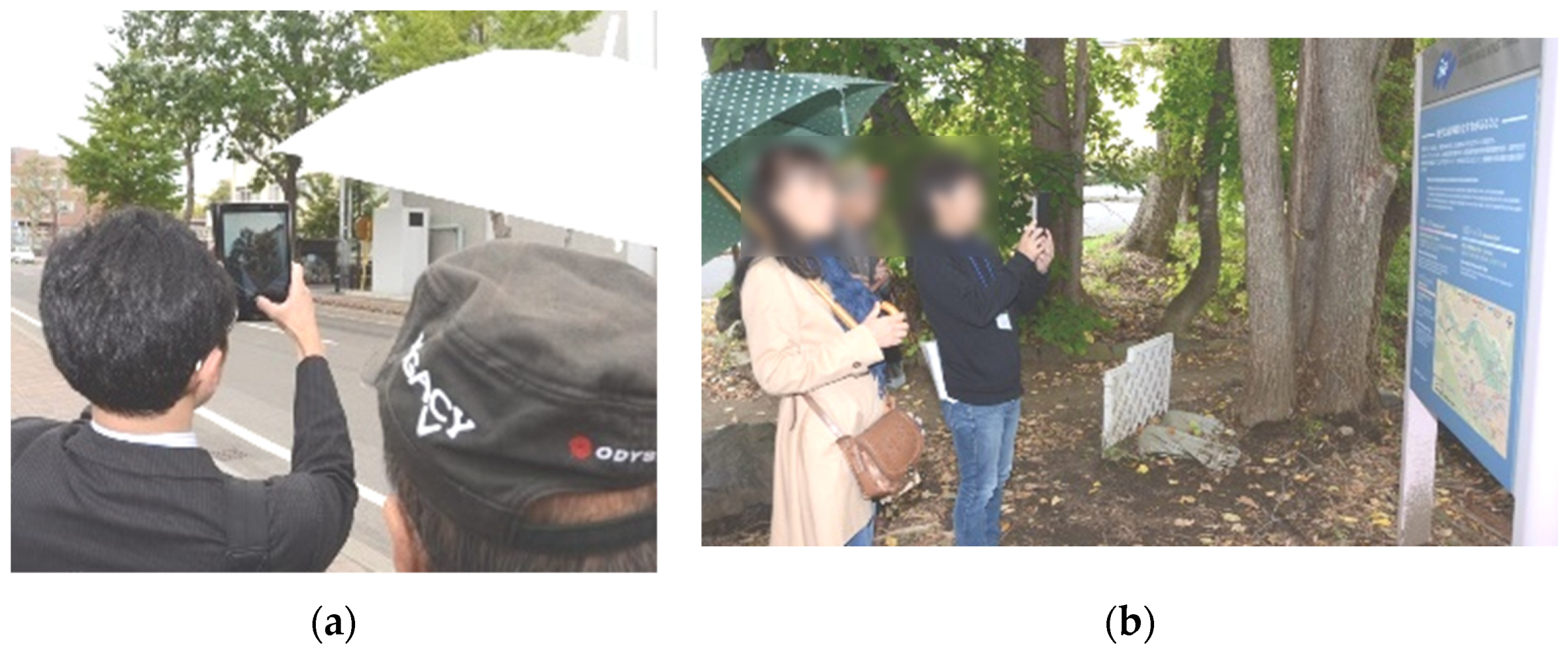
The participants were divided into seven groups of three to four people. Each group was provided an LTE-enabled tablet PC. While town watching, we asked the participants to identify notable objects or places that could facilitate disaster prevention and mitigation and post images using DITS (Figure 5). Furthermore, we requested each participant to submit two or more of these objects. Consequently, a total of 59 items were submitted:
- Dangerous places or objects: 17 items
- Useful facilities in case of disasters: 15 items
- Evacuation sites or places for the citizens: 21 items
- Objects such as foods in case of disasters: 3 items
- Others: 3 items
3.2. Group Discussion for Review Using DIMS
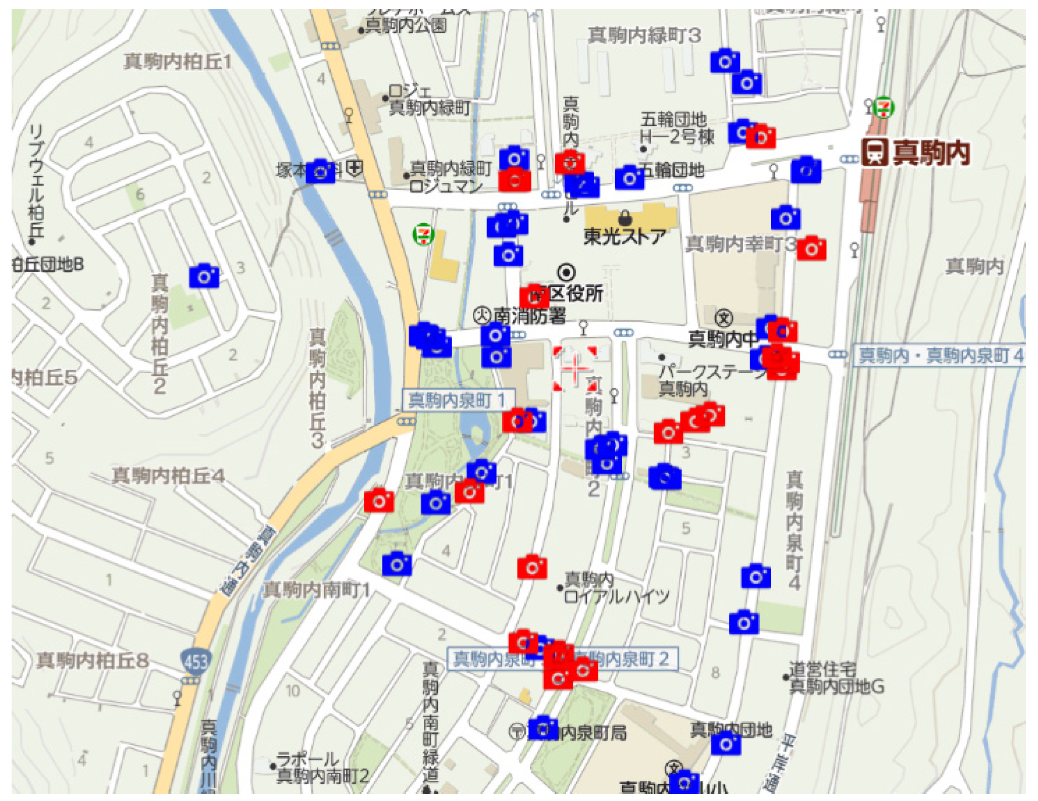
After town watching, each group reviewed the submitted tweets (Figure 9a). The tweets were displayed on Yahoo! Japan Map using DIMS (Figure 10). On the map view page, as shown in Figure 10, the records by the contributor who needs a rescue are displayed by red icons. The other posts are displayed by blue icons. In our system, when submitting a post, a user can select the rescue necessity (whether he/she needs a rescue or not) on the page shown in Figure 2a. However, we asked the participants to select any choice in this workshop, thus the icon colors did not matter in the discussion.
During the discussion, we suggested the following two topics to facilitate the discussion:
- Verify the posts submitted in town watching using DIMS and review the town for “disaster prevention and mitigation.” Then, what and where are “useful/notable places/things?” What are the issues for “disaster prevention and mitigation?”
- What kinds of posts are useful to you when you use social media such as Twitter during and after a disaster? Moreover, if the system was available when the Hokkaido Eastern Iburi Earthquake occurred, how would you utilize it?
Each group reported the summaries of the review in two minutes (Figure 9b).
3.3. Questionnaire Survey
3.3.1. Preliminary Survey
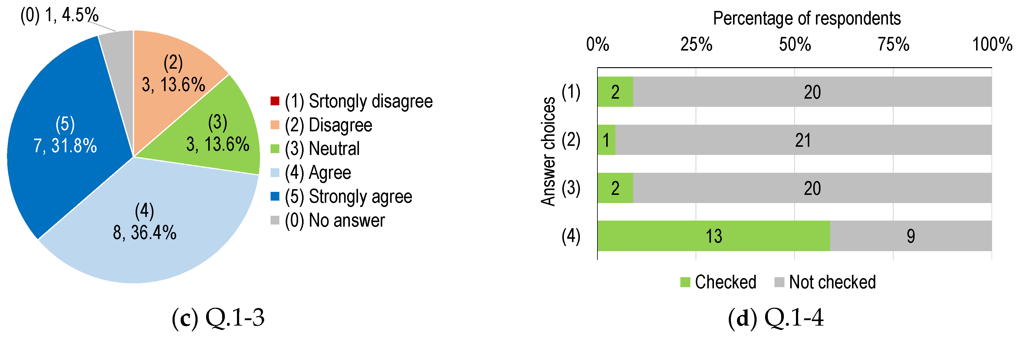
A preliminary survey was conducted before the workshop. The questions are presented below. Figure 11 shows the results for Q.1-1 to Q.1-4. Table 2 shows the answer distribution of Q.1-3 by participant characteristics (gender, age groups, and groups of smartphone owners/non-owners).
- Q.1-1: What type of cellular phone do you have?Answer choices:
- (1)
- Both smart and feature phones
- (2)
- A smartphone only
- (3)
- A feature phone (conventional cellular phone) only
- (4)
- None
- Q.1-2: What type of damage did you experience during the Hokkaido Eastern Iburi Earthquake? Please check all that apply (this question allows multiple answers).Answer choices:
- (1)
- Power was cut off
- (2)
- Water was cut off
- (3)
- Gas was cut off
- (4)
- Contact with his/her family was lost
- (5)
- Evacuation
- (6)
- Others
- (7)
- No damage
- Q.1-3: Do you think that posting on SNS, such as Twitter and Facebook, during disasters is helpful for mitigating damages?Answer choices:
- (1)
- Strongly disagree
- (2)
- Disagree
- (3)
- Neutral
- (4)
- Agree
- (5)
- Strongly agree
- Q.1-4: Select appropriate choice(s) about your experiences regarding the use of SNS during disasters. Please check all that apply (this question allows multiple answers).Answer choices:
- (1)
- I posted the pictures or texts about my suffering in a previous disaster.
- (2)
- I shared or retweeted other user’s/users’ post about my suffering in a previous disaster.
- (3)
- I shared or retweeted other user’s/users’ post since I never suffered a disaster.
- (4)
- I have never used SNS.
- Q.1-5: From the experiences of the Hokkaido Eastern Iburi Earthquake, what issues or things needed to be taken into consideration in the area?A total of 19 people responded:
- -
- Broadcasting cars should be provided to share local information.
- -
- Safe evacuation sites, food and water for an emergency, evacuation support for vulnerable people, and local disaster prevention plan are required.
- -
- Reliability of the infrastructure is important for hospitals supporting elderly people, and constant power supply is required in the houses where people with respiratory disturbance are living.
- -
- Sufficient information about evacuation sites was not provided.
- -
- Sharing information procedure about evacuation sites (e.g., whether the evacuation sites are open or not) is required.
- -
- The utilization of SNS is required.
- -
- We need to understand the routes and the location of the evacuation sites and routes to reach there in advance.
- -
- The system to support elderly people living alone has not yet been provided. Many high school or college students do not join self-government associations; therefore, a system to support these people is needed in case of emergency.
- -
- No preparation for lack of power.
- -
- Drills lecture classes are necessary several times a year to know evacuation sites and understand the quantity of required foods and drinks during the emergency.
- -
- Information sources and people’s conduct during an emergency should be known in advance. In an emergency situation, information is difficult to obtain because of the power cut off.
- -
- It was difficult to communicate relevant information.
3.3.2. Post-Survey
A post-survey was conducted after the workshop, and the survey results are presented below.
Questions Q.2-1 to Q2-6 are related to town watching and group discussion. Figure 12a shows the results for Q.2-1 and Q.2-2. Table 3 and Table 4 show the answer distribution of the questions by the participant characteristics.
- Q.2-1: Did you identify some new findings or notable information for disaster prevention via town watching? Please select one appropriate choice.
- Q.2-2: Did you identify new findings or notable information for disaster prevention via discussion after town watching? Please select one appropriate choice.Answer choices for Q.2-1 and Q.2-2:
- (1)
- Strongly disagree
- (2)
- Disagree
- (3)
- Agree
- (4)
- Strongly agree
- Q.2-3: If you select (3) Agree or (4) Strongly agree in Q.2-1 or Q.2-2, what is/are your finding/findings or notable information? Please describe in sufficient detail.Described answers: A total of 16 people responded.
- -
- There are many trees in this town. Based on the town’s features, trees are likely to be dangerous during earthquakes or typhoons because they can fall on people.
- -
- Many evacuation sites could be identified.
- -
- Old buildings and big trees should be sufficiently protected.
- -
- Many objects were identified, which could easily fall during a disaster.
- -
- In other areas, evacuation methods were displayed and they should also be introduced in this town.
- -
- There were obstacles and dangerous points at some evacuation places, which were difficult to handle because of the lack of experience related to evacuation procedures.
- -
- Very important to have daily evacuation drills as there are many dangerous locations in the town.
- Q.2-4: Have you ever experienced town watching before today’s workshop?
- Answer choices: Yes / No (first)
- Result: Yes: 9 (40.9%), No: 12 (54.5%), No answer: 1 (4.54%)
- Q.2-5: If you checked "Yes" for Q.2-4, how did you feel about town watching using DITS/DIMS as compared with the previous town watching method that did not use the system?Described answers: A total of six people responded.
- -
- The system can be used for other purposes apart from an emergency.
- -
- The address of the current location is automatically obtained as it is not required to input the address as compared with the other systems. The post of other users can be seen.
- -
- The places where the pictures were taken could be easily tracked through the online map.
- -
- Concern about battery consumption.
- Q.2-6: If you checked “No” for Q.2-4, how did you feel about the town watching using DITS/DIMS?Described answers: A total of six people responded.
- -
- Tablets are used to obtain the address of our current location automatically, which is very useful.
- -
- The system is easy to use.
- -
- Inputting characters is troublesome.
Questions Q.3-1 to Q.3-4 are with regard to DITS/DIMS. Figure 12b shows the results of Q.3-1 to Q.3-3. Table 5, Table 6 and Table 7 show the answer distribution of the questions by the participant characteristics.
- Q.3-1: Do you think that the DITS/DIMS systems are user-friendly? Please select one appropriate choice.
- Q.3-2: Would you think of using the system in the future? Please select one appropriate choice.
- Q.3-3: Do you think the system is useful in disaster situations? Please select one appropriate choice.Answer choices for Q.3-1 to Q.3-3:
- (1)
- Strongly disagree
- (2)
- Disagree
- (3)
- Agree
- (4)
- Strongly agree
- Q.3-4: If you selected (1) or (2) in Q.3-1 or Q.3-2, please describe the reasons for your choice.Described answers: Three people responded to these questions:
- -
- Elderly people cannot use this system, and the navigation text on the screen should be more user-friendly.
- -
- Tweets posted in this application and other applications should be displayed on an online map.
- -
- At the start of the workshop, the system was not useful for identifying necessary information. However, after the group discussion, this problem was overcome. In addition, depending on the contents, the coloring of the icons on the map should vary; depending on the length of the post, the size of the icons on the map should vary, and there should be a website that provides a summary of the information posted in the system.
Questions Q.4-1 to Q.4-3 focused on the use of the system or SNS in disaster situations. Figure 12c,d show the results for Q.4-2 and Q.4-3, respectively. Table 8 shows the answer distribution of Q.4-2 by the participant characteristics.
- Q.4-1: If the system was available during Hokkaido Eastern Iburi Earthquake, how would you use it?Described answers: Eight people responded to this question:
- -
- Maybe I could not afford to use it.
- -
- Obtain information about road situations such as collapses and liquefaction.
- -
- Get information about the area where the power supply has recovered.
- -
- Use the media to share local information within Minami Ward.
- Q.4-2: Do you think that posting on SNS, such as Twitter and Facebook, during disasters is helpful for mitigating damages? Please select one appropriate choice.Answer choices:
- (1)
- Strongly disagree
- (2)
- Disagree
- (3)
- Neutral
- (4)
- Agree
- (5)
- Strongly agree
- Q.4-3: Please select appropriate choices that indicate what you will do when a disaster occurs. Please check all that apply (this question allows multiple answers).Answer choices:
- (1)
- I will post pictures or texts about the situations and my suffering during a disaster.
- (2)
- I will share or retweet other user’s/users’ posts about their suffering in the disaster.
- (3)
- I will share or retweet other user’s/users’ posts about their safety in the disaster.
- (4)
- I do not want to use SNS in the future.
3.4. Discussion
In Objective 1, in the preliminary survey Q.1-3 (Figure 11c), and in the post-survey Q.4-2 (Figure 12c) respondents were asked about their intent to post on SNS during disasters and whether it was helpful for mitigating damages. Consequently, there was no significant difference among the answer distribution by participant characteristics in the questions. Moreover, there was no significant difference between the questions. However, we found the following observations:
- Three respondents answered “Disagree” to Q.1-3, however they changed to “Strongly agree” or “Agree” in Q.4-2. One of the respondents described a reason that the current information can be shared in real time by SNS.
- One respondent answered “Agree” to Q.1-3, however it changed to “Disagree” in Q.4-2. The respondent was a man in his 70s and did not describe the reason why he disagreed in the post survey. Since he had no experience to use Twitter and answered “No” to the questions about DITS/DIMS system (Q.3-1 to Q.3-3), the system might not be suitable for him.
Based on the result of Q.1–4, although almost all participants did not have experience posting information on SNS before the workshop, the number of concerned respondents increased in Q.4-3 (Figure 12d). This result indicates that these participants attempted to actively post and share information on SNS through the workshop. The result of option (4) in Q.4-3 showed that few participants did not want to use SNS in the future, indicating that the workshop educated the participants about posting useful information during a disaster on SNS.
In Objective 2, the results related to Q.2-1 and Q.2-2 (Figure 12a) show the effects of conducting a town-watching workshop. Almost all respondents answered either (4) Strongly agree or (3) Agree. This showed that the workshop contributed to the review of the town for its readiness for a disaster. Here, there was no significant difference among the answer distribution by the participant characteristics in these questions.
Regarding the operations of the DITS/DIMS (Q.3-1 to Q.3-3), > 80% of the respondents provided positive answers. There was no significant difference among the answer distribution by the participant characteristics in these questions. However, certain respondents commented that the system was not user-friendly for elderly people, and certain recommendations were provided to make the system more user-friendly. Based on the comments and suggestions, we will do our best to improve the system in the near future.
3.5. Post-Meeting
On 9 December 2018, a member of the town development working group of Makomanai station had a meeting to review the town’s readiness in light of the Hokkaido Eastern Iburi Earthquake experience in September and the town-watching workshop in October. At this meeting, participants raised the following issues.
Before the earthquake, they had reviewed the town only from the perspective of “daily life” convenience, and they had not evaluated the “emergency viewpoint.” Therefore, the workshop was a meaningful opportunity for the participants to review the town in terms of disaster prevention and mitigation. Thus, the local government should review the area and proposes a redevelopment plan.
4. Conclusions
We developed DITS/DIMS to facilitate easy posting and sharing of disaster-related information on Twitter in the previous study. In this paper, we report the outcome of the town-watching workshop using DITS/DIMS, which was held in Minami Ward, Sapporo City, Hokkaido, Japan. In the workshop, the participants reviewed the town in terms of disaster prevention and mitigation via town watching and group discussion. The post-survey result showed that the workshop educated the participants about posting useful information on social media during a disaster. From the post-meeting comments, the workshop was a meaningful opportunity for the participants to review the town in terms of disaster prevention and mitigation. In the future, we plan to hold a similar workshop in another area to provide a similar experience to people regarding town watching using DITS/DIMS as well as to educate people for information sharing using SNS. The results of the workshop will be shared among different age groups and will be displayed in different areas.
Author Contributions
Conceptualization, O.U., K.Y. and Y.M.; methodology, O.U., S.T. and S.U.; software, O.U.; validation, O.U.; formal analysis, O.U.; investigation, S.U., S.T., and O.U.; resources, K.U. and O.U.; data curation, K.U. and S.T.; writing—original draft preparation, K.U.; writing—review and editing, O.U.; visualization, K.U.; supervision, S.U., S.T., and O.U.; project administration, K.U.; funding acquisition, K.U., Y.K., S.U. and Y.M.
Funding
This research has been supported by the Tokai University Alumni Associations, the Tokai University Center for Community Engagement, and the Tokai University General Research Organization.
Acknowledgments
The authors would like to thank reviewers for giving us fruitful comments.
Conflicts of Interest
The authors declare no conflict of interest.
References
- Imran, M.; Diaz, F.; Vieweg, S. Processing Social Media Messages in Mass Emergency: A Survey. ACM Comput. Surv. 2015, 47, 67. [Google Scholar] [CrossRef]
- Kropczynski, J.; Grace, R.; Coche, J.; Jalse, S.; Obeysekare, E.; Montarnal, A.; Bénaben, F.; Tapia, A. Identifying Actionable Information on Social Media for Emergency Dispatch. In Proceedings of the ISCRAM Asia Pacific 2018, Wellington, New Zealand, 5–7 November 2018. [Google Scholar]
- Grace, R.; Halse, S.; Kropczynski, J.; Tapia, A.; Fonseca, F. Integrating Social Media in Emergency Dispatch via Distributed Sensemaking. In Proceedings of the 16th ISCRAM Conference, Valencia, Spain, 19–22 May 2019. [Google Scholar]
- Tomaszewski, B.; Judex, M.; Szarzynski, J.; Radestock, C.; Wirkus, L. Geographic Information Systems for Disaster Response: A Review. J. Homel. Secur. Emerg. Manag. 2015, 12, 1–32. [Google Scholar] [CrossRef]
- Tomaszewski, B. A Survey of GIS for Disaster Management. In Geographic Information System (GIS) for Disaster Management; CRC Press: Florida, FL, USA, 2014; pp. 1–25. [Google Scholar]
- Andrews, S.; Day, T.; Domdouzis, K.; Hirsch, L.; Lefticaru, R.; Orphanides, C. Analyzing Crowd-Sourced Information and Social Media for Crisis Management. In Application of Social Media in Crisis Management—Advanced Sciences and Technologies for Security Applications; Akhgar, B., Staniforth, A., Waddington, D., Eds.; Springer International Publishing AG: Cham, Switzerland, 2017; pp. 77–111. [Google Scholar]
- Castillo, C. Volume: Data Acquisition, Storage, and Retrieval. In Big Crisis Data; Cambridge University Press: New York, NY, USA, 2016; pp. 18–34. [Google Scholar]
- Simon, T.; Goldberg, A.; Adini, B. Socializing in emergencies—A review of the use of social media in emergency situations. Int. J. Inf. Manag. 2015, 35, 609–619. [Google Scholar] [CrossRef]
- Pourebrahim, N.; Sultana, S.; Edwards, J.; Gochanour, A.; Mohanty, S. Understanding communication dynamics on Twitter during natural disasters: A case study of Hurricane Sandy. Int. J. Disaster Risk Reduct. 2019, 37, 101176. [Google Scholar] [CrossRef]
- Alam, F.; Ofli, F.; Imran, M.; Aupetit, M. A Twitter Tale of Three Hurricanes: Harvey, Irma, and Maria. In Proceedings of the 15th ISCRAM Conference, Rochester, NY, USA, 20–23 May 2018. [Google Scholar]
- Murzintcev, N.; Cheng, C. Disaster Hashtags in Social Media. Int. J. Geo Inf. 2017, 6, 204. [Google Scholar] [CrossRef]
- Martínez-Rojas, M.; Pardo-Ferreira, M.; Rubio-Romero, J. Twitter as a tool for the management and analysis of emergency situations: A systematic literature review. Int. J. Inf. Manag. 2018, 43, 196–208. [Google Scholar] [CrossRef]
- Fujishiro, H.; Matsushita, M.; Ogasawara, M. Effective Use of Social Media in Large-Scale Disasters: The Applicability of Information Triage. Socio Inform. 2018, 6, 49–63. (In Japanese) [Google Scholar]
- Nishikawa, S.; Tanaka, N.; Utsu, K.; Uchida, O. Time Trend Analysis of “#Rescue” Tweets During and After the 2017 Northern Kyushu Heavy Rain Disaster. In Proceedings of the 2018 5th International Conference on Information and Communication Technologies for Disaster Management (ICT-DM 2018), Sendai, Japan, 4–7 December 2018. [Google Scholar]
- Nishikawa, S.; Tanaka, N.; Otaka, R.; Sato, H.; Kondo, M.; Uchida, O.; Utsu, K. Analysis of rescue request tweets in the July 2018 heavy rain disaster in Japan. IEICE Tech. Rep. 2018, 118, 43–48. (In Japanese) [Google Scholar]
- Yamada, S.; Utsu, K.; Uchida, O. An Analysis of Tweets Posted During 2018 Western Japan Heavy Rain Disaster. In Proceedings of the 2019 IEEE International Conference on Big Data and Smart Computing (BigComp 2019), Kyoto, Japan, 27 February–2 March 2019. [Google Scholar]
- Kosugi, M.; Utsu, K.; Tajima, S.; Tomita, M.; Kajita, Y.; Yamamoto, Y.; Uchida, O. Improvement of Twitter-based Disaster-related Information Sharing System. In Proceedings of the 4th International Conference on Information and Communication Technologies for Disaster Management (ICT-DM’17), Münster, Germany, 11–13 December 2017. [Google Scholar]
- Uchida, O.; Kosugi, M.; Endo, G.; Funayama, T.; Utsu, K.; Tajima, S.; Tomita, M.; Kajita, Y.; Yamamoto, Y. A real-time information sharing system to support self-, mutual-, and public-help in the aftermath of a disaster utilizing twitter. IEICE Trans. Fundam. 2016, 99, 1551–1554. [Google Scholar] [CrossRef]
- Okuma, T.; Yamamoto, K. Study on a Social Media GIS to Accumulate Urban Disaster Information: Accumulation of Disaster Information during Normal Times for Disaster Reduction Measures. Socio Inform. 2013, 2, 49–65. (In Japanese) [Google Scholar]
- Ogawa, Y.; Fernandez, L.A.; Yoshimura, T. Town watching as a tool for citizen participation in developing countries: Applications in disaster training. Int. J. Mass Emerg. Disasters 2005, 23, 5–36. [Google Scholar]
- Yoshida, Y.; Takeuchi, Y.; Shaw, R. Town watching as a useful tool in urban risk reduction in Saijo. Community Environ. Disaster Risk Manag. 2009, 1, 189–205. [Google Scholar]
- Ogawa, H. Development of A Workshop Program to Introduce Town Watching and Map Making by Using A Geographic Information System. J. Hum. Ergol. 2010, 40, 157–161. [Google Scholar]
- Takeuchi, Y.; XU, W.; Kajitani, Y.; Okada, N. Investigating Risk Communication Process for Community’s Disaster Reduction with a Framework of “Communicative Survey Method. J. Nat. Disaster Sci. 2012, 33, 49–58. [Google Scholar] [CrossRef]
- Maryanto, S.; Nadhir, A.; Santoso, R.D. Implementation of Town Watching and Development of Observatory for Community Education in Volcano Hazard Mitigation (study case at Kelud and Arjuno-Welirang volcanos, East Java, Indonesia). In Proceedings of the 4th International Conference on Frontiers of Educational Technologies (ICFET’18), Moscow, Russia, 25–27 January 2018. [Google Scholar]
- Shaw, R.; Takeuchi, Y. Town Watching Handbook for Disaster Education: Enhancing Experimental Learning; EU, UNISDR, 2009. Available online: https://www.unisdr.org/we/inform/publications/12062 (accessed on 1 April 2019).
- Tajima, S.; Murakami, Y.; Uchida, O.; Kajita, Y. The Development of a Creation System for a Disaster-avoidance Map Using a Smartphone and the Evaluation of Educational Practice. Jpn. Soc. Educ. Technol. 2017, 41, 85–88. (In Japanese) [Google Scholar]
- Enokida, S.; Yoshino, T.; Fukushima, T.; Sugimoto, K.; Egusa, N. An Integrated Support System for Disaster Prevention Map-Making Using Town-Walk Information Gathering. In Proceedings of the Collaboration Technologies and Social Computing (CollabTech 2018), Costa de Caparica, Portugal, 5–7 September 2018. [Google Scholar]
- Uchida, O.; Tajima, S.; Kajita, Y.; Murakami, Y.; Utsu, K.; Yamada, S. Disaster Prevention Education Using Disaster Information Sharing System DITS/DIMS. In Proceedings of the 2018 IEICE Engineering Sciences Society Conference, Kanazawa, Japan, 11–14 September 2018. (In Japanese). [Google Scholar]
- Military Map Reading 201. Available online: http://earth-info.nga.mil/GandG/coordsys/mmr201.pdf (accessed on 30 April 2019).
- @TwitterLifeline, Twitter. Available online: https://twitter.com/TwitterLifeline/status/1016519147738419201 (accessed on 30 April 2019).
Figure 1.
Screenshot of the initial page of Disaster Information Tweeting/Mapping System (DITS/DIMS).
Figure 1.
Screenshot of the initial page of Disaster Information Tweeting/Mapping System (DITS/DIMS).

Figure 2.
Screens of DITS: (a) Screen for selecting options for tweets to be posted and (b) Screen for entering comments and selecting a photo that has to be attached.
Figure 2.
Screens of DITS: (a) Screen for selecting options for tweets to be posted and (b) Screen for entering comments and selecting a photo that has to be attached.

Figure 3.
An example tweet posted using DITS.

Figure 4.
Screenshot of DIMS.

Figure 5.
Town watching (the pictures are provided by the Tokai NewsPress). (a) A participant is taking a picture of an old tree; (b) A participant is taking a picture of a guide board.
Figure 5.
Town watching (the pictures are provided by the Tokai NewsPress). (a) A participant is taking a picture of an old tree; (b) A participant is taking a picture of a guide board.

Figure 6.
Example tweets of dangerous places or objects.

Figure 7.
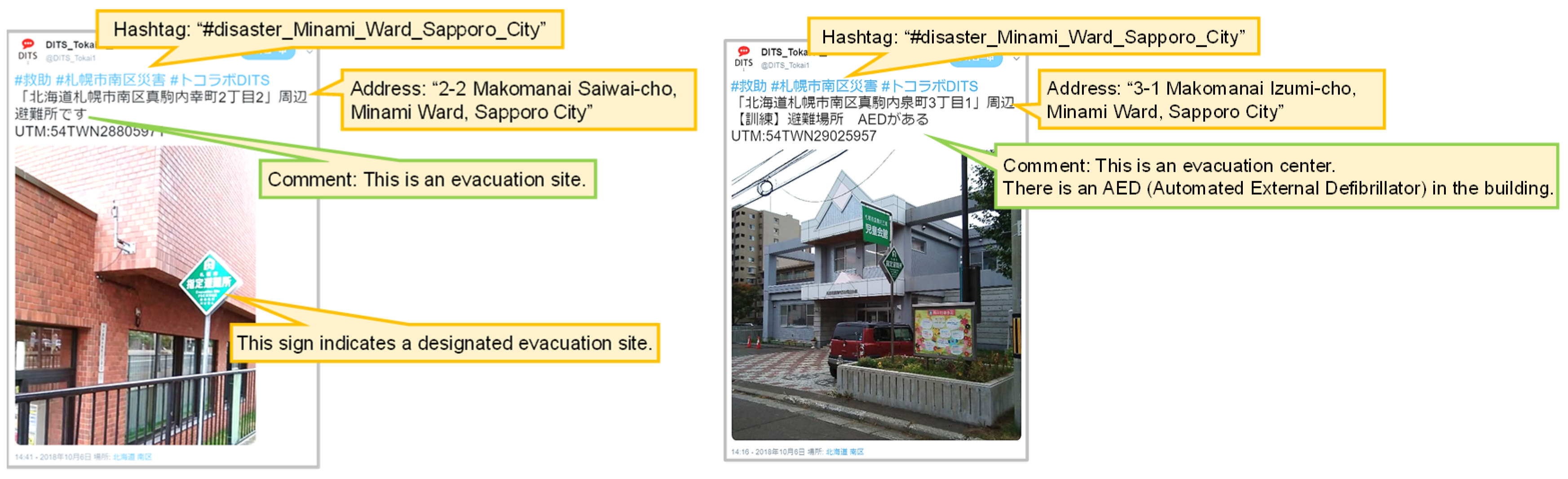
Example tweets of useful facilities in case of disasters.

Figure 8.
Example tweets of evacuation sites or places for the citizens.

Figure 9.
Group discussion for review using DIMS (the pictures are provided by the Tokai News-Press): (a) Group discussion; (b) Report of group discussion.
Figure 9.
Group discussion for review using DIMS (the pictures are provided by the Tokai News-Press): (a) Group discussion; (b) Report of group discussion.

Figure 10.
Map view in DIMS: Posts are mapped on Yahoo! Japan map.

Figure 11.
Preliminary results survey: (a) Q.1-1; (b) Q.1-2; (c) Q.1-3; (d) Q.1-4.


Figure 12.
Results for post-survey: (a) Q.2-1 to Q.2-2; (b) Q.3-1 to Q.3-3; (c) Q.4-2; (d) Q.4-3.


Table 1.
Ages and gender distribution of participants.
| Age Groups | Total | Gender | |
|---|---|---|---|
| Males | Females | ||
| 20s | 2 | 2 | 0 |
| 30s | 3 | 3 | 0 |
| 40s | 0 | 0 | 0 |
| 50s | 4 | 2 | 2 |
| 60s | 5 | 2 | 3 |
| 70s | 8 | 4 | 4 |
| Total | 22 | 13 | 9 |
Table 2.
Answer distribution of Q.1-3 by the participant characteristics.
| Total | Gender | Age Groups | Groups of Smartphone Owners/Non-Owners | ||||
|---|---|---|---|---|---|---|---|
| Males | Females | 20s–50s (Around Working Ages) | 60s and 70s | Owners | Non-Owners | ||
| (5) Strongly Agree | 7 | 5 | 2 | 5 | 2 | 6 | 1 |
| (4) Agree | 8 | 4 | 4 | 2 | 6 | 5 | 3 |
| (3) Neutral | 3 | 1 | 2 | 1 | 2 | 2 | 1 |
| (2) Disagree | 3 | 3 | 0 | 1 | 2 | 3 | 0 |
| (1) Strongly disagree | 0 | 0 | 0 | 0 | 0 | 0 | 0 |
| Total of respondents | 21 | 13 | 8 | 9 | 12 | 16 | 5 |
| No answer | 1 | 0 | 1 | 0 | 1 | 0 | 1 |
| Average score in respondents | 3.90 | 3.85 | 4.00 | 4.22 | 3.67 | 3.88 | 4.00 |
Table 3.
Answer distribution of Q.2-1 by the participant characteristics.
| Total | Gender | Age Groups | |||
|---|---|---|---|---|---|
| Males | Female | 20s–50s (Around Working Ages) | 60s and 70s | ||
| (4) Strongly Agree | 10 | 6 | 4 | 7 | 3 |
| (3) Agree | 12 | 7 | 5 | 2 | 10 |
| (2) Disagree | 0 | 0 | 0 | 0 | 0 |
| (1) Strongly disagree | 0 | 0 | 0 | 0 | 0 |
| Total of respondents | 22 | 13 | 9 | 9 | 13 |
| No answer | 0 | 0 | 0 | 0 | 0 |
| Ave. score in respondents | 3.45 | 3.46 | 3.44 | 3.78 | 3.23 |
Table 4.
Answer distribution of Q.2–2 by the participant characteristics.
| Total | Gender | Age Groups | |||
|---|---|---|---|---|---|
| Males | Female | 20s–50s (Around Working Ages) | 60s and 70s | ||
| (4) Strongly Agree | 9 | 5 | 4 | 6 | 3 |
| (3) Agree | 11 | 6 | 5 | 2 | 9 |
| (2) Disagree | 0 | 0 | 0 | 0 | 0 |
| (1) Strongly disagree | 0 | 0 | 0 | 0 | 0 |
| Total of respondents | 20 | 11 | 9 | 8 | 12 |
| No answer | 2 | 2 | 0 | 1 | 1 |
| Ave. score in respondents | 3.45 | 3.45 | 3.44 | 3.75 | 3.25 |
Table 5.
Answer distribution of Q.3-1 by the participant characteristics.
| Total | Gender | Age Groups | Groups of Smartphone Owners/Non-Owners | ||||
|---|---|---|---|---|---|---|---|
| Males | Females | 20s–50s (Around Working Ages) | 60s and 70s | Owners | Non-Owners | ||
| (4) Strongly Agree | 0 | 0 | 0 | 0 | 0 | 0 | 0 |
| (3) Agree | 14 | 9 | 5 | 6 | 8 | 11 | 3 |
| (2) Disagree | 3 | 3 | 0 | 1 | 2 | 2 | 1 |
| (1) Strongly disagree | 0 | 0 | 0 | 0 | 0 | 0 | 0 |
| Total of respondents | 17 | 12 | 5 | 7 | 10 | 13 | 4 |
| No answer | 5 | 1 | 4 | 2 | 3 | 3 | 2 |
| Average score in respondents | 2.82 | 2.75 | 3.00 | 2.86 | 2.80 | 2.85 | 2.75 |
Table 6.
Answer distribution of Q.3-2 by the participant characteristics.
| Total | Gender | Age Groups | Groups of Smartphone Owners/Non-Owners | ||||
|---|---|---|---|---|---|---|---|
| Males | Females | 20s–50s (Around Working Ages) | 60s and 70s | Owners | Non-Owners | ||
| (4) Strongly Agree | 3 | 3 | 0 | 2 | 1 | 3 | 0 |
| (3) Agree | 10 | 6 | 4 | 2 | 8 | 8 | 2 |
| (2) Disagree | 4 | 4 | 0 | 3 | 1 | 3 | 1 |
| (1) Strongly disagree | 0 | 0 | 0 | 0 | 0 | 0 | 0 |
| Total of respondents | 17 | 13 | 4 | 7 | 10 | 14 | 3 |
| No answer | 5 | 0 | 5 | 2 | 3 | 2 | 3 |
| Average score in respondents | 2.94 | 2.92 | 3.00 | 2.86 | 3.00 | 3.00 | 2.67 |
Table 7.
Answer distribution of Q.3-3 by the participant characteristics.
| Total | Gender | Age Groups | Groups of Smartphone Owners/Non-Owners | ||||
|---|---|---|---|---|---|---|---|
| Males | Females | 20s–50s (Around Working Ages) | 60s and 70s | Owners | Non-Owners | ||
| (4) Strongly Agree | 3 | 3 | 0 | 2 | 1 | 3 | 0 |
| (3) Agree | 15 | 9 | 6 | 5 | 10 | 11 | 4 |
| (2) Disagree | 1 | 1 | 0 | 0 | 1 | 0 | 1 |
| (1) Strongly disagree | 0 | 0 | 0 | 0 | 0 | 0 | 0 |
| Total of respondents | 19 | 13 | 6 | 7 | 12 | 14 | 5 |
| No answer | 3 | 0 | 3 | 2 | 1 | 2 | 1 |
| Average score in respondents | 3.11 | 3.15 | 3.00 | 3.29 | 3.00 | 3.21 | 2.80 |
Table 8.
Answer distribution of Q.4-2 by the participant characteristics.
| Total | Gender | Age Groups | Groups of Smartphone Owners/Non-Owners | ||||
|---|---|---|---|---|---|---|---|
| Males | Females | 20s–50s (Around Working Ages) | 60s and 70s | Owners | Non-Owners | ||
| (5) Strongly Agree | 7 | 6 | 1 | 4 | 3 | 7 | 0 |
| (4) Agree | 7 | 4 | 3 | 2 | 5 | 5 | 2 |
| (3) Neutral | 5 | 2 | 3 | 3 | 2 | 4 | 1 |
| (2) Disagree | 1 | 1 | 0 | 0 | 1 | 0 | 1 |
| (1) Strongly disagree | 0 | 0 | 0 | 0 | 0 | 0 | 0 |
| Total of respondents | 20 | 13 | 7 | 9 | 11 | 16 | 4 |
| No answer | 2 | 0 | 2 | 0 | 2 | 0 | 2 |
| Average score in respondents | 4.00 | 4.15 | 3.71 | 4.11 | 3.91 | 4.19 | 3.25 |
© 2019 by the authors. Licensee MDPI, Basel, Switzerland. This article is an open access article distributed under the terms and conditions of the Creative Commons Attribution (CC BY) license (http://creativecommons.org/licenses/by/4.0/).
Share and Cite
MDPI and ACS Style
Utsu, K.; Ueta, S.; Tajima, S.; Kajita, Y.; Murakami, Y.; Uchida, O. Town-Watching Workshop Using Disaster Information Tweeting and Mapping System. Future Internet 2019, 11, 150. https://doi.org/10.3390/fi11070150
AMA Style
Utsu K, Ueta S, Tajima S, Kajita Y, Murakami Y, Uchida O. Town-Watching Workshop Using Disaster Information Tweeting and Mapping System. Future Internet. 2019; 11(7):150. https://doi.org/10.3390/fi11070150
Chicago/Turabian StyleUtsu, Keisuke, Shun Ueta, Sachi Tajima, Yoshitaka Kajita, Yuji Murakami, and Osamu Uchida. 2019. "Town-Watching Workshop Using Disaster Information Tweeting and Mapping System" Future Internet 11, no. 7: 150. https://doi.org/10.3390/fi11070150
Note that from the first issue of 2016, this journal uses article numbers instead of page numbers. See further details here.