1. Introduction
Owing to global warming caused by climate change, various environmental problems are intensifying in urban areas, such as increased heat waves, tropical nights, air pollution and flooding [
1,
2]. Moreover, the environmental problems in urban areas were even more severe, due to an artificial surface, reduced green space, and air pollution triggered by excessive urban development [
3,
4,
5,
6]. Especially, urban heat islands, which occur when the temperature in the urban area is significantly higher than the surrounding areas, is becoming more serious than and intensifies more during the night than in the daytime. It not only affects human habitability, but also may lead to the death of urban residents in serious cases [
7]. In response to these urban environmental problems, sustainable and environmental cities are proposed as the basic directions for creating pleasant cities. In particular, among the factors for establishing eco-friendly cities, plans have been carried out for a smooth cycle of wind and energy that can continuously control urban temperatures and pollution [
8]. Wind in the urban area lowers the physiological equivalent temperature (PET), being in the background for thermal comfort and discomfort [
9]. It also disperses the air pollutants in the city to improve the urban atmospheric environment [
10]. Therefore, in order to establish eco-friendly cities, it is necessary to secure a wind corridor and it is important to identify areas where local cold air is generated and can smoothly enter cities. Local cold air refers to a volume of air near the surface, which has a lower temperature than the air above it, due to the energy circulation occurring on the Earth’s surface [
10]. Generally, local cold air which means nocturnal drainage is generated by the afternoon-evening cooling process, more precisely in the clear nighttime without clouds. It is used as a concept similar to the meaning of fresh air not contaminated by air pollution and it varies depending on weather conditions, land use, and topography. In addition, the passage of cold and fresh air flowing into the city is known as the wind corridor. Cold air is most commonly produced in a barren land, and it is known to be low in forests, because in forests there is not a big difference in the daily temperature range. However, there are opinions that the degree of cold air generation in forests is undervalued, and the cold air generated in forests is easy to travel on sloping surfaces, such as mountain valleys, due to their geographical conditions [
11]. Accordingly, foreign countries have been paying attention to the local cold air generated from mountains located outside the city for a long time and tried to establish the city through a wind corridor plan that draws cold air into the city.
In Stuttgart and Freiburg, two mountainous cities in Germany, the generation and flow of cold air occurring in the mountains on the outskirts of the cities were simulated, and the characteristics of the local cold air were identified [
12]. Based on this, the local governments suggested a thorough urban management plan to ensure a smooth supply of cold air into the cities [
13]. Additionally, various studies are underway to assess source localities and flow of cold air, and to devise an effective management approach for the use of cold air based on local cold air analyses. Examples include analyses of factors influencing nighttime cold air generation, such as mountain gorges, valleys, mountain canopies, and lakes [
14,
15,
16,
17,
18,
19], and studies on thermodynamic characteristics of the urban nighttime cooling function [
5].
As the same time, attention in securing wind corridors in urban areas has increased in Korea, and the local cold air, which is generated the outskirts of the city, attracted attention especially [
20]. According to the National Sustainability Report [
21], sustainable forest management was promoted as one of the strategies for enhancing environmental sustainability. In this regard, the Korea Forest Service established the Basic Plan for Mountain Management [
22]. It clearly states the need to expand the cooling function of mountains in order to mitigate the urban heat islands and tropical weather. In other words, in order to flow the local cold air generated from mountains outskirts of the urban areas into the urban areas, it suggested that it is necessary to investigate the path of the local cold air that flows into the urban area and mountains generating the cooling function and prepare an integrated management plan. Mountains cover 63% of Korea, Korean mountains consist of the Baekdudaegan and 13 Jeongmaeks outstretching from the Baekdudaegan. The Jeongmaek is the axis of the main mountain ranges of Korea and is characterized by forming near urban areas. Therefore, in densely populated Korean urban areas with difficulty in expanding large-scale greenery [
7], using Jeongmaeks with good geographical and topographical conditions has the potential to improve the urban thermal environment [
23]. In plans, the local cold can be effectively utilized to draw in fresh air from the Jeongmaek to the city and induce local air circulation. What should be preceded is to identify areas where the local cold air occurs and identify where the generated air flows and where it stagnates. However, most domestic studies have only focused on surveying wind changes in inner-city areas and suggesting its applicability in urban planning [
24,
25,
26,
27,
28,
29].
Therefore, we aimed to analyze the characteristics of local cold air generated during the nighttime according to topographical characteristics and land use. For this purpose, we selected areas of the Honam Jeongmaek as a case study among 13 the Jeongmaeks located on the Korean Peninsula and tried to identify the local cold air flow and the altitude of the local cold air layer in urban areas with various characteristics. Finally, we suggested management strategies for maximizing the use of local cold air by region. This study can be used for the planning of ventilation paths for the climate-friendly urban development in the Honam Jeongmaek region. In addition, it is expected to be useful for policy development related to the Jeongmaek management for quantitative expansion and conservation of cooling functional mountain regions.
2. Methodology
2.1. Study Area
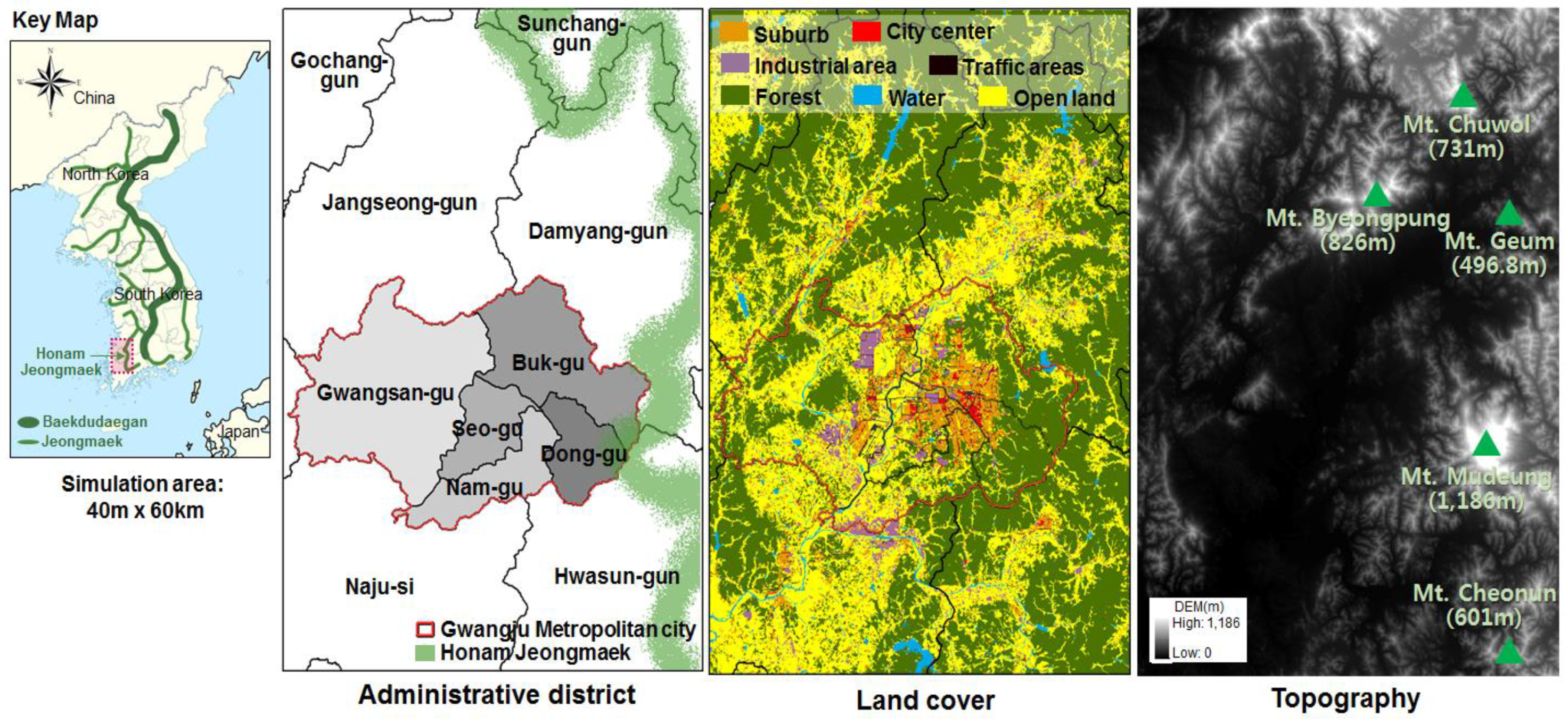
In order to identify the areas where local air is generated and to analyze the effect on nearby urban areas, the area of Honam Jeongmaek, located in the southwestern part of the Korean peninsula, was selected as our study site (
Figure 1). The Honam Jeongmaek is an important ecological axis of Jeollanam-do, and various cities are formed along the Jeongmaek, due to the geographical characteristics extending to the north and south. Therefore, it is expected to utilize the cooling function that varies depending on the geographical feature of the mountain area and the characteristics of various cities. In this study, simulation area was set up to include Gwangju Metropolitan City, which is a large city with an area of 501.2 km
2 and a population of 1,463,770 as of 2017, as well as Jangseong-gun, Damyang-gun, Naju-si and Hwasun-gun, which are major industries in agriculture. In particular, Gwangju Metropolitan City is an area where recent temperatures are causing serious problems, such as heat waves and tropical nights. In addition, it is expected that the ventilation will be difficult, due to the basin shape, in which the city area is lower than the surrounding area, and the problems of the thermal environment and air pollution will worsen in the future.
The study area was 40 km × 60 km, and included the entire Gwangju Metropolitan City, as well as part of Jangseong-gun, Damyang-gun, Hwasun-gun, and Naju-si. To the east of the study site sits the Honam Jeongmaek, and the main mountains are Mt. Mudeung (1186 m), Mt. Byeongpung (826 m), and Mt. Cheonun (601 m). Most of the flatlands stretching from the southwest to the northeast are agricultural areas, while most of the Gwangju Metropolitan City area has been urbanized, and the Yeongsan River runs through the urban area from north to south.
2.2. Analysis of the Cold Airflow and Altitude of the Cold Air Layer
Among various models available for cold air analysis, the KALM (Kaltluftabflussmodell) [
30], developed in Germany, was applied. The KALM model calculates the amount and flow of cold air generated during the nighttime without winds. It is useful for analyzing cold airflows over complex topography, such as that in Korea. Therefore, the KALM model was applied to many Korean cities, such as the Pocheon area in Gyeonggi-do [
31], the Nakdong Jeongmaek area [
23], the part of Daegu Metropolitan City [
32], etc.
The equation used in the KLAM model is shown in Formula (1).
Here, u represents the horizontal velocity vector of cold air; h represents the altitude of the cold air layer; H represents the altitude of the upper cold air layer; c is the coefficient of friction; and q is the cold air generation rate. represents the amount of gravity reduced according to the difference between the surrounding temperature and layer-averaged temperature difference . The average horizontal velocity of each layer is expressed by the cold air horizontal velocity vectors u and v.
Formula (1) solved by Formula (2) is calculated as follows:
Here,
indicates the inverse time scale, and
α indicates the slope of a surface. The values of the coefficient of friction
c and the cold air generation rate q vary according to land use, and thus depend on the target sites where they are applied. The KALM model provides default values of the variables, including coefficient of friction (the length of surface roughness) and cold air generation rate, for seven types of land use. However, these values are set based on urban structure characteristics of average German cities. Therefore, the present study applied coefficient of friction and cold air generation rate reflected the characteristics of Korean city structures [
11,
33]. As for temperature difference and zero-plane displacement height, the values provided in the KALM model were used.
Table 1 shows the values of the variables applied in the present study according to land use.
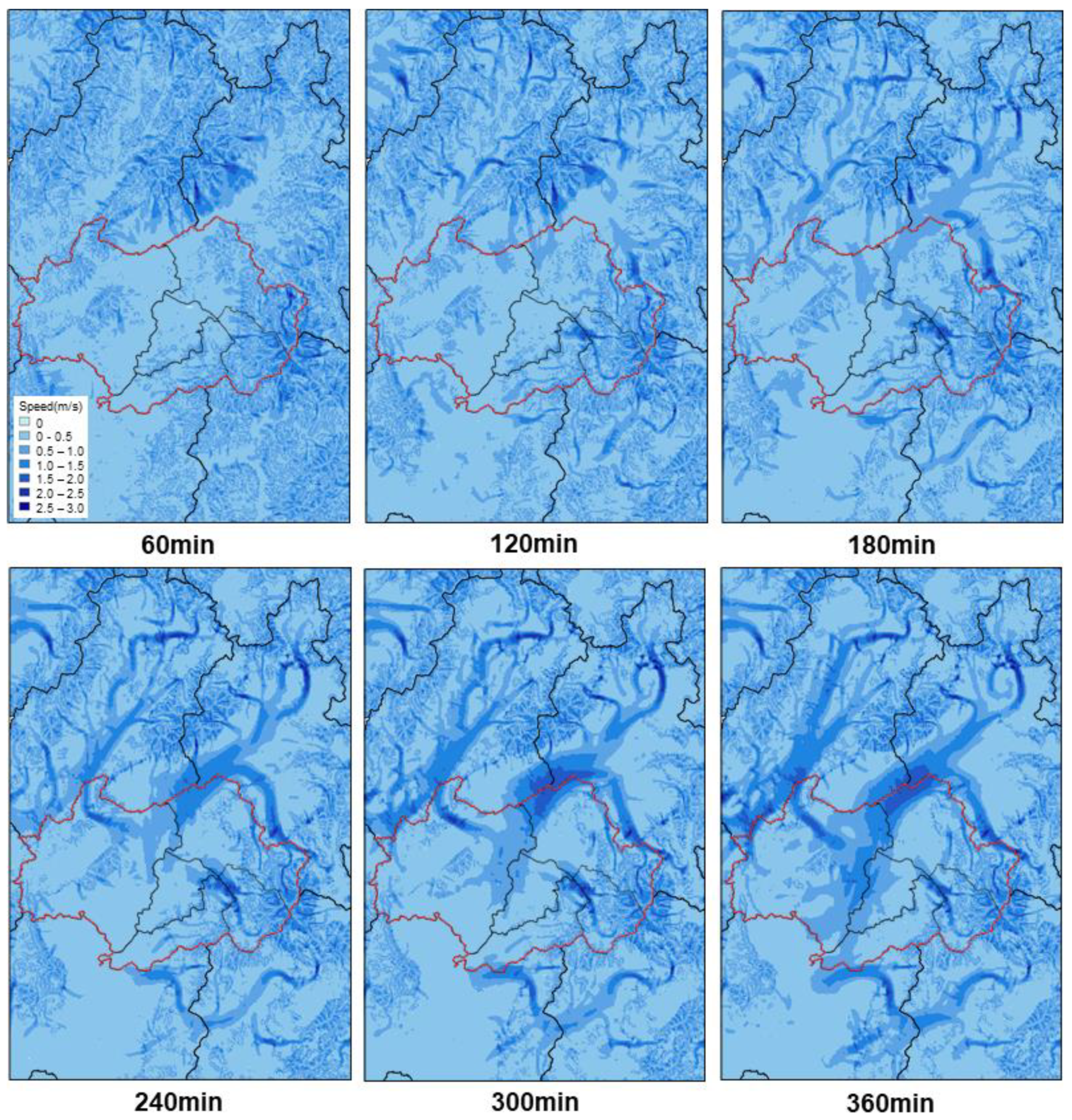
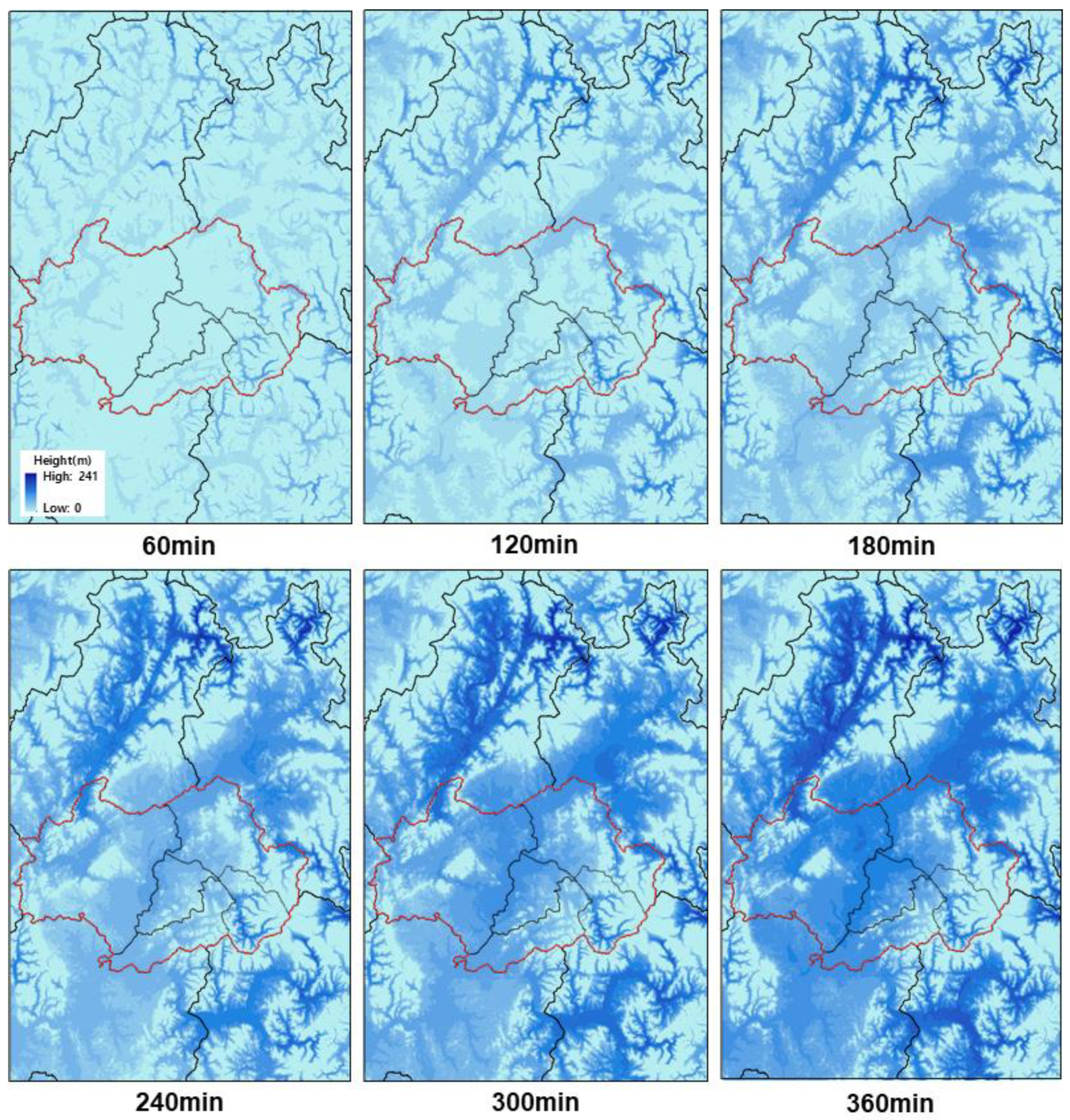
The major data input in this study was land cover information, which we classified into seven types (Suburb, Forest, Open land, City center, Water, Traffic area, and Industrial area) to suit our model based on the 22 land cover types provided by the Ministry of Environment. The KALM simulation was done for six hours from after sunset to before sunrise when the local cold air generation takes place. The model calculated the hourly (60, 120, 180, 240, 300, and 360 min) cold airflow velocity and the hourly altitude of the cold airflow. Based on this, the hourly average and maximum values for velocity and altitude were calculated. The resolution was configured at 100 m.
2.3. Analysis of Effect of the Cooling Function during Nighttime
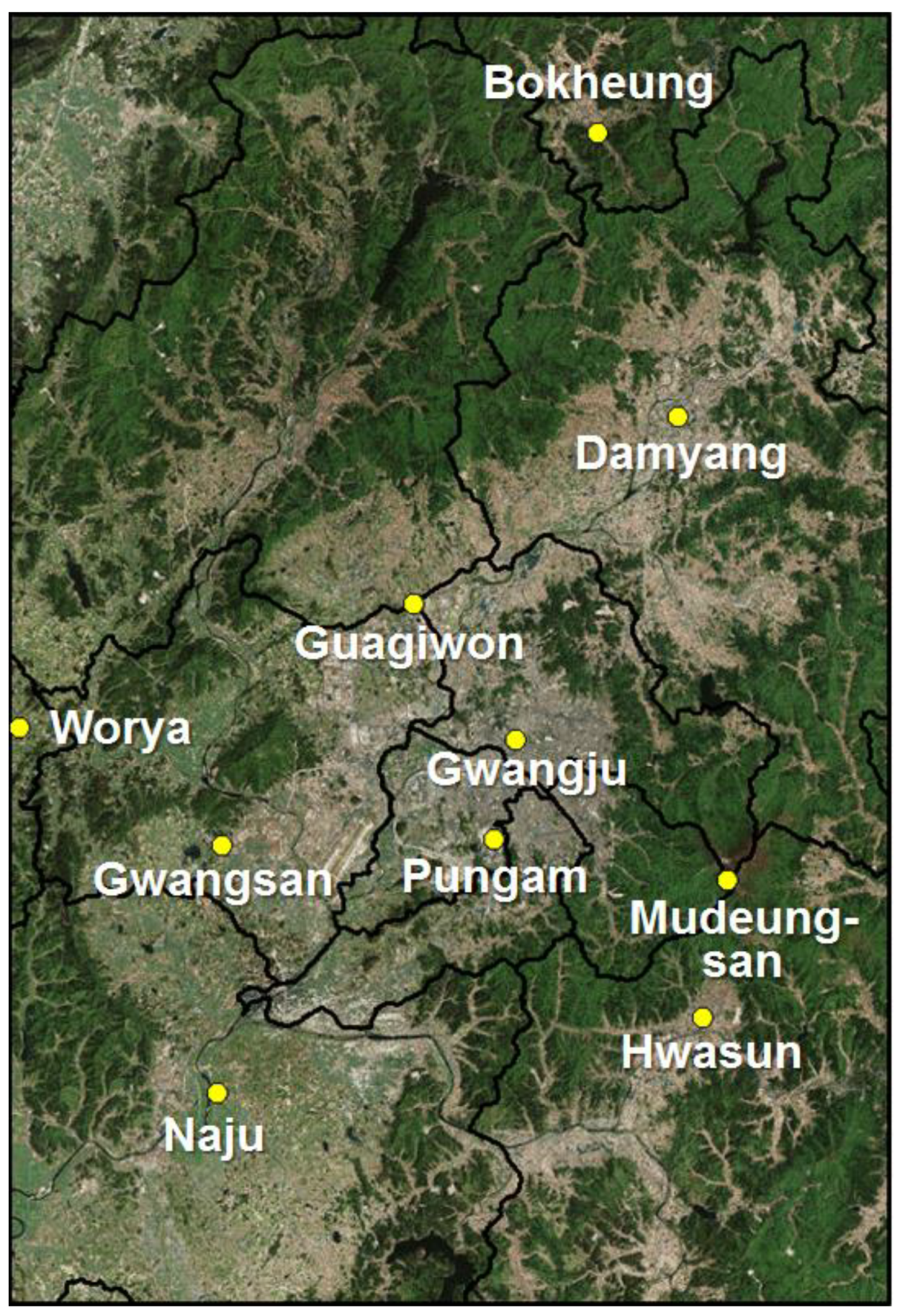
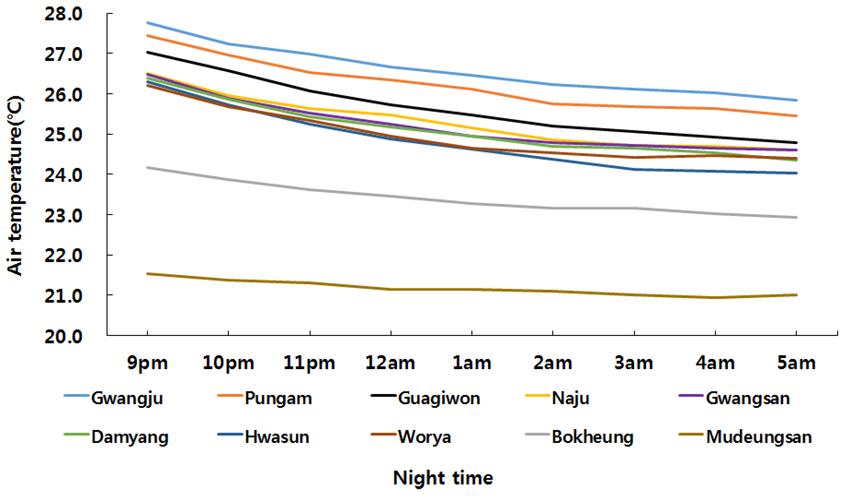
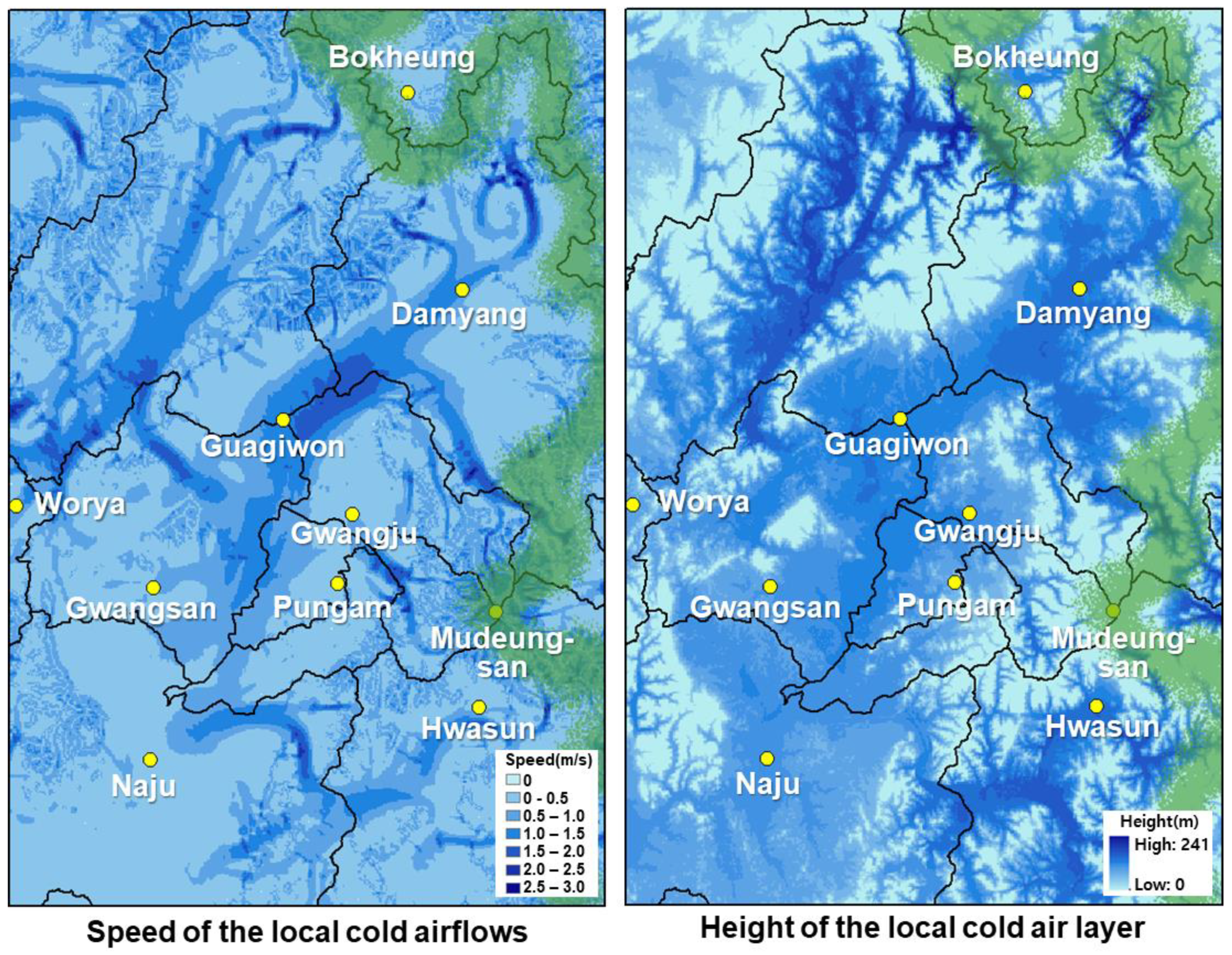
This study tried to verify the effect of the cold air by confirming the nighttime temperature difference between 21:00 after sunset and 05:00 before sunrise. Actual observations were used to verify the effect of the local cold air produced by mountains. We used data from ten automatic weather stations (AWSs) in the analysis area (
Figure 2). Except for cloudy and rainy days, average temperature values in July 2017 were calculated, and the degree of temperature reduction for each AWS was compared. It is expected that the effect of nighttime temperature reduction will be great in areas with cold air velocity and the cold air layer.
4. Management Strategies for Securing Cooling Function based on the Local Cold Air Characteristics
4.1. Characteristics of the Local Cold Air by Administrative Areas
4.1.1. Gwangju Metropolitan City
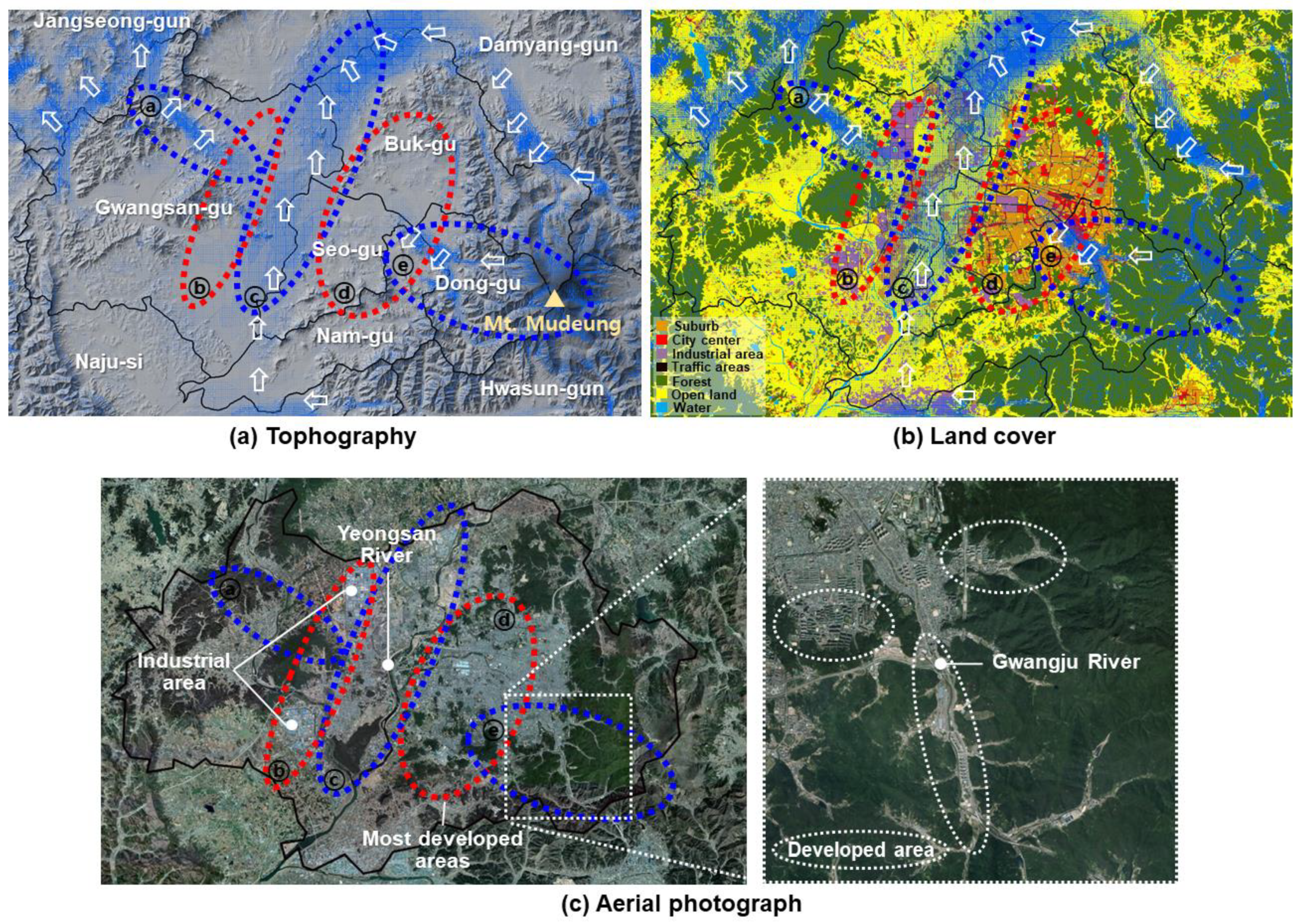
The detailed airflows of Gwangju Metropolitan City are shown in
Figure 8. The cold air flowing from Naju-si to the south of Gwangju is passing strongly along the Yeongsan River to the north (ⓒ). The local cold air generated in Mt. Mudeung influenced certain areas of the densely developed area in Dong-gu (ⓔ), whereas the flow was relatively weak in Buk-gu, Seo-gu and Nam-gu (ⓓ). This is likely not only due to the effect of the flat topography of the area, but also due to the disturbance of air circulation as vortices were formed around high-rise buildings in the developed areas. Even in the case of Gwangsan-gu, the local cold air generation was active, but it does not affect the industrial area (ⓑ).
4.1.2. Adjacent Areas
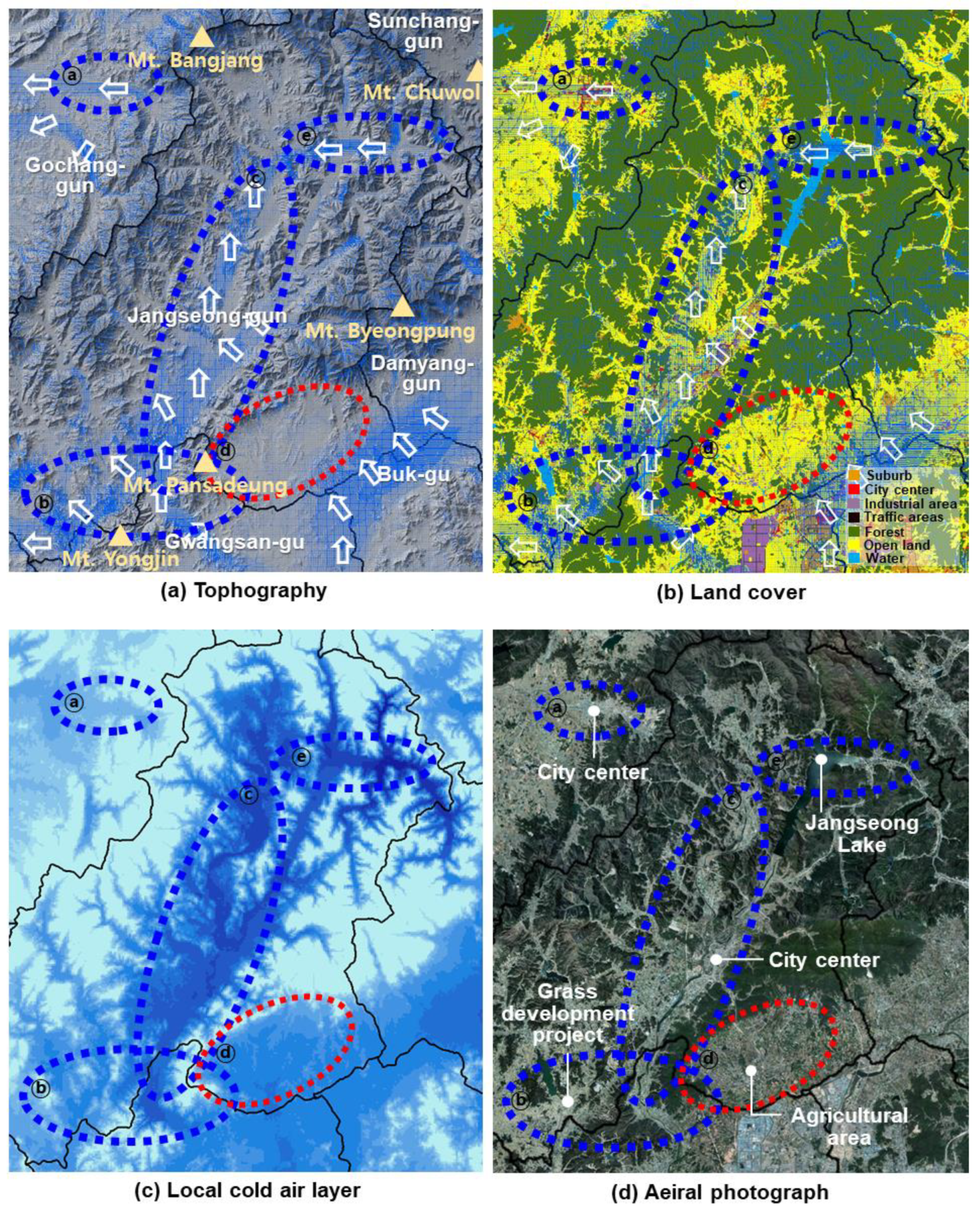
Detailed results for the surrounding areas are as follows. In the case of Jangseong-gun, the local cold air flow generated in the eastern forests, including Mt. Chuwol and Mt. Byeongpung, was mostly smooth and also the local cold air layer was highly accumulated (
Figure 9). The flow produced from Mt. Cheonun, in the southeast of the study area, joined with the flows Mt. Yongjin and Mt. Pansandeung and flowed strongly northwards (ⓑ, ⓒ). The airflows also joined with the flows expanded along the Jangseong Lake and flowed smoothly toward the center of Jangseong-gun (ⓔ). Samgye-myeon is the site of a grass development project, which is the key project of Jangseong-gun. It is expected that cold air was not stagnant in this area, because of sufficient air circulation (ⓑ). On the other hand, in some of the agricultural areas in Jiwon-myeon and Nam-myeon, the local cold air flows were weak, but the local cold air layers were thick. This area needs management strategies for cold air stagnates (ⓓ). It is expected that the local cold air can contribute to improving the heat environment in Gochang-gun, as the local cold air from the Mt. Bangjang areas flowed into the city center of Gochang-gun smoothly (ⓐ).
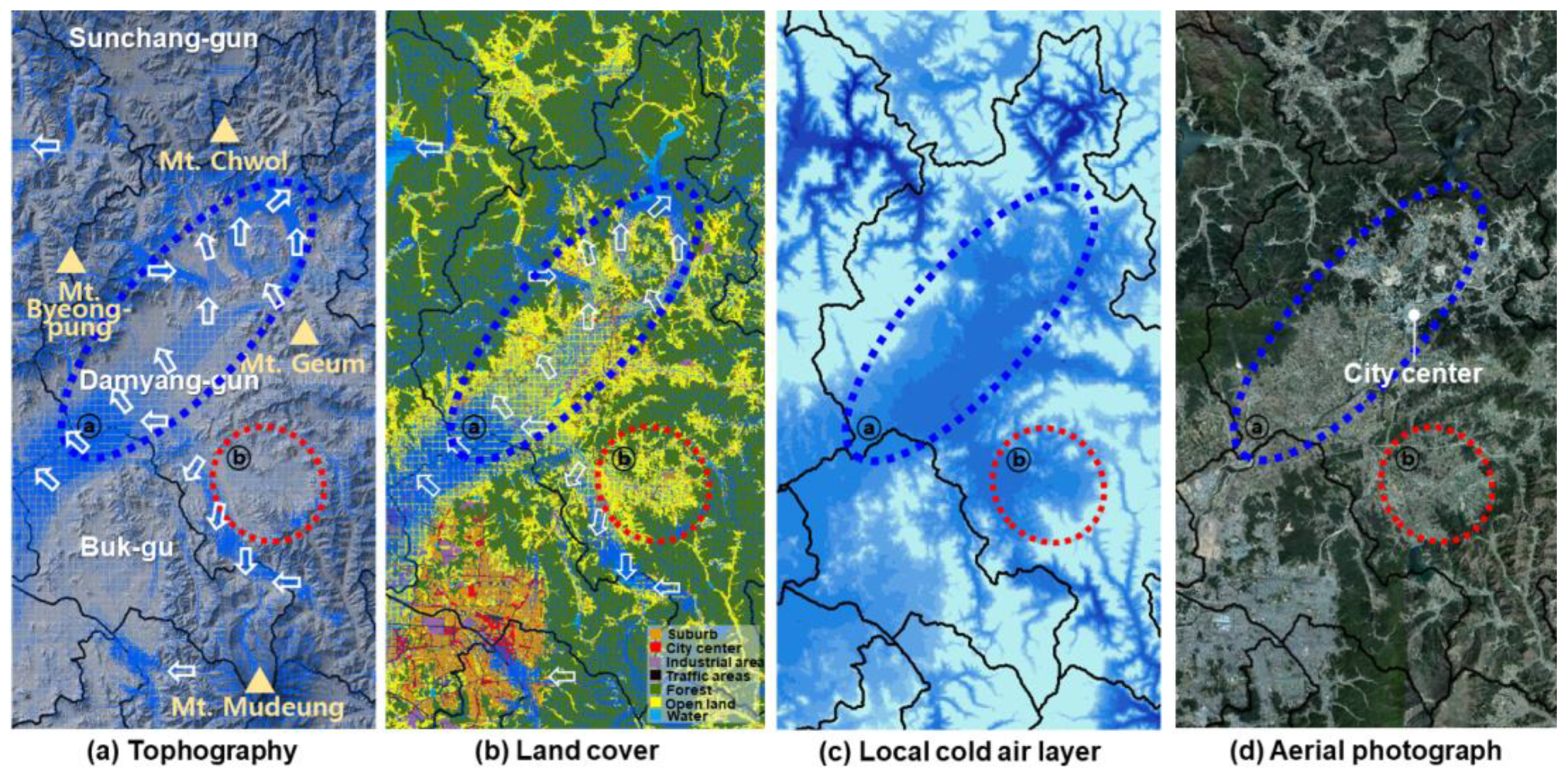
Figure 10 shows the detailed flow of local cold air in Damyang-gun. The local cold air, generated in Buk-gu of Gwangju, in the south, was flowing strongly along the agricultural area in Damyang-gun. Local cold air produced in Mt. Geum and Mt. Byeongpung was also flowing smoothly to the city center where Damyang County Office is located. Therefore, this tendency will likely be beneficial for controlling the heat environment.
In Hwasun-gun, the local cold air developed in Mt. Cheonun area had influences on the overall cold air flow of Hwasun-gun (ⓐ), as shown in
Figure 11. In the case of the city center, the local cold airflows were weak, but the flow was observed (ⓒ). However, there was little flow in the agricultural industrial complex located in Dong-myeon, where the local cold air layer was highly distributed because it was located in the wide valley topography (ⓓ). It can be a problem when air pollution occurs in this area. In Neungju-myeon, the local cold air was strongly developed passing through Geumjeon Reservoir, but the flow was not spreading to the residential area (ⓑ). It is determined that heat from the city can be stagnant and also worsen the thermal environment in the residential area located in Neungju-myeon.
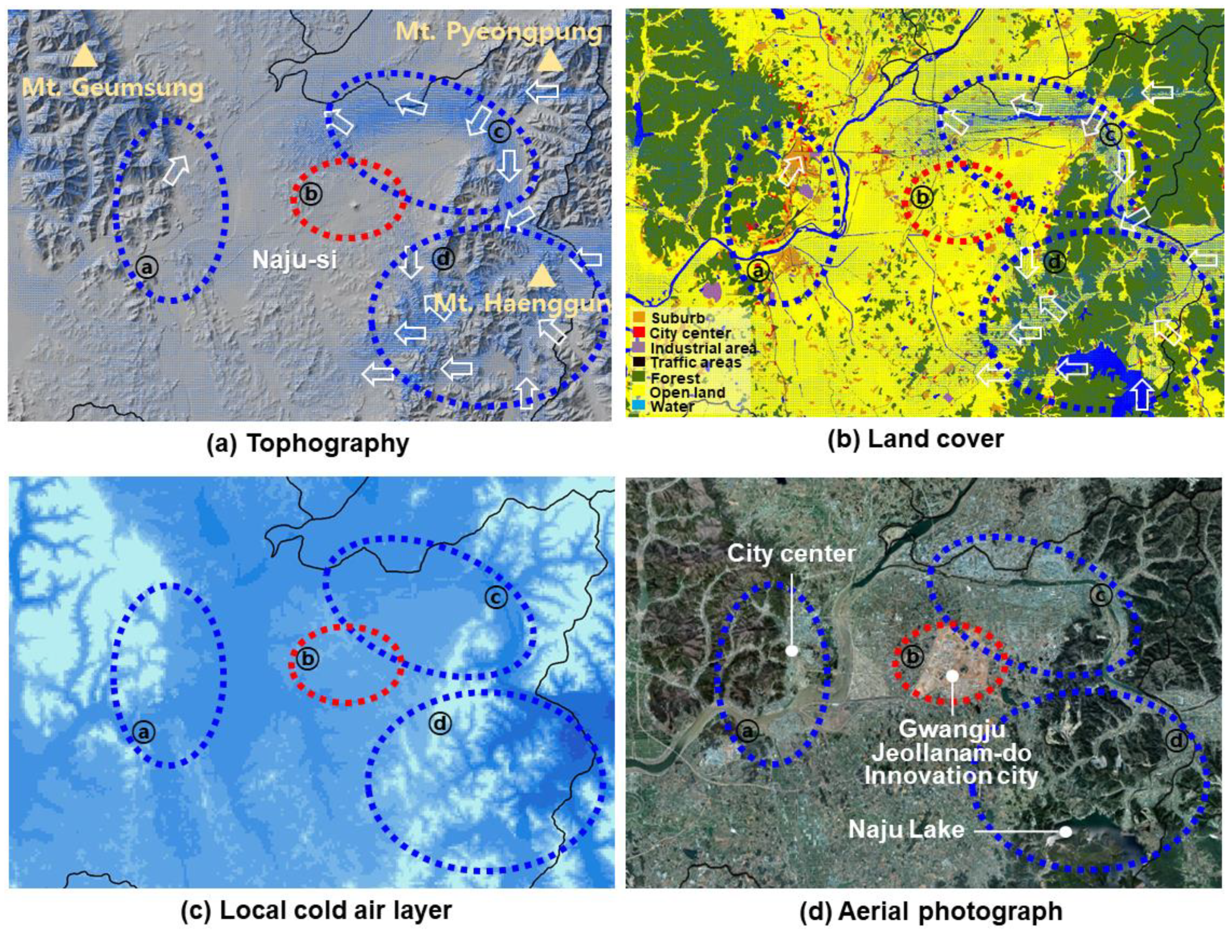
The cold airflow was generally weaker in Naju-si than in other areas (
Figure 12). However, the local cold air generated from nearby Mt. Geumsung was weak but affecting the downtown areas (ⓐ). The local cold air from Hwasun-gun, which was joined with the cold air generated by Mt. Pyeongpung, flowed strongly into the farmland (ⓒ), but the local cold air flow did not extend to the surrounding area. It is expected that the current cold air flows will worsen in areas that are land-covered farmland, but are currently being developed as an innovation city (ⓑ). In areas of Mt. Haenggun, the generated cold air was flowing down the valley, and it was developed more and more through Naju Lake (ⓓ).
4.2. Management Strategies in Urban Areas for Securing the Cooling Function of the Mountains
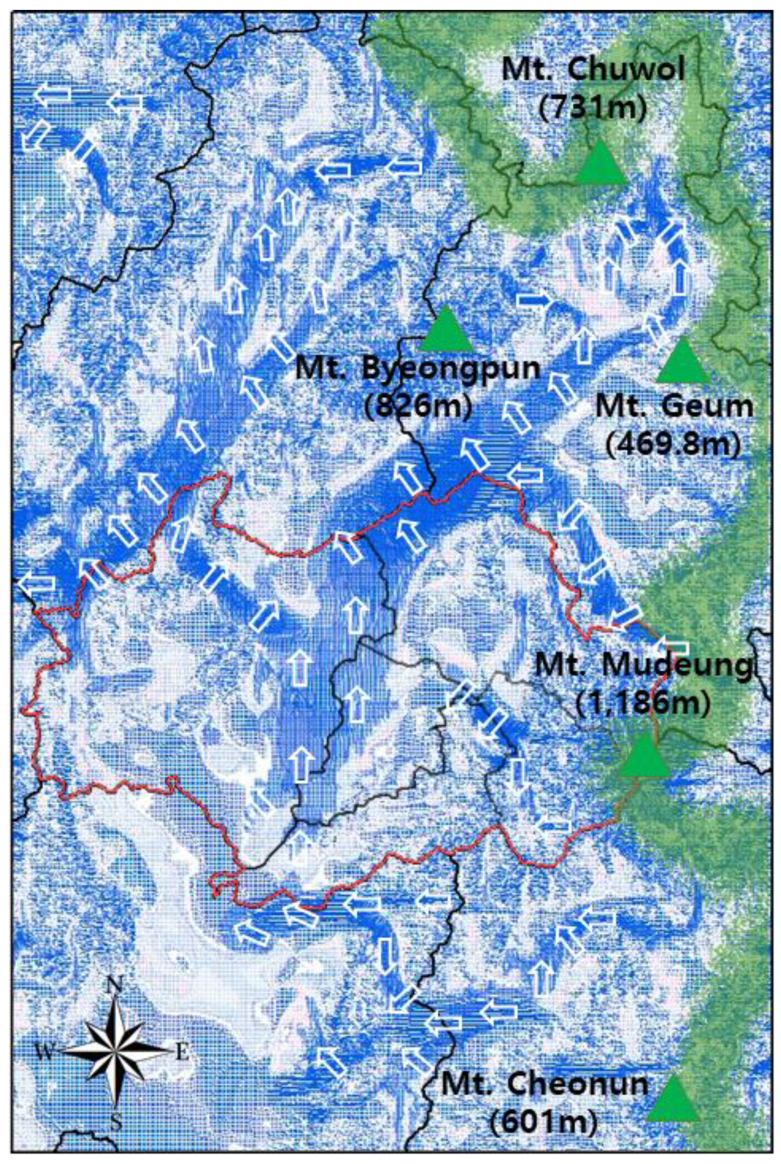
Based on the analysis of the local cold air characteristics, we suggest management strategies for securing the nighttime cooling function of the Honam Jeongmaek. We recommend designating the major mountains, including Mt. Chuwol, Mt. Mudeung, Mt. Cheonun, Mt. Byeongpung, and Mt. Geum, which were the source areas of the local cold air and influenced the cold airflow into adjacent areas, as the management area for securing the cooling function of mountains. Especially, Mt. Mudeung and Mt. Cheonun were producing the local cold airflow affecting the whole study area, including Gwangju Metropolitan, Hwasun-gun and Naju-si. Therefore, thorough preservation policies are required for these mountains from development that causes damages to mountainous terrain and topography.
Near administrative areas, the local cold air from Naju-si was passing smoothly along the Yeongsan River in Gwangju Metropolitan City. Thus, the Yeongsan River area was designated as the management area for maintaining the cooling function and the present flow should be maintained the present flow. Thus, the Yeongsan River area should be designated as the management area for maintaining the cooling function and the current flow should be maintained and extended to the industrial area in Gwangsan-gu. The local cold air from Mt. Mudeung partially influenced the densely developed areas in Dong-gu, but the airflow was generally not smooth in the rest of the densely developed areas in Gwangju Metropolitan City. Therefore, Jiwon-dong and Bangrim-dong areas in Dong-gu, which neighbors Mt. Mudueng, should be designated as the management areas for promoting the cooling function and plans for extending the local cold airflows are required to the areas. The Gwangju City Master Plan 2030 lists ‘establishing wind corridors’ and ‘wind corridor improvement plan’ as its major objectives [
34]. The 1 °C reduction project of Gwangju Metropolitan City (2017–2020) indicates the necessity for green space planning, such as planting roadside trees and building parks to provide wind corridors in each district. According to the 2012 statistics of urban parks in the seven metropolitan cities, Gwangju Metropolitan City’s park space falls behind the average rate (3.53%) with park space accounting for 1.86% of the city. The city’s per capita park space is 4.71 m
2, which is the lowest of all seven cities. Therefore, plans for extending to expand the local air flow that can be proposed in Gwangju Metropolitan City.
Jangseong-gun was the area with the smoothest cold airflow among the local administrative areas, so Mt. Yongjin and Mt. Pansadeung are required to maintain the current flow by designating the areas as the management area for maintaining the cooling function. However, some farmlands in Jiwon-myeon and Nam-myeon where the local cold air layer is stagnant, are expected to cause damage to frosty crops, so management is needed. It is recommended to consider areas with cold air stagnation when expanding the grass development, one of the key projects of Jangseong-gun. It is also important to take into consideration the nighttime cooling function of the surrounding mountains in future mountain development.
Damyang-gun, located in the Honam Jeongmaek, was directly affected by the local cold air. The local cold air from the Jeongmaek smoothly flowed into the city center through the agricultural areas. This condition will be favorable for controlling the heat environment of the city center. It is recommended to implement city-wide management and to develop policies that help maintain the current local cold airflow. As agriculture is the key industry of Damyang-gun, it is essential to maintain and manage the present agricultural areas. In some farmlands, the cold air congestion occurs, so it is necessary to reduce cold weather damage and to avoid further development.
The local cold air generated from Mt. Cheonun was developed along the farmland in Hawsun-gun and the Jiseok River and influenced the entire study site. Therefore, the farmland areas in Hawsun-gun should be designed as a management area for maintaining cooling function, and the current flows should be maintained. In the case of the agriculture industrial complex in Dong-myeon, the local cold air flows are very weak and cannot spread when air pollution occurs, which might affect people’s health. Thus, new agricultural and residential complexes should be avoided in this area. It is necessary to manage the Jiseok River so that the local cold air down the valley of Mt. Cheonun can flow into the residential area in Neungju-myeon.
In Naju-si, the local cold air generated by Hwasun-gun was influenced, but the flows were relatively weak compared to other regions. In particular, since the introduction of the local cold air from the innovation city is indispensable, the area of the innovation city should be designated as the management area for promoting the cooling function. For example, by expanding green spaces in the innovation city, the local cold air generated by Mt. Pyeongpung could flow into the innovation city.
5. Conclusions
This study aimed to establish management strategies for securing the nighttime cooling function of the Honam Jeongmaek in order to ensure a pleasant heat environment in the urban areas. For this purpose, we calculated the local cold airflow and altitude of local cold air layer generated during the nighttime in the mountains by administrative areas. Areas where local cold air flows were smooth and not smooth were analyzed. As the result, the local cold air expanded and traveled over wide flatlands, including agricultural areas and grasslands, as it moved along the valley areas, whereas the flow was stagnant in some other areas, due to local land development. Therefore, the average cold airflows were high in Dong-gu of Gwangju, Jangseong-gun and Damyang-gun, but they were low in Gwangsan-gu, Seo-gu Buk-gu, and Naju-si. Based on the results, we suggested the management plans to maximize the use of local cold air for each administrative areas. Most of all, Mt. Chuwol, Mt. Mudeung, Mt. Cheonun, Mt. Byeongpung and Mt. Geum were important sources for generating local cold and fresh air. Therefore, an effective preservation policy is required for the whole areas of the mountains. In the case of Gwangju Metropolitan City, we were unable to observe any local cold airflow in most of the densely developed areas. Therefore, measures customized to the areas are needed to support a sufficient development of the local cold air.
The most practical effect of improving the urban thermal environment is to transport the hot air effectively and circulate it into the cool air. This is more effective at night than during the daytime, so local cold air generation and flow at nighttime is very important. Therefore, the local cold air management strategies proposed in this study will contribute to mitigating the urban heat environment problem in the Honam Jeongmaek. In addition, this study could support the establishment of systematic management plans of the Honam Jeongmaek to preserve and enhance its cooling function and could be used as a basic data for the urban management plans.
The KALM applied in this study is a model that analyzes the characteristics of nighttime local cold air generated due to the geographic and land cover features of a certain area in an ideal weather condition. Thus, it is incapable of considering more diverse variables that may affect real weather events, such as local winds and forest types. In addition, both the energy conservation problems in the areas during the winter and all the people who were vulnerable to winter disease, living in areas near mountains were not considered in the management strategies for securing cooling function in this study.


