The Use of Dolostone in Historical Buildings of Coimbra (Central Portugal)
by
 , and
, and
Lidia Catarino
1,2,* ,
,
Roque Figueiredo
2,
Fernando Pedro Figueiredo
1,2,
Pedro Andrade
1,2 and
João Duarte
1 1
Geosciences Center, University of Coimbra, 3030-074 Coimbra, Portugal
2
Department of Earth Sciences, University of Coimbra, 3030-074 Coimbra, Portugal
*
Author to whom correspondence should be addressed.
Sustainability 2019, 11(15), 4158; https://doi.org/10.3390/su11154158
Submission received: 20 June 2019
/
Revised: 24 July 2019
/
Accepted: 30 July 2019
/
Published: 1 August 2019
(This article belongs to the Special Issue Natural Stone and Architectural Heritage)
Abstract
:In this paper, the importance of the dolostone (a carbonate sedimentary rock where the dominant carbonate mineral is dolomite) in monuments and urban buildings of the city of Coimbra, Portugal, is highlighted. Old quarries are not visible in the nucleus of the city, due to the sequential occupation by houses, and can only be identified by documentation (draws, contract letters and purchase orders). However, on the southern side of Mondego River (Santa Clara) some outcrops can be observed and were exploited until the mid-20th. It is presented a list of the old quarries and monuments made with this rock. The characterization of dolostones from the Coimbra Formation is also presented. It is made the connection between the local geology and the “identity” of Coimbra, putting in evidence the stone as a symbol that characterize the gilded aspect of the buildings. For restoration and rehabilitation works, a small number of blocks could be extracted from the Carvalhais quarry if were eventually necessary.
1. Introduction
Ever since the beginning of humanity, stone has always been an essential and emblematic element, constituting one of the supports for the development of society, including its connection to the discovery and control of fire by Homo Erectus, as well as the first utensils used for hunting and gathering food. With the Neolithic Revolution humankind stopped the hunter-gatherer lifestyle adopting sedentary habits, giving rise to great technological advances, one of the most important aspects being the establishment of and in communities. Over time, this new form of organization gave rise to the concept of state, and to the development of large cities, which would become major commercial centers [1]. With this evolutionary explosion, the demand for geological resources became higher, giving rise to the increase of stone exploitation.
Due to the characteristics of different types of rock, and their advantage for construction, stone has always been the most required and used material—from the construction of communication routes to the ostentatious monuments that have been developed over the centuries. However, most of the times, quarries were established in a local exploitation perspective, since transporting stone blocks over hundreds or thousands of kilometers was very difficult to achieve [2]. From this perspective, it is possible to create a link between interconnected local geology and heritage with the identity of a region.
The city of Coimbra, Portugal, is provided with several buildings in the historic center and some of them going back to the Roman occupation made with dolostone (a carbonate sedimentary rock where the dominant carbonate mineral is dolomite) and, sometimes, with dolomitic-limestone rocks [2]. Over the centuries these buildings became monuments and were the object of masonry conservation or modifications. However, from an architectural point of view, most of them preserve some or all the characteristics that marked the periods in which they were built [3].
Stone has always been used in several different ways in construction. One of the biggest uses was stonework to made ashlars when the buildings presented stone facades. However, the carbonated rocks were also calcined to produce lime, used in mortar or renders. In Coimbra, lime was of dolomitic composition, due to the presence of dolomite in the stone used for this purpose. In current residential buildings, stone blocks with smaller dimensions were used in masonry, bonded by mortar and covered with one or two layers of render and generally painted as well.
In fact, stone can be one of the characteristic symbols of a region’s singularity, in terms of color and features, but also in terms of the urban landscape.
Coimbra is internationally known as a city where the university presents a great preponderance after the 13th century and, since 2013, integrate the UNESCO World Heritage List with the designation “University of Coimbra—Alta and Sofia”.
A tourist will generally observe the monuments from an architectural/emblematic perspective, often forgetting the history behind each block that constitutes the monuments or decorative pieces. This work highlights the use of dolostone and its influence on the building heritage in the municipality of Coimbra. The main objective is to understand the linkage of local geology with the most emblematic monuments that characterize the historical patrimony of the city and its proximity with old quarries. It is also important for the identification of locals with the exploitation potential of blocks to be used in rehabilitation and restoration.
2. Study Area
2.1. Geological Overview
The municipality of Coimbra is situated in the Central region of Portugal, belonging to the Baixo Mondego sub-region, presenting an area of 319.4 km2. The old city is located in a hill with approximately 25 ha and 99 m higher altitude.
Coimbra municipality is located in the contact between two major lithological groups: The Hesperic Massif with Pre-Cambrian and Paleozoic Formations, and the Meso-Cenozoic western border.
The Hesperic Massif, also denominated as Iberian Massif, is mainly composed by schist and hercinic granites [4]. In Coimbra region, the schists are dominant and impose a significant contrast in the morphology presenting higher altitudes than the sedimentary rocks.
The Meso-Cenozoic western border belongs to the Lusitanian Basin [5], which is located on the Iberian Western Margin and is a non-volcanic passive margin rift [6]. The Basin occupies an area of 20,000 km2, with a length of 200 km in the NNW-SSE direction and 100 km of extension in the perpendicular direction, corresponding to 2/3 of the continental emerged area [7].
Since the 19th century, the region of Coimbra aroused the curiosity of national and foreign geologists. Over time, the records obtained from the investigations correspond to several designations for the various lithostratigraphic units.
In this work, the main geological object corresponds to the Lower Jurassic dolomitic-limestone succession of Lusitanian Basin outcropping in the old urban area of Coimbra where most of the monuments can be found, commonly named with the informal designation of “Coimbra Group”.
In the most recent lithostratigraphic definition of the Lower Jurassic dolomitic-limestone succession from Lusitanian Basin [8], the previous informal Coimbra Group designation [7,9,10] was abandoned and replaced by the joint of two formal units—the essentially dolomitic Coimbra Formation (Fm.), at the base, and the more calcareous and marly-limestone (when not dolomitized) S. Miguel Fm., at the top.
As previously mentioned, the “Coimbra Group” was always subdivided into two diachronic units. However, according to Reference [8] with the normative imposed by the International Stratigraphic Guide, the transition between both is now placed at a different level when compared to previous publications.
This dolomitic-limestone succession, cropping out in the Coimbra-Penela region, ranging in age from the Early Sinemurian to the Early Pliensbachian ([8]; and references herein), is fit between the essentially pelitic units of the Pereiros Formation (Hetangian) and the marly-limestone units of the Vale das Fontes Formation (Figure 1). It is geographically located between the North of Coimbra and Penela, and occupies an area of 210 km2 with a combined thickness of ca. 110 m, presenting a W-NW orientation dip, with an irregular relief and tops around 300 m [8].
The Coimbra Fm. is dated from the Early to Late Sinemurian, and is on apparent continuity with the Pereiros Fm. [11]. The upper limit of this unit corresponds to the passage between the layers of microcrystalline limestone or dolomitic limestone for the more marly-limestone layers above, defined by a discontinuity surface [8]. From bottom to top, it is possible to identify layers of massive orange dolomites interspersed with gray to black laminate pelitic rocks, levels of marly dolomites and low fossiliferous masses presenting weak bioturbation and impure massive dolomites with a greyish color to the top. Following these are strata of dolomitic limestone and micritic dolostone with an orange-yellowish color, sometimes fossiliferous and bioturbated.
In the Coimbra Fm., it is possible to recognize spathic calcite veins linked to dissolution phenomena with successive (or contemporaneous) recrystallization and reduced content of fossils [8].
The S. Miguel Fm. is dated from the Upper Sinemurian to the base of the Pliensbachian, presenting a thickness of 40 ± 10 m, with more regular strata and apparent coherence when compared with the Coimbra Formation. The upper limit between the S. Miguel Fm. and the Vale das Fontes Fm. represents the main discontinuity surface of the lithostratigraphic succession. From bottom to top, it is composed of gray and whitish dolomitic limestone, sometimes fossiliferous and bioturbated, interspersed by gray or yellowish marls with little thickness (Figure 1). Finally, are identified limestones gray to orange, followed by biodetritic/fossiliferous marls and marly-limestones with a very small thickness [8].
2.2. Historical Urban Development
The city’s origin dates back to the Roman occupation, during Emperor Augustus domain (27 BC – AD 14). The civitas Aeminium was organized in an orthogonal configuration, in which the cardo maximus (N-S) and the decumanus maximus (E-W) intersected in the forum, which is a political, religious and mercantile center of the city [12]. One of the biggest roman remains is a cryptoportic, in the present day integrating the Machado de Castro Museum. After the Roman Empire fell off in the fifth century, Aeminium became part of the Suevian domain and with the fall of these in the sixth century, of the Visigoth domain. With the weakening of the Visigothic kingdom and coinciding with the Muslim campaigns that ran between 711 and 715, the city fell into Muslim rule in 714 and was later conquered by Christians in 1064 [13].
After the formation of the kingdom of Portugal (1139) and until 1260, the city of Coimbra was the capital of the territory. The construction of new churches and rebuilding of the old ones is related to city development. The number of constructions dated from 11–12th century is larger than the precedent and subsequent periods. At the time, the city had a military function but also corresponded to a dynamic commercial town connected with two important trade routes. Therefore, the twelfth century is considered as the golden period of the city’s history [13].
In the Middle Ages the existence of a defensive wall was fundamental for the preservation of the people and the city. The Coimbra city walls no longer exist, but they are represented in pictures, and some of the medieval defensive towers are still preserved.
The construction of the Old Cathedral began in the early 1160s, and was completed in the 13th century. It was built in the same place as an existing mosque of the 9th century, due to the privileged location. The main facade presents a defensive structure, organized in a tripartite form, with central body advanced and incorporating military features, such as two towers. In the 16th century the construction of the Porta Especiosa by the architect João de Ruão using Ançã Stone [14,15], contributing to the aesthetics of the building. Despite some remodeling, its interior presents the same characteristics of its original configuration [16].
The Santa Cruz Monastery is one of the biggest constructions of the golden period. It was founded in 1131 and completed in 1228. Initially, the church was composed by one nave, reinforced by two lateral naves structured in chapels connected to the central nave and by a tower in the facade. The Santa Cruz Monastery underwent several rebuilding and modifications elaborated throughout the centuries, particularly those of the first half of the 16th century. Between 1522 and 1526, it was included the portal in Ançã Stone, created by Diogo Castilho and produced by Nicolau de Chantereine, and the cloister [17].
On the southern side of the Mondego River, Santa Clara-a-Velha Monastery started being built in 1286. The original building was supervised by the architect Domingos Domingues. The church is constituted by three naves of seven sections, without a transept and with a tripartite chapel of the polygonal apse. Floods caused by the Mondego River over the years led to several problems. Despite some restructuring, life in the monastery became unsustainable which led to its abandonment in 1677, and the nuns were installed in the Santa Clara-a-Nova Monastery, located at a higher altitude on the same side of the river [18].
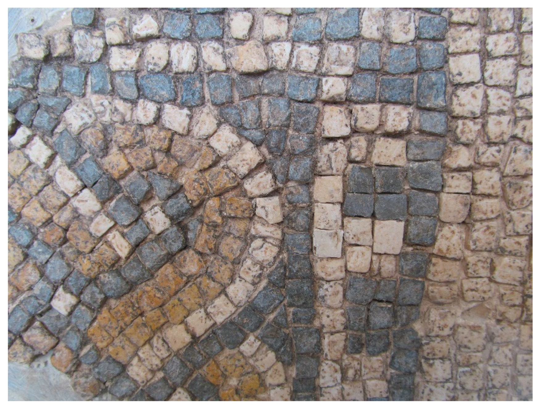
The Royal Palace, with the original construction as the Alcáçova (fortified palace where the governor of the city lived during the period of Muslim rule), was built under the orders of Almançor in the late 10th century [19]. During the 20th century, archaeological excavations were carried out, which identified roman structures and mosaics stressing the importance of the local (Figure 2). After the conquest of the city, the Royal Palace became the residence of Afonso Henriques (the first king of Portugal), and today is the main building of the University of Coimbra, including the S. Miguel chapel and the opulently decorated Baroque Library (1716–23) [20].
With the permanent settlement of the university in Coimbra in 1537 by order of João III, the urban space registered significant growth. The construction of many colleges to host students that want to become enlightened, was one of the significant developments for the city. One example is the S. Bento College, located near the S. Sebastião Aqueduct, which was rebuilt in the same epoch, but maintained the same layout of the previous one, that dates back to the Roman period [13]. The Botanic Garden was constructed in a nearby area of the S. Bento College for educational purposes. According to its importance, the university was nominated to belong to the UNESCO World Heritage List in 2013 with the designation “University of Coimbra—Alta and Sofia”.
The construction of the Santa Clara-a-Nova Monastery began in 1649 and was completed in the 18th century with the conclusion of the cloister, gateway and aqueduct. The plant was designed by Frei João Turriano and supervised by Mateus do Couto. By 1696 occurs the consecration of the church with the works partially completed, but part of the building was already occupied. For the construction of this monument, a simplified plant and straight lines were used in accordance with the Mannerist movement. The rectangular nave is divided into five sections separated by framing Doric pilasters and altarpieces of golden carvings, designed by Mateus do Couto and built by António Gomes and Domingos Nunes in 1692 [21].
In this short description, it is only mentioned few of the principal buildings referred below, due to its relevance in relation with the quarries.
3. Methodology
The methodology used to perform this work is expressed in the flowchart of Figure 3. The identification of monuments was made by bibliographic research and fieldtrip in order to verify the existence of dolostone as stonework in facades or other constructive elements. The quarries identification of the non-visible was made using references, consulting aerial photography and Google Earth Pro application to verify its existence, according to the actual morphology of the surface followed by field survey. Alongside the field research of the abandoned quarries, the distribution of the lithological types was identified, and some characterization assays were carried out—allowing the future to complement the assessment of its potential to be used in rehabilitation and restoration works. The strength, deformability and durability of the selected rocks can be determinate using several tests. Density and porosity can be obtained following EN 1936 (1999) [22] or ISRM (1981, 2007) [23,24]. Sound velocity, Schmidt rebound hardness, slake durability tests can be performed in accordance with ISRM (1981, 2007) [23,24], uniaxial compressive strength and deformability can be carried out in line with ISRM (1981, 1999) [23,25], point load strength can be obtained following ISRM (1985) [26].
This procedure, in conjunction with the use of other characterization methods, will be important tools to select areas with similar rock types, to those used in the building of monuments, conservation, and restoration.
4. Results
The monuments mentioned above corresponds to some of the more relevant in the city of Coimbra. However, taking in consideration the presence of dolostone in monuments and urban buildings, were identified a total of 27 monuments of particular importance, which were constructed between the seventh and eighteenth centuries, proving the reputation of the dolostone during several centuries in various urban buildings and in other useful or defensive structures on the city and surrounds (Figure 4, Figure 5 and Figure 6 and Table 1).
4.1. Location of Ancient Quarries
Following the logic that the ancestors take advantage of the local geology, due to logistical and economic aspects, research was carried out in order to identify old quarries in Coimbra. Until the middle of the 20th century, some small quarries were still in progress, but nowadays no dolostone quarry is active in the surrounding area of the city. The red sandstone was also quarried and permitted to obtain blocks used in masonry. One of the quarries was exploited in the city until 1895 when the area was transformed into an arboreal park [27].
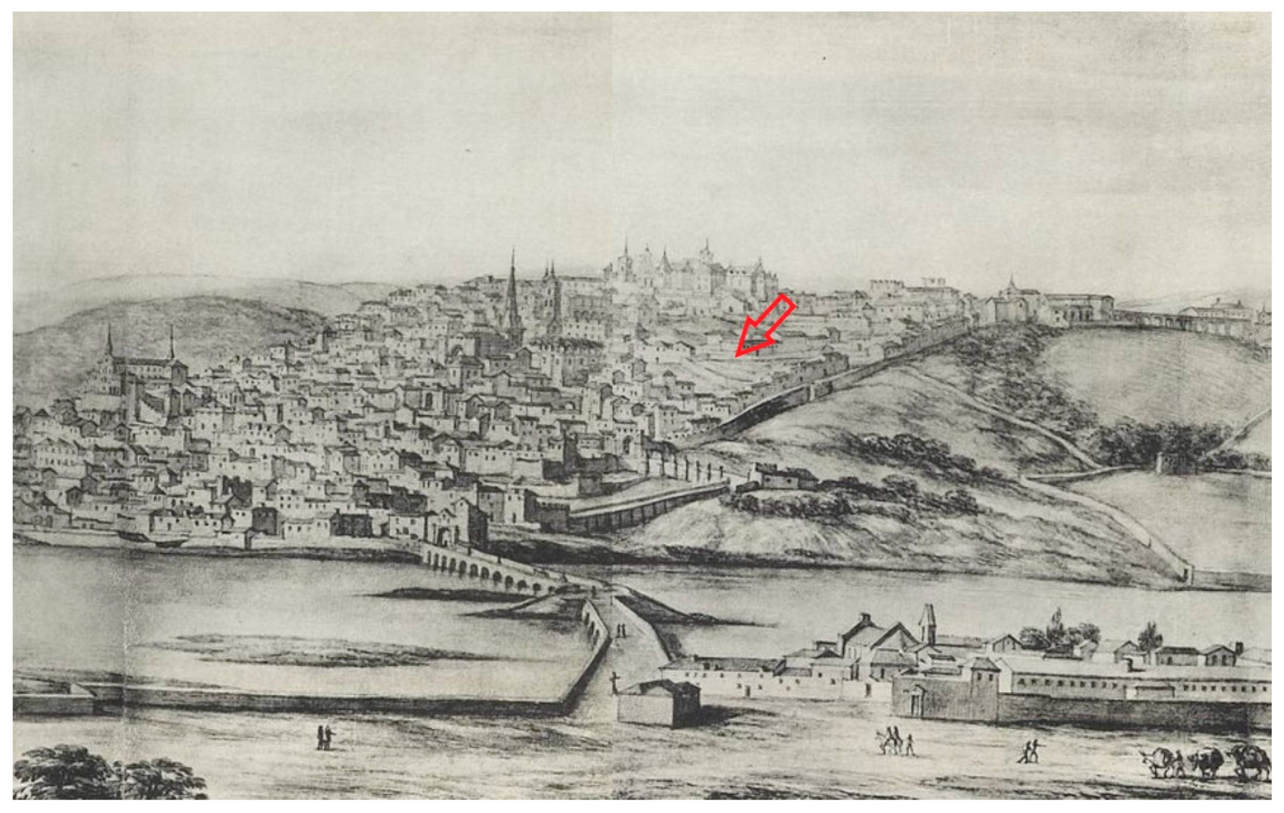
Related to this subject and using the local toponymy it can be identified very close to the university (Royal Palace) a place that preserve the word quarry (in Portuguese language: Pedreira) in a church (Santo António da Pedreira church), and an alley in the corner of the same building (Figure 7). This quarry was active from 13th century to 1773 [15,28].
Alarcão [2,28] based on draws, contract letters and purchase orders mentioned the presence of other quarries located inside the city walls, with the notice that thousands of cubic meters of stone were needed for the construction of several major buildings. Some of the quarries were located very close to the main buildings of the city (Figure 8 and Table 2):
- -
- -
- The Montarroio quarry was the property of Santa Cruz Monastery since the 12th century [28];
- -
- The S. Sebastião quarry near the castle, in the place where after was constructed the College of Arts and very close to the aqueduct of S. Sebastião (14th century) [28];
- -
- -
- S. Cristovão quarry, where today, the Sousa Bastos Theater is situated, close to Belcouce Tower inside the city wall [32].
Outside the city walls other references mentioned the Conchada and Monte Formoso quarries, probably identified in outcrops still observed at the end of the 20th century [15].
On the left bank of the Mondego River, was used dolostone in both Santa Clara monasteries. In that area are observed six quarries, some of them used for lime production until the mid-20th century (Figure 8). In 1889, a book organized by the Portuguese Industrial Association, about the reality of the mines and quarries exploitation at that time, identified in the urban perimeter of Coimbra the quarry of Bordalo (Santa Clara) and the extracted stone was used to the production of lime, masonry and stonework. It is highlighted the resistance to weathering and the “agreeable” aspect of the stone refereeing that was used in two bridges near the city. The other quarry identified is the one the Montarroio used for masonry and lime production, but with less importance at that time [33].
4.2. Dolostone Characteristics
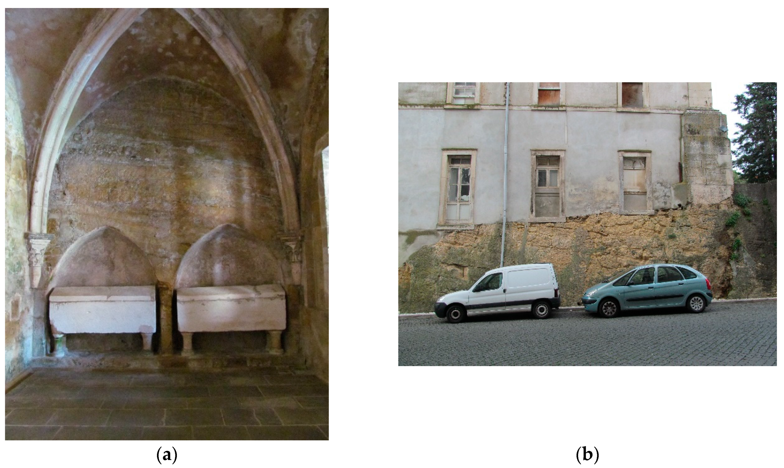
The dolostone quarried in the layers belonging to the Coimbra Fm. is characterized by heterogeneous properties, which provides a differential degradation by its surface [34] and is much more difficult to work than the Ançã Stone, which is often used in the city of Coimbra for decorative pieces, due to the white color and the easy cut. In monuments dating back to the 12th and 13th centuries, dolostone was used as stonework on the exterior walls and also in the interior as vaults and columns. For current buildings, dolostone was adopted in masonry for structural purposes [35].
The chemical composition of the dolostone and calcareous-dolomite of Coimbra Formation obtain from ashlars used in the Old Cathedral presents a content of CaO of 23 to 31%, MgO from 16 to 21%, Fe2O3 vary from 0.8 to 4% and residual quantities of other oxides [15]. Analyses of dolostone from outcrops far from the nucleus of the city presents a content in MgO lower than 18%, frequently between 9.5 and 15% [36]. In addition, the high content in Fe2O3 gives a yellowish color to the stone [15,36].
With different objectives, several drilling holes were made in the nucleus of the old town close to the location of S. Sebastião and Largo da Feira quarries. Physical and mechanical characterization aiming to define strength, deformability and durability (Table 3), was carried out using 85 samples [37]. Dolostone with different degrees of weathering (W1, W2 and W3) was studied and classified according to its results.
Where Is(50) corresponds to point load strength index corrected to a diameter of 50 mm; UCS to uniaxial compressive strength; R to Schmidt rebound hardness; Ed to Dynamic elastic moduli; Es to static elastic moduli; Id2 to slake-durability index of the second cycle; Vp and Vs to velocity of the longitudinal and transversal waves ultrasonic velocity of propagation, respectively.
Tests performed with samples obtained in existing old quarries in Santa Clara area present values of density and porosity similar to the ones identified as W2 and W3 [38].
Dolostone weathering corresponds to powdering and flacking and presents differential erosion associated with the heterogeneities and the presence of recrystallized calcite filling fractures, more resistant than the dolomite [15,34]. The areas of lower quality present degrees of degradation that are more pronounced.
Seco et al. [39] carried out data in outcrops of the Coimbra Formation from natural gamma-ray spectrometry measurements (total counts, K, Th and U contents). These concentrations can be used for the indirect evaluation of parameters, such as the clay minerals content, grain size variation, porosity and content of total organic carbon, among others. They observed a reduction of the gamma-ray flux from the base to the top. The dolomitic limestone and dolostone (Coimbra Fm.) varying in the base between 140 and 247 cps, in the intermediate part between 61 and 114 cps and at the top between 101 and 106 cps. Gamma-ray flux varies between 107 and 168 cps at the top of the succession (S. Miguel Fm.). In terms of mean values of the radiogenic elements, no significant differences were observed and present values of 0.4% K, 1.3 ppm U and 1.6 ppm Th.
5. Discussion and Conclusions
Alarcão [2,28] highlighted the position of the quarries located in Coimbra in relation to the buildings saying they were inside the city walls and in the highest point in the city close, therefore, to the buildings to be constructed. By observing the geological map and the position of the old quarries inside the wall, it is easy to understand that most of the monuments are located inside the area where the geological units of Coimbra Formation are present (Figure 4, Figure 6 and Figure 8). So the quarries located in the nucleus of the city of Coimbra provided the necessary stone for the monuments and urban buildings located in this area, while the quarries located in Santa Clara provided the needs for the buildings in the other side of the river. Only the quarries located in Santa Clara are still observed (Table 2). Those located in the nucleus of the city, admitted by references in several types of documentation and bibliography, can only be assumed in areas not occupied by houses in illustrations of the time (Figure 7).
Two major architectural/urban phases are identified in the city of Coimbra: The period comprising the 12th and 13th centuries and later between the 16th and 18th centuries. Between the end of the 13th and 15th centuries, there is no evidence of the construction of monuments. This time period corresponds to the consolidation of the city, but also may be related to the period of the Fernandine wars (14th century), as well as to the beginning of the overseas campaigns (15th century).
Dolostone was used in the stonework on the facades and structural pieces in the interior, such as vaults and columns, in the monuments constructed during the 12th and 13th centuries. In this period, it was used with some frequency in decorative pieces, particularly in contrast to white painted walls giving rise to a gilded aspect (Figure 10). Contrast was also created when, centuries later, the Ançã Stone was used due to its very noticeable white colour. In some of these monuments, it is still possible to identify the geological registry of the outcrops in its interior, as is the example of the Old Cathedral (Figure 9a).
The dolostone use in the monuments, built between the 16th and 18th centuries, is only visible in the quoins and pilasters. In these buildings, dolostone was also applied in masonry on the outer walls, and lintel around the windows and doors. The gilded aspect also presents a contrast with the surrounding white walls.
The dolostone belonging to the Coimbra Fm. were studied throughout the years from a lithostatigraphic point of view, but only a few publications exist related to the properties as a building material [15,34,37]. This was probably due to the inexistence of active quarries after the middle 20th century when the investigation of that matter presents a great increment. The area of the last quarries of Bordalo and Montarroio, used for blocks and lime production until that time, were also abandoned, due to the building boom. Moreover, the dolomitic lime was replaced by calcite lime and cement.
The velocity of the longitudinal waves ultrasonic velocity of propagation for the W1 and W2 dolostones was considered as medium and low for the W3 dolostones. According to the uniaxial compressive strength and the point load strength index corrected to a diameter of 50 mm values, the rock strength was classified as high for the W1 group, medium for W2 and low for W3. The porosity values of the W1, W2 and W3 dolostones presented a medium, high and very high porosity, respectively. So, it is accepted that the dolostone present mechanical properties that allow over the centuries its utilization in construction, as can be observed.
As presented in Table 2, all the buildings present across the centuries several modifications, reorganizations and changes of use. At the end of 19th century, the Old Cathedral was in conservation/restoration/rehabilitation works for ten years [14]. The Colleges that belong to the University campus, the Baroque Library, S. Miguel Chapel, Botanic Garden and others had also restoration and rehabilitation works [40].
In preservation and rehabilitation of old buildings the use of new stones is often needed to replace the degraded ones, which do not present safe conditions. The exploitation of dolostone around the city of Coimbra has been abandoned for more than twenty years. This conducted to the use of similar stones from other parts of the country when the replacement is need.
An example of this is the S. Francisco Convent. It corresponds to a large compound of different built bodies, with two to three floors each, organized around a cloister. Built in the 17th century, the structure was occupied by the Franciscans until 1843, after which, and until the mid-20th century, several factories were installed, such as a wool factory from 1888 until 1980, with considerable impact on the main structure [41]. The rock used in the facades and pavement of the rehabilitation works (2010–2016) was a dolomitic breccia that came from Serra de Aires and Candeeiros, near Moleana, Porto de Mós.
Considering that most of the old buildings of Coimbra are included in the UNESCO World Heritage List, it is important to preserve the heritage and the materiality of the city. Taking into account the existence of several outcrops in the Santa Clara region that corresponds to old quarries, some of them exploited up to the last twenty years for the production of aggregates; it is possible to use, with prudence and vigilance from the authorities, stone from those quarries. The one presented in Figure 11, corresponds to the indicated as d (yellow dot) on Figure 8, due to the easy access to trucks and to the occurrence of stone with good quality has great relevance for this use. The other quarries signalized in Figure 6 also present proper stone, but due to the location near houses or monastery (Santa Clara-a-Nova Monastery) and with difficult accessibility, are less recommended for this use.
The “identity” of the city is dependent on its geological location, and the stone corresponds to a symbol that characterizes its gilded aspect. This was highlighted by Vasconcelos in 1930 [14] in relation to the apse of the chapel in Old Cathedral, and can be extended to the chromatic characteristics of the stone buildings and the city.
Author Contributions
All authors contributed equally to this paper and approved the final manuscript. Conceptualization and methodology, F.P.F., J.D., P.A. and L.C.; field work, J.D., F.P.F., R.F. and L.C.; laboratory tests, investigation and validation data, P.A., L.C. and R.F. All authors were involved for the writing and editing of the manuscript.
Funding
This research received no external funding.
Acknowledgments
The financial support of FCT-MEC through national funds and, when applicable, co-financed by FEDER in the ambit of the partnership PT2020, through the research project UID/Multi/00073/2013 of the Geosciences Center is acknowledged.
Conflicts of Interest
The authors declare no conflict of interest.
References
- Childe, G. A Evolução Cultural do Homem; Zahar Editores: Rio de Janeiro, Brazil, 1975. [Google Scholar]
- Alarcão, J. Pedreiras antigas de Coimbra. In A Terra. Conflitos e Ordem. Livro de Homenagem ao Professor Ferreira Soares; Callapez, P., Rocha, R., Marques, J., Cunha, L., Dinis, P., Eds.; MMGUC: Coimbra, Portugal, 2008; pp. 71–73. [Google Scholar]
- Alarcão, J. A Evolução Urbanística de Coimbra: Das Origens a 1940; Cadernos de Geografia: Coimbra, Portugal, 1999; pp. 1–10. [Google Scholar] [CrossRef]
- Teixeira, C. Geologia de Portugal, Pré-Câmbrico e Paleozoico; Fundação Calouste Gulbenkian: Lisboa, Portugal, 1981; Volume I, p. 629. [Google Scholar]
- Ribeiro, A.; Silva, J.B.; Cabral, J.; Dias, R.; Fonseca, P.; Kullberg, M.C.; Terrinha, P.; Kullberg, J.C. Tectonics of the Lusitanian Basin; Final Report, Proj. MILUPOBAS, Contract n° JOU-CT94-0348, ICTE/GG/GeoFCUL; Universidade de Lisboa: Lisboa, Portugal, 1996; p. 126. [Google Scholar]
- Alves, T.M.; Moita, C.; Sandnes, F.; Cunha, T.; Monteiro, J.H.; Pinheiro, L.M. Mesozoic–Cenozoic evolution of North Atlantic continental-slope basins: The Peniche basin, western Iberian margin. AAPG Bull. 2006, 90, 31–60. [Google Scholar] [CrossRef]
- Kullberg, J.C.; Rocha, R.B.; Soares, A.F.; Rey, J.; Terrinha, P.; Azerêdo, A.C.; Callapez, P.; Duarte, L.V.; Kullberg, M.C.; Martins, L.; et al. A Bacia Lusitaniana: Estratigrafia, Paleogeografia e Tectónica. In Geologia de Portugal; Dias, R., Araújo, A., Terrrinha, P., Kullberg, J.C., Eds.; Escola Editora: Vila Franca de Xira, Portugal, 2013; Volume II, pp. 195–347. [Google Scholar]
- Dimuccio, L.A.; Duarte, L.V.; Cunha, L. Definição litostratigráfica da sucessão calco-dolomítica do Jurássico Inferior da região de Coimbra-Penela (Bacia Lusitânica). Comun. Geológicas 2016, 103, 77–96. [Google Scholar]
- Dimuccio, L.A. A Carsificação nas Colinas Dolomíticas a sul de Coimbra (Portugal Centro-Ocidental). Fácies Deposicionais e Controlos Estratigráficos do (Paleo)Carso no Grupo de Coimbra (Jurássico Inferior). Ph.D. Thesis, FCT University of Coimbra, Coimbra, Portugal, 2014; p. 436. [Google Scholar]
- Soares, A.F.; Marques, J.F.; Sequeira, A.D. Carta Geológica de Portugal, na Escala 1/50 000. Notícia explicativa da Folha 19-D, Coimbra-Lousã; INETI: Lisboa, Portugal, 2007; pp. 1–71. [Google Scholar]
- Soares, A.F.; Kullberg, J.C.; Marques, J.F.; Rocha, R.B.; Callapez, P. Tectono sedimentary model for the evolution of the Silves Group (Triassic, Lusitanian basin, Portugal). Bull. Soc. Géol. Fr. 2012, 183, 203–216. [Google Scholar] [CrossRef]
- Alarcão, J. O Domínio Romano em Portugal, 3rd ed.; Publicações Europa-América: Coimbra, Portugal, 1995; p. 244. [Google Scholar]
- Mattoso, J. História de Portugal. Antes de Portugal; Editorial Estampa: Lisbon, Portugal, 1997; Volume I–III, p. 452. [Google Scholar]
- Vasconcelos, A. A Sé-Velha de Coimbra. Apontamentos para a sua História; Imprensa da Universidade de Coimbra: Coimbra, Portugal, 1930; Volume I. [Google Scholar]
- Quinta-Ferreira, M.; Soares, A.F.; Delgado Rodrigues, J.; Monteiro, B. Carbonate rocks from Sé Velha Cathedral, Coimbra, Portugal. In Proceedings of the 7th International Congress on Deterioration and Conservation of Stone, Coimbra, Portugal, 15–18 June 1992; pp. 947–956. [Google Scholar]
- SIPA. Sé Velha de Coimbra. Available online: http://www.monumentos.gov.pt/Site/APP_PagesUser/SIPA.aspx?id=2673 (accessed on 15 May 2019).
- SIPA. Mosteiro de Santa Cruz. Available online: http://www.monumentos.gov.pt/Site/APP_PagesUser/SIPA.aspx?id=4234 (accessed on 15 May 2019).
- SIPA. Mosteiro de Santa Clara-a-Velha. Available online: http://www.monumentos.gov.pt/Site/APP_PagesUser/SIPA.aspx?id=2807 (accessed on 15 May 2019).
- Catarino, H.; Filipe, S. “Madinat Qulumbriya: Arqueologia Numa Cidade de Fronteira”, Al-Ândalus Espaço de Mudança. Balanço de 25 anos de História e Arqueologia Medievais, Seminário de Homenagem a Juan Zozaya Stabel-Hansen (Mértola 2005); Campo Arqueológico de Mértola: Mertola, Portugal, 2006; pp. 73–85. [Google Scholar]
- Filipe, S. Arqueologia urbana em Coimbra: Um testemunho na Reitoria da Universidade. Conimbriga Rev. Arqueol. 2015, 45, 337–357. [Google Scholar] [CrossRef]
- SIPA. Mosteiro de Santa Clara-a-Nova. Available online: http://www.monumentos.gov.pt/Site/APP_PagesUser/SIPA.aspx?id=2678 (accessed on 15 June 2019).
- EN 1936. Natural Stones Test Methods—Determination of Real Density and Apparent Density, and of Total and Open Porosity; European Committee for Standardization (CEN): Brussels, Belgium, 1999. [Google Scholar]
- ISRM. Rock Characterization Testing & Monitoring. In ISRM Suggested Methods; Brown, E.T., Ed.; Published for the Commision on Testing Methods; Pergamon Press: Oxford, UK, 1981; p. 211. [Google Scholar]
- ISRM. The Complete ISRM Suggested Methods for Rock Characterization, Testing and Monitoring: 1974–2006; Ulusay, R., Hudson, J.A., Eds.; ISRM: Ankara, Turkey, 2007; p. 628. [Google Scholar]
- ISRM. ISRM suggested method for the complete stress-strain curve for intact rock in uniaxial compression. Int. J. Rock Mech. Min. Sci. 1999, 36, 279–289. [Google Scholar]
- ISRM. ISRM suggested Method for Determining Point Load Strength. Int. J. Rock Mech. Min. Sci. Geomech. 1985, 22, 51–60. [Google Scholar] [CrossRef]
- Rosmaninho, N. O Poder da arte: O Estado Novo e a Cidade Universitária de Coimbra; Coimbra University Press: Coimbra, Portugal, 2006; p. 171. [Google Scholar]
- Alarcão, J. Coimbra: A Montagem do Cenário Urbano; Imprensa da Universidade de Coimbra: Coimbra, Portugal, 2008; p. 308. [Google Scholar] [CrossRef]
- SIPA. Available online: http://www.monumentos.gov.pt (accessed on 5 June 2019).
- Calmeiro, M.R. Apropriação e conversão do Mosteiro de Santa Cruz. Ensejo e pragmatismo na construção da cidade de Coimbra. Monastic architecture and the city. In Cescontesto, Debates; Marado, C.A., Ed.; CES: Coimbra, Portugal, 2014; Volume 6, pp. 227–240. Available online: https://www.ces.uc.pt/publicacoes/cescontexto/index.php?id=10019 (accessed on 12 July 2019).
- Sanchez Rivero, A.; Sanchez Rivero, A.M. Viaje de Cosme de Médicis por España y Portugal (1668–1669). Laminas; Junta para Ampliacion de Estudios e Investigaciones Científicos: Madrid, Spain, 1933; Available online: http://purl.pt/12926 (accessed on 10 June 2019).
- Anjinho, I.M. Fortificação de Coimbra das Origens à Modernidade; CEAACP, Universidade de Coimbra: Coimbra, Portugal, 2016; Volume 3, Available online: https://eg.uc.pt/handle/10316/31013 (accessed on 15 June 2019).
- Monteiro, S.; Barata, J.A. Catalogo Descriptivo da Secção de Minas; Imprensa Nacional: Lisboa, Portugal, 1889; p. 373. [Google Scholar]
- Delgado-Rodrigues, J. As pedras de Coimbra. Aspectos relativos à sua degradação e conservação. In Proceedings of the Conference International “A imagem dos centros históricos—Bases para a sua salvaguarda”, Coimbra, Portugal, 21–23 September 2005; Available online: https://www.academia.edu/34029616/ (accessed on 8 May 2019).
- Vicente, R.; Silva, J.A.R.M.; Harum, H. Caracterização das Alvenarias dos Edifícios da Baixa de Coimbra. As Suas Anomalias Típicas. In Proceedings of the PATORREB 2006 2.º Encontro Nacional sobre Patologia e Reabilitação de Edifícios, Porto, Portugal, 20–21 March 2006; pp. 509–518. Available online: http://hdl.handle.net/10773/6491 (accessed on 10 May 2019).
- Manuppella, G.; Moreira, J.C.B.; Romão, M.L. Panorama dos dolomitos e calcários dolomíticos portugueses. Bol. Minas 1981, 17, 3–15. [Google Scholar]
- Faim, R.; Andrade, P.; Figueiredo, F. Physical and mechanical characterization of dolomitic limestone in Coimbra (Central Portugal). In Proceedings of the ISRM Regional Symposium EUROCK 2015 & 64th Geomechanics Colloquium—Future Development of Rock Mechanics, Salzburg, Austria, 7–10 October 2015; Schubert, W., Kluckner, A., Eds.; Austrian Society for Geomechanics: Salzburg, Austria, 2015. [Google Scholar]
- Torres, M.I.M. Humidade Ascensional em Paredes de Construções Históricas. Ph.D. Thesis, University of Coimbra, Coimbra, Portugal, 2004; p. 229. [Google Scholar]
- Sêco, S.L.R.; Duarte, L.V.; Pereira, A.J.S.C. Gamma-ray spectrometry applications to lowermost Jurassic units in northen sector of the Lusitanian Basin (Portugal): Preliminary data. Comun. Geol. 2015, 102, 41–44. [Google Scholar]
- University of Coimbra. University of Coimbra—Alta and Sofia. 2012. Available online: http://www.uc.pt/ruas/monitoring/protection (accessed on 13 June 2018).
- SIPA. Convento de S. Francisco. Available online: http://www.monumentos.gov.pt/Site/APP_PagesUser/SIPA.aspx?id=4240 (accessed on 8 May 2019).
Figure 1.
Synthetic lithostratigraphic log for the Coimbra and S. Miguel Formations cropping out in the Coimbra-Penela region: (1) Limestone; (2) dolomitc-limestone; (3) calcareous-dolomite; (4) dolostone; (5) impure dolostone (argilaceous/ferruginous); (6) breccia calco-dolomitic; (7) dolomitic sandstone (detritial/biodetritic); (8) carbonaceous limestone; (9) marly limestone; (10) marl; (11) pelite/clay; (12) quartzarenite (adapted from Reference [8]).

Figure 2.
Roman mosaics retrieved from the Royal Palace during archaeological excavations. The yellow tesserae correspond to dolostone.
Figure 2.
Roman mosaics retrieved from the Royal Palace during archaeological excavations. The yellow tesserae correspond to dolostone.

Figure 3.
Flowchart of the methodology used.

Figure 4.
Principal monuments and building where dolostone was used. (1) Cryptoporticus of Aeminium; (2) S. Bartolomeu Church; (3) Almedina Tower (city wall); (4) Old Cathedral; (5) S. Salvador Church; (6) Mozarabe Arch; (7) Santa Justa Church (old); (8) S. Tiago Church; (9) Almedina Arch and Gate (city wall); (10) S. João de Almedina Church; (11) Santa Cruz Monastery; (12) S. Miguel Chapel; (13) Anto Tower (city wall); (14) Contenda Tower (Sub-ripas Palace) (city wall); (15) Celas Monastery; (16) Santa Clara-a-Velha Monastery; (17) S. Bento College; (18) S. Sebastião Aqueduct; (19) Santo António da Estrela Church; (20) S. Francisco Convent; (21) Santa Clara-a-Nova Monastery; (22) Baroque Library; (23) Grilos Palace; (24) Catholic Major Seminary of Coimbra; (25) Botanic Garden.

Figure 5.
Map of Coimbra at the end of the 12th century. It can be observed most of the important buildings (legend of the same number as Figure 4) and the city wall (adapted from Reference [14]).

Figure 6.
Map of the city in the year 1834, with the indication of the existing Colleges and Convents (in brown, legend of the same number as Figure 4) (adapted from Reference [30]).

Figure 7.
Illustration of Coimbra made by Pier María Baldi in 1669 (adapted from Reference [31]), where can be observed the area of Santo António da Pedreira quarry close to the city wall.
Figure 7.
Illustration of Coimbra made by Pier María Baldi in 1669 (adapted from Reference [31]), where can be observed the area of Santo António da Pedreira quarry close to the city wall.

Figure 8.
Location of old quarries in the geological map; red dots correspond to non-visible quarries, blue dots correspond to inactive quarries, yellow dot correspond to selected quarry; (1) alluvium; (2) colluvial deposit; (3) alluvial deposit lower terrace; (4) alluvial deposit high terrace; (5) fluvial-torrential deposit (red sands of Ingote); (6) conglomerates and dark pelites; (7) immature conglomeratic sands with silicified horizons and arcosic sandstones; (8) marly sandstone with fossils; (9) conglomerates, arcosarenites and pelites; (10) marly limestones, limestones and marl; (11) dolostones to dolomitc limestones, pelites/clay, limestones to marly limestones and marl (a-Coimbra Formation; b-S. Miguel Formation); (12) gray pelites and dolostones; (13) conglomerate, sandstones and red to whitish pelites; (14) set of ante-mezozoic units; (I) Fault; (II) Probable fault and/or hide; (III) Normal fault; (a) Geodesic vertex; (b) the form corresponds to Figure 4 area (adapted from Reference [9]).

Figure 9.
Examples of outcrops: (a) Santa Maria chapel, Old Cathedral, where the in situ stone can be observed; (b) Outcrop in College of Arts, close to the location of Largo da Feira quarry (below these locations) and S. Sebastião quarry.
Figure 9.
Examples of outcrops: (a) Santa Maria chapel, Old Cathedral, where the in situ stone can be observed; (b) Outcrop in College of Arts, close to the location of Largo da Feira quarry (below these locations) and S. Sebastião quarry.

Figure 10.
Overview of Royal Palace (a) and detail of Baroque Library (b) and S. Miguel Chapel (c).

Figure 11.
Example of an old quarry that allows the exploitation of blocks for conservation, restoration and rehabilitation of monuments (40°10′54.4″ N 8°26′37.3″ W).
Figure 11.
Example of an old quarry that allows the exploitation of blocks for conservation, restoration and rehabilitation of monuments (40°10′54.4″ N 8°26′37.3″ W).


Table 1.
Principal buildings where dolostone is observed in the city of Coimbra (adapted from Reference [29]).
Table 1.
Principal buildings where dolostone is observed in the city of Coimbra (adapted from Reference [29]).
| Name | Construction Date | Conservation Works/Rebuild |
|---|---|---|
| Cryptoporticus of Aeminium | 1st or 2nd century | |
| S. Bartolomeu Church | 7th century | 12th and 13th |
| Almedina Tower (city wall) | 9th century | 16th and 20th |
| Old Cathedral | 9th century | several from 11th to 20th centuries |
| S. Salvador Church | 11th century | 12th, 16th, 17th and 18th centuries |
| S. João de Almedina Church | 11th century | 12th, 17th and 18th centuries |
| Santa Justa Church (old) | 11th century | 16th, 18th and 20th centuries |
| S. Tiago Church | 11−12th century | several from 16th to 20th centuries |
| Mozarabe Arch | 12th century | |
| Almedina Arch and Gate (city wall) | 12th century | 15th, 16th, 20th and 21st centuries |
| Santa Cruz Monastery | 12th century | 15th, 16th, 17th and 19th centuries |
| S. Miguel Chapel | 12th century | several from 16th to 21st centuries |
| Anto Tower (city wall) | 12th century | 16th century |
| Contenda Tower (Sub-ripas Palace) (city wall) | 12th century | 16th and 20th centuries |
| Celas Monastery | 13th century | several from 16th to 20th centuries |
| Santa Clara-a-Velha Monastery | 13th century | several from 14th to 21st centuries |
| S. Bento College | 16th century | 18th and 20th centuries |
| S. Jerónimo College | 16th century | 18th, 19th and 20th centuries |
| S. Sebastião Aqueduct | 16th century | 20th and 21st centuries |
| Santo António da Estrela Church * | 16th century | 18th and 20th centuries |
| S. Francisco Convent | 17th century | 19th, 20th and 21st centuries |
| Santa Clara-a-Nova Monastery | 17th century | several from 17th to 21st centuries |
| Baroque Library | 18th century | 19th, 20th and 21st centuries |
| Grilos Palace | 18th century | 20th century |
| Santa Clara Aqueduct | 18th century | |
| Catholic Major Seminary of Coimbra | 18th century | 19th and 20th centuries |
| Botanic Garden | 18th century | 19th, 20th and 21st centuries |
* Actual parish council building of Sé Nova, Santa Cruz, Almedina and S. Bartolomeu.
Table 2.
List of old quarries located in Coimbra, in accordance with Figure 8 (based on field survey and [28]).
| Quarry | Situation |
|---|---|
| 1 Conchada | Abandoned/non-visible |
| 2Monte Formoso | Abandoned/non-visible |
| 3 S. Cristóvão | Abandoned/non-visible |
| 4 S. Sebastião | Abandoned/non-visible |
| 5Largo da Feira | Abandoned/non-visible |
| 6 Santo António da Pedreira | Abandoned/non-visible |
| 7 Montarroio | Abandoned/non-visible |
| 8 Porta de Belcouce | Abandoned/non-visible |
| a Alto de Santa Clara | Inactive/abandoned |
| b Banhos Secos 1 | Inactive/abandoned |
| c Banhos Secos 2 | Inactive/abandoned |
| d Carvalhais | Inactive/abandoned |
| e Santa Clara-a-Nova | Inactive/abandoned |
| f Bordalo | Inactive/abandoned |
Table 3.
Results physical and mechanical tests (mean values) of dolostones (adapted from Reference [37]).
Table 3.
Results physical and mechanical tests (mean values) of dolostones (adapted from Reference [37]).
| Vp [m.s−1] | Vs [m.s−1] | Density [kg.m−3] | Porosity [%] | R | Is(50) [MPa] | UCS [MPa] | Ed [GPa] | Es [GPa] | Id2 [%] | |
|---|---|---|---|---|---|---|---|---|---|---|
| W1 | 3661 | 2213 | 2465 | 13.6 | 36.7 | 3.50 | 67.0 | 19.74 | 25.29 | 99.2 |
| W2 | 3551 | 2004 | 2310 | 19.0 | 32.9 | 1.79 | 34.6 | 13.30 | 16.87 | 98.3 |
| W3 | 3214 | 1657 | 1954 | 30.7 | 25.9 | 0.96 | 18.9 | 8.83 | 13.48 | 80.1 |
© 2019 by the authors. Licensee MDPI, Basel, Switzerland. This article is an open access article distributed under the terms and conditions of the Creative Commons Attribution (CC BY) license (http://creativecommons.org/licenses/by/4.0/).
Share and Cite
MDPI and ACS Style
Catarino, L.; Figueiredo, R.; Figueiredo, F.P.; Andrade, P.; Duarte, J. The Use of Dolostone in Historical Buildings of Coimbra (Central Portugal). Sustainability 2019, 11, 4158. https://doi.org/10.3390/su11154158
AMA Style
Catarino L, Figueiredo R, Figueiredo FP, Andrade P, Duarte J. The Use of Dolostone in Historical Buildings of Coimbra (Central Portugal). Sustainability. 2019; 11(15):4158. https://doi.org/10.3390/su11154158
Chicago/Turabian StyleCatarino, Lidia, Roque Figueiredo, Fernando Pedro Figueiredo, Pedro Andrade, and João Duarte. 2019. "The Use of Dolostone in Historical Buildings of Coimbra (Central Portugal)" Sustainability 11, no. 15: 4158. https://doi.org/10.3390/su11154158
Note that from the first issue of 2016, this journal uses article numbers instead of page numbers. See further details here.