Evolution of an Estuarine Island in the Anthropocene: Complex Dynamics of Chongming Island, Shanghai, P.R. China


1
Key Laboratory of Geographic Information Science (Ministry of Education), School of Geographic Sciences, and Institute of Eco-Chongming (IEC), East China Normal University, Shanghai 200241, China
2
Department of Environmental and Geographical Science, University of Cape Town, Rondebosch 7701, South Africa
*
Author to whom correspondence should be addressed.
Sustainability 2019, 11(24), 6921; https://doi.org/10.3390/su11246921
Submission received: 24 October 2019
/
Revised: 27 November 2019
/
Accepted: 4 December 2019
/
Published: 5 December 2019
(This article belongs to the Special Issue Through the Lens of Telecoupling: New Perspectives for Global Sustainability)
Abstract
:Islands are known to be vulnerable to many natural and anthropogenic hazards, especially estuarine islands, which are affected at rates and intensities above those found elsewhere around the globe. The sustainable development of estuarine islands has been a part of their evolution, which has been a continuous integration of human impact and response to natural processes. This study reviews the complex dynamics of Chongming Island, an estuarine island in Shanghai, with an emphasis on the nature of human intervention. We conclude that the island is an example of a coupled human-environment system, as it has been throughout its formation and evolution, which is integrated at the local (intracoupled), regional (pericoupled), and global (telecoupled) scale. This conceptual framework reveals Chongming Island to be an exemplar of—and indeed a test-case for—China’s vision of eco-civilization development, in which it is reimagined as an ‘eco-island’. Accordingly, we argue that islands are benchmarks for building sustainability in the Anthropocene, and a more complete understanding of their dynamics, and the factors that influence them in a metacoupled world, is critical for future development.
1. Introduction
Anthropogenic forces are increasingly recognized as being as important, or even more important, than regular natural factors in changing the environment [1]. The shifting balance of natural systems has arguably moved the earth into a new geological epoch, the Anthropocene [2]. Anthropogenic forces not only alter the physical landscape but have also become by far the most dominant geomorphological driving forces [3,4]. The forces impose considerable pressures on the global hydrological cycle, which, in turn, have manifested as numerous critical environmental issues [5,6].
Islands are indicators of global environmental change and are vulnerable to many natural and anthropogenic hazards. As such, they are perfect laboratories to study the processes associated with environmental change, such as the nature and impacts of geomorphological dynamics, species invasion, climate change, population growth and migration, and economic development, etc. [7,8,9]. Islands vary in their location, historical and cultural context, and development status, which therefore represent a continuum of processes and characteristics at different scales. Particular attention has been paid to ocean islands and Small Island Developing States (SIDS) that are rich in natural resources and ecological value while facing significant threats from human activity [10]. Examples include the Galapagos Islands [11,12,13], the Hawaii islands [14], Easter Island [15], the Maldives [16], and the Caribbean islands [17]—all of which are ‘oceanic’ islands.
Estuarine islands, however, are affected at rates and intensities above those found elsewhere around the world, as they were occupied by humans at an earlier date with associated impacts on their previously pristine ecologies [18]. Populated estuarine islands of large rivers can be conceptualized as coupled human-environment systems, their development impacted by both natural and human forces. Against the background of global environmental change, their resilience or vulnerability in the face of an uncertain future is an essential component of their potential to achieve sustainability. Hence, they are an ideal testbed of global environmental change and corresponding human-environment systems [19] in reflecting the feedbacks and interactions between natural and human forces.
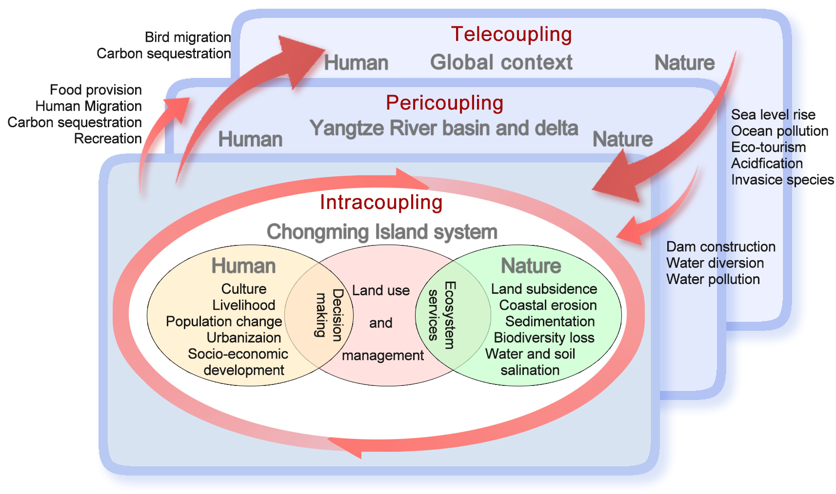
In an estuarine island system, humans induce a wide range of physical, chemical, and biological disturbances. Such disturbances include direct impacts such as landscape modification through land use change and enhancing connectivity with the mainland. Indirect impacts arise from changes in climate and the marine ecosystem, along with activities in the river catchment such as impoundments and accelerated soil erosion. These processes affect estuarine island systems such that the island system integrates with a diverse range of forces at local, regional, and even global scales, as illustrated in Figure 1. A systems perspective is therefore needed to reveal the complex dynamics of island development. The concept of coupled human-environment systems [20,21] or coupled human and natural systems (CHANS) [22,23] can be applied to better understand the evolution of the island and its wider connections. Thus, estuarine islands, located at the conjunction of rivers and oceans, offer potentially valuable insights to improve our understanding of the nature and scale of anthropogenic processes.
Since knowledge of the past offers an important perspective in developing more reliable predictions of the future, understanding the historical evolution of estuarine islands is essential for evaluating their current challenges and assisting in islands achieving a more sustainable future. Such knowledge is well-preserved in the geomorphological evolution of the island, in other words, how the island has interacted with its surrounding river(s) and ocean system through expansion or contraction of its coastline. The geomorphological evolution of an island is the result of coupled natural and anthropogenic processes within the complex system.
This paper aims to develop an understanding of the dynamics of the estuarine Chongming Island, Shanghai, China. Materials and data obtained and reviewed include: Previously published studies relating to Chongming, the Yangtze River Estuary, or Shanghai; grey literature of historical records in the form of statistics, graphs, news items, and memoirs of Chongming; governmental reports and white papers, policy documents, and strategic plans that concern the natural environment and socio-economic development of Chongming. The evidence is analyzed in relation to the following objectives: (1) To review the geomorphological evolution of Chongming Island; (2) to map changes in the island’s coastline in relation to sediment dynamics through analysis of historical maps and remote sensing imagery; (3) to evaluate the range of factors that have driven the evolution of the island at local to regional coupled scales, and; (4) to present a conceptual framework of an estuarine island system in a metacoupled world, in which knowledge of the temporal and spatial characteristics of islands are considered as both a valuable benchmark for the surrounding region and as a potential key to evaluating future sustainability in the Anthropocene.
2. Briefs on Chongming Island
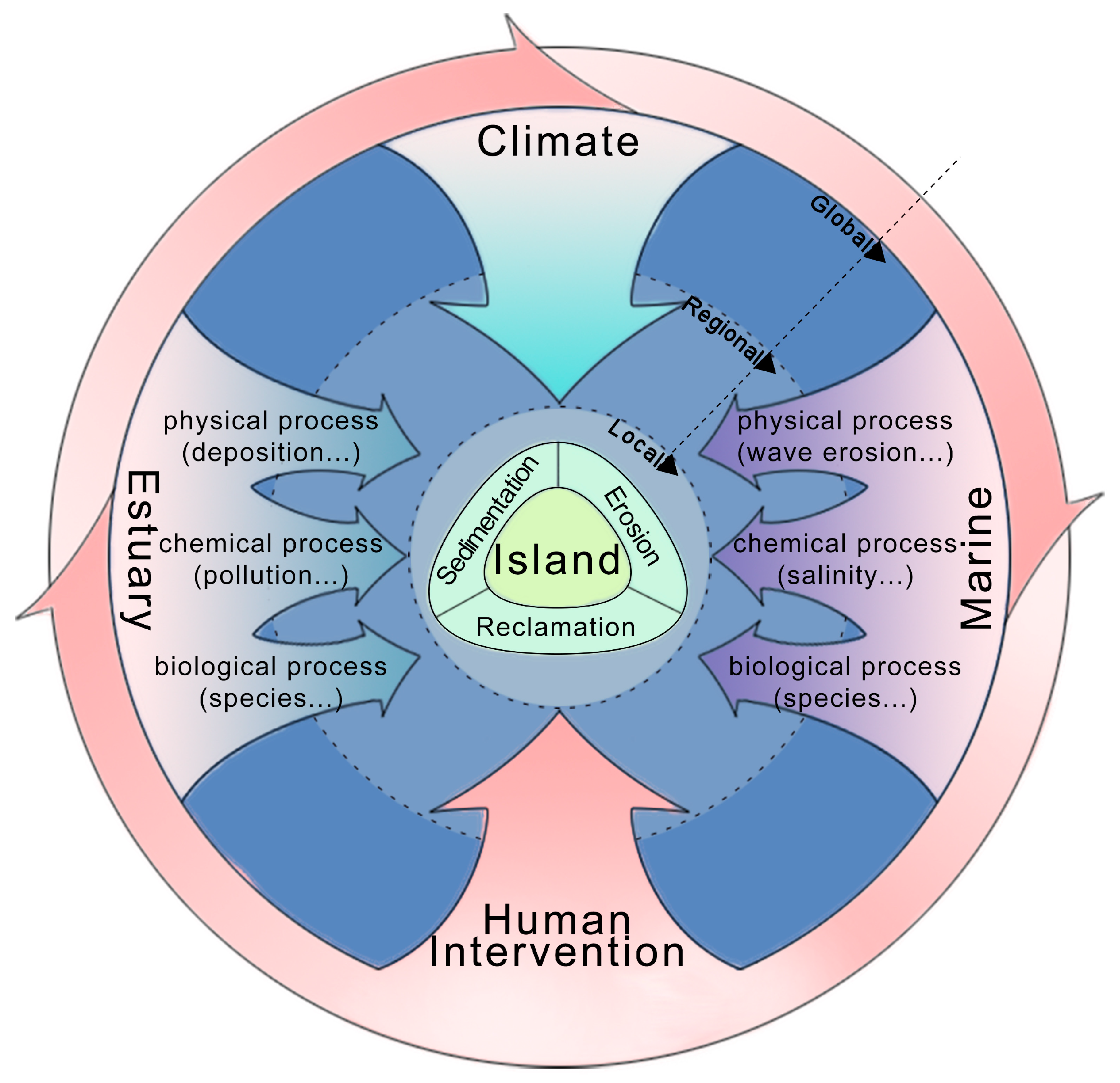
Chongming Island (121°09′30″~121°54′00″ E, 31°27′00″~31°51′15″ N) lies in the Yangtze Estuary, in the central section of the coastline of eastern China facing the East China Sea (Figure 2). The island is located in the estuary of one of the world’s largest and busiest rivers and lies adjacent to one of the world’s greatest megacities. It is flat and characterized by low elevation because 90% of its area lies between 3.47 and 5.07 m annual mean sea level (mean 4.12 m) [24]. Generally, negligible relief in the area provides ample space for the development of a substantial delta [25], and the island is strongly influenced by the dynamics of suspended sediment delivery, which is in turn affected at once by both river discharge and tidal characteristics [26]. Given its geomorphological situation, the formation and evolution of Chongming Island is a result of the dynamic processes of sediment delivery, deposition, and erosion in the estuary of the Yangtze River. The island now covers 1349.20 km2 and is increasing in size over time due to ongoing sedimentation (Figure 3). The climate of the island is subtropical with distinctive seasons, with a mean annual temperature of 15.9℃ and a mean annual precipitation of 1127.7 mm [27], providing a habitat for natural ecosystems but one equally suited to agriculture, among other land uses.
Administratively, the island originally fell under the jurisdiction of Jiangsu Province but was officially incorporated into Shanghai in 1958. In 2016, Shanghai made an adjustment to its administrative divisions, whereby Chongming county and two nearby islands (Changxing Island and Hengsha Island) were merged into a single district, the Chongming District. However, a small part of the island in the north still belongs to Jiangsu Province, where two small islands joined with Chongming Island after the incorporation in 1958 [28].
According to the statistics [29]: By the end of 2017, the registered population was 675,875, with a negative growth rate of −5.01‰, and an urbanization rate of 45.8%, which is considerably lower than that of Shanghai city (87.6%); the GDP of Chongming Island is only 1% of the total GDP of Shanghai; primary and secondary industry account for 6.6% and 41.6% of the total GDP, respectively, while traditional forms of agriculture are dominant and account for 47.4% of GDP.
3. Geomorphological Evolution
3.1. Formation and Evolution
The first ever recorded mention of Chongming Island was made during the Wude period of the Tang Dynasty (618–626 AD) when two sandy islands, named Xisha (west sand island) and Dongsha (east sand island), were formed in the middle of the Yangtze River Estuary [28,30,31]. Over the course of the next 1400 years, the geomorphological situation has been highly dynamic, with new islands emerging and being submerged again or amalgamating with one another inconsistently.
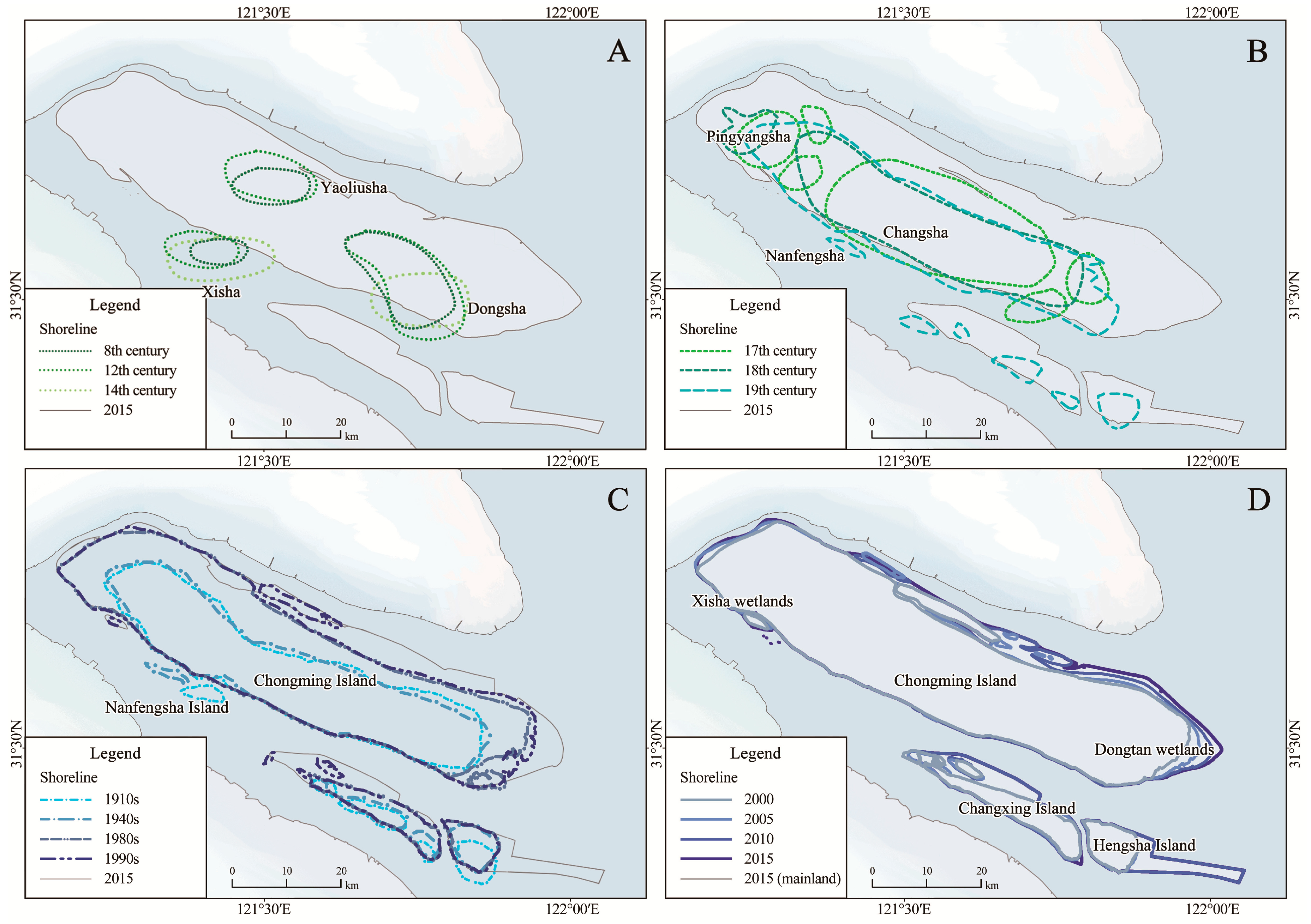
The evolution of Chongming Island can be envisaged as falling into two phases: A dynamic formation-collapse phase (Figure 3A,B), and a more stable expansive phase (Figure 3C,D).
8th to 14th century (Figure 3A): The dominant forcing factors in the dynamic phase were natural processes of sediment deposition by the Yangtze River, forming small sand islands that were scattered and unstable in their size and location.
17th to 19th century (Figure 3B): Multiple sand islands had gradually formed into an elongated island by the 19th century. There was little evidence of human interference in relation to the island’s coastline up to this time as the island transformed into a relatively stable state [30], although there was some repositioning consequent on limited expansion to the north and retreat to the south.
20th century (Figure 3C): The expansion of Chongming Island has been much more evident in the 20th century as its island area increased from around 600 km2 in the 1950s to over 1200 km2 at the end of the century. This expansion came about substantially because of land reclamation, especially between the 1950s and the 1980s [32,33].
21st century (Figure 3D): Reclamation activities have been more limited in the last two decades, and natural sedimentation processes have also slowed down due to the construction of upstream impoundments [34,35]. In general, however, the island is still expanding, particularly on the eastern, western, and northern sides.
To different degrees, natural and anthropogenic forces have been operating during both of the evolutionary phases. Sedimentation is the main driver behind the natural geomorphological evolution of Chongming Island, with integrated processes of erosion and deposition resulting from factors such as the Coriolis force [36], tidal action, typhoons, storm surges, floods, strong winds, and other extreme events.
3.2. Sediment Dynamics
Wave erosion and sediment deposition occur simultaneously and have characterized both dynamic and stable phases during the evolution of Chongming Island. On one hand, deposition and erosion in the tide-dominated estuary have promoted natural expansion of the island over time; indeed, islands extending parallel to the main tidal flow are often associated with the conjunction of fluvial and marine systems [37]. On the other hand, factors associated with the Coriolis force have determined the NW-SE elongated morphology of the island [38]. Because of this effect, the river’s discharge is deflected and is more erosive in the southern arm of the estuary, while lower energy in the northern arm facilitates more deposition. Therefore, fluvial processes have generally been more active on the southern shores, especially following the merging of the islands during the 18th century [28] (Figure 3B), which constricted the northern river channel and exposed the southern shoreline to greater erosion intensity. Thereafter, the main spillway of the Yangtze Estuary shifted to the southern branch, which further intensified erosion towards the southern shores and deposition in the northern shores [39].
Current processes of deposition and erosion in this situation can be characterized by two types of shorelines; viz. arcuate and smooth. Arcuate shorelines, characterized by more prominent deposition, extend along the north-eastern, western, and eastern coasts of Chongming Island and are associated with wetlands and tidal creek systems. Smooth shorelines extending along the southern coast were formed by sea walls built to protect the coast from erosion, as well as by land reclamation during the last decade, such as the central part of the northern coast (which belongs to Jiangsu Province).
3.3. Effects of Typhoon and Storm Surges
The sedimentation-formed islands on the river estuaries are extremely vulnerable to wave, tide, and storm-induced erosion. The dynamic nature of an estuary the size of the Yangtze means that small islands frequently form and then collapse due to ongoing erosion. Typhoons and storm surges in particular have destructive effects on the islands [40,41]. As can be seen in Table 1, flooding, storm surges, typhoons, and rainstorms have caused casualties, destroyed constructions, damaged farmlands, and shut down electricity, while, geomorphologically, these extreme events have consequences in extensive erosion of the island, and sometimes even collapse of the island altogether.
Nanfengsha, a sand island just to the south of the central part of Chongming Island (Figure 3B,C) is a typical recent example of this. The island was formed during the 1860s [44] and, despite its small size, historical records suggest that its inhabitants were able to attain successful livelihoods. The island had been shifting its position westwards due to ongoing erosion on the east while undergoing reclamation on the west [44] but has decreased in size, especially due to intensified erosion following the reinforcement of the Chongming Island sea walls [45]. Moreover, extreme tidal and wave conditions associated with the strong typhoons of 1949 and 1956 consumed the island [43], completely destroying properties and forcing the residents to relocate. Due to storm and wave related erosion, the island that had been in existence for more than a hundred years had disappeared altogether by 1976 [43].
4. Human Impacts on Island Dynamics
4.1. Human Inhabitation and Population
People migrate from the mainland to islands for a wide range of reasons and, in the process of occupation impact the landscape and alter the sedimentary environment and shorelines. In the case of the coastline of Chongming Island, the two most important interventions have been land reclamation and the construction of sea walls, both of which have intensified as the population has expanded.
Humans first came to Chongming in 696 AD, shortly after the island emerged from the water, for fishery and agricultural activities [28,30]. Throughout the occupational history of Chongming Island, the administrative center of Chongming has been relocated and reconstructed at least five times (1352, 1420, 1529, 155, and 1583) due to erosion and collapse of the island [43] (Table 2). Through the construction and continuous reinforcement of sea walls, the current location of the administrative center has been able to remain since the last relocation [43,46].
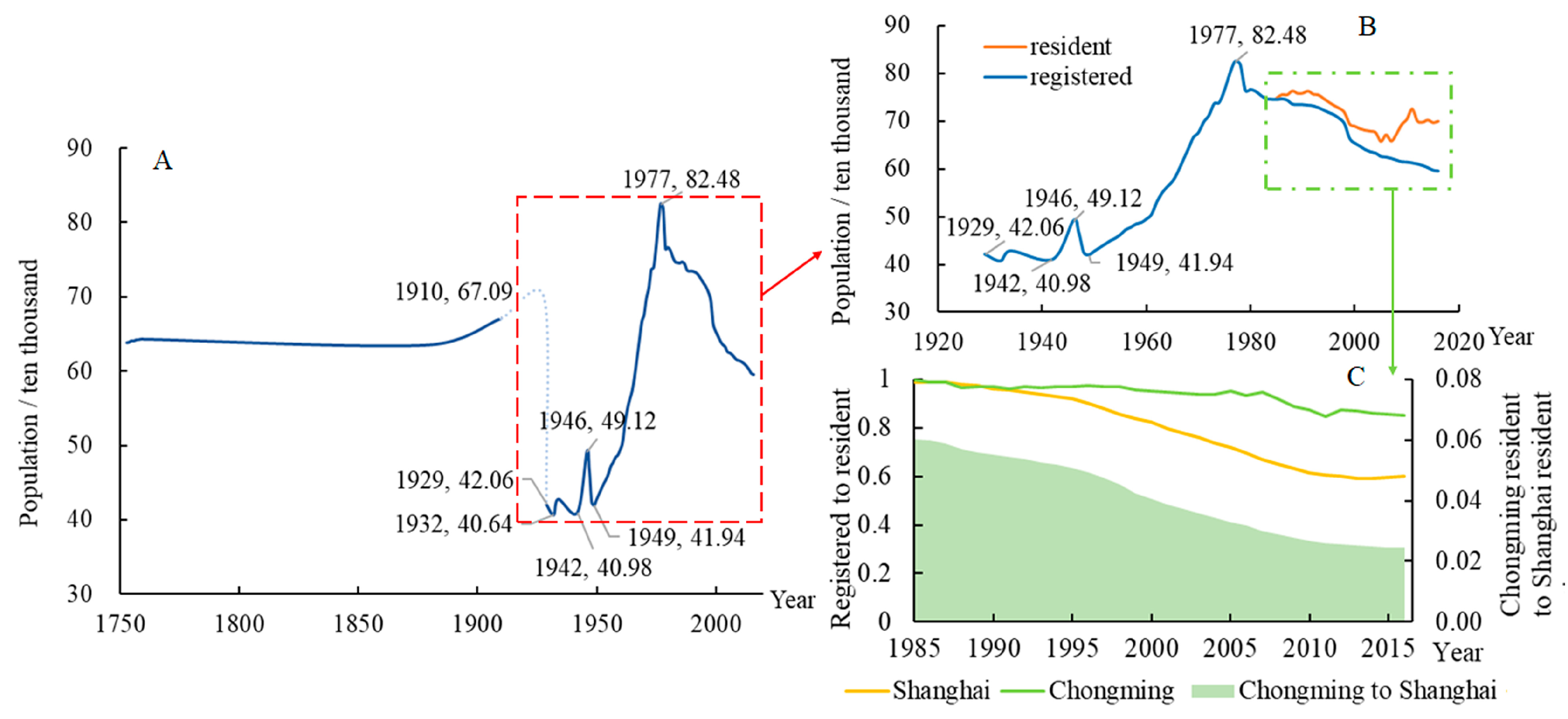
As illustrated in Figure 4, Chongming has experienced pronounced population fluctuations over time. Since 1929, three phases of human occupation can be identified, which parallel trends in the intensity of the interactions between human activities and natural processes:
Phase 1: 1929–1948. Population fluctuated markedly during this time of political turbulence and conflict, during which crop failure (especially in 1947) led to severe famine.
Phase 2: 1949–1978. After the founding of the People’s Republic of China, considerable agricultural and industrial development promoted the living standards of the island’s residents. During large-scale and government-organized land reclamation projects, many young students (“educated youth”) were recruited [48], which contributed to the growth in population as well as putting pressure on land productivity.
Phase 3: 1978–present. The Reform and Opening policy established in 1978 led to accelerated urbanization, increased employment opportunities, and improved living conditions in Shanghai, meaning that the city became a great deal more attractive than the island. During this time, many of the original recruits (now with their own families) migrated back to the city. The population of Chongming Island has been falling ever since.
Due to the migration of youngsters seeking better opportunities in mainland Shanghai, the population age demographics in Chongming have also changed radically. In 1964, those over the age of 60 accounted for 6.66% of the total population and 7.91% by 1972, but had risen to 31.19% in 2016 and 35.20% in 2017 [29,49]. The ratio of registered population to resident population in Chongming Island is declining but at a significantly lower level than it is in Shanghai, revealing the consequence of its divided strategic focus and priority (Figure 4C).
4.2. Land Reclamation
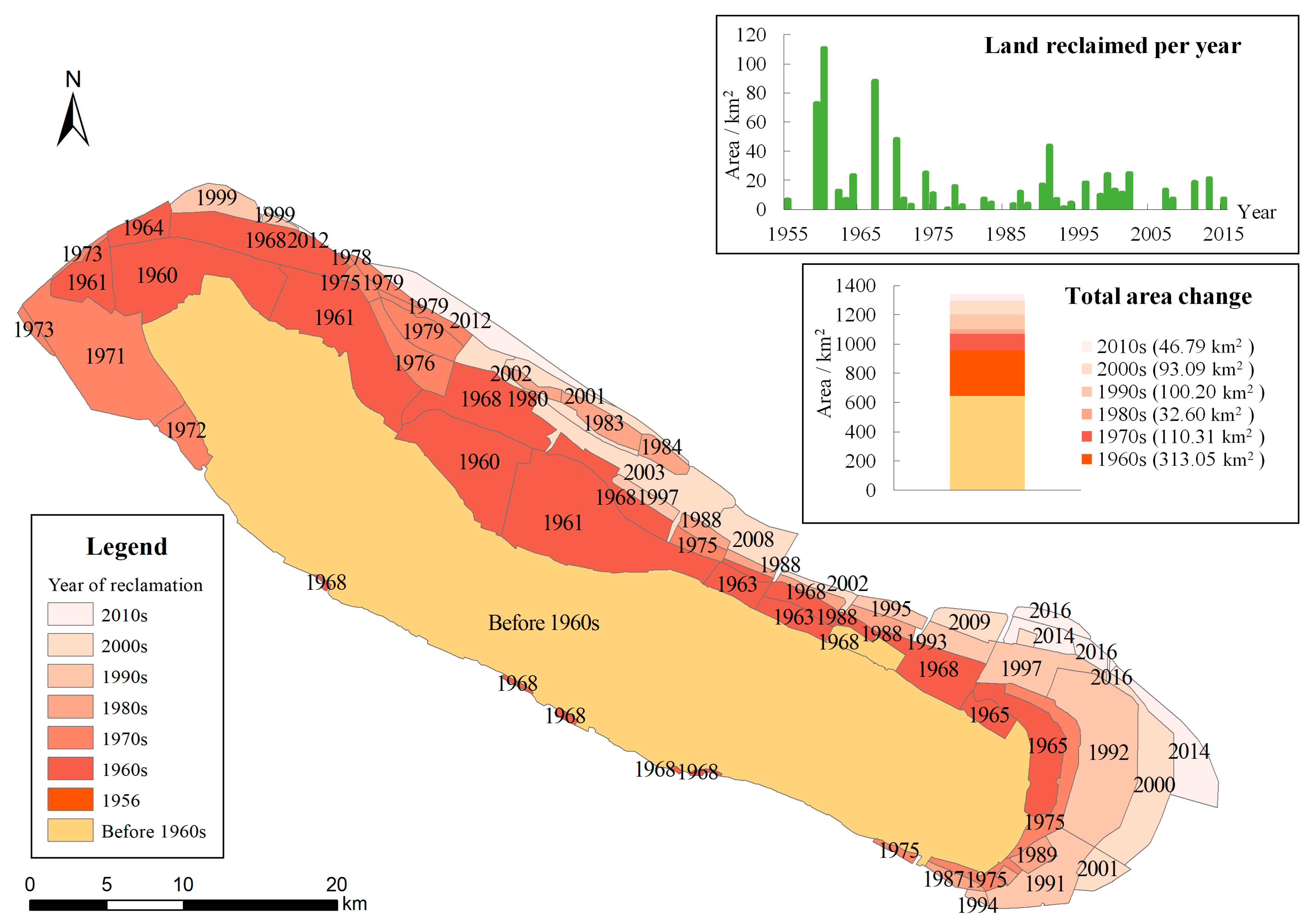
Chongming has a long history of land reclamation. Once the sand island reached a certain elevation above sea level and seemed to be relatively stable, people tried to reclaim and appropriate it, only decades after it emerged from the estuary (as in Table 2). However, due to their small size and insufficient protection, such sand islands often collapsed during typhoons and storm surges. According to newspaper reports, sand islands in the Yangtze Estuary, the largest of which reached 4 km2, were occupied some nine times between 1917 and 1948 [43]. Systematic, large scale land reclamation started in 1956 for the purpose of meeting the supply of non-staple food, which was in severe shortage at the time, in Shanghai city [32,48], and the first project of 8.27 km2 was established in the north-eastern part of the island. Major land reclamation projects have doubled the size of Chongming Island in the past six decades (Figure 5), most of which have been located around the eastern, western, and northern shorelines, which offer advantageous natural sedimentary conditions (as noted in Section 3.2).
Accordingly, large-scale reclamation has changed the hydrodynamic environment [50] through the narrowing of the northern branch of the Yangtze River, which has reduced discharge and sediment yield, thus further modifying geomorphologic conditions. While there are considerable economic benefits emanating from “mining the lands from the water”, there are associated environmental consequences and loss of ecosystem services. For example, the invasive grass Spartina alterniflora, which is well adapted to the eutrophied waters of the Yangtze Estuary, was introduced in 2000 to promote silting in the reclaiming process [51,52]. Such activities come at the cost of losing what was previously wetland or open water resources in the estuary and are among the anthropogenic triggers that have seen the loss of biodiversity in both aquatic and bird communities [50,53,54].
4.3. Sea Walls
Since the beginning of human occupation, the population of the island has faced numerous environmental challenges that include frequent coastal erosion and flooding brought about by natural disasters that destroyed land, houses, and livelihoods, as shown in Table 1. Sea walls are constructed to combat coastal flooding and island collapse [43,46]: The first sea wall was constructed as early as 1544, but ongoing damage by tides and storms over the centuries has required many others to be constructed or reconstructed since then. The first large scale sea wall was made in 1762 from mud, and it extended for 100 km along the Chongming coastline. The first stone sea wall was built in 1894, although it was built along only 2km of the coast to protect the administration center. By 1949 there were some 178 km of disconnected sea walls around Chongming Island; these were consolidated and reconstructed to 207 km in 1977.
Further construction and reinforcement of sea walls has been undertaken over the last few decades in association with land reclamation. Improved design standards and construction at an elevation of not lower than 8 m, with a width of not less than 5 m, have resulted in protection of the entire perimeter of Chongming Island. As the Shanghai Environment Yearbook [55] notes, the engineering standards have been designed to withstand a 50-year storm surge return period or a typhoon of magnitude 11. Currently, the sea wall of Chongming Island stretches around 230 km, and the most recent planned reinforcement is designed to withstand a 100-year storm surge return period and typhoon of magnitude 11; indeed, some areas have walls with specifications for a 200-year storm surge return period and magnitude 12 typhoon [55].
4.4. Upstream Water Resource Management Construction
Rivers are major pathways for delivering terrestrial materials such as freshwater, sediment, and nutrients to the ocean, and their sediment loads are directly responsible for the formation and evolution of estuarine islands [56]. The Yangtze Estuary has been impacted by a range of natural and anthropogenic factors from upstream [56,57]. Chongming Island receives sedimentary inputs from the Yangtze River Basin. Human activities in the river catchment influence discharge and sediment load, as well as its physical and chemical characteristics, which in turn impact the geomorphological evolution of Chongming.
The erection of large-scale water management structures, in particular the Three Gorges Dam and the South-to-North Water Transfer Project [58,59], exert a strong influence on discharge and sediment transport, which has implications for the Chongming Island environment. Before 1998, sediment loads of 4 × 10⁸ t/yr were characteristic [58], as upstream population growth and land use change accelerated soil erosion and increased sediment delivery to the lower reaches. However, due to construction of more than 50,000 dams in the Yangtze River Basin, sediment transport rates have declined from an average of 4.99 × 10⁸ t/yr in the 1960s to 4.39 × 10⁸ t/yr in the 1980s and 3.40 × 10⁸ t/yr in the 1990s, finally reaching 1.45 × 10⁸ t/yr in the 2000s [60]. Since the completion of the Three Gorges Dam (TGD) in 2006, sediment delivery below the impoundment has declined by more than 80% [61].
The geomorphic consequences of this have been significant as downstream sediment transport delivery has decreased, and there has been a concomitant increase in erosivity, especially below the TGD. The eastern shoreline of Chongming Island (Dongtan) expanded consistently by more than 500 m/yr between the 1950s and the 1970s, but the rates declined to 200–300 m/yr between the 1980s and the 2000s [62,63] and were further reduced to just 20 m/yr between 2006 and 2008 [64]. The South-to-North Water Transfer Project, which diverts water from the Yangtze River Basin in southern China to the Yellow River Basin in northern China, was planned to alleviate the water shortage situation in arid northern China, and the first of three phases was completed and became operational in 2013. Reduction in runoff has aggravated salt water intrusion into the Yangtze Estuary [59,65], especially in the northern branch [66].
Substances carried in the Yangtze River and sourced in the catchment affect the local environmental quality of Chongming Island in the form of accumulating heavy metal and organic pollutants, especially in the wetlands and drainage channels [67,68]. In addition, eutrophication involving soil bacteriological changes appears to favor the introduced and invasive grass Spartina alterniflora [51,52]. Fish and birds in particular are threatened by contamination or habitat loss resulting from the invasive alien species [53].
4.5. Sea Level Rise
Globally, rising sea levels [69] and associated salt-water intrusion [70] threaten many low-lying coastlines and islands. These areas are also strongly influenced by more frequent and extreme hydroclimatic events and wave-driven flooding [71]. For an island such as Chongming, therefore, the combined manifestations of climate change represent a major threat. The average rate of sea level rise from 1993 to 2016 was 0.39 cm/yr along the Chinese coast as a whole and 0.36 cm/yr in Shanghai; both are higher than the world average of 0.34 cm/yr (State Oceanic Administration of China, 2017). Such problems are exacerbated by land subsidence [72]. The rate of land subsidence in the Yangtze Estuary area generally has been estimated as 0.4 cm/yr [73], but higher (between 0.5 to 1 cm/yr) around the eastern shore (Dongtan) and lower (0 to 0.5 cm/yr) in the rest of Chongming Island [74]. Hence, recent sedimentation rates in the Yangtze Estuary of 3.28 to 3.36 cm/yr [34,35] are still higher than the rate of land subsidence and sea level rise combined.
However, taking 2000 as a baseline, the IPCC A1 scenario of sea level rise during 2090–2099 is 26 to 59 cm and, according to the IPCC RCP8.5 greenhouse gas scenario, sea level rise is likely to be 45 to 82 cm during 2081–2100 (IPCC, 2014). It is estimated that much of the Dongtan area will be inundated by the year 2100 because of an estimated 0.88 m sea level rise [75]. Furthermore, when considering the combined risk from sea level rise, land subsidence, and storm surges, models have projected that the south bank of Chongming Island will be overtopped and more than 50% of the island will be inundated by 2100 [76]. Hence, the increasing rate of sea level rise indicates that low-lying Chongming Island is at critical levels of risk in the future. Moreover, in large deltaic and estuarine systems such as the Yangtze, sea level rise also exacerbates salt water intrusion that, in turn, threatens to ends the social and ecological security of the island. Tidewater intrusion may cause soil salinization and a freshwater crisis on the island. Furthermore, soil salinization has significantly negative impacts on agricultural productivity of the island [77], a situation that is further aggravated by fluvial diversion and dam construction upstream such that elevated-salinity incidents in the estuary may increase in frequency [78].
5. Islands in a Metacoupled World
Natural processes are the initial fundamental drivers of landscape change, but humans modify landscape patterns both directly and indirectly. As illustrated in this paper, anthropogenic forces directly or indirectly integrate with natural processes (as in Figure 1) with increasing intensity over time. The geomorphological evolution of Chongming Island resulted from human intervention and modification of natural processes towards the prevention of erosion, mitigation of extreme events, and socio-ecological development. Anthropogenic forces have interacted with the natural processes of sediment dynamics involving deposition and erosion that continue to reshape the island. Constriction of the northern river channel favored deposition and allowed for further reclamation. Meanwhile, large-scale construction has irreversibly modified the landscape, freshwater reservoirs, and sea walls. Considering the way that decision-making has varied during different periods of socioeconomic development of the island, driven by changing population and associated demands, the human and environment system can be said to be co-evolving, and therefore coupled.
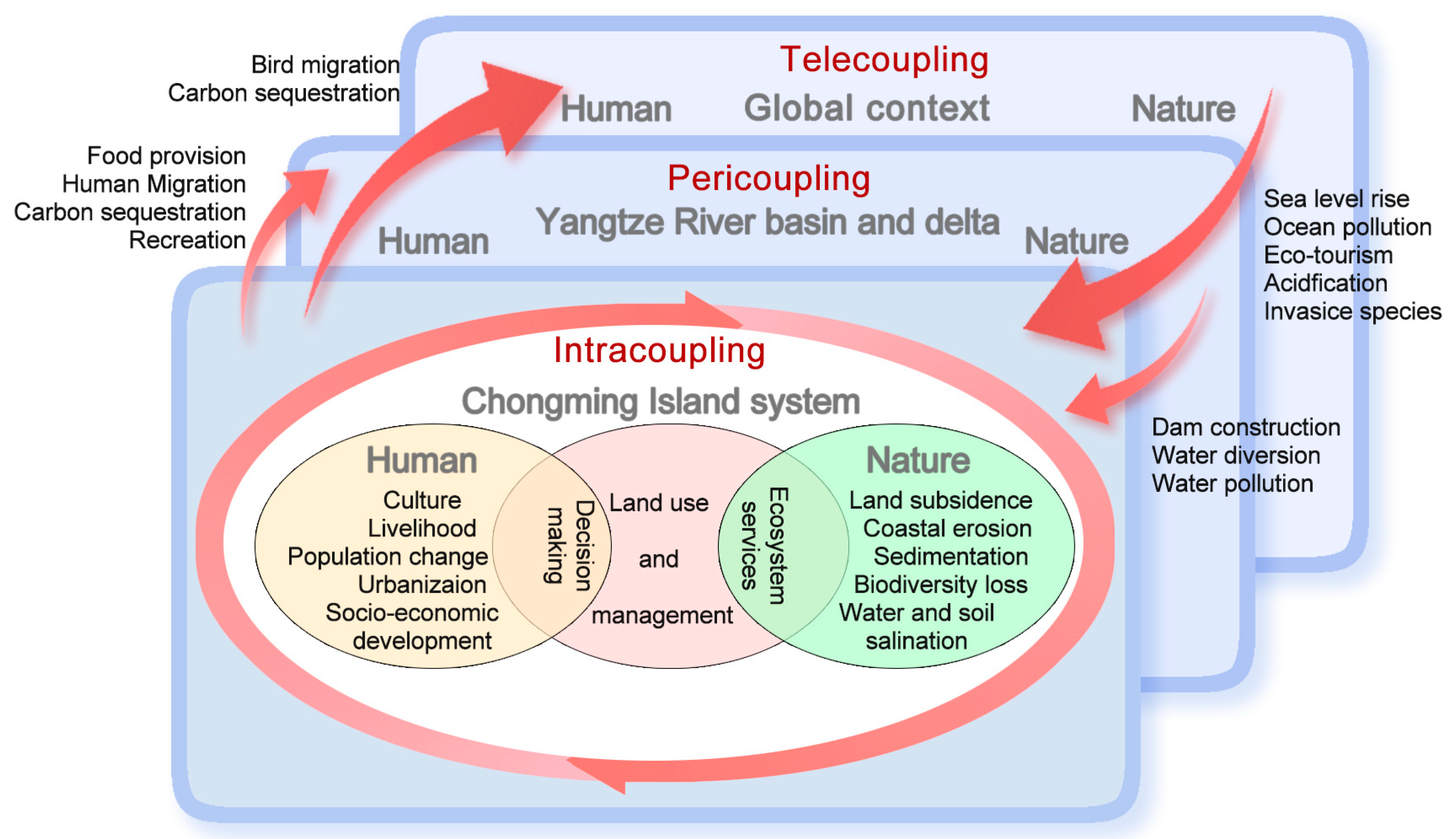
The coupling in Chongming Island is, however, beyond local, as integration takes place at different intensities and scales, thereby forming a metacoupled human-environment system [79,80]. As presented in the study, the relationships between the various factors and processes of Chongming Island can be conceptualized as operating at three scales, viz., intracoupling, pericoupling, and telecoupling, which arise from integrated human-environmental interactions on the island in local, regional, and global contexts (in Figure 1). Following the arrows in Figure 6, which indicates the origin and destination of (material, energy, and information) flows from the sending system, receiving system, and spillover system [79,80], Chongming Island is pericoupled with the Yangtze River Basin and Delta, and telecoupled in a global context. For instance, the island is a sending system that provides food, recreation, and other resources, while Shanghai is the receiving system; on the other hand, the island is receiving sedimentation and pollutants from upstream where, in this case, the entire Yangtze River Basin is a sending system. In the global context, Chongming Island is a major bird habitat and migration node that is both a sending and a receiving system; meanwhile, the island is at risk of sea level rise, whereby the rest of the world is a spillover system in terms of CO2 emissions [79].
As Libby Robin argues, no island is really an island [82], and the future of Chongming Island in a metacoupled world lies in the nature of its intracoupled, pericoupled, and telecoupled relationships. Accordingly, developing an island that respects its natural and cultural history, improves its resilience, while benefiting people socially, economically, and ecologically across scales, requires comprehensive thinking and interdisciplinary knowledge that bridges the gap between scientific research, decision making, and implementation of policy.
At times in the past, Chongming was a magnet for migrants from the mainland who came in their droves to cultivate its rich soils, the outcome of which was rapid population growth and island expansion supported by government policy. When island life became less tempting than the shining lights of Shanghai city, a reduced and aging population was left behind [29].
Now there are new initiatives and opportunities for the island. Recent government documents signal a policy shift that envisages Chongming as an island with enhanced ecological wealth [83,84] and as a place that showcases the potential of advanced resource utilization, sustainable socio-economic development, strong ecosystem resilience, and ecological promotion and protection [85,86]. To achieve such goals, the human and natural interactions are being closely monitored, and should be strictly managed in the coming decades [87]. In this case, the promotion of clean and green, and restriction of traditional industrial development is expected, so as to maintain an eco-island system that provides the Chongming residents with sustainable livelihoods as well as a “spillover system” benefiting Shanghai. This is the vision of Shanghai as a pericoupled “World-class Eco-Island” [47], one in which its emerging opportunities will again be deeply driven by the jurisdiction and policies of the mainland.
In addition, telecoupling ensures that Chongming is subject to a number of global-scale challenges (Figure 6), such as climate change and associated, which impact a range of geomorphological and ecological processes [88]. The rate and direction of expansion of new land around the island reflects the hydrological condition resulting from the integration of factors such as sea level rise, extreme events, sediment deposition, tidal dynamics, etc. In turn, these processes impact a range of ecosystem characteristics, for example trophic structure, species diversity, biological productivity, and soil carbon stock of wetlands, which are indicators of the changing environment [89]. Correspondingly, other estuaries and estuarine islands are also indicators of local and global environmental challenges. For examples, fish and fauna in an urbanized region of the Amazon Estuary that are able to indicate local environment quality [90], changes of estuarine zooplankton in the Long Island Sound of New York [91], shoreline changes of the Cedar Island of North Carolina [92], and flood propagation and reservoir operation in the Mekong River [93,94] are all able to reflect the impact of climate change and sea level changes.
These cases indicate both sensitivity and speed of response to shifts in environmental conditions at local, regional, and global scales. Meanwhile, intense human activities, driven by socio-economic globalization, further complicate natural factors through, for example, land use management, eco-tourism, high-tech investment, real estate development, mining, and industrialization, among others. The future of estuarine and peripheric islands is intricately bound, through telecoupling, to both humans and nature. Their responses make them the significant test beds towards finding solutions for general global challenges.
6. Conclusions
Chongming offers us an informative case study that reveals how hydro-geomorphological dynamics and human activities interact in an evolving island context. Throughout its relatively short history, Chongming Island has been influenced by hydrological and sedimentological forces related to both estuarine and marine systems under persistent and intensifying direct and indirect human activities. Over the past few decades, the island has undergone significant "shifts" both in terms of its physical shorelines and landscapes, and their corresponding socio-economic drivers. These complex dynamics are consequent upon an array of intracoupled factors. Considering its pericoupled relationship with the mainland throughout its evolution, together with its current strategic position in the Yangtze River Delta metropolis, understanding the regional connectivity of Chongming is a key to exploring adaptive ways towards future sustainability in the Anthropocene. Note also that Chongming Island is telecoupled, as its coastal wetlands are especially vulnerable and ecologically sensitive to climate change and related challenges. There are lessons here for estuarine islands in particular.
Islands are harbingers of global environmental change, but also ideal model systems that enable us to better understand global and regional human-environmental system change. Indeed, islands such as Chongming may prove to be pioneers for building sustainability in coastal megacities in the Anthropocene.
Author Contributions
Conceptualization, S.W., R.C. and M.E.M.; methodology, S.W. and R.C.; software, S.W.; validation, S.W., R.C., and M.E.M.; investigation, S.W. and R.C.; resources, S.W. and R.C.; data curation, S.W. and R.C.; writing—original draft preparation, S.W., R.C., and M.E.M.; writing—review and editing visualization, S.W.; supervision, R.C. and M.E.M.; project administration, S.W. and R.C.; funding acquisition, R.C.
Funding
This study was funded by the National Key R&D Program of China (2017YFC1503001), the National Natural Science Foundation of China (grant number 41771119), and the Research Fund of the Geological Mineral Resources and Environmental Exploration Program (DD20190463), and the support from the Institute of Eco-Chongming (IEC), East China Normal University.
Conflicts of Interest
The authors declare no conflict of interest.
References
- Szabó, J. Anthropogenic Geomorphology: Subject and System; Springer: Berlin/Heidelberg, Germany, 2010; pp. 3–10. [Google Scholar] [CrossRef]
- Lewis, S.L.; Maslin, M.A. Defining the anthropocene. Nature 2015, 519, 171–180. [Google Scholar] [CrossRef] [PubMed]
- Meadows, M.E. Geomorphology in the anthropocene: Perspectives from the past, pointers for the future? In Geomorphology and Society; Meadows, M.E., Lin, J.C., Eds.; Springer: Tokyo, Japan, 2016; pp. 7–22. [Google Scholar] [CrossRef]
- Cooper, A.H.; Brown, T.J.; Price, S.J.; Ford, J.R.; Waters, C.N. Humans are the most significant global geomorphological driving force of the 21st century. Anthr. Rev. 2018, 5, 222–229. [Google Scholar] [CrossRef] [Green Version]
- Rockström, J.; Falkenmark, M.; Allan, T.; Folke, C.; Gordon, L.; Jägerskog, A.; Kummu, M.; Lannerstad, M.; Meybeck, M.; Molden, D.; et al. The unfolding water drama in the anthropocene: Towards a resilience-based perspective on water for global sustainability. Ecohydrology 2014, 7, 1249–1261. [Google Scholar] [CrossRef]
- Rockström, J.; Steffen, W.; Noone, K.; Persson, Å.; Chapin, F.S.; Lambin, E.; Lenton, T.M.; Scheffer, M.; Folke, C.; Schellnhuber, H.J. Planetary boundaries: Exploring the safe operating space for humanity. Ecol. Soc. 2009, 14, 292. [Google Scholar] [CrossRef]
- Kirch, P.V. Microcosmic histories: Island perspectives on “global” change. Am. Anthropol. 1997, 99, 30–42. [Google Scholar] [CrossRef]
- Kirch, P.V. Oceanic islands: Microcosms of “global change”. In The Archaeology of Global Change: The Impact of Humans on Their Environment; Redman, C.L., James, S.R., Fish, P.R., Rogers, J.D., Eds.; Smithsonian Books: Washington, DC, USA, 2004; pp. 13–27. [Google Scholar]
- Rick, T.C.; Kirch, P.V.; Erlandson, J.M.; Fitzpatrick, S.M. Archeology, deep history, and the human transformation of island ecosystems. Anthropocene 2013, 4, 33–45. [Google Scholar] [CrossRef]
- Briguglio, L. Small island developing states and their economic vulnerabilities. World Dev. 1995, 23, 1615–1632. [Google Scholar] [CrossRef]
- González, J.A.; Montes, C.; Rodríguez, J.; Tapia, W. Rethinking the Galapagos Islands as a complex social-ecological system: Implications for conservation and management. Ecol. Soc. 2008, 13, 582–592. [Google Scholar] [CrossRef]
- Walsh, S.J.; Mena, C.F. Perspectives for the Study of the Galapagos Islands: Complex. Systems and Human-Environment Interactions; Springer: New York, NY, USA, 2013; pp. 49–67. [Google Scholar] [CrossRef]
- Walsh, S.J.; Mena, C.F. Interactions of social, terrestrial, and marine sub-systems in the Galapagos Islands, Ecuador. Proc. Natl. Acad. Sci. USA 2016, 113, 14536–14543. [Google Scholar] [CrossRef] [Green Version]
- Goldstein, J.H.; Caldarone, G.; Duarte, T.K.; Ennaanay, D.; Hannahs, N.; Mendoza, G.; Polasky, S.; Wolny, S.; Daily, G.C. Integrating ecosystem-service tradeoffs into land-use decisions. Proc. Natl. Acad. Sci. USA 2012, 109, 7565–7570. [Google Scholar] [CrossRef] [Green Version]
- Mann, D.; Edwards, J.; Chase, J.; Beck, W.; Reanier, R.; Mass, M.; Finney, B.; Loret, J. Drought, vegetation change, and human history on Rapa Nui (Isla de Pascua, Easter Island). Quat. Res. 2008, 69, 16–28. [Google Scholar] [CrossRef]
- Brown, K.; Turner, R.K.; Hameed, H.; Bateman, I.J. Environmental carrying capacity and tourism development in the Maldives and Nepal. Environ. Conserv. 1997, 24, 316–325. [Google Scholar] [CrossRef]
- Holdschlag, A.; Ratter, B.M.W. Caribbean island states in a social-ecological panarchy? Complexity theory, adaptability and environmental knowledge systems. Anthropocene 2016, 13, 80–93. [Google Scholar] [CrossRef]
- Fitzpatrick, S.M.; Erlandson, J.M. Island archaeology, model systems, the anthropocene, and how the past informs the future. J. Isl. Coast. Archaeol. 2018, 13, 283–299. [Google Scholar] [CrossRef]
- Bianchi, T.S.; Allison, M.A. Large-river delta-front estuaries as natural “recorders” of global environmental change. Proc. Natl. Acad. Sci. USA 2009, 106, 8085–8092. [Google Scholar] [CrossRef] [Green Version]
- Chen, P.; Chen, X. Summary on research of coupled human-environment system vulnerability under global environmental change. Prog. Geogr. 2010, 29, 454–462. [Google Scholar] [CrossRef]
- Turner, B.L.; Matson, P.A.; McCarthy, J.J.; Corell, R.W.; Christensen, L.; Eckley, N.; Hovelsrud-Broda, G.K.; Kasperson, J.X.; Kasperson, R.E.; Luers, A. Illustrating the coupled human–environment system for vulnerability analysis: Three case studies. Proc. Natl. Acad. Sci. USA 2003, 100, 8080–8085. [Google Scholar] [CrossRef] [Green Version]
- Liu, J.; Dietz, T.; Carpenter, S.R.; Alberti, M.; Folke, C.; Moran, E.; Pell, A.N.; Deadman, P.; Kratz, T.; Lubchenco, J. Complexity of coupled human and natural systems. Science 2007, 317, 1513–1516. [Google Scholar] [CrossRef] [Green Version]
- Liu, J.; Dietz, T.; Carpenter, S.R.; Folke, C.; Alberti, M.; Redman, C.L.; Schneider, S.H.; Ostrom, E.; Pell, A.N.; Lubchenco, J. Coupled human and natural systems. AMBIO J. Hum. Environ. 2007, 36, 639–649. [Google Scholar] [CrossRef]
- Shanghai Digital Elevation Model. Geographical Information Monitoring Cloud Platform. 2013. Available online: http://www.dsac.cn/DataProduct/Detail/20082007 (accessed on 6 August 2017).
- Wei, T.; Chen, Z.; Duan, L.; Gu, J.; Saito, Y.; Zhang, W.; Wang, Y.; Kanai, Y. Sedimentation rates in relation to sedimentary processes of the Yangtze Estuary, China. Estuar. Coast. Shelf Sci. 2007, 71, 37–46. [Google Scholar] [CrossRef]
- Chen, B.; Wang, K. Suspended sediment transport in the offshore near Yangtze Estuary. J. Hydrodyn. 2008, 20, 373–381. [Google Scholar] [CrossRef]
- Mu, H.; Shi, J.; Yang, H.; Ma, Y.; Xu, W.; Zhang, H. Climate change and impact assessment for Chongming Island in 1961–2016. Adv. Meteorol. Sci. Technol. 2017. [Google Scholar] [CrossRef]
- Zhang, X. The historical formation of Chongming Island. Fudan J. Soc. Sci. Ed. 2005, 3, 62–71. [Google Scholar]
- Shen, Y.; Xu, M.; Zhang, L.; Song, J.; Huang, G. Chongming Statistical Yearbook 2018; Chongming Statistics Office: Shanghai, China, 2018. [Google Scholar]
- Chu, S. The evolution of Chongming Island. Geogr. Res. 1987, 6, 9–16. [Google Scholar] [CrossRef]
- Li, X. Tratigraphic subdivisions and sedimentary environmental evolutions of the late cenozoic sequences in Shanghai region. Shanghai Land Resour. 2009, 1–7. [Google Scholar] [CrossRef]
- Wu, Y. An account of Chongming reclamation. Mem. Arch. 2016, 4, 59–61. [Google Scholar]
- Zhou, Z. Historical atlas of Shanghai; Shanghai People’s Publishing House: Shanghai, China, 1999. [Google Scholar]
- Pang, R. Modern Sedimentation Rate and Its Implications for Environmental Evolutions in the Changjiang Estuary in China. Master’s Thesis, Nanjing University, Nanjing, China, 2011. [Google Scholar]
- Ran, Q. Modern Sedimentation Rates of the Changjiang Subaqueous Delta. Master‘s Thesis, Nanjing University, Nanjing, China, 2010. [Google Scholar]
- Neill, S.P. The role of coriolis in sandbank formation due to a headland/island system. Estuar. Coast. Shelf Sci. 2008, 79, 419–428. [Google Scholar] [CrossRef]
- Seybold, H.; Andrade, J.S., Jr.; Herrmann, H.J. Modeling river delta formation. Proc. Natl. Acad. Sci. USA 2007, 104, 16804–16809. [Google Scholar] [CrossRef] [Green Version]
- Jia, H.; Liu, C.; Yang, O. Dynamic sediment environment of the north branch of Changjiang Estuary. J. East China Norm. Univ. Natl. Sci. 2001, 1, 90–96. [Google Scholar]
- Zhai, X. Preliminary Study on the Drooling Dynamics and Suspended Sedimentation Distribution Characteristics of the Yangtze River. Master’s Thesis, East China Normal University, Shanghai, China, 2006. [Google Scholar]
- Baylisssmith, T.P. The role of hurricans in the development of Reef Islands, Ontong Java Atoll, Solomon-Islands. Geogr. J. 1988, 154, 377–391. [Google Scholar] [CrossRef]
- Duperret, A.; Pomerai, M.R.D. Coastal rock cliff erosion by collapse at Puys, France: The role of impervious marl seams within chalk of NW Europe. J.Coast. Res. 2002, 18, 52–61. [Google Scholar]
- Zhang, L. Chongming Chronicles (1985–2004); China Local Records Publishing: Beijing, China, 2013. [Google Scholar]
- Zhou, Z. Chongming Chronicles (Before 1984); Shanghai People’s Publishing House: Shanghai, China, 1989. [Google Scholar]
- Pan, W. Reconstruction of erosion-deposition in Yangtze river estuary south branch and related problem study, 1681–1953. Collect. Essay. Chin. Hist. Geogr. 2009, 24, 22–28. [Google Scholar]
- Chai, T. Ups and Downs of the Old Chongming: Nanfeng Island; Wenhui Press: Shanghai, China, 2011. [Google Scholar]
- Lu, M. Chongming: From Shifting to Impregnable. Available online: http://shzw.eastday.com/eastday/city/gk/20180321/u1ai11308301.html (accessed on 14 October 2018).
- Hanghai Manicipall Government. 13th Five-Year Plan of Chongming World-Class Eco-Island Development. Available online: http://www.Shanghai.gov.cn/nw2/nw2314/nw39309/nw39385/nw40603/u26aw50776.html (accessed on 14 October 2018).
- Cai, M. Back in those days of Chongming land reclamation. Mem. Arch. 2007, 4, 31–32. [Google Scholar]
- Shen, Y.; Xu, M.; Zhang, L.; Song, J.; Huang, G. Chongming Statistical Yearbook 2017; Chongming Statistics Office: Shanghai, China, 2017. [Google Scholar]
- Li, J.; Yang, X.; Tong, Y. Progress on environmental effects of tidal flat reclamation. Prog. Geogr. 2007, 26, 43–51. [Google Scholar] [CrossRef]
- Nie, M.; Wang, M.; Li, B. Effects of salt marsh invasion by spartina alterniflora on sulfate-reducing bacteria in the Yangtze river estuary, China. Ecol. Eng. 2009, 35, 1804–1808. [Google Scholar] [CrossRef]
- Sousa, A.I.; Lillebø, A.I.; Caçador, I.; Pardal, M.A. Contribution of spartina maritima to the reduction of eutrophication in estuarine systems. Environ. Pollut. 2008, 156, 628–635. [Google Scholar] [CrossRef] [Green Version]
- Gan, X.; Cai, Y.; Choi, C.; Ma, Z.; Chen, J.; Bo, L. Potential impacts of invasive spartina alterniflora on spring bird communities at Chongming Dongtan, a chinese wetland of international importance. Estuar. Coast. Shelf Sci. 2009, 83, 211–218. [Google Scholar] [CrossRef]
- Wang, J.; Haung, X.; Liu, A.; Zhang, Y. Tendency of the biodiversity variation nearby Changjiang Estuary. Mar. Sci. Bull. 2004, 23, 32–39. [Google Scholar] [CrossRef]
- Zhang, Q. Shanghai Environment Yearbook 2014; Shanghai People’s Publishing House: Shanghai, China, 2014. [Google Scholar]
- Wang, H.; Saito, Y.; Zhang, Y.; Bi, N.; Sun, X.; Yang, Z. Recent changes of sediment flux to the Western Pacific Ocean from major rivers in east and southeast Asia. Earth.Sci. Rev. 2011, 108, 80–100. [Google Scholar] [CrossRef]
- Yang, S.; Shi, Z.; Zhao, Q. Influence of tidal marsh vegetations on hydrodynamics and sedimentation in the Changjiang estuary. Acta Oceanol. Sin. 2001, 23, 75180. [Google Scholar]
- Li, C.; Yang, S.; Fan, D.; Zhao, J. The change in Changjiang suspended load and its impact on the delta after completion of three-gorges dam. Quat. Sci. 2004, 24, 17–22. [Google Scholar]
- Liu, C. Ecological environment impact of the south-to-north water transfer project. Haihe Water Res. 2002, 1, 1–5. [Google Scholar] [CrossRef]
- Ying, M.; Li, J.; Wan, X.; Shen, H. Study on time series of sediment discharge at datong station in the Yangtze river. Res. Environ. Yangtze Basin 2005, 14, 81–87. [Google Scholar] [CrossRef]
- Yang, X.; Lu, X.X. Estimate of cumulative sediment trapping by multiple reservoirs in large river basins: An example of the Yangtze river basin. Geomorphology 2014, 227, 49–59. [Google Scholar] [CrossRef]
- He, X.; Dai, X.; Gu, C. Geomorphic evolution of eastern Chongming Island during the last 40 years and its future trend, based on the sea charts comparison. Mar. Geol. Qua. Geol. 2010, 4, 110–118. [Google Scholar] [CrossRef]
- Li, X.; Zhou, Y.; Kuang, R. Analysis and trend prediction of shoreline evolution in Chongming Dongtan, Shanghai. J. Jilin Univ. Earth Sci. Ed. 2010, 40, 417–424. [Google Scholar]
- Li, X.; Zhou, Y.; Zhang, L.; Kuang, R. Shoreline change of Chongming Dongtan and response to river sediment load: A remote sensing assessment. J. Hydrol. 2014, 511, 432–442. [Google Scholar] [CrossRef]
- Chen, J. Impact and Countermeasures of South-to-North Water Transit (East Route) Towards the Ecological Environment of the Yangtze Estuary; East China Normal University Press: Shanghai, China, 2003. [Google Scholar]
- Wang, C.; Wang, Y.; Wang, P. Water quality modeling and polltion control for the eastern route of south to north water transfer project in China. J. Hydrodyn. 2006, 18, 5–13. [Google Scholar] [CrossRef]
- Cohen, A.S.; Bills, R.; Cocquyt, C.Z.; Caljon, A.G. The impact of sediment pollution on biodiversity in lake Tanganyika. Conserv. Biol. 1993, 7, 667–677. [Google Scholar] [CrossRef]
- Ma, D.; Wang, J. Evaluation on potential ecological risk of sediment pollution in main estuaries of China. China Environ. Sci. 2003, 23, 521–525. [Google Scholar] [CrossRef]
- IPCC. Climate Change 2014: Synthesis Report. In Contribution of Working Groups I, II AND III to the Fifth Assessment Report of the Intergovernmental Panel on Climate Change; Pachauri, R.K., Meyer, l.A., Eds.; IPCC: Geneva, Switzerland, 2014; pp. 8–13. [Google Scholar]
- Chang, S.; Clement, T.P.; Simpson, M.J.; Lee, K.K. Does sea-level rise have an impact on saltwater intrusion? Adv. Water Res. 2011, 34, 1283–1291. [Google Scholar] [CrossRef] [Green Version]
- Storlazzi, C.D.; Gingerich, S.B.; Van, D.A.; Cheriton, O.M.; Swarzenski, P.W.; Quataert, E.; Voss, C.I.; Field, D.W.; Annamalai, H.; Piniak, G.A. Most atolls will be uninhabitable by the mid-21st century because of sea-level rise exacerbating wave-driven flooding. Sci. Adv. 2018, 4, eaap9741. [Google Scholar] [CrossRef] [PubMed] [Green Version]
- Cui, L.; Wang, N.; Ge, Z.; Zhang, L. Vulnerability assessment of the coastal wetland in the Yangtze Estuary under sea-level rise. Chin. J. Appl. Ecol. 2015, 25, 553–561. [Google Scholar] [CrossRef]
- Cheng, H.; Chen, J.; Chen, Z.; Ruan, R.; Xu, G.; Zeng, G.; Zhu, J.; Dai, Z.; Gu, S.; Zhang, X. Anthropogenic Sea Level Rise and Adaptation in the Yangtze Estuary. In Proceedings of the 2016 Ocean Sciences Meeting, New Orleans, LA, USA, 21–26 February 2016; American Geophysical Union: Washington, DC, USA, 2016. [Google Scholar]
- Gong, S.L.; Yang, S.L. The case of east beach on Chongming Island in Shanghai:Evolution of bank erosion and deposition at the Yangtze estuarine and subsidence effects on reserve land resources. J. China Hydrol. 2007, 5, 78–82. [Google Scholar]
- Tian, B.; Zhang, L.Q.; Wang, X.R.; Zhou, Y.X.; Zhang, W. Forecasting the effects of sea-level rise at Chongming Dongtan nature reserve in the Yangtze delta, Shanghai, China. Ecol. Eng. 2010, 36, 1383–1388. [Google Scholar] [CrossRef]
- Wang, J. Evaluation of the combined risk of sea level rise, land subsidence, and storm surges on the coastal areas of Shanghai, China. Clim. Chang. 2012, 115, 537–558. [Google Scholar] [CrossRef]
- Huang, B.; Ouyang, Z.; Zheng, H.; Zhang, H.; Wang, X. Construction of an eco-island: A case study of Chongming Island, China. Ocean Coast. Manag. 2008, 51, 575–588. [Google Scholar] [CrossRef]
- Li, M.T.; Chen, Z.Y.; Finlayson, B.; Wei, T.Y.; Chen, J.; Wu, X.D.; Xu, H.; Webber, M.; Barnett, J.; Wang, M. Water diversion and sea-level rise: Potential threats to freshwater supplies in the Changjiang River Estuary. Estuar. Coast. Shelf Sci. 2015, 156, 52–60. [Google Scholar] [CrossRef]
- Liu, J. Integration across a metacoupled world, ecology and society. Ecol. Soc. 2017, 22. [Google Scholar] [CrossRef]
- Liu, J.; Hull, V.; Batistella, M.; Defries, R.; Dietz, T.; Fu, F.; Hertel, T.W.; Izaurralde, R.C.; Lambin, E.F.; Li, S. Framing sustainability in a telecoupled world. Ecol. Soc. 2013, 18, 344–365. [Google Scholar] [CrossRef]
- Liu, J.G.; Vina, A.; Yang, W.; Li, S.X.; Xu, W.H.; Zheng, H. China’s environment on a metacoupled planet. Annu. Rev. Environ. Resour. 2018, 43, 1–4. [Google Scholar] [CrossRef]
- Robin, L. No Island is an Island. Available online: https://aeon.co/essays/island-mindedness-has-no-place-in-a-cosmopolitan-age (accessed on 4 April 2019).
- Chongming District Government. Master Plan and General Land-Use Plan of Chongming District Shanghai 2016–2040. Available online: http://www.Shanghai.gov.cn/newShanghai/xxgkfj/2035004.pdf (accessed on 14 October 2018).
- Shanghai Urban Planning and Land Resource Administration Bureau. Shanghai Master Plan 2017–2035: Excellent Global City; Shanghai Urban Planning and Land Resource Administration Bureau: Shanghai, China, 2018. [Google Scholar]
- Shanghai Municiple Government. Implementation Suggestions Towards Creating a National-Class Ecological County 2007; Shanghai Municipal Government: Shanghai, China, 2007. [Google Scholar]
- UNEP. Chongming Eco-Island International Evaluation Report; UN Environment-Tongji Institute of Environment for Sustainable Development: Shanghai, China, 2014. [Google Scholar]
- Chongming District Government. Master Plan and General Land-Use Plan of Chongming District; Chongming District Government: Shanghai, China, 2018; pp. 2017–2035. [Google Scholar]
- Xu, W.; Shi, Y.; Lu, F.; Liu, W. Land eco-environmental sensitivity assessment in Shanghai. Environ. Sci. Technol. 2011, 34, 178–182. [Google Scholar]
- Liu, Z.; Liu, H.; Lyu, X. Ecological fragility of wetlands in Sanjiang plain. Chin. J. Appl. Ecol. 2001, 12, 241–244. [Google Scholar]
- Viana, A.P.; Frédou, F.L.; Frédou, T.; Torres, M.F.; Bordalo, A.O. Fish fauna as an indicator of environmental quality in an urbanised region of the Amazon estuary. J. Fish Biol. 2010, 76, 467–486. [Google Scholar] [CrossRef]
- Rice, E.; Dam, H.G.; Stewart, G. Impact of climate change on estuarine zooplankton: Surface water warming in long island sound is associated with changes in copepod size and community structure. Estuar. Coast. 2015, 38, 13–23. [Google Scholar] [CrossRef]
- Cowart, L.; Walsh, J.P.; Corbett, D.R. Analyzing estuarine shoreline change: A case study of Cedar Island, North Carolina. J. Coast. Res. 2010, 265, 817–830. [Google Scholar] [CrossRef]
- Van, P.D.T.; Popescu, I.; van Griensven, A.; Solomatine, D.P.; Trung, N.H.; Green, A. A study of the climate change impacts on fluvial flood propagation in the vietnamese mekong delta. Hydrol. Earth Syst. Sci. 2012, 16, 4637–4649. [Google Scholar] [CrossRef] [Green Version]
- Lauri, H.; Moel, H.D.; Ward, P.J.; Räsänen, T.A.; Keskinen, M.; Kummu, M.S. Future changes in Mekong river hydrology: Impact of climate change and reservoir operation on discharge. Hydrol. Earth Syst. Sci. Discuss. 2012, 9, 4603–4619. [Google Scholar] [CrossRef]
Figure 1.
The complex estuarine island system.

Figure 2.
Location of Chongming Island.

Figure 3.
Formation and evolution of Chongming Island. Each figure displays the shoreline change during different periods, A: 8th to 14th century, B: 17th to 19th century; C: 20th century; D: 21st century. (Data source: Versions of the historical maps (before 1984) were collated and digitized for Chongming Island [30,33], shorelines (after 1984) were mapped according to Landsat images).

Figure 4.
Population change on Chongming Island (A. population change from 18th to 21st century, B. population change between the 1920s and the 2010s, C. Registered population to resident population ratio and Chongming resident population to Shanghai resident population ratio). (Data source: Chongming Chronicles, Chongming Statistical Yearbook 2005–2017, Shanghai Statistical Yearbook 2017).

Figure 5.
The pattern of land reclamation on Chongming Island (distribution, area, and changes). (Source: date and distribution land reclamation projects mapped according to Shanghai Land Reclamation Records and ridge from Landsat images).
Figure 5.
The pattern of land reclamation on Chongming Island (distribution, area, and changes). (Source: date and distribution land reclamation projects mapped according to Shanghai Land Reclamation Records and ridge from Landsat images).

Figure 6.
Chongming Island in a metacoupled world, adapted [81].
Figure 6.
Chongming Island in a metacoupled world, adapted [81].


Table 1.
Major typhoon and rainstorm related disasters on Chongming Island.
| Date | Disaster | Impacts |
|---|---|---|
| 17–18 July, 1444 | Typhoon, rainstorm, storm surge | 167 people dead, >1000 houses destroyed |
| 15 July, 1461 | Typhoon, rainstorm, storm surge | >4000 people dead |
| 18 July, 1724 | High tide | >1000 people dead |
| 18–19 June, 1781 | Typhoon, storm surge | >12,000 people dead, >18,000 houses destroyed |
| 28–29 July, 1831 | Typhoon, rainstorm, storm surge | >9500 people dead |
| 3 Aug, 1905 | Typhoon, rainstorm, storm surge | >10,000 people dead |
| 18–21 Aug, 1921 | Typhoon, storm surge | >40 people dead, many sea walls were broken, and Nanfengsha Island was flooded |
| 2–3 Sept, 1933 | Typhoon, storm surge | sea wall broken, flood water level higher than 3 meters, many casualties |
| 28 Sept, 1933 | Typhoon and rainstorm | >300 people dead |
| 6 Sept, 1937 | Typhoon, storm surge, rainstorm | >70% of the sea walls were broken |
| 23 Feb, 1942 | Storm, rain | >100 people dead, many houses fall |
| 8–10 Aug, 1948 | Rainstorm | Rivers flooded and fields were inundated |
| 25 July, 1949 | Typhoon maximum magnitude 12 with 5.18 m storm surge | 147 people dead, >500 dikes and 30,000 houses were broken, and Nanfengsha Island was flooded after dikes were broken |
| 7 July, 1958 | Typhoon magnitude of 10 | 13 people dead, 773 houses fall, and 13,594 houses broken |
| 5 Oct, 1961 | Typhoon and rainstorm | Bridges and dikes broken, 8 fishing boats wrecked |
| 1–2 July, 1976 | Rainstorm, max daily precipitation >216.4 mm | Agriculture was flooded, Nanfengsha Island finally collapsed |
| 10–11 Sept, 1977 | Typhoon magnitude of 10 | 4 people dead, 3533 houses fall, and 14,829 houses broken |
| 31 Aug, 1981 | Typhoon and storm surge | 2 people dead, 25 dikes destroyed |
| 1 Aug, 1985 | Typhoon magnitude of 10, 5.12 m storm surge, max daily precipitation 227.6 mm | Hundreds of houses destroyed, farmland devastated |
| 27 Aug, 1986 | Typhoon magnitude of 12 | 1 person dead, houses destroyed, farmland devastated |
| 18 Aug, 1997 | Typhoon magnitude of 12, max daily precipitation 198.0 mm | 1 person dead, 44.5 km sea wall destroyed, 2740 houses fall, farmland flooded |
| 4–5 July, 2002 | Typhoon | 1 person dead, houses destroyed, farmland devastated |
Table 2.
Significant events of Chongming.
| Year | Event |
|---|---|
| 618–626 | Xisha and Dongsha emerged in the Yangtze Estuary |
| 696 | Humans first settled on Xisha and Dongsha |
| 937 | Chongming government officially established |
| 1352 | The southern part of the island collapsed, destroying the small town, which was then reconstructed to the north |
| 1420 | The southern area of the town again collapsed and was reconstructed further north |
| 1529 | The town collapsed and was rebuilt towards the west on Sansha Island |
| 1550 | Flood inundated the town in the northeast; reconstructed on Pingyangsha in 1553 |
| 1583-1588 | Flood inundated the town in the southeast, reconstructed on Changsha (current location) |
| 1911 | Revolution of 1911, a key point for Chinese modernization, ended the Qing dynasty and emperor system, which changed the Chongming regime |
| 1949 | Founding of People’s Republic of China |
| 1955 | Initiation of large-scale land reclamation in Chongming |
| 1958 | Jurisdiction adjusted to Shanghai |
| 2016 | Future outlook; world-class eco-island |
© 2019 by the authors. Licensee MDPI, Basel, Switzerland. This article is an open access article distributed under the terms and conditions of the Creative Commons Attribution (CC BY) license (http://creativecommons.org/licenses/by/4.0/).
Share and Cite
MDPI and ACS Style
Wu, S.; Chen, R.; Meadows, M.E. Evolution of an Estuarine Island in the Anthropocene: Complex Dynamics of Chongming Island, Shanghai, P.R. China. Sustainability 2019, 11, 6921. https://doi.org/10.3390/su11246921
AMA Style
Wu S, Chen R, Meadows ME. Evolution of an Estuarine Island in the Anthropocene: Complex Dynamics of Chongming Island, Shanghai, P.R. China. Sustainability. 2019; 11(24):6921. https://doi.org/10.3390/su11246921
Chicago/Turabian StyleWu, Siduo, Ruishan Chen, and Michael E. Meadows. 2019. "Evolution of an Estuarine Island in the Anthropocene: Complex Dynamics of Chongming Island, Shanghai, P.R. China" Sustainability 11, no. 24: 6921. https://doi.org/10.3390/su11246921
Note that from the first issue of 2016, this journal uses article numbers instead of page numbers. See further details here.