Indicators for the Planning and Management of Urban Green Spaces: A Focus on Public Areas in Padua, Italy


Department of Land, Environment, Agriculture and Forestry, Università degli Studi di Padova, Viale dell’Università 16, 35020 Legnaro, Italy
*
Author to whom correspondence should be addressed.
Sustainability 2019, 11(24), 7071; https://doi.org/10.3390/su11247071
Submission received: 31 July 2019
/
Revised: 19 November 2019
/
Accepted: 5 December 2019
/
Published: 10 December 2019
(This article belongs to the Special Issue Urban Green Spaces, Urban Forestry, Health and Wellbeing, Planning and Governance)
Abstract
:Green spaces and trees are fundamental for the sustainability of cities. The use of management and planning indicators for green spaces, including urban forests, have been proposed, but are rarely applied and their potential to provide ecological, social, and economic benefits is usually overlooked by policy makers and managers. Here, we apply a set of indicators describing green spaces and their variability in different urban units within the Basso Isonzo, an area of the city of Padua (northern Italy). Eleven indicators were selected based on their capacity to consider availability, accessibility and the preservation or increase of urban green spaces and tree cover. The value of indicators was standardized and enabled to have five classes indicating increasing performance. The study indicates green spaces’ heterogeneous conditions. Interestingly, the indicators commonly change moving from the city center to the outskirts. Monitoring through these indicators will enable understanding whether specific management and planning targets are met and, in the absence of these targets, identifying main trends over time. The proposed approach and indicators applied are simple to collect, analyze, and convey information. The indicators are related to relevant social, economic and ecological conditions pertaining to green spaces. The proposed indicators can therefore be used as a simple tool to guide decision-making with the aim of enhancing green spaces.
1. Introduction
Green infrastructure, a network of natural and semi-natural areas within, around and between urban areas [1], is a generator of a variety of ecosystem goods and services [2,3,4]. Many urban planners therefore rely on the green infrastructure to achieve more sustainable cities. Green spaces refer to urban vegetation and include, among other elements, urban forests including all stands and individual trees [5], parks, gardens, and yards [6,7], which are key components of the urban green infrastructure that deserve appropriate planning and management. Well-designed, well-managed, and well-connected green spaces are therefore fundamental landscape elements for the successful development of sustainable urban strategies. Thus, planning and management goals and related actions to achieve sustainability need to be based on adequate information [8].
A number of tools and approaches have been proposed to tackle problems related to the planning and management of urban green spaces [9,10]. Plans regarding management of the urban forest, along with other green spaces, usually address specific issues and, commonly, aim to optimize the different and most important benefits provided [11]. One fundamental aspect is the long-term management. This includes activities related to both preservation of the existing urban green spaces and forests and development of new ones [12,13]. Although private green areas and trees should not be overlooked, as they are often the largest component of the green infrastructure, particular focus is placed on public areas and their tree populations. This is a consequence of the political interest and the possibility of making decisions and taking direct actions in these areas. Public goods and their services are freely accessible and available to citizens (e.g., street trees, urban parks, roadsides) and are managed by public bodies, usually municipal councils. Furthermore, as council resources are devoted to green spaces under their management, even though they might be a small component compared to those that are privately owned, their assessment is important for strategic planning [14]. Indeed, planning and management goals and requirements should be balanced [8] and oriented to local needs. In this respect, indicators are useful for assessing current management practices and their effectiveness [14].
An application of this approach is represented by the use of indicators that can provide usable and understandable insights for decision makers [15,16]. The use of a set of criteria and consequently indicators has been proposed for the management and planning of urban forests and green spaces in general [17], but are rarely applied and their potential to provide benefits is usually overlooked by policy makers and managers [14]. Indicators are useful because they help in identifying progress towards crucial objectives and general patterns; therefore, they are an important tool to evaluate management and planning success and the sustainability of our cities [14,18]. For example, indicators related to urban forest management and planning have been grouped into vegetation type, community framework, and resource management [8,14]. Furthermore, in this practical context it is possible that indicators, such as, for example, canopy cover, can be used to target a specific goal but also to measure performance once a plan is put in place [19].
In many cases, single indicators have been investigated in terms of their use and application in different cities and urban scale contexts [20]. However, multiple indicators are needed to measure the success of broader management and planning practices [14]. Other research has instead focused on testing indicators to assess specific green spaces [21] or introduce theoretical indicator frameworks for urban forests [14]. A major constraint to the application of indicators for urban green spaces is the lack of a consistent and standardized collection of data on urban trees and open spaces that results in inadequate inventories and often weakens the performance of specific indicators [22].
Consequently, there is a need for further emphasis and investigations regarding the development and application of sets of indicators for specific green spaces [21] as well as at different scales and levels for a variety of green elements in urban settings. The indicators proposed in the literature are usually applied to summarize and represent conditions at the city or municipal level [17,23,24] and not at smaller scales and, therefore, overlook land units of appropriate size for setting local goals and developing specific plans and actions. An approach focusing on smaller urban land units can give indications on the current distribution of green spaces within a city and enable spatial allocation goals to be set, which is an important aspect of urban planning [25]. Furthermore, a universal set of indicators may not represent local conditions, values, and needs [26].
Indeed, there is a need for different indicators to have an exhaustive description of green areas, to assess their performance and set targets of urban sustainability. They are easily measurable, representative of a wide range of conditions, and used for research and practical purposes. A plethora of indicators is found in the literature: canopy cover, green space availability, green space accessibility, green space shape index, tree diversity, and many others. The most common ones are directly related to the amount of green spaces and, in particular, to areas covered. Green space availability is an important aspect of urban planning [18]. However, much research has focused on the urban forest and this component is of primal importance in cities. For example, canopy cover and tree diameter distribution have been suggested as important indicators of urban forests [8]. Canopy cover is widely used and is a straightforward indicator of urban forest area [14]; instead, diameter distribution is less applied. These indicators, as many others, can be related to specific conditions and the provision of different ecosystem services. For instance, canopy cover has been highlighted as an indicator of urban forest health [27] and as a crucial indicator for assessing the provision of ecosystem services and goods in urban areas [4]. Nevertheless, applying single indicators, for example canopy cover, may not enable light to be shed on relevant management and planning issues, so other indicators are needed [14]. Recent research has pinpointed that, for both international academics and local practitioners, tree diversity and physical access to green spaces are important urban planning indicators [19]. Indeed, much attention has recently been given to green space accessibility [28,29], especially related to equity issues [30,31]. There are also less applied indicators that, however, can give relevant information for management and planning but may derive from data rarely available or may require relatively complex computations. Furthermore, focus is usually given to urban forest indicators or to those referring to green spaces. This is particularly true when linked to management and planning issues or goals. Therefore, data availability together with the capacity of the indicators to being meaningful for local management and planning is a major factor to consider in their selection.
Here, we apply a set of indicators for urban planning and management starting from the description of green spaces, including the urban forest, and their variability in different urban units. The focus is on operational indicators that have the capacity to point out specific needs. The case study, represented by the Basso Isonzo area within the city of Padua (Italy), comprises a number of urban units that enable local inequalities in the availability and distribution of green spaces and trees to be indicated. The approach enables those that are more in need of specific management and planning to be detected. The study has two major aims: (i) to propose a number of indicators related to green spaces and trees able to represent ecological, economic and social benefits, and (ii) to compare the performance of different land units representing a gradient from historical town center to the urban–rural interface.
2. Materials and Methods
2.1. Study Site
The city of Padua, located in the northeast of Italy, covers 93.03 km2 and has a density of around 2267 inhabitants/km2. Two main rivers, the Brenta and Bacchiglione, cross the municipal area, which had a strong influence on its historical development. Mean annual temperature and precipitation for the period 2010–2018 was 14.6 °C and 969 mm, respectively.
Intense urban sprawl in the last decades has resulted in a current 6% of public green spaces in the municipal area [32]. The distribution and composition of the city in terms of different land uses, in addition to historical developments, is mainly the result of 1950s–1960s planning approaches. From an urban design point of view, built-up areas are in a wedge shape from the historical city center to the neighboring agricultural land. This historical record is still evident in the city landscape.
We selected a case study area in the southwest sector of the city. The area, named the Basso Isonzo, stretches from the city center to the peri-urban agricultural area including part of the wedge and covering around 22 km2 (23% of the urban area). Agricultural land covers 33% of the study area; however, this proportion has decreased by 6.5% in the last decade [33]. From the inner city center to the outer edge of the Basso Isonzo there is a gradient in terms of population and buildings density. A variety of green space types can be found in the area, with different levels of maintenance, such as playgrounds and roadsides, as well as areas with spontaneous vegetation [34].
2.2. Methodological Approach
The proposed approach is based on a set of selected indicators related to green space management and planning. The use of indicators as a planning and management tool has been known to introduce a large number of positive aspects, including the consistency and reduced dimensionality of data, ease of interpretation, and the consequent simple communication of results to both experts and the general public [35].
Indicators can be applied to green infrastructure elements commonly found in cities, such as open green spaces and urban forests. An urban forest in its most inclusive definition comprises all city trees, whether along a street or growing in green spaces [5,36]. The focus of this study is primarily the components of the green infrastructure that are managed by the city council and, therefore, for which suggested monitoring, management, and planning actions would be of direct benefit.
To select the set of indicators we considered data availability, their relationship with ecological, economic, and social conditions, their application in other studies, and the possibility of making comparisons. The rationale for their selection is reported in Table 1. Over the last years, a reliable spatially explicit inventory of green spaces and trees that the city council manages was set up and implemented [32]. Therefore, most data used to feed the selected indicators derive from this database. This further ensures the possible applicability of such indicators in future municipal plans.
Indicators were selected to consider availability and accessibility of urban green spaces and preservation and increase of tree cover. The selection took the possibility of monitoring performance and quality into particular account. A total of eleven indicators were selected. The values of indicators were standardized to enable division into five classes indicating increasing performance (1 = 0–0.20; 2 = 0.21–0.40; 3 = 0.41–0.60; 4 = 0.61–0.80; 5 = 0.81–1.00). For variables with continuous values, standardization was done scaling values to the higher one. The original values were maintained for indicators expressed as a % where 100% indicates achievable targets as defined in the city’s urban forest plan currently being developed.
2.2.1. Public Green Spaces
We selected three indicators related to availability and accessibility of public green spaces managed by the council. These indicators are also commonly linked to the beneficial effects on citizens health [37]. In our case study we considered the following green space elements: parks and gardens, equipped green areas (e.g., dog areas, playgrounds), urban greenery (e.g., road embankments, roundabouts), uncultivated green areas, school’s and public building’s green areas, community gardens, outdoor sports areas, and spontaneous woodlands. In our analysis, public green areas are those managed directly by the Padua city council.
Public green area per capita gives information on the availability of green spaces to residents. It derives from the area of public green spaces against the number of residents. This indicator is widely and commonly used to assess environmental and social sustainability of urban areas [20,24,38].
The percentage of public green areas describes the availability of green areas as a proportion of a reference land unit. It allows the green spaces asset for a given area to be estimated and enables rapid comparisons between areas and cities. Indeed, it is possible to compare results with those of other towns and cities over Italy and in Europe [38,39].
Accessibility is defined as public green space provision per inhabitant related to green spaces within walking distance of residential areas. It can be expressed as the percentage of resident population to whom public green spaces are readily accessible. This indicator is calculated considering a linear distance of 300 m, from the entrance points of green areas roughly equivalent to a path distance of at most 500 m, or 10–15 min by foot [40]. Indeed, this was reported and proposed as an important indicator expressing public accessibility to urban green spaces and that can enable comparisons across Europe [41]. Green areas taken into account are those managed by the council and considered to be accessible (i.e., can be freely used) by residents. These areas are classified as playgrounds or parks and gardens. Entrance points were detected by analyzing the Quick Map Services of QGIS and Google maps and street images for the areas surrounding the selected green spaces. Entrance points were detected considering internal paths (i.e., gravel and asphalt paths as well as footpaths), the proximity to pedestrian crossings and cycle paths, and the lack of obstacles or barriers.
2.2.2. Canopy Cover and Municipal Trees
The data on trees refer to those managed by the city council except for canopy cover. Among the indicators proposed below, only canopy cover takes into account all types of trees in the city regardless of who owns and manages them. These indicators are related to the urban forest structure.
Municipal trees per 100 residents represents the number of trees that, on average, are found every 100 residents. The indicator derives from the total number of trees and total number of residents. It has been used to assess the urban ecosystem conditions [42]. It also gives a measure of how many people have to share each tree and can also indicate human pressure on them [43].
Municipal trees on streets represent the presence of trees along roads and streets. The value is simply derived from the number of trees along these linear elements and their total length. It therefore gives an indication of the density of trees along streets. This indicator is relevant because trees on roadsides provide a number of ecosystem services of major interest as demonstrated by the positive influence that trees have on human health [44]; for example by simply acting as a barrier to particulate pollution.
Municipal tree density in green spaces represents the tree density within urban green spaces. The density of trees in urban green spaces can be considered a particularly critical indicator, as too low or high densities are usually negatively perceived by the public; this therefore plays an important role in an attractive park landscape [45].
The number of species per 100 municipal trees represents the number of species against the number of trees in the land unit of reference. It gives an estimate of the number of species that should be observed or encountered every 100 trees. It standardizes the number of species based on the total number of trees to enable comparisons between areas with different population sizes. The accepted scientific names were used as reported in ThePlantList (http://www.theplantlist.org/). A list of species is the basis of all the possible indicators of diversity and tree species richness is a common indicator of urban biodiversity [46,47].
The number of species over 5% represents the number of species contributing more than 5% to the number of municipal trees. As for the previous indicator, the relative abundance of each species must be calculated. The value of the indicator is equal to the number of species with a 5% share of the total trees. This value has been suggested as a rule of thumb indicating that to have a balanced ratio there should be no more than 5% of one species [48].
Pielou’s equitability (or evenness) index is based on Shannon’s entropy and represents the distribution of abundances between species [49] of municipal trees. It is calculated for each unit of reference as:
where pi is the proportion of individuals (i.e., trees) belonging to the i-th species. Hmax is the maximum value of H’ that corresponds to an equal proportion of all species. ‘Pielou’s equitability is therefore the measure of the deviation from an equal distribution of trees of different species. The value of the indicator can vary from 0 to 1; with values close to 1 representing a perfectly equitable distribution of trees of different species.
The age distribution within a tree population influences both the provision of services, which is positively correlated with tree size, and the present and future maintenance needs and consequently costs [50,51]. Studies have shown a positive relationship between diameter at breast height (DBH) and age in urban settings [52], so results on DBH can be generalized and extended approximately to age. For this reason different authors [51,53] have proposed ideal DBH distribution curves for urban tree populations. An unbalanced distribution can cause a number of management problems that could be prevented by aiming for an uneven DBH distribution. Assuming DBH or “relative” DBH [14] as a reliable proxy of tree age.
Municipal tree DBH distribution represents the scarcity of trees in comparison with the ideal DBH class distribution. This information is derived from knowledge of the tree distribution in DBH classes; it also gives an indication of the chronological distribution of the tree population. To assess the current tree distribution an “ideal” distribution was set by following indications from the scientific literature and the constrains derived from the division of DBH classes currently adopted in the inventory of Padua (Table 2).
It is possible to detect management needs by comparing the ideal distribution of trees by DBH classes to the current one. A shortage in a DBH class is recorded when values are 10% lower. The indicator is related to the sum of differences from the ideal proportion of each DBH class. The standardization is done with the inverse value to have lower scores for those urban units with larger difference from the ideal distribution. The most relevant shortages compared to the “ideal” share are considered as the main need for the planning and management of trees in the reference area.
Canopy cover represents its percentage over the reference land unit. To estimate the current canopy cover of trees the web-app i-Tree Canopy v6.1 tool (https://canopy.itreetools.org/) developed by the USDA Forest Service was used [54]. The first step is to upload the boundary of the area to be analyzed as a shapefile. The types of cover to be used are then set. For this indicator, two classes were used: tree or non-tree cover. The operator assigns to each point generated by the tool, by photo-interpretation, a tree or non-tree cover value. In addition to cover values the tool calculates statistical precision on the estimates. Based on 500 randomly located points within each land unit, the tree cover was estimated together with its standard error. This indicator can be used to compare tree cover between different cities by applying the same method and could enable targets to be set (e.g., 30%) [19].
3. Results
The value of the different indicators for the urban units showed variability with contrasting relationships (Table 3). Overall, it is possible to view different changes and therefore management and planning needs, moving from the city center, that is, the historical part, to the rural–urban interface.
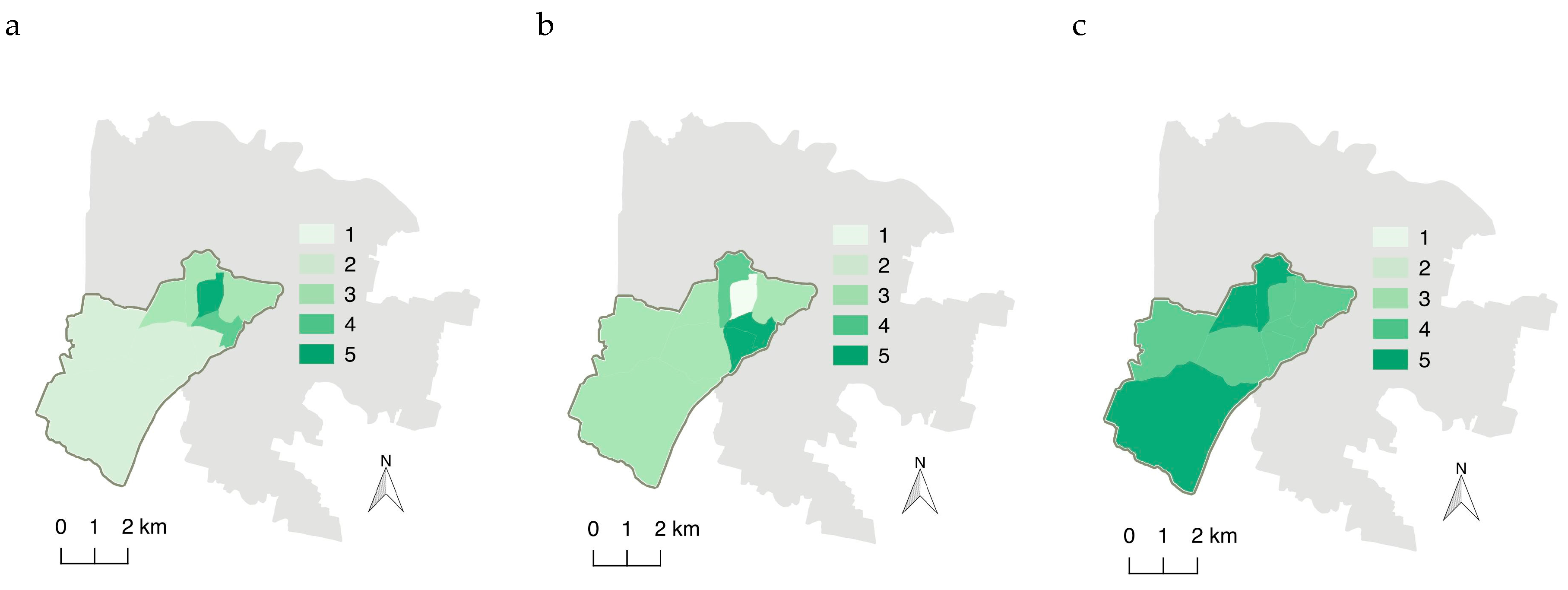
For our case study area, indicators linked to green spaces demonstrate a scarcity of the resource in the historical city center (Figure 1). Land units with higher values for these indicators are in an intermediate location between the city center and outer areas. Instead, accessibility (Figure 1c) of green spaces seem to be similar in many land units except for the city center and intermediate residential areas.
Although indicators focusing on tree density give a more heterogeneous picture (Figure 2), the center stands out for low values when the density is related to residents. Furthermore, a high density of street trees does not necessarily indicate a high density of green spaces trees in the same urban unit.
Interestingly, indicators linked to species diversity are extremely heterogeneous (Figure 3). This suggests that different actions should be taken in the various land units to increase tree species diversity. In general, although equitability values can be considered relatively high (Figure 3c), a higher species heterogeneity would be suggested in those urban units with a low number of species.
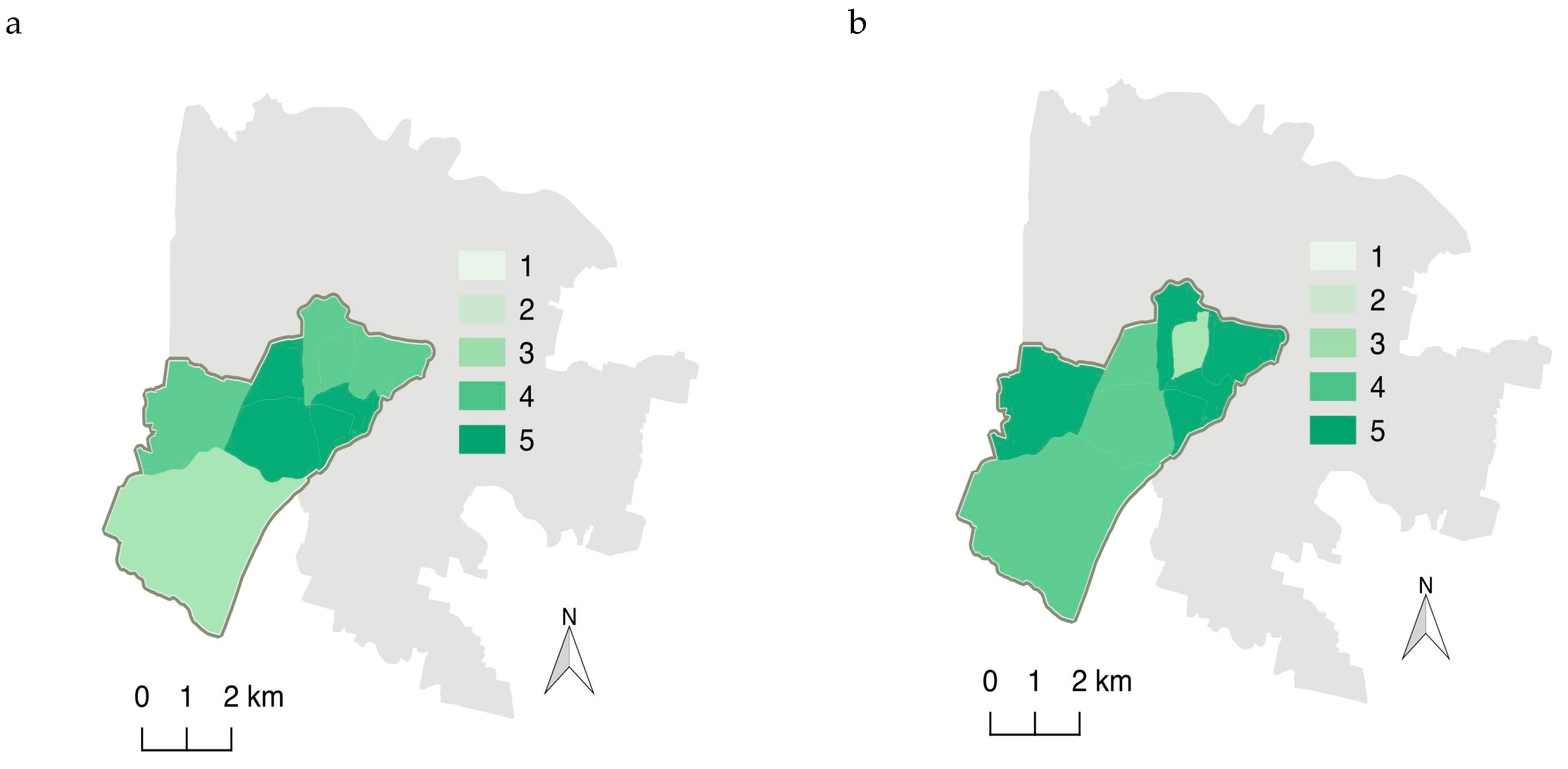
DBH distribution seems most distant from the “ideal” in proximity to the historical city center but also in the rural part (Figure 4a). Interestingly, some areas have a distribution resembling the ideal one. The areas with a low value indicate urgent needs in terms of increasing at least one of the three DBH classes, and decreasing the excessive ones. Overlapping with the main DBH distribution deficiency (Table 4), it is evident that not all areas lack trees for the same DBH class. Furthermore, just less than half the urban units do not have major distribution issues.
Canopy cover, referring not only to municipal trees, shows a similar trend, with low values in the center and higher values in some intermediate residential and outer areas (Figure 4b).
4. Discussion
The benefits derived from trees and forests in urban landscapes (for a list of services and disservices in [4,55]), such as mitigating pollution [56], and promoting human health and wellbeing [57], as well as from green spaces in general [58,59], are tightly linked to planning [11]. The set of indicators reported in this study help urban planners and managers to assess urban units in terms of quality of the available green spaces and their future design. Indeed, they can form the backbone for potential evaluations of the performance of different land units and set benchmarks for a green infrastructure management plan. Furthermore, the applied indicators guarantee assessing against a healthy and sustainable green infrastructure.
4.1. Prospects on Future Monitoring and Management in the Basso Isonzo Case Study
The set of indicators helped in assessing and comparing the current performance between different land units that represent a gradient from the historical town center to the urban–rural interface in the Basso Isonzo area of the city of Padua. Interestingly, considered singly and in an integrated approach, the values of the indicators highlighted important monitoring, management, and planning aspects.
Green areas’ availability is low for a number of land units. Similar or even lower values have been recorded for public green space in many Italian cities [24]. Although increasing of municipal green space, as with the establishment of new parks, through appropriate planning is possible in the outer areas, in the city center this is unlikely or more complicated because of a lack of space. Nevertheless, in the city center planning could focus on favoring green roofs and living walls. In fact, only two urban units, of which one is the city center, have less than 9–11 m2/inh. of green space available, a value suggested to secure the quality of life in cities [17]. Furthermore, some units have relatively high values of green area per capita, exceeding the common range of values (10–30 m2/inh.) recorded in Italian cities [24]. However, accessibility is relatively heterogeneous between urban units as also recorded in other Italian cities [28]. Our results highlight that only a few units have an urgent need to increase accessibility of green spaces.
Interestingly, although canopy cover varied between urban units, some have relatively high cover levels, in contrast with what is commonly reported for cities of European Mediterranean countries [18]. In fact, five out of nine urban units have a canopy cover between 25% and 30%; targets proposed for many cities [19,60]. This shows the importance that private trees have within the analyzed area and indicates that tree canopy should be increased in specific areas of the city.
Specific management needs can be differentiated with areas needing new planting while others need more mature and large trees. However, interestingly, there are some areas where the current proportion should be maintained or needs minor management action. The planting of new trees could be difficult because of space constraints and could lead to additional unbalanced age and DBH distributions that should be managed with an appropriate tree renovation program. Research in other cities has already shown that current tree age distribution is not overlapping with the “ideal” target [61]. Indeed, in some areas of the city this could be achieved by both additional planting but also through a reduction in the number of large trees. New tree planting would be possible in the rural interface area; for example, with the establishment of new hedgerows formed by trees, and with different structures, that in turn will have important implications on biodiversity and the provision of several ecosystem services [62,63].
4.2. Simple Indicators for Sustainable Urban Greening
The primary focus on public areas and landscape elements managed by the city council, as in this case study, is valuable as it could indicate applicable strategies to further develop cities’ green infrastructure. The focus on public areas and trees is linked to their direct relationship with urban planning and management. These can have strong implications on private areas, human health and wellbeing and the city’s wealth; for example, house values were found to decrease with increasing distance from public green spaces [64]. However, by including indicators not linked to land ownership, that is, tree cover, the overall evaluation also takes into account green spaces in private ownership.
Up to now, research has not focused on identifying and applying indicators linked to different urban green infrastructure elements over different land units within one city. A number of studies focused on using indicators and understanding the management and planning priorities for specific urban green spaces [54]. Furthermore, single simple indicators have often been used at the city or town scale. The application of these indicators can therefore be extended to other cities. In fact, most of the indicators are commonly suggested and can be obtained with open source tools with no need for particular expertise to run and use them, as is the case for canopy cover with i-Tree Canopy tool [65].
The inclusion of different indicators that are related to tree cover, age, and species composition enabled the urban forest provision, structure, and quality to be taken into account [44]. The applied indicators have been linked to cities’ sustainability and represent economic, social and environmental dimensions [23]. Their consideration can therefore lead to advances towards a more sustainable city. Indeed, data on trees and green spaces are crucial to understanding the ecological performance of the urban environment [66].
An added value is represented by the consideration of the main types of green infrastructure through specific indicators. For example, indicators refer to street trees and trees in green spaces separately. Therefore, the inclusion of these different indicators gives a broad view but also enables the different use and management needs to be considered [67]. This heterogeneous character, that is also important from an assessment and monitoring perspective, can better represent the variety of urban green space types. Furthermore, this study takes into consideration the call for greater attention to tree diversity in planning and management of urban areas [68] as evident from the number of indicators linked to biodiversity.
The complex social–ecological interaction is considered through an accessibility indicator that can be of extreme importance to improve human health and wellbeing [18] and that is the basis for equity assessments. While, from our study is possible to understand which are the areas that would need more available green spaces, equity was not assessed and could be of relevance for future planning. Furthermore, the use of accessibility in our study is especially important in ageing areas, as is occurring in many European cities, as nearby and easy to walk green spaces have a positive effect on longevity of senior citizens [69]. In addition, several indicators take population into consideration, an important aspect in view of the possible ecosystem services provision.
4.3. Planning and Management Implications
Our approach can contribute to effective urban planning as the applied green space indicators are related to size, such as the area and density related indicators, and refer to spatial allocation, such as urban units within a city [25]. The focus on public places and in particular on those managed by the city council, strengthens the link between the use of these indicators to suggest management and planning actions. The need for different management efforts can be derived from the value of the indicators. Indeed, for this reason and due to availability, much of the research has focused on municipal green spaces [53,70]. Furthermore, monitoring through these indicators will enable understanding whether specific targets are met and, in the absence of these targets, to identify the main trends over time, an important aspect for both planning and management.
Aiming towards a more biodiverse urban forest is commonly pinpointed as a target. The different indicators enabled diversity and heterogeneity based on tree species to be assessed. However, environmental factors can constrain the number of species that could be part of the urban forest [47]. The calculation of these indicators can also be extended to shrubs and herbaceous species when such data are available.
The use of an indicator related to DBH distribution gives an indication on population stability and replacement and removal requirements. Age information should be preferred, but is usually less available in city tree inventories and rarely measured in urban trees. Nevertheless, age distribution can be generally inferred from DBH, in particular for open-grown trees [52]. Furthermore, the dimension of DBH classes limits the precision of possible indications, as in the case of our study; therefore, precise measurements should be preferred to assigning trees directly to classes. Indeed, it is possible to set targets for an ideal distribution, based on well-known values found in the literature but also more adapted to local conditions. Finally the approach can be the basis and would benefit from an additional analysis, possibly based on a set of indicators, to evaluate and identify suitable places for planting and establishing green areas [71].
Planning needs to take into consideration ecosystem services provision of these areas. In addition to the roles of different types of green spaces in their provision, the heterogeneous distribution of the indicator values may play an important role. Furthermore, certain services may be more important for some urban units. For example, aesthetic services would be more relevant in the city center; planning should therefore take specific indicators into account, such as those related to species richness. Furthermore, temporal changes will occur regardless of improvements made to achieve specific indicator values.
4.4. Limitations
Even though this set of indicators has many positive aspects as highlighted, some limitations are worth mentioning. The land unit of reference may not be suitable for all urban areas and this would depend on the spatial scale of the data available but also on the planning organization of the cities. Sensitive data (e.g., on residents) cannot be handled without consent and this limits the array of indicators but also how they can be calculated and presented, with implications on precision. For example, network analysis may give a more reliable picture of accessibility to residents but individual data on residents are required together with relatively complex calculations [41]. Integrating data on the main green infrastructure elements can derive further and more focused indicators. For example, different types of roads could have different densities of trees and could be assessed separately, or the additional use of national (or regional) species lists could allow differentiation between native and non-native species. Furthermore, data on different elements (e.g., population, trees) are updated periodically but not at the same time.
The urban tree canopy is a useful indicator to assess existing canopy and compare it with benchmark values and planning goals. Nevertheless, urban tree canopy goals are most meaningful when tied to specific desired or possible outcomes. In most cases it is not useful to set canopy goals as an absolute percentage value on the city area, but rather as a percentage of a maximum urban tree canopy value that considers space available for trees and other constraints. Indeed, a number of methods have been proposed to identify existing, possible, potential, preferable, and relative urban tree canopy [72,73,74].
The type of data is a limitation but can give important indications for future assessments and monitoring. The low number of currently available DBH classes, with a wide range of values, reduces the possibility of gaining a good understanding of the distribution. The current survey protocol should thus be adapted to record DBH classes with a narrower range of possible diameter values. Moreover, remote sensing tools could be used to integrate the existing database and also to assess a number of the proposed indicators on private land.
Finally, this study purposely applied a number of indicators that can suggest possible planning and management. However, future studies should investigate the possibility of producing a systemic indicator to evaluate performance [75]. With such an approach it is possible to perform a sensitivity and uncertainty analyses and the most important indicators could be identified. Furthermore, current policies call for an inclusion of stakeholders’ preferences and values. Stakeholders’ perspective could be included by assigning weights to the different indicators that represent their preferences.
5. Conclusions
Many costs and benefits, as well as the complex social, economic and ecological interactions, enter into play when drawing up appropriate urban designs and plans [11], so indicators may be a valid resource for making decisions. The proposed approach and the applied indicators are simple to collect, analyze, and convey information. The set of indicators covers relevant social, economic, and ecological conditions related to green spaces including urban forests. They provide insights into specific management actions and can give important planning indications that would be required for a sustainable urban green infrastructure. The proposed indicators can therefore be used as a simple tool to guide decision making with the aim of enhancing green spaces.
Author Contributions
Conceptualization, T.C. and P.S.; methodology, T.C. and P.S.; formal analysis, T.C. and P.S.; writing—original draft preparation, T.C.; writing—review and editing, P.S., T.S. and V.E.C.; visualization, T.C. and V.E.C.; funding acquisition, P.S.
Funding
This research was partially funded by research project “Sviluppo di indicatori quantitativi e qualitativi relativi all’infrastruttura verde della città di Padova nell’ambito del progetto europeo UGB” financed by Comune di Padova, Settore Ambiente e Territorio.
Acknowledgments
We are grateful to Fiorenza Colombo, Daniela Luise and Maurizio Minicuci for sharing data regarding green spaces in Padua and to Viviana Ferrario and Chrysafina Geronta for sharing views on management and planning of the Basso Isonzo area. We thank Alison M. N. Garside for language revision.
Conflicts of Interest
The authors declare no conflict of interest.
References
- Tzoulas, K.; Korpela, K.; Venn, S.; Yli-Pelkonen, V.; Kaźmierczak, A.; Niemela, J.; James, P. Promoting ecosystem and human health in urban areas using green infrastructure: A literature review. Landsc. Urban Plan. 2007, 81, 167–178. [Google Scholar] [CrossRef] [Green Version]
- Niemelä, J.; Saarela, S.-R.; Söderman, T.; Kopperoinen, L.; Yli-Pelkonen, V.; Väre, S.; Kotze, D.J. Using the ecosystem services approach for better planning and conservation of urban green spaces: A Finland case study. Biodivers. Conserv. 2010, 19, 3225–3243. [Google Scholar] [CrossRef]
- Haq, S.M.A. Urban green spaces and an integrative approach to sustainable environment. J. Environ. Prot. 2011, 2, 601–608. [Google Scholar] [CrossRef] [Green Version]
- Dobbs, C.; Escobedo, F.J.; Zipperer, W.C. A framework for developing urban forest ecosystem services and goods indicators. Landsc. Urban Plan. 2011, 99, 196–206. [Google Scholar] [CrossRef]
- Konijnendijk, C.C.; Ricard, R.M.; Kenney, A.; Randrup, T.B. Defining urban forestry—A comparative perspective of North America and Europe. Urban For. Urban Green. 2006, 4, 93–103. [Google Scholar] [CrossRef] [Green Version]
- Taylor, L.; Hochuli, D.F. Defining greenspace: Multiple uses across multiple disciplines. Landsc. Urban Plan. 2017, 158, 25–38. [Google Scholar] [CrossRef] [Green Version]
- Cvejić, R.; Eler, K.; Pintar, M.; Železnikar, Š.; Haase, D.; Kabisch, N.; Strohbach, M. A Typology of Urban Green Spaces, Ecosystem Services Provisioning Services and Demands. Report: D3.1, GREEN SURGE Project (2013–2017);. 2015. Available online: https://greensurge.eu/working-packages/wp3/files/D3.1_Typology_of_urban_green_spaces_1_.pdf/D3.1_Typology_of_urban_green_spaces_v2_.pdf (accessed on 10 December 2019).
- Clark, J.R.; Matheny, N.P.; Cross, G.; Wake, V. A model of urban forest sustainability. J. Arboric. 1997, 23, 17–30. [Google Scholar]
- Thorén, K.H. “The green poster” A method to evaluate the sustainability of the urban green structure. Environ. Impact Assess. Rev. 2000, 20, 359–371. [Google Scholar] [CrossRef]
- Juhola, S. Planning for a green city: The Green Factor tool. Urban For. Urban Green. 2018, 34, 254–258. [Google Scholar] [CrossRef]
- Nowak, D.J.; Dwyer, J.F. Understanding the benefits and costs of urban forest ecosystems. In Urban and Community Forestry in the Northeast; Kuser, J.E., Ed.; Springer: New York, NY, USA, 2007; pp. 25–46. [Google Scholar]
- Randrup, T.B.; Persson, B. Public green spaces in the nordic countries: Development of a new strategic management regime. Urban For. Urban Green. 2009, 8, 31–40. [Google Scholar] [CrossRef]
- Jansson, M.; Lindgren, T. A review of the concept ‘management’ in relation to urban landscapes and green spaces: Toward a holistic understanding. Urban For. Urban Green. 2012, 11, 139–145. [Google Scholar] [CrossRef]
- Kenney, W.A.; van Wassenaer, P.J.E.; Satel, A.L. Criteria and indicators for strategic urban forest planning and management. Arboric. Urban For. 2011, 37, 108–117. [Google Scholar]
- Schipperijn, J.; Pillmann, W.; Tyrväinen, L.; Mäkinen, K.; O’Sullivan, R. Information for urban forest planning and management. In Urban Forests and Trees: A Reference Book; Konijnendijk, C., Nilsson, K., Randrup, T., Schipperijn, J., Eds.; Springer: Berlin/Heidelberg, Germany, 2005; pp. 399–417. [Google Scholar]
- Badach, J.; Raszeja, E. Developing a framework for the implementation of landscape and greenspace indicators in sustainable urban planning. Waterfront landscape management: Case studies in Gdańsk, Poznań and Bristol. Sustainability 2019, 11, 2291. [Google Scholar] [CrossRef] [Green Version]
- De la Barrera, F.; Reyes-Paecke, S.; Banzhaf, E. Indicators for green spaces in contrasting urban settings. Ecol. Indic. 2016, 62, 212–219. [Google Scholar] [CrossRef]
- Kabisch, N.; Strohbach, M.; Haase, D.; Kronenberg, J. Urban green space availability in European cities. Ecol. Indic. 2016, 70, 586–596. [Google Scholar] [CrossRef]
- Barron, S.; Sheppard, S.R.J.; Condon, P.M. Urban forest indicators for planning and designing future forests. Forests 2016, 7, 208. [Google Scholar] [CrossRef]
- Badiu, D.L.; Iojă, C.I.; Pătroescu, M.; Breuste, J.; Artmann, M.; Niță, M.R.; Grădinaru, S.R.; Hossu, C.A.; Onose, D.A. Is urban green space per capita a valuable target to achieve cities’ sustainability goals? Romania as a case study. Ecol. Indic. 2016, 70, 53–66. [Google Scholar] [CrossRef]
- Chan, C.-S.; Si, F.H.; Marafa, L.M. Indicator development for sustainable urban park management in Hong Kong. Urban For. Urban Green. 2018, 31, 1–14. [Google Scholar] [CrossRef]
- Östberg, J.; Delshammar, T.; Wiström, B.; Nielsen, A.B. Grading of parameters for urban tree inventories by city officials, arborists, and academics using the Delphi method. Environ. Manag. 2013, 51, 694–708. [Google Scholar] [CrossRef] [Green Version]
- Lee, Y.-J.; Huang, C.-M. Sustainability index for Taipei. Environ. Impact Assess. Rev. 2007, 27, 505–521. [Google Scholar] [CrossRef]
- Chiesura, A.; Mirabile, M.; Adamo, D.; Laganà, A. Il verde pubblico. In Qualità dell’Ambiente Urbano; Rapporto (2017), Stato dell’Ambiente 74/17; ISPRA: Roma, Italy, 2017; Volume XIII, pp. 127–139. [Google Scholar]
- Valente, D.; Pasimeni, M.R.; Petrosillo, I. The role of green infrastructures in Italian cities by linking natural and social capital. Ecol. Indic. 2020, 108, 105694. [Google Scholar] [CrossRef]
- Steenberg, J.W.N.; Duinker, P.N.; Nitoslawski, S.A. Ecosystem-based management revisited: Updating the concepts for urban forests. Landsc. Urban Plan. 2019, 186, 24–35. [Google Scholar] [CrossRef]
- Heynen, N.C.; Lindsey, G. Correlates of urban forest canopy cover: Implications for local public works. Public Work. Manag. Policy 2003, 8, 33–47. [Google Scholar] [CrossRef]
- Quatrini, V.; Tomao, A.; Corona, P.; Ferrari, B.; Masini, E.; Agrimi, M. Is new always better than old? Accessibility and usability of the urban green areas of the municipality of Rome. Urban For. Urban Green. 2019, 37, 126–134. [Google Scholar] [CrossRef]
- Ekkel, E.D.; de Vries, S. Nearby green space and human health: Evaluating accessibility metrics. Landsc. Urban Plan. 2017, 157, 214–220. [Google Scholar] [CrossRef]
- Dai, D. Racial/ethnic and socioeconomic disparities in urban green space accessibility: Where to intervene? Landsc. Urban Plan. 2011, 102, 234–244. [Google Scholar] [CrossRef]
- Wolch, J.R.; Byrne, J.; Newell, J.P. Urban green space, public health, and environmental justice: The challenge of making cities ‘just green enough’. Landsc. Urban Plan. 2014, 125, 234–244. [Google Scholar] [CrossRef] [Green Version]
- Maes, J.; Zulian, G.; Thijssen, M.; Castell, C.; Baro, F.; Ferreira, A.; Melo, J.; Garret, C.P.; David, N.; Alzetta, C.; et al. Mapping and Assessment of Ecosystems and Their Services: Urban Ecosystems 4th Report, Final May 2016; Publication Office of the European Union: Luxembourg, 2016. [Google Scholar]
- Geronta, C.; Ferrario, V. Creation of a preliminary database fro monitoring and evaluating the tranformations of the peri-urban landscape of Padua (Italy). Gi_Forum 2018, 6, 117–125. [Google Scholar] [CrossRef]
- Sitzia, T.; Campagnaro, T.; Weir, R.G. Novel woodland patches in a small historical mediterranean city: Padova, northern Italy. Urban Ecosyst. 2016, 19, 475–487. [Google Scholar] [CrossRef]
- Segnestam, L. Indicators of Environment and Sustainable Development. Theories and Practical Experience; Environmental Economics Series Paper no. 89; The World Bank Environment Department: Washington, DC, USA, 2002; p. 66. [Google Scholar]
- Nowak, D.J. Understanding the structure of urban forests. J. For. 1994, 92, 36–41. [Google Scholar]
- World Health Organization. Urban Green Spaces and Health; WHO Regional Office for Europe: Copenhagen, Denmark, 2016. [Google Scholar]
- Ottitsch, A.; Krott, M. Urban forest policy and planning. In Urban Forests and Trees: A Reference Book; Konijnendijk, C., Nilsson, K., Randrup, T., Schipperijn, J., Eds.; Springer: Berlin/Heidelberg, Germany, 2005; pp. 117–148. [Google Scholar]
- Mitchell, R.; Popham, F. Greenspace, urbanity and health: Relationships in England. J. Epidemiol. Community Health 2007, 61, 681–683. [Google Scholar] [CrossRef] [PubMed] [Green Version]
- Grunewald, K.; Richter, B.; Meinel, G.; Herold, H.; Syrbe, R.-U. Proposal of indicators regarding the provision and accessibility of green spaces for assessing the ecosystem service “recreation in the city” in Germany. Int. J. Biodivers. Sci. Ecosyst. Serv. Manag. 2017, 13, 26–39. [Google Scholar] [CrossRef] [Green Version]
- Van den Bosch, M.A.; Mudu, P.; Uscila, V.; Barrdahl, M.; Kulinkina, A.; Staatsen, B.; Swart, W.; Kruize, H.; Zurlyte, I.; Egorov, A.I. Development of an urban green space indicator and the public health rationale. Scand. J. Public Health 2016, 44, 159–167. [Google Scholar] [CrossRef] [PubMed]
- Legambiente. Ecosistema Urbano. Rapporto Sulle Performance Ambientali delle Città 2017; Legambiente: Roma, Italy, 2017. [Google Scholar]
- Pauleit, S.; Jones, N.; Nyhuus, S.; Pirnat, J.; Salbitano, F. Urban forest resources in European cities. In Urban Forests and Trees: A Reference Book; Konijnendijk, C., Nilsson, K., Randrup, T., Schipperijn, J., Eds.; Springer: Berlin/Heidelberg, Germany, 2005; pp. 49–80. [Google Scholar]
- Taylor, M.S.; Wheeler, B.W.; White, M.P.; Economou, T.; Osborne, N.J. Research note: Urban street tree density and antidepressant prescription rates—A cross-sectional study in London, UK. Landsc. Urban Plan. 2015, 136, 174–179. [Google Scholar] [CrossRef]
- Schroeder, H.W.; Green, T.L. Public preference for tree density in municipal parks. J. Arboric. 1985, 11, 272–277. [Google Scholar]
- Sjöman, H.; Östberg, J.; Bühler, O. Diversity and distribution of the urban tree population in ten major Nordic cities. Urban For. Urban Green. 2012, 11, 31–39. [Google Scholar] [CrossRef] [Green Version]
- Alvey, A.A. Promoting and preserving biodiversity in the urban forest. Urban For. Urban Green. 2006, 5, 195–201. [Google Scholar] [CrossRef]
- Barker, P.A. Ordinance control of street trees. J. Arboric. 1975, 1, 212–216. [Google Scholar]
- Pielou, E.C. The measurement of diversity in different types of biological collections. J. Theor. Biol. 1966, 13, 131–144. [Google Scholar] [CrossRef]
- McPherson, G.E.; Nowak, D.J.; Heisler, G.; Grimmond, S.; Souch, C.; Grant, R.; Rowntree, R. Quantifying urban forest structure, function, and value: The Chicago urban forest climate project. Urban Ecosyst. 1997, 1, 49–61. [Google Scholar] [CrossRef]
- Richards, N.A. Diversity and stability in a street tree population. Urban Ecol. 1983, 7, 159–171. [Google Scholar] [CrossRef]
- North, E.A.; D’Amato, A.W.; Russell, M.B. Performance metrics for street and park trees in urban forests. J. For. 2018, 116, 547–554. [Google Scholar] [CrossRef] [Green Version]
- Millward, A.A.; Sabir, S. Structure of a forested urban park: Implications for strategic management. J. Environ. Manag. 2010, 91, 2215–2224. [Google Scholar] [CrossRef] [PubMed]
- USDA Forest Service. I-Tree Canopy Technical Notes. 2011. Available online: https://canopy.itreetools.org/resources/iTree_Canopy_Methodology.pdf (accessed on 10 December 2019).
- Dobbs, C.; Kendal, D.; Nitschke, C.R. Multiple ecosystem services and disservices of the urban forest establishing their connections with landscape structure and sociodemographics. Ecol. Indic. 2014, 43, 44–55. [Google Scholar] [CrossRef]
- Escobedo, F.J.; Kroeger, T.; Wagner, J.E. Urban forests and pollution mitigation: Analyzing ecosystem services and disservices. Environ. Pollut. 2011, 159, 2078–2087. [Google Scholar] [CrossRef]
- Carrus, G.; Dadvand, P.; Sanesi, G. The role and value of urban forests and areen infrastructure in promoting human health and wellbeing. In The Urban Forest: Cultivating Green Infrastructure for People and the Environment; Pearlmutter, D., Calfapietra, C., Samson, R., O’Brien, L., Krajter Ostoić, S., Sanesi, G., del Amo, R.A., Eds.; Springer International Publishing: Cham, Switzerland, 2017; pp. 217–230. [Google Scholar]
- Swanwick, C.; Dunnett, N.; Woolley, H. Nature, role and value of green space in towns and cities: An overview. Built Environ. 2003, 29, 94–106. [Google Scholar] [CrossRef]
- Kabisch, N. Ecosystem service implementation and governance challenges in urban green space planning—The case of Berlin, Germany. Land Use Policy 2015, 42, 557–567. [Google Scholar] [CrossRef]
- Doick, K.J.; Davies, H.J.; Moss, J.; Coventry, R.; Handley, P.; Rogers, K.; Simpkin, P. The canopy cover of England’s towns and cities: Baselining and setting targets to improve human health and well-being. Presented at the Trees, People and the Built Environment III, International Urban Trees Research Conference, University of Birmingham, Birmingham, UK, 5–6 April 2017. [Google Scholar]
- Maco, S.E.; McPherson, G.E. Assessing canopy cover over streets and sidewalks in street tree populations. J. Arboric. 2002, 28, 270–276. [Google Scholar]
- Sitzia, T. Hedgerows as corridors for woodland plants: A test on the Po Plain, northern Italy. Plant Ecol. 2007, 188, 235–252. [Google Scholar] [CrossRef]
- Sitzia, T.; Pizzeghello, D.; Dainese, M.; Ertani, A.; Carletti, P.; Semenzato, P.; Nardi, S.; Cattaneo, D. Topsoil organic matter properties in contrasted hedgerow vegetation types. Plant Soil 2014, 383, 337–348. [Google Scholar] [CrossRef]
- Morancho, A.B. A hedonic valuation of urban green areas. Landsc. Urban Plan. 2003, 66, 35–41. [Google Scholar] [CrossRef]
- Parmehr, E.G.; Amati, M.; Taylor, E.J.; Livesley, S.J. Estimation of urban tree canopy cover using random point sampling and remote sensing methods. Urban For. Urban Green. 2016, 20, 160–171. [Google Scholar] [CrossRef]
- Whitford, V.; Ennos, A.R.; Handley, J.F. “City form and natural process”—Indicators for the ecological performance of urban areas and their application to Merseyside, UK. Landsc. Urban Plan. 2001, 57, 91–103. [Google Scholar] [CrossRef]
- Pregitzer, C.; Ashton, M.S.; Charlop-Powers, S.; D’Amato, A.; Frey, B.R.; Gunther, B.; Hallett, R.A.; Pregitzer, K.S.; Woodall, C.W.; Bradford, M.A. Defining and assessing urban forests to inform management and policy. Environ. Res. Lett. 2019, 14, 085002. [Google Scholar] [CrossRef]
- Morgenroth, J.; Östberg, J.; van den Bosch, C.K.; Nielsen, A.B.; Hauer, R.; Sjöman, H.; Chen, W.; Jansson, M. Urban tree diversity—Taking stock and looking ahead. Urban For. Urban Green. 2016, 15, 1–5. [Google Scholar] [CrossRef] [Green Version]
- Takano, T.; Nakamura, K.; Watanabe, M. Urban residential environments and senior citizens’ longevity in megacity areas: The importance of walkable green spaces. J. Epidemiol. Community Health 2002, 56, 913–918. [Google Scholar] [CrossRef] [Green Version]
- McPherson, G.E.; Simpson, J.R.; Peper, P.J.; Maco, S.E.; Xiao, Q. Municipal forest benefits and costs in five U.S. cities. J. For. 2005, 103, 411–416. [Google Scholar]
- Li, Z.; Fan, Z.; Shen, S. Urban green space suitability evaluation based on the AHP-CV combined weight method: A case study of Fuping county, China. Sustainability 2018, 10, 2656. [Google Scholar] [CrossRef] [Green Version]
- Raciti, S.; Galvin, M.F.; Grove, J.M.; O’Neil-Dunne, J.P.M.; Todd, A.; Clagett, S. Urban Tree Canopy Goal Setting: A Guide for Chesapeake Bay Communities; United States Department of Agriculture, Forest Service, Northeastern State & Private Forestry, Chesapeake Bay Program Office: Annapolis, MD, USA, 2006.
- Mincey, S.K.; Schmitt-Harsh, M.; Thurau, R. Zoning, land use, and urban tree canopy cover: The importance of scale. Urban For. Urban Green. 2013, 12, 191–199. [Google Scholar] [CrossRef]
- Locke, D.H.; Grove, J.M.; Lu, J.W.T.; Troy, A.; O’Neil-Dunne, J.P.M.; Beck, B.D. Prioritizing preferable locations for increasing urban tree canopy in New York City. Cities Environ. 2010, 3, 4. [Google Scholar] [CrossRef]
- Servadio, J.L.; Convertino, M. Optimal information networks: Application for data-driven integrated health in populations. Sci. Adv. 2018, 4, e1701088. [Google Scholar] [CrossRef] [PubMed] [Green Version]
Figure 1.
Values for the different indicators linked to urban green spaces in the study area: (a) green area per capita; (b) percentage of green areas; (c) accessibility.
Figure 1.
Values for the different indicators linked to urban green spaces in the study area: (a) green area per capita; (b) percentage of green areas; (c) accessibility.

Figure 2.
Values for the different indicators linked to tree density: (a) density of trees on streets; (b) tree density in green spaces; (c) trees per 100 residents.
Figure 2.
Values for the different indicators linked to tree density: (a) density of trees on streets; (b) tree density in green spaces; (c) trees per 100 residents.

Figure 3.
Values for the different indicators linked to tree species diversity: (a) number of species per 100 trees; (b) number of species over 5%; (c) Pielou’s equitability.
Figure 3.
Values for the different indicators linked to tree species diversity: (a) number of species per 100 trees; (b) number of species over 5%; (c) Pielou’s equitability.

Figure 4.
(a) Results derived from comparison with the “ideal” DBH distribution. (b) Percentage of canopy cover over the entire unit.
Figure 4.
(a) Results derived from comparison with the “ideal” DBH distribution. (b) Percentage of canopy cover over the entire unit.


Table 1.
Summary of indicators with information on the reasons for their selection and related formula for their calculation.
Table 1.
Summary of indicators with information on the reasons for their selection and related formula for their calculation.
| Indicator | Code | Rationale | Equation |
|---|---|---|---|
| (1) Public green area per capita [m2/inh.] | GC | Planning (monitoring standards and goals, establishing priorities, reducing inequalities in green areas provision among land units) | |
| (2) Percentage of public green areas [%] | GP | Planning (monitoring standards and goals, reducing inequalities in green areas provision) | |
| (3) Accessibility [%] | GA | Planning (monitoring standards and goals, reducing inequalities in green areas accessibility provision among land units) | |
| (4) Trees per 100 residents * | TR | Planning and management (evaluating policies and management outcomes, reducing inequalities in ecosystem services provision) | |
| (5) Trees on streets * [trees/km] | TS | Planning (evaluating policies and management outcomes, reducing inequalities in ecosystem services provision) | |
| (6) Tree density in green spaces * [trees/ha] | TG | Planning (evaluating policies and management outcomes, reducing inequalities in ecosystem services provision) | |
| (7) Number of species per 100 trees * | TN | Planning and management (evaluating forest composition, establish a diverse tree population citywide as well as at land unit level, evaluating policies and management outcomes) | |
| (8) Number of species over 5% * | TP | Planning and management (evaluating forest composition, establish a diverse tree population citywide as well as at land unit level, evaluating policies and management outcomes) | |
| (9) Equitability * | TE | Planning and management (evaluating forest composition, establish a diverse tree population citywide as well as at land unit level, evaluating policies and management outcomes) | |
| (10) Tree DBH distribution * | TD | Management (evaluating age structure, provide for uneven aged distribution citywide as well as at land unit level, prioritizing management actions and resources, evaluating management outcomes) | |
| (11) Canopy cover [%] | CC | Planning (establishing benchmarks, reducing inequalities in ecosystem services provision, evaluating policies and management outcomes) |
* These indicators refer to municipal trees.
Table 2.
“Ideal” diameter and breast height (DBH) distribution adopted in this study.
| DBH Classes | % of Trees |
|---|---|
| 0–20 cm | 40 |
| 21–40 cm | 30 |
| >40 cm | 30 |
Table 3.
Summary of the values and their standardization per urban unit (numerical codes) recorded for the applied indicators. Abbreviated names correspondence is reported in Table 1. Units of measure are reported for specific values, whereas a standardized value is indicated with S.
Table 3.
Summary of the values and their standardization per urban unit (numerical codes) recorded for the applied indicators. Abbreviated names correspondence is reported in Table 1. Units of measure are reported for specific values, whereas a standardized value is indicated with S.
| Urban Unit | GC | GP | GA | TR | TS | TG | TN | TP | TE | TD | CC | |||||||||||
|---|---|---|---|---|---|---|---|---|---|---|---|---|---|---|---|---|---|---|---|---|---|---|
| m2/inh. | S | % | S | % | S | no. | S | No./km | S | no./ha | S | no. | S | no. | S | Eq. | S | % | S | % ± se | S | |
| 1.1 | 4 | 0.08 | 3.0 | 0.27 | 39.72 | 0.40 | 6 | 0.15 | 11 | 0.14 | 64 | 0.65 | 14 | 1.00 | 1 | 0.14 | 0.75 | 0.75 | 0.32 | 0.82 | 12.8 ± 1.5 | 0.44 |
| 1.2 | 14 | 0.34 | 8.1 | 0.72 | 55.84 | 0.56 | 15 | 0.38 | 31 | 0.40 | 48 | 0.48 | 7 | 0.49 | 5 | 0.71 | 0.80 | 0.80 | 0.37 | 0.78 | 25.7 ± 1.95 | 0.88 |
| 1.3 | 26 | 0.63 | 10.9 | 0.98 | 72.23 | 0.72 | 22 | 0.56 | 20 | 0.25 | 57 | 0.58 | 7 | 0.49 | 4 | 0.57 | 0.79 | 0.79 | 0.37 | 0.78 | 29.3 ± 2.04 | 1.00 |
| 1.4 | 18 | 0.42 | 7.8 | 0.70 | 97.00 | 0.97 | 16 | 0.41 | 31 | 0.40 | 31 | 0.31 | 9 | 0.65 | 6 | 0.86 | 0.78 | 0.78 | 0.15 | 0.95 | 25.1 ± 1.94 | 0.86 |
| 1.5 | 21 | 0.49 | 11.2 | 1.00 | 89.78 | 0.90 | 39 | 1.00 | 78 | 1.00 | 62 | 0.62 | 5 | 0.39 | 7 | 1.00 | 0.75 | 0.75 | 0.08 | 1.00 | 25.2 ± 1.94 | 0.86 |
| 2 | 42 | 1.00 | 11.2 | 1.00 | 82.86 | 0.83 | 23 | 0.59 | 23 | 0.29 | 37 | 0.38 | 5 | 0.40 | 4 | 0.57 | 0.77 | 0.77 | 0.12 | 0.98 | 20.0 ± 1.79 | 0.68 |
| 3 | 7 | 0.16 | 4.2 | 0.37 | 65.64 | 0.66 | 17 | 0.44 | 36 | 0.46 | 99 | 1.00 | 7 | 0.52 | 3 | 0.43 | 0.80 | 0.80 | 0.26 | 0.86 | 19.6 ± 1.77 | 0.67 |
| 14 | 26 | 0.62 | 3.0 | 0.27 | 75.35 | 0.75 | 21 | 0.54 | 4 | 0.05 | 69 | 0.70 | 5 | 0.34 | 4 | 0.57 | 0.81 | 0.81 | 0.53 | 0.66 | 19.5 ± 1.77 | 0.67 |
| 15 | 30 | 0.72 | 6.1 | 0.55 | 74.09 | 0.74 | 22 | 0.56 | 13 | 0.17 | 50 | 0.51 | 5 | 0.37 | 4 | 0.57 | 0.74 | 0.74 | 0.28 | 0.85 | 26.1 ± 1.96 | 0.89 |
Table 4.
Main DBH class deficiencies compared to the ideal distribution for the different urban units.
Table 4.
Main DBH class deficiencies compared to the ideal distribution for the different urban units.
| Urban Unit | Main DBH Distribution Deficiencies |
|---|---|
| 1.1 | Lack of the 21–40 cm class |
| 1.2 | Lack of the 0–20 cm class |
| 1.3 | Lack of the 0–20 cm class |
| 1.4 | / |
| 1.5 | / |
| 2 | / |
| 3 | / |
| 14 | Lack of the 21–40 cm class |
| 15 | Lack of the >40 cm class |
© 2019 by the authors. Licensee MDPI, Basel, Switzerland. This article is an open access article distributed under the terms and conditions of the Creative Commons Attribution (CC BY) license (http://creativecommons.org/licenses/by/4.0/).
Share and Cite
MDPI and ACS Style
Campagnaro, T.; Sitzia, T.; Cambria, V.E.; Semenzato, P. Indicators for the Planning and Management of Urban Green Spaces: A Focus on Public Areas in Padua, Italy. Sustainability 2019, 11, 7071. https://doi.org/10.3390/su11247071
AMA Style
Campagnaro T, Sitzia T, Cambria VE, Semenzato P. Indicators for the Planning and Management of Urban Green Spaces: A Focus on Public Areas in Padua, Italy. Sustainability. 2019; 11(24):7071. https://doi.org/10.3390/su11247071
Chicago/Turabian StyleCampagnaro, Thomas, Tommaso Sitzia, Vito Emanuele Cambria, and Paolo Semenzato. 2019. "Indicators for the Planning and Management of Urban Green Spaces: A Focus on Public Areas in Padua, Italy" Sustainability 11, no. 24: 7071. https://doi.org/10.3390/su11247071
Note that from the first issue of 2016, this journal uses article numbers instead of page numbers. See further details here.