Article

A Geoarchaeological Reading of the City-Overlap-City Phenomenon in the Lower Yellow River Floodplain: A Case Study of Kaifeng City, China

1
Key Research Institute of Yellow River Civilization and Sustainable Development & Collaborative Innovation Center on Yellow River Civilization jointly built by Henan Province and Ministry of Education, Henan University, Kaifeng 475001, China
2
College of Environment and Planning, Henan University, Kaifeng 475004, China
3
Department of Civil Engineering, Lushan College of Guangxi University of Science and Technology, Liuzhou 545616, Guangxi, China
*
Authors to whom correspondence should be addressed.
Sustainability 2019, 11(4), 1029; https://doi.org/10.3390/su11041029
Submission received: 27 December 2018 / Revised: 11 February 2019 / Accepted: 13 February 2019 / Published: 16 February 2019
(This article belongs to the Special Issue Natural Sciences in Archaeology and Cultural Heritage)

Abstract

:
The unique urban form on the ground and the “city overlap city” phenomenon occurring underground at Kaifeng city, on the Yellow River floodplain, is investigated. Archaeological data and historical geographical analysis were used to study the form of surface remains. Primary data were collected from four 25 m long drill cores which were obtained from different locations at Kaifeng city and the sedimentary cycles were quantitatively divided-out and dated. The results show that the evolution of Kaifeng’s surface urban form mainly occurred over four periods, the first of which was before 225 BC; the second took place between 225 BC and 956 AD; the third between 956 AD and 1219 AD; and the fourth between 1219 AD and 1907 AD. The results support the view that the city wall of today has undergone continuous reconstruction on the basis of previous city walls and thus forming the special landscape sequence of overlapped walls as a result of the 1642 AD and 1841 AD floods. The results also substantiate the “city overlap city” phenomenon at Kaifeng city where there are at least “three and a half ancient cities” located underground today, and suggests the “city overlap city” landscape is a harmonious production comprising both natural and human heritages that are of worldwide significance in terms of authenticity and integrity. Our results contribute to understanding the effects of Yellow River flooding on shaping adaptive landscapes and human beings, and suggest that Kaifeng city as well as other lower Yellow River sites become World Heritage sites.

1. Introduction

Cities are important compositions of human civilization and, arguably, the main space formations of human society. The study of cities, therefore, is of value to society, not only concerning contemporary issues but also in relation to how they developed previously. This is especially the case for cities, or rather urban sites, which have been impacted by historical natural disasters such as earthquakes, tsunamis, and floods that resulted in destruction or the disruption of urban civilization. The work of excavating and researching such urban sites through archaeological methods has, therefore, become a hot topic in academia [1,2,3,4,5]. Well known urban archaeological sites including Pompeii, Volubilis, and the archaeological ensemble of Tarraco, have become important assets of international cultural heritage, and have received much attention in western countries. Among them, Pompeii was built in the 6th century BC but was subsequently destroyed as a result of the Mount Vesuvius eruption in 79 AD, where streets and houses were buried by volcanic ash. Remarkably, these houses have been preserved relatively completely, and archaeological excavations have continued since 1748 AD, providing important information enhancing our understanding of social life, culture and the art of ancient Rome [6,7]. Consequently, the city of Pompeii has been designated as a world cultural and natural heritage site by the United Nations Educational, Scientific and Cultural Organization (UNESCO).
In China, there are also many unique urban areas, similar to “Pompeii”, forming what is known as a “city overlap city” landscape because in different historical periods, cities have been built successively in the same area under the influence of natural and social factors, and there is an obvious vertical overlapping phenomenon. Several cities including Kaifeng, Shangqiu, Xuzhou, and Xiapi, which are located in the Yellow River floodplain, characteristically exhibit this special urban landscape phenomenon which was essentially produced through flooding of the Yellow River in the historical period [8,9,10,11]. Among these cities, Kaifeng city, the only provincial city in the Yellow River floodplain, has suffered the most from Yellow River floods; for instance, it has been destroyed several times throughout history. Although these cities and their relationship to the Yellow River can be considered to be highly relevant in research on the impact of environmental change, especially concerning human coping mechanisms, research in this area has hitherto been limited to mere “landscape descriptions” and, therefore, little is known about the region’s stratigraphic characteristics. This limitation is generally regarded as being related to the fact that the floodplain in the lower reaches of the Yellow River is in an economically underdeveloped region, and consequently, the government, as well as most other sectors of society, is not sufficiently aware of the natural and human heritage intrinsic to these unique cities and the region.
Therefore, this study takes Kaifeng as a case in point, using archaeological data and historical geographical analysis to study the form of surface remains. Primary data were collected from four drill cores which were obtained from different locations at Kaifeng city. The sedimentary cycles were quantitatively divided-out and dated, and the form of Kaifeng’s underground city heritage was thus revealed, at least, from the perspective of stratigraphy. The purpose of this study is not only to explain the shape of this “city overlap city” landscape as a harmonious production, made by human beings and nature in the context of the Yellow River floods, but also, in terms of a representation of the “wisdom of the ancients” which has an important heritage value. It is also intended that this study can be used as a reference for other such studies in the Yellow River floodplain.

2. Study Area

2.1. Cities of the Lower Yellow River Floodplain
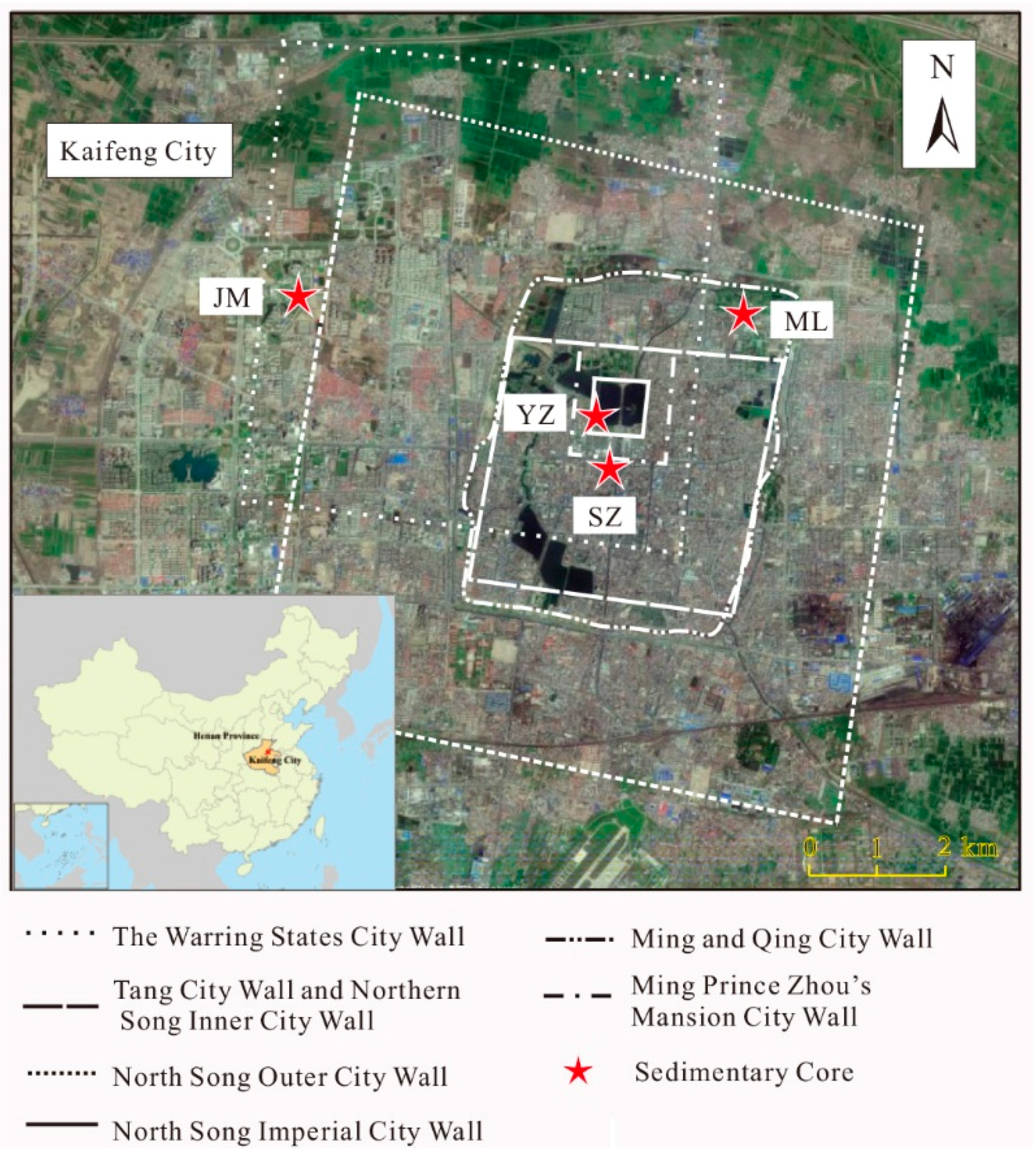
The Yellow River, known as “China’s sorrow” because of the misery caused by its periodic flooding, traverses the lower Yellow River floodplain. During the Holocene, in the lower reaches of the Yellow River, the course of its flow fluctuated frequently over the North China Plain, with flows into the Bohai Sea in the Northeast, or into the Yellow Sea in the Southeast. The area covered by the river basin, which is bounded by Tianjin to the north and Jianghuai to the south, comprises some 250,000 km2 and had a very important impact on the social and economic development of the region [12,13]. The lower Yellow River in history has been characterized as frequently shifting course with overflows leading to floods. According to records in historical documents, catastrophic levee failure occurred 1593 times and major shifts of the channel occurred 26 times during the past 3000 years [14,15,16,17,18] (Figure 1). These changes brought unimaginable catastrophes to villages, cities, and their peoples, the survival circumstances of which, thus, merits detailed study for future benefit.
Furthermore, the current status of the ancient cities in the Yellow River floodplain were divided into three categories, as shown in Table 1, depending on the location of water: 1) lakes/ponds within the city wall, 2) lakes/ponds encircling the city wall, and, 3) the old city turned into lakes (Table 1).

2.2. Kaifeng City

Kaifeng city, extending from 34°11′N to 35°01′N and 113°52′E to 115°15′E in Henan province, is situated on the southern bank of the Yellow River, about 70 km east of the provincial capital, Zhengzhou, and nearly 650 km southwest of Beijing. (What is now Kaifeng has had a number of different names. For example, it was Yiyi in the Spring and Autumn Period, Daliang in the Warring and States Period, Bianzhou in the Sui and Tang dynasties, Dongjing in the North Song dynasty, Bianjing in the Jin dynasty, Bianliang in the Yuan dynasty, and Kaifeng in the Ming and Qing dynasties.) As an ancient capital and one of the most important cities in ancient China, Kaifeng city is often referred to as “the Capital of the Eight Dynasties”. Especially in the Northern Song dynasty Kaifeng was arguably one of the most important places in the world. (The Chronology of Chinese Dynasties—the Western Zhou Dynasty (1046 BC–771 BC); the Spring and Autumn Period (770 BC–476 BC); the Warring States Period (475 BC–221 BC); the Qin dynasty (221 BC–207 BC); the Western Han dynasty (206 BC–24 AD); Sui and Tang dynasties (581 AD–907 AD); the Northern Song dynasty (960 AD–1127 AD); the Jin and Yuan dynasties (1115 AD–1368 AD); the Ming dynasty (1368 AD–1644 AD); and the Qing dynasty (1636 AD–1912 AD).), From the Yuan, Ming and Qing Dynasties to 1954 AD, Kaifeng was the provincial capital of Henan province, but this changed in 1954 AD, when the provincial capital moved westward to Zhengzhou and Kaifeng became a regional level city.
Since the third century BC at least seven floods have devastated Kaifeng city (Table 2). From the Southern Song Dynasty to the late Qing dynasty, Yellow River flooding has occurred more than 300 times near Kaifeng city, more than 10 of which besieged the city whilst six actually entered the city [23,24,25]. In addition, more than 10 of these floods entered the protection earth ramparts and besieged Kaifeng city. During 1448–1492 AD, the Yellow River traversed around Kaifeng city and separated Kaifeng from the north bank of the Yellow River. Kaifeng was subjected to frequent flooding by the Yellow River after the Jin and Yuan dynasties, and this gave rise to complex changes to its urban forms. There were seven major flood disasters, two of which, in 225 BC and 1642 AD, destroyed the whole city. In 1841, the city was inundated for about 8 months, but it was not until 1843 that the walls were reconstructed, and by this time, the urban form of Kaifeng, including the earth rampart, brick city wall and lake, became the critically important flood-adaptability landscape. More significantly, survivors rebuilt a new city on the same site after each flood, resulting in the old city buried in the cultural layers of different periods (i.e., the seven major floods), forming what has become known as the “city overlap city” landscape. Six Kaifeng cities now lie buried under silt with the oldest “fossil” city buried 10 m underground [26]. Nowadays, the flood disasters of the past are almost totally forgotten, but the suspended river landscape, low city wall, the huge lake in the city together with the “city overlap city” landscape significantly contribute to the Yellow River’s natural heritage as well as to the cultural heritage of Kaifeng city.

3. Methods

3.1. Historical Documents

China possesses a remarkable continuous written history providing information on natural and anthropogenic environmental changes. Such information includes details of floods, droughts, agricultural activities, irrigation, river management, extreme climatic events, geography, territory, population, and economic activities which can be used in detailed reconstructions of river evolution [16,17]. The literature used in this research mainly comes from the Twenty-Four Histories (such as Records of the Historian Wei Aristocratic Family), Local Chronicles (such as Xiangfu Gazetteer, Shunzhi or Guangxu edition), Local Literatures (such as Bian Wei Wet Record (Bianwei Shijin Lu) and Rumeng Record (Ru meng lu), and contemporary literatures on Kaifeng Yellow River Research (such as Annals of Kaifeng Yellow River and Kaifeng suburbs Yellow River).

3.2. Archaeological Data

Since the 1980s, the Kaifeng Cultural Relics Team and the Songcheng Archaeological Team have carried out a series of archaeological exploration works on the Kaifeng “city overlap city” site, and have made many important discoveries, most notably, the Song-Jin Palace and the Ming Prince Zhou’s Mansion (Figure 2) were found below the Longting Lake in Kaifeng city [28]. Some of their results provided clues for the establishment of the chronological framework of each core sedimentary cycles for this study (Table 3).

3.3. Stratigraphic Methods

3.3.1. Drilling Settings

The sedimentary environments in different areas of Kaifeng may display significant differences due to a range of factors including variations of levees protection, flood intensities and terrain differences, therefore, the selection of representative sites is crucial. The core sites were located cognizant that: (i) the cultural layer should embody all cultural layers from the Warring States to the present time, reflecting the overall spectacle of the “city overlap city” landscape; (ii) the inhomogeneous sedimentary environments indicate that the core sites should be located along the major flood-path trend (i.e., from northwest to southeast). Based on these premises, three sedimentary cores (designated as ML, SZ and YZ) from the urban area together with one core (JM) from the suburbs were acquired through the deployment of a drilling machine (Figure 3).

3.3.2. Sampling and Physical and Chemical Analysis

In April 2012, the four 25 m-long cores (ML, SZ, YZ and JM) were obtained through the use of a corer and large drill in open air. They were then sampled continuously, mostly at 10 cm intervals with a few sandy samples at 20 cm or 30 cm intervals. A total of 861 samples were finally acquired, comprising 213 samples from SZ, 223 from YZ, 204 from ML, and 221 from JM. All samples were subjected to laboratory investigation which included grain size analysis, black carbon (BC) content analysis, and chemical elements (Cu, Zn, Pb, Cd, Al, P, As and Hg) content analysis to classify the various sedimentary cycles (representing flood events). Grain sizes were measured using a laser diffraction particle size analyzer (Mastersizer 3000, Malvern Co. Ltd., Malvern, UK). The black carbon content was measured using a TOC analyzer (Liqui II, Elementar Co. Ltd., Hanau, Germany); whilst the content of other chemical elements were measured using an ICP-MS (Xseries-2, Thermofisher Co. Ltd., Waltham, USA).
From the samples, carbon particles, animal bones, plant seeds and residue (a part of hand-selected uncarbonized plant or a single entity fragment of plant material) as well as clay specimens were diligently selected for dating using the Accelerator Mass Spectrometry of 14C (AMS14C) in the Institute of Archaeology and Culture, Peking University. A silty sample was selected for Optical Stimulated Luminescence (OSL) dating in the Digital Environmental Archaeology Laboratory, Institute of Geography, Henan Academy of Sciences. The 14C date for this research was calibrated using the computer program OxCal v4.2.3 with the IntCal13 atmospheric calibration curve [30]. The dating results are shown in Table 4 below.

3.3.3. Sedimentary Cycle Division

The number of sedimentary cycles is a basic indicator which can be used to identify the flood frequency in alluvial strata. The approach usually adopted for the classification of sedimentary cycles based on grain size, however, is sometimes not suitable for urban strata that has been deeply disturbed by human beings. For example, after a Yellow River flood, urban reconstruction work by local residents on the recent sediments and subsequent treasure hunting activities can lead to the disturbance of the normal sequence of sedimentary cycles, which means that classification based on grain size division alone is problematic. In this study, therefore, in addition to the traditional grain size cycle, two new indicators [31,32] were selected; namely, black carbon content (black carbon cycle) and chemical element content (element cycle). During the flood receding stage, residents’ production activities and daily life resulted in accumulations of black carbon and other chemical elements (especially anthropogenic elements) near to the ground, the content of which is inevitably different from that occurring during the flood deposition stage. Based on this difference, sedimentary cycles can, therefore, be identified. With the aim of obtaining more accurate sedimentary cycles, this study comprehensively employed the cycle division results of the above three alternative indexes in order to obtain comprehensive cycles for the four cores.

4. Results

4.1. Historical Geography Development of Urban Form

The urban form used in this paper refers to the shape of the city, that is, the shape of the city formed by the enclosure of the city walls. Whether the walls of ancient cities were built or not reflects the development of cities to a certain extent. Therefore, “cities within walls” is one of the main characteristics of ancient cities in China [33]. At the same time, the change of the enclosure area represents the development scale and development level of the city [34,35]. According to the various historical developments of urban form, we can identify four main periods in the history of Kaifeng.
Before 225 BC: “City-Guo” Mode
Although the origin of Kaifeng is undocumented, it is known that a military fort existed near the southern border of the Wei kingdom between 770 BC and 476 BC. In 364 BC, Wei Huiwang moved the capital city from Anyi to Kaifeng.
From the Western Zhou to the Western Han dynasty, the capital city was named as West Cheng and East Guo by Yang Kuan [36]. It comprised a walled inner city (West Cheng) and a walled outer city (East Guo), but the inner-city layout of Kaifeng is unclear. An attempt to deduce the walls of the outer city (East Guo) was made by Wu et al. [37] (Figure 4).
The outer city wall of Kaifeng during the Warring States Period was almost square. Only two gates have been confirmed: Yi in the eastern wall and Gao in the western wall. The River Qushui crossed the northern part of the city [37,38].
In 225 BC Kaifeng was completely destroyed by General Wangben. He used the water of Honggou River to flood the entire city. Relics of the city were submerged to a depth of about 12–14 m [39].
225 BC-956 AD: “Government Office–City Wall” Mode
In this period, the city walls underwent two changes. Between 225 BC and 781 AD, the city changed very slowly and there is an absence of evidence of the lines of the city walls. Kaifeng was largely destroyed and drainage systems in the vicinity were disrupted by flood damage in 225 BC. A new city was built on the site, but it developed slowly.
Between 781 AD and 956 AD, the southern line of the city wall was extended to the south of the River Bian. There were seven gates in the wall (Figure 5).
956 AD–1219 AD: “Outer city—Inner city—Imperial city” Mode
In this period, Kaifeng became the richest city in the world, according to Zhou [40]. Reflecting its continuing status as the capital city, more projects of new constructions and city walls were undertaken, and the form of the whole city changed significantly. In 956 AD, the government began to reconstruct the city walls. There were now three city walls: around the imperial city, around the inner city and finally the outer city wall (Figure 6).
It was within the imperial city that the emperor handled state affairs. Its boundaries can be traced back to the Tang Yashu (Figure 5). Emperor Songtaizong enlarged the imperial city wall and it became 5 li (about 2340 m) in length in this period. The imperial city, which was nearly square in shape, was located north west of the inner city. It was occupied in the Jin dynasty. A new palace, Prince Zhou´s Mansion, was built in the Ming dynasty.
The inner city, which was also almost square, was the second-line defense of the city. The eastern and western lines of the inner-city wall were located beneath the city wall of the Ming and Qing Dynasties. In 1219, Emperor Xuanzong rebuilt the new southern and northern walls of the inner city and, consequently, its old southern and northern walls were subsequently destroyed to a large extent. The old southern wall was buried underground to a depth of about 8 m, whilst, the old northern wall was buried to a depth of about 8.5–9.5 m [41]. These walls are now beneath the city wall of the Ming and Qing Dynasties. The whole inner-city wall was built of brick in the Ming dynasty (Figure 7).
The outer city wall was 50 li 165 bu (about 29180 m) in length [42]. During several wars and in the post-war period, it suffered significant destruction, perhaps most notably in 1642 AD, when it was completely destroyed by flooding from the Yellow River.
1219 AD–1907 AD: “Earth Rampart—Original City Form” Mode
During the Jin and Qing Dynasties, flooding by the Yellow River had a considerable impact on the environment of Kaifeng, for instance, the outer city wall gradually disappeared as a result of flooding. An earth rampart of more or less circular form was constructed to protect the city from flooding in 1451 AD. Nevertheless, the city was flooded again in 1642 AD, and this time buried to depth of 8–10 m [39].
In 1719 AD, the Manchu city wall was rebuilt to the north of the abandoned Prince Zhou´s Mansion (Figure 8). Thereafter, the line of the brick wall remained unchanged for some 200 years, until 1907 AD.
Kaifeng’s historical geography is, in a number of respects, more complex than that of other cities in the Yellow River floodplain. The early city was flooded in 225 BC. Thereafter, a new county capital, founded on the destroyed area, developed quite slowly, and it was not until 781 AD when evidence suggests that the southern border of the city wall was extended. In the Later Zhou and Northern Song Dynasties, the imperial capital had three city walls comprising: that of the Imperial city, the Inner city and the Outer city. The Outer city wall, however, is on a larger scale than the others in all periods of wall construction. Owing to the flooding of the Yellow River, the following development of the whole city of Kaifeng was limited to within the inner city (brick city) during the Ming and Qing Dynasties. The city wall of today has undergone continuous reconstruction on the basis of previous city walls and formed the special landscape of the sequence of overlapped walls (Figure 9) because of the disastrous Yellow River floods of 1642 AD and 1841 AD.

4.2. The Underground City Form of Kaifeng Since the Warring States

From the analysis results of the grain size, black carbon, and element cycles, the four cores: JM, SZ, YZ and ML were divided-out into 15, 14, 14 and 16 comprehensive cycles respectively (Figure 10). Combined with chronological data, historical documents and archaeological data, the chronological framework of each sedimentary cycle since the Warring States Period can be established.

4.2.1. The Daliang City of the Warring States and the Honggou flood in 225 BC

This was the first time in history that Kaifeng was destroyed. From the results of this study, the ancient ground (cultural layer) of Daliang City is 10–15 m below the present ground level, which is consistent with the relevant archaeological findings [25,39]. The chasm began in 360 BC and was built in about twenty years. The Honggou diverts the water of the Yellow River from Xingyang, where it passes through Xingze and Putianze to Daliang, where it joins the Huaihe River system. At that time, the Daliang City Wall was very tall and was known as the “Seven Gaps City”. General Wangben of the Qin State failed to capture the city, and then proceeded to dig the Honggou to the west which resulted in the entrapment of Daliang City by flood water for three months. Finally, a section of the soil-based city wall to the south of the West Wall was immersed and collapsed, and the Wei State was destroyed. One hundred years after Daliang City was destroyed, Sima Qian came to Xunyi (renamed from Daliang) only to be confronted with a shattering scene, the “Ruins of Daliang” [43]. From this we can see that the damage caused by the Honggou flood to the Daliang City was very serious.

4.2.2. Dongjing City in Northern Song Dynasty and the Yellow River Flood in 1387AD

This Yellow River flood caused the sediment deposited in the drilling area of the SZ and YZ cores to be within 2 m in 1399 AD, and once again, Kaifeng city was buried as it was too late to take mitigating action. From the Qin to Yuan Dynasties, the common ancient ground (cultural layer) in Kaifeng was buried 9–13 m below the present ground level, a finding which is basically consistent with the relevant archaeological discoveries [25,39]. As Kaifeng city in the Jin and Yuan dynasties was rebuilt on the basis of Dongjing City, its magnificence and influence were far less than that of Dongjing City, and the two dynasties lasted for a relatively short time. After 12 years (1399 AD), it was silted up again, so the ancient city flooded by the Yellow River in 1387 AD could still be regarded as Dongjing City.

4.2.3. Kaifeng City in Late Ming Dynasty and the Yellow River Flood in 1642 AD

In the seven floods of Kaifeng, the flooding of the Yellow River in 1642 AD was the most serious. According to statistics, of the 370,000 people who were in Kaifeng at the time, only 30,000 survived the flood [39]. According to the results of this study, the thickness of the flood deposit is 2.3–3.8 m, the depth of the surface culture layer in Kaifeng city is between 3.5~8 m of the late Ming dynasty, and the depth of the suburban area is greater than that in the urban area. It was not until 5 years later (i.e.1647 AD) that the Yellow River breach was completely blocked. It should be pointed out that under the ground of Kaifeng city in the late Ming dynasty, there still existed the surface of the Ming dynasty which was flooded and silted by the Yellow River in 1399 AD and 1461 AD, and the thickness of sediment was 1–2 m. Whether there were ruins of Kaifeng city in these two periods underground needs further investigation. The authors believe that the two floods (i.e., 1399 AD and 1461 AD) were close to the Yellow River flood in 1387 AD, and the sedimentary thickness is not too large. On the basis of the silted ruins and broken walls, the houses were rebuilt, and the city walls and horse paths were heightened in turn. Kaifeng city may not have existed during this period, as only the cultural layer remains.

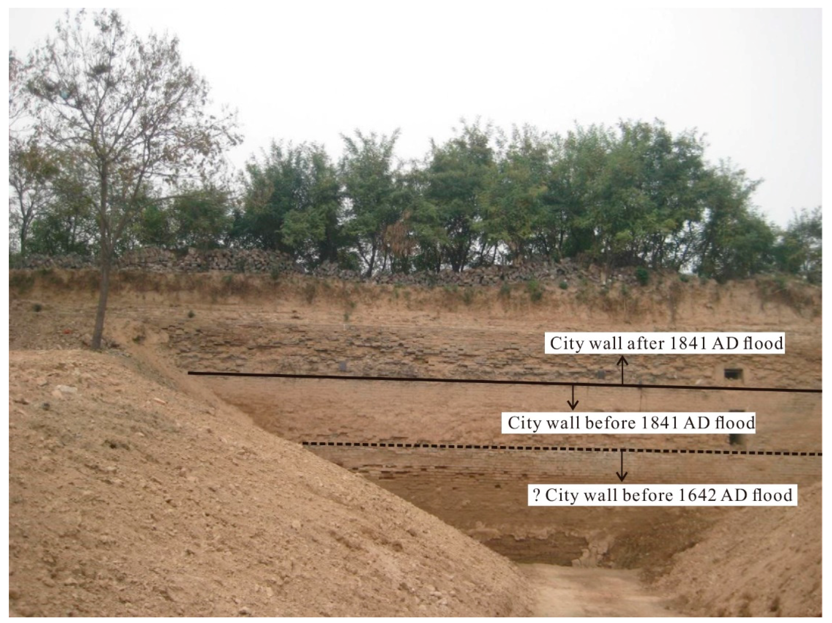
4.2.4. Kaifeng City in the Qing Dynasty and the Yellow River Flood in 1841 AD

This Yellow River flood overflowed from the South Gate with flood waters proceeding northward from east to west, converging in the north of Longting Pavilion, resulting in serious water accumulations in some parts of the city [44,45]. It was not until February 8, 1842 AD that the closure of the Yellow River’s breached embankment was completed. The flood between Kaifeng brick city and the moat and the accumulated water in the city gradually subsided, but the city was besieged by floods for eight months. This Yellow River flood did not cover the whole city, so Kaifeng city was not completely buried underground. For example, the ML core which is located in Gongyuan of Henan Province, showed no signs of deposits from this flood, whilst the deposits in SZ and YZ cores are not too thick, being less than 1 m. The surface of Kaifeng city therefore comprises the upper parts of the sediment layers from both the 1642 AD and 1841 AD Yellow River floods. Nowadays, the surface of the Xiangguo temple and the Yanqing Taoist temple before the whole uplift is higher than that of its base (Figure 11). However, the flood besieged Kaifeng for 8 months, and deposited a large amount of sediment between the outside of the brick city and the moat, as evidenced in the JM core, where the corresponding sedimentary thickness is 3.2 m. This is basically the same as the burial depth of the two Qing dynasty courtyards at the Xinzheng Gate site (Figure 12).
The evidence derived from these stratigraphic, archaeological, and literature investigations, all indicate that there are at least “three and a half ancient cities” located underground in Kaifeng city today; namely, the Daliang City of the Warring States (the representative time is before 225 BC, and the depth is 10–15 m), the Dongjing City in the Northern Song Dynasty (the representative time is 225 BC–1387 AD, and the depth is 9–13 m), the Kaifeng city in late Ming dynasty (the representative time is 1387 AD–1642 AD, and the depth is 3.5–8 m) and the ancient ground, of the Qing dynasty, which existed in certain areas (the representative time is 1662 AD–1841 AD, and the depth is 1–4 m).

5. The Heritage Value and Utilization of Urban Form

UNESCO seeks to encourage the identification, protection and preservation of cultural and natural heritage around the world considered to be of outstanding value to humanity. This admirable endeavor is embodied in an international treaty called the Convention concerning the Protection of the World Cultural and Natural Heritage, which was adopted by UNESCO in 1972. Since then, not only has the term “world heritage” come into being, but there is also a worldwide common understanding of cultural and natural values. The Convention thus embodies the values of the human subject today. Up to now, 845 cultural heritage sites, 209 natural heritage sites and 38 mixed cultural and natural heritage sites have been selected for the World Heritage List (http://whc.unesco.org/en/list). Among them, China has 36 cultural heritage sites, 13 natural heritage sites and four mixed heritage sites. According to the definition of “World Heritage Convention” and operational guidelines for the Implementation of the World Heritage Convention, the case of this study, Kaifeng city, together with the Yellow River Dams and the lower Yellow River, should, arguably, be included in the World Heritage List as cultural and natural mixed heritage sites. According to the study of Zhou [46,47], the Yellow River Dams meet the standards of cultural heritage iii, iv and v, and the lower Yellow River meets the standards of natural heritage vii and viii. Furthermore, we suggest that Kaifeng city meets the standards of natural mixed heritage. According to the first article of cultural heritage in the World Heritage Convention, Kaifeng city meets the three definitions of cultural relics, group of urban buildings or historic towns and urban center, and sites. At the same time, it is in accordance with the UNESCO Recommendation on the Historic Urban Landscape [48]. Kaifeng city has nine Major Historical and Cultural sites protected at National Level, nine provincial-level key cultural relics’ protection units in Henan province, and more than 200 non-removable cultural relics. There are three historical blocks: Shudian Street, Imperial Song Street and Shuanglong lane. The sites of the Northern Song Dynasty ruins were included in the 13th Five-Year special plan for the protection of China’s great national ruins. The immovable cultural relics on the ground and the underground piled city sites in Kaifeng together constitute the remarkable characteristics of the centralized distribution of cultural relics, high level of protection and great value impact.
The historic urban landscape is the urban area understood as the result of a historic layering of cultural and natural values and attributes, extending beyond the notion of “historic centre” or “ensemble” to include the broader urban context and its geographical setting. Kaifeng City can meet the four standards of operational guidelines for the Implementation of the World Heritage Convention. The suspended rivers in the lower Yellow River are generally 2~5 m above the ground. But in the Kaifeng reach, the height difference between the riverbed and the urban area is more than 13 m, which is the most typical reach of the lower Yellow River floodplain. The three-dimensional urban flood control system of Kaifeng city, formed in the long-term struggle with the flood and sediment disasters of the Yellow River, is composed of the “Yellow River Dams–City earth rampart moat-brick wall–inner lake” and other adaptive landscapes. It is, also, an outstanding achievement of adapting or transforming the natural environment and has important values regarding landscape and urban planning and design in the lower Yellow River floodplain.
Although Kaifeng city had two catastrophic disasters (i.e., 225 BC and 1642 AD) and there have been several suggestions of moving the city to other areas, the succession and development of different periods remained within the earth rampart, a testament to the struggling spirit of Kaifeng people. According to the analysis of urban archaeology and stratigraphy, the inheritance of the cities buried under Kaifeng city in different periods is more prominent and outstanding, and they need to be protected for the world to share. As a whole historic urban landscape, there are only three sites selected for the world cultural heritage list in China, namely, the Ancient City of Ping Yao, Old Town of Lijiang and Historic Centre of Macao [49]. As long as we fully understand and explore the heritage value of Kaifeng city, it is anticipated that the city will be included in the list of world cultural and natural mixed heritage sites.

6. Conclusions

In this paper, evidence from historical sources as well as current stratigraphic investigations has been presented, demonstrating that Kaifeng, a typical Yellow River city, has both natural and human heritages that are significant in terms of their authenticity and integrity, not just to China, but also to the rest of the world. Such evidence supports the view that Kaifeng meets the requirements as specified by the World Heritage Convention to be included as a World Heritage site. However, Kaifeng city is only one of some 93 disaster cities in the Yellow River floodplain and it is, therefore, recommended that those cities, which includes Kaifeng, with such a unique urban form, as shaped by Yellow River floods and the responses to them, be jointly declared as World Heritage sites together with the Yellow River Dams and the lower Yellow River.
The sedimentary archive at Kaifeng is remarkable for its thickness and exceptional preservation. The environmental and archaeological record here is almost unmatched in China, if not worldwide. Research at Kaifeng, therefore, provides an opportunity for exploring long-term change processes associated with the environment, the relationships between human behavior, technology, and nature, as well as the roles and influences of the Yellow River on history, politics, economics, and society.

Author Contributions

P.W. and D.L. designed the research and wrote the paper. J.M. and C.M. performed the research. L.C., L.G. and J.T. helped to edit the manuscript. All authors read and approved the final manuscript.

Funding

The research was funded by National Social Science Foundation of China (15BZS024), the Youth Backbone Teachers Project of Henan Provincial Universities (2016GGJS-027), the Humanities and Social Science Projects by Ministry of Education of China (12JJD790023) and Program for Innovative Talents of Zhongyuan Post-Doctoral in 2018.

Acknowledgments

The authors are grateful to Professor Liritzis Ioannis and Jeremy Whitehand for helping us to improve the manuscript their comments on a draft of the paper. The authors would also like to thank the anonymous reviewers of the original draft manuscript for their comments, which ultimately helped to improve this paper.

Conflicts of Interest

The authors declare no conflict of interest.

References

  1. Cleere, H. European Convention on the Protection of Archaeological Heritage (1992); Springer: New York, NY, USA, 2014. [Google Scholar]
  2. O’keefe, P.J. The European Convention on the protection of the archaeological heritage. Antiquity 1993, 67, 406–413. [Google Scholar] [CrossRef]
  3. Willems, W.J. Archaeological resource management and academic archaeology in Europe. Some observations. Quale Futuro Per L’archeologia 2009, 10, 89–99. [Google Scholar]
  4. Willems, W.J. The work of making Malta: The Council of Europe’s archaeology and planning committee 1988–1996. Eur. J. Archaeol. 2007, 10, 57–71. [Google Scholar] [CrossRef]
  5. Niknami, K.A. Iran: Archaeological heritage in crisis: Developing an effective management system for archaeology. J. Cult. Herit. 2005, 6, 345–350. [Google Scholar] [CrossRef]
  6. Butterworth, A.; Ray, L. Pompeii: The Living City; St. Martin′s Press: New York, NY, USA, 2005. [Google Scholar]
  7. Laurence, R. Roman Pompeii: Space and Society; Routledge: London, UK, 2010. [Google Scholar]
  8. Jing, Z.C.; Rapp, G., Jr.; Gao, T.L. Holocene Landscape Evolution and Its Impact on the Neolithic and Bronze Age Sites in the Shangqiu Area, Northern China. Geoarchaeol. Int. J. 1995, 10, 481–513. [Google Scholar] [CrossRef]
  9. Jing, Z.C.; Rapp, G.; Gao, T.L. Geoarchaeological aids in the investigation of early Shang civilization on the floodplain of the lower Yellow River, China. World Archaeol. 1997, 29, 36–50. [Google Scholar] [CrossRef]
  10. Gao, T.L.; Murong, J.; Jing, Z.C.; Niu, S.S. The brief report of the East Zhou Town site reconnaissance in Shangqiu, Henan. Archaeology 1998, 12, 18–27. [Google Scholar]
  11. Zhao, M.Q. Characteristics and reasons of city overlap city in Xuzhou City. Chin. Hist. Geogr. 2000, 2, 129–138. [Google Scholar]
  12. Zou, Y.L.; Tan, Q.X.; Shi, N.H. Yellow River, Changes of River System in China History. Physical Geography of China, Historical Physical Geography; Science Press: Beijing, China, 1982. [Google Scholar]
  13. Zou, Y.L. (Ed.) Historical Geography of Huang-Huai-Hai Plain; Anhui Education Publishing House: Hefei, China, 1993. [Google Scholar]
  14. Shen, Y.; Zhao, S.X.; Zheng, D.L. The Chronicle of the Yellow River; Military Committee and Resources Committee of the Republic: Nanjing, China, 1935. [Google Scholar]
  15. Li, S.; Finlayson, B. Flood management on the lower Yellow River: Hydrological and geomorphological perspectives. Sediment. Geol. 1993, 85, 285–296. [Google Scholar]
  16. Yellow River Conservancy Commission. The Chronicle of Events of the Yellow River; Yellow River Water Conservancy Publishing House: Zhengzhou, China, 2001. [Google Scholar]
  17. Chen, Y.Z.; Syvitski, J.P.M.; Gao, S.; Overeem, I.; Kettner, A.J. Socio-economic Impacts on Flooding: A 4000-Year History of the Yellow River, China. Ambio 2012, 41, 682–698. [Google Scholar] [CrossRef]
  18. Chen, Y.Z.; Overeem, I.; Kettner, A.J.; Gao, S.; Syvitski, J.P.M. Modeling flood dynamics along the superelevated channel belt of the Yellow River over the last 3000 years. J. Geophys. Res. Earth Surf. 2015, 120, 1321–1351. [Google Scholar] [CrossRef] [Green Version]
  19. Wu, Q.Z. Study on Flood Control of Chinese Ancient Cities; China Architecture & Building Press: Beijing, China, 1995. [Google Scholar]
  20. Chen, X. The Flood Adaptive Landscapes in Ancient Chinese Cities of Shangqiu Area; Peking University: Beijing, China, 2008. [Google Scholar]
  21. Yu, K.J.; Zhang, L. The flood and watering adaptive landscapes in ancient Chinese cities in the Yellow River Basin. Urban Plan. Forum 2007, 5, 85–91. [Google Scholar]
  22. Xu, J.Q. The Formation and Evolution of the “Ancient Waters City” in the Yellow River Floodplain. Ph.D. Thesis, Southeast University Academic Degree Dissertation, Nanjing, China, 2009. [Google Scholar]
  23. Cheng, S.Y. The safety flow and flooding of the Yellow River in Kaifeng city around the 12th century. J. Henan Univ. Soc. Sci. 2003, 43, 32–36. [Google Scholar]
  24. Li, R.T.; Ding, S.Y.; Li, Z.H. The historical evolution of Kaifeng City under the influence of the Yellow River. Areal Res. Dev. 2006, 25, 1–7. [Google Scholar]
  25. Ma, J.H.; Gu, L.; Wu, P.F.; Liu, D.X.; Chen, Y.F. Flood Records in Alluvial Stratum by the Yellow River and Its Disaster Inversion in Kaifeng City; Science Press: Beijing, China, 2016. [Google Scholar]
  26. Qiu, G. An investigation into piled-up cities under the Kaifeng City. China’s Cult. Relics 2004, 26, 70–77. [Google Scholar]
  27. Wu, P.F. Analysis on life cycle of Kaifeng city. Jianghan Trib. 2013, 1, 121–128. [Google Scholar]
  28. Kaifeng Cultural Relics Team. The Archaeological Discoveries and Studies of Kaifeng; Zhongzhou Ancient Books Publishing House: Zhengzhou, China, 1998. [Google Scholar]
  29. Kaifeng Municipal Institute of Cultural Relics and Archaeology. The Excavation of the Office Dwelling of the Prince of Zhou of the Ming Dynasty at Xinjiekou in Kaifeng, Henan. Cult. Relics 2017, 3, 39–72. [Google Scholar]
  30. Reimer, P.J.; Bard, E.; Bayliss, A.; Beck, J.W.; Blackwell, P.G.; Ramsey, C.B.; Buck, C.E.; Cheng, H.; Edwards, R.L.; Friedrich, M.; et al. IntCal13 and Marine13 radiocarbon age calibration curves 0–50,000 years cal BP. Radiocarbon 2013, 55, 1869–1887. [Google Scholar] [CrossRef]
  31. Ma, J.H.; Lu, J.; Gu, L. Black carbon as an indicator for dividing sedimentary cycle from the Yellow River flood sediments in Kaifeng. Acta Geogr. Sin. 2015, 70, 730–738. [Google Scholar]
  32. Ma, J.H.; Chen, Y.F.; Gu, L.; Lou, D.; Wu, P. Sedimentary cycle division from the Yellow River sediments under Kaifeng based on anthropogenic-biogenic elements. Geogr. Res. 2017, 36, 1147–1158. [Google Scholar]
  33. Chang, S.D. Some observations on the morphology of Chinese walled cities. Ann. Assoc. Am. Geogr. 1970, 60, 63–91. [Google Scholar] [CrossRef]
  34. Chang, S.D. The Morphology of Walled Capitals. In The City in Late Imperial China; Skinner, G.W., Ed.; Stanford University Press: Stanford, CA, USA, 1977; pp. 75–100. [Google Scholar]
  35. Ioannides, Y.M.; Zhang, J.F. Walled cities in late imperial China. J. Urban Econ. 2017, 97, 71–88. [Google Scholar] [CrossRef]
  36. Yang, K. An Institutional History of Ancient Chinese Cities; Shanghai People’s Publishing House: Shanghai, China, 2003; pp. 85–88. [Google Scholar]
  37. Wu, P.F.; Xu, J.A.; Ma, J.H. Preliminary study of “Yin Honggou Guan Daliang”. Zhongyuan Cult. Relics 2016, 1, 54–61. [Google Scholar]
  38. Ge, Q.F. A new research of the layout of Daliang city during Warring States and Wei Dynasty. Zhongyuan Cult. Relics 2012, 4, 27–33. [Google Scholar]
  39. Liu, C.Y. Uncovering Ancient Cities Built in Different Dynasties under Kaifeng City; Science Press: Beijing, China, 2009. [Google Scholar]
  40. Zhou, B.Z. Research of Dongjing in the Northern Song Dynasty; Henan University Press: Kaifeng, China, 1992. [Google Scholar]
  41. Kaifeng Songcheng Archaeological Team. Exploration and excavation of the Dongjing inner city wall in Song dynasty. Cult. Relics 1996, 5, 69–75. [Google Scholar]
  42. Kaifeng Songcheng Archaeological Team. Exploration and excavation of the Dongjing outer city wall in Song dynasty. Cult. Relics 1992, 12, 52–61. [Google Scholar]
  43. Zhou, B.Z.; Xu, B.Y. Ancient City of Kaifeng; Henan University Press: Kaifeng, China, 2011. [Google Scholar]
  44. Dodgen, R.A. Controlling the Dragon: Confucian Engineers and the Yellow River in Late Imperial China; University of Hawai’i Press: Honolulu, HI, USA, 2001. [Google Scholar]
  45. Wu, P.F.; Lu, J.; Ma, J.H. Spatial reconstruction of the Yellow River flood sieged Kaifeng City in 1841 and the reasons of the flood. J. Henan Univ. Nat. Sci. 2014, 44, 299–304. [Google Scholar]
  46. Zhou, Z. On the Nomination at the Lower Yellow River and Its Levees for Inscription on the World Heritage List. Areal Res. Dev. 2009, 28, 142–144. [Google Scholar]
  47. Zhou, Z. Reconsideration of the Nomination of the Lower Yellow River and Its Levees for Inscription on the World Heritage List. Areal Res. Dev. 2010, 29, 144–148. [Google Scholar]
  48. Araoz, G.F. World-Heritage Historic Urban Landscapes: Defining and Protecting Authenticity. Apt Bull. 2008, 39, 33–37. [Google Scholar]
  49. Zhao, Y.X. Zhongguo Shijie Yichan Yingxiang Zhi [Gazetteer of China World Heritage Video]; China Photography Press: Beijing, China, 2014. [Google Scholar]
Figure 1. Locations and frequencies of flood events in the lower Yellow River. The base map is from the Harvard database https://doi.org/10.7910/DVN/Q9VOF5. The data in the figure is from References [14,16].
Sustainability 11 01029 g001
Figure 2. Yin’an Dian archaeological Site of the Ming Prince Zhou’s Mansion (Photographed in 1985).
Sustainability 11 01029 g002
Figure 3. The city walls of Kaifeng city in every dynasty and the core locations.
Sustainability 11 01029 g003
Figure 4. The probable borders of the early city walls of Kaifeng before 225 BC.
Sustainability 11 01029 g004
Figure 5. The probable borders of the city walls of Kaifeng in 225 BC–956 AD.
Sustainability 11 01029 g005
Figure 6. The probable borders of the city walls of Kaifeng, 956 AD–1219 AD.
Sustainability 11 01029 g006
Figure 7. The probable borders of the city walls of Kaifeng in the Ming Dynasty.
Sustainability 11 01029 g007
Figure 8. The probable borders of the city walls of Kaifeng in the Qing Dynasty.
Sustainability 11 01029 g008
Figure 9. Cross-section showing the chronological sequence of walls in Kaifeng. (Author´s photograph, 2014.).
Sustainability 11 01029 g009
Figure 10. Dating framework of the drilling cores since the Warring States. Gray-black layers were formed under reduced environment or human activities, indicating flood receding periods or cultural layers. In other words, gray-black layers are an important reference indicator for determining sedimentary cycles.
Sustainability 11 01029 g010
Figure 11. Comparison of the Yanqing Taoist temple before and after the 1841 AD flood which resulted in the lifting of the ground surface by some 3.1 m. The photograph on the right was taken in 2009.
Sustainability 11 01029 g011
Figure 12. The Qing courtyard at the site of Xinzheng Gate in Northern Song outer city wall.
Sustainability 11 01029 g012
Table 1. Remaining form of City in the Yellow River floodplain [19,20,21,22].
RegionLakes/Ponds within the Wall TypeLakes/Ponds Encircling the City TypeThe Old City Turned into Lakes Type
Eastern HenanKaifeng, Chenliu, Taikang, Ningling, Luyi, Fengqiu, ChangyuanShangqiu, Huaiyang, Xiayi, Yucheng, Qi countySui county, Zhecheng
Southwest ShandongHeze, Caoxian, Dingtao, Gaotang county, Yuncheng, YuyeLiaocheng, Chengwu, Shan county
West Anhui Dangshan, Bozhou
Northern JiangsuXuzhou, Feng county
Table 2. Statistics the major floods in ancient Kaifeng city [27].
DynastyTime of the FloodImpact of the Flood
the Warring States Period
(475 BC–221 BC)
225 BCflood into the city
the Yuan dynasty
(1271 AD–1368 AD)
1283 ADflood into the city
the Ming dynasty (1368 AD–1644 AD)1387 ADflood into the city
1397 ADflood into the earth rampart
1399 ADflood into the city
1404 ADflood into the earth rampart
1410 ADflood into the earth rampart
1414 ADflood into the earth rampart
1422 ADdestroy the earth rampart several times
1461 ADflood into the city
1478 ADflood into the earth rampart
1482 ADflood besieged the city and suggestion for moving the city
1489 ADsuggestion for moving the city
1448–61 AD;
1461–92 AD
channel diversion of the Yellow River
1606 ADflood into the earth rampart
1642 ADflood into the city
the Qing dynasty (1636–1912 AD)1761 ADflood into the earth rampart
1819 ADflood into the earth rampart
1841 ADflood into the city
Table 3. Archaeological explorations near the drilling cores [25,28,29].
Core LocationArchaeological Cultural SitesBurial Depth (m)
Shizhuan(SZ)Wu Gate(午门) of Ming Prince Zhou’s Mansion4.5
Government offices of Ming Prince Zhou’s Mansion3.78–6.1
Wu Gate(五门) of Jin Imperial Palace6.3
Xuande Gate of North Song Imperial Palace8.2
The surface of Song Dynasty7.5
The surface of Ming dynasty4.5
Yizhuan(YZ)Duanli Gate of inner Ming Prince Zhou’s Mansion3.5–4
West wall of Ming Prince Zhou’s Mansion5
The surface of Ming Prince Zhou’s Mansion3–4
South Gate of North Song Palace6.5
Jinming(JM)The surface of Qing dynasty4
Guzi Gate of Outer North Song Dynasty8–11
West wall of Outer North Song dynasty11.3
The surface of the Warring States Period12.5
Pottery of Spring and Autumn Period
(In Jinming Campus of Henan University)
12–14
Pottery of Spring and Autumn Period
(In Campus of Yellow River Conservancy Technical Institute)
13–14.3
Minglun(ML)North Song Inner-city Wall 3.6–9
The surface of Qing dynasty9.15
Table 4. Results of annual survey of each borehole.
BoreholeSample NumberSample SubstanceDepth/mAbsolute Age/BPCalibration Age (2σ, 95.4%)
JMJ72Plant residue7.8–7.9410 ± 20 (14C)1465 ± 35AD
J88Carbon particles9.7–9.8360 ± 25 (14C)1495 ± 40AD
J120Clay13.2–13.31145 ± 15 (14C)920 ± 60AD
J124Snail13.6–13.7935 ± 20 (14C)1095 ± 65AD
SZS64Seed7.1–7.2660 ± 20 (14C)1370 ± 20AD
S76Bones8.5–8.6995 ± 25 (14C)1015 ± 35AD
S87Carbon particle9.7–9.81790 ± 25 (14C)200 ± 70BC
S99Silt11.052404 ± 95 (OSL)550 ± 95BC
YZY72Carbon particle8.0–8.1740 ± 20 (14C)1270 ± 20AD
MLM71Carbon particle8.4–8.5720 ± 25 (14C)1275 ± 25AD

