A Field Method for Landscape Conservation Surveying: The Landscape Assessment Protocol (LAP)


 , ,
, ,
Abstract
:
1. Introduction
2. Methods
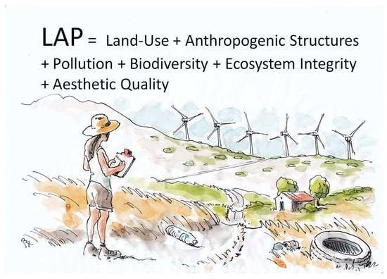
2.1. Protocol Philosophy
2.2. Protocol Review and Selection of Metrics
2.3. Protocol Assessment Procedure
2.4. Protocol Developement and Testing
3. Results
4. Discussion
4.1. A Simple Field Protocol Applied to Complex Cultural Landscapes
4.2. Samothraki LAP Interpretation
4.3. Difficulties, Uncertainties, Validation and Training
4.4. Pros of a Rapid and Multidisciplinary Assessment Method
4.5. Why Use this Assessment Method?
5. Conclusions
Author Contributions
Funding
Acknowledgments
Conflicts of Interest
Appendix A

| 1. Land Use Pattern | |||||||||
| Original landforms, vegetation and cultural landscapes. Traditional elements and features intact. | Original landforms dominate. Slight modern changes and breaks in patterns of traditional land uses. | Moderately degraded. Some signs of changes in traditional land use and bio-physical patterns | Few natural and traditional cultural patterns. Disorder and disharmony, notable signs of degradation. Recent changes evident. | No or minimal natural and traditional cultural features. Modern elements dominate. Multiple recent changes and disorder dominate. | |||||
| 10 | 9 | 8 | 7 | 6 | 5 | 4 | 3 | 2 | 1 or 0 |
| 2. Vegetation | |||||||||
| Natural vegetation or centuries-old traditional culturally-modified vegetation. | >70% natural vegetation or cultural landscape vegetation. Slight modification from reference conditions. | <50% natural vegetation or cultural landscape features. | <30% natural vegetation or cultural landscape vegetation Much degradation and modern pressures affect vegetation. | No natural vegetation; no real centuries old culturally-modified vegetation types. | |||||
| 10 | 9 | 8 | 7 | 6 | 5 | 4 | 3 | 2 | 1 or 0 |
| 3. Flora | |||||||||
| Native flora, natural or near-natural assemblages; or benefited by semi-natural centuries old traditional land-uses. Habitat types/plant communities related to the reference habitat types. | Natural flora present. Slight degradation due to anthropogenic influence; otherwise natural floral assemblages cover >70%. | Impacted by human pressures. Tolerant species present; low species diversity due to human pressures. | Disturbed plant communities. Non-native species may dominate. Degraded by anthropogenic pressures, recent modern changes affecting flora. | ||||||
| 10 | 9 | 8 | 7 | 6 | 5 | 4 | 3 | 2 | 1 or 0 |
| 4. Road Network | |||||||||
| No modern paved roads; only traditional trails, tracks, cobbled and other very old routes evident. | Only small dirt roads present. Very low-density road network, >70% of view has no roads present. | Few roads; no large highways or many paved roads but paved road network covers several parts of landscape. | Road network nearly dominant. Evidence of bad engineering practices. Habitat fragmentation evident. | Road network dominant in landscape. Even when few roads, road network creates widespread degradation (visible erosion, lands-slides, fragmentation etc) | |||||
| 10 | 9 | 8 | 7 | 6 | 5 | 4 | 3 | 2 | 1 or 0 |
| 5. Modern Anthropogenic Interference | |||||||||
| Human-built structures are traditional (all). No urban, industrial or other sprawl. No structures or buildings breaking the horizon (no wind farms, electricity networks etc). Rural or natural scene dominates. | Slight influence of human-made structures (very few utility poles, isolated or single structure). No structures or buildings breaking the horizon (e.g., pylons, electric wires, wind farms etc). Rural or natural scene dominates. | Modern anthropogenic structures immediately apparent. A few structures slightly breaking the horizon at least in one position on the horizon. Rural/natural environment still dominates. In urban areas this state is near-reference (much green-space, traditional architecture). | High anthropogenic structures evident in some areas (electric wires, tall structures). Modern buildings and high structures break the horizon at several (2–5) places on the horizon. Urban or peri-urban environment with good planning but some slight disorder and loss of integrity present. (Some structures may be far away; e.g., wind farms at a distance). | Totally degraded by modern anthropogenic structures. Recent modern landscape-level changes. Many structures such as new buildings and other structures breaking the horizon at several places (5+) on the horizon. Wind farms may dominate on nearby ridgelines and break horizon at several places. | |||||
| 10 | 9 | 8 | 7 | 6 | 5 | 4 | 3 | 2 | 1 or 0 |
| 6. Pollution, Garbage & Debris | |||||||||
| No garbage, and no heavy construction site debris or other anthropogenic debris in sight. | Very small quantities of garbage scattered. Slightly altered conditions due to old dumping (very localized). | Noticeable scattered trash. Some scattered construction-site debris may be evident. Slightly altered conditions due to general disorder (old dumping but very localized). | Several areas of garbage dumped in sight and/or large quantities of debris. Toxics may be present. Extensive infilling may be apparent (e.g., in-filled wetlands). Water pollution evident. | Severe dumping. Garbage and trash dump in sight. Much of trash and debris dumped in large quantities (10+ truckloads). Also may include large mounds of debris or other forms of pollution. Toxic chemical dumping may be present. | |||||
| 10 | 9 | 8 | 7 | 6 | 5 | 4 | 3 | 2 | 1 or 0 |
| 7. Agriculture | |||||||||
| If agriculture present only traditional forms exist in mixed small- scale; i.e., small parcels No modern monocultures. High nature value farming practices evident. | Biodiversity rich agricultural lands with high nature value farming practices but slight degradation. Some monocultures present (but usually, less than <30% of landscape under monocultures). Other forms traditional agriculture and small-scale holdings dominate. | Moderate agriculture impact. Monocultures present. Low nature value farming practices evident. Varied agricultural practices with much “nature” still present on farms despite increased intensification patterns. | At least up to 50% of landscape in modern monocultures. Many associated modern infrastructure elements. Intensive farming (e.g., greenhouses) and industrial farms low naturalness. | Excessive intensive agriculture or poorly placed crops; dominant chemically-supported industrial agriculture. Monocultures dominate and modern farming structures (greenhouses etc). No or weak signs of “nature” present on farms. | |||||
| 10 | 9 | 8 | 7 | 6 | 5 | 4 | 3 | 2 | 1 or 0 |
| 8. Livestock Grazing | |||||||||
| Livestock grazing conditions natural or sustaining traditional landscapes (no recent abandonment evidenced). If no grazing apparent; wildlife grazing evident. | Slight evidence of negative grazing impacts. Some overgrazing or abandonment may be evidenced. Otherwise impacts of grazing not detrimental to biodiversity. | Moderate evidence of negative grazing impacts that may show recent vegetation degeneration or degrading certain habitats. Strong grazing impact or conversely recent “total abandonment”. | Overgrazed conditions. Noticeable vegetation degeneration process (changes in ecological succession pattern). Erosion from trampling. Stunted shrub and tree growth. Grass and herb scarcity. Livestock droppings and trails in abundance. Grazing after fire/logging and associated with vegetation clearing. (Assessment of overgrazed status varies with respect to vegetation type and cultural traditional land-uses). | ||||||
| 10 | 9 | 8 | 7 | 6 | 5 | 4 | 3 | 2 | 1 or 0 |
| 9. Hydrologic Alteration | |||||||||
| All river and streams in apparently natural condition. No dams, no serious water withdrawals, no dikes or other structures affecting flow regime or limiting the stream access to the floodplain. Wetland conditions in natural or near-natural state. | Withdrawals, although present, do not affect natural flow regime and/or available habitat for biota. Wetlands in good condition despite some alteration or human-induced changes. | Significant negative anthropogenic effects to flow regime exist. Moderate changes throughout river basin evident. | Degraded hydrology.Water withdrawals significantly affect flow regime and/or available habitat for biota. | Totally degraded hydrology. Withdrawals, channelization or piping have caused complete alteration of flow regime and severe loss of habitat, severely affecting aquatic biota. Dams may be present; severely degraded wetlands. | |||||
| 10 | 9 | 8 | 7 | 6 | 5 | 4 | 3 | 2 | 1 or 0 |
| 10. Shorelines &/or Riparian Conditions | |||||||||
| All shorelines natural. No roads, buildings, harbors or noticeable artificial structures. Coastal process and riparian areas in natural structure and functioning. | All shorelines in near-natural condition. Slight changes and localized degradation (e.g., by a few roads, isolated buildings or other minor modern structures). | Moderate change apparent (nearly 30% of shoreline/riparian zones altered). | Most of the shorelines/and or riparian zones (>50%) altered or built-up by modern uses and infrastructures. Less than 30% natural vegetation present. | Shorelines/and or riparian zones built up; altered by modern uses and infrastructures. No natural floodplains or riparian habitats. Only tolerant and alien species dominate. | |||||
| 10 | 9 | 8 | 7 | 6 | 5 | 4 | 3 | 2 | 1 or 0 |
| 11. Soundscape Quality | |||||||||
| 100% natural and traditional authentic sounds dominate. No artificial modern (e.g., mechanical sounds). | Nearly all near-natural and traditional sounds dominate. Slight mechanical sounds in distance (but no frequent road noise). | Small road and/or scattered modern agricultural noise break up natural or traditional cultural sounds (e.g., road noise in the distance). | >70% modern anthropogenic sound dominate. Heavy road noise or other sources (e.g., overflying planes frequent). | 100% mechanical sounds dominate. No or very few natural sounds. | |||||
| 10 | 9 | 8 | 7 | 6 | 5 | 4 | 3 | 2 | 1 or 0 |
| 12. Landscape Attractiveness | |||||||||
| Exceptionally attractive; richly varied; rare landscape. Exemplar natural or cultural features or elements. Outstanding scenic quality. | High attractiveness; only slight conditions or elements impinging on natural/cultural elements. Remarkable scenic beauty. | Average attractiveness. Moderate natural elements, but some modern changes. Some degradation. | Poor attractiveness. Degraded by human changes. Unattractive features or elements. | Degraded; drab; unattractive. Altered by human interventions and not scenic in any way. | |||||
| 10 | 9 | 8 | 7 | 6 | 5 | 4 | 3 | 2 | 1 or 0 |
| 13. Smellscape Pleasantness | |||||||||
| No unpleasant smells; natural and culturally authentic smells dominate. | Moderate artificial slightly unpleasant smell from human sources. | Unpleasant smells related to anthropogenic degradation. | Very unpleasant smell from anthropogenic sources. | ||||||
| 10 | 9 | 8 | 7 | 6 | 5 | 4 | 3 | 2 | 1 or 0 |
| 14. Wildlife and Wildlife Habitat | |||||||||
| Wildlife habitat-rich landscape. Usually scarce “special habitats” present (e.g., wetlands). Species intolerant of urban or disturbed areas present. Evidence of relatively high wildlife population density (specialist species of birds/insects may be evident). | Good conditions for wildlife; species intolerant of urban areas and/or rare or specialist species present. No or few domestic/feral/invasive species apparent. Some scarce “special habitats” present (e.g., wetlands, woods, cliffs, scarce resources, etc). | Moderate wildlife populations evident but populations low and some “tolerant species” present or prevalent (far from what would be expected in natural conditions). No/or degraded "special habitats". | Poor, human-altered wildlife habitat. No special conditions or refugia (no “special habitats” present). Some wildlife may be present or their habitat potential present; but mostly “tolerant species” (e.g., urban species). | Nearly no wildlife habitat present. No wildlife present (or only overflying and far from location of site assessment). Completely degraded habitats for wildlife. | |||||
| 10 | 9 | 8 | 7 | 6 | 5 | 4 | 3 | 2 | 1 or 0 |
| 15. Buildings | |||||||||
| If outside defined settlement, modern buildings are only in defined legal area. If inside settlement, if not illegal or unsightly (i.e., in harmony, balance, order) and traditional features well preserved. High authenticity and order in urban, peri-urban environments. | Moderate landscape degradation due to buildings, but very little sprawl effect. | If outside defined settlement, several modern buildings and sprawl (breaks in natural or traditional construction patterns). No traditional architecture. If inside settlement illegal or unsightly elements dominate (i.e., disharmony, disorder, incompatible forms etc.) | |||||||
| 10 | 9 | 8 | 7 | 6 | 5 | 4 | 3 | 2 | 1 or 0 |
References
- Rapport, D.; Gaudet, C.; Karr, J.; Baron, J.; Bohlen, C.; Jackson, W.; Jones, B.; Naiman, R.; Norton, B.; Pollock, M. Evaluating landscape health: Integrating societal goals and biophysical process. J. Environ. Manag. 1998, 53, 1–15. [Google Scholar] [CrossRef]
- Robinson, J.G. Ethical pluralism, pragmatism, and sustainability in conservation practice. Biol. Conserv. 2011, 144, 958–965. [Google Scholar] [CrossRef]
- Wiens, J.A. Landscape ecology as a foundation for sustainable conservation. Landsc. Ecol. 2008, 24, 1053–1065. [Google Scholar] [CrossRef]
- Bastian, O.; Krönert, R.; Lipský, Z. Landscape Diagnosis on Different Space and Time Scales – A Challenge for Landscape Planning. Landsc. Ecol. 2006, 21, 359–374. [Google Scholar] [CrossRef]
- Conrad, E.; Cassar, L.F. Landscape Approaches for Ecosystem Management in Mediterranean Islands; Institute of Earth Systems, University of Malta: Msida, Malta, 2012; ISBN 978-99957-808-0-7. [Google Scholar]
- Lothian, A. Landscape Quality Assessment of South Australia. Ph.D. Thesis, Department of Geographical and Environmental Studies, University of Adeleide, Adeleide, Australia, 2000. [Google Scholar]
- Jones, M. The European Landscape Convention and the question of public participation. Landsc. Res. 2007, 32, 613–633. [Google Scholar] [CrossRef]
- Daniel, T.C. Whither scenic beauty? Visual landscape quality assessment in the 21st century. Landsc. Plan. 2001, 54, 267–281. [Google Scholar] [CrossRef]
- Brunetta, G.; Voghera, A. Evaluating Landscape for Shared Values: Tools, Principles, and Methods. Landsc. Res. 2008, 33, 71–87. [Google Scholar] [CrossRef]
- Hou, Y.; Burkhard, B.; Müller, F. Uncertainties in landscape analysis and ecosystem service assessment. J. Environ. Manag. 2013, 127, S117–S131. [Google Scholar] [CrossRef]
- Vlami, V.; Kokkoris, I.P.; Kehayias, G.; Zogaris, S.; Cartalis, C.; Dimopoulos, P. Cultural landscapes and attributes of “culturalness” in protected areas: An exploratory assessment in Greece. Sci. Total. Environ. 2017, 595, 229–243. [Google Scholar] [CrossRef]
- Dakin, S. There’s more to landscape than meets the eye: Towards inclusive landscape assessment in resource and environmental management. Can. Geogr. 2003, 47, 185–200. [Google Scholar] [CrossRef]
- Walton, J.; Pringle, H.J.R. The Ecosystem Management Understanding (EMU) pilot project—Building landscape literacy using local knowledge to improve rangeland health in the Neales River Catchment of South Australia. In Proceedings of the 16th Biennial Conference of the Australian Rangeland Society, Bourke, Australia, 26–30 September 2010; Eldridge, D.J., Waters, C., Eds.; Australian Rangeland Society: Perth, Australia, 2010. [Google Scholar]
- Jensen, L.H. Changing conceptualization of landscape in English landscape assessment methods. In From Landscape Research to Landscape Planning; Tress, B., Tres, G., Fry, G., Opdam, P., Eds.; Springer: Dordrecht, The Netherlands, 2006; Volume 12, pp. 161–171. ISBN 978-1-4020-3978-2. [Google Scholar]
- Bieling, C.; Plieninger, T. Recording Manifestations of Cultural Ecosystem Services in the Landscape. Landsc. Res. 2013, 38, 649–667. [Google Scholar] [CrossRef]
- Simensen, T.; Halvorsen, R.; Erikstad, L. Methods for landscape characterisation and mapping: A systematic review. Land Use Policy 2018, 75, 557–569. [Google Scholar] [CrossRef]
- Herlin, I.S. Exploring the national contexts and cultural ideas that preceded the Landscape Character Assessment method in England. Landsc. Res. 2016, 41, 1–11. [Google Scholar]
- Reynard, E.; Fontana, G.; Kozlik, L.; Scapozza, C. A method for assessing the scientific and additional values of geomorphosites. Geogr. Helv. 2007, 62, 148–158. [Google Scholar] [CrossRef]
- Yin, L.; Lin, H.; Huang, Y. Study on urban quality assessment index system of waterfront landscapes. Landsc. Res. 2015, 7, 31. [Google Scholar]
- Anfuso, G.; Williams, A.T.; Martínez, G.C.; Botero, C.M.; Hernández, J.C.; Pranzini, E. Evaluation of the scenic value of 100 beaches in Cuba: Implications for coastal tourism management. Ocean Coast Manag. 2017, 142, 173–185. [Google Scholar] [CrossRef]
- Key, C.H.; Benson, N.C. Landscape Assessment. Technical Manuscript from: FIREMON: Fire Effects Monitoring and Inventory System; Gen. Tech. Rep. RMRS-GTR-164-CD; USDA & US Forest Service: Fort Collins, CO, USA, 2006. Available online: https://www.fs.fed.us/rm/pubs/rmrs_gtr164/rmrs_gtr164_13_land_assess.pdf (accessed on 14 December 2018).
- Brown, M.T.; Vivas, M.B. Landscape Development Intensity Index. Environ. Monit. Assess. 2005, 101, 289–309. [Google Scholar] [CrossRef]
- Panagopoulos, T. Linking forestry, sustainability and aesthetics. Ecol. Econ. 2009, 68, 2485–2489. [Google Scholar] [CrossRef]
- Loures, L.; Loures, A.; Nunes, J.R.; Panagopoulos, T. Landscape Valuation of Environmental Amenities throughout the Application of Direct and Indirect Methods. Sustainability 2015, 7, 794–810. [Google Scholar] [CrossRef] [Green Version]
- Ramos, B.R.; Panagopoulos, T. Landscape evaluation as an integrant part of the rehabilitation process in urban landscapes. In Latest Trends on Urban Planning and Transportation; Wseas Press: Athens, Greece, 2010; pp. 123–128. ISBN 978-960-474-204-2. [Google Scholar]
- Yilmaz, K.T. Incorporating vegetation analysis into ecological characterization of landscapes: The Turkish case. Fitosociologia 2011, 48, 83–92. [Google Scholar]
- Tomaselli, V.; Dimopoulos, P.; Marangi, C.; Kallimanis, A.S.; Adamo, M.; Tarantino, C.; Panitsa, M.; Terzi, M.; Veronico, G.; Lovergine, F.P.; et al. Translating land cover/land use classifications to habitat taxonomies for landscape monitoring: A Mediterranean assessment. Landsc. Ecol. 2013, 28, 905–930. [Google Scholar] [CrossRef]
- Antrop, M.; Van Eetvelde, V. Landscape Perspectives: The Holistic Nature of Landscape; Springer: Dordrecht, The Netherlands, 2017; ISBN 978-94-024-1183-6. [Google Scholar]
- Palmer, J.F.; Hoffman, E.R. Rating reliability and representation validity in scenic landscape assessments. Landsc. Plan. 2001, 54, 149–161. [Google Scholar] [CrossRef]
- Hatzistathis, A.; Ispikoudis, I. Nature Protection and Landscape Architecture, 2nd ed.; Giahudi-Giapuli: Thessaloniki, Greece, 1995. (In Greek) [Google Scholar]
- Andreasen, J.K.; O’Neill, R.V.; Noss, R.; Slosser, N.C. Considerations for the development of a terrestrial index of ecological integrity. Ecol. Indic. 2001, 1, 21–35. [Google Scholar] [CrossRef] [Green Version]
- Müller, F.; de Groot, R.; Willemen, L. Ecosystem services at the landscape scale: The need for integrative approaches. Landsc. Online 2010, 23, 1–11. [Google Scholar]
- Schlee, M.B.; Tamminga, K.R.; Tângari, V.R. A Method for Gauging Landscape Change as a Prelude to Urban Watershed Regeneration: The Case of the Carioca River, Rio de Janeiro. Sustainability 2012, 4, 2054–2098. [Google Scholar] [CrossRef] [Green Version]
- Vogiatzakis, I.N.; Griffiths, G.H. Landscape ecology in practice: Tools for conservation and management in the Mediterranean. In Landscape Approaches for Ecosystem Management in Mediterranean Islands; Conrad, E., Cassar, L.F., Eds.; Institute of Earth Systems, University of Malta: Msida, Malta, 2012; pp. 11–20. ISBN 978-99957-808-0-7. [Google Scholar]
- Kobori, H.; Dickinson, J.L.; Washitani, I.; Sakurai, R.; Amano, T.; Komatsu, N.; Kitamura, W.; Takagawa, S.; Koyama, K.; Ogawara, T.; et al. Citizen science: A new approach to advance ecology, education, and conservation. Ecol. Res. 2015, 31, 1–19. [Google Scholar] [CrossRef]
- Datry, T.; Pella, H.; Leigh, C.; Bonada, N.; Hugueny, B. A landscape approach to advance intermittent river ecology. Freshw. Boil. 2016, 61, 1200–1213. [Google Scholar] [CrossRef]
- Bjorkland, R.; Pringle, C.M.; Newton, B. A Stream Visual Assessment Protocol (SVAP) for Riparian Landowners. Environ. Monit. Assess. 2001, 68, 99–125. [Google Scholar] [CrossRef]
- Munné, A.; Prat, N.; Sola, C.; Bonada, N.; Rieradevall, M. A simple field method for assessing the ecological quality of riparian habitat in rivers and streams: QBR index. Aquat. Conserv. Mar. Freshw. Ecosyst. 2002, 13, 147–163. [Google Scholar] [CrossRef]
- Esselman, P.C. The Monkey River Baseline Study: Basic and Applied Research for Monitoring and Assessment in Southern Belize. Master’s Thesis, University of Georgia, Athens, GA, USA, 2001. [Google Scholar]
- Zogaris, S.; Bjorkland, R.; Bjorkland, R.H.; Chatzinikolaou, Y.; Giakoumi, S.; Economou, A.N.; Dimopoulos, P. Rapid visual assessment protocols for monitoring in riparian zones. In Sustainable Riparian Zones—A Management Guide; Arizpe, D., Mendes, A., Rabaça, J.E., Eds.; Generalitat Valenciana: Valencia, Spain, 2008; pp. 127–141. ISBN 978-84-482-4967-0. [Google Scholar]
- Chatzinikolaou, Y.; Ntemiri, K.; Zogaris, S. River riparian zone assessment using a rapid site-based index in Greece. Fresenius Environ. Bull. 2011, 20, 296–302. [Google Scholar]
- Fernández, D.; Barquin, J.; Raven, P. A review of river habitat characterisation methods: Indices vs. characterisation protocols. Limnetica 2011, 30, 217–234. [Google Scholar]
- Karr, J.R. Seven foundations of biological monitoring and assessment. Biol. Ambient. 2006, 20, 7–18. [Google Scholar]
- Roche, P.K.; Campagne, C.S. From ecosystem integrity to ecosystem condition: A continuity of concepts supporting different aspects of ecosystem sustainability. Curr. Opin. Environ. Sustain. 2017, 29, 63–68. [Google Scholar] [CrossRef]
- Mazri, C.; Jovanovic, A.; Balos, D. Descriptive model of indicators for environment, health and safety management. Chem. Eng. Trans. 2012, 26, 471–476. [Google Scholar]
- Mazri, C.; Jovanovic, A.; Balos, D. Set of Key Performance Indicators Related to Emerging Risks; Report in FP7 Project iNTeg-Risk Early Recognition, Monitoring and Integrated Management of Emerging, New Technology Related Risks; EU FP7 (Grant Agreement no. CP-IP 213345-2); European Union: Brussels, Belgium, 2011. [Google Scholar]
- Karr, J.R. Defining and measuring river health. Freshw. Boil. 1999, 41, 221–234. [Google Scholar] [CrossRef] [Green Version]
- Tveit, M.S. Indicators of visual scale as predictors of landscape preference; a comparison between groups. J. Environ. Manag. 2009, 90, 2882–2888. [Google Scholar] [CrossRef]
- Zhang, M.; Kang, J. Towards the evaluation, description, and creation of soundscapes in urban open spaces. Environ. Plan. B Plan. Des. 2007, 34, 68–86. [Google Scholar] [CrossRef]
- Mazaris, A.D.; Kallimanis, A.S.; Chatzigianidis, G.; Papadimitriou, K.; Pantis, J.D. Spatiotemporal analysis of an acoustic environment: Interactions between landscape features and sounds. Landsc. Ecol. 2009, 24, 817–831. [Google Scholar] [CrossRef]
- Xiao, J.; Tait, M.; Kang, J. A perceptual model of smellscape pleasantness. Cities 2018, 76, 105–115. [Google Scholar] [CrossRef]
- Fry, G.; Tveit, M.; Ode, A.; Velarde, M. The ecology of visual landscapes: Exploring the conceptual common ground of visual and ecological landscape indicators. Ecol. Indic. 2009, 9, 933–947. [Google Scholar] [CrossRef]
- Rackham, O.; Moody, J. The making of the Cretan landscape; Manchester University Press: Manchester, UK, 1996; ISBN 978-0719036477. [Google Scholar]
- Nixon, L.; Rackham, O.; Grove, A.T. The Nature of Mediterranean Europe. An Ecological History. J. Rom. Stud. 2001, 91, 196. [Google Scholar] [CrossRef]
- Fetzel, T.; Petridis, P.; Noll, D.; Singh, S.J.; Fischer-Kowalski, M. Reaching a socio-ecological tipping point: Overgrazing on the Greek island of Samothraki and the role of European agricultural policies. Land Use Policy 2018, 76, 21–28. [Google Scholar] [CrossRef]
- Voulvoulis, N.; Arpon, K.D.; Giakoumis, T. The EU Water Framework Directive: From great expectations to problems with implementation. Sci. Total. Environ. 2017, 575, 358–366. [Google Scholar] [CrossRef] [PubMed] [Green Version]
- Scoullos, M. (Ed.) Sustainable Mediterranean: Samothraki Summer University 2016: Integrated Management Approaches for Biosphere Reserves and other Designated Areas. Sustainable Mediterranean Special Issue. Available online: Mio-ecsde.org/wp-content/uploads/2017/01/Sustainable-Mediterranean-73.pdf (accessed on 14 December 2018).
- Biel, B.; Tan, K. Flora of Samothraki; The Goulandris Natural History Museum: Kifissia, Greece, 2014; ISBN 9789604646005. [Google Scholar]
- Skoulikidis, N.; Lampou, A.; Karaouzas, I.; Gritzalis, K.; Lazaridou, M.; Zogaris, S. Stream ecological assessment on an Aegean island: Insights from an exploratory application on Samothraki (Greece). Fresenius Environ. Bull. 2014, 23, 1173–1182. [Google Scholar]
- Fischer-Kowalski, M.; Xenidis, L.; Singh, S.J.; Pallua, I. Transforming the Greek Island of Samothraki into a UNESCO Biosphere Reserve. An Experience in Transdisciplinarity. GAIA Ecol. Perspect. Sci. Soc. 2011, 20, 181–190. [Google Scholar] [CrossRef] [Green Version]
- Petridis, P.; Fischer-Kowalski, M.; Singh, S.J.; Noll, D. The role of science in sustainability transitions: Citizen science, transformative research, and experiences from Samothraki island, Greece. ISL Stud. J. 2017, 12, 115–134. [Google Scholar] [CrossRef]
- Terkenli, T.S. Towards a theory of the landscape: The Aegean landscape as a cultural image. Landsc. Plan. 2001, 57, 197–208. [Google Scholar] [CrossRef]
- Pasimeni, M.R.; Valente, D.; Semeraro, T.; Petrosillo, I.; Zurlini, G. Anthropogenic Landscapes. In Encyclopedia of Ecology, 2nd ed.; Fath, B.D., Ed.; Elsevier: Oxford, UK, 2019; Volume 4, pp. 472–481. [Google Scholar]
- Blondel, J. On humans and wildlife in Mediterranean islands. J. Biogeogr. 2008, 35, 509–518. [Google Scholar] [CrossRef] [Green Version]
- Balzan, M.V.; Pinheiro, A.M.; Mascarenhas, A.; Morán-Ordóñez, A.; Ruiz-Frau, A.; Carvalho-Santos, C.; Vogiatzakis, I.N.; Arends, J.; Santana-Garçon, J.; Roces-Díaz, J.V.; et al. Improving ecosystem assessments in Mediterranean social-ecological systems: A DPSIR analysis. Ecosyst. People 2019, in press. [Google Scholar]
- Karadimou, G.; Doani, S.; Albanakis, K.; Domakinis, C.; Mouratidis, A.; Vouvalidis, K.; Oikonomidis, D. Identification of assessment indicators for landscape in Greece. In Proceedings of the 10th International Congress of the Hellenic Geographical Society, Thessaloniki, Greece, 22–24 October 2015. [Google Scholar]
- Gkoltsiou, A.; Terkenli, T.S. An interdisciplinary analysis of tourist landscape structure. Tourismos 2012, 7, 145–164. [Google Scholar]
- Pendrill, L.R.; Emardson, R.; Berglund, B.; Gröning, M.; Höglund, A.; Cancedda, A.; Quinti, G.; Crenna, F.; Rossi, G.B.; Drnovsek, J.; et al. Measurement with persons: A European network. NCSL Int. Meas. 2010, 5, 42–54. [Google Scholar] [CrossRef]
- Striner, A.; Preece, J. StreamBED: Training citizen scientists to make qualitative judgments using embodied virtual reality training. In Proceedings of the 2016 CHI Conference Extended Abstracts on Human Factors in Computing Systems, San Jose, CA, USA, 7–12 May 2016; pp. 1201–1207. [Google Scholar]
- Butler, A.; Berglund, U. Landscape character assessment as an approach to understanding public interests within the European landscape convention. Landsc Res. 2012, 39, 219–236. [Google Scholar] [CrossRef]
- Berleant, A. The Aesthetics of Environment; Temple University Press: Philadelphia, PA, USA, 1992. [Google Scholar]
- Berleant, A. What is Aesthetics Engagement? Contemp. Aesthet. 2013, 11. Available online: https://contempaesthetics.org/newvolume/pages/article.php?articleID=684 (accessed on 14 December 2018).
- Rapport, D.J.; Whitford, W.G.; Hildén, M. Common patterns of ecosystem breakdown under stress. Environ. Monit. Assess. 1998, 51, 171–178. [Google Scholar] [CrossRef]
- Nakagoshi, N. How to Conserve Japanese Cultural Landscapes: The Registration System for Cultural Landscapes. In Ecological Research Monographs; Springer: Berlin/Heidelberg, Germany, 2011; pp. 249–275. [Google Scholar]
- Plieninger, T.; Kizos, T.; Bieling, C.; Le Dû-Blayo, L.; Budniok, M.-A.; Bürgi, M.; Crumley, C.L.; Girod, G.; Howard, P.; Kolen, J.; et al. Exploring ecosystem-change and society through a landscape lens: Recent progress in European landscape research. Ecol. Soc. 2015, 20, 5. [Google Scholar] [CrossRef]
- Vallés-Planells, M.; Galiana, F.; Van Eetvelde, V. A Classification of Landscape Services to Support Local Landscape Planning. Ecol. Soc. 2014, 19, 1–44. [Google Scholar] [CrossRef]
- Ariza-Montobbio, P.; Farrell, K.N. Wind Farm Sitting and Protected Areas in Catalonia: Planning Alternatives or Reproducing One-Dimensional Thinking? Sustainability 2012, 4, 3180–3205. [Google Scholar] [CrossRef]
- Schaich, H.; Bieling, C.; Plieninger, T. Linking Ecosystem Services with Cultural Landscape Research. GAIA Ecol. Perspect. Sci. Soc. 2010, 19, 269–277. [Google Scholar] [CrossRef] [Green Version]
- Aretano, R.; Petrosillo, I.; Zaccarelli, N.; Semeraro, T.; Zurlini, G. People perception of landscape change effects on ecosystem services in small Mediterranean islands: A combination of subjective and objective assessments. Landsc. Plan. 2013, 112, 63–73. [Google Scholar] [CrossRef]
- Kokkoris, I.; Dimopoulos, P.; Xystrakis, F.; Tsiripidis, I. National scale ecosystem condition assessment with emphasis on forest types in Greece. One Ecosyst. 2018, 3, e25434. [Google Scholar] [CrossRef]
- Ryfield, F.; Cabana, D.; Brannigan, J.; Crowe, T. Conceptualizing ‘sense of place’ in cultural ecosystem services: A framework for interdisciplinary research. Ecosyst. Serv. 2019, 36, 100907. [Google Scholar] [CrossRef]


| Thematic Category | Final Metric | Summary Rationale for Inclusion | Indicative Literature |
|---|---|---|---|
| Land-use | Land Use Pattern | Integrative; degradation gradient perceivable. Naturalness and traditional cultural land-uses define reference conditions. | [18,33,48,52] |
| Agriculture | Integrative; degradation gradient perceivable. Traditional land-uses and high nature value farming define reference conditions. | [1,2,52] | |
| Human-made structures | Roads Network | Visual, semi-quantitative. References defined by no or minimal road network in natural areas; higher density road network progressively shows degradation. | [1,52] |
| Buildings | Visual, semi-quantitative. Different approaches to assessment in build-up versus non-urban conditions. Aspects of authenticity and order also considered in defining reference conditions in built-up areas. | [19,52] | |
| Modern Anthropogenic Interference | Visual, semi-quantitative. Refers to dominating modern artificial structures and disorder (i.e., structures breaking horizon) | [33,37] | |
| Pollution | Pollution, Garbage & Debris | Visual, semi-quantitative/qualitative; degradation gradient perceivable. Quantities, extent of spread and toxicity of anthropogenic waste materials considered. | [37,39] |
| Smellscape Pleasantness | Olfactory, qualitative. Natural and “culturally authentic” smells versus artificial smells guide assessment. | [51] | |
| Biodiversity | Flora | Integrative natural history observation; degradation gradient perceivable (concerns alien species and human-induced species impoverishment) | [26,38,52] |
| Wildlife & Wildlife habitat | Integrative natural history observation; degradation gradient perceivable. Concerns presence of high quality wildlife habitat types. | [31,33,47] | |
| Ecosystem integrity | Vegetation | Integrative natural history observation; degradation gradient perceivable. Considers both natural and traditional culturally-modified vegetation types. | [48,53,54] |
| Shorelines &/or Riparian Conditions | Integrative natural history observation; degradation gradient perceivable. Considers both natural and traditional culturally-modified vegetation types; riparian quality emphasized (i.e., extent and naturalness). | [37,38] | |
| Hydrologic Alteration | Integrative observation; degradation gradient perceivable. Absence of water abstraction or storage structures (dams, dikes). | [20,27,29,33,37,47] | |
| Livestock Grazing | Integrative natural history observation; degradation gradient perceivable by trained observer. Visual-indicators of overgrazing affect plant communities and growth-form structure. Specific indicators are related to local conditions. | [53,54,55] | |
| Aesthetic quality | Landscape Attractiveness | Visual, qualitative. Scenic qualities, rarity, and variety are included in reference conditions. | [6,18,29,33,48,52] |
| Soundscape Quality | Acoustic, qualitative. Naturalness defines reference conditions. | [49,50] |
| Quality Class Condition | Condition Description | LAP CI | Mapping Colour |
|---|---|---|---|
| Excellent | Favorable conservation condition. Natural/ semi-natural landscape or exceptional quality cultural landscape with high degree of natural elements and features. | ≥85 | Dark Green |
| Good | Favorable conservation condition. Near natural or cultural landscape with slight degradation; high quality urban or peri-urban landscape | 70–84 | Green |
| Moderate | Unfavorable conservation condition. Moderately degraded landscape with various modern changes and pressures. | 50–69 | Yellow |
| Poor | Unfavorable conservation condition. Degraded landscape. Moderately degraded urban or peri-urban area | 31–49 | Orange |
| Bad | Unfavorable conservation condition. Severely degraded non-urban landscape or degraded cultural/urban landscape | ≤30 | Red |
| LAP Quality Class | Number of Sites (Expert Scores) | Number of Sites Where Majority of Assessors (3/4) Scored Significantly Different (p-Value < 0.2) than the Export Score |
|---|---|---|
| Excellent | 4 | 1 |
| Good | 18 | 1 |
| Moderate | 9 | 1 |
| Poor | 3 | 2 |
| Bad | 1 | 1 |
| Metrics | Number of Sites with std > 2 | Percent Unscored |
|---|---|---|
| Road Network | 0 | 1.8 |
| Flora | 1 | 1.2 |
| Agriculture | 1 | 22.4 |
| Soundscape Quality | 1 | 1.2 |
| Garbage & Debris | 2 | 1.2 |
| Buildings & Urban sprawl | 2 | 8.8 |
| Land Use Pattern | 3 | 1.2 |
| Modern Anthropogenic Interference | 3 | 1.2 |
| Hydrological Alternation | 3 | 45.3 |
| Shorelines &/or Riparian Condition | 3 | 31.8 |
| Landscape Attractiveness | 3 | 1.8 |
| Abandonment * | 3 | 46.5 |
| Vegetation | 4 | 1.2 |
| Wildlife & Wildlife Habitat | 4 | 65.3 |
| Livestock Grazing | 8 | 9.4 |
© 2019 by the authors. Licensee MDPI, Basel, Switzerland. This article is an open access article distributed under the terms and conditions of the Creative Commons Attribution (CC BY) license (http://creativecommons.org/licenses/by/4.0/).
Share and Cite
Vlami, V.; Zogaris, S.; Djuma, H.; Kokkoris, I.P.; Kehayias, G.; Dimopoulos, P. A Field Method for Landscape Conservation Surveying: The Landscape Assessment Protocol (LAP). Sustainability 2019, 11, 2019. https://doi.org/10.3390/su11072019
Vlami V, Zogaris S, Djuma H, Kokkoris IP, Kehayias G, Dimopoulos P. A Field Method for Landscape Conservation Surveying: The Landscape Assessment Protocol (LAP). Sustainability. 2019; 11(7):2019. https://doi.org/10.3390/su11072019
Chicago/Turabian StyleVlami, Vassiliki, Stamatis Zogaris, Hakan Djuma, Ioannis P. Kokkoris, George Kehayias, and Panayotis Dimopoulos. 2019. "A Field Method for Landscape Conservation Surveying: The Landscape Assessment Protocol (LAP)" Sustainability 11, no. 7: 2019. https://doi.org/10.3390/su11072019