Agent-Based Analysis of Urban Spaces Using Space Syntax and Spatial Cognition Approaches: A Case Study in Bari, Italy


Department of Civil, Environmental, Land, Construction and Chemistry (DICATECh), Polytechnic University of Bari, 70125 Bari, Italy
*
Author to whom correspondence should be addressed.
Sustainability 2020, 12(11), 4625; https://doi.org/10.3390/su12114625
Submission received: 18 May 2020
/
Revised: 1 June 2020
/
Accepted: 2 June 2020
/
Published: 5 June 2020
(This article belongs to the Special Issue Sustainable Urban Planning Techniques)
Abstract
:The present study provides a reflection on the agent-based intelligence of urban spatial environments through the comparison of a formal quantitative approach, i.e., space syntax, and a qualitative experimentation based on the spatial cognition approach. Until recently, space syntax was adopted by urban planners and designers to support urban design and planning decisions, based on an analysis of the urban physical environment. Researchers in the cognitive science field have increased their attempts to address space syntax techniques to better understand the relationships of cognitive spatial agents with the spatial features of urban environments. In this context, the experimental approach focuses on the qualities of the environment as interacted, perceived and interpreted by cognitive agents and reflects on the role which it plays in affecting spatial decisions and route choices. The present paper aimed to explore the extent to which possible integration between the different approaches can provide insights on agent-based decisions in actions and behavioural processes in space for useful perspectives in urban analysis and planning. Findings suggest relevant correlations between the experimentation results and space syntax predictions when a correspondence of some aspects can be found. Conversely, interesting qualitative insights from the spatial cognition approach are pointed out to enrich the configurational analysis. The potential and constraints of each approach and the ways of combining these are presented. Evidence supports the suitability of the proposal outlined in the present paper within the framework of urban planning practice.
1. Introduction
Until recently, the aspects of spatial cognition activated by agents using common spaces have been addressed with increasing interest by research activities on the use and organization of space environments [1,2,3].
In particular, environments with high complexity have represented an arena of significant possibilities for further study in this context, as traditional models of analysis and interpretation have proven to be insufficient to develop adequate knowledge and support operationally effective decisions. Representative examples are related to situations in which the understanding and conceptualization of spaces is typically multidimensional, dynamic and fuzzy. This was due to the relevant significance expressed not only by the physical space itself, but also by the interpretations given by the agents who—more or less permanently and frequently—interact with this space, thus indissolubly characterizing it.
Typical examples are places with a great concentration of agents, where spaces take on variable geometries and configurations, expanding and/or tightening as a consequence of the relationships that take place between the agents and their interaction space. For example, scholars have studied, with an increasingly refined and profound focus, the ways in which evacuations from buildings are affected by dangerous events that take place. In such cases, the characterization of escape spaces is dynamically dependent on the interpretations of the space by agents mutually stimulated (and/or influenced) by the behaviours of a multi-agent situational context [4]. Again, regarding the use of confined spaces, there are interesting and more consolidated studies on the best characterization and organization of the common spaces of buildings intended for a continuous presence of agents, for example for purposes of cultural or health visits, such as museums, churches or healthcare facilities [5,6]. At the other extreme, the conceptualization of spaces with a low or very low presence of navigating agents also arouses considerable interest. Traditionally considered an undifferentiated or basically uninteresting profile, its characters are instead essential, for example, in needs of spatial orientation (oceans, deserts, large spaces or fields of the agricultural landscape etc.), or of selective enhancement to set up spaces of tourist/exploratory/recreational type (for example in large and increasingly frequently protected environmental areas) [7,8,9]. However, it is not difficult to imagine that the most representative compendium of this spatial complexity is today easily identifiable in the urban settlement. Multifaceted spatial problems coexist in cities, concerning the organization and conceptualization of spaces, the multiscale value and relevance (building–block–neighbourhood–city–territory) of spaces, the behavioural variability of agents in the use of spaces and so on. They often resolve into a multiple and non-univocal spatial configuration, in which physical and geometric characters constitute just one of many attributes—yet often controversial despite its statutory evidence [10,11,12].
In the city, research on spatial cognition has proved essential for highlighting and analysing aspects of complexity, which are intrinsic to the city itself and of great importance for supporting informed spatial decisions. Having entered through models and tools to support navigation and geographic/tourist orientation (map-based navigation apps) [13,14], studies on the conceptualization of spaces has been gradually targeted towards supporting the organization and even the planning of urban spaces and voids. The study of space syntax, on which part of our research effort is based, originated just as a formalized methodology of rich and the intelligence-based analysis of spaces within a built environment. From the seminal works of Hillier [15,16] to the most recent and sophisticated elaborations in the intricate historical centres of European cities [17,18], space syntax allows the identification of aspects of spatial configuration, typically transparent in a traditional spatial analysis. These refined formalizations, however, have an eminently (if not exclusively) geometric physical type and nature, which often show limits in relational, perceptive and interpretative terms. Instead, these terms constitute an essential character of an entity intrinsically signified by attitudinal and behavioural elements such as the city. In this context, but still in the wake of cognitive research on space, less formalized and more qualitative analysis find useful place. While showing limitations in terms of the management of informal, fuzzy analytical data, qualitative analyses are able to investigate the complex characters of the urban space environment in a less behaviourally abstract way. These are often experimental analyses that make extensive use of statistical probabilistic mathematics, but which increasingly tend to use complex modelling formalization approaches, such as foundational ontologies [19,20].
The reflection carried out in the present paper is part of this framework. It is aimed at investigating the potential for comparison and integration between a remarkably formalized methodological approach, attributable to the space syntax analysis, and a more qualitative approach based on the wider field of research of spatial cognition. Yet it is clear that these are not mutually alien approaches, being the cognitive character represented by the Space syntax itself, albeit at the lower level of general perceptiveness, visibility and intelligibility [21,22]. The reflection was developed with an application approach, using an experimental research field started within the spatial planning courses of the Engineering School of the Polytechnic University of Bari (Italy). The experimentation was carried out in the Bari case study.
The structure of this paper is organized as follows. The present section introduces the research domain to address the importance of using an agent-based analysis of human behaviour in space to support urban planning and design, outlining the relevant literature. The second section presents the rationale for this work with a methodology and case study description. Then, in the third and fourth section, both approaches were developed and outputs were presented. The fifth section compares the results and discusses the extent to which the approaches might be coherently combined. Finally, some implications for urban planning and design are discussed, by pointing out perspectives in the area of models of knowledge management to support decision making. Future outlooks of this study end up in the paper.
2. Research Objectives and Case Study Description
The aim of the present paper was to investigate the extent to which a formal space-syntax-based approach and a more qualitative spatial-cognition-based approach show possible features of integration from a spatial planning and/or design support perspective.
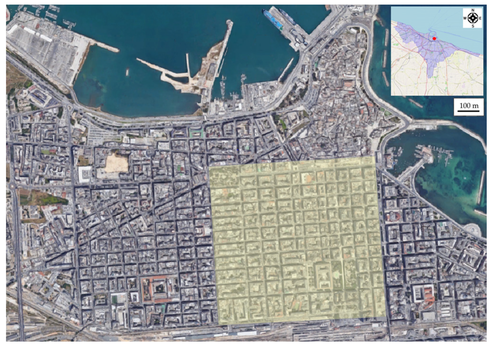
To this end, an analysis with space syntax methodology and an experiment using the spatial cognition approach, of the same urban area located in the Murat district in the city centre of Bari (Italy), were carried out. Bari is the principal city of the Apulia region in southern Italy (Figure 1). It is measures 117.38 km2 with a population of 324,198. This paper studied its Murat neighbourhood (Figure 2).
The Murat district is a square model of Roman derivation and is characterized by regular blocks of perpendicular streets. It was built close to the historical district at the end of the eighteenth century, following Bourbon reform policies for the city as a further expansion of the original urban layout.
The plan of the new district aimed to increase the quantity of residential units. On the main street, Corso Cavour, one block was designated for the theatre, another for the chamber of commerce and others for buildings of historical and architectural value. Around the middle of the century, the development of the railway alongside the streets of the Borgo became an artificial limit to building progression. Nowadays, the district’s activity is focused on the main street of Corso Cavour, along which there is the historical Petruzzelli Theatre and the adjoining Corso Vittorio Emanuele, in which there are important buildings such as the Town Hall and the Niccolò Piccinni Theatre.
For this study, the Murat neighbourhood was selected in order to understand how pedestrians choose alternative routes to a destination in this morphologically well defined grid with low spatial differentiation, which suggests that from a topological point of view, all the roads should have almost equal preference among pedestrians [23].
The applied space syntax approach utilizes quantitative graph-based descriptors of the topological form of urban settings to quantify the relationship between the pedestrian movement densities and the spatial structure, i.e., to predict the pedestrian distribution of movement around cities. The configurational analysis relies on the possible observation that rates of pedestrian flows are affected by the permeability of the configuration of the urban street network [24]. Accessibility is the main factor of navigational choice according to the general principle to which the more a space is accessible and connected to every other space in the system, the more it tends to attract people. Thus, it is possible to approximate potential pedestrian movement flows on streets merely by analysing the configurational organization of the network of walkable space.
This mathematical a-priori analysis of the form of the built environment offers an interpretation of its prescribed social effect, e.g., spatial occupation. It provides an interesting point of contact with the approach based on spatial cognition a-posteriori analysis. This, on the other hand, focuses on the individual’s self-motivated path choices through the environment. This last topic was recently investigated for various aspects by our research group (see e.g., [25,26,27]).
To evaluate the descriptive capacity of spatial use, derived from the configurational analysis of the urban layout, an experiment involving 100 students of the Polytechnic University of Bari was carried out. They were asked to freely explore the area recording their routes using a mobile digital tracking app on personal smartphones. The tracing was stopped when the participants reached a predefined target destination. Moreover, to fully understand their cognitive responses to the urban surroundings, after the outing they were also asked to fill in a post-experimental survey (PES).
The results obtained were analysed and discussed in the context of a spatial cognition approach, where participants were intelligent and active agents in their choice of direction and the elements of the urban environment were understood as perceived by them. The issues that were investigated were the patterns of movement, possible mutual relationships among routes in terms of spatial behaviours and cognition, and the reasons for the agent preferences of space proxemics, e.g., the presence of other agents.
The objective of the spatial cognition methodology was not only to understand the spatial decision-making process at the individual level, but also to sketch out the collective flow of dynamic patterns during an exploratory walk in a path defined by only two points. Indeed, the results were analysed at a cumulative or significatively clustered scale to build a comprehensive description of pedestrian movement in the public area under study and to allow for a meaningful comparison with the configurational analysis. Besides the focus on the determination of what and how contextual factors influenced pedestrian movements, of interest was the understanding of whether the perception of urban space was affected by the time of users’ movements, where each time is associated with different environmental conditions, such as lighting and temperature. The time period refers also to the risk associated with navigating the environment at different times of the day to verify if for some reason, e.g., poorly lit streets, as this increases the perception of risks and these are thus avoided [28].
Where a possible correspondence between both the spatial behaviour observation and the space syntax mapping emerges, then a role of spatial structure itself and its accessibility in promoting certain spaces to be more conducive or hostile for human use and interaction was considered. For instance, streets suffering from both visuo-geometrical (syntactically legible) segregation and low navigation attraction, may suggest significant levels of social misuse for participants, where antisocial behaviour and criminal activities are more likely to occur. Instead, where less correspondence was found, further investigation was carried out with the aid of the surveys to identify other external attractors as well as deterrents in the environment.
3. Space Syntax Application
The space syntax analysis was applied to the study of the urban planimetry of the area of interest, which consisted of a network of walkable spaces made up of a series of interconnecting street paths and public spaces for users. Hence, from the topological configuration of the grid, the reciprocal relationship between its street segments was revealed, e.g., the measurement of the accessibility of each component with respect to all others and the hierarchies, which in turn demonstrate the conditions for pedestrian flow rates [29]. The pace syntax application consisted of four steps: (i) axial analysis, (ii) integration index mapping, (iii) intelligibility calculation and (iv) choice mapping.
3.1. Axial Analysis
The configurational analysis started with the axial analysis applied to the urban grid of our case study and which was elaborated using depthmapX software (version 0.5b, https://varoudis.github.io/depthmapX/). Thus, the Murat neighbourhood of Bari was firstly automatically decoded as an axial map Figure 3a, consisting of the set of the minimum number of continuous axial lines, where each one was the longest straight line of sight with which it was possible to cover the entire space layout [15]. The axial map was built to represent the urban area through the structure of its street network, which was explicitly described as a discrete spatial configuration where the reciprocal interaction between these lines revealed the system relationship. To perform numerical evaluations, the axial map was converted into an axial graph in which each node was an axial line and each edge was an intersection between them. With this derivative formalization, it is possible to account for the component units in which the continuous nature of space is decomposed, and evaluate their mutual relationships using graph-based methods.
This formalization emerges from the hypothesis that the line of sight, intended as a representation of the agent spatial perception, is the major factor of space interpretation and the driver for spatial behaviour. In fact, since following few changes of direction is cognitively simpler than proceeding through many turns, the number of angles turned while navigating had a greater effect on how people move than journey length [21]. Accordingly, agents select routes and destinations based on a distinctive disposition in judging distances, which is related with angular geometry and topological properties of the space configuration more than by their ability to calculate metric distances [30]. Therefore, the distance between the two locations is counted through steps, namely the number of directional turns along a path between each axial line, rather than the actual distance covered [31]. The assumption that pedestrians’ journeys tend to pass through the most accessible paths, combined with such a formalization for the accessibility concept, allows to assess the probability of movement within urban settings with the space syntax analytical method.
3.2. Integration Index Map
To infer the behavioural characteristics of the spatial setting, topological measurements on the graph-based representation of the axial map were carried out. The integration index distribution of axial segments, where segments are each piece of the axial lines between the intersections with other axial lines, was calculated [30]. This is the measurement of topological accessibility for all segments in the network, i.e., it measures the average depth of a segment compared with the others. Thus, higher integration values of a segment indicate that on an average, it is more integrated within the given spatial network and the more integrated it is, the shorter the topological distance from all others is. While focusing on pedestrian movement patterns, we determined the integration index on a local scale, applying radius two to calculate the depth within the Murat walkable neighbourhood, whereas radius two stands for two steps away from each segment [32]. In the integration map, blue colour represents the lowest value of integration and it increases toward the red for the highest. Likewise, areas with high integration are defined as integrated, whereas areas of low integration are named segregated.
Based on the local integration map Figure 3b, it is not difficult to draw some preliminary conclusions which will be further discussed. The area of study presents an ordered square grid with high integration values in the central area where it is denser. However, major integrated lines lay along the east–west axes, while on the north–south axes, lower values of integration can be found. Although this suggests that the most integrated site in the surroundings should be centrally located throughout the network scheme, it was worthy to note that the boundary lines of the internal and more regular grid structure have high integration value too.
Depending on the supposed intensity of the movement of passers-by, some social implication can be drawn as a secondary effect. Previous research has shown that integration and segregation are good descriptors of the social use of the urban environment. Indeed, in most cases, high integration represents active economic areas, usually main streets where retail shops and large firms are located. On the other hand, segregated spaces often correspond to spatial misuse, including neglected or crime sites [33]. More clearly, in the literature, empirical results have shown a significant correlation between local integration and pedestrian flow rates within an urban setting [34]. In fact, across many geographic locations and cultures it has been found that patterns of natural pedestrian movement closely follow the map of the integration index [22]. Thus, on an average and on a local scale, appropriate predictions of pedestrian destination choices can be made based on the degree of the integration index. This evidence seems to prove the theory of Hillier et al. about how pedestrians allocate in a street network which is fundamentally determined by the inherent morphological and geometrical nature of the spatial system [35].
3.3. Intelligibility
Processed syntactic parameters for the axial map were also used to evaluate another spatial coefficient, the intelligibility of the urban area, which shows the relationship between local and global property of the spatial configuration [36]. Intelligibility is the measure of correlation between axial connectivity and axial global integration, which is the integration values of axial lines at the largest scale. When considering the point of view of a pedestrian navigating an urban environment, he perceives only a small portion of it. This can be accounted for by the axial connectivity value, which is a local property defined as the number of axial lines intersecting an axial line. Instead of connectivity, other measures of small-scale properties can be adopted, such as local integration up to radius two. This latter coefficient is also called synergy, which is well suited in studying the relation between the parts and the whole in urban areas [35]. In our case study, the correlation between axial connectivity and axial global integration was 0.91, as shown in Figure 4a, and when using local integration with radius two, it decreased to 0.89. Both values convey a strong correlation, meaning a high intelligibility of the area under study.
Intelligibility illustrates how well axial lines are integrated in the system. This stands for how easy it is for a pedestrian in a local position to infer the structure of the whole urban setting from his situated point of observation; thus, how easily the local scene can guide him to find his way around the entire landscape. A low intelligibility value indicates a labyrinthine spatial organization, where the high intelligibility found implies that the area is clearly navigable [33]. Moreover, the intelligibility calculated is also a measure of how well the integration index map should correlate with the observed pedestrian movements. Indeed, intelligibility reveals the correlation between spatial integration and movement, i.e., the more an area is intelligible, the stronger correlation is found and vice versa [22].
3.4. Choice Map
If the integration map represents the most probable destination for pedestrian movement, the choice map is about the pedestrian’s selection of the next segment during the movement towards the destination. Thus, based on the segment analysis, the choice map was calculated as the probability for each street segment to be crossed on all the shortest routes between the segments within a radius of two. Furthermore, this was normalised by dividing each choice value segment by the corresponding depth [37]. In particular, the shortest route was evaluated through the segment angular choice measurement from origin to the destination, which refers to the path with the minimum number of angular changes between adjacent segments along the path.
Indeed, the space syntax measurement of choice was the same as the network-theory betweenness centrality, which is a mathematical measurement for quantifying how often a node stands on the shortest path between all the origins and destinations in a given graph. This implies that, independently of how distance is interpreted in the modelling of an agent navigation, the choice map predicts the dynamic of the movement flow through the urban network depending only on the intrinsic structure of the graph [38].
Based on the normalised choice map Figure 4b, it is possible to make some considerations which will be further discussed. The area of study presents an ordered square grid with almost equally distributed choice values. However, the higher values of choice lay on the boundary lines of the internal and more regular grid structure, except for one central north–south axis.
From a purely space syntax analysis, the cumulative result of pedestrians’ movement choices should be randomly dispersed everywhere and well illustrated with a roughly uniform probability distribution. Instead, it must be noted that the case study in question fits well with a perfect and regular grid: it falls into a particular non-hierarchical systems case with some counterintuitive insights.
Despite the obvious evaluation that its high intelligibility suggests that it should be easy to read, the fact that most axial lines have comparable lengths, and numbers of connections and angles with the same degree, indicates that it is not possible to identify a tree-shaped organization of streets. Therefore, from the point of view of a pedestrian there will be multiple equally accessible choices of route segments between any origin–destination pair in the network grid [23]. This in turn suggests that a pedestrian navigating it may suffer a degree of uncertainty about which path to follow, and that other factors, usually subordinates in space syntax theory, would more easily arise as determinants of his spatial choices.
4. Spatial Cognition Application
The application of Spatial Cognition involved a group of 100 students of the civil engineering course of the Polytechnic University of Bari.
The methodology applied was composed of two phases: (i) the experimentation and (ii) the analysis. For each phase of the methodology, two steps were identified (Figure 5).
4.1. Experimentation
The experimentation was based on two steps: (i) trace-recorded exploratory walk (TREW) and (ii) PES.
- (i)
- In the field of urban planning, TREW represents a widespread tool for citizen participation. TREW aims to activate a new form of knowledge of the city through multisensory exchanges between citizens and the surrounding environment [39]. In the city, places are made of “color, shape, movement, light, hearing, touch, kinaesthesia, perception of gravity, even the forces of electric and magnetic fields...” [40]. These elements characterize the citizens’ experience in the city, influencing behavioural choices and determining the success or failure of urban strategies.The TREW allowed to record the students’ routes inside the Murat neighbourhood of Bari (phase 1, step 1, Figure 5) using mobile digital tracking applications. For a matter of simplicity in reading the figure, the streets of the Murat neighbourhood have been highlighted through the identification of ten axes in the west–east and the north–south direction (Figure 6a,b).The experimentation involved the adoption of two constraints: spatial and temporal. The spatial constraint refers to the starting place (Figure 6, point A) and the middle place (Figure 6, point B) of the route to be taken in an arbitrary round trip; the temporal constraint is linked to two established time bands, daytime and evening time. The students made the route from point “A” to point “B” (Figure 6) and vice versa, in the morning from 10 a.m. to 12 a.m. and in the evening from 7 p.m. to 9 p.m. The choice to define the time bands was made for two reasons: on the one hand, to allow a more homogeneous distribution of the sample, and on the other to understand the differences in the exploration of space among the students in two different times of the day. In order to record the preferences for each time slot, an ad hoc platform was created to allow students to register before participating in the experimentation.
- (ii)
- The PES was submitted for each student in order to collect landmarks and a reason to motivate their route (phase 1, step 2, Figure 5).
The PES was structured in two sections: (i) user profile and (ii) open ended questions. In the section relating to the user profile, it was indicated to report, in addition to the general information, the time slot in which the exercise was carried out. The open questions section was supported by an image of the Murat neighbourhood. Specifically, students were asked to reproduce the route according to their own and identify the landmarks recognized during the route.
Through the PES it was possible to identify landmarks linked to orientation, as places of interest for historical value and landscape beauty, as places of social attraction, as social “detractors” places. The landmark identification could have affected the students’ routes.
There were several mobile digital tracking applications that allowed to record these data along the way. In this work, the PES was selected for the following main reasons: (i) on the one hand, not to deflect the students’ interest during the route and (ii) to stimulate the processing of the place ex post.
4.2. Analysis
The TREW and PES were analysed. The TREW were divided into two time bands. Fifty students were involved during the day and fifty at night. For each time slot the routes were observed and integrated with the corresponding survey (phase 2, step 1, Figure 5).
The 100 routes, divided as above, were then aggregated to identify the recurring routes (Figure 7 and Figure 8) and the recurring reference points, to understand the reasons that lead students to take a certain route at two different times of the day (phase 2, step 2, Figure 5). The aggregation led to a simplification of the main routes for daytime and evening round trips. Figure 7 and Figure 8 show strings characterized by different thicknesses depending on the number of students involved. The green strings represent the outward route and the blue ones the return route.
The integration of the TREW and PES showed that most students chose to walk along the 10 north–south and east–west axes due to the following reasons: on the one hand, to avoid losing their orientation in the neighbourhood, and on the other hand, due to the presence of numerous landmarks. Figure 9 shows the landmarks that emerged from the PES. The landmarks refer to the totality of the students’ routes, both in daytime and in the evening time.
The landmarks on the following Figure 9a–f are not only recognized as the main orientation landmarks along the ten north–south and east–west axes, but also represent places with numerous shops, businesses and people.
The reference points g, h, i (Figure 9), take on a different value depending on the time slot. In fact, g, h, i are the places frequented only during the daytime slot. The integration of the TREW and the PES show that these places are not frequented in the evening due to the lack of lighting and lack of people. Moreover, during the evening g, h, i become a meeting place for criminals. These elements make these places feel highly unsafe.
The observation of the daytime route (Figure 7) shows the maximum student flow along the 10 west–east and north–south axes. The flow from A to B was mostly oriented towards the east–west axes of the neighbourhood with a majority along the 2, 4, 10 axes and the students flow from B to A was mostly oriented towards the north–south axes along 10, 8, and 5. During the daytime route the sea (Figure 9g) and the green area (Figure 9h) represent an element of attraction for students. Due to the presence of the Margherita theatre and the waterfront (Figure 9c), many students walked along roads beyond the Murat neighbourhood and then returned through axes 7 and 10 west–east.
The observation of the evening time route (Figure 8) shows some elements in opposition to the daytime route. While the 10 west–east and 10 north–south axes remain the most densely populated, the student flows follow different orientations. The flow from A to B is oriented on the north–south axes with a majority along the 4, 5, 7, and 9 axes and the flow from B to A is oriented towards the east–west axes, with a majority along the 7, 8, 9, and 10 axes. It can also be noted that the green areas were not crossed and that the flow remains within the neighbourhood, without flowing towards the sea.
5. Results and Discussion
The purpose of this paper was to investigate how possible integrations between the two approaches can provide guidance on the behaviour of agents in space, in order to support planning decisions. As was shown, space syntax is not designed to explain how space determines each individual decision about spatial movement. Instead, it seeks to objectively understand how the urban form influences the collective use of space [38]. In the present study, it was possible to predict potential movement patterns by ordering the grid of routes according to the ease with which they can be perceptively reached. This allows us to convey how the field of perception impacts on the accessibility of space, which in turn has the role of conditioning pedestrians’ route choices, considering individual motivation and cognition embedded implicitly. Hence, independently of any cognitive navigational considerations, the applied configurational analysis serves to describe the correlation between the statistical accumulation of individual route choice decisions and the most probable network effect due to the intrinsic configurational nature of the area under study [37]. Thus, a network effect emerges from the structure of the spatial grid which dictates the to and through movement flows for the aggregate movements, i.e., if people move from everywhere to everywhere else [41]. However, this is more a statistical effect, based on the assumption of random movements, whereas individual movements are not random, as shown by the spatial cognition experiment. Indeed, the Spatial cognition approach allowed us to delve deeper not only into how an agent subjectively perceives the shape of the surrounding space, but also into how he cognizes it and consequently interprets its spatial behaviour.
Spatial cognition is a multimodal approach that allows us to investigate the space cognized by the agent involved through a large number of variables and with different tools. In the present study, the combination between the TREW by mobile app and the PES allowed us to evaluate the space cognized by the students considering the landmarks and student flows in different time slots. This approach shows different limits; on the one hand, referring to the analyst’s work and on the other hand, to the use of a digital tool. The analyst’s work is characterized by the shift of an analysis of the individual student’s path to the aggregate flow of students. This shift could create loss of information; the use of digital tools provides a useful database for analysts in real time and a good orientation tool for users but could affect the reality perceived by the agent involved. The use of a digital map could condition the orientation, showing the space in advance on the display. The experiment could also be repeated with a paper map in order to make a comparison of the results.
In order to evaluate more accurately the integrability of the two approaches, an analysis of the results was carried out as a cross-check validation of the overlapping aspects, so that the findings of one were verified by the other.
The results of the space syntax methodology were verified with spatial cognition, with reference to its application in the case study. To describe the discrete spatial configuration of the urban area, we developed a preliminary axial analysis. On top of that, the integration index map was elaborated. This correlated with the to-movement, i.e., the potential destinations in the layout. It shows that on the west–east axis the integration is more concentrated on fewer streets, 4 and 10, whereas on the north–south axis it is less concentrated on more streets, 10, 8, 7, 5 and 3. Accordingly, these should be the preferred routes for pedestrians and consequently, the roads leading to them should also be preferred by passers-by. On the contrary, the outermost segments, compared to the thicker and more regular central mesh, should be less preferred as they are more segregated. This direct assessment is accompanied by an indirect implication. In fact, since paths with a higher density of pedestrians create a field of higher probability encounter, they attract other people for this very reason [42]. These findings are directly reflected in the spatial cognition experiment. Specifically, considering the west–east axes, during the daytime movement, streets 2 and 10 on the west–east axis emerged. During the evening movement, streets 3 and 10 emerged on the west–east axis. Considering the north–south axis, during daytime movement, streets 2, 4, 5, 6, 7, 10 emerged on the north–south axis. During the evening movement, streets 4, 5, 6, 10 emerged on the north–south axis.
It has also been verified that the most integrated site in the inner central part of the regular grid overlaps with an active economic area, where luxury stores are located. However, it cannot be confirmed that this occurrence is a social implication of a secondary effect dependent on the movement of passers-by, rather than the other way around. The high intelligibility value calculated conveys how well the integration index predicts which pathways are more commonly used by pedestrians. This is confirmed by the spatial cognition findings. Moreover, intelligibility shows how navigable the grid is, in that it is easy to understand the whole organization of the area for a pedestrian anywhere on this grid. This feature does not take into account the fact that the students needed to identify landmarks because the regular grid was not useful for orientation during navigation. The result that in more intelligible settings wayfinding becomes more difficult is actually consistent with the literature [43]. This phenomenon is mostly caused by the designed regular grid mesh, which is easier to understand from the outside, whereas from the inside an organic unplanned layout is more understandable [41]. Thus, for a pedestrian moving between any pair of locations in the street network of the Murat neighbourhood, there is uncertainty as to which way to go. In this case, other factors such as landmarks and environmental lighting become determinants of the individual movement choices. This feature of inherent uncertainty of the layout was well captured by the choice map. This is correlated with the through-movement, since it measures the probability for each street segment in the grid to be chosen along the path inside it. Indeed, the almost equally distributed choice value suggests that the result of pedestrians’ movements through space (i.e., route choices) should be almost uniformly dispersed everywhere. Besides this general finding, the choice map presents higher values for streets 10 and 4 on the west–east axis and 5, 7 and 10 on the north–south axis. These specific findings show a good correspondence with the results of the spatial cognition trial. Finally, it is interesting to report further evaluations from mapping with space syntax which are not reported in the paper. The integration values for long distance or vehicular travel choices, as well as the values of the shortest road choice from any point on the map, indicate that along the west–east axis, streets 3, 4 and 10 and along the north–south axis streets 2 and 3 should be favourites, as they cut through the entire district. Indeed, one limitation of the approach lies in the a priori choice of the definition of the limits of the area. In this study, the limits of the chosen neighbourhood were identified around the easily accessible area for pedestrians; thus, it was not possible to assess the connection of the area with the rest of the city. This is an evaluation that would partially change these results, especially if the vehicular movement along the main axes connecting the study area with the rest of the city had been considered in the analysis.
On the basis of these findings, it was possible to make general assessments of the two approaches, which make their nature explicit. The experiment with spatial cognition offered the possibility of investigating different aspects related to the cognition of the spatial behaviour of people in a qualitative way. Therefore, the aim in the spatial cognition research field is to find patterns of how the form is subjectively perceived by individuals. On the other hand, space syntax allows for work on paper projects and obtaining evaluations on vehicular displacement. However, space syntax is able to evaluate only specific aspects in a quantifiable way, but it is not able to take into consideration a host of details that for specific spatial configurations or the distribution of elements of attraction or repulsion can be decisive.
Specifically, in this study, three aspects emerged in spatial cognition that cannot be considered through space syntax approach: (i) the value associated with the landmarks, as students identified some landmarks related to orientation, others were related to elements of attractiveness or distress; (ii) the temporal value, as the students explored the space in two different times of day; (iii) the emotional aspects related to the perception of safety or danger due to elements such as, the presence of people, lighting, shops, tree-lined streets, etc..
Ultimately, it emerges that these are two approaches that investigate the same theme from different points of view and produce only partial overlapping, and in many other ways qualitatively different, outputs. It is therefore not feasible to detect the possibility of their direct integration. The results of the two approaches are not immediately comparable precisely because of their very applicative structure. For example, the spatial cognition approach allowed for investigation by dividing the survey into time slots, although there are limits to the usability of the results. On the other hand, the space syntax approach offered results that are quantitatively more significant, but qualitatively less refined. Consequently, a phase of elaboration of the obtained outputs is necessary in order to carry out comparative evaluations and to be able to conceptually combine the two approaches. To generalize, the parallelism which can be drawn is that the more specific an approach is, the less applicable it is to the general aim and at the same time the more generic an approach is, the less meaningful it is in terms of the usefulness of its conclusions for the case in question.
Conversely, precisely these considerations support the validity of the combination of the two approaches. This was in order to expand the expressive potential of space syntax thanks to the illustrative and targeted insights offered by a spatial cognition-based approach, as well as to hinge the punctual evaluations produced by a spatial cognition-based approach in a coherent and complete baseline analysis produced by the space syntax methodology. It is also likely that with the goals of the research on Spatial cognition towards transversal behavioural models and that of the research on space syntax aimed at widening the explanatory scope of the methodology, one or more points of direct contact will be found in the near future. More generally, these results were useful in underlining how complex and counter-intuitive reality is, and that excessive simplification or partial analysis can lead to errors of assessment, especially in urban planning, where inanimate features, such as infrastructure, constantly interact with living elements and environmental factors.
6. Conclusions
There is an intrinsic limit to what extent decisionmakers can use their imagination and experience to forecast emerging phenomena in spatial complex systems. This is because the spatial form in cities following the function of components is given by the designer, who draws shapes and structures in order to address needs. Nonetheless, their use, changing as a response to the context (cultural, environmental, psychological and so on), could be different from what the designer previously intended, as this may be entirely in contrast to the element’s function. Use dictates spatial behaviour in humans as well as reflecting emerging understanding and creativity. This is why it is more dynamic than any functional considerations, varying from person to person and over a short time. For these reasons, an analysis of the use of urban space cannot be avoided to make decisions about its planning or redesign.
The space syntax approach could provide useful insights. This follows a rigorous methodology with a sustained research of the literature. It is based on an ordered structure of phases to obtain quantitative descriptions of some specific characteristics of the overall setting. These try to represent the emergent spatial patterning of city life from the relation between the form and the function in cities. As has been shown in the present work, configurational analysis of an urban area is a significant measure that is predictive of wayfinding and environmental perception within cities. This starts from the assumption that for the distance notion, a different concept, i.e., steps, is adopted rather than metric, because pedestrians interact with the environment mainly through seeing spaces step by step. This quantifiable topological analysis of spatial relationships between components in a street network can be a proxy for the collective knowledge of users’ ways of viewing and using the urban environment, until some limits arise.
Indeed, among the tools for spatial planning, configurational analysis can support the identification of centralities and the causes of the possible loss of interest in some urban areas, as well as for the validation of alternative proposals for urban regeneration or redevelopment and to estimate the degree of efficiency of the localization foreseen by the plans. Even if space syntax can support the redevelopment of poorly functioning urban areas and plans for vehicle transit, spatial planning practice it is not just a matter of understanding collective movement preferences. It must also deal with the character of the place to support the generation of a new use of space in order to make new things happen. This is because decision makers are not only required to understand things as they are, but also to oversee things as they could become, since if perception is about here and now then cognition is about prospective. In this wide knowledge arena, the individual emotional and cognitive perception of relations between environmental elements and with others cannot be ignored and there may be certain instances when these factors may become overwhelming.
It is therefore important to continue to investigate the extent of an analysis combined with spatial cognition for the acquisition of environmental knowledge for the purposes of urban redesign and regeneration. From the proposed experimentation, we have had the confirmation that some roads in some moments of the day were avoided. This constitutes useful information for those who have to manage or build new infrastructures in the same areas. It also highlights the combined influence of the perception of risk and its impact on the fact that shops are not located in some places, creating a vicious circle of spatial misuse. Moreover, this infers that the situation of degradation of some buildings, as well as the absence of precise and recognizable valuable elements, accentuates the perception of risk of places.
Indeed, following the experimental results, it is increasingly evident that spatial design should rely on iterative and adaptively step-based approaches which are able to enhance bottom-up users’ cognitive responses instead of traditional top-down geometric design processes. It is proposed that such a combined framework could be used to build models of knowledge management to support decision making in order to improve planning practices for the design of a human-centred and culturally contextual built environment. This not yet fully formalized combined cognitive approach to spatial modelling has the major consequence of innovating planning objectives, widening current scopes of planning practices for a built environment. This in turn would allow decision makers to envision more aware and effective spatial planning and design in the sustainable development of cities, capturing the strong sense of cognition which profoundly pervades our cities but paradoxically is still elusive and thus remains out of reach.
With this paper we analysed the contribution of the two approaches with the aim of verifying that they are not in contrast but can be used simultaneously for different levels of depth of investigation. We tried to highlight the specific characteristics that can give indications on when to use one or the other and how they could be integrated. The present paper deals with preliminary findings of a more extensive analysis which is still ongoing. A further aim is to identify factors with which to measure the appropriateness of both methods and therefore to be able to propose a more quantitative comparison between them. In the near future, we propose to widen the analysis, starting from a new experimentation of a different case study that achieves a more explanatory parallelism, for example by choosing an urban area developed as a tree rather than a grid, so as to be able to compare the results of the two cases. At an operational level, in order to facilitate the data analysis, it will be useful to make two different round-trip recordings for each participant and to carry out the experiment with a paper map to evaluate any differences with mobile-assisted exploration.
Author Contributions
Writing—research objectives, Space syntax analysis, discussion, and conclusion D.E.; writing—case study description, Spatial cognition experimentation and discussion S.S.; writing—introduction D.C. All authors have read and agreed to the published version of the manuscript.
Funding
This research received no external funding.
Conflicts of Interest
The authors declare no conflict of interest.
References
- Denis, M. Space and Spatial Cognition; Taylor and Francis: Oxford, UK, 2017; ISBN 9781138098329. [Google Scholar]
- Proulx, M.J.; Todorov, O.S.; Aiken, A.T.; de Sousa, A.A. Where am I? Who am I? The relation between spatial cognition, social cognition and individual differences in the built environment. Front. Psychol. 2016, 7, 1–23. [Google Scholar] [CrossRef] [Green Version]
- Freksa, C.; Nebel, B.; Hegarty, M.; Barkowsky, T. Spatial Cognition IX. In Proceedings of the International Conference, Spatial Cognition 2014, Bremen, Germany, 15–19 September 2014; Volume 8684 LNAI, ISBN 978-3-319-11214-5. [Google Scholar]
- Lovreglio, R.; Fonzone, A.; dell’Olio, L.; Borri, D.; Ibeas, A. The Role of Herding Behaviour in Exit Choice During Evacuation. Procedia Soc. Behav. Sci. 2014, 160, 390–399. [Google Scholar] [CrossRef]
- Peponis, J.; Dalton, R.C.; Wineman, J.; Dalton, N. Measuring the effects of layout upon visitors’ spatial behaviors in open plan exhibition settings. Environ. Plan. B Plan. Des. 2004, 31, 453–473. [Google Scholar] [CrossRef]
- Esposito, D.; Schaumann, D.; Camarda, D.; Kalay, Y.E. A multi-agent spatial-cognition model to represent infection spread in hospitals. Cogn. Process. 2018, 19, 38–39. [Google Scholar] [CrossRef] [Green Version]
- Camarda, D.; Mastrodonato, G.; Patano, M. The Collective Construction and Management of Spatial Knowledge in Open Spaces: A Pilot Study. In Lecture Notes in Computer Science; Luo, Y., Ed.; Springer: Berlin, Germany, 2019; Volume 11792, pp. 236–243. ISBN 978-3-030-30949-7. [Google Scholar]
- Sugimoto, K. Quantitative measurement of visitors’ reactions to the settings in urban parks: Spatial and temporal analysis of photographs. Landsc. Urban Plan. 2013, 110, 59–63. [Google Scholar] [CrossRef]
- Kelly, J.W.; Loomis, J.M.; Beall, A.C. Judgments of exocentric direction in large-scale space. Perception 2004, 33, 443–454. [Google Scholar] [CrossRef] [PubMed]
- Marchette, S.A.; Ryan, J.; Epstein, R.A. Schematic representations of local environmental space guide goal-directed navigation. Cognition 2017, 158, 68–80. [Google Scholar] [CrossRef] [PubMed] [Green Version]
- Ligozat, G. Qualitative Spatial and Temporal Reasoning; Wiley Online Library: Hoboken, NJ, USA, 2013; ISBN 9781848212527. [Google Scholar]
- Bhatt, M. Reasoning about space, actions, and change: A paradigm for applications of spatial reasoning. Robot. Concepts Methodol. Tools Appl. 2013, 1, 315–349. [Google Scholar] [CrossRef]
- Loomis, J.M.; Klatzky, R.L.; Golledge, R.G.; Philbeck, J.W. Human navigation by path integration. In Wayfinding Behavior: Cognitive Mapping and Other Spatial Processes; Golledge, R.G., Ed.; Johns Hopkins University Press: Baltimore, MD, USA, 1999; pp. 125–151. [Google Scholar]
- Richardson, A.E.; Montello, D.R.; Hegarty, M. Spatial knowledge acquisition from maps and from navigation in real and virtual environments. Mem. Cognit. 1999, 27, 741–750. [Google Scholar] [CrossRef] [PubMed] [Green Version]
- Hillier, B.; Hanson, J. The Social Logic of Space; Cambridge University Press: Cambridge, UK, 1984; ISBN 0521367840 0521233658. [Google Scholar]
- Hillier, B. Space is the Machine. A Configurational Theory of Architecture; Cambridge University Press: Cambridge, UK, 1996; 480p, ISBN 9780955622403. [Google Scholar]
- Cutini, V. Centrality and land use: Three case studies on the configurational hypothesis. CyberGeo 2001, 2001. [Google Scholar] [CrossRef]
- Omer, I.; Kaplan, N. Using space syntax and agent-based approaches for modeling pedestrian volume at the urban scale. Comput. Environ. Urban Syst. 2017, 64, 57–67. [Google Scholar] [CrossRef]
- Frank, A.U. Spatial ontology: A geographical information point of view. In Spatial and Temporal Reasoning; Kluwer, D., Ed.; Springer: Dordrecht, The Netherlands, 1997; pp. 135–153. [Google Scholar]
- Borri, D.; Camarda, D. Spatial ontologies in multi-agent environmental planning. Technol. Support. Reason. Communities Collab. Decis. Mak. Coop. Approaches 2010, 272–295. [Google Scholar] [CrossRef]
- Holscher, C.; Dalton, R.; Turner, A. Space Syntax and Spatial Cognition. In Proceedings of the Workshop Held in Bremen, 24th September 2006. 2007, p. 201. Available online: https://www.sfbtr8.spatial-cognition.de/papers/Space_alles.pdf (accessed on 4 June 2020).
- Penn, A. Space syntax and spatial cognition: Or why the axial line? Environ. Behav. 2003, 35, 30–65. [Google Scholar] [CrossRef]
- Figueiredo, L.; Amorim, L. Decoding the Urban Grid: Or Why Cities Are Neither Trees nor Perfect Grids. In Proceedings of the 6th International Space Syntax Symposium, Istanbul, Turkey, 12–15 June 2007. [Google Scholar]
- Hillier, B.; Penn, A. Natural movement: or, configuration and attraction in urban pedestrian movement. Environ. Plan. B Plan. Des. 1993, 20, 29–66. [Google Scholar] [CrossRef] [Green Version]
- Borri, D.; Camarda, D. Understanding Townscape through AI Approaches to the Study of Human Living in Spaces. 2009. Available online: https://pdfs.semanticscholar.org/1d9d/7b4fbcf0ef7d9379294e0009bd6584161374.pdf (accessed on 4 June 2020).
- Esposito, D.; Mastrodonato, G.; Camarda, D. The Cognitive Visualization of Space in City Walking: Spacescape Experimentation in Italy. In Cooperative Design, Visualization, and Engineering. CDVE 2017; Luo, Y., Ed.; Lecture Notes in Computer Science; Springer: Cham, Switzerland, 2017; Volume 10451. [Google Scholar] [CrossRef]
- Esposito, D.; Abbattista, I.; Camarda, D. A Conceptual Framework for Agent-Based Modeling of Human Behavior in Spatial Design. Agents and Multi-Agent Systems: Technologies and Applications. In Smart Innovation, Systems and Technologies 2020; Springer: Singapore, 2020. [Google Scholar] [CrossRef]
- Peña-García, A.; Hurtado, A.; Aguilar-Luzón, M.C. Impact of public lighting on pedestrians’ perception of safety and well-being. Saf. Sci. 2015, 78, 142–148. [Google Scholar] [CrossRef]
- Cutini, V. Ripide Griglie Urbane: Per una Analisi Configurazionale Delle citta’ su Terreno Acclive. 2011. Available online: https://arpi.unipi.it/handle/11568/146048#.XtcB6MARVPY (accessed on 4 June 2020).
- Hillier, B.; Iida, S. Network Effects and Psychological Effects a Theory of Urban Movement. 2005. Available online: http://spacesyntax.tudelft.nl/media/Long%20papers%20I/hillieriida.pdf (accessed on 4 June 2020).
- Peponis, J.; Wineman, J. Spatial Structure of Environment and Behavior. In Handbook of Environmental Psychology; John Wiley & Sons Inc.: Hoboken, NJ, USA, 2002; pp. 271–291. [Google Scholar]
- Al_Sayed, K.; Turner, A.; Hillier, B.; Iida, S.; Penn, A. (Eds.) Space Syntax Methodology, 4th ed.; Bartlett School of Architecture-UCL: London, UK, 2018; p. 93. [Google Scholar]
- Dalton, N.S.C. Synergy, Inteligibility and Revelation in Neighbourhood Places. Ph.D. Thesis, University College London, London, UK, 2011. [Google Scholar]
- Nes, A. Van Space Syntax in Theory and Practice-Geodesign by Integrating Design and Geospatial Sciences. Book 2014, 111, 237–257. [Google Scholar] [CrossRef] [Green Version]
- Hillier, B.; Penn, A.; Banister, D.; Xu, J. Configurational modelling of urban movement networks. Environ. Plan. B Plan. Des. 1998, 25, 59–84. [Google Scholar]
- Kim, Y.O. The Role of Spatial Configuration in Spatial Cognition. In Proceedings of the Third International Space Syntax Symposium, Georgia Institute of Technology, Atlanta, GA, USA, 7–11 May 2001; pp. 49.1–49.21. [Google Scholar]
- Yang, T.; Hillier, B. The Impact of Spatial Parameters on Spatial Structuring. In Proceedings: Eighth International Space Syntax Symposium; Pontificia Universidad Católica de Chile: Santiago de Chile, Chile, 2012; pp. 1–23. [Google Scholar]
- Hillier, B.; Burdett, R.; Peponis, J.; Penn, A. Creating Life: Or, Does Architecture Determine Anything? Archit. Comport. Archit. Behav. 1987, 3, 233–250. [Google Scholar]
- Santoro, S.; Balena, P.; Camarda, D. Knowledge models for spatial planning: Ecosystem services awareness in the new plan of Bari (Italy). Sustainability 2020, 12, 1516. [Google Scholar] [CrossRef] [Green Version]
- Lynch, K. The Image of the City; MIT Press: Cambridge, MA, USA, 1960; ISBN 0262620014. [Google Scholar]
- Hillier, B. Studying cities to learn about minds: Some possible implications of space syntax for spatial cognition. Environ. Plan. B Plan. Des. 2012, 39, 12–32. [Google Scholar] [CrossRef]
- Whyte, W.H. The Social Life of Small Urban Spaces; Conservation Foundation: Washington, DC, USA, 1980; ISBN 9780970632418.43. [Google Scholar]
- Haq, S.; Girotto, S. Ability and intelligibility: Wayfinding and environmental cognition in the designed environment. In Proceedings of the 4th International Space Syntax Symposium, London, UK, 17–19 June 2003; pp. 68.1–68.20. [Google Scholar]
Figure 1.
Geographic position of Bari.

Figure 2.
Murat neighbourhood.

Figure 3.
(a,b) All-line axial map and integration map of the Murat neighbourhood.

Figure 4.
(a,b) Scattergram between the axial global integration and the axial connectivity and normalised choice map of the Murat neighbourhood.
Figure 4.
(a,b) Scattergram between the axial global integration and the axial connectivity and normalised choice map of the Murat neighbourhood.

Figure 5.
Methodology applied.

Figure 6.
Murat neighbourhood; place (a): the route starting/ending point; place (b): the route middle point; (a): west–east axes; (b): north–south axes.
Figure 6.
Murat neighbourhood; place (a): the route starting/ending point; place (b): the route middle point; (a): west–east axes; (b): north–south axes.

Figure 7.
Trace-recorded exploratory walk daytime route; (a): west–east axes; (b): north–south axes.
Figure 7.
Trace-recorded exploratory walk daytime route; (a): west–east axes; (b): north–south axes.

Figure 8.
Trace-recorded exploratory walk evening time route; (a): west–east axes; (b): north–south axes.
Figure 8.
Trace-recorded exploratory walk evening time route; (a): west–east axes; (b): north–south axes.

Figure 9.
Landmarks that emerged from the post-experimental surveys, (a); (e). private building with historical value; (b). Piccinni Theatre, (c). Margherita Theatre, (d). Petruzzelli Theatre, (f). the chamber of commerce, (g). the university, (h). the public square, (i). the station square.
Figure 9.
Landmarks that emerged from the post-experimental surveys, (a); (e). private building with historical value; (b). Piccinni Theatre, (c). Margherita Theatre, (d). Petruzzelli Theatre, (f). the chamber of commerce, (g). the university, (h). the public square, (i). the station square.

© 2020 by the authors. Licensee MDPI, Basel, Switzerland. This article is an open access article distributed under the terms and conditions of the Creative Commons Attribution (CC BY) license (http://creativecommons.org/licenses/by/4.0/).
Share and Cite
MDPI and ACS Style
Esposito, D.; Santoro, S.; Camarda, D. Agent-Based Analysis of Urban Spaces Using Space Syntax and Spatial Cognition Approaches: A Case Study in Bari, Italy. Sustainability 2020, 12, 4625. https://doi.org/10.3390/su12114625
AMA Style
Esposito D, Santoro S, Camarda D. Agent-Based Analysis of Urban Spaces Using Space Syntax and Spatial Cognition Approaches: A Case Study in Bari, Italy. Sustainability. 2020; 12(11):4625. https://doi.org/10.3390/su12114625
Chicago/Turabian StyleEsposito, Dario, Stefania Santoro, and Domenico Camarda. 2020. "Agent-Based Analysis of Urban Spaces Using Space Syntax and Spatial Cognition Approaches: A Case Study in Bari, Italy" Sustainability 12, no. 11: 4625. https://doi.org/10.3390/su12114625
Note that from the first issue of 2016, this journal uses article numbers instead of page numbers. See further details here.