Policies and Architectures for the Unthinkable Era: New Resilient Landscapes in Fragile Areas of Sardinia


Department of Architecture, Design and Urban Planning, University of Sassari, 07100 Sassari, Italy
*
Author to whom correspondence should be addressed.
Sustainability 2020, 12(20), 8714; https://doi.org/10.3390/su12208714
Submission received: 30 July 2020
/
Revised: 6 October 2020
/
Accepted: 15 October 2020
/
Published: 21 October 2020
(This article belongs to the Collection Adaptive Cities: Urban Planning and Design Contribution for Achieving Climate Resilient Cities)
Abstract
:The culture of urban space design is not separate from the uncanny nature of climate change, even though this latter now appears more threatening than the production of risks or new vulnerabilities. Environmental disasters and cities’ high degree of exposure to these risks are well known. What is apparent is the close relationship between these disasters and the urban transformations generated by approaches which, quoting the writer Amitav Gohsh, can be defined as outcomes of the Great Derangement Era. Through our research and design project; we have outlined the need to break free from the uncanny feeling caused by the specific phenomena which make territories more fragile and vulnerable to extreme weather and climate events. The design process illustrated, which involved a small town in central-western Sardinia, is an example of how the construction of a new urban landscape and architecture can take place starting, not only from the contingent risks of emergency situations, but rather from the recognition of any potential risks. With the goal of setting up an open and sustainable territorial plan, the case study has been designed as an approach to climate adaptation even if in Sardinia the link between climate change and flood risk has not been studied in depth and no evidence of this link has yet emerged. The project scenarios of an urban plan for one of the local governments in Sardinia, highlighted in the paper, has been conceived as a path of coevolution between new urban transformations and ecological dynamics of the environment.
1. Introduction
The Unthinkable Landscape
As the Indian writer Amitav Gohsh pointed out in his essay The Great Derangement, Climate Change and the Unthinkable [1], the climate crisis is also a crisis of culture and imagination. “The landscape is so dynamic, that its very changeability leads to innumerable moments of recognition”. This requires “a passage from ignorance to knowledge”, as well as a prior awareness of our surroundings. This implies, for Gohsh, a knowledge of phenomena different from the discovery of something new [1]. He argues that climate change results in an “uncanny feeling” which derives, in part, from the “concealments” created by the very culture in which we are living.
The culture of urban space design is not excluded from modes of disorientation or indifference to climate change. This is despite the fact that climate change today appears more threatening than the production of risks and new vulnerabilities [2].
Environmental disasters and the high degree of exposure to these risks affecting cities are well known (Figure 1). As put forth by numerous studies, for example, the change in the frequency and magnitude of hydrogeological disasters is linked to changes in weather patterns. These, in turn, are produced by both climate change as well as the vulnerability of the territory and exposure of the population and artefacts.
International research, which involved 35 research groups, has highlighted that global warming in Europe causes changes in the scale of flood events [3]. The changes in the magnitude of floods in Europe (observed in recent decades), as he argues, can be attributed to climate change. “Until now, the observed data were not sufficient to assess the large-scale effects of climate change on the magnitude of flood events”, Günter Blöschl maintains. “But thanks to this new study we can now assert certainty that the impact of climate change is clearly visible”. As shown by Blöschl and the research group, flood events are becoming more and more intense, and despite the fact that in Italy we are seeing a reduction in medium to large-sized floods, small rivers and streams as well as urban stretches of watercourses, which in recent years have been particularly sensitive and heavy rainfall of short duration, also causing dramatic consequences, and remain to be assessed in detail.
In Sardinia, the link between climate change and flood risk has not been studied in depth, no evidence of this link has yet emerged. The problem of flooding in Sardinia, not exceptional, is not caused only by climate change. However, the flooding events caused in 2013 by Cyclone Cleopatra are an important signal, although we are not able as an interdisciplinary team of the Urban Plan to assess the effective connection, due to a lack of monitoring of the phenomenon by the regional government. Cyclone Cleopatra hit Sardinia with an unprecedented wave of bad weather: incessant rain and gusts of sirocco up to 100 km per hour and a dramatic effect (16 victims, 43 injured, 1 missing and about 2300 displaced). Beyond the scientific evidence, it has been perceived by the population, even improperly, as one of the effects of climate change.
Furthermore, rather than investigating what is really happening in relation to climate change in Sardinia, our research explores the effects of the changes in vulnerability of the territories that cause disasters in urban environments and expose the population to significant environmental risks. Despite advances in scientific knowledge on these issues, the unreliability of many of the existing forecasting models is common knowledge. What seems obvious, in the case study we underline, is the causal link between environmental disasters and man-made urban transformations [4]. What is lacking, in our opinion, is the application of this knowledge in local contexts; both in relation to the policies and projects proposed by the institutions, as well as regarding the learning processes generated by the many research programs on vulnerability. In our research and design activities, therefore, we call into question the active contribution of some of our experiences; namely, how they interact with and react to the systems that make territories more sensitive to extreme-weather events.
Is it currently possible to project more sustainable territories in these increasingly fragile situations? Because the risks escalate in tandem with the growing vulnerability of these territories, we believe that an approach aimed at reducing this vulnerability (that is, the tendency for the territory to lose its resilience) to be a priority in their design.
In this paper we propose a project experience, carried out by the authors, during the Urban Plan process for the Municipality of Solarussa. It is an urban centre in central-western Sardinia, one of Sardinia’s most fragile territories affected by hydrogeological risks (Figure 2). This is caused by violent precipitation and flooding (flash floods in 2013 and 2018) which, despite their short duration, pose a serious threat which can leave the population, urban infrastructures and buildings exposed. The outlined actions proposed emphasize the idea that it is now necessary to coexist with these environmentally hazardous situations (as well as other environmental impacts) that we are not able to eliminate. The project scenarios we have proposed for the Urban Plan in the small municipality of Solarussa are considered as a part of a new model of urban development that contributes to a co-evolutionary coexistence with the effects produced by the vulnerability of places. Accordingly, we believe that an urban plan can be design as an adaptation plan at the local level—as defined by the Climate Change Adaptation Strategy [5] at all governmental levels. The designing of the landscape and its architecture is an effective action that allows for, not only the reduction of the vulnerabilities in the territories, but also the “ restoration” of the space to its natural dynamics, as well as the promotion of new forms of coevolution with these.
The urban plan approach has specific assumptions that are part of the more general question of the relationship between humans and the rest of nature. It is an argument that today becomes more urgent and complex, but which is yet the basis of any discourse on landscape and city design.
One issue refers to “recognition” [1] of the vulnerability of territories as a situated and, therefore, relational condition [6]. Vulnerability, an extended and multiform concept as repeatedly highlighted by several authors [7], refers to legal, institutional, political and social contexts that attract needs, interests, expectations and regulatory structures that undermine the hegemonic concepts of our society based on neoliberalism. This paper does not analyze this concept only as the probability of becoming “deprived” due to unforeseen environmental events. The vulnerability and the resilient capacity of the territory is explored as an ability to recognize moments of “breaking symmetries” [8] that, in our analysis, we associate in particular with the effects of climate change. In the essay “Eloge du Conflit”, the philosophers Miguel Benasayag and Angélique del Rey [8] point out that this notion designates the event that breaks the normal flow of a given process. Asymmetry causes a stopping point in the chain of environmental processes, a zone of turbulence or abnormal activation within the system. This system dysfunction can either be reabsorbed by re-establishing the system norm or give rise to a real conflict.
Benasayag and Del Rey underline that the emergence of conflict is a way of creating the place itself, i.e., all that is available in space and time. Therefore, we argue that the vulnerability of the territory can be understood and governed locally through its conflicts, according to two different attitudes to which different planning approaches are connected:
- conflict resolution is conceived as the possibility of overcoming it, which according to Benasayag, Del Rey involves different sorts of traps with respect to the possibility of understanding and acting in the conflicts we live in;
- conflict is irreducible to a “problem” on which a solution can be imposed. The result of a conflict is not in fact its resolution but what allows it to be faced up to and developed. The organisms that take part in a conflict are not destined to remain unchanged: the elements of a conflict determine relations of mutual dependence that Benasayag, Del Rey define as “co-creation”, with the resulting situation in constant evolution.
The study of environmental vulnerabilities and the design approaches of architecture and planning in our research for the urban plan of Solarussa Municipality develop this second attitude.
A second issue refers to the emergence (with a stronger emphasis than in the past) of the ethical-environmental problem. The anthropocentric vision of the Principle of Responsibility by Hans Jonas [9], implicitly opens the way to environmental ethics [10] that widen the moral horizon beyond the boundaries of the city. This theory focuses, as is well known, both on the responsibilities (or care) that the human being must develop towards “non-human” entities, and on the consciousness of the possibility of “self-destruction” that emerges from the “apocalyptic potential of technology” [9]. It ever-increasingly accompanies each inadequate use of the technological means at our disposal.
Environmental ethics has an important role among so-called “applied ethics”. These arise as a reaction to the challenges posed by the technologies that concretely affect human behavior and life; and above all they have a bearing on the specific character and on the autonomy of technological action. As part of the reflections on human action in the philosophical sphere, in recent decades, they have become increasingly relevant in relation to ecological emergencies, ongoing changes in economic and social relations, and the effects of technological developments [11]. What is crucial for the discussion of the landscape and city design is the emphasis on so-called applied ethics in relation to the changing idea of “acting”. As Adriano Fabris specifies, in the introduction to the text “Applied Ethics”, “since technological devices also act, in a more or less autonomous way, they end up limiting the scope of human action, and transform this same action into an interaction with the operations carried out by various devices, and become more and more autonomous”.
Special emphasis has been placed on these aspects in the planning process. The trust in techniques and technologies of hydrogeological risk mitigation, has powered engineering design approaches that have over time increased the fragility of the territory and the unawareness of the inhabitants. Our work during the planning process has focused on the participatory aspect in order to develop a learning process by politicians, designers and inhabitants of the ineffectiveness of engineering solutions to reduce the vulnerability of the territory. Many continuous workshops in the territory have shown that sharing project scenarios, seeking a new dialogue with nature, enhances the assumption of responsibility by the inhabitants of a territory. It is a slow process that needs continuity but that makes the inhabitants more aware of the effects of the actions on their fragile territories.
Ethical action, applied to the environment, preserves the idea of a limit on technological action. It also encourages shared rational decisions that can direct human actions (projects) and the knowledge that supports them, in accordance with a perspective “always combined with the development of the virtue of wisdom and prudence” [12].
2. Study Area
The reference to the territorial connections involved in the urban project proposed for the small town of Solarussa in central-western Sardinia (a small town of 2400 inhabitants in the Tirso Valley) is the basis of the Municipal Urban Plan recently projected by the authors.
The plan is designed to meet the needs of regeneration and safety for the different landscapes of Solarussa; to counteract the dynamics of decline and depopulation, as well as to minimize environmental risks. The goal is to reassess the relationship between urban development and “water” as a resource. The waterscape has shaped not only this settlement but those of the entire valley.
The study of the territory, due to its inter-municipal resources, has faced problems of low settlement density in the small towns located at the edge of the Tirso river valley (the most important river in Sardinia). The study pointed out the uniqueness and fragility of the different urban landscapes and the pervasive environmental scale of the territory.
The interdisciplinary nature of the plan process, which constitutes the basis of urban transformation projects in vulnerable territories such as this one, has driven the project strategies towards an in-depth study of the different space occupied by the water. These strategies are inextricably linked to any investigation that involves the areas of this hydrogeological basin.
However, the most critical aspect of our research has involved the processes and dynamics connected to the network of minor rivers: these have caused conflicts within the settlement system (Figure 3). This concerns an area inhabited since the 1950s located in the former swamp area, from which it took the toponym “Sa Paui” (the Swamp). These dynamics were intensified by the periodic and calamitous occurrences triggered by a succession of abnormal weather events (Cleopatra Cyclone).
This problematic condition has been the basis of the environmental regeneration project for the whole territory of Solarussa, both during the planning process as well as during the initial discussions about local policies of adaptation to phenomena caused by hydrogeological problems.
The intensity and scale of the flooding events prompted a rethinking of the relationship between the different ecologies: environmental and settlement. The planning approach has focused on new ways of coexistence between settlement needs and the environmental dynamics of water, starting from the investigation of the different vulnerabilities of the landscape (Figure 4).
The plan has identified specific areas the “Local Landscape Units” of the Solarussa territory to describe specific forms of vulnerability—defines as “contextual vulnerability” [7]—in relation to flooding in urban and rural areas. It is these different degrees of vulnerability that have made it possible to identify the strategies and design solutions of the Plan. In this paper we specifically discuss one of these areas, the Local Landscape Units (A6.3) of the residential and sports district Sa Paui.
The residential population (200 families) of the “Sa Paui” neighborhood (local landscape units A6.3), the most vulnerable area of the town, is linked to high risk factors from exposure to flooding. These are generated by the ineffectiveness of the existing canalization (the culvert) which does not have the infrastructural and ecological requirements to counteract these hazardous water events (Figure 5). Other factors that place the neighborhood below the acceptable urban quality levels are low-quality residences, poor services, degradation of green areas, etc.
This consequently leads to a reduction in demand for private investments and thus contributes to the abandonment and divestment of public and private areas. The Municipal Urban Plan approaches the problem by studying different scenarios and making them complementary to each other, as laid out in the following paragraphs. The need to find “safe” areas for new residential settlements at a low cost (for the families living in areas of high vulnerability), has immediately revealed a problem: the unavailability of land reserves in urban areas of the public administration.
The search for solutions consistent with the original nature of the site (the wetland area of the former swamp) has guided both the scale and the design strategies, directing them towards interventions of a strictly public nature. For this reason, the plan has adopted a relocation strategy partially limited to the residential areas that are most sensitive to flooding and subject to the pressing demand for reestablishing the qualities necessary to ensure their safety.
The plan outlines a new strategic water ecology, which involves the abandonment of residential areas currently present in what was formerly a swamp. Until now, these land management policies have given priority to the main hydrographic network of the Tirso river, neglecting the minor hydrographic basin which is currently a generator of hydraulic risk (Figure 6). Currently the Municipal Urban Plan has initiated studies of the Solarussa’s secondary basin in addition to what is provided for in the “Regional Hydrogeological Plan” and “River Strip Plan”, tools created to regulate planning in areas at risk of flooding. The dynamics of the sub-basins of the Tirso river and Solarussa’s secondary stream had never been studied before.
3. Materials and Methods
The Devices of the Project
As we point out, even though the link between climate change and flood risk in Sardinia has not been studied in depth and no evidence of this link has yet emerged, our research has focused on the idea that landscape and city planning, and the design of architecture in fragile environments (particularly due to hydrogeological risk) can be conceived through local climate adaptation strategies. These strategies recognize this vulnerability—that of the specific territories under investigation—as a result of constantly evolving conflicts and asymmetries [8]. Through these strategies we propose new opportunities for environmental and urban regeneration. Adaptation strategies can be conducted along two distinct lines:
- an adaptive approach that reflects changes in the vulnerability of territories and the exposure of assets and people to contingent risks; this approach is based on forecasting models and emergency operational interventions;
- a co-evolutionary approach that accepts an assessment of the potential risk as the basis on which to plan and implement changes to factors including danger, vulnerability and exposure. These changes could lead not only to minimizing future risks but even to preventing them.
Many project experiences have employed the former approach, and have sought to face the contingent risk, this risk being the result of infrastructural interventions not cohesive with the socio-ecological dynamics of the territory. On the other hand, actions to prevent potential risk, focused on planning and territorial design, seem less common [13]. The territorial project reveals the vulnerabilities of the setting [6] and increases its resilience (Figure 7). The project scenarios discussed in this paper is mainly inspired by both approaches (adaptive and co-evolutionary approach) set out above and suggest possible planning and design methods that are able to take advantage of the relationship between the conceptual framework of territorial Water Ecologies [14] and the design of territories-structures [15]. The applicability and potential in practice are discussed below. The urban plan for a small town in Sardinia exemplifies this approach thanks to a planning process that establishes and prioritizes local adaptation strategies.
Water ecologies are the conceptual device of the adaptive approach. This developed to analyze the functionality and interdependencies, or rather the reciprocal links between the spatial dynamics of water and the spatial organization of the settlement. They form a framework that goes beyond the sector-specific procedure by which water resources are often examined. They investigate the conflicts that characterize the different landscapes and their fragilities. These modalities of regionalization (which do not necessarily coincide with the river basins underlying rivers and channels) offer the possibility of investigating the specific vulnerabilities of the area in relation to different landscapes, making it possible to identify local landscape units (Figure 4 and Figure 8).
The second device is what in our research we have called territory-structure, an open frame, a generative space within the plan for new landscapes. This device represents the co-evolutionary approach and intercepts, across a territory, the remarkable spatial relations that depend on the “necessity” to provide solutions to the problematic questions of urban reality. In addition, this makes possible a new equilibrium between urban transformation and ecological dynamics of the territory.
The design of the territories-structure is, for this reason, a project that selectively identifies the different vulnerabilities of the local landscape units which are most suitable for “modifications” [16]. It creates a set of spatial relations between latent elements, involving areas that are not usually included in urban planning. The design of the territories-structure reflects the loss of relevance of crucial elements of the waterscapes—as becomes clear from the results of our experience with the urban plan of Solarussa, one of Sardinia’s municipalities. These elements have an active role within the urban structure and bring into action design features that make the territory more resilient to local variations of climate change. In fact, they establish new relationships with the urban context and create new interdependencies between urban spaces, natural areas, and marginal spaces. It is these obsolete, residual, dispersed, fragmented, wrecked spaces (channel system, residual wetlands, flooding areas, etc.) that aim, in some cases, to regenerate the urban water landscapes of a territory.
The territorial project implements local adaptation strategies through its devices and scenarios. The territorial water ecologies device allows the project to investigate the vulnerabilities of different landscapes and their asymmetries and conflicts. The territorial structure device recognizes the resilient capacity of the same areas and involves strategic regions that favor processes of adaptation to adverse conditions as long-term processes for new landscapes. The territories-structure represent places where the project scenarios of adaptation strategies to hydrogeological problems will take shape at a local level, at different scales. For the case study discussed in this paper, two different scenarios have been outlined:
The hybrid scenario, based on mitigation solutions, includes infrastructural interventions combined with specific actions promoted by naturalistic engineering approaches. The tools adopted interface with forecasting models and implement operational interventions based on the emergency.
The scenario defined “ecological”, based on the idea of adaptation, is constantly measured with the potential risk: it is linked to the concept of prevention and co-evolution. Territorial vulnerabilities are conceived as generative elements from which to design new landscapes and new urban development models.
These apparently conflicting scenarios when read in absolute terms, considered in a complementary sense, assume a certain adaptability. This allows to overcome and respond effectively to the environmental vulnerabilities in some settlements characterized by the conflictual coexistence of different ecological dynamics.
The case study reflects the urban conditions of the European city: the conflicting relationship between urban infrastructure spaces (due to high density) and the public open space (it is often to the disadvantage of the latter). This conflict often forces the project to operate through multiple scenarios that lead it to opt for both mitigation solutions that respond to contingent risks, as well as for solutions based on the idea that adaptation develops the need to live with the impacts of environmental risks that we are unable to eliminate.
4. Results
4.1. A New Landscape Project for the Former Swamp Area
Architecture projects always produce new landscapes and create deep relationships with the different elements of the environment. They operate with rationality because they follow the logic of “construction”. The urban plan for Solarussa proposes the construction of a design process that generates new meanings in sensitive urban contexts [17]. The floods of recent years have affected the Sa Paui region (the former swampland), recognized by current regulations as an area with high levels of hydrogeological risk. The toponym “Sa Paui” indicates the historical tendency to water stagnation due to the poor soil permeability. Until 1930, the swamp extended for about 4 ha and represented a space of ecological and recreational value for the inhabitants. However, living in a place with poor hygienic conditions has led the inhabitants to undertake drainage and filling works in the area. Following construction of the riverbanks of the Tirso river in the 1950s, the “Sa Paui” area was settled thanks to the urban planning choices of the local government. The neighborhood, where about 200 families currently live, has always been exposed to hydrogeological risk, which has affected public space and private urban areas. For this reason, it is designated by the Municipal Urban Plan as a priority area of intervention. A culvert channel of the “Bia Traessa” channel runs for about 1.2 km through the area, which is lower than the town centre. This channel is a critical element of the minor hydrographic basin of the territory (Figure 9). Among the artificial water infrastructures, in the northern part of the city the channel (called “canale adduttore destra Tirso”) forms a limit for the runoff of the channel, in an area where the latter intersects the channel.
The maximum water flow following exceptional weather events have shown this spot to be an area of critical danger due to the insufficient channel section size. The proximity of the buildings to the regulated channel and the volumes of water flowing into this section generate conditions of hydraulic hazard. Although floods are the result of a complex combination of meteorological and hydrogeological events, they are closely associated with irresponsible use of the territory and are the result of a lack of territorial strategy for reducing flood risks. The technical rules of the Hydrogeological Structure Plan of the Sardinia Region have influenced, besides the mitigation of previous damage, the realization of infrastructural interventions and the possibility of transforming these areas in the future.
The project we proposed to the local government involves both the urban and rururban landscapes of the Tirso River valley at different scales: the areas within smaller hydrographic basin as well as the urban landscapes of the neighborhoods that have been affected by the flooding. Therefore, the strategies identified by the plan have been designed to identify territorial water management solutions that focus on the sustainable flow of water in the urban center. In addition, the plan includes a reflection on the future of the dwellings that persist in the former swamp, in order to understand which urban policies—including relocation policies—could prevent total uprooting from the area and loss of identity (Figure 10).
In order to achieve this, the Solarussa urban plan lays out a new organization of the neighbourhood “Sa Paui” and moves beyond a localized approach. The existing trend has been sector-specific; that is, the use of grey infrastructure through the design and implementation of mitigation solutions that do not function at an ecosystem level. This projected scenario is characterized by optimal rationality and identifies the best alternative among all those possible according to the logic of maximizing results and optimizing the cost/benefit ratio for the solution of a sector-specific problem. This scenario has been the one adopted until today and accounts for the loss of eco-biological processes along with the reduction of ecological resilience and ecosystem fragmentation [18,19]. However, the benefits taken into account only reflect the needs of water runoff. The resulting project provides a sector-specific solution to the problem and focuses on the exclusive use of grey infrastructure.
The potential project scenarios proposed by the urban plan bring to the fore not only the subject of water run off but also the spatial, environmental, and social components that affect this part of the city. For this reason, the urban project in the proposed scenarios seeks to redesign the space of the neighborhood to prevent water hazard, as well as redevelop the public space of this neighborhood with two possible alternatives complementary to each other: the hybrid project scenario (grey-green infrastructures) and the ecological project scenario.
The hybrid project scenario is based on gray-green infrastructure and involves the functional transformation of the channel (that crosses the neighborhood), the deculverting of which is proposed (Figure 11). The design of the channel section represents the central element of the re-development of the public spaces. These can then be increased and adapted to the dynamics of the water in the different areas. These spaces currently represent a border and are neglected areas shorn of identity. Through the re-design of the channel section, the public space will reaffirm its relationship with water as a resource that has generated the urban life and the economy of this territory.
The channel section is completely modelled from the original section. The surface of the section is increased for the entire length (originally 6 m2 up to 20 m2 portions) through a variable section that allows for greater relations with the city’s public spaces. The section of the channel varies to find micro expansion spaces (Figure 12).
The opportunity of reshaping the channel, besides satisfying hydraulic considerations, also represents a chance to improve accessibility to private spaces. The water, thanks to the new channel’s wider section, re-conquers its paths in a controlled way. These allow the slowing down of the water as well as solving the design of the public space of the city. The inhabitants of the neighborhood are, therefore, less exposed to risk in both public and private spaces.
These kinds of measures are part of the generation of infrastructure projects that implement a “hybrid” approach. They make use of a network of sustainable urban drainage systems (SuDS). In this way, it is possible to combine the ecological advantages of green infrastructure with the efficiency of natural engineering techniques, minimizing the limitations to individual and collective use of the space the water traverses [20].
This solution is a mitigation action: it includes the project of monitoring, maintenance and active management. The Solarussa channel project, therefore, allows us to mitigate the processes related to climate change and recover the benefits of the ecosystem. In this more fragile area of the city, hydraulic safety and flood management are increased through the proposed plan. Thus, high-quality architecture and landscapes are generated that meet both development and water security goals; alongside providing a response climate-change. The project, in addition to encouraging the presence of nature in the urban environment, promotes its integration within systems based on traditional infrastructures, stimulating the resilience of the ecosystems. [21]. The grey-green infrastructure implements a selective approach to the conventional engineering methods in order to build new forms of public space in the most critical areas of the city. At the same time, the project combines different actions for ecosystem conservation and restoration. The architecture and landscape project provides a sort of “therapeutic” device that gives a new sense and a new identity [22] to the swamp neighborhood.
The ecological recovery scenario considers any infrastructural intervention in the space of the former swamp to be unsustainable (Figure 13). The Plan takes a more decisive approach and triggers a process of withdrawal and divestment from residential areas in the short, medium and long terms. It impacts on the existing residential areas by means of targeted urban action. This has required design solutions for the future of the approximately 500 residences. These buildings, besides showing evidence of low design and construction quality, represent a high percentage of houses damaged by the flood. Acting according to other methods opens up the risk of the failure of mitigation interventions aimed at ensuring adequate safety conditions for the inhabitants of this area.
Involved in the project, therefore, are residences that persist within the reclaimed swamp area. In fact, the ecological project scenario is designed to re-establish and re-prioritize the natural waterways, today obscured by residential development.
The project intends to overcome this unsustainable situation by increasing biodiversity through the “non-organization” approach. It aims to salvage the derelict stretch of the former swamp, (the abandoned spaces, as Gilles Clément argues) [23], which is a result of the neglected settlement activities. The process of abandonment and relocation of the residential area allows the space of the former swamp to evolve naturally towards a secondary landscape. The latter will be transformed, can be re-colonized by nature over time (through a succession of “pioneer” species), until a new ecological balance (stable species), and new conditions of water-flow are achieved.
The new landscape could trigger forms of tension if it were perceived by the inhabitants as a process of displacement. For this reason, the ecological scenario of the plan’s project can be realized only on condition that the reorganization of the houses be implemented in other safe areas of Solarussa city, as described in the following paragraph.
Therefore, in accordance with the last project scenario, the Solarussa urban plan can provide local adaptive strategies. Through this it is possible to bring out solutions that would allow these places to experience new perspectives of their landscape but at the same meet the changes confidently, that are to create a new resilient capability for the territory.
4.2. Urban Spaces and Architecture as Environmental Infrastructure
We acknowledge that the relationship between city and territory has reached a critical point of complexity and challenges. These findings suggest that we know little about the city, and that we have lost, above all, the “threads” that connect the city to the surrounding territory, its history, memory and future [24].
The unreliable race towards specialization (seen also, unfortunately, in the architecture and urban design fields) has caused the partitioning of trades and disciplines, widening its sectorial reach, albeit in a disconnected and fragmented way. Paradoxically, in fact, this excessive specialization has led to the disconnection from reality; the challenges of perceiving and understanding the whole. Thus it seems necessary to move to a cosmogonic vision [25]. The loss of a holistic view exposes the project to fundamental problems, a partial interpretation of the reality, as well as the formulation of aberrant solutions conditioned by the dominant specialist knowledge. These challenges can be clearly observed in urban situations, such as those we are dealing with in this article. Taking care of the whole, reading and understanding the urban context (its connections, dependencies, and balances), can be the right approach to assembling the dispersed fragments of a knowledge that, starting from multidisciplinarity, converges towards the constructive and operative unity of the project scenario.
Therefore, the case study described in this article implements a settlement strategy developed from the actual context. This method acknowledges and incorporates the complexity and contradictions of the urban and territorial environment. The ecologies of this region conflict with each other; they have produced grave calamitous events, causing insecurity and damage to both goods and people. Given the complexity and greatness of the discussion, it is perhaps necessary to specify which city and territory we have in mind and how we plan on implementing our design solutions. These are territories characterized by low population density, occupied by hybrid ancient-contemporary settlements, marked by socio-economic challenges, and affected by major demographic declines. These places are isolated, seemingly untouched by the conditioning of globalization and, therefore, perhaps still open to the project and a potential new utopia [26]. Although the local government has been aware of the difficulties inherent in this reality, it has accepted the project proposal to plan a new safe inhabited area.
The ecological scenario (illustrated in the previous paragraph) was accepted. Despite the importance of the critical situation, a trend scenario originating from traditional engineering models was put into question in order to focus on more sustainable interventions for the Solarussa territory. The Local Government, by accepting the challenge of the ecological project scenario, has made public lands.
New houses and services will be designed in these areas, whose availability is due to the relocation strategy of the “Sa Paui” residential settlements.
In addition, public properties have made relocating the residential area to safer areas along the north-eastern edge of the town possible.
The Plan’s implementation of an “unbuildability restriction” in the ecologically important areas of the “Sa Paui” residential area will prohibit the renovation of existing structures, as well as forbid any new construction (Figure 14).
The ecological scenario is the result of collaborative public policies between different actors (designers, politicians, inhabitants) who, thanks to their awareness of the challenging issues and perception of environmental hazards, have created a new well of knowledge that can influence political decisions.
The implementation of these political actions is an acceptance of responsibility towards a long-term project that, through the plan’s process, has focused on the environmental future of this small town [26,27].
The territory-structure (Figure 15, Figure 16, Figure 17 and Figure 18) includes the spaces that belong to the water ecologies: they have been named in the urban plan as “territorial structures of the settlement” (Figure 15) and “urban connecting structures” (Figure 18).
The plan for Solarussa is based in particular on the principle of multiscalarity. This approach allows for the connection of the different territorial ecologies, making them interdependent at different scales: environmental, urban, infrastructural, historical, and cultural. This approach has made it possible to identify two directions for the ecological project scenario, which we have defined with the concept of “territory-structure”, as previously described in the above paragraph “The device of the project”. As we point out this is considered as a spatial framework for urban regeneration. For these reasons, the territory-structure embodies urban and territorial importance. Starting from the river corridor of the Tirso Valley, it crosses the landscape of citrus groves and intensive cultivation of the river floodplain. The design in these areas intercepts the town and connects the new residences and services; it also includes a network of laminations upstream of the town (Figure 16), which makes the town center safe from flood risk and restores new environmental spaces to the inhabitants. Finally, the northernmost part of the territory-structure ends in the area of the archaeological-nuragic future park.
The “territorial structures of the settlement” redesign the new urban configurations for Solarussa. These are conceived as an extension of the historical settlements towards the peculiar resources of the rururban countryside. From the Tirso river in the south, to the Nuragic archaeological area in the north—passing through the urban center—the project selectively connects the inhabited center to the surrounding territory, including its natural and man-made elements. These features, suitably reorganized, can make up the basis for a new landscape project. The actions proposed by the plan are linked to establishing networks for both the urban and environmental use of the river, as well as the enhancement of strategic places of Nuragic archaeology (areas which are currently not very accessible, but subject to numerous archaeological studies). Such networks integrate the inter-municipal policies for a possible river park; this is connected to the possibility for innovation of the specialized agriculture in the Tirso valley.
The plan, as mentioned, has applied the results of the Hydraulic Compatibility Study identifying measures to mitigate the risk of flooding. Based on this, the design has drawn up a proposal for the northern part of the territory, upstream of the built-up area, where the minor hydrographic basin is located. This basin is the cause of the hydrogeological problems that can be solved with a careful and precise soil design. The mitigation project is a territory project [28]. The solution of the problems is not based on the infrastructural artifice of engineering approach. Rather, the solution can be achieved through small constructions in the territory that redesign the space of the countryside in specific areas; where water can slow down its flow towards the town. For this reason, the geography and topography of the places are taken as the basis on which to articulate the design actions and reactivate the resilience of the territory.
In order to increase the levels of permeability and evapotranspiration, two precise actions have been proposed. The first refers to the surface movement of the soil and the restoration of the vegetation cover of the slopes dried up by years of neglect and abandonment. The second one concerns the interventions for the collection of rainwater and the slowing down of surface run-off times: through the construction of flood control storage areas at high flood discharge values (Figure 16 and Figure 17). These constructions restrict these values and, therefore, limit the risk of flooding in urban areas (Table 1). These are also useful to increase the safety levels of the residential area. The table shows the flow rate values in the downstream river basin section of Nura and Craba and Saoru rivers calculated for the flood return period of 50, 100, 200 and 500 years. The data were used for the hydraulic analysis of both channels and were examined using Hec-Ras software. The analysis supported the projected phase of the storage areas located upstream from the urban areas, designed to counter flood events. The definition of the flood flow rates also made it possible to measure the volume of the storage areas to allow the reduction of flood damage in these urban areas.
The territory-structure has thus reconfigured the territorial frameworks of the inhabited area by placing the areas within the rururban agricultural landscapes. By redesigning the space of the abandoned countryside through small territorial architectures, these new landscapes adapt to the dynamics of water. Over time, the design of these spaces creates new open areas and, therefore, new accessible and usable spaces in the countryside.
The “urban connecting structures” (Figure 18) include water areas and infrastructures—strategic spaces that connect the inhabited area to the surrounding territory. Such spaces have been taken as “guidelines” for the settlement, as their mutual relationship has the capability to guide the urban evolution of Solarussa. Furthermore, they favor the implementation of design solutions for the reorganization of public spaces and the safety of the town. The plan creates a different set of rules for low-density settlement forms. Among the fundamental requirements of this project scenario is the containment of urbanized areas, as well as the prioritization of the existing and urban edges over the expansion of the buildings.
The urban design is situated within the drainage channel infrastructure, a tangible sign of the social and economic history of the area since the Second World War. It is an important open man-made waterway whose presence characterizes the entire architectural structure of the project proposal. The public space shaped by the project can be defined as the junction where the residences and the related services meet. The area of the buildings conforms to the requirements of hydraulic invariance. In addition, the public green area is designed according to the rules of “environmental balance”, which implement the National Strategy on Biodiversity.
As Pettersson states [29], this balance refers to the possibility of equalizing the loss or increasing the environmental values in the proximity of an area that has experienced loss of environmental capital due to the development. In the project, therefore, each inhabitant participates in the realization of the strategy: based on its volumetric portion, it will guarantee the planting, care, and management of a portion of the space. This space is, therefore, conceived as an urban park that can activate new strategies of adaptation and coevolution between the city of Solarussa and its landscape (Figure 19).
The design of the residences and public space is supported by a spatial and volumetric organisation based on environmental comfort, the result of a design inspired by the containment of waterproof surfaces. An attempt was made to reduce soil consumption, favouring vertical volumetric development and the encasement of open, permeable spaces within the volumes in order to optimise the process of evapotranspiration and surface absorption. The project envisages a rainwater storage and reserve system for the irrigation of green spaces. The presence of permeable surfaces, patios and green roofs of the “extensive” type with which the architectural system is equipped, also contributes to the reduction in the flow rate of rainwater.
These choices favour energy saving, mitigation of the microclimate, reduction of noise and air pollution, increase in biodiversity as well as a fair contribution of economic and social benefits as demonstrated by the consolidated literature.
The project of the new residences responds to the strategy of relocation of residential units located in areas at risk. The proposal is focused on the urbanistic theme of sustainable construction in safe areas free from hydrogeological risks. For this reason we focused on the settlement principles that inspired the design proposal, taking into account: the safety of the areas destined for settlement and their finding within areas close to the built-up area and in need of urban regeneration; the organisation of the new architectural space and its relationship with the pre-existing urban fabric; the balanced relationship between covered and uncovered surfaces; and the sustainability of the intervention with regard to the varied environmental balances that will inevitably arise from the future construction of the settlement event.
The project proposal regenerates the pre-existing spatial organization near the urban edges, characterized by criticality, lack of services and episodes of fragmentation and incompleteness.
The general design of the edge areas is implemented by the urban and architectural proposal of the new residences (Figure 19, Figure 20, Figure 21 and Figure 22). These are characterized by a patio type of building (Figure 20) whose housing units are combined to create an in-line building organism that defines the new urban front. The typological choice, the different ways in which the individual parts are configured with respect to the whole, make it possible to create new interfaces with the countryside. In order to balance out the soil permeability quota subtracted from the intervention, the buildings are characterized by the open space of the patios and their green terrace roofs: they make up for the covered area made impermeable by the buildings. The planivolumetric organization of the plant, due to its elastic configuration, allows for additional actions for future volumetric implementations regarding the original building organism. These supplements to the volumes do not modify the compositional balance of the whole and allow the architectural layout to satisfy the future needs of the inhabitants without compromising the architectural design.
The project scenario, represented by the layout of the new residences, allows us to achieve a number of results: the redevelopment of all the blocks in the suburbs through the development of precise architecture; the reconfiguration of the incomplete and fragmented blocks that characterize the pre-existing urban edge; the redevelopment of the urban fronts towards the countryside. The scenario, moreover, introduces a process of public space revitalization which connects the different urban situations, acting on the resulting and interstitial spaces. At the same time, in the territory upstream of the inhabited area, the territory-structure innovates their system of relations and offers sustainable solutions for the safety and security of the inhabitants, by incorporating the precise elements designed by the territorial architecture (the flood control storage areas).
The new design of the city and territory of Solarussa is what we propose as a local strategy of adaptation to climate change: a set of specific and interconnected design actions that take care of the urban space in all its environment dimensions. The significance of this is part of the overarching process involving ethical responsibility towards the environment and future generations (Figure 23).
5. Discussion
Solarussa urban planning process heighten the necessity of connecting precise architectures, local policies and global strategies in a continuous and recursive relationship [30] to propose the basic condition for a future local adaptation plan. In this context, the Solarussa Plan is based on two approaches as we emphasize in Section 3. On the one hand, the adaptive approach: it improves the pragmatic environmental ethics [31], an area in which first of all the problems are to be solved, rather than focus on the questions to be answered. This approach requires the implementation of efficient and effective solutions [10] but in different practices the results are still limited to mitigation activities and partial solutions for the environmental risks. The conceptual framework is based on water ecologies which describe contextual environmental vulnerabilities to design adaptative solution to contrast environmental risks (Figure 24). The project scenario is focus on the possibility of minimizing the contingent risks. In addition, it is based on forecasting models and emergency operational interventions (gray infrastructure scenario).
On the other hand, the co-evolutionary approach enhances the ethics of responsibility [9], the most anthropocentric among theories of environmental ethics, as well as the concept of stewardship, of the nature of thinkers like John Passmore [32] (Figure 25). The principles of environmental ethics are implemented at different levels of action. It allows us to point out how architecture and planning processes can generate co-evolutive landscapes in which the actions of human beings and the resources of nature “co-habit” and condition each other (ecological recovery scenario). It is necessary for us to move beyond the idea of a fundamental conflict between urban transformations and the ecological dynamics of the environment: the removal of the idea of such a conflict has “perverse effects” as Benasayag and Del Rey describe well [8]. Denial of the ineliminable nature of the vulnerability of the territory changes the conception with which local climate adaptation strategies could be designed.
The conceptual framework in the co-evolutionary approach describes contextual environmental vulnerabilities as generative elements from which to design new landscapes (water ecologies) as well as it recognizes the resilient capacity of the different areas (local landscape units) and among them the most suitable for “modifications”. The generative character of vulnerability [7] in this approach provokes us to rethink the design projects as crucial to reconfigure the institutions, to rethink certain new political subjectivities empowered to adopt conflict as an opportunity to reconsider our relationship with the environment. The need to set up interdisciplinary methods (engineering, planning and urban planning, architecture and ecology) has made it possible to experiment with new approaches to action in the urban environment of a small town. These approaches have facilitated the integration of regional-level sector plans with local design hypotheses, within the logic of prevention and co-evolution.
The Solarussa urban plan tackles the reduction of hydrogeological risk by bypassing environmental engineering techniques (the gray infrastructure project scenario), in favor of a general vision of the territory and a response to contingent risks. It proposes a territorial project able, also through the design of the urban space and its architecture, to provide a unitary sense to the multiplicity of urban and environmental resources to produce a higher level of resilience.
The conceptual framework of water ecologies is used to identify the determinants that characterize the vulnerability of urban areas to different environmental risks; it permits us to establish which actions improve the level of resilience, and which public policies or methods of active involvement of the population must be applied in order to intervene in prevention. Water ecologies, therefore, create a new awareness of the vulnerabilities of local landscape areas, allowing us to focus attention on the inadequacy of tools that are based exclusively on localized requirements of security and emergency. The territories-structure, however, favor new institutional alliances and the creation of interdependencies between public-private, politics and active citizenship, inhabitants and planners.
The paper highlights the design process thar the local government are supporting: currently the plan is still in process. However, the process of social learning and social awareness is one of the crucial effects, promoted by the authors/planners within the continuous workshops with the local population (stakeholders, associations, schools, etc.) under the auspices of the local government (Figure 26).
The two complementary scenarios (with different social and environmental costs) allow politicians and inhabitants an opportunity to make informed decisions to govern the flooding risks. In addition, it has promoted social innovation process supporting the creation of a neighbourhood committee that is acting in the decisions making process.
In this article we argue that the design scenarios that rely on technology and standardized models are not sufficient to manage the effects of unpredictable environmental conditions. In this sense we have illustrated how modern trends have attempted to solve the problem of Solarussa floods from a localized and sector-specific point of view (concrete ducts with rigid sections designed according to predictive models no longer effective) with the exclusive use of gray infrastructure. Even today, there are still very common design approaches that base adaptation exclusively on mitigation actions (minimizing the extent of change) relying on technical and technological knowledge.
In our opinion, the ecological scenario is the one that realizes a truly local adaptation strategy: it stems from a recognition of the different specific aspects of the vulnerability of the territory and emphasizes the fact that the design of future resilient landscapes cannot rely on the logic of mitigation or adaptative solutions. The new architectures of the territory, developed to forward the ecological scenario at Solarussa, do not in fact implement a process of “adaptation” to the current environmental risk through mitigation. In order to facilitate adaptation to the expected extreme-weather events and its effects—as required by the directives [33]—“it is necessary to abandon the one-dimensional idea of forecasting and move to a much more complex strategy” [34]. Tagliagambe still maintains that “for human being, prediction is not an end, but a means, a tool to make effective decisions”.
Knowing how to recognize the vulnerabilities of the territory means anticipating all the projects that we could undertake on it. We have proposed to the local government of Solarussa to take up, through the ecological scenario, a challenge: to consider the vulnerability of the neighborhood “Sa Paui” as a constituent element of its own territory that requires specific care for its ecologies.
As suggested by the name of this neighborhood—“the swamp”—it is an area that cannot be designed according to infrastructural scenarios, if we want to implement policies of local adaptation to climate change.
6. Conclusions
The project, considering the ecological principle of permissibility, is based on a recognition of pre-existing elements and on the first observed experiments. The territorial project under the ecological scenario is for that reason the first step in an act of “recognition” [1] (the social learning process) and then reconstruction of the awareness of a pre-existing vulnerability. It is an awareness of the meanings of the “Sa Paui” neighborhood as a place of water and resources for the city that has evolved around it. Forgetting the swamp and its residual traces has created over the time a loss of the constitutive relationship between settlement and environment, a loss of the settlement principle that has generated this small urban center that has historically faced the water and its movements. Reestablishing water and its historical meanings as the center of the environmental project of Solarussa is an act that defines a new way of interpreting risk and a strong argument to motivate the inhabitants in a move towards greater safety.
That is why, in our projects, we consider the coevolutionary approach to be an unavoidable design strategy to promote a gradual process to climate change adaptation. The ecological scenario goes beyond the language of mitigation and of adaptation to the unpredictable dynamics of nature. Rather, it proposes a collective project for the territory; one that recalls the environmental ethics of responsibility, in which everyone can take on the role of a guardian of life on Earth for future generations [35].
Author Contributions
Conceptualization, S.S.; methodology, G.S. and S.S.; software, G.M.B.; validation, G.S., S.S. and G.M.B.; formal analysis, G.M.B.; investigation, G.S.; resources, G.S.; data curation, G.M.B.; writing—original draft preparation, G.S., S.S. and G.M.B.; writing—review and editing, G.M.B.; visualization, G.S., S.S. and G.M.B.; supervision, G.S. and S.S.; funding acquisition, G.S. and S.S. All authors have read and agreed to the published version of the manuscript.
Funding
The paper is funded with the support of the University of Sassari through the one-off fund for research 2019.
Conflicts of Interest
The authors declare no conflict of interest.
References
- Ghosh, A. La Grande Cecità; Neri Pozza Edizioni: Vicenza, Italy, 2017. [Google Scholar]
- Marshall, G. Don’t Even Think About It: Why Our Brains Are Wired to Ignore Climate Change; Bloomsbury: New York, NY, USA, 2014. [Google Scholar]
- Blöschl, G.; Hall, J.; Viglione, A.; Perdigão, R.A.P.; Parajka, J.; Merz, B.; Lun, D.; Arheimer, B.; Aronica, G.T.; Bilibashi, A.; et al. Changing Climate Both Increases and Decreases European River Floods. Nat. Cell Biol. 2019, 573, 108–111. [Google Scholar] [CrossRef] [PubMed]
- Zekollari, H.; Ehuss, M.; Farinotti, D. Modelling the Future Evolution of Glaciers in the European Alps under the EURO-CORDEX RCM Ensemble. Cryosphere 2019, 13, 1125–1146. [Google Scholar] [CrossRef] [Green Version]
- Ministry of the Environment and Protection of Land and Sea. Climate Change Adaptation Strategy Approval of the Document; Executive Decree No 86 of 16 June 2015; European Commission: Rome, Italy, 2015. [Google Scholar]
- Casadei, T. La Vulnerabilità in Prospettiva Critica. In Vulnerabilità. Analisi Multidisciplinare di Un Concetto; Giolo, O., Pastore, B., Eds.; Carocci Editore: Rome, Italy, 2018; pp. 73–95. [Google Scholar]
- Giolo, O.; Pastore, B. (Eds.) Vulnerabilità. Analisi Multidisciplinare di Un Concetto; Carocci Editore: Roma, Italy, 2018. [Google Scholar]
- Benasayag, M.; Del Rey, A. Elogio del Conflitto; Feltrinelli: Milano, Italy, 2018. [Google Scholar]
- Jonas, H. Il Principio di Responsabilità; Einaudi: Torino, Italy, 1999. [Google Scholar]
- Valera, L. Etica e Ambiente. In Etiche Applicate; Fabris, A., Ed.; Carocci Editore: Rome, Italy, 2018. [Google Scholar]
- Fabris, A. (Ed.) Etiche Applicate; Carocci Editore: Rome, Italy, 2018. [Google Scholar]
- Valera, L. La Bioetica di Potter: La Ricerca della Saggezza All’Origine Della Bioetica e Dell’Etica Ambientale. Med. Morale 2016, 65. [Google Scholar] [CrossRef]
- Pasini, A. L’Equazione dei Disastri: Cambiamenti Climatici Sui Territori Fragili; Codice Edizioni: Torino, Italy, 2020. [Google Scholar]
- Masia, S.; Spurio, R. Città di Città. Il Piano Territoriale di Coordinamento della Provincia di Sassari; Maciocco, G., Ed.; FrancoAngeli: Milano, Italy, 2013. [Google Scholar]
- Maciocco, G.; Sanna, G.; Serreli, S. (Eds.) The Urban Potential of External Terrritories; FrancoAngeli: Milano, Italy, 2011. [Google Scholar]
- Gregotti, V. Modificazione. Casabella 1984, 498–499, 4. [Google Scholar]
- Secchi, B. Le Condizioni Sono Cambiate. Casabella 1984, 298–299, 8–13. [Google Scholar]
- Romano, B.; Zullo, F. Land Urbanization in Central Italy: 50 Years of Evolution. J. Land Use Sci. 2013, 9, 143–164. [Google Scholar] [CrossRef]
- Seto, K.C.; Güneralp, B.; Hutyra, L.R. Global Forecasts of Urban Expansion to 2030 and Direct Impacts on Biodiversity and Carbon Pools. Proc. Natl. Acad. Sci. USA 2012, 109, 16083–16088. [Google Scholar] [CrossRef] [Green Version]
- Browder, G.; Ozment, S.; Bescos, I.R.; Gartner, T.; Lange, G.-M. Integrating Green and Gray: Creating Next Generation Infrastructure; World Bank and World Resource Institute: Washington, DC, USA, 2019; Available online: https://openknowledge.worldbank.org/handle/10986/31430 (accessed on 8 June 2020).
- Renaud, F.G.; Birkmann, J.; Damm, M.; Gallopín, G.C. Understanding Multiple Thresholds of Coupled Social–Ecological Systems Exposed to Natural Hazards as External Shocks. Nat. Hazards 2010, 55, 749–763. [Google Scholar] [CrossRef]
- Delendi, M.L. Il Progetto di Paesaggio Come Dispositivo Terapeutico; Gangemi Editore: Rome, Italy, 2015. [Google Scholar]
- Clement, G. Manifesto del Terzo Paesaggio; Quodlibet: Macerata, Italy, 2005. [Google Scholar]
- De Carlo, G. La Città e il Territorio. In La Città e il Territorio, Quattro Lezioni; De Carlo, G., Tuscano, C., Eds.; Quodlibet: Macerata, Italy, 2019. [Google Scholar]
- Monno, V.; Sanna, G.; Serreli, S. Progettare Territori Sicuri Come Utopie Realizzabili. In La città dell’Altro Adige; Rizzi, C., Ed.; List Lab: Trento, Italy, 2016. [Google Scholar]
- Sanna, G. Territory, Representation, Project. In The Urban Potential of External Territories; Maciocco, G., Sanna, S., Serreli, S., Eds.; FrancoAngeli: Milano, Italy, 2011; pp. 142–191. [Google Scholar]
- Sanna, G. Territorial Project as City Project. In City Project and Public Space; Springer Science and Business Media LLC: Berlin/Heidelberg, Germany; New York, NY, USA, 2013; pp. 113–124. [Google Scholar]
- De Carlo, G. Editoriale. Spazio e Società 1978, 1, 4. [Google Scholar]
- Pettersson, H. Compensation within Environmental Impact Assessment in Sweden and the United Kingdom. Master’s Thesis In Natural Resource Management, Cranfield University, Institute of Water and Environment, Silsoe, UK, 2004. [Google Scholar]
- Russo, M.; Fabian, L.; Morello, E.; Musco, F. La Resilienza al Cambiamento Climatico Come Paradigma dell’Agenda Urbana. In Secondo Rapporto Sulle Città. Le Agende Urbane Delle Città Italiane; Il Mulino: Bologna, Italy, 2017. [Google Scholar]
- Weston, A. Beyond Intrinsic Value. Environ. Ethics 1985, 7, 321–339. [Google Scholar] [CrossRef]
- Passmore, J. Man’s Responsibility for Nature; Duckworth: London, UK, 1980. [Google Scholar]
- IPCC. Climate Change 2014: Synthesis Report. Contribution of Working Groups I, II and III to the Fifth Assessment Report of the Intergovernmental Panel on Climate Change, Geneva, Switzerland. 2014. Available online: https://epic.awi.de/id/eprint/37530/1/IPCC_AR5_SYR_Final.pdf (accessed on 13 July 2020).
- Tagliagambe, S. Il Paesaggio Che Siamo e Che Viviamo; Castelvecchi Edizioni: Rome, Italy, 2018. [Google Scholar]
- Al-Kalili, J. Il Futuro Che Verrà. Quello Che Gli Scienziati Possono Prevedere; Bollati Boringhieri: Torino, Italy, 2017. [Google Scholar]
Figure 1.
“Sa Paui” neighborhood: the flood in the 1950s (a) and in 2013 (cyclone Cleopatra) (b).

Figure 2.
The water flow from the Nura and Craba river inside the channel near urban center (a). The water pressure ruptures the culvert channel in Solarussa city center (b).
Figure 2.
The water flow from the Nura and Craba river inside the channel near urban center (a). The water pressure ruptures the culvert channel in Solarussa city center (b).

Figure 3.
Hydrogeological plan of the Tirso valley: hydraulic hazard map (a). Effects on hydraulic hazard caused by secondary river basins, not included in the Plan (b).
Figure 3.
Hydrogeological plan of the Tirso valley: hydraulic hazard map (a). Effects on hydraulic hazard caused by secondary river basins, not included in the Plan (b).

Figure 4.
Local Landscape Units of the Solarussa territory, in the Municipal Urban Plan of Solarussa. Coordinated by Gianfranco Sanna with Silvia Serreli, scientific consultant. Participants in the final drafting of the Plan (2015): Pietro Frau, Giovanni Maria Filindeu, Andrea Casula, Roberto Arfeli, Barbara Puliga, Angelo Giuseppe Zancudi, Paolo Scarteddu, Ignazio Marco Atzeni, Andrea Serreli, Cristian Cannaos, Fabio Balia, Delia Pasella, Maurizio Serra, Giovanni Maria Biddau, Giulia Collu, Ilaria Suozzi, Luca Serusi.

Figure 5.
Historical map of Solarussa (Real Corpo di Stato Maggiore Generale (1843–1926) (a). Overlay of the current area with the historical map (b). This map (in red lines) emphasizes the presence of the swamp since the foundation of the city. Despite this fact, the city has invaded the natural area.

Figure 6.
Tract of the culvert channel in the city center of Solarussa (a). Section of the channel in the intersection of two water infrastructures, natural and artificial one (b).
Figure 6.
Tract of the culvert channel in the city center of Solarussa (a). Section of the channel in the intersection of two water infrastructures, natural and artificial one (b).

Figure 7.
The “territorial city” of the Tirso River Valley. Since the first decades of the 20th century, the territory has been the site of a series of heavy hydraulic engineering interventions. These were designed to promote the development of the Valley: (a) the Santa Vittoria dam, (b) the embankments of the Tirso river, (c) the right and left Tirso adductor channel that proceed in an east-west direction starting from the dam, crossing the small towns in the northern area. These are located on the right and left side of the lower Tirso valley. (d) The capillary network of the channel systems that crosses the town (the Southern channel) are the limits to urban expansion, while at the same time exists as the junction between the towns and the territories in the flood plains.

Figure 8.
Territory-structures with the most vulnerable local landscape units.

Figure 9.
(a) Manmade water infrastructures: the culvert channel of Bia Traessa and the “canale adduttore” plan. (b) The channel (on the right) flanks the road that allows access to the residences. (c) The channel divides and denies public space.
Figure 9.
(a) Manmade water infrastructures: the culvert channel of Bia Traessa and the “canale adduttore” plan. (b) The channel (on the right) flanks the road that allows access to the residences. (c) The channel divides and denies public space.

Figure 10.
Hydrogeological risk exposure of the Sa Paui neighbourhood. Simulation of flooding in relation to the morphology of the site with identification of the buildings most exposed to risk. Phase 1. (a) Flooding 0.20 m. The flooded buildings appear in red. These are the most susceptible to damage (they were constructed before the 1960s) and house the most vulnerable population (elderly people). Phase 2. (b) Flooding 0.40 m. Exposed buildings (in orange) have a moderate state of vulnerability. Stage 3. (c) Flooding 0.60 m. The buildings in yellow are more architecturally sound (recent buildings on pilotis). The drawing highlights the maximum water flow that can be reached with an event of similar magnitude to that of 2013 Cleopatra flood. The perimeter of the area has been subsequently verified through safeguard measures by the Basin Authority of the Sardinia Region which has extended the areas exposed to very high water hazard (2014).

Figure 11.
The hybrid infrastructure project scenario: 1. current area (a); 2. the flooded area in the 2013 disaster (b); 3. Ecosystem conservation and restoration actions. Sustainable urban drainage and increased soil permeability interventions. The scenario foresees infiltration systems but also bioretention systems that allow runoff to pond temporarily on the surface, before filtering through vegetation and underlying soils prior to collection or infiltration (c); 4. the redesign of the channel plan and the public space of the neighborhood by means of engineered soils (gravel and sand layers) and enhanced vegetation that can be used to improve performance (d).

Figure 12.
The gray-green infrastructure, the hybrid project scenario: the reorganization of public space of the neighborhood “Sa Paui”.
Figure 12.
The gray-green infrastructure, the hybrid project scenario: the reorganization of public space of the neighborhood “Sa Paui”.

Figure 13.
The ecological recovery scenario: 1. Current area (a); 2. the restoration of water spaces (b); 3. spaces reclaimed by nature (c); 4. the abandonment of residential areas in the short, medium and long terms (d); 5. public spaces and new areas of water movement. The rigid structures of the city adopt the organic forms of nature (e).

Figure 14.
Incompleteness and fragmentation of the urban edge of Solarussa. (a) North urban edge of Solarussa; (b) culvert of Nura e Craba channel. Photo by D. Virdis.
Figure 14.
Incompleteness and fragmentation of the urban edge of Solarussa. (a) North urban edge of Solarussa; (b) culvert of Nura e Craba channel. Photo by D. Virdis.

Figure 15.
Territory-structures. A. Territorial structures of the settlement in the south-west north-east: (a) the archaeological-nuragic park of Pidighi; (b) the river corridor of the Nura e Craba; (c) the city center and the new residences and services; (d) the landscape of citrus groves and intensive cultivation of the river floodplain; (e) the river corridor of the Tirso Valley. B. Urban structures of connection from east to west (detailed in Figure 18).

Figure 16.
Secondary river basins of Nura e Craba river and Saoru river, in Solarussa and Zerfaliu rural territories respectively (a) Flood control storage areas in the basin of Nura e Craba river (143.121 m3) and Saoru river (282.278 m3) (b) These project areas allow for the storage of Q50 flood flow rates (see Table 1) for a period of about 100 min.

Figure 17.
Elevation and cross-section of flood control storage areas.

Figure 18.
The “urban connecting structures” along the adductor channel: (1) residences and services; (2) “canale adduttore destra Tirso”; (3) new public spaces; (4) regenerated public spaces; (5) disused quarry adapted to functions of public space and pastimes; (6) urban park.
Figure 18.
The “urban connecting structures” along the adductor channel: (1) residences and services; (2) “canale adduttore destra Tirso”; (3) new public spaces; (4) regenerated public spaces; (5) disused quarry adapted to functions of public space and pastimes; (6) urban park.

Figure 19.
Three-dimensional model of the residences, public spaces and services located on the northern edge of the town, along the direction of the adductor channel.
Figure 19.
Three-dimensional model of the residences, public spaces and services located on the northern edge of the town, along the direction of the adductor channel.

Figure 20.
Project of the residences: patio building typologies and possible volumetric implementations (green volumes).
Figure 20.
Project of the residences: patio building typologies and possible volumetric implementations (green volumes).

Figure 21.
Residences, public spaces and services located along the adductor channel on the northern edge of the city center.
Figure 21.
Residences, public spaces and services located along the adductor channel on the northern edge of the city center.

Figure 22.
Cross-sections and elevations of residences, public spaces and services.

Figure 23.
Projected designs for spatial regeneration and urban connections. The design of the urban edges and the regeneration of the environmental context, along the adductor channel.
Figure 23.
Projected designs for spatial regeneration and urban connections. The design of the urban edges and the regeneration of the environmental context, along the adductor channel.

Figure 24.
Solarussa urban planning process with local adaptation strategies. Adaptive approach.

Figure 25.
Solarussa urban planning process with local adaptation strategies. Co-evolutionary approach.
Figure 25.
Solarussa urban planning process with local adaptation strategies. Co-evolutionary approach.

Figure 26.
Co-planning during some workshops in the city of Solarussa.


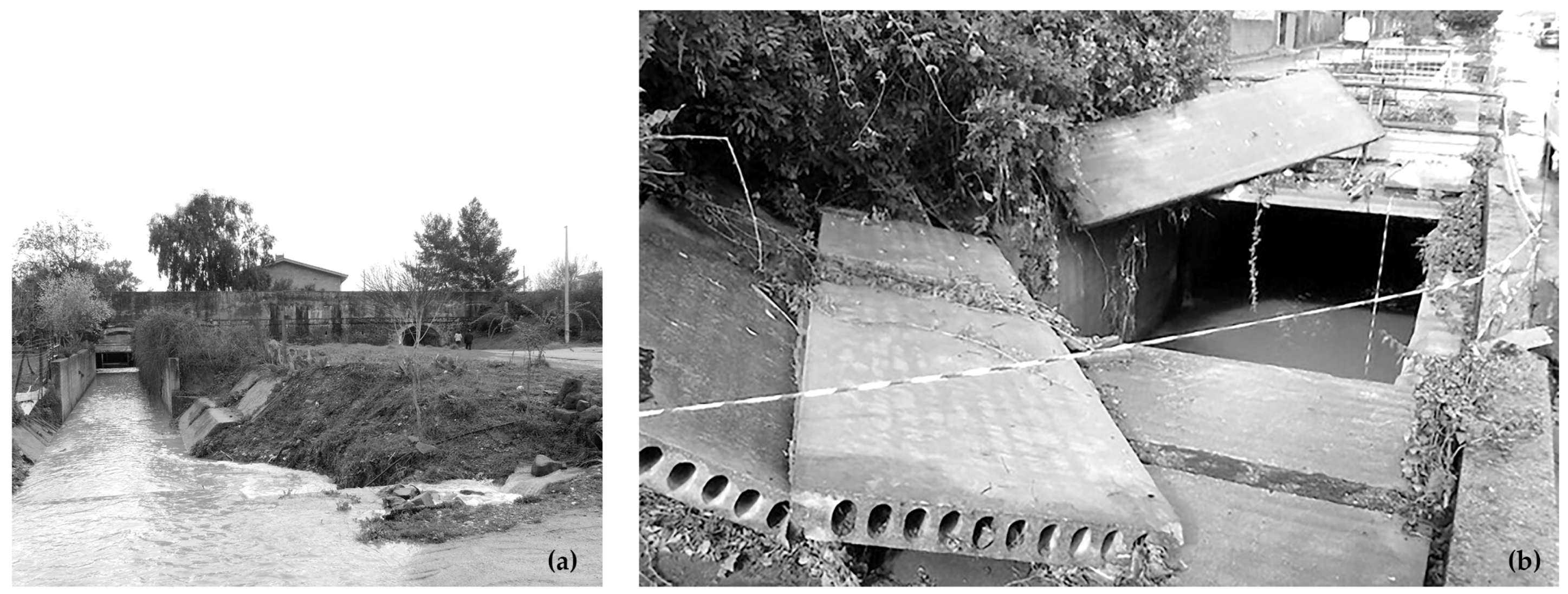
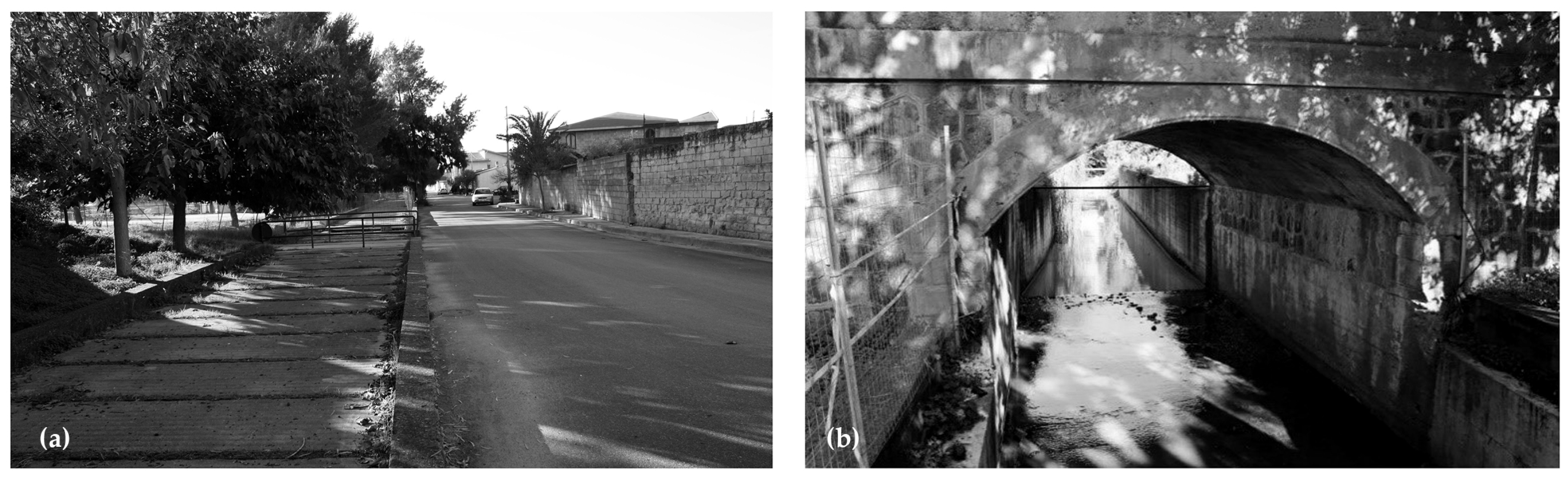
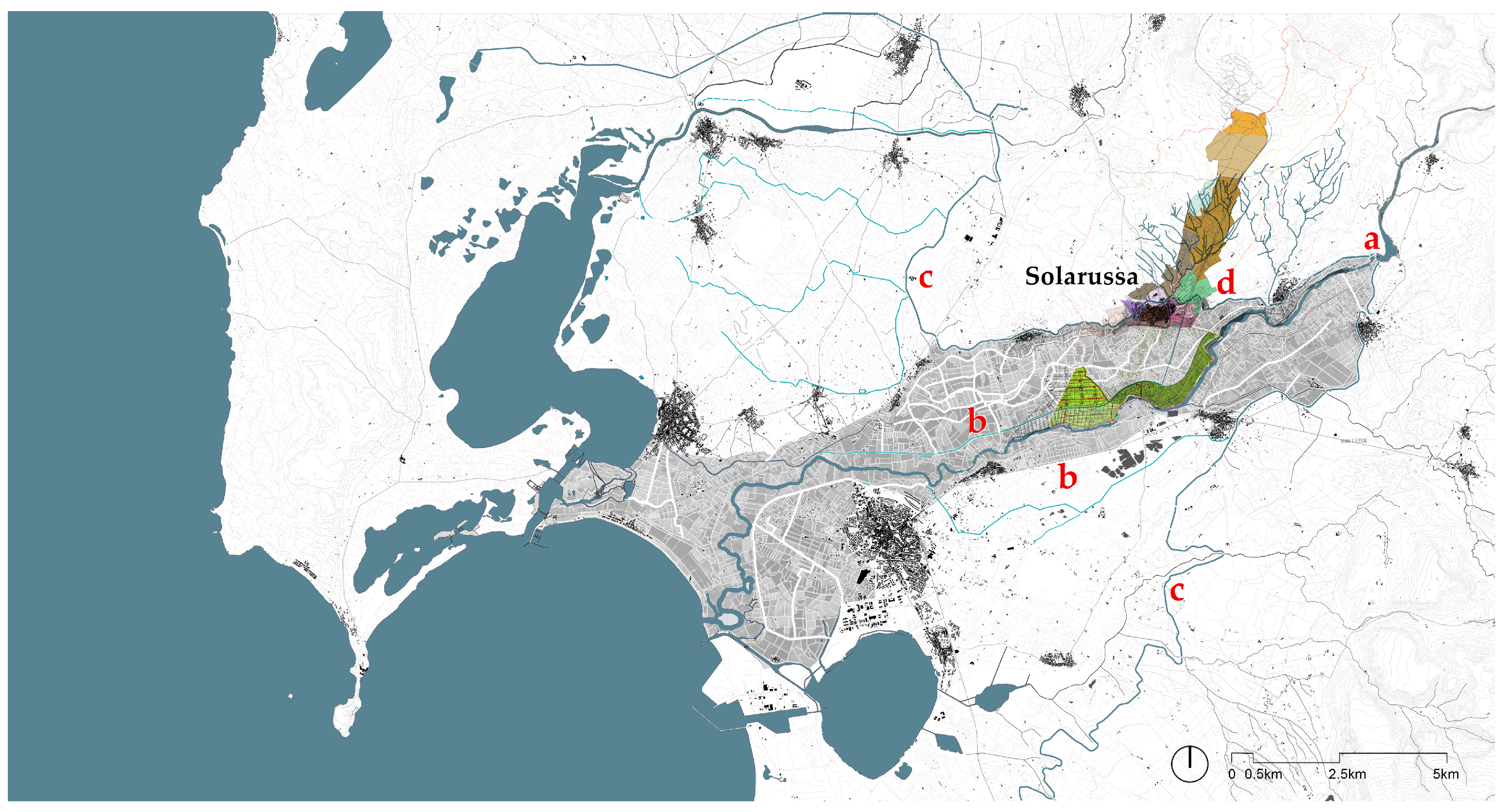
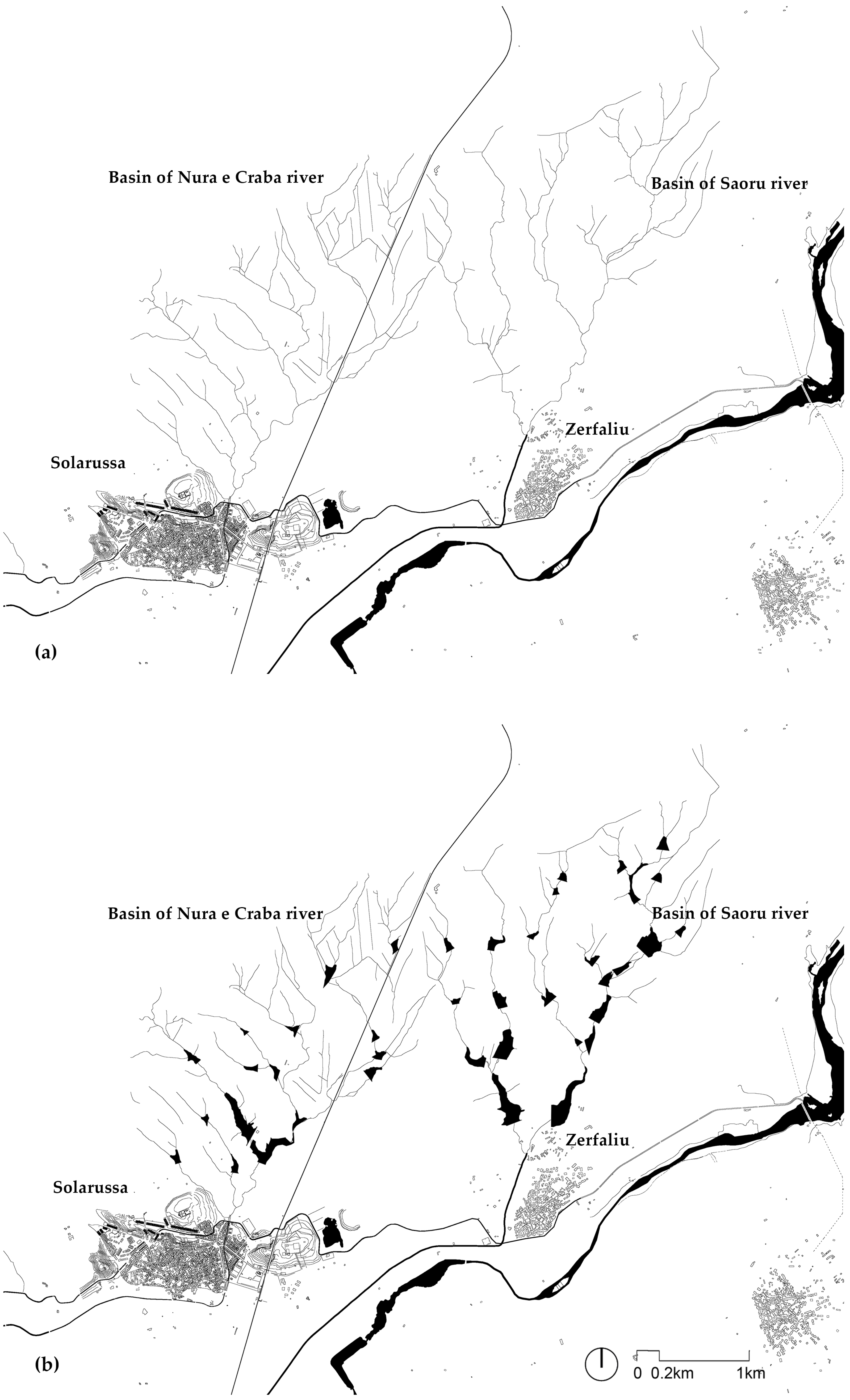
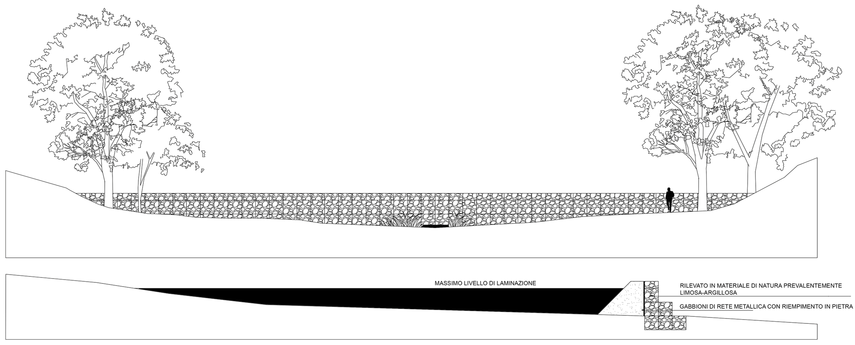
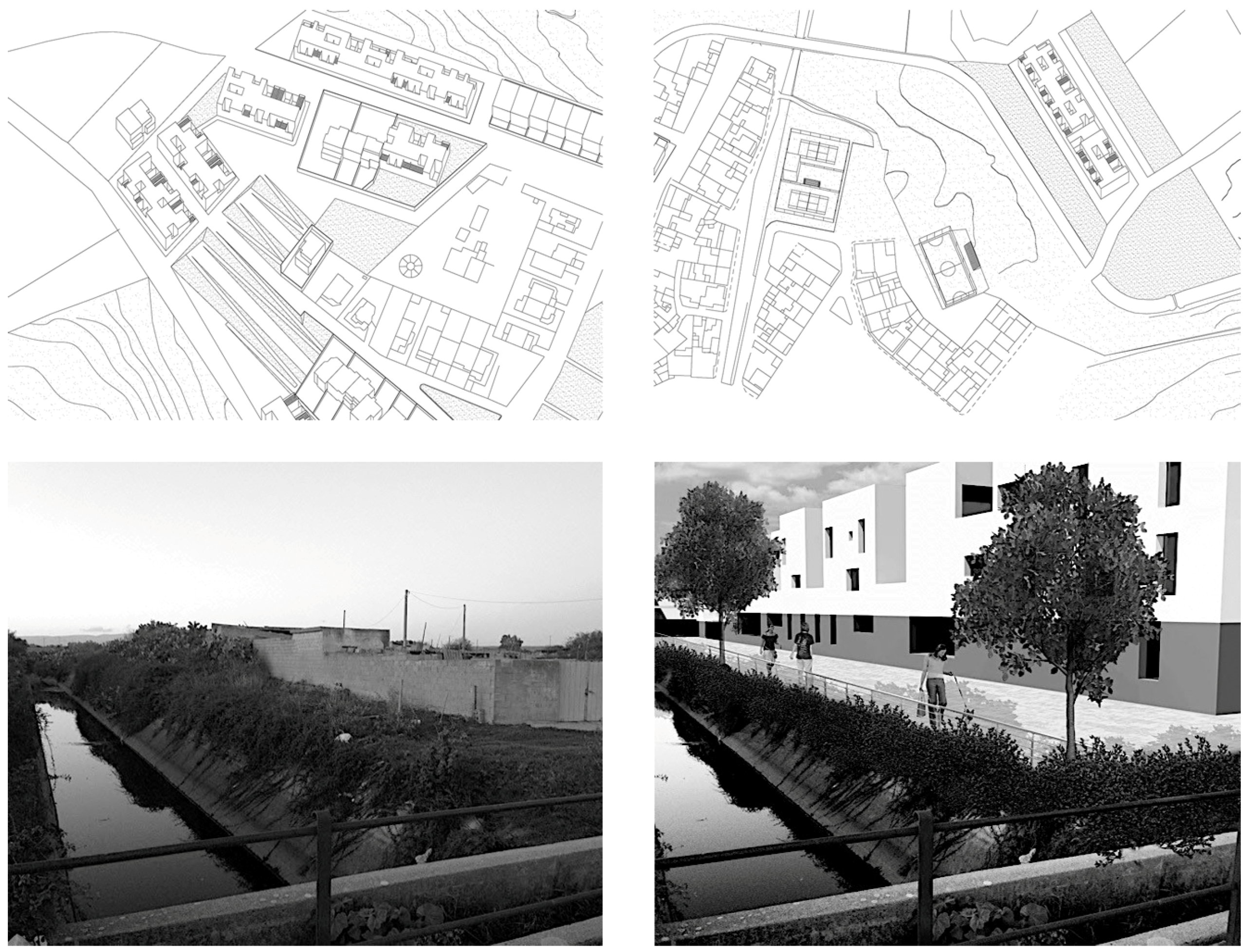
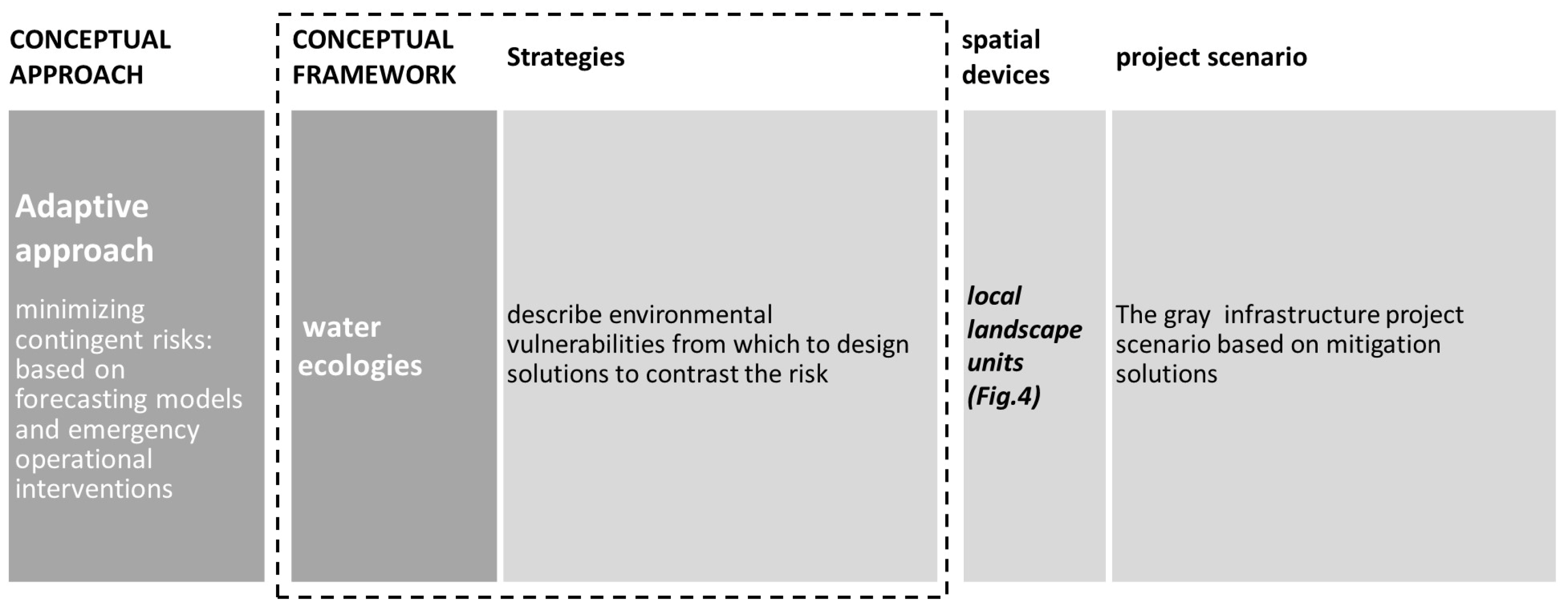
Table 1.
High flood discharge values of minor basins. Flow rate values in the downstream river basin section for flood return period of 50, 100, 200 and 500 years, for the Nura and Craba river and the Saoru river. Source: P. Scarteddu, Solarussa Urban Plan 2019.
Table 1.
High flood discharge values of minor basins. Flow rate values in the downstream river basin section for flood return period of 50, 100, 200 and 500 years, for the Nura and Craba river and the Saoru river. Source: P. Scarteddu, Solarussa Urban Plan 2019.
| Downstream River Basin Section | Q50 (m3/s) | Q100 (m3/s) | Q200 (m3/s) | Q500 (m3/s) |
|---|---|---|---|---|
| Nura e Craba river | 29.32 | 33.33 | 37.32 | 42.56 |
| Saoru river | 59.50 | 67.67 | 75.80 | 86.49 |
Publisher’s Note: MDPI stays neutral with regard to jurisdictional claims in published maps and institutional affiliations. |
© 2020 by the authors. Licensee MDPI, Basel, Switzerland. This article is an open access article distributed under the terms and conditions of the Creative Commons Attribution (CC BY) license (http://creativecommons.org/licenses/by/4.0/).
Share and Cite
MDPI and ACS Style
Sanna, G.; Serreli, S.; Biddau, G.M. Policies and Architectures for the Unthinkable Era: New Resilient Landscapes in Fragile Areas of Sardinia. Sustainability 2020, 12, 8714. https://doi.org/10.3390/su12208714
AMA Style
Sanna G, Serreli S, Biddau GM. Policies and Architectures for the Unthinkable Era: New Resilient Landscapes in Fragile Areas of Sardinia. Sustainability. 2020; 12(20):8714. https://doi.org/10.3390/su12208714
Chicago/Turabian StyleSanna, Gianfranco, Silvia Serreli, and Giovanni Maria Biddau. 2020. "Policies and Architectures for the Unthinkable Era: New Resilient Landscapes in Fragile Areas of Sardinia" Sustainability 12, no. 20: 8714. https://doi.org/10.3390/su12208714
Note that from the first issue of 2016, this journal uses article numbers instead of page numbers. See further details here.