The Contribution of Ecosystem Services in Developing Effective and Sustainable Management Practices in Marine Protected Areas. The Case Study of “Isola dell’Asinara”

Abstract
:1. Introduction
2. The Case Study
- To improve conservation and promotion of marine and costal zones and to direct public accessibility to natural sites.
- To improve the efficiency of planning and public governance of marine and coastal areas in the area of cooperation.
- To raise awareness on the economic value of the natural capital and to promote green and blue growth [44].
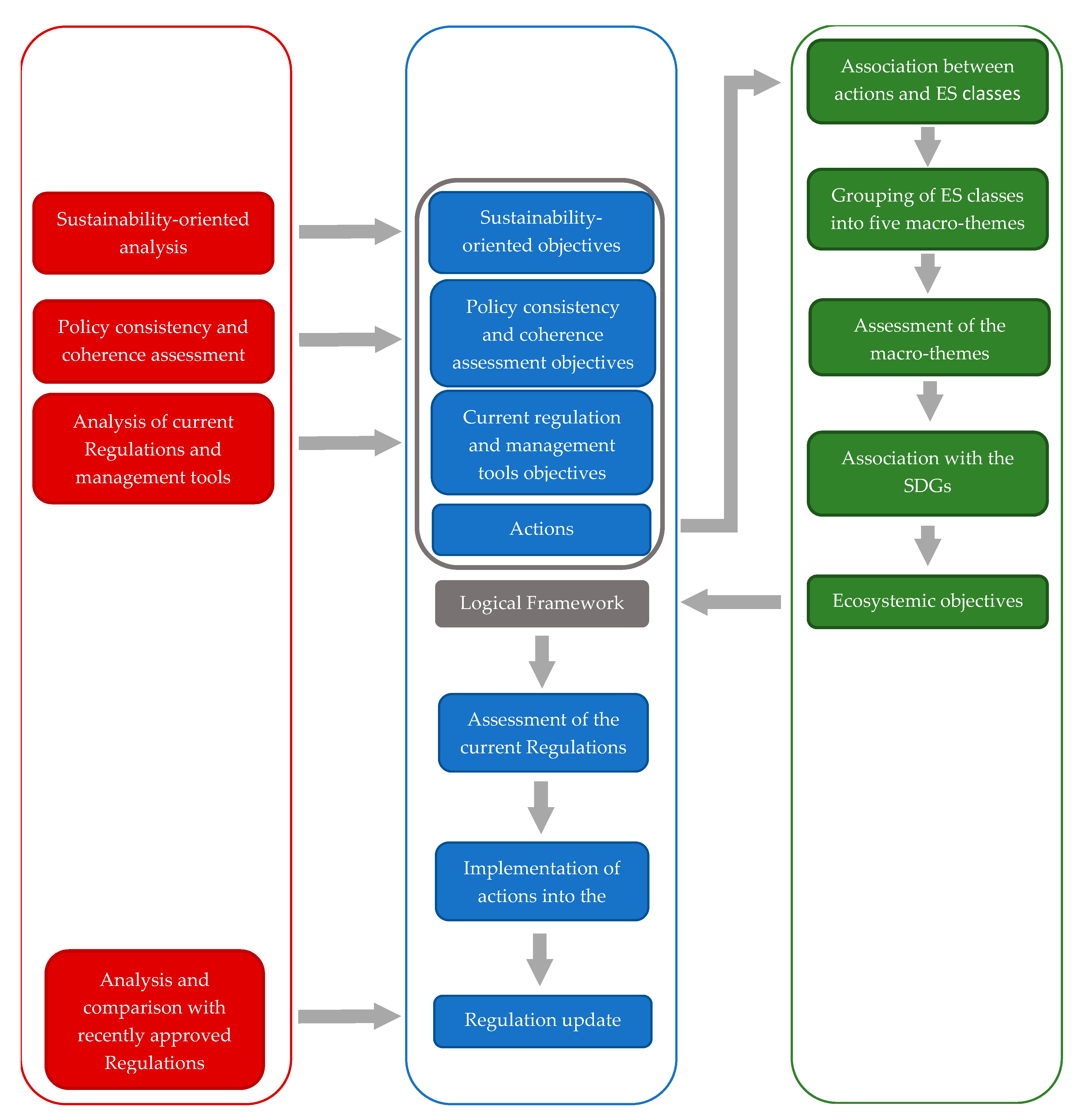
3. Methodology
The Construction of the Logical Framework
- Air;
- Water;
- Waste treatment;
- Soil and marine geo-morphology;
- Flora, fauna and biodiversity;
- Landscape;
- Settlement layout and functions;
- Tourism, recreation and outreach activities;
- Fishing and other production activities;
- Mobility and marine and terrestrial accessibility.
- To pursue general environmental enhancement, in relation to other zones and types of polluting substances;
- to integrate environmental needs in sectorial policies (especially in the sectors of energy, industry and transportation) with the aim of ensuring sustainable socio-economic development;
- to increase citizen awareness in order to promote environmentally friendly behavior;
- to integrate authorizations and inspection and monitoring activities in order to best ensure the implementation of the planning and regulation actions.
4. Definition of the PS Actions
- Dispositions and regulatory norms;
- monitoring;
- promotional, awareness-raising, information and educational programs;
- security and surveillance;
- institutional coordination.
Selection of Ecosystem Services for MPAs
- Provisioning services: Provision of genuine goods, such as food, water, timber, fiber, fuel and other raw materials, but also genetic material and ornamental species;
- regulation services: Regulation of climate, air quality and water, soil formation, pollination, waste assimilation, and mitigation of natural hazards such as erosion, weeds, etc.;
- cultural services: Non-material benefits such as heritage and cultural identity, spiritual enrichment and intellectual, aesthetic and recreational values.
- Terrestrial ES (cultivated crops, surface water for drinking, etc.) are out of the scope of this study;
- the MPA objectives focus more on biodiversity protection rather than on recreational functions and food productions (i.e., fishing).
- Tourism fruition and eco-tourism;
- fish biomass supply for business or entertainment purposes;
- climate regulation;
- water quality regulation;
- landscape and cultural heritage.
- Fish biomass supply for business or entertainment purposes;
- landscape fruition for recreational activities (bathing, diving and yachting) and scientific/educational purposes.
- Questionnaires to users (i.e., tourists and scuba divers);
- collection of information and documentation related to financial reports, studies and resource exploitation in the MPA headquarters. This part was conducted by the MPA staff in collaboration with the University of Genova;
- analysis of the documentation on the authorizations granted by the MPA in order to assess anthropic pressures and to gather information concerning the typology of the related operator or user;
- outline of a new authorization system for the simultaneous collection of information about the authorization-release procedure and of all the data needed for the application of the environmental accountability [63].
- Goal 7: Ensure access to affordable, reliable, sustainable and modern energy for all;
- Goal 13: Take urgent action to combat climate change and its impacts;
- Goal 14: Conserve and sustainably use the oceans, seas and marine resources for sustainable development.
5. Discussion
- The integration of the conservation measures provided in Natura 2000 management plans, and in the ICZM protocol and ISEA project into the regulations;
- the involvement and active participation of competent authorities, public bodies, stakeholders and experienced actors—who contributed to regulation improvement by virtue of their diverse needs and visions—which reflect the contrast between environmental protection and socio-economic development. It is important to underline that this moment is not for actors to passively approve decisions already taken according to a top-down approach, but it constitutes a valuable opportunity to share knowledge among stakeholders characterized by diverse backgrounds. It is during this phase that the PS process swings into action, by actually designing the new regulation proposal. Participation is essential to effectively integrate conservation measures and sectoral policies because norms are, in this way, assessed from a legislative point of view and interpreted in the light of their impacts on MPA users’ daily life. For this reason, participation is strongly encouraged from the very first steps of the PS definition process. Therefore, sharing is not limited only to results, but it also includes the working methodology.
- The overlapping of local, regional and national competencies. In particular, while the draft of the Natura 2000 management plans is produced by municipalities, their approval is entitled to regional administrations. Similarly, MPA regulations are proposed by the MPA authority, but they are approved by the MATTM. Interaction of diverse authorities complicates the process and entails numerous difficulties, such as the fragmentation and sectorization that characterize the planning and management tools in force;
- lack of operational objectives and actions in the regulations in force, which are able to adequately address a number of territorial problems and issues related to the allowed activities in the MPA. Response to this criticism is currently offered by the annual procedural guidelines, which establish detailed norms and operational conditions for the activities allowed in the MPA. In this sense, the regulation updating responds to the territorial problems and issues related to the allowed activities in the MPA by integrating the indications of the annual procedural guidelines into the new regulations.
- Acquisition of knowledge and awareness of ESs and of their potential contribution to human wellbeing. This is obtained through a set of objectives oriented to promote and protect the natural capital of the MPA by giving the regulation updating an ecosystem focus. In fact, it is fundamental to orient human actions to a sustainable use of ES in order to conserve their flows, especially considering that their economy relies on specific ESs (i.e., agriculture and fishing are strictly linked to provisioning ESs, tourism takes advantage of cultural ESs, etc.). With reference to this, “ecosystemic objectives” are defined on the basis of ES and are contextualized in the area of the case study coherently with the regulation actions defined in the PS. This represents the pivotal element for the regulation process to update coherently with the EU guidelines regarding ESs. In particular, with regard to the ES “climate regulation”, it was necessary to define a corresponding objective aiming at integrating measures to combat climate change into the regulations. This aspect was totally absent in the existing regulations; thus, it represents an innovation with respect to the “traditional” issues that arose during the implementation of the PS;
- the formulation of a set of ecosystemic objectives and actions in coherence with Agenda 2030 objectives. This connection allowed addressing the existing objectives to specific future challenges (as in the case of objectives related to fishing in light of Objective 14 of Agenda 2030 and the fish biomass supply for business or entertainment purposes).
6. Conclusions and Suggestions for Further Research
- The definition of a monitoring system related to the regulation implementation, in order to assess the impacts of the coastal ecosystem management on ESs;
- ES measurement through adequate accountability and statistical methods to support the decisional process. Indeed, notwithstanding their fundamental role for socio-economic development, the importance of ecosystems for human wellbeing is currently not adequately evaluated, especially at planning and regulation levels [65]. Indeed, ecosystems provide vital support to life quality, and their functions and services can be assessed in monetary terms thus including the value of natural capital in resource management and spatial planning. ES assessment should take into account ecosystem mapping, anthropic pressures that threaten them and interactions between natural capital and its potential in terms of ES provision. This requires the definition of a set of adequate and representative indicators [66];
- ES monetary assessment. In this sense, it is necessary to re-consider the whole management process in order to identify and highlight ES value, and to understand the role of their safeguarding in influencing their quality and quantity in relation to an improvement of the natural capital [22], and also in economic terms;
- the introduction of an evaluation procedure for the MPA regulations. The proposed PS stresses the significative impacts of the regulations on the environment and formulates an innovative approach, inspired by SEA principles and methodology, which allows the inclusion of environmental objectives into the decisional process.
Author Contributions
Funding
Acknowledgments
Conflicts of Interest
References
- Agardy, T. Information needs for marine protected areas: Scientific and societal. BMS 2000, 66, 875–888. [Google Scholar] [CrossRef]
- Agardy, T.; Alder, J.; Dayton, P.; Curran, S.; Kitchingman, A.; Wilson, M.; Catenazzi, A.; Restrepo, J.; Birkeland, C.; Blaber, S.; et al. Coastal System. In Current State and Trends; Global Assessment reports; Island Press: Washington, DC, USA, 2005; Chapter 19; Volume 1, pp. 513–549. [Google Scholar]
- Arkema, K.K.; Guannel, G.; Verutes, G.; Wood, S.A.; Guerry, A.; Ruckelshaus, M.; Kareiva, P.; Lacayo, M.; Silver, J.M.; Lacayo-Emery, M. Coastal habitats shield people and property from sea-level rise and storms. Nat. Clim. Chang. 2013, 3, 913–918. [Google Scholar] [CrossRef]
- Australian Government. The Logical Framework Approach, AusGUIDElines, AusAID; AusAID: Canberra, Australia, 2000.
- Bonvoisin, N. Decision-Making for Sustainable Development: How Assessment Can Help. Available online: https://www.unece.org/fileadmin/DAM/oes/nutshell/2009/6_SusDev.EIA.pdf (accessed on 4 October 2019).
- Borja, A. Grand challenges in marine ecosystems ecology. Front. Mar. Sci. 2014, 1, 1. [Google Scholar] [CrossRef] [Green Version]
- Blackman, R. Project Cycle Management; Tearfund: Teddington, UK, 2003. [Google Scholar]
- Brown, A.L.; Thérivel, R. Principles to Guide the Development of Strategic Environmental Assessment Methodology. Impact Assess. Proj. Apprais. 2012, 18, 183–189. [Google Scholar] [CrossRef] [Green Version]
- Bussi, F. Progettare in Partenariato. Guida Alla Conduzione di Gruppi di Lavoro Con il Metodo GOPP; Franco Angeli: Milano, Italy, 2001. [Google Scholar]
- Cattaneo Vietti, R.; Tunesi, L. Le aree marine protette in Italia; Problemi e prospettive: Aracne, Roma, 2007; Available online: http://www.aracneeditrice.it/pdf/9788854814363.pdf (accessed on 26 November 2019).
- Cicin-Sain, B.; Belfiore, S. Linking marine protected areas to integrated coastal and ocean management: A review of theory and practice. Ocean Coast. Manag. 2005, 48, 847–868. [Google Scholar] [CrossRef]
- Cicin-Sain, B.; Knecht, R.W.; Vallega, A.; Harakunarak, A. Education and training in integrated coastal management: Lessons from the international arena. Ocean Coast. Manag. 2000, 43, 291–330. [Google Scholar] [CrossRef]
- Comitato per il Capitale Naturale, Secondo rapporto sullo stato del capitale naturale in Italia, 2018. Available online: https://www.minambiente.it/sites/default/files/archivio/allegati/sviluppo_sostenibile/II_Rapporto_Stato_CN_2018_2.pdf (accessed on 29 November 2019).
- Devuyst, D.; Hens, L.; De Lannoy, W. Chapter 5: Linking Impact Assessment with Sustainable Development and the Introduction of Strategic Environmental Assessment. In How Green Is the City? Columbia University Press: New York, NY, USA, 2001. [Google Scholar]
- European Commission; DG XI Environment, Nuclear Safety and Civil Protection. A Handbook on Environmental Assessment of Regional Development Plans and EU Structural Funds Programmes; Environmental Resources Management: London, UK, 1998; Available online: http://ec.europa.eu/environment/archives/eia/sea-guidelines/handbook.htm (accessed on 2 December 2019).
- European Commission. Directive 2008/56/EC of the European Parliament and of the Council. Available online: https://eur-lex.europa.eu/legal-content/EN/TXT/PDF/?uri=CELEX:32008L0056&from=EN (accessed on 10 November 2019).
- European Commission. Report from the Commission to the European Parliament and the Council on the progress in establishing marine protected areas (as required by Article 21 of the Marine Strategy Framework Directive 2008/56/EC). Brussels, 1/10/2015. Available online: https://ec.europa.eu/transparency/regdoc/rep/1/2015/EN/1-2015-481-EN-F1-1.PDF (accessed on 25 September 2019).
- European Environmental Agency. Marine Protected Areas. Available online: https://www.eea.europa.eu/themes/water/europes-seas-and-coasts/assessments/marine-protected-areas (accessed on 25 September 2019).
- European Environment Agency. Marine environment. Available online: https://www.eea.europa.eu/soer-2015/europe/marine-and-coastal#note21 (accessed on 25 September 2019).
- European Union. 2012. Blue Growth. Opportunities for Marine and Maritime Sustainable Growth. Available online: https://ec.europa.eu/maritimeaffairs/sites/maritimeaffairs/files/docs/publications/blue-growth_en.pdf (accessed on 10 November 2019).
- European Union. Directive 2014/89/Eu of the European Parliament and of the Council. Available online: https://eur-lex.europa.eu/legal-content/EN/TXT/PDF/?uri=CELEX:32014L0089&from=EN (accessed on 10 November 2019).
- Federparchi, Contabilità ambientale nelle Aree Marine Protette Italiane. Idea progettuale, 2014. Available online: http://www.torredelcerrano.it/wp-content/uploads/2016/11/2_Documento-Contabilit%C3%A0_ambientale_FEDERPARCHI-Roma-15-aprile-2014.pdf (accessed on 23 November 2019).
- Fernandes, L.; Day, J.; Lewis, A.; Slegers, S.; Kerrigan, B.; Breen, D.; Cameron, D.; Jago, B.; Hall, J.; Lowe, D.; et al. Establishing representative no-take areas in the Great Barrier Reef: Large-scale implementation of theory on Marine Protected Areas. Conserv. Biol. 2005, 19, 1733–1744. [Google Scholar] [CrossRef]
- Fischer, T.B. Towards a more Systematic Approach to Policy, Plan and Programme Environmental Assessment—Some Evidence from Europe. In SEA in Australasia; Marsden, S., Dovers, S., Eds.; Sydney Place Federation Press: Sydney, Australia, 2002. [Google Scholar]
- Gaston, K.J.; Pressey, R.L.; Margules, C.R. Persistence and vulnerability: Retaining biodiversity in the landscape and in protected areas. J. Biosci. 2002, 27, 361–384. [Google Scholar] [CrossRef] [PubMed]
- GIREPAM, Gestione Integrata delle Reti Ecologiche attraverso i Parchi e le Aree Marine. Il progetto, n.d. Available online: http://interreg-maritime.eu/it/web/girepam/checosarealizza (accessed on 10 November 2019).
- Gomes, I.; Pérez-Jorge, S.; Peteiro, L.; Andrade, J.; Bueno-Pardo, J.; Quintino, V.; Rodrigues, A.M.; Azevedo, M.; Vanreusel, A.; Queiroga, H.; et al. Marine biological value along the Portuguese continental shelf; insights into current conservation and management tools. Ecol. Indic. 2018, 93, 533–546. [Google Scholar] [CrossRef]
- Groves, C.R. Drafting a Conservation Blueprint: A Practitioner’s Guide to Planning for Biodiversity; Island Press: Washington, DC, USA, 2003. [Google Scholar]
- Groom, M.J.; Vynne, C.H. Habitat Degradation and Loss. In Principles of Conservation Biology, 3rd ed.; Groom, M.J., Meffe, G.K., Carroll, C.R., Eds.; Sinauer Associates, Inc.: Sunderland, MA, USA, 2012; pp. 173–212. [Google Scholar]
- Gurrutxaga San Vicente, M.; Lozano Valencia, P. La Integración de la Conectividad Ecológica en los Instrumentos de Ordenación y Planificación Territorial: Una Revision; Boletín de la A.G.E.: Madrid, Spain, 2019; n. 49; pp. 45–66. [Google Scholar]
- Henson, S.A.; Beaulieu, C.; Ilyina, T.; John, J.G.; Long, M.; Seferian, R.; Tjiputra, J.; Sarmiento, J.L. Rapid emergence of climate change in environmental drivers of marine ecosystems. Nat. Commun. 2017, 8, 14682. [Google Scholar] [CrossRef]
- Hilborn, R. The role of science in MPA establishment in California: A personal perspective. Environ. Conserv. 2012, 39, 195–198. [Google Scholar] [CrossRef]
- Interreg. Il Programma Italia-Francia Marittimo. Available online: http://interreg-maritime.eu/it/programma (accessed on 10 November 2019).
- IPBES (Intergovernmental Science-Policy Platform on Biodiversity and Ecosystem Services). The IPBES Regional Assessment Report on Biodiversity and Ecosystem Services for the Americas; Rice, J., Seixas, C.S., Zaccagnini, M.E., Bedoya-Gaitán, M., Valderrama, N., Eds.; IPBES: Bonn, Germany, 2018; 656p. [Google Scholar]
- IPCC (Intergovernmental Panel on Climate Change). Climate Change 2001: The Scientific Basis. Contribution of Working Group I to the Third Assessment Report; Houghton, J.T., Ding, Y., Griggs, D.J., Noguer, M., Van der Linden, P.J., Dai, X., Maskell, K., Johnson, C.A., Eds.; Cambridge University Press: Cambridge, UK, 2003. [Google Scholar]
- Italian Official Gazette. Regolamento di Esecuzione ed Organizzazione Dell’area Marina Protetta “Isola dell’Asinara. Available online: www.parcoasinara.org/it/contenuti/articoli/dettagli/553/ (accessed on 29 January 2020).
- Jameson, S.C.; Tupper, M.H.; Ridley, J.M. The three screen doors: Can marine “protected” areas be effective? Mar. Pollut. Bull. 2002, 44, 1177–1183. [Google Scholar] [CrossRef]
- Jentoft, S.; Chuenpagdee, R.; Pascual-Fernández, J.J. What are MPAs for: On goal formation and displacement. Ocean Coast. Manag. 2011, 54, 75–83. [Google Scholar] [CrossRef]
- Jones, P.J. A review and analysis of the objectives of marine nature reserves. Ocean Coast. Manag. 1994, 24, 149–178. [Google Scholar] [CrossRef]
- Kaiser, M.J. Are marine protected areas a red herring or fisheries panacea? Can. J. Fish. Aquat. Sci. 2005, 62, 1194–1199. [Google Scholar] [CrossRef]
- Kajanus, M.; Leskinen, P.; Kurttila, M.; Kangas, J. Making use of MCDS methods in SWOT analysis—Lessons learnt in strategic natural resources management. For. Policy Econ. 2012, 20, 1–9. [Google Scholar] [CrossRef]
- Kelleher, G. Guidelines for Marine Protected Areas; International Union for the Conservation of Nature: Gland, Switzerland, 1999. [Google Scholar]
- Kørnøv, L.; Thissen, W. Rationality in Decision- and Policy-Making: Implications for Strategic Environmental Assessment. Impact Assess. Proj. Apprais. 2012, 18, 191–200. [Google Scholar] [CrossRef]
- Leone, F.; Zoppi, C. Conflictual Issues Concerning Land Uses Related to Ecosystem Services under the Provisions of the Habitats and Birds Directives. Available online: http://www.input2016.it/conference_2016/conference_proceedings (accessed on 29 January 2020).
- Linee Guida per la Valutazione ambientale strategica dei Piani urbanistici comunali [Guidelines Manual on Strategic Environmental Assessment of Municipal Masterplans], Annex to the Decision of the Regional Government of Sardinia n. 44/51 of 14 December 2010. Available online: http://www.sardegnaambiente.it/documenti/18_269_20110203150553.pdf (accessed on 2 December 2019).
- Lundquist, C.J.; Granek, E.F. Strategies for Successful Marine Conservation: Integrating Socioeconomic, Political, and Scientific Factors. Conserv. Boil. 2005, 19, 1771–1778. [Google Scholar] [CrossRef]
- Margules, C.R.; Pressey, R.L. Systematic conservation planning. Nature 2000, 405, 243–253. [Google Scholar] [CrossRef]
- Povero, P.; Vassallo, P.; Paoli, C.; Dapueto, G.; Massa, F.; Pozzi, M.; Armenio, M.; Rigo, I.; Congiatu, P.; Gazale, V.; et al. Contabilità Ambientale nelle Aree Marine Protette Italiane. Ecorendiconto dell’Isola dell’Asinara; Report finale; Parco Nazionale dell’Asinara, CoNISMa: Genova, Italy, 2018. [Google Scholar]
- Marino, D. Le aree marine protette italiane. Stato, politiche, governance; Franco Angeli: Milano, Itlay, 2011. [Google Scholar]
- ME (Millennium Ecosystem Assessment), Ecosystems and Human Well-being. A Framework to Assessment, Island Press, 2003. Available online: http://pdf.wri.org/ecosystems_human_wellbeing.pdf (accessed on 13 November 2019).
- Ministero dell’Ambiente, della Tutela del Territorio e del Mare (MATTM). Studio e analisi delle forme di coesistenza e criticità tra sviluppo economico- sociale e conservazione della natura. Il ruolo dei processi partecipati. Verso la strategia nazionale per la biodiversità, 2018. Available online: https://www.minambiente.it/sites/default/files/archivio/biblioteca/dpn_tavolo1_partecipazione.pdf (accessed on 29 November 2019).
- Murray, S.N.; Ambrose, R.F.; Bohnsack, J.A.; Botsford, L.W.; Carr, M.H.; Davis, G.E.; Dayton, P.K.; Gotshall, D.; Gunderson, D.R.; Hixon, M.A.; et al. No-take Reserve Networks: Sustaining Fishery Populations and Marine Ecosystems. Fisheries 1999, 24, 11–25. [Google Scholar] [CrossRef]
- Navarro Ortega, A. Las áreas marinas protegidas: ¿Un instrumento para la gestión eficiente del medio marino en España? In Proceedings of the III Congresso Internacional do Mar “A Proteção do Ambiente Costeiroe Marinho”, Universidade Lusíada, Lisboa, Portugal, May 2014. [Google Scholar]
- Nobre, A.M.; Ferreira, J.G. Integration of ecosystem-based tools to support coastal zone management. JCR 2009, SI 56, 1676–1680. [Google Scholar]
- Norse, E.A. Global Marine Biological Diversity: A Strategy for Building Conservation into Decision Making; Island Press: Washington, DC, USA, 1993; pp. 3–9. [Google Scholar]
- Paoli, C.; Povero, P.; Burgos, E.; Dapueto, G.; Fanciulli, G.; Massa, F.; Scarpellini, P.; Vassallo, P. Natural capital and environmental flows assessment in marine protected areas: The case study of Liguria region (NW Mediterranean Sea). Ecol. Model. 2018, 368, 121–135. [Google Scholar] [CrossRef]
- Parco Asinara. Aspetti Storico-Geografici. Available online: http://www.parcoasinara.org/it/contenuti/articoli/dettagli/544/ (accessed on 12 November 2019).
- Parco Asinara. Contenuti. Available online: http://www.parcoasinara.org/it/contenuti/articoli/dettagli/512/ (accessed on 12 November 2019).
- Parsons, T.R. Biological coastal communities: Productivity and impacts, in Coastal systems studies and sustainable development. UNESCO TPMS 1992, 64, 27–37. [Google Scholar]
- Partidärio, M.R. Strategic environmental assessment: Key issues emerging from recent practice. Environ. Impact Assess. Rev. 1996, 16, 31–55. [Google Scholar] [CrossRef]
- Potts, T.; Burdon, D.; Jackson, E.; Atkins, J.; Saunders, J.; Hastings, E.; Langmead, O. Do marine protected areas deliver flows of ecosystem services to support human welfare? Mar. Policy 2014, 44, 139–148. [Google Scholar] [CrossRef] [Green Version]
- Rogers, A.; Sumaila, U.; Hussain, S.; Baulcomb, C. The High Seas and Us: Understanding the Value of High-Seas Ecosystems; Report 2014; Global Ocean Commission: Oxford, UK, 2014. [Google Scholar]
- Sadler, B.; Verheem, R. Strategic Environmental Assessment—Status, Challenges and Future Directions; Ministry of Housing, Spatial Planning and the Environment: The Hague, The Netherlands, 1996. [Google Scholar]
- Salm, R.V.; Clark, J.R. Marine and Coastal Protected Areas: A Guide for Planners and Managers; IUCN: Gland, Switzerland, 2000. [Google Scholar]
- Scott, J.M.; Davis, F.W.; McGhie, R.G.; Wright, R.G.; Groves, C.; Estes, J. Nature reserves: Do they capture the full range of America’s biological diversity? EA 2001, 11, 999–1007. [Google Scholar] [CrossRef]
- Sheate, W.R.; Dagg, S.; Richardson, J.; Aschemann, R.; Palerm, J.; Steen, U. Integrating the environment into strategic decision-making: Conceptualizing policy SEA. Eur. Environ. 2003, 13, 1–18. [Google Scholar] [CrossRef]
- Smith, V.; Tilman, G.; Nekola, J. Eutrophication: Impacts of excess nutrient inputs on freshwater, marine, and terrestrial ecosystems. Environ. Pollut. 1999, 100, 179–196. [Google Scholar] [CrossRef]
- Zoppi, C. Integration of Conservation Measures Concerning Natura 2000 Sites into Marine Protected Areas Regulations: A Study Related to Sardinia. Sustainability 2018, 10, 3460. [Google Scholar] [CrossRef]


| Environmental Component K | |
| The introduction qualitatively describes the environmental component K in the analyzed territorial context (i.e., air). The description is organized according to themes (i.e., air quality, meteorological conditions), which are in turn articulated in specific aspects (i.e., source of pollution, temperature, annual precipitation, etc.). The latter provide a quantitative analysis based on appropriate indicators. | |
| Theme n | |
| This section provides a brief qualitative description of the theme n, which refers to the environmental component K. | |
| Specific aspect t | |
| Brief description of the aspect through its distinguishing elements such as legislative and management tools, operational tools, thematic maps, infrastructure, etc. | |
| Indicator 1 [unit] | Notes |
| … | |
| Indicator n [unit] | |
| Source: … Year: … | |
| SWOT Analysis | |
| Strengths | Weaknesses |
| … | … |
| Opportunities | Threats |
| … | … |
| Sustainability-oriented Objectives | Environmental sustainability criteria |
| Ps_Ob_SA_n … | … |
| SWOT Analysis | |
|---|---|
| Strengths | Weaknesses |
| — Absence of air pollution sources within the MPA. |
|
| Opportunities | Threats |
| — Favorable meteorological conditions during the summer period, and mild weather during the winter. | — Presence of pollution sources near the MPA, namely the Porto Torres industrial area and Fiume Santo power station. |
| Sustainability-oriented Objective | Environmental sustainability criteria |
| — To enhance air quality by reducing the pollution consequences in order to mitigate negative effects caused by climate change. | i, ii, iii, vii, viii |
| Sustainability-Oriented Objectives | Policy Consistency and Coherence Objectives | Regulation Objectives (Specific Objectives) |
|---|---|---|
| Ps_Ob_SA_1 To enhance air quality by reducing pollution consequences, in order to mitigate the negative effects caused by climate change. | Ps_Ob_CE_4 To increase citizen awareness in order to promote environmentally friendly behaviors. | PS_Ob_REO_10 To organize information, promotional, awareness-raising and educational programs in order to guarantee sustainable fruition of the area and of its natural resources. |
| PS_Ob_REO_11 To promote the development of economic, social, cultural and tourist activities, which are compatible with conservation needs. | ||
| PS_Ob_REO_12 To promote programs and projects directed to the enhancement of marine ecosystems. | ||
| PS_Ob_REO_16 To ensure efficiency in the integrated management of the MPAs. | ||
| Ps_Ob_CE_5 To monitor natural phenomena and processes in order to support authorization and control procedures for a better implementation of the regulation actions. | PS_Ob_REO_18 To efficiently organize surveillance and assistance activities. | |
| PS_Ob_REO_19 To promote scientific investigation programs. | ||
| PS_Ob_REO_20 To monitor the state of conservation of habitats and species. | ||
| Ps_Ob_CE_11 To integrate sustainable development policies, in order to reduce and prevent climate change and desertification impacts, by reducing the emission of climate-changing gas. | PS_Ob_REO_8 To efficiently organize recreational boat activities, mooring and docking, in compliance with the rules in force in each zone of the MPA and with the related Code of Conduct. | |
| PS_Ob_REO_13 To reduce the main anthropic pressure factors. | ||
| PS_Ob_REO_16 To ensure efficiency in the integrated management of the MPAs. | ||
| Ps_Ob_CE_13 To increase knowledge, applied research and experimentation. | PS_Ob_REO_19 To promote scientific investigation programs. | |
| Ps_Ob_CE_16 To reduce energy consumption, pollutant emissions and their impacts on the MPA territory, landscape and environmental value. | PS_Ob_REO_8 To efficiently organize recreational boat navigation, mooring and docking, in compliance with the rules in force in each zone of the MPA and with the related code of conduct. | |
| PS_Ob_REO_13 To reduce the main anthropic pressure factors. |
| Sustainability-Oriented Objectives | Regulation Objectives (Specific Objectives) | Regulation Actions |
|---|---|---|
| Ps_Ob_SA_1 To enhance air quality by reducing pollution consequences, in order to mitigate the negative effects caused by climate change. | Ps_Ob_REO_11, Ps_Ob_REO_13 | Act_REO_3 Positioning of landing stages and buoys for the mooring of recreational boats in proximity of the Asinara island, in order to preserve Posidonia oceanica habitats. |
| Ps_Ob_REO_11, Ps_Ob_REO_13 | Act_REO_4 Realization of artificial submerged barriers in order to constrict illegal trawling and to protect Posidonia oceanica meadows. | |
| Ps_Ob_REO_12 | Act_REO_6 To elaborate strategies and programs for the sustainable use of the MPA territory. | |
| Ps_Ob_REO_18 | Act_REO_7 To adopt measures to facilitate the rescue of animals in distress or disoriented. | |
| Ps_Ob_REO_10 | Act_REO_8 To regulate photo shoots, filming and TV recordings. | |
| Ps_Ob_REO_8, Ps_Ob_REO_10, Ps_Ob_REO_13 | Act_REO_11 To regulate activities allowed in each MPA zone. | |
| Ps_Ob_REO_10, Ps_Ob_REO_13 | Act_REO_12 To organize the tourism fruition system within the MPA. | |
| Ps_Ob_REO_8 | Act_REO_13 To control and limit ship and boat speed, in order to reduce underwater noise pollution and the risk of collision with cetaceans and turtles. | |
| Ps_Ob_REO_20 | Act_REO_14 To regulate monitoring activity. | |
| Ps_Ob_REO_10, Ps_Ob_REO_13 | Act_REO_18 To design and create submarine paths. | |
| Ps_Ob_REO_12 | Act_REO_19 To launch seabed cleaning campaigns. | |
| Ps_Ob_REO_19 | Act_REO_20 To regulate technical and scientific research activity. | |
| Ps_Ob_REO_13 | Act_REO_21 To regulate bathing and swimming. | |
| Ps_Ob_REO_8 | Act_REO_24 To regulate recreational boat activities. | |
| Ps_Ob_REO_8 | Act_REO_25 To regulate docking of recreational boats. | |
| Ps_Ob_REO_8 | Act_REO_26 To regulate mooring of recreational boats. | |
| Ps_Ob_REO_11 | Act_REO_31 To regulate chartering and leasing—even temporary—of recreational boats. | |
| Ps_Ob_REO_11, Ps_Ob_REO_13 | Act_REO_33 To define a set of indicators to asses carrying capacity of the MPA during the summer. | |
| Ps_Ob_REO_11 | Act_REO_34 To regulate authorizations for the development of socio-economic, tourist, social and cultural activities within the MPA. | |
| Ps_Ob_REO_11 | Act_REO_35 To adopt measures to preserve and protect the archaeologic, historic and cultural submarine heritage. | |
| Ps_Ob_REO_8 | Act_REO_41 To systematize the mooring infrastructure. | |
| Ps_Ob_REO_20 | Act_REO_42 To launch monitoring campaigns to collect data on air quality. |
| Title | ||||||
|---|---|---|---|---|---|---|
| Regulations in Force | First Assessment Level: Comparison between Actions and Articles of Regulations in Force | Second Assessment Level: Comparison with Recently Approved Regulations | Regulation Update | |||
| Article from Regulations in Force | Article of the Updated Regulations | |||||
| Subsection | Action | Article/action assessment | Remarks about the article/action assessment | Recent approved regulations | Remarks about the comparison with recent approved regulations | New subsection proposal |
| Code | Action |
|---|---|
| Action category: DISPOSITIONS AND REGULATORY NORMS | |
| ACT_Reg_1 | To adopt protection and conservation measures for habitats and species. |
| ACT_Reg_2 | To regulate the management of stranded Posidonia oceanica. |
| ACT_Reg_3 | Positioning of landing stages of buoys for the mooring of recreational boats in proximity of the Asinara island in order to preserve Posidonia oceanica habitats. |
| ACT_Reg_4 | Realization of artificial submerged barriers in order to constrict illegal trawling and to protect Posidonia oceanica meadows. |
| ACT_Reg_5 | To adopt measures to prevent coastal erosion. |
| ACT_Reg_6 | To elaborate strategies and programs for the sustainable use of the MPA territory. |
| ACT_Reg_7 | To adopt measures to facilitate the rescue of animals in distress or disoriented. |
| ACT_Reg_8 | To regulate photo shoots, filming and TV recordings. |
| ACT_Reg_9 | To launch recovery campaigns of abandoned waste and of the polluted areas of the MPA. |
| ACT_Reg_10 | To launch eradication campaigns of all invasive or potential invasive alien plants. |
| ACT_Reg_11 | To regulate activities allowed in each MPA zone. |
| ACT_Reg_12 | To organize the tourism fruition system within the MPA. |
| ACT_Reg_13 | To control and limit ship and boat speed, in order to reduce underwater noise pollution and the risk of collision with cetaceans and turtles. |
| ACT_Reg_14 | To regulate monitoring activities. |
| ACT_Reg_15 | To define identification criteria of fishing gear hallmarking. |
| ACT_Reg_16 | To define a plan for the recovery of ghost fishing gear. |
| ACT_Reg_17 | To adopt adequate measures to rehabilitate dunes and bars (protection, signage and maintenance). |
| ACT_Reg_18 | To design and create submarine paths. |
| ACT_Reg_19 | To launch seabed cleaning campaigns. |
| ACT_Reg_20 | To regulate technical and scientific research activity. |
| ACT_Reg_21 | To regulate bathing and swimming. |
| ACT_Reg_22 | To regulate guided scuba diving tours. |
| ACT_Reg_23 | To regulate sea-watching activities. |
| ACT_Reg_24 | To regulate recreational boat activities. |
| ACT_Reg_25 | To regulate docking of recreational boats. |
| ACT_Reg_26 | To regulate mooring of recreational boats. |
| ACT_Reg_27 | To regulate activities of public passenger transport services, sailboat charters and guided tours. |
| ACT_Reg_28 | To regulate professional fishing activities. |
| ACT_Reg_29 | To regulate activities of recreational fishing and ichthyic tourism. |
| ACT_Reg_30 | To regulate whale-watching activities. |
| ACT_Reg_31 | To regulate chartering and leasing, even temporary, of recreational boats. |
| ACT_Reg_32 | To assess vulnerability and risk to accordingly adopt measures of prevention, mitigation and adaptation to face consequences of natural disasters and environmental emergences. |
| ACT_Reg_33 | To define a set of indicators to asses carrying capacity of the MPA during the summer. |
| ACT_Reg_34 | To regulate authorizations for the development of socio-economic, tourist, social and cultural activities within the MPA. |
| ACT_Reg_35 | To adopt measures to preserve and protect the archaeologic, historic and cultural submarine heritage. |
| ACT_Reg_36 | To adopt temporary protection measures in the areas and during the reproductive periods of vulnerable species that nest on cliffs or minor islands, such as ban on entry of boats, bathing prohibition and stop of recreational and commercial tourist activities. |
| ACT_Reg_37 | To tighten controls on sea-water quality. |
| ACT_Reg_38 | To establish rules and regulations concerning wastewater and hydrocarbons discharge into the sea. |
| ACT_Reg_39 | To circumscribe areas at risk of landslide. |
| ACT_Reg_40 | To define motor parameters of boats according to the Italian Legislative Decree No. 171/2005. |
| ACT_Reg_41 | To systematize the mooring infrastructure. |
| Action category: MONITORING | |
| ACT_Reg_42 | To launch monitoring campaigns to collect data on air quality. |
| ACT_Reg_43 | To launch monitoring campaigns of habitats and species to guarantee biodiversity preservation. |
| ACT_Reg_44 | To launch monitoring campaigns of marine and coastal invasive alien plants. |
| ACT_Reg_45 | To launch monitoring campaigns of geomorphological dynamics of beach-dune systems and of sandy coastlines. |
| ACT_Reg_46 | To launch census and monitoring campaigns of fish species. |
| ACT_Reg_47 | To launch monitoring campaigns of tourist activity impacts. |
| ACT_Reg_48 | To launch monitoring campaigns of the marine avifauna of conservation interest. |
| ACT_Reg_49 | To launch monitoring campaigns of professional fishing and its impacts. |
| ACT_Reg_50 | To launch census and monitoring campaigns for the protection of coralligenous biocenosis. |
| ACT_Reg_51 | To launch census and monitoring campaigns for the protection of Posidonia oceanica meadows. |
| ACT_Reg_52 | To launch monitoring campaigns of fishing and ichthyic tourism. |
| Action category: PROMOTION, SENSIBILIZATION, INFORMATION AND EDUCATION | |
| ACT_Reg_53 | To launch awareness-raising campaigns to prevent alien species importation. |
| ACT_Reg_54 | To launch awareness-raising campaigns for the installation of low-impact-lighting systems aimed at reducing animal disorientation. |
| ACT_Reg_55 | To launch awareness-raising and information campaigns to protect the species of the marine and coastal environment. |
| ACT_Reg_56 | To launch awareness-raising and information campaigns to reduce anthropic disturbance of the avifauna in the MPA. |
| ACT_Reg_57 | To launch awareness-raising and information campaigns to reduce waste abandonment. |
| ACT_Reg_58 | To launch environmental education programs and activities. |
| ACT_Reg_59 | To promote the MPA territory. |
| ACT_Reg_60 | To promote interdisciplinary scientific research projects. |
| ACT_Reg_61 | To plan awareness-raising, education and training activities on integrated management of coastal areas. |
| ACT_Reg_62 | To launch awareness-raising, education and control activities to prevent material removal from the coast and the sea, according to the Regional Law 16/2017. |
| ACT_Reg_63 | To launch campaigns to promote environmental and landscape heritage. |
| ACT_Reg_64 | To launch information and promotional campaigns on the economic activities of the MPA. |
| ACT_Reg_65 | To launch information and promotional campaigns addressed to the economic actors who work in the MPA. |
| ACT_Reg_66 | To launch awareness-raising campaigns addressed to the operators of the fishing sector against the abandonment of fishing equipment. |
| Action category: SURVEILLANCE | |
| ACT_Reg_67 | To organize and intensify the surveillance in the most problematic zones, paying particular attention on marine and terrestrial areas with important tourism flows. |
| ACT_Reg_68 | To implement the surveillance camera system. |
| ACT_Reg_69 | To launch surveillance campaigns to protect habitats and species. |
| ACT_Reg_70 | To organize and improve the surveillance of the fishing sector. |
| ACT_Reg_71 | To promote poaching suppression. |
| Action category: INTERINSTITUTIONAL COOPERATION | |
| ACT_Reg_72 | To encourage national, regional and local initiatives through coordinate actions of promotion, cooperation and partnership. |
| ACT_Reg_73 | To adopt adequate measures to reinforce regional, national and international cooperation. |
| ACT_Reg_74 | To coordinate institutional intersectoral activities promoted by administrative services and regional and local authorities in charge in the coastal zones. |
| ACT_Reg_75 | To organize access and parking in the MPA according to the environmental carrying capacity. |
| ACT_Reg_76 | To enhance and coordinate, in cooperation with the surrounding local entities, the public transportation system that connects the Asinara Island with the municipalities of Stintino and Porto Torres. |
| ACT_Reg_77 | To coordinate the activities for cetacean and sea turtle rescue. |
| CICES for Ecosystem Accounting | |||
|---|---|---|---|
| Section | Division | Group | Class |
| This column lists the three main categories of ES. | This column divides section categories into the main types of output or process. | The group level splits division categories by biological, physical or cultural type or process. | The class level provides a further sub-division of group categories into biological or material outputs and bio-physical and cultural processes that can be linked back to concrete identifiable service sources. |
| Section: Provisioning | |
|---|---|
| ES Class | PS Action |
| Cultivated crops | |
| Reared animals and their outputs | |
| Wild plants, algae and their outputs | |
| Wild animals and their outputs | |
| Plants and algae from in-situ aquaculture | |
| Animals from in-situ aquaculture | |
| Surface water for drinking | |
| Ground water for drinking | |
| Fibers and other materials from plants, algae and animals for direct use or processing | To adopt protection and conservation measures for habitats and species |
| To regulate professional fishing activities | |
| To regulate activities of recreational fishing and ichthyic tourism | |
| Materials from plants, algae and animals for agricultural use | |
| Genetic materials from all biota | |
| Surface water for non-drinking purposes | |
| Ground water for non-drinking purposes | |
| Plant-based resources | |
| Animal-based resources | |
| Section: Regulation and Maintenance | |
|---|---|
| ES Class | PS Action |
| Bio-remediation by micro-organisms, algae, plants, and animals | |
| Filtration/sequestration/storage/accumulation by ecosystems | To regulate the management of stranded Posidonia oceanica |
| Positioning of landing stages of buoys for the mooring of recreational boats in proximity of the Asinara island, in order to preserve Posidonia oceanica habitats | |
| Realization of artificial submerged barriers in order to constrict illegal trawling and to protect Posidonia oceanica meadows | |
| Dilution by atmosphere, freshwater and marine ecosystems | |
| Mediation of smell/noise/visual impacts | |
| Mass stabilization and control of erosion rates | To circumscribe areas at risk of landslide |
| Buffering and attenuation of mass flows | |
| Hydrological cycle and water flow maintenance | |
| Flood protection | To regulate the management of stranded Posidonia oceanica. |
| To adopt measures to prevent coastal erosion. | |
| To adopt adequate measures to rehabilitate dunes and bars (protection, signage and maintenance) | |
| To assess vulnerability and risk to accordingly adopt measures of prevention, mitigation and adaptation to face consequences of natural disasters and environmental emergencies | |
| To launch monitoring campaigns of geomorphological dynamics of beach-dune systems and of sandy coastlines | |
| Storm protection | To regulate the management of stranded Posidonia oceanica |
| To adopt measures to prevent coastal erosion. | |
| To adopt adequate measures to rehabilitate dunes and bars (protection, signage and maintenance) | |
| To assess vulnerability and risk to accordingly adopt measures of prevention, mitigation and adaptation to face consequences of natural disasters and environmental emergencies | |
| Ventilation and transpiration | |
| Pollination and seed dispersal | |
| Maintaining nursery populations and habitats | To adopt protection and conservation measures for habitats and species |
| To elaborate strategies and programs for the sustainable use of the MPA territory | |
| To adopt measures to facilitate the rescue of animals in distress or disoriented | |
| To regulate photo shoots, filming and TV recordings | |
| To launch eradication campaigns of all invasive or potential invasive alien plants | |
| To regulate activities allowed in each MPA zone | |
| To organize the tourism fruition system within the MPA | |
| To control and limit ship and boat speed, in order to reduce underwater noise pollution and the risk of collision with cetaceans and turtles | |
| To regulate monitoring activities | |
| To design and create submarine paths | |
| To launch seabed cleaning campaigns | |
| To regulate technical and scientific research activity | |
| To regulate bathing and swimming | |
| To regulate guided scuba diving tours | |
| To regulate sea-watching activities | |
| To regulate recreational boat activities | |
| To regulate docking of recreational boats | |
| To regulate mooring of recreational boats | |
| To regulate activities of public passenger transport services, sailboat charters and guided tours | |
| To regulate professional fishing activities | |
| To regulate activities of recreational fishing and ichthyic tourism | |
| To regulate whale-watching activities | |
| To regulate chartering and leasing, even temporary, of recreational boats | |
| To define a set of indicators to asses carrying capacity of the MPA during the summer | |
| To regulate authorizations for the development of socio-economic, tourist, social and cultural activities within the MPA | |
| To adopt temporary protection measures in the areas and during the reproductive periods of vulnerable species that nest on cliffs or minor islands, such as ban on entry of boats, bathing prohibition and stop of recreational and commercial tourist activities | |
| To systematize the mooring infrastructure | |
| To launch monitoring campaigns of habitats and species to guarantee biodiversity preservation | |
| To launch monitoring campaigns of marine and coastal invasive alien plants | |
| To launch census and monitoring campaigns of fish species | |
| To launch monitoring campaigns of tourist activity impacts | |
| To launch monitoring campaigns of the marine avifauna of conservation interest. | |
| To launch monitoring campaigns of professional fishing and its impacts. | |
| To launch census and monitoring campaigns for the protection of coralligenous biocenosis | |
| To launch monitoring campaigns of fishing and ichthyic tourism | |
| To launch awareness-raising campaigns to prevent alien species importation | |
| To launch awareness-raising campaigns for the installation of low-impact-lighting systems aimed at reducing animal disorientation | |
| To launch awareness-raising and information campaigns to protect the species of the marine and coastal environment | |
| To launch awareness-raising and information campaigns to reduce anthropic disturbance of the avifauna in the MPA | |
| To launch awareness-raising and information campaigns to reduce waste abandonment | |
| To plan awareness-raising, education and training activities on integrated management of coastal areas | |
| To launch awareness-raising, education and control activities to prevent material removal from the coast and the sea, according to the Regional Law 16/2017 | |
| To launch awareness-raising, education and control activities to prevent material removal from the coast and the sea, according to the Regional Law 16/2017 | |
| To launch campaigns to promote environmental and landscape heritage | |
| To launch information and promotional campaigns on the economic activities of the MPA | |
| To launch information and promotional campaigns addressed to the economic actors who work in the MPA | |
| To launch awareness-raising campaigns addressed to the operators of the fishing sector against the abandonment of fishing equipment | |
| To promote poaching suppression | |
| Pest control | |
| Disease control | |
| Weathering processes | |
| Decomposition and fixing processes | |
| Chemical condition of freshwaters | |
| Chemical condition of salt waters | To adopt protection and conservation measures for habitats and species |
| Positioning of landing stages of buoys for the mooring of recreational boats in proximity of the Asinara island, in order to preserve Posidonia oceanica habitats | |
| Realization of artificial submerged barriers in order to constrict illegal trawling and to protect Posidonia oceanica meadows | |
| To elaborate strategies and programs for the sustainable use of the MPA territory | |
| To launch recovery campaigns of abandoned waste and of the polluted areas of the MPA | |
| To launch eradication campaigns of all invasive or potential invasive alien plants | |
| To regulate activities allowed in each MPA zone | |
| To organize the tourism fruition system within the MPA | |
| To regulate monitoring activities | |
| To launch seabed cleaning campaigns | |
| To regulate bathing and swimming | |
| To regulate recreational boat activities | |
| To regulate activities of public passenger transport services, sailboat charters and guided tours | |
| To regulate chartering and leasing, even temporary, of recreational boats | |
| To define a set of indicators to asses carrying capacity of the MPA during the summer | |
| To regulate authorizations for the development of socio-economic, tourist, social and cultural activities within the MPA | |
| To tighten controls on sea-water quality. | |
| To establish rules and regulations concerning wastewater and hydrocarbons discharge into the sea. | |
| To define motor parameters of boats according to the Italian Legislative Decree No. 171/2005 | |
| To launch monitoring campaigns of tourist activity impacts | |
| To launch census and monitoring campaigns for the protection of Posidonia oceanica meadows | |
| To launch awareness-raising and information campaigns to reduce waste abandonment | |
| To plan awareness-raising, education and training activities on integrated management of coastal areas | |
| To launch campaigns to promote environmental and landscape heritage | |
| To launch information and promotional campaigns on the economic activities of the MPA | |
| To launch information and promotional campaigns addressed to the economic actors who work in the MPA | |
| Global climate regulation by reduction of greenhouse gas concentrations | Positioning of landing stages of buoys for the mooring of recreational boats in proximity of the Asinara island, in order to preserve Posidonia oceanica habitats. |
| Realization of artificial submerged barriers in order to constrict illegal trawling and to protect Posidonia oceanica meadows | |
| To launch census and monitoring campaigns for the protection of Posidonia oceanica meadows | |
| Micro and regional climate regulation | Positioning of landing stages of buoys for the mooring of recreational boats in proximity of the Asinara island, in order to preserve Posidonia oceanica habitats |
| Realization of artificial submerged barriers in order to constrict illegal trawling and to protect Posidonia oceanica meadows | |
| To launch monitoring campaigns to collect data on air quality | |
| To launch census and monitoring campaigns for the protection of Posidonia oceanica meadows | |
| Section: Cultural | |
|---|---|
| ES Class | PS Action |
| Experiential use of plants, animals and land-/sea-scapes in different environmental settings | To adopt protection and conservation measures for habitats and species |
| Physical use of land-/sea-scapes in different environmental settings | To adopt protection and conservation measures for habitats and species |
| To define identification criteria of fishing gear hallmarking. | |
| To define a plan for the recovery of ghost fishing gear | |
| To regulate bathing and swimming | |
| To regulate guided scuba diving tours | |
| To regulate sea-watching activities | |
| To regulate recreational boat activities | |
| To promote the MPA territory | |
| To launch campaigns to promote environmental and landscape heritage | |
| To launch awareness-raising campaigns addressed to the operators of the fishing sector against the abandonment of fishing equipment | |
| Scientific | To promote interdisciplinary scientific research projects |
| Educational | To launch environmental education programs and activities |
| To plan awareness-raising, education and training activities on integrated management of coastal areas | |
| To launch awareness-raising, education and control activities to prevent material removal from the coast and the sea, according to the Regional Law 16/2017 | |
| Heritage, cultural | To adopt measures to preserve and protect the archaeologic, historic and cultural submarine heritage |
| Entertainment | To regulate bathing and swimming |
| To regulate guided scuba diving tours | |
| To regulate sea-watching activities | |
| To regulate recreational boat activities | |
| To regulate whale-watching activities | |
| Aesthetic | To launch awareness-raising, education and control activities to prevent material removal from the coast and the sea, according to the Regional Law 16/2017 |
| Symbolic | |
| Sacred and/or religious | |
| Existence | |
| Bequest | |
| ES k The introductive section qualitatively describes the ecosystem Service K in the analyzed territorial context. Moreover, the activities that best represent the analyzed ES are identified and articulated in specific aspects. These provide a quantitative analysis based on appropriate indicators. | ||
| Activity 1 This section provides a brief qualitative description of the activity and its characterizing aspects. | ||
| ES Class | Indicator | Measure unit |
| Activity n This section provides a brief qualitative description of the activity and its characterizing aspects. | ||
| ES Class | indicator | Measure unit |
| Flow calculation | ||
| ES “tourism fruition and eco-tourism” | ||
| The “Isola dell’Asinara” MPA allows the following tourism activities: | ||
| Bathing. According to article 11, bathing is forbidden in zone A, and allowed in zones B and C, according to the ordinances of the of the competent maritime authority. | ||
| Diving. According to articles 12 and 13 of the regulations, non-organized scuba diving is forbidden. Scuba diving tours are allowed exclusively in zones B and C during the day and at night, prior authorization and according to the procedures provided in the same regulations. | ||
| Recreational boats. According to article 14 of the regulations, navigation is allowed to recreational boats with inboard engine exclusively in zone C and in the entry corridors to the mooring of “La Reale” and “Cala d’Oliva”, prior authorization and according to the procedure provided in the same regulations. | ||
| Bathing | ||
| Since in the “Isola dell’Asinara” seaside facilities are absent, users mainly bath in “Cala Sabina”, “Cala d’Oliva” and “dell’Ossario” beaches, which are also included in guided tours. These beaches accommodate the majority of bathers, because access to other sites is more complicated. | ||
| The yearly number of bathers, obtained through monitoring activity, is estimated to be approximately 44,450. | ||
| During the summer of 2016, a survey was conducted on a sample of 343 bathers. They were all tourists, since the island has only one resident. | ||
| 77% of the respondents were long-stay tourists, the average of their stay in Sardinia was 11 days, of which only one was spent in the MPA. Among them, 15% spent their holidays in a second home, 31% rented a house and 44% chose other options (i.e., hotel, bed and breakfast, etc.). The remaining 23% of the interviewees were one-day tourists. | ||
| Figure 5 shows tourist distribution according to the following categories of tourists: (i) Usual stay; (ii) occasional stay; (iii) usual one-day stay; (iv) occasional one-day stay. | ||
| Thus, among the visitors of the “Isola dell’Asinara” MPA every year, 76% are occasional tourists. With respect to the origin, 95% of bathers are residents in Italy (of them, 25% are from Sardinia and 38% from the north of Italy). All the interviewees consider the MPA important or even a priority. | ||
| Class type | Indicator | Measure unit |
| Landscape fruition for recreational and scientific activities. | No. of visits. | Average annual attendances (2014–2016 period). |
| Scuba Diving | ||
| Diving centers must be authorized by the MPA managing entity. Authorization is subject to verification of a number of specific requirements for diving centers. | ||
| In order to protect the seabed, the managing entity monitors underwater activities, identifies dive sites and mooring points, and establishes the maximum number of dives per day and of the marine vessels daily employable by each diving center. | ||
| The number of dives per day is fixed at 24 (intended as single plunges), for each of the 25 sites identified by the managing entity. The maximum number of diving centers authorized every year is 5, and the maximum number of marine vessels for each center is 2. | ||
| During the three-year-period 2014–2016, the annual average of dives was 2223. | ||
| With the aim of deeply analyzing habits of scuba divers, and how they perceive the MPA, a sample of 61 scuba divers were interviewed; 67% of them were men, and 55% were aged between 30 and 50. The majority of divers (92%) were from Italy, and 87% were tourists who were staying in Sardinia; 62% of divers considered the institution of the MPA a priority, whereas the remaining 38% considered it important but not a priority. | ||
| Class type | Indicator | Measure unit |
| Landscape fruition for recreational and scientific activities. | No. of visits. | Average annual attendances (2014-2016 period). |
| Flow calculation | ||
| The flow of the “tourist fruition” ES is calculated through the numbers of users of each fruition category. | ||
| ES: “Fish Biomass Supply for Business or Entertainment Purposes” | ||
| Professional Small-Scale Fishing Related to the ES The number of fishing boats that work in the MPA is 26, of which 73% are wooden vessels and the remaining 27% are made of fiberglass. The average length is 8.76 m, and the propellant is diesel. | ||
The regulations of the “Isola dell’Asinara” MPA establishes that:
| ||
| With regard to the calculation of fish biomass, data are obtained through visual census campaigns (conducted by the MPA). In particular, the MPA signed an agreement with the Environmental Office of Corsica (OEC, Managing Entity of the Natural Reservation of the Strait of Bonifacio, France), to monitor the fish fauna of the SAC ITB010082 “Isola dell’Asinara” and the SPA ITB010001 “Isola Asinara”. | ||
| The methodology adopted was the direct count via the “visual census” technique, choosing fixed circular points and areas of 100 m2, with a depth between 10 and 20 m. Each fixed point was determined by using a rope of 11.3 m length, corresponding to the diameter of a circle whose area is 100 m2. The biomass was calculated on the basis of density data, conferring to each individual of each species an average weight according to its size class. | ||
| By multiplying the biomass value (calculated for area units) by the areas, the total amount of fish biomass was obtained: 943 tons of carbon, corresponding to 3.63% of the benthonic biomass stored in the MPA. | ||
| This amount is distributed mainly on the biocoenosis of Posidonia oceanica, on infralittoral algae and on coastal detrital. | ||
| Calculation of the fish stock underestimates the real value, because the “visual census” technique cannot detect some species, as the pelagic ones. Thus, the species captured by professional, small-scale and leisure fishers should be added to the results obtained with this methodology. However, even in this case, the sum would underestimate the real stock, because these catches would not represent the entirety of the individuals that compose the stock. | ||
| Class type | Indicator | Measure unit |
| Wild animals and their outputs | Quantity of fish caught | Kg/year |
| Flow calculation The flow of the “wild animals and their outputs” ES was calculated by previous studies conducted by the AMP (Vargiu, 2012, 2014, 2015), considering data on small-scale professional fishing in the three-year period between 2014 and 2016. The estimated quantity of fish caught was of 61,562 kg/year. | ||
| ES macro-themes | SDG | Ecosystemic Objective |
|---|---|---|
| Touristic fruition | Goal 14 Conserve and sustainably use the oceans, seas and marine resources for sustainable development |
|
| Fish biomass supply for business or entertainment purposes | Goal 14 Conserve and sustainably use the oceans, seas and marine resources for sustainable development |
|
| Climate regulation | Goal 13 Take urgent action to combat climate change and its impacts | — Integrate the regulations with measures to contrast climate change. |
| Energy production from renewable resources | Goal 7 Ensure access to affordable, reliable, sustainable and modern energy for all | — Promote the use of renewable energy in the regulations |
© 2020 by the authors. Licensee MDPI, Basel, Switzerland. This article is an open access article distributed under the terms and conditions of the Creative Commons Attribution (CC BY) license (http://creativecommons.org/licenses/by/4.0/).
Share and Cite
Floris, M.; Gazale, V.; Isola, F.; Leccis, F.; Pinna, S.; Pira, C. The Contribution of Ecosystem Services in Developing Effective and Sustainable Management Practices in Marine Protected Areas. The Case Study of “Isola dell’Asinara”. Sustainability 2020, 12, 1108. https://doi.org/10.3390/su12031108
Floris M, Gazale V, Isola F, Leccis F, Pinna S, Pira C. The Contribution of Ecosystem Services in Developing Effective and Sustainable Management Practices in Marine Protected Areas. The Case Study of “Isola dell’Asinara”. Sustainability. 2020; 12(3):1108. https://doi.org/10.3390/su12031108
Chicago/Turabian StyleFloris, Maddalena, Vittorio Gazale, Federica Isola, Francesca Leccis, Salvatore Pinna, and Cheti Pira. 2020. "The Contribution of Ecosystem Services in Developing Effective and Sustainable Management Practices in Marine Protected Areas. The Case Study of “Isola dell’Asinara”" Sustainability 12, no. 3: 1108. https://doi.org/10.3390/su12031108