
Geomorphoedaphic Itinerary of Arribes Del Duero (Spain)


1
Department of Soil Sciences, Faculty of Agricultural and Environmental Sciences, University of Salamanca, Filiberto Villalobos Avenue, 119, 37007 Salamanca, Spain
2
Department of Geology, Faculty of Sciences, Merced Square, University of Salamanca, 37008 Salamanca, Spain
*
Author to whom correspondence should be addressed.
Sustainability 2022, 14(12), 7066; https://doi.org/10.3390/su14127066
Submission received: 2 May 2022
/
Revised: 30 May 2022
/
Accepted: 7 June 2022
/
Published: 9 June 2022
(This article belongs to the Special Issue GeoHeritage and Geodiversity in the Natural Heritage: Geoparks)
Abstract
:In recent years there has been an increasing interest in the Geological Heritage, its evaluation, protection and promotion. The Geomorphological Heritage also interests the scientific community, especially those sectors of great scientific relevance that are characterized by its reliefs. For its part, the soil study provides information about the genesis of the soils and places them as a non-renewable natural resource and highlights the importance of its conservation for future generations. The methodology followed consisted in the valuation of the geological heritage, identifying different places and taking into account the geomorphological and pedological interests, presenting the latter, an innovative character. In this way, a “Geomorphoedaphic” itinerary of the Arribes del Duero Natural Park has been made. This is one of the first steps to its inclusion as a Geopark.
1. Introduction
At present, there is a renewed interest in the Geological Heritage as well as its evaluation, protection and promotion in various parts of the world [1,2,3,4,5]. Many countries have conducted national geosite inventories to geoconserve them. An example of this is the United Kingdom, with an inventory of geosites since the 1950s and more than 3000 sites, which are currently protected under the figure “Sites of Special Scientific Interest” [6]. As regards Spain, a national inventory was also carried out in the late 1970s. It distinguished 144 geosites of national and international interest [7,8]. Other countries, especially in Europe, carried out geoheritage inventories at national level, although worldwide at present, very few countries have completed a national inventory [9].
First, before defining these Patrimonies, it is interesting to define Geodiversity as “the variety of geological elements (including rocks, minerals, fossils, soils, landforms, formations and geological units and landscapes) present in a territory and which are the product and record of the evolution of the Earth” [10]. For its part, Geological Heritage can be defined as “those natural geological resources (geological formations and structures, geographical features, minerals, rocks, meteorites, fossils and soils) that have scientific, cultural and/or educational value [11]. Likewise, Geomorphological Heritage can be defined as “those places that, in addition to presenting a geomorphological value, also stand out for their historical, cultural, aesthetic and/or socioeconomic values, which deserve to be protected [12]. In this way, it can be concluded that Geodiversity is related to Geological and Geomorphological Heritage but they are different concepts. The first refers to the variety of elements and the second refers to the value of the elements [10]. In recent years, Spanish legislation has significantly strengthened the concepts of Geological Heritage and Geodiversity, as it has included the Places of Geological Interest in the Spanish Inventory of Natural Heritage and Biodiversity. It is important to note that the Geological Heritage has an intrinsic natural value with a social, scientific and landscape significance which also intervene in the management of the territory [13,14,15].
The study of the Geological and Geomorphological Heritage interests the scientific community, especially those sectors that are characterized by its reliefs and are installed in protected spaces of great scientific relevance [16]. The study of these heritages, which will be based on the elaboration of inventories of adequate size and will identify places of interest, will constitute the most valuable aspect of Geodiversity and will help to analyze their conservation problems and ways of acting accordingly. In this way, all of the above allow to know its didactic and informative potential, as well as being used and disseminated and helping in the definition of strategies, action plans and conservation [3,9,17,18].
Soil science allows to study the genesis of soils, determining the relationship between the soil and the landscape. It is also useful for highlighting the value of soils as a non-renewable natural resource, transmitting to society the importance of their conservation for future generations. Finally, it could be useful to illustrate in a practical way some processes of environmental degradation. An example of this is the “Itinerario edafológico por la provincia de Salamanca: La Armuña-La Dehesa-La Sierra de Francia” [19].
In 2000, a new name emerged for cases where there is a large abundance of relevant geological elements in a region: “geopark”. It was not until 2015 when they were officially recognized by UNESCO, which defined geopark as “territories that house unique geological forms of special scientific singular or beauty importance and which represent the evolution of geological history, events and processes that have made exclusive characteristics without ignoring other aspects (ecological, cultural or archaeological) [3,9]. In this way, geoparks seek the promotion of Geological Heritage and sustainable development together, being able to become more than a scientific and educational resource. Last but not least, it serves as an economic resource within the sustainable development strategies of natural parks through geotourism [20,21,22,23,24].
Likewise, the study of geodiversity in a spatial context is of great relevance for geoparks and other protected natural areas to assess geoheritage and manage it, promoting geotourism [25]. In this way, through effective exploitation, benefits can be obtained for scientific, educational and tourism purposes. A suitable approach for such exploitation is the UNESCO Global Geoparks network, as they provide adequate conservation of unique geodiversity localities [26,27,28,29,30,31,32,33]. The fact of the existence of a geopark underlines the importance of the area from a geodiversity point of view, offering also infrastructures for research, education and tourism [34].
In this article, we try to analyze and describe the most representative places in terms of Geological and Geomorphic Heritage in the Arribes del Duero Natural Park (Salamanca-Zamora). In addition, soil science will be taken into account, highlighting the most important soils of these places. In this way, the objective of this work is to carry out a geoenvironmental itinerary, which shows the geological, geomorphological and pedological interests, valuing the geodiversity of said Park, as well as a future inclusion in the list of Geoparks.
2. Materials and Methods
2.1. Study Area
The study area (Figure 1) chosen for this work is the Arribes del Duero Natural Park, located to the west of the provinces of Salamanca and Zamora, on the border with Portugal. It is a protected area of 1061 km2, consisting of 38 municipalities and a population of about 17,000 inhabitants. Its landscape is characterized by a peninsula with a wavy surface (with uniform heights of about 700–800 m) and the steep slopes that make up the canyons (with heights of 130 m) carved by the river system (Duero, Tormes, Huces, Huebra and Águeda rivers). As for the vegetation, the “peneplain” is a rich mosaic, delimited by walls of stone and pasture, with species of the genus Quercus (holm oak, pyrenean oak, cork oak and gall oak), mixed with other arboreal species (ash trees) and of scrub (woody trees and brooms), pasture and non-irrigated land crops (wheat, barley, rye and vine. On the slopes, located in terraces, olive and almond crops remain, only displaced by pyrenean oaks, holm oaks and junipers, where the agricultural use has been abandoned [35,36]. It is also noteworthy that it is one of the areas with the greatest hydroelectric potential in the Iberian Peninsula. Finally, as far as the climate is concerned, it is characterized by mild winters and long and very warm summers in the valley areas, contrasting with the continental and extreme climate that characterizes the plain [37].
2.2. Geological Context
From the geological point of view (Figure 2), it is located within the Iberian Massif, specifically in the so-called Central Region, on the W edge of the “Tormes Dome”. It is characterized by pre-cambrian and paleozoic formations that were metamorphized, deformed and intruded by plutonic granites during the Variscan Orogen. The materials affected by this orogeny are metasedimentary rocks belonging to the Upper Neoproterozoic or Lower Cambrian of the “Schist-Graywacke Complex”, discordant in turn under the Armorican Quartzites of the Lower Ordovician. Likewise, in the lower levels of the metasedimentary series there are abundant fine grained glandular orthognesis. The metamorphism associated with this Orogen transforms the sedimentary sequence into metapelites and gneisses, reaching a partial fusion with the generation and intrusion of anatechnic granites [38,39,40,41,42,43,44].
On the other hand, within the granitic rocks and associated rocks, which intrude during the second and third deformation phase, there are a wide variety of types of rocks such as two mica porfhyritic leucogranite, equigranular, from finte to coarse grained. The first are porphyry, of two micas, equigranularity, of fine to coarse grain. The last one, in occasions, can present tourmaline, garnet or cordierite and anatectic origin. Biotic granites are always porphyry and may have muscovite and/or cordierite. As for the intermediate rocks they are related to the previous ones, varying their composition from diorites and monzonites, to tonalites and granodiorites [38,44,45,46].
The granitic and metamorphic basement is affected in its entirety by alpine faults that determine the subsequent conditioning of the fluvial network. In addition, some of these faults are associated with large quartz dikes that constitute morpho-structural alignments of ridges in the peneplain, what is commonly known as “sierros” [47].
2.3. Geomorphological Context
Most of Arribes del Duero is part of the so-called “Zamorano-Salmantina peneplain”. The geomorphological units of the study area (Figure 3), represent a large physiographic unit which, initially, could be defined as a large polygenic erosion surface resulting from the erosion of the Iberian Hercynian Mountain range with warm and humid conditions that dominated during the Mesozoic. In terms of its shape, it is characterized by being hilly or undulating, as a result of erosive processes involving alteration, scouring and fluvial erosion. Although it could be considered as a large surface area, it is actually a multi-cyclic and staggered group, a consequence of a relative lowering of the base level, rejuvenation of the network and reactivation of the landscape [48]. In our study area, six levels or erosional surfaces have been differentiated which are distributed gently staggered towards the west-east, a consequence of the tilting of the plateau towards the Atlantic and, therefore, with ages later than the Oligocene [49].
In addition to these erosive surfaces, on the monotonous profile of the peneplain, some residual reliefs stand out topographically and in isolation in the form of island hills, known as inselbergs. They are the result of differential erosion emerged from the action, over a long period of time, of several morphogenetic processes typical of subtropical palaeoclimatic conditions [50]. Four types of inselbergs can be distinguished in the study area: linear, flat-topped, conical and domic [49].
Other polygenic forms that can be observed in the area are glacis and block chaos. The former is characterized by a gentle slope (no steeper than 5 degrees), which serves as a link between the riverbeds and the replans of steeper surfaces. Block chaos, on the other hand, are characterized by the concurrence of two or more types of cleavage, generally curved and subvertical, the former giving rise to scree and the latter generating parallelepiped blocks which, by granular disaggregation and flaking, produce the boulders. This form marks some alteration processes that are taking place on the granite and which are currently active, so it is difficult to determine their age [49].
On the other hand, there are other types of forms associated with the presence of water called “fluvial forms”. In the area, several types of these forms are distinguished: Alluvial, Terraced, Dejection Cones and Abandoned Meanders. The first is run-up to the valley bottom reservoir of the watercourses, being an area of little development. The terraces are replants formed by alluvial plain deposits that have been hung by the dissection of the drainage network. The dejection cones are elements resulting from the unloading of materials in those places where the morphology of the ground causes the channels of concentrates to be semi-concentrated or dispersed. Also, the abandoned meanders correspond to ancient valleys abandoned by the river or stream due mainly to changes in the longitudinal profile. It is the least common form of the area [49].
Finally, it is possible to observe three other types of forms: hillside, endorheic and anthropic. The first are characteristic of the colluviums found around the inselbergs or other elevated surfaces, i.e., they articulate areas of high slope with other flatter areas. “Navas” are the endorheic forms found in the area. These are characterized by being depressed areas with water retention phenomena, decantations, development of hydromorphism and located in areas of low slope, mainly linked to erosive surfaces. The anthropic forms include dams and quarries [49].
2.4. Edaphological Context
After the fieldwork, the soils were identified (Figure 4), taking into account the geological and geomorphological characteristics of the area, with the following results: Alisols, Chromic Luvisols and Cambisols and Gleic Luvisols, located on the oldest surfaces, such as colluvium, glacis and “rañas”, are the most developed soils in the whole study area; on the most degraded surfaces, less developed soils, Dystric and Eutrophic Regosols and Dystric and Eutrophic Cambisols are located. Gleisols have been identified in the endorheic zones (navas), and lastly, Leptosol-type soils with very little development have been described in the canyons. It should be noted that, in the study area, there are no global edaphological works, except for some specific ones.
2.5. Methodology
The methodology followed is based on the quantitative characterisation of the geodiversity, aiming to express, in a more objective way, the special variability of the elements that compose it. In this way, these analyses are based on a set of parameters and numerical indicators that determine the diversity of the geological characteristics of the study area. Although some parameters can be derived from field measurements and remote sensing, most of the quantitative procedures are based on the analysis of diversity maps, as well as the distribution of geodiversity elements of the area in question [8].
Firstly, after an analysis of the existing literature on the area and the field work, the selection of the different points, places or areas of geological importance is carried out, identifying the interest of each element (Geomorphological, Stratigraphical, Mineralogical, Petrological, Palaeontological, Structural or Edaphological) and the type of value it has (scientific, defined by the importance of the element at regional level; didactic, in the case that it clearly shows a process, structure or form of interest; or touristic when it has an impact on the landscape). In addition to these data, the location of the stops, the processes identified and any aspect of interest, the ease/difficulty of didactic and visual interpretation are included, accompanied by illustrative photographs. Geological maps (scale 1:50,000), geomorphological maps (scale 1:50,000) and satellite and Google Earth images of the study area were used to locate the stopes and their accesses. In addition, in the field, each of the stops was georeferenced using a portable GPS and photographs were taken to complement the information described in each one of them.
The assessment of the different points of interest is then carried out, using the methodology used by the Spanish Geological and Mining Institute [51,52]. The evaluation of each point is based on its scientific value (VC), didactic value (VD) and tourist value (VT) and the parameters listed in Table 1. These parameters are based on 4 classes valued from 0 to 4, where the following values are established: intrinsic; intrinsic and use; use and use and protection. In addition to these classes, 18 parameters are valued according to their representativeness, type character, degree of knowledge, state of conservation, conditions of observation, rarity, geological diversity and spectacular nature. These parameters have a relative weight assigned to them (0, 5, 10, 15, 20 or 30). The final result will be the sum of the different parameters for the 3 values obtained for each point.
In addition, as a novelty and complement, the soil characteristics of the study area have been taken into account. In this way, by means of field and laboratory work, the characteristic soils have been identified and can be visualised at each of the stops along the route.
3. Results
3.1. Geological, Geomorphological and Soil Itinerary
The studied itinerary consists of 13 stops located in the Arribes del Duero Natural Park, in the provinces of Salamanca and Zamora (Figure 5). In the part of the province of Salamanca, 7 stops have been established: P1: La Fregeneda; P2: Cachón de Camaces and Puente de la Molinera; P3: Sierro de Cerezal del Peñahorcada; P4: Mirador Peña del Águila; P5: Mirador del Fraile; P6: Inselberg de la Peña and P7: Pozo de los Humos. The rest of the stops correspond to the area in Zamora: P8: Meandro del Duero viewpoint; P9: Fornillos cork oak grove; P10: Sierro de Carrascalino; P11: Las Barrancas viewpoint; P12: Peña Gazón and Peña la Galga valley and P13: Requejo bridge.
3.2. Description of the Stops
Stop 1: La Fregeneda (4,539,844.00 m N/679,683.00 m E). This village is located to the northwest of Salamanca, on the border with Portugal, coinciding with the mouth of the Águeda River on the Duero. It is the scientific interest that is of greatest value, standing out above all for its geological characteristics. As for the soil, in this area we can find Cambisols, Leptosols and Regosols (Figure 6E), all of them eutric, due to the large amount of slate existing in the area.It presents a swarm of discordant and concordant pegmatitic dikes rich in lithium associated with hydrothermal quartz seams, which are visible a few kilometers before the entrance to the village (Figure 7A-2). Also, in this area, there is a Tin and Lignite mine “Mina Feli”, where you can see these hydrothermal seams cut by the pegmatite dykes belonging to the Grauvacitic Schist complex. There is an impressive viewpoint, “Mirador del Mafeito” (Figure 7A-1) where we can observe the different agricultural uses that can be carried out on the slopes. On the other hand, from this village starts the “Camino del Hierro”, a 17 km route where you can enjoy the tunnels and bridges of the old railway line that used to connect Spain and Portugal. This stop has a Scientific Value of 310, a Didactic Value of 230 and a Tourist Value of 205.
Stop 2: Cachón de Camaces (4,543,441.00 m N/688,967.00 m E). This waterfall is located in the town of Hinojosa de Duero. Its most important interest is didactic. It is both geologically and geomorphologically rich. This waterfall, which belongs to the Camaces river, hence its name, is wedged between two blocks of granite, in order to overcome a great difference in level before flowing a few meters further on into the Huebra river (Figure 7B-1). A few kilometers further on, following the road to Saucelle, is the “Puente de la Molinera”, which joins two opposing slopes, crossed by the Huebra river, giving rise to a V-shaped valley (Figure 7B-2). The soils that can be observed here are dystric Cambisols and Regosols. The site has a Scientific Value of 220, a Didactic Value of 245 and a Tourist Value of 225.
Stop 3: Sierro de Cerezal de Peñahorcada (4,552,944,00 m N/694,768,00 m E). This is a very characteristic mountain range of great geological and geomorphological interest. The first thing that can be seen is the hollow that crosses it (Figure 7C), in which the quartz can be seen surrounded by altered granite, but it is also possible to find, a few meters further on, unaltered granite. The origin of these mountain ranges corresponds to the Late Hercynian fracture, which occurred during the Variscan or Hercynian Orogeny during the Carboniferous. In addition, it is also possible to visualize the inverted relief, characterized by the presence of quartzite in the upper part, forming hanging sinforms. As far as the Edaphology is concerned, it is possible to observe a toposequence of soils: Dystric Leptosol, Dystric Cambisol and Gleic Cambisol. In addition, in the vicinity there are “navas”, which are depressed areas, flooded by water for a large part of the year, in which the dystric Gleysols (Figure 6D) are characteristic. Regarding the values presented at this stop, they are as follows: Scientific Value: 190; Educational Value: 215 and Tourist Value: 185.
Stop 4: Peña el Águila viewpoint (4,558,996.00 m N/691,388.00 m E). It is located in the municipality of Mieza, from where it is possible to observe different panoramic views of the great Duero River basin, which makes this area so characteristic. It is also possible to see the great difference between the peneplain and the vertical slope called “Arribes” (Figure 7D). These fluvial incisions condition the vegetation due to changes in temperature, altitude and rainfall. On the other hand, it is possible to observe species of vegetation that are of great ecological interest, such as rockroses, broom or lavender, thanks to the fact that, due to the existing geographical limitations, they have slowed down the expansion of agricultural and livestock farming activities. The characteristic soils of this area are mainly chromic Cambisols and dystric Cambisols. The values obtained at this stop are the following ones: Scientific Value: 165; Educational Value: 215 and Tourist Value: 235.
Stop 5: Mirador del Fraile (4,565,660.00 m N/694,802.00 m E). This is an impressive viewpoint overlooking the Aldeadávila dam (Figure 7E). In addition to being able to see the dam, it is possible to observe the fluvial canyon of the Duero, as well as the granite modelling with characteristic shapes such as bell-shaped domes and crags. Therefore, it is an area with very important geological and geomorphological characteristics. With regard to the soil, it is characterized by chromic Cambisols (Figure 6C), dystric Cambisols and dystric Leptosols, the latter in the vicinity of this viewpoint, in the area of the canyons. This stop has a Scientific Value of 255, a Didactic Value of 285 and a Tourist Value of 265.
Stop 6: Inselberg de la Peña (4,561,387.00 m N/708,791.00 m E). Also known as “La Peña de Cadalso”, it is a clear example of the residual relief of the Central System, which perfectly characterizes what an inselberg is: isolated granitic forms that stand out from the surface, although it is possible to observe formations of this type in other places in Arribes del Duero (Figure 7F). It is approximately 71 m in diameter and 41 m high. Its geological and geomorphological characteristics are noteworthy. Regarding the former, its lithology corresponds mostly to fine grained leucocratic granites, a rock with pinkish tones without quartz, called episienite. With respect to the latter, its maximum height coincides with that of an ancient surface which has remained as residual relief, the result of the superficial alteration of this sector, thus allowing us to know the existence of surfaces prior to the Duero River being boxed in. On the other hand, on the south face of La Peña, morphologies due to the action of the wind can be observed, generating gnammas and tafonis, which are hollows generated by the atriction of the particles dragged by the wind over the rock. The soils that can be observed are dystric Cambisols and dystric Regosols. The values obtained are as follows: Scientific Value: 255; Educational Value: 200 and Tourist Value: 170.
Stop 7: Pozo de los Humos (4,565,818.00 m N/703,933.00 m E). It can be reached from two places: Masueco, 2.8 km away, and Pereña, 4.5 km away. It is characterized by a waterfall with a constant fall, except in summer. It is possible to observe a wealth of thin granitic sills, alternating with metapelites. As a consequence of this alternation of erosion-resistant granitic materials with more easily eroded metapelite materials, as well as the direction of the orthogonal cleavage in the granite to the course of the Uces River, waterfalls such as this one are formed. In this way, it is a point of great scenic and didactic interest, where it is possible to learn about the factors that have controlled the circulation of water, something that is not usual (Figure 8A). The characteristic soils of this area are the Eutric chromic Cambisols and the Eutric Cambisols. The values obtained at this stop are the following ones: Scientific Value: 255; Educational Value: 235 and Tourist Value: 175.
Stop 8: Mirador del Meandro del Duero (4,582,453.00 m N/719,721.00 m E). It is located in the town of Pinilla de Fermoselle, from where it is possible to observe the most spectacular and eye-catching meander of all those formed by the Duero as it passes through Arribes (Figure 8B). It stands out, logically, for its geomorphological characteristics, clearly showing the asymmetry of the banks, as well as the development of a semilunar bar, also known as “point-bar”. This is a meander in a valley where the geometry of the river coincides with that of the valley. On the other hand, a few kilometres away, we find the Cerro de San Miguel, which represents a domic mountain-island covered with granitic boulders, originated by remaining at a certain distance from the river beds, whose encasement follows the Late Hercynian fracturing [50]. As for the soils, they have very little development, classifying them as dystric Leptosols. The values obtained at this stop are as follows: Scientific Value: 240; Educational Value: 250 and Tourist Value: 185.
Stop 9: Alcornocal de Fornillos (4,545,889.00 m N/723,071.00 m E). Located very close to the village of Fornillos de Fermoselle, although it is not very extensive, it is one of the best examples of cork oak groves in the area (Figure 8C). It is located on a geomorphological formation known as Raña, giving rise to highly developed soils such as the chromic Alisols (Figure 6A) and chromic Luvisols (Figure 6B) that can be found in this area. Thanks to these soils, some species such as the alconorque can develop, therefore, this stop stands out above all, for its edaphological characteristics. Finally, the values obtained are the following ones: Scientific Value: 285; Educational Value: 230 and Tourist Value: 195.
Stop 10: Sierro del Carrascalino (4,588,684.00 m N/726,574.00 m E). It is located between the villages of Fariza and Mámoles. It is one of the most representative lithological outcrops in the area in Zamora. It is characterized by a long, narrow mountain-island associated with a quartz dyke more than 1 km long, standing out against the monotonous profile of the peneplain (Figure 8E). The soils observed in this area are dystric Cambisols. On the other hand, the values obtained at this stop are as follows: Scientific Value: 210; Educational Value: 235 and Tourist Value: 200.
Stop 11: Mirador de las Barrancas (4,591,887.00 m N/726,475.00 m E). It is located in the town of Fariza and is characterized by a granite balcony over the cliffs of the Duero River (Figure 8D). In addition to the view of the river, it is also possible to observe the typical vegetation of this area (rockroses, broom, lavender), as well as the morphology of the place, with the whale backs standing out. In this area, low developed soils such as Dystric Leptosols dominate. As for the values obtained at this stop, they are the following ones: Scientific Value: 255; Educational Value: 250 and Tourist Value: 210.
Stop 12: Peña Gazón and Peña la Galga valley (4,596,238.00 m N/729,215.00 m E). This area is very close to the cross-border town of Miranda de Douro and is another of the most representative places of the Douro river gorge. The streams in this area cross the abrupt change in slope, giving rise to a deep, narrow valley, in which waterfalls, giant marmites, as well as crags and other residual reliefs such as granitic and gneissic nubbins can be observed (Figure 8F). The soils observed are dystric Leptosols, i.e., poorly developed soils, mainly because granites outcrop in most of the surrounding area. This stop has a Scientific Value of 235, a Didactic Value of 245 and a Tourist Value of 210.
Stop 13: Puente de Requejo (4,605,060,00 m N/739,394,00 m E). This viaduct is situated on the northern boundary of the Zamora part of the Natural Park over the Duero River (Figure 8G). From here we can observe part of the interesting metamorphic series characteristic of this area, which is made up of gneisses, schists and quartzites. In addition, this area corresponds to the periclinal end of an antiform, and one of its flanks can be observed from this bridge. In terms of geomorphological interest, this is the area where the canyon begins to be the deepest. In terms of the area’s soils, we can observe lithic and dystric Leptosols (Figure 6F). Finally, it is of great interest from the point of view of civil engineering as this bridge, also known as “Puente Pino”, forms part of the assets of the National Plan of Industrial Heritage. The values obtained in this stop are as follows: Scientific Value: 205; Educational Value: 245 and Tourist Value: 195.
4. Conclusions
A “Geomorphoedaphic” Itinerary has been created in the Arribes del Duero Natural Park that highlights the characteristics of the Geological and Geomorphoedaphic Heritage, as well as the most representative soils of the area.
The “Geomorphoedaphic” Itinerary consists of 13 stops, that is, 13 Places of Geological Interest, which have been weighted according to their educational, scientific and cultural interest. In addition, the innovative character of the geomorphological and pedological characteristics of each have been taken into account. In this way, in terms of the Geological Heritage, granite rocks, gneisses, metapelites and slates stand out in general terms.
On the other hand, as for the Geomorphology, the most remarkable thing is the box that suffers the Duero River in this area, the Valleys in form of V and reliefs residuals of different types called Inselbergs. Also, the observed soils were, in a dominant way, soils of very little or medium development as Leptosoles and Cambisols. On the other hand, exceptionally more developed soils such as Luvisoles and Alisoles can be found.
Likewise, it also shows different processes of environmental degradation, which can be of anthropic or natural origin. In this way, it is possible to transmit to the Society the importance of preserving all these patrimonies.
In addition, it should be noted that all the stops have a high valuation of the Geological Heritage, concluding that this area, as well as having an important Geological Heritage, also has a Geomorphological Heritage and, to a lesser extent, a Soil Heritage. Thus, this Natural Park could be interesting to be included in the List of Geoparks. For this possible inclusion, a more exhaustive study of the characteristics of the area can be carried out, also taking into account the investigations that have been carried out in the past, as well as the present ones, such as this article. All the information related to this “future geopark” project can be found on its web page: [53].
Finally, the inclusion in the Global Network of Geoparks could constitute an excellent framework to promote the conservation, protection and sustainable use of biodiversity, as well as to promote border relations with our neighbouring country, Portugal, by highlighting the Portuguese part of the Arribes del Duero.
Author Contributions
Conceptualization, L.M., A.M.M.-G., J.A.E. and M.C.; methodology, L.M.; software, L.M. and A.M.M.-G.; validation, L.M. and A.M.M.-G.; formal analysis, L.M., A.M.M.-G., J.A.E., and M.C.; investigation, L.M., A.M.M.-G., J.A.E. and M.C.; resources, L.M., A.M.M.-G., J.A.E. and M.C.; data curation, L.M., A.M.M.-G., J.A.E. and M.C.; writing—original draft preparation, L.M. and A.M.M.-G.; writing—review and editing, L.M. and A.M.M.-G.; visualization, L.M. and A.M.M.-G.; supervision, A.M.M.-G.; project administration, A.M.M.-G.; funding acquisition, A.M.M.-G. All authors have read and agreed to the published version of the manuscript.
Funding
This research received no external funding.
Acknowledgments
This research was assisted by Diputación de Salamanca, Proyecto VB8C (Tourism area) and the GEAPAGE research group (Environmental Geomorphology and Geological Heritage) of the University of Salamanca.
Conflicts of Interest
The authors declare no conflict of interest.
References
- O’Halloran, D.; Green, C.; Harley, M.; Stanley, M.; Knill, J. (Eds.) Geological and Landscape Conservation; The Geological Society: London, UK, 1994; p. 530. [Google Scholar]
- Sharples, C. Concepts and Principles of Geoconservation. Tasmanian Parks & Wildlife Service Website. 2002. Available online: http://dpipwe.tas.gov.au/Documents/geoconservation.pdf (accessed on 15 January 2022).
- Gray, M. Geodiversity: Valuing and Conserving Abiotic Nature; Wiley: Chichester, UK, 2004; p. 434. [Google Scholar]
- Bilha, J.; Andrade, C.; Azerêdo, A.C.; Barriga, F.J.A.S.; Cachão, M.; Cunha, P.P.; Crispim, J.A.; Dantas, P.; Duarte, L.V.; Terrinha, P.; et al. Definition of the Portuguese frameworks with international relevance as an input for the European geological heritage characterisation. Episodes 2005, 28, 177–186. [Google Scholar] [CrossRef] [PubMed]
- Reynard, E. Methodological approach for the assessment, protection, promotion and management of geoheritage in natural protected areas. In Proceedings of the International Conference on Landscape Conservation 2011, National Taiwan University, Department of Geography, Taipeh, Taiwan, 30 September–8 October2011; pp. 47–51. [Google Scholar]
- Wimbledon, W.A.P.; Benton, M.J.; Bevins, R.E.; Black, G.P.; Bridgland, D.R.; Cleal, C.J.; Cooper, R.G.; May, V.J. The development of a methodology for the selection of British geological sites for geoconservation: Part 1. Mod. Geol. 1995, 20, 159–202. [Google Scholar]
- Durán Valsero, J.J.; Urquí, L.; López-Martínez, J. Patrimonio geológico: Una panorámica de los últimos 30 años en España. Bol. Real Soc. Esp. Hist. Nat. 2005, 100, 277–287. [Google Scholar]
- Carcavilla Urquí, L. Patrimonio Geológico y Geodiversidad: Investigación, Conservación, Gestión y Relación con los Espacios Naturales Protegidos. Ph.D. Thesis, Universidad Autónoma de Madrid, Madrid, Spain, 2006. [Google Scholar]
- Reynard, E.; Perret, A.; Bussard, J.; Grangier, L.; Martin, S. Integrated approach for the inventory and management of geomorphological heritage at the regional scale. Geoheritage 2016, 8, 43–60. [Google Scholar] [CrossRef]
- Carcavilla, L.; Delvene, G.; Díaz-Martínez, E.; García Cortés, A.; Lozano, G.; Rábano, I.; Sánchez, A.; y Vegas, J. Geodiversidad y Patrimonio Geológico; Instituto Geológico y Minero de España: Madrid, Spain, 2014; 21p. [Google Scholar]
- García-Ortiz, E.; Fuertes-Gutiérrez, I.; Fernández-Martínez, E. Concepts and terminology for the risk of degradation of geological heritage sites: Fragility and natural vulnerability, a case study. Proc. Geol. Assoc. 2014, 125, 463–479. [Google Scholar] [CrossRef]
- González Trueba, J.J.; Serrano Cañadas, E. La valoración del patrimonio geomorfológico en espacios naturales protegidos. Su aplicación al Parque Nacional de los Picos de Europa. Boletín De La Asoc. De Geógrafos Españoles 2008, 47, 175–194. [Google Scholar]
- Comănescu, L.; Nedelea, A. The assessment of geodiversity–a premise for declaring the geopark Buzăului County (Romania). J. Earth Syst. Sci. 2012, 121, 1493–1500. [Google Scholar] [CrossRef] [Green Version]
- Comănescu, L.; Nedelea, A. Public perception of the hazards affecting geomorphological heritage—Case study: The central area of Bucegi Mts. (Southern Carpathians, Romania). Environ. Earth Sci. 2015, 73, 8487–8497. [Google Scholar] [CrossRef]
- Reynard, E. Geoheritage protection and promotion in Switzerland. Eur. Geol. 2012, 34, 44–47. [Google Scholar]
- Panizza, M.; Piacente, S. Geomorfologia Culturale; Pitagora Editrice Srl: Boloña, Italy, 2003; 350p. [Google Scholar]
- Brilha, J. Inventory and quantitative assessment of geosites and geodiversity sites: A review. Geoheritage 2016, 8, 119–134. [Google Scholar] [CrossRef] [Green Version]
- Reynard, E.; Brilha, J. (Eds.) Geoheritage: Assessment, Protection, and Management; Elsevier: Amsterdam, The Netherlands, 2017. [Google Scholar]
- Santos Francés, F.; Martinez-Graña, A.M.; Ladero Álvarez, M. Itinerario Edafologico de los Suelos más Representativos y Algunos Procesos Erosivos Naturales de la Provincia de Salamanca; Unidad docente de Edafología y departamento de Geología de la Universidad de Salamanca: Salamanca, Spain, 2015; ISBN 978-84-606-8801-3. [Google Scholar]
- Parks, K.E.; Mulligan, M. On the relationship between a resource based measure of geodiversity and broad scale biodiversity patterns. Biodivers. Conserv. 2010, 19, 2751–2766. [Google Scholar] [CrossRef]
- Martinez-Graña, A.M.; Goy YGoy, J.L.; Cardeña, C.Z. Natural heritage mapping of the las batuecas-sierra de Francia and Quilamas Nature Parks (SW Salamanca, Spain). J. Maps 2011, 7, 600–613. [Google Scholar] [CrossRef] [Green Version]
- Zouros, N.C. Geomorphosite assessment and management in protected areas of Greece Case study of the Lesvos Island–Coastal geomorphosites. Geogr. Helv. 2007, 62, 169–180. [Google Scholar] [CrossRef]
- Bruschi, V.M.; Cendrero, A. Geosite evaluation: Can we measure intangible values. Il Quat. 2005, 18, 293–306. [Google Scholar]
- Nicu, I.C. Tracking natural and anthropic risks from historical maps as a tool for cultural heritage assessment: A case study. Environ. Earth Sci. 2017, 76, 1–14. [Google Scholar] [CrossRef]
- Gordon, J.E. Geopatrimonio, geoturismo y paisaje cultural: Mejorando la experiencia del visitante y promoviendo la geoconservación. Geociencias 2018, 8, 136. [Google Scholar]
- Eder, W. Geoparques: Promoción de las ciencias de la tierra a través de la conservación del geopatrimonio, la educación y el turismo. J. Geol. Soc. India 2008, 72, 149–154. [Google Scholar]
- Farsani, N.T.; Coelho C y Costa, C. Geoturismo y geoparques como estrategias novedosas para el desarrollo socioeconómico en áreas rurales. Rev. Int. De Investig. Turística 2011, 13, 68–81. [Google Scholar]
- Torabi Farsani, N.; Coelho C y Costa, C. Geoturismo y geoparques como puertas de entrada a la sostenibilidad sociocultural en las zonas rurales de Qeshm, Irán. Asia Pac. J. Tour. Res. 2012, 17, 30–48. [Google Scholar] [CrossRef]
- Farsani, N.T.; Coelho, C.O.; Costa CM y Amrikazemi, A. Gestión del geoconocimiento y geoconservación a través de geoparques y geoturismo. Geopatrimonio 2014, 6, 185–192. [Google Scholar]
- Henriques, M.H.; Tomaz, C.; Sá, A.A. The Arouca Geopark (Portugal) as an educational resource: A case study. Episodes 2012, 35, 481–488. [Google Scholar] [CrossRef] [PubMed] [Green Version]
- Lazzari M y Aloia, A. Geoparques, geopatrimonio y geoturismo: Oportunidades y herramientas en el desarrollo sostenible del territorio. Georevista De Tur. Y Geositios 2014, 13, 8–9. [Google Scholar]
- Rubán, D.A. Representación del tiempo geológico en la red global de geoparques: Un estudio de una página web. Perspect. De La Gestión Turística 2016, 20, 204–208. [Google Scholar]
- Štrba, Ľ.; Kršák, B.; Molokáč, M.; y Adamkovič, J. Geoturismo y geoparques: Una forma sostenible de protección ambiental. In En Gestión de la Producción y Ciencias de la Ingeniería, Actas de la Conferencia Internacional sobre Ciencias de la Ingeniería y Gestión de la Producción (ESPM 2015); Altos Montes Tatras: Tatranské Matliare, Slovak Republic, 2016; pp. 16–17. [Google Scholar]
- Rubán, D.A. La geodiversidad como recurso nacional precioso: Una nota sobre el papel de los geoparques. Política De Recur. 2017, 53, 103–108. [Google Scholar]
- Martínez-Graña, A.; Goy, J.L.; González-Delgado, J.A.; Cruz, R.; Sanz, J.; Bustamante, I. 3D Virtual itinerary in the Geological Heritage from Natural Parks in Salamanca-Ávila-Cáceres, Spain. Sustainability 2019, 11, 144. [Google Scholar] [CrossRef] [Green Version]
- Marino Alfonso, J.L.; Poblete Piedrabuena, M.A.; Beato Bergua, S. Paisajes de Interés Natural (PIN) en los Arribes del Duero (Zamora, España). Investig. Geográficas 2020, 73, 95–119. [Google Scholar] [CrossRef] [Green Version]
- Martínez-Graña, A.M.; Goy, J.L.; Cimarra, C. 2D to 3D geologic map transformation using virtual globes, flight simulators, and their applications in the analysis of geodiversity in natural areas. Environ. Earth Sci. 2015, 73, 8023–8034. [Google Scholar] [CrossRef]
- Martínez, F.J. Estudio del Área Metamórfica y Granítica de los Arribes del Duero (Provincias de Salamanca y Zamora). Ph.D. Thesis, Universidad de Salamanca, Salamanca, Spain, 1974; p. 286. [Google Scholar]
- López Plaza, M. Contribución al conocimiento de la dinámica de los cuerpos granítlcos en la penillanura salmantino- zamorana. Ph.D. Thesis, Universidad de Salamanca, Salamanca, Spain, 1982; p. 333. [Google Scholar]
- Martínez, F.J.; Julivert, M.; Sebastian, A.; Arboleda, M.L.; Gil-Ibarguchi, J.I. Structural and termal evolution of higt-grade áreas in the northwestern parts of the iberian massif. Am. J. Sci. 1988, 288, 969–996. [Google Scholar] [CrossRef]
- Díez Balda, M.A.; Vegas, R.; González Loderiro, F. Structure of Central Iberian Zone. In Pre-Mesozoic Geology in Iberia; Dallmeyer, R.D., Martínez García, E., Eds.; Springer: Berlín, Germany, 1990; pp. 172–188. [Google Scholar]
- Alonso-Castro, E.; López Plaza, M. Estudio petrológico y estructural del área antiformal del oeste de Pereruela (Provincia de Zamora). Stud. Geol. Salmanticensia 1994, 29, 65–100. [Google Scholar]
- Escudero Viruete, J.; Indares, A.; Arenas, R. P-T path determinations in the tormes dome, NW Iberian Massif, Spain. J. Metam. Geol. 1997, 15, 645–663. [Google Scholar] [CrossRef]
- López Moro, J.; López Plaza, M. Monzonitic series from the Variscan Tormes Dome (Central Iberian Zone): Petrogenetic evolution from monzogabbro to granite magmas. Lithos 2003, 72, 19–44. [Google Scholar] [CrossRef]
- López Plaza, M.; López Moro, J.; Gonzalo Corral, J.C.; Carnicero, A. Asociaciones de rocas básicas e intermedias de afinidad calcoalcalina y shoshonítica y granitoides relacionados en el Domo Hercínico del Tormes (Salamanca y Zamora). Bol. Soc. Esp. Mineral. 1999, 22, 211–234. [Google Scholar]
- López Moro, J. Las Rocas Plutónicas Calcoalcalinas y Shoshoníticas del Domo Varisco del Tormes (Centro-Oeste Español). Ph.D. Thesis, Universidad de Salamanca, Salamanca, Spain, 2000; p. 441. [Google Scholar]
- Garcia De Figuerola, L.C.; Parga, J.R. Características fundamentales de los “sierros” de la provincia de Salamanca. Bol. Geol. Min. España 1971, 82, 287–290. [Google Scholar]
- Romaní, J.R.V.; Twidale, C.R. Formas y Paisajes Graníticos; Serie Monografías 55; Universidade da Coruña Servicio de Publicacións: La Coruña, Spain, 1998; 411p. [Google Scholar]
- Sanz Santos, M.A.; y Rubio Pascual, F.J. “Geomorfología”, en Rodríguez Fernández, L.R. (Dir.) Memoria Explicativa de la Hoja 423 del Mapa Geológico de España a Escala 1:50,000; Instituto Tecnológico Geominero de España: Madrid, Spain, 2000; pp. 109–118. [Google Scholar]
- Marino Alfonso, J.L.; Poblete Piedrabuena, M.Á.; Beato Bergua, S. Valoración del patrimonio geomorfológico de un sector del Parque Natural de Arribes del Duero (Bajo Sayago, Zamora). Cuatern. Y Geomorfol. 2017, 31, 27–50. [Google Scholar] [CrossRef] [Green Version]
- González Delgado, J.A.; Martínez-Graña, A.M.; Civis, J.; Sierro, F.J.; Goy, J.L.; Dabrio, C.J.; Ruiz, F.; González-Regalado, M.L.; Abad, M. Virtual 3D tour of the Neogene paleontological heritage of Huelva (Guadalquivir Basin, Spain). Environ. Earth Sci. 2015, 73, 4609–4618. [Google Scholar] [CrossRef]
- García Cortés, A.; Carcavilla, L.; Díaz-Martínez, E.; Vegas, J. Documento Metodológico Para la Elaboración del Inventario Español de Lugares de Interés Geológico (IELIG); IGME: Madrid, Spain, 2018; 61p. [Google Scholar]
- Proyecto de Geoparque de Las Tres Sierras y Los Tres Ríos de Salamanca. Un Viaje a la Evolución de las Montañas y Los Ríos. Available online: https://geo3sr.usal.es/ (accessed on 2 May 2022).
Figure 1.
Study area. Source: Author’s elaboration.
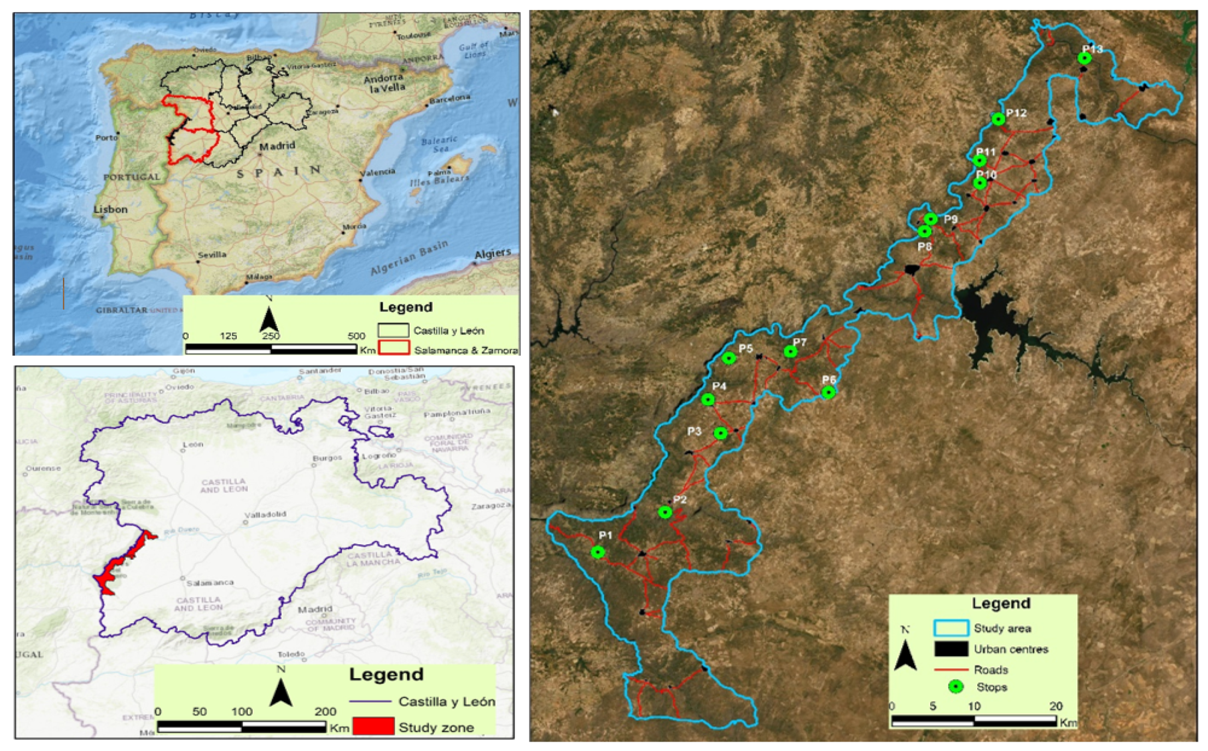
Figure 2.
Geologic map. Source: Author’s elaboration.

Figure 3.
Geomorphological map. Source: Author’s elaboration.

Figure 4.
Edaphological map. Source: Author’s elaboration.

Figure 5.
Itinerary of study. Source: Author’s elaboration.
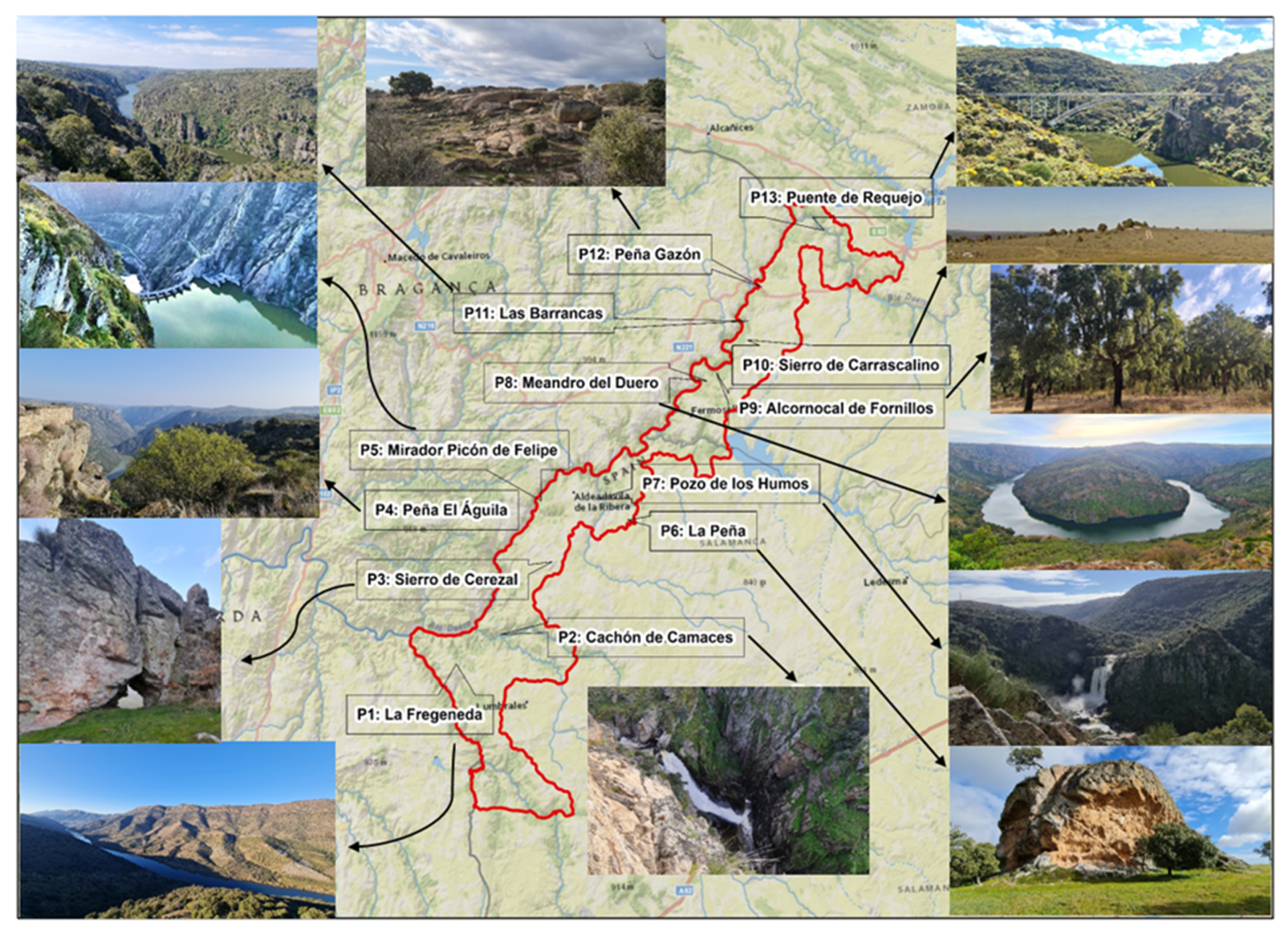
Figure 6.
(A) Chromic alisole. (B) Chromic luvisole. (C) Chromic cambisole. (D) Dystric gleysole. (E) Eutrophic regosole. (F) Litic leptosole. Source: Author’s elaboration.
Figure 6.
(A) Chromic alisole. (B) Chromic luvisole. (C) Chromic cambisole. (D) Dystric gleysole. (E) Eutrophic regosole. (F) Litic leptosole. Source: Author’s elaboration.

Figure 7.
(A-1) View from Mirador Mafeito; (A-2) Quartz hydrothermal seams in road cuts. (B-1) Cachón del Camaces; (B-2) View from Huebra river valley. (C) Sierro Cerezal de Peñahorcada; (D) View of the Duero from the Peña Águila viewpoint. (E) View of Aldeádavila Dam. (F) View Inselberg de la Peña. Source: Author’s elaboration.

Figure 8.
(A) Pozo de los Humos. (B) Meander of the Duero. (C) Alcornocal de Fornillos. (D) View of the Duero from the Mirador de Las Barrancas. (E) Sierro de Carrascalino. (F) block chaos Peña Gazón. (G) Requejo Bridge. Source: Author’s elaboration.
Figure 8.
(A) Pozo de los Humos. (B) Meander of the Duero. (C) Alcornocal de Fornillos. (D) View of the Duero from the Mirador de Las Barrancas. (E) Sierro de Carrascalino. (F) block chaos Peña Gazón. (G) Requejo Bridge. Source: Author’s elaboration.


Table 1.
Parameter and Valoration.
| Value Class | Parameter | Description | Valoration | ||||
|---|---|---|---|---|---|---|---|
| Parameter Characterisation Aspects | P. | VC | VD | VT | |||
| INTRINSEC | Representative (R) | It reports on the quality of the place to illustrate the adequately illustrate the characteristics of the domain | Unhelpful as a model to represent, even partially, a feature or process | 0 | X30 | X5 | X0 |
| Useful as a model to partially represent a feature or process | 1 | X30 | X5 | X0 | |||
| Useful as a model to represent, in its entirety, a feature or process. | 2 | X30 | X5 | X0 | |||
| Best known example, at the geological domain level, to represent a feature/process | 4 | X30 | X5 | X0 | |||
| Type locality character (T) | Informs about the quality of the site as a reference stratigraphic, palaeontological, mineralogical etc. | It does not comply, by default, with the following three premises | 0 | X10 | X5 | X0 | |
| Regional reference locality | 1 | X10 | X5 | X0 | |||
| Internationally used reference locality (metallogenic, petrological, mineralogical, tech-tonic, stratigraphic, etc.), or fossil type locality, or biozones for scientific use. | 2 | X10 | X5 | X0 | |||
| IUGS-accepted stratotype or IMA type locality | 4 | X10 | X5 | X0 | |||
| Degree of scientific knowledge of the site (K) | Indicates that its geological relevance and scientific interest make it the subject of publications and scientific studies. | There are no published works or doctoral theses on the site. | 0 | X15 | X0 | X0 | |
| There are published works and/or doctoral theses on the site. | 1 | X15 | X0 | X0 | |||
| Researched by several scientific teams and the subject of doctoral theses and published works referenced in national scientific journals. | 2 | X15 | X0 | X0 | |||
| Researched by several scientific teams and subject of doctoral theses and published works referenced in international scientific journals. | 4 | X15 | X0 | X0 | |||
| Conservation status (C) | Reports the existence of physical deterioration of the trait | Heavily degraded/degraded: the site is practically destroyed or very deteriorated. | 0 | X10 | X5 | X0 | |
| Altered: with deterioration that prevents the appreciation of some features of interest. | 1 | X10 | X5 | X0 | |||
| Favourable with alterations: some deterioration that does not significantly affect the value or interest of the LIG | 2 | X10 | X5 | X0 | |||
| Favourable: the LIG in question is well preserved, practically intact | 4 | X10 | X5 | X0 | |||
| Observation conditions (O) | Indicates the extent to which the environment makes it easier or less easy to observe the feature environment to observe the feature | With elements strongly masking the features of interest | 0 | X10 | X5 | X5 | |
| With elements masking the LIG and preventing the appreciation of some features of interest | 1 | X10 | X5 | X5 | |||
| With some elements that do not prevent the LIG from being observed in its entirety | 2 | X10 | X5 | X5 | |||
| Perfectly observable practically in its entirety with ease | 4 | X10 | X5 | X5 | |||
| Rarity (A) | Reports on the scarcity of features similar to the one described | There are quite a few similar sites in the region | 0 | X15 | X5 | X0 | |
| One of the few known examples at regional level | 1 | X15 | X5 | X0 | |||
| Only known example at regional level | 2 | X15 | X5 | X0 | |||
| Only known example at national (or international) level | 4 | X15 | X5 | X0 | |||
| Diversity (D) | Reports the existence of several types of geological interest on the same site | The LIG only presents the main interest rate. | 0 | X10 | X10 | X0 | |
| The LIG has another interest rate, in addition to the principal, not relevant | 1 | X10 | X10 | X0 | |||
| LIG has 2 interest rates in addition to the principal, or only one but relevant one | 2 | X10 | X10 | X0 | |||
| The LIG has 3 or more interest rates in addition to the principal, or only two other but relevant ones | 4 | X10 | X10 | X0 | |||
| Spectacularity or beauty (B) | Reports the visual quality of the feature | Does not meet, by default, all three of the following three conditions | 0 | X0 | X5 | X20 | |
| 1) high relief extent, or 2) large watercourses/large sheets of water (or ice), or 3) remarkable chromatic variety. Also fossils and/or colourful minerals | 1 | X0 | X5 | X20 | |||
| There are 2-3 of the first characteristics. Also spectacular fossils or minerals | 2 | X0 | X5 | X20 | |||
| Coincidence of the first three characteristics | 4 | X0 | X5 | X20 | |||
INTRINSIC AND USE | Didactic Content (CDD) | Indicates whether the feature lends itself more or less easily to teaching or is already used for this purpose. | It does not meet, by default, the following three premises | 0 | X0 | X20 | X0 |
| It illustrates university curricular content | 1 | X0 | X20 | X0 | |||
| It illustrates curricular content at any level of the education system. | 2 | X0 | X20 | X0 | |||
| Used regularly in didactic activities at any level of the education system | 4 | X0 | X20 | X0 | |||
| Disclosure Content (CDV) | Indicates whether the feature lends itself more or less easily to disclosure or is easily disclosed or is already used for this purpose. | By default, it does not comply with the following three premises | 0 | X0 | X0 | X15 | |
| It illustrates in a clear and expressive way to groups of a certain cultural level. | 1 | X0 | X0 | X15 | |||
| It illustrates in a clear and expressive way to groups of any cultural level about the importance or usefulness of Geology. | 2 | X0 | X0 | X15 | |||
| It is being habitually used for dissemination activities. | 4 | X0 | X0 | X15 | |||
| Potential for tourism and recreational activities (PTR) | Linked to the potential for use. It informs whether the site meets the conditions for leisure activities or whether leisure activities are already taking place. | No tourism or recreation possibilities | 0 | X0 | X0 | X5 | |
| Tourist possibilities or recreational activities possible | 1 | X0 | X0 | X5 | |||
| Tourist possibilities and recreational activities possible | 2 | X0 | X0 | X5 | |||
| Organised activities are available | 4 | X0 | X0 | X5 | |||
USE | Logistics infrastructure (IL) | Informs about the existence of accommodation and restaurants | It does not comply, by default, with the following three premises | 0 | X0 | X15 | X5 |
| Accommodation and restaurant for groups up to 20 persons within 25 km | 1 | X0 | X15 | X5 | |||
| Accommodation and restaurant for groups of up to 40 persons within 25 km | 2 | X0 | X15 | X5 | |||
| Accommodation and restaurant for groups of 40 people less than 5 km away | 4 | X0 | X15 | X5 | |||
| Socio-economic environment (ES) | Reports the existence of several types of geological interest on the same site | The LIG only presents the main interest rate. | 0 | X10 | X10 | X0 | |
| The LIG has another interest rate, in addition to the principal, not relevant | 1 | X10 | X10 | X0 | |||
| LIG has 2 interest rates in addition to the principal, or only oneThe LIG has another interest rate, in addition to the principal, not relevant but relevant one | 2 | X10 | X10 | X0 | |||
| The LIG has 3 or more interest rates in addition to the principal, or only two other but relevant ones | 4 | X10 | X10 | X0 | |||
| Association with other elements natural, historical or ethnological heritage (NH) | Whether the site has other non-geological features of interest, which may attract more visitors | No natural or cultural heritage elements within a radius of 5 km | 0 | X0 | X5 | X5 | |
| Presence of a single natural or cultural heritage element within a radius of 5 km | 1 | X0 | X5 | X5 | |||
| Presence of several natural or cultural heritage elements within a radius of 5 km | 2 | X0 | X5 | X5 | |||
| Presence of several elements of both natural and cultural heritage within a radius of 5 km | 4 | X0 | X5 | X5 | |||
| OF USE AND PROTECTION | Population density (PD) | Linked to potential visits and the increased likelihood of vandalism | Less than 200,000 inhabitants within a radius of 50 km | 1 | X0 | X5 | X5 |
| Between 200,000 and 1,000,000 inhabitants within a radius of 50 km | 2 | X0 | X5 | X5 | |||
| More than 1,000,000 inhabitants within a radius of 50 km | 4 | X0 | X5 | X5 | |||
| Accessibility (AC) | It means easier access for visitors, but also easier access for vandalism. | Does not meet, by default, the following three conditions (tarmac road with no parking facilities, footpath or road, TT track, boat, etc.) | 0 | X0 | X10 | X10 | |
| Direct access by unpaved track but passable for passenger cars | 1 | X0 | X10 | X10 | |||
| Direct access by asphalted road with parking for passenger cars | 2 | X0 | X10 | X10 | |||
| Direct access by asphalted road with parking for coaches | 4 | X0 | X10 | X10 | |||
| LIG extension (E) | Related to the non-fragility of the element relative to its extent | Metric features (vulnerable to visitation) | 0 | X0 | X5 | X15 | |
| Hectometric features (not vulnerable to visitation but sensitive to aggressive anthropogenic activity) | 1 | X0 | X5 | X15 | |||
| Hectometric features (may suffer some deterioration from human activities) | 2 | X0 | X5 | X15 | |||
| Kilometric features (difficult to deteriorate by human activities) | 4 | X0 | X5 | X15 | |||
| Proximity to recreational areas (ZR) | Related to proximity to tourist or recreational areas Linked to potential number of visitors and increased possibility of vandalism | Location more than 5 km from recreational areas (campsites, beaches, etc.) | 0 | X0 | X0 | X5 | |
| Site within 5 km and more than 2 km of recreation areas | 1 | X0 | X0 | X5 | |||
| Site within 2 km and more than 500 m from a recreation area | 2 | X0 | X0 | X5 | |||
| Site located within 500 m of a recreation area | 4 | X0 | X0 | X5 | |||
Table 2.
Data obtained from the evaluations of each parameter by stops and results of the scientific, educational and cultural interest of each geosite.
Table 2.
Data obtained from the evaluations of each parameter by stops and results of the scientific, educational and cultural interest of each geosite.
| Parameter | P1 | P2 | P3 | P4 | P5 | P6 | P7 | P8 | P9 | P10 | P11 | P12 | P13 |
|---|---|---|---|---|---|---|---|---|---|---|---|---|---|
| Representativeness | 4 | 2 | 2 | 2 | 2 | 2 | 2 | 4 | 4 | 2 | 2 | 2 | 2 |
| Type locality character | 2 | 1 | 1 | 1 | 1 | 1 | 1 | 1 | 1 | 1 | 1 | 1 | 1 |
| Degree of scientific knowledge of the site | 4 | 1 | 1 | 0 | 4 | 4 | 4 | 0 | 1 | 1 | 2 | 2 | 0 |
| Conservation status | 2 | 4 | 2 | 2 | 4 | 4 | 4 | 2 | 4 | 4 | 4 | 4 | 4 |
| Conditions of observation | 4 | 4 | 4 | 4 | 4 | 4 | 4 | 4 | 4 | 4 | 4 | 4 | 4 |
| Rarity | 2 | 1 | 1 | 1 | 1 | 1 | 1 | 2 | 2 | 1 | 1 | 1 | 1 |
| Diversity | 2 | 2 | 1 | 1 | 2 | 2 | 2 | 1 | 1 | 1 | 2 | 2 | 2 |
| Spectacularity or beauty | 4 | 2 | 1 | 1 | 4 | 2 | 2 | 1 | 2 | 1 | 2 | 1 | 1 |
| Didactic content | 2 | 2 | 2 | 2 | 4 | 2 | 2 | 4 | 2 | 2 | 2 | 2 | 2 |
| Informative content | 1 | 2 | 2 | 2 | 2 | 2 | 2 | 2 | 2 | 2 | 2 | 2 | 1 |
| Potential for tourism and recreational activities | 4 | 2 | 1 | 2 | 2 | 2 | 2 | 2 | 1 | 2 | 2 | 2 | 2 |
| Logistical infrastructure | 2 | 2 | 1 | 2 | 2 | 2 | 4 | 2 | 2 | 2 | 2 | 2 | 2 |
| Socio-economic environment | 2 | 2 | 4 | 1 | 1 | 1 | 1 | 1 | 2 | 2 | 4 | 2 | 2 |
| Association with other heritage elements | 2 | 0 | 2 | 2 | 4 | 2 | 2 | 1 | 0 | 1 | 1 | 1 | 1 |
| Population density | 1 | 1 | 1 | 1 | 1 | 1 | 1 | 1 | 1 | 1 | 1 | 1 | 1 |
| Accessibility | 1 | 4 | 2 | 2 | 2 | 1 | 1 | 2 | 2 | 4 | 2 | 4 | 4 |
| Extent of the LIG | 1 | 4 | 4 | 4 | 4 | 1 | 2 | 4 | 4 | 4 | 4 | 4 | 4 |
| Proximity to recreational areas | 4 | 2 | 2 | 4 | 2 | 4 | 0 | 1 | 1 | 0 | 2 | 2 | 2 |
| Total | 44 | 38 | 34 | 34 | 46 | 38 | 37 | 35 | 36 | 35 | 40 | 39 | 36 |
Table 3.
Assessment of Scientific, Educational and Tourist Interest.
| Assessment of Scientific, Didactic and Touristic Interest | |||||||||||||
|---|---|---|---|---|---|---|---|---|---|---|---|---|---|
| P1 | P2 | P3 | P4 | P5 | P6 | P7 | P8 | P9 | P10 | P11 | P12 | P13 | |
| Scientific Interest | 310 | 220 | 190 | 165 | 255 | 255 | 255 | 240 | 285 | 210 | 255 | 235 | 205 |
| Educational Interest | 230 | 245 | 215 | 215 | 285 | 200 | 235 | 250 | 230 | 235 | 250 | 245 | 245 |
| Tourist Interest | 205 | 225 | 185 | 235 | 265 | 170 | 175 | 185 | 195 | 200 | 210 | 210 | 195 |
Publisher’s Note: MDPI stays neutral with regard to jurisdictional claims in published maps and institutional affiliations. |
© 2022 by the authors. Licensee MDPI, Basel, Switzerland. This article is an open access article distributed under the terms and conditions of the Creative Commons Attribution (CC BY) license (https://creativecommons.org/licenses/by/4.0/).
Share and Cite
MDPI and ACS Style
Merchán, L.; Martínez-Graña, A.M.; Egido, J.A.; Criado, M. Geomorphoedaphic Itinerary of Arribes Del Duero (Spain). Sustainability 2022, 14, 7066. https://doi.org/10.3390/su14127066
AMA Style
Merchán L, Martínez-Graña AM, Egido JA, Criado M. Geomorphoedaphic Itinerary of Arribes Del Duero (Spain). Sustainability. 2022; 14(12):7066. https://doi.org/10.3390/su14127066
Chicago/Turabian StyleMerchán, Leticia, Antonio Miguel Martínez-Graña, Jose Antonio Egido, and Marco Criado. 2022. "Geomorphoedaphic Itinerary of Arribes Del Duero (Spain)" Sustainability 14, no. 12: 7066. https://doi.org/10.3390/su14127066
Note that from the first issue of 2016, this journal uses article numbers instead of page numbers. See further details here.