Article

The Combined Use of 137Cs Measurements and Zr-Methods for Estimating Soil Erosion and Weathering in Karst Areas of Southwestern China

1
School of Geomatics and Urban Spatial Informatics, Beijing University of Civil Engineering and Architecture, Beijing 102616, China
2
State Key Laboratory of Simulation and Regulation of Water Cycle in River Basin, China Institute of Water Resources and Hydropower Research, Beijing 100038, China
3
School of Energy and Environmental Engineering, University of Science & Technology Beijing, Beijing 100083, China
4
Guizhou Provincial Key Laboratory of Geographic State Monitoring of Watershed, Guizhou Education University, Guiyang 550018, China
*
Author to whom correspondence should be addressed.
Sustainability 2022, 14(8), 4810; https://doi.org/10.3390/su14084810
Submission received: 22 February 2022 / Revised: 6 April 2022 / Accepted: 8 April 2022 / Published: 17 April 2022

Abstract

:
Soil physical erosion and chemical weathering quantification at the slope scale are important to reveal the material cycle of the ecosystem in the karst region, because of the high heterogeneity due to the complex habitats. The Zr-based mass balance method has been widely used to quantify long-term physical erosion and chemical weathering at the slope scale, but the method is still in the exploratory research stage for quantifying short-term physical erosion and chemical weathering. In this paper, sloping fields (nine sampling sites and two sloping fields) in Zunyi, within the Guizhou karst region, were studied. We attempted to quantify the short-term physical erosion and chemical weathering rates by 137Cs combined with the Zr-based mass balance method, and an ideal distribution curve of the Zr concentration in the soil surface layer of a karst region is proposed. The results showed the following: (1) The average soil erosion rate on the slope of the study area is 580 t/(km2·a), which is equivalent to 14% of the average value of the Wujiang River basin in which it is located. This shows that the spatial distribution of soil erosion in this area varies significantly. (2) The Zr concentration in the erosion profile (EUC (1)) corresponds to 48% of that in the deposition profile (DUC (3)). This indicates that physical erosion in the study area survives chemical weathering, which is also consistent with the relationship model hypothesis. In addition, the vertical distribution characteristics of Zr concentration in all profiles are basically consistent with the ideal hypothesis curve. (3) The chemical weathering rate of the topsoil has been preliminarily estimated to be around 30 t/(km2·a), and the ratio between the physical soil erosion and chemical weathering is 20:1. The results show that the physical erosion is dominant over the chemical weathering of topsoil, and the chemical weathering rate was proportional to the physical erosion. This study provides a new method for quantifying short-term soil erosion and weathering erosion at the slope scale in karst regions, which is important for regional ecological restoration and sustainable development.

1. Introduction

The chemical weathering of crustal surface rock minerals provides solutes and nutrients to surface soils and plays an important role in the Earth’s critical zone material cycle [1]. However, the chemical weathering in global ecosystem cycles requires a better quantitative understanding of the interconnection between chemical weathering and physical erosion. Because the interaction of chemical weathering and physical erosion generates soil and shapes the Earth’s surface, quantifying them both is very important for the quantitative research of soil development and ecosystem cycles [1,2,3].
The world’s largest carbon pool is carbonate (99.58% of the total global supply), which is the bedrock of karst areas. Organic acids and chelates produced in the soil intensify the chemical weathering of carbonate rocks and change the soil’s organic carbon. The chemical weathering and physical erosion of these areas not only directly affect regional ecological protection and sustainable development, but also play an important role in the global carbon cycle [4]. In terms of studies on the physical erosion of slopes, the 137Cs tracer method has been used widely in recent years [5]. Several studies have focused on the 137Cs distribution characteristics and related soil erosion rates of different land-use types [6,7,8,9]. We developed geochemical-dynamics-based moving-boundary models for the special rainfall and soil erosion characteristics of the karst region in southwest China and carried out preliminary application and verification in Zunyi [10]. In addition, we have used this method to conduct quantitative studies of soil erosion and chemical weathering in other areas of the karst slope in southwest China [11,12]. The chemical erosion rate is currently estimated based on the corrosion rate of carbonate rocks according to the statistics of a single profile or multiple profiles [13]. This method is easy to implement, but there are certain limitations. The rate of chemical erosion of the soil in this area is determined by the corrosion rate of the standard specimen of buried limestone at different depths in the soil layer. The degree of weathering of the soil layer is higher than that of the corrosion specimen, and thus the calculation result will be larger than the actual value [14,15].
Zr is mainly present as the stable zircon (ZrSiO4) in the supergene process, and the geochemical properties are stable during the formation of the weathering crust profile. The Zr content in the parent material horizon (the soil layer C or the bedrock) is used for reference to calculate the long-term weathering rate of the profile, which has been widely promoted in many parts of the world [16,17,18,19,20,21,22]. Riebe et al. developed a mass balance model based on the Zr loss method principle and used the integrated and analytical approaches to treat the entire weathered profile as a weathered layer, calculating the chemical erosion rate with the long-term physical erosion of the profile [1,23,24,25].
The karst area in Guizhou, China is the largest continuous karst region in the world. Among the top three karst zones, it has the largest area of continuous bare carbonate rocks and is the most ecologically fragile region [25]. Determining the current weathering and erosion processes in this area and the material migration path and rate provides information that is important for regional ecological restoration and sustainable development [26]. According to our previous related studies, soil properties, topographic features, and vegetation cover characteristics jointly influence physical erosion and chemical weathering on karst slopes, and chemical weathering is strongest under moderate physical erosion [11]. The Zr-based mass balance method can be applied to quantify long-term physical erosion and chemical weathering at the slope scale, but there is a research gap in the applicability of this method to quantify short-term physical erosion and chemical weathering. Zr is often enriched in the topsoil, and the concentration of layer B does not change much. Previously, according to studies on the profiles in the Xinpu area of Zunyi, Guizhou, we found that Zr is generally enriched at depths of 0 to 25 cm, and the concentration of Zr decreases rapidly below the enrichment depth, with little change over different areas [27,28,29]. If the Zr in the topsoil in the study area can also meet the preconditions of the mass balance model, then the weathered-profile Zr is enriched in the surface layer of the soil, and the relative thickness is h1, where h1 satisfies the condition of mass conservation: the relative thickness of h1 is constant under the effect of physical erosion and weathering erosion. The physical erosion can be calculated according to 137Cs to obtain the current chemical erosion rate of the profile.
Based on the above assumptions, this paper attempts to quantify the short-term physical erosion and chemical weathering rates through the method of 137Cs combined with Zr elements in Zunyi City, southwest China. The specific research objectives of the present study are as follows: (1) use 137Cs to investigate the spatial distribution characteristics of physical erosion on the hillslope soil; (2) create a relationship model between the physical erosion and chemical weathering rate of the soil surface layer on sloping land based on the conservation principle of Zr element mass; and (3) use the relation model to calculate and combine the physical erosion rate and obtain the weathering rate.

2. Materials and Methods
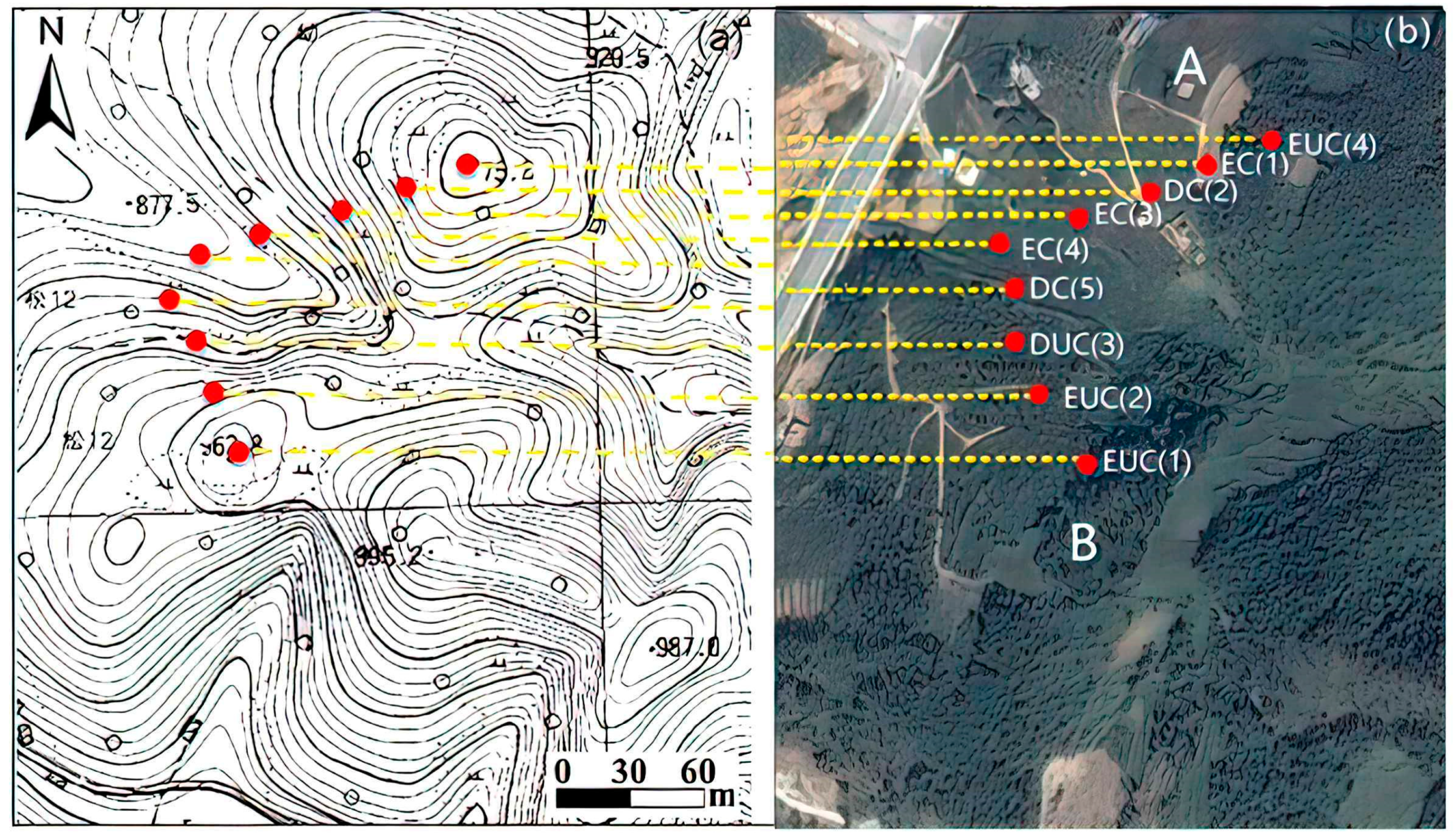
2.1. Study Area

The study area is located in the Zunyi region of Guizhou Province, China (Figure 1a), in the northeastern part of the Yunnan–Guizhou Plateau, with complex geomorphological types, great topographic relief, and altitudes generally ranging from 1000 to 1500 m. The geomorphic types are complex, with a very rugged topography. The altitude is typically 1000–1500 m. The area of Pingba and valley basins accounts for 6.75%, the mountainous regions cover 65.08% (elevation over 500 m), and the hills cover 28.35% (elevation between 200–500 m) of the area. The geomorphic types of the city are divided into three types: erosion landforms, karst landforms, and karst-structure landforms, where the karst and karst-structure geomorphology are the primary landforms covering more than 2/3 of the entire city area.
The sampling site was located in the town of Xinpu within the city of Zunyi, where the bedrock consists of dolomites from the upper Cambrian Loushanguan group, with a total thickness of 1000–1300 m (Figure 1b). Sampling sites in the middle region of the continuous carbonate areas were chosen to reduce the influence on weathering and erosion of other types of rock-weathering products. A previous study showed that the content of SOC (soil organic carbon) in the surface soil of the study area was about 11 g/kg, and the content decreased with the depth of the profile. After profile classification, the soil particles were basically concentrated in the silt (5–50 μm) and accounted for about 60%, and the clay content was the lowest, accounting for about 15% of the total mass.
It is critical to determine whether the sampling sites are representative when studying soil erosion on a slope, due to the relatively limited investigation of spatial dimensions. Here, the following two factors must be considered when choosing sampling sites: (1) a representative hillslope should be chosen according to the geomorphic features in the study area; (2) sampling is performed at the top, shoulder, piedmont, foot, and valley for mountains with different altitudes (all on the same slope). Samples were collected from a small catchment in Shuanglong Village in Western Xinpu (Figure 2). The catchment is a typical karst erosion landform, with an area of about 0.52 ha, including two slopes, A and B. The terrain of the slope is undulating, the slope of the mountaintop and the mountainside is steep, and the slope at the foot of the mountain is gentle. Its altitude ranges from 850 to 960 m, and its slopes are steep, with an average angle of 40.58°. In the middle of the two slopes, there is a valley and flat land. The sampling points were located on two adjacent slopes, A and B, where the land-use type of slope A was orchard and the land-use type of slope B was woodland, and the trees were about 70 years old (the bottom of the slope was rice paddies). Four of these sites (EUC(1), EUC(2), DUC(3), and EUC (4)) were uncultivated profiles, and the other five sites (EC(1), DC(2), EC(3), EC(4), and DC(5)) were cultivated profiles. In order to accurately identify the existence of underground soil leak phenomena on the slope, all sampling sites were stratified. The stratified samples were stripped layer by layer with a blade in the area of 10 × 10 cm2 at intervals of 2 cm and to a depth of about 30 cm. A total of 135 samples in 9 profiles were collected.

2.2. Field Soil Sampling and Laboratory Analysis

The samples were weighed indoors after drying and then ground to the size of 0.15 mm for analysis. With good stability, the United States CanBerra company’s S-100 series 16,384 multichannel analyzer was used for the analysis of 137Cs specific activity, and SAMPO-90 software for data processing. The activity of 137Cs was detected by 662 keV peak when the counting time was more than 50,000 s. At the 95% confidence level, the accuracy of analysis was kept at ±5%.
Five reference points were situated at the low mountain top, about 1000 m south of the slope in the study area. The terrain around the top of the mountain is flat, and the seminatural forest is hardly disturbed by human activities. The natural secondary forest has a large preservation area and a forest coverage rate of more than 70%. According to the preliminary calculation of trunk radius, the age of the trees was about 50 years, which conforms to reference value sampling. The average inventory of 137Cs in these samples was 960 Bq/m2. The variability of reference samples was similar to that measured in other studies [30,31,32].
To analyze the change in concentration of Zr in profiles, sites not subject to human disturbance served as sampling sites. Three profile samples were collected from EUC(1), EUC(2), and DUC(3). According to the DZ/T0223-2001 standard, we used HR-ICP-MS to analyze the Zr content in the samples, and the humidity and temperature of the experimental environment were 30% and 20°.

2.3. Physical Erosion Rate

The 137Cs soil erosion models for undisturbed land mainly include empirical models, profile models, and the diffusion models, among which the diffusion model design is more comprehensive [33,34,35,36]. The widely used diffusion model is the simplified transport model, which is based on the transport model by neglecting the convective term in the diffusion equation and improving the practicality of the model:
A r m ( T ) = A r e f ( T ) i = 1 T e r f c [ H 2 D i ]
where A r m ( T ) is the remaining 137Cs inventory (mBq cm−1), A r e f ( T ) is the reference value of 137Cs (mBq cm−1), T is the erosion initiation time, H is the average thickness of soil erosion (cm), D is the diffusion coefficient (cm−2 a−1), and e r f c is the error function.
The simplified transport model is adapted to soil erosion estimation in arid areas, but when using the model in areas with a long rainy season duration, the value of A r m ( T ) in Equation (1) will be larger than the actual value, which affects the estimation accuracy. To solve these problems, we developed the new moving-boundary model [10], as in Equation (2). This model improves the basic simplified transport model and mainly applies to uniform rainfall areas that have long-term soil erosion. This model is based on the geochemical dynamics moving-boundary principle, which has been successfully applied to soil erosion evaluation in the karst region of Guizhou, as in Equation (2):
A r m ( T ) = A r e f ( T ) ( e r f [ u t 2 D ] 2 e 3 u 2 t 4 D ( e r f [ u t D ] 1 ) 1 )
where t is the erosion initiation time and u is the erosion rate (cm a−1).

2.4. Chemical Erosion Rate of the Profile

The Zr element loss method requires the same soil parent material at the sampling point. The Zr content in the profile is distributed in a constant proportion, and the lower part of the profile (less weathering and lower Zr content) is used as the reference (parent material) to calculate the rate of weathering erosion of the upper part of the profile (Zr content is relatively high) [37].
L o s s G a i n ( X ) = S a m p l e x × ( P a r e n t z r S a m p l e z r ) P a r e n t x
where S a m p l e x and S a m p l e z r represent the contents of elements X and Zr in the upper weathered soil, and P a r e n t x and P a r e n t z r represent the amount of X and Zr in the lower reference parent layer, respectively. Whitfield et al. adopted the Zr loss method in the acid soil region of Alberta, Canada, and considered the soil layer C to be the parent layer and the rooting area as the weathered layer (soil layer A and soil layer B) [38]. They calculated the average chemical erosion rate of the rooting area (premise: the soil age was known). The Zr element loss method can flexibly select the weathered layer and the parent material horizon to calculate the chemical erosion rate of the weathered layer according to the enrichment characteristics of the profile Zr. However, in practical applications, the age of the weathered layer is often difficult to define, especially in eroding landscapes, and therefore the application of this method is also limited [1,28].
Regarding the definition of soil age, Riebe et al. developed a mass balance model based on the principle of Zr loss [1]. They regarded all the soil layers (soil layer A, B, and C) as weathered layers, and the bedrock as the parent layer; they further assumed that the weathered layer maintains a state of mass conservation through the integrated approach and analytical approach.
R = D + E + W
where R is the rate of conversion of bedrock to weathered material, D is the rate of total denudation, E is the rate of physical erosion, and W is the rate of chemical weathering. For an element x vulnerable to the weathering effect, Equation (1) can be converted to the following equation:
D · [ X ] r o c k = E · [ X ] s o i l + W x
where [ X ] r o c k represents the concentration of element x in rock and [ X ] s o i l is the concentration of element x in soil. The following equation can be used for immobile chemical elements, e.g., the migration of element Zr is only influenced by physical erosion:
D · [ Z r ] r o c k = E · [ Z r ] s o i l
where [ Z r ] r o c k represents the Zr concentration in the rock and [ Z r ] s o i l is the Zr concentration in the soil. Substituting Equation (6) into Equation (5) yields the following:
W = E ( [ Z r ] s o i l [ Z r ] r o c k 1 )
The mass conservation method can calculate the chemical erosion rate W by using physical erosion E without considering the age of the soil. However, the method takes the bedrock as the parent material horizon, and it can only be used to calculate the long-term chemical erosion rate.
Based on the research ideas described in these two methods, we assumed that the weathered-profile Zr is enriched on the surface layer of the soil, and the relative thickness is h1; the thickness of the interface below the surface until the geotechnical interface is h2, and the Zr concentration of h2 is less than that of h1. The overall concentration does not change markedly: The profile can be divided into a weathered layer h1 and a parent material horizon h2, according to the Zr loss method. In addition, h1 satisfies the condition of mass conservation: the relative thickness of h1 is constant under the mass balance state. The weathering rate W can be calculated via the physical erosion rate E based on Equation (7), because the thickness of h1 is low, and the turnover time is shorter. We explored the possibility of using this method to calculate the weathering rate in the karst area.
The karst area in China is characterized by strong karstification, a high degree of weathering on the profile, low acid insoluble contents (less than 5%), and the leaching of a large amount of salt-based ions such as Ca++, Mg++, K+, and Na+ in the weathered crust. Thus, Zr is often enriched on the top or upper part of the karst weathered crust and is used as the weathering rate of the reference element profile [39]. The basement rock of Xinpu Town is the dolomite of the Loushanguan group on the upper part of the Cambrian system, with a total thickness of 1000~1300 m; this ensures the single source and uniformity of the weathered products at the sampling point. Our preliminary studies showed that the soil in the upper layer of the profile had a high CIA value that continuously increased from the protolith to the upper soil layer, indicating that the leaching effect was strong and the degree of weathering was high—thus, the contents of Zr, Ti, and other inactive elements in the entire soil layer elements did not change markedly. The enrichment only occurred in the surface layer of the soil [40].
The enrichment of Zr in the surface of the soil profile is mainly due to changes in soil density, while the organic carbon of topsoil has a high correlation with density [41]. We studied and analyzed the distribution characteristics of SOC over the two profiles of the study area (Figure 3). The SOC of the two profiles increased sharply from 0 to 25 cm. The SOC content was drastically reduced using 25 cm as the boundary. From a depth of 25 cm to the bedrock, the change in SOC content was shown as an inverted L-type according to the depth of the profile. This meant that the SOC content decreased slowly as the depth of the profile deepened [42].
We analyzed the distribution of 13C in the study area (Figure 4). The effect of 13C can reflect the replacement and migration of the profile SOC. The 13C was enriched at the top of the profile and decreased along with the profile. This was because the surface soil organic material mainly came from the dead branches and leaves of the surface vegetation. The carbohydrate and amino acids enriched in 13C are preferentially degraded in the early stage of the decomposition of soil organic material due to the fractionation produced by plant metabolism. The lipids and lignin are depleted in 13C and may be preferentially accumulated, leading to increased content along with the depth of the soil layer. The 13C value of the soil organic material decreased with increasing profile depth. In addition, the karst area had strong eluviation and deposition, and the organic material that was rich in 13C in the lower part may have migrated upward due to capillary action. The profile 13C had little fractional distillation with the depression of the profile, indicating that the organic material of the topsoil did not easily migrate downward. This may be because the limestone is a product of carbonate rock subjected to corrosion and weathering. The limestone is restricted by the characteristics of the parent rock during soil formation with a low degree of mineral weathering. The content of Ca+, Mg+, and other elements in the soil was rich. The organic material was continuously decomposed to form humus and combined with Ca and Mg and other plasmas to form highly condensed and stable humus calcium that greatly reduced the degree of decomposition in organic material.
Lime soil has a higher clay content than yellow soil, and the higher clay content has a protective effect on the production of soil organic material and reduces the degree of decomposition. The low decomposition usually results in a smaller isotope fractionation, and this may be the main reason for the smaller variation in the 13C value of the limestone profile [42]. At the same time, the half-life of the organic carbon plexus of the topsoil in nonagricultural lands in karst area is about 722 d, which indicates that the turnover time of organic carbon in the topsoil is longer. This suggests that the organic carbon in the topsoil is stable [43].
We produced an ideal concentration distribution map of Zr in the soil surface in this area (Figure 5). Zr is enriched at depths ranging from 0 to 25 cm. It decreases and remains stable at deeper areas. We used 0–25 cm as the weathered layer h1, and the soil layer below 25 cm is the parent material horizon h2.
If the organic material in the surface layer is stable, then the soil density will remain unchanged, and the h1 layer will be in a state of mass balance. Soils h1 and h2 in the study area met the preconditions of the mass conservation model, and we could build the equation as follows:
W = E ( [ Z r ] h 1 [ Z r ] h 2 1 )
The preliminary research results showed that the average physical erosion rate of the slope in the study area was 0.08 cm, and the replacement time of the topsoil in the top 25 cm was about 300 years [14]. The physical erosion rate E calculated by 137Cs could be substitute into Equation (8) to calculate the current chemical erosion rate Ws. Equation (8) assumes the following:
Z = [ Z r ] h 1 [ Z r ] h 2
The average Zr concentrations in the upper layers [ Z r ] h 1 were slightly higher than the lower layers ( [ Z r ] h 2 ), indicating that the value of Z may vary between zero and one in the three profiles.
W s = E · Z ( 0 < Z < 1 )
Equation (10) is a relationship between the chemical weathering rate Ws and the physical erosion E in the topsoil layer. The following conclusions were drawn based on this relationship: (1) the weathering rate Ws is proportional to the physical erosion E; and (2) the physical erosion rate is larger than the chemical weathering rate. This hypothesis is also consistent with our recent similar research—the surface soil weathering rate of the same slope erosion profile is higher than that of the sedimentary profile. Under moderate soil erosion intensity, the surface soil may undergo intense chemical weathering, which may lead to the massive dissolution of silicate minerals in the soil.

3. Results and Discussion

3.1. Evaluation of Physical Erosion

The value of the 137Cs inventory and the erosion rate for the nine samples are shown in Table 1.
The lowest value of the 137Cs inventory of the nine sampling profiles was 150 Bq/m2, and the highest value was 1600 Bq/m2, with a mean value of 875 Bq/m2; the mean value accounted for 92% of the background value (960 Bq/m2), indicating that the soil in this area had a good adsorption of 137Cs, which satisfied the prerequisites for the application of the 137Cs method for erosion estimation [44]. The area ratio activity of 137Cs varied significantly from the top to the foot of the slope on both slopes, and by comparing with the background value, the spatial distribution characteristics of erosion on both slopes were similar, with easy erosion at the top and middle valley sloping parts and deposition at the gently sloping parts of the hillside and foot.
The mean rates of net soil loss and deposition rates were 580 t/(km2·a) and 310 t/(km2·a), respectively. The results showed that the average erosion modulus of Wujiang River Basin in Guizhou Province is 4122 t/(km2·a). The change of erosion intensity was greatly affected by the elevation, slope, and other landforms. Therefore, the spatial distribution of erosion is significantly different. The study area was located in an area of mild erosion, and the erosion modulus was far lower than the average value of the basin. In addition, the soil and water conservation work carried out in the area may also be an important reason for the low rate of soil erosion, as it is reported in the relevant data that the conversion of sloping land to terraced fields has been carried out in the Zunyi area since 1991 [45]. Although the land-use types of the two slopes were different, the general trend of soil erosion distribution from the top to the foot of the mountain was similar, i.e., the hilltops of the two sloping fields were relatively steep at the sampling sites and vulnerable to erosion; the eroded material could easily accumulate in the piedmont and at the bottom of the hills. This indicates that topography might be an important factor that influenced the spatial distribution change of soil erosion in our study area.
Although the average soil erosion rate in the study area was lower than the average value of the basin, the soil erosion condition cannot be ignored, because of the special soil formation mechanism in this area. The main source of soil development in carbonate karst areas is the small amount of insoluble residue in carbonate rocks. The soil production process is very slow, and from the scope of human activities, this extremely low soil production rate indicates that the soil resources in the karst areas have low sustainability under cultivation. Thus, the allowable soil loss should be used to evaluate the effect of erosion in the karst areas. The allowable soil erosion standard in the southwest karst areas is 500 t/(km2·a) [46]. According to this, the average rate in the investigated area exceeded the standard by 16%.

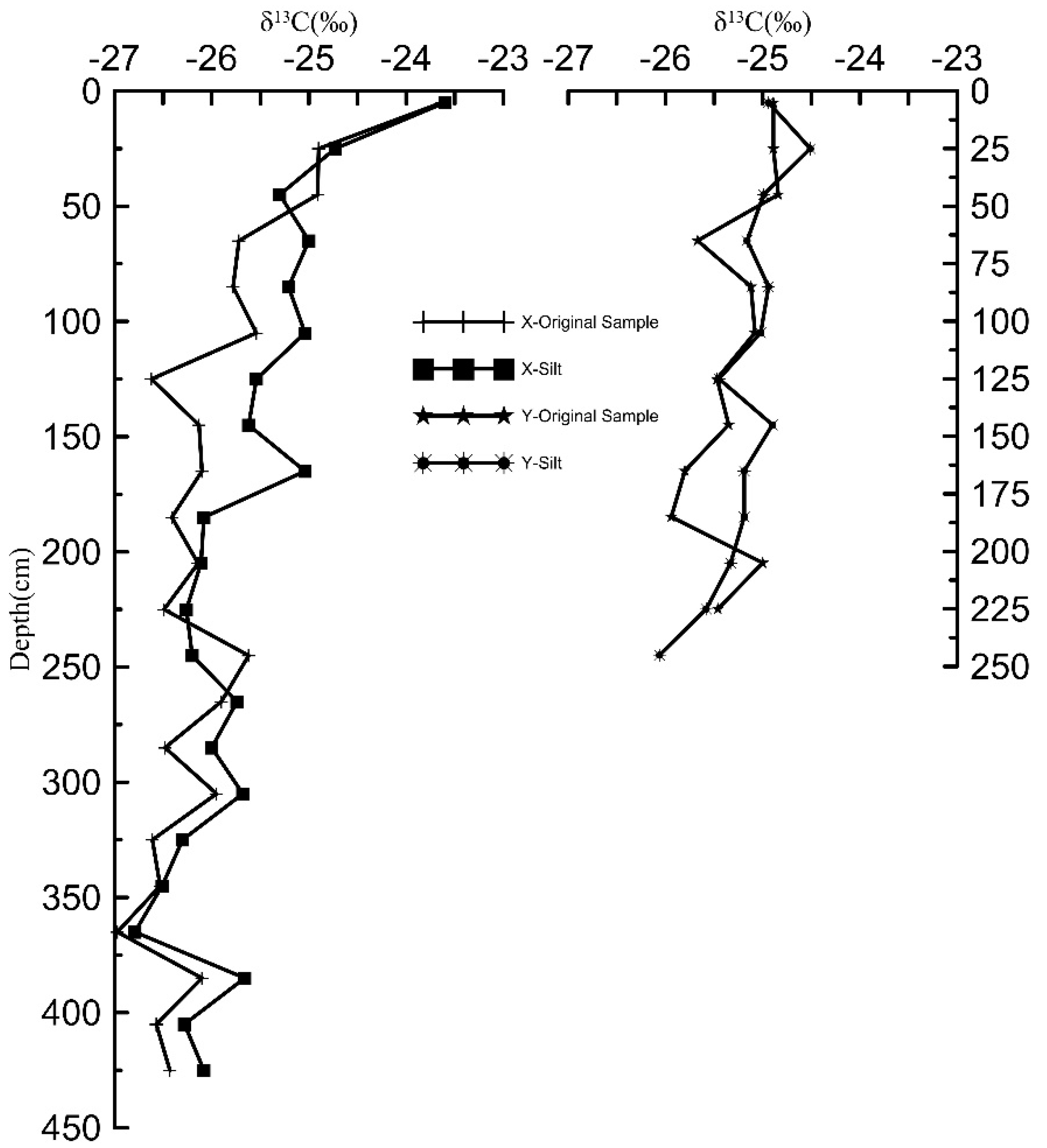
3.2. Distribution Characteristics of Zr

Figure 6 shows the changing curves of Zr concentration for the three profiles of EUC(1), EUC(2), and DUC(3).
The average concentrations for EUC(1), EUC(2), and DUC(3) were 137 mg.kg−1, 247 mg.kg−1, and 282 mg.kg−1, respectively. There was a clear upward trend from the summit to the foot of the hill. Section 3.1 shows that EUC(1) and EUC(2) were erosion profiles, and DUC(3) was a deposition profile. The concentrations of Zr for the three profiles followed the order DUC(3) > EUC(2) > EUC(1), because the sediment was affected by long-term chemical erosion, which varied from the summit to the foot of the hill. A large proportion of Zr in crustal rocks is collected in the form of zircon, which is chemically stable, and it is generally believed that zircon is most soluble only under alkaline conditions, so it remains in the weathering profile during weathering. Zr migrates with surface runoff in two main forms: (1) the mechanical crushing of zircon; (2) adsorption by some clay minerals due to ion exchange adsorption or substitution. EUC (2) and DUC (3) had greater Zr concentrations than EUC (1), indicating the inheritance of eroded material from EUC (2) and DUC (3) to the EUC (1) profiles, reflecting the transport and accumulation of weathering products with surface runoff from the summit to the foot of the mountain under the long-term erosion of karst natural slopes.
Below the dividing line, the Zr concentrations of EUC(1) and EUC(2) rapidly decreased with increasing depth, and the Zr concentration of DUC(3) showed an overall decreasing trend with depth and with apparent variation. The erosion profiles of EUC(1) and EUC(2) both showed in situ weathering, and their upper and lower parts showed apparent chemical differentiation under the influence of chemical leaching. The depositional effect in profile DUC(3) was also visible, and the erosion transport mud (insoluble material) covered the topsoil—the chemical differentiation was weaker than that in EUC(1) and EUC(2). The Zr contents in EUC(2) and DUC(3) decreased significantly after 8 cm. No similar phenomenon was observed in EUC(1). The Zr concentration significantly decreased 8 cm below the topsoil in profiles EUC(2) and DUC(3), perhaps because of a biological effect. This is based on the observation of vegetation coverage at sampling sites EUC(1), EUC(2), and DUC(3). The vegetation coverage at EUC(1) was significantly lower than that at EUC(2) and DUC(3), and various activating elements (for instance, heavy metal elements) could be absorbed and accumulate at the root of vegetables. Thus, the accumulation of activating elements in turn lowered the Zr concentration.

3.3. Evaluation of Chemical Erosion

Equation (8) shows the chemical erosion rates of the three profiles (Table 2).
The minimum value of the chemical weathering rate was 8.3 t/(km2·a), the maximum value was 53.8 t/(km2·a), and the average value was 28.9 t/(km2·a). The ratios of physical erosion to chemical weathering rate were 36:1, 15:1, and 21:1. Additionally, based on E10, the physical erosion and chemical weathering rates of the three profiles were positively correlated. Liu et al. studied the weathering/erosion of the main drainage systems of the Wujiang rivers and concluded that the physical erosion rate in this drainage basin was 13-fold higher than that of the corresponding chemical weathering rate [28]. Jiao et al. reported an average physical erosion of 102 t/(km2·a) and an average chemical erosion rate of 30 t/(km2·a) by using the watershed water chemistry method in the Wujiang region [47]. Comparing the chemical erosion rates obtained from this paper with the above watershed water chemistry method, the results are relatively close and under the same order of magnitude, which illustrates the feasibility of the calculation method in this paper.
The chemical weathering rate of the profile with the largest erosion rate among the three profiles (EUC(1)) was also the largest. The sedimentary profile accumulated more clay minerals (with a thicker soil layer) compared to the erosion profile, but under chemical weathering, the feldspar in the bedrock of the erosion profile dissolved first, followed by the dissolution of clay minerals, resulting in a greater chemical erosion rate in the erosion profile than in the erosion profile [48]. In addition to this, our similar study in the area showed that the loss of HFSEs and REEs in the erosion profile was significantly lower than in the sedimentation profile, mainly due to the preferential weathering of feldspars (dolomite and orthoclase) in the bedrock as a result of high-intensity chemical weathering [11]. The soil profile in the karst region has an obvious leaching effect in the vertical direction, and the weathering degree of the top soil was higher than that of the bottom soil, while the degree of soil weathering was inversely related to the chemical erosion rate. The greater the soil erosion rate, the more the surface soil is lost, and the lower the proportion of soil with a high degree of weathering on the surface of the profile, the higher the chemical erosion rate of the profile.

4. Conclusions

The average inventory of 137Cs in the study area was 875 Bq/m2, which indicates that the soil has good adsorption of 137Cs, which is a prerequisite for soil erosion estimation using 137Cs in this area. The average soil erosion rate of the two karst slopes was 580 t/(km2·a), which was much lower than the average soil erosion rate of the watershed (4122 t/(km2·a)), indicating that the spatial distribution of soil erosion is highly heterogeneous at the karst watershed scale. The soil production process is very slow in the karst area, and although the average soil erosion value is low, it still exceeds the 16% of the allowable soil erosion standard, which shows that the soil and water conservation work still cannot be neglected. The general trend of soil erosion distribution from the top to the foot of the mountain was similar for the two slopes with different land-use categories, indicating that topography might be an important factor that influences the spatial distribution change of soil erosion.
The average content of Zr gradually increased from the top profile to the foot profile, reflecting the transport and accumulation of weathering products with surface runoff from the top to the foot of the karst natural slope under long-term physical erosion. The average chemical erosion rate of the three profiles was 28.9 t/(km2·a), which is close to the results of similar studies in the region and proves the feasibility of the calculation method proposed in this paper. The chemical erosion rate of the erosion profile EUC(1) was larger than that of the deposition profile DUC(3), which proves that soil erosion on the karst slope has a significant contribution to chemical weathering. The ratios of the physical erosion to chemical weathering rate were 36:1, 15:1, and 21:1. Physical erosion dominated over chemical weathering on the topsoil, and the chemical weathering rate was proportional to the physical erosion on the karst hillslope.
In this paper, we constructed a mathematical model of the relationship between soil erosion and weathering by the principle of Zr mass balance in the soil surface layer, and then obtained soil erosion and weathering rates by the 137Cs method, which fills the gap in the research on the relationship between short-term soil erosion and weathering with regard to elemental mass balance in karst areas. However, there were only a few Zr sampling points in the study area, and the next step can be to increase the number of sampling points to study the variation of the Zr concentration in the soil surface layer of the karst area more deeply.

Author Contributions

Methodology, C.Y. and H.J.; writing—original draft preparation, C.Y. and J.L.; writing—review and editing, H.J. and C.S.; software, M.D. All authors have read and agreed to the published version of the manuscript.

Funding

This research was funded by the Scientific Research Project of Beijing Municipal Education Commission (No. KM202110016003), the National Key Research and Development Program of China (No. 2019YFD1100205), the National Natural Science Foundation of China(NSFC) grants(No. 41473122), the Fundamental Research Funds for Beijing University of Civil Engineering and Architecture (No. X20046).

Institutional Review Board Statement

Not applicable.

Informed Consent Statement

Not applicable.

Data Availability Statement

The data presented in this study are openly available in reference.

Conflicts of Interest

The authors declare no conflict of interest.

References

  1. Riebe, C.S.; Kirchner, J.W.; Finkel, R.C. Long-term rates of chemical weathering and physical erosion from cosmogenic nuclides and geochemical mass balance. Geochim. Cosmochim. Acta 2003, 67, 4411–4427. [Google Scholar] [CrossRef]
  2. Brantley, S.L.; Goldhaber, M.B.; Ragnarsdottir, K.V. Crossing Disciplines and Scales to Understand the Critical Zone. Elements 2007, 3, 307–314. [Google Scholar] [CrossRef]
  3. Braun, J.; Ngoupayou, J.R.N.; Viers, J.; Dupre, B.; Bedimo Bedimo, J.; Boeglin, J.; Robain, H.; Nyeck, B.; Freydier, R.; Nkamdjou, L.S.; et al. Present weathering rates in a humid tropical watershed: Nsimi, South Cameroon. Geochim. Cosmochim. Acta 2005, 69, 357–387. [Google Scholar] [CrossRef]
  4. Yuan, D. Carbon cycle in earth system and its effects on environment and resources. Quat. Sci. 2001, 21, 223–232. [Google Scholar]
  5. Mabit, L.; Chhem-Kieth, S.; Dornhofer, P.; Toloza, A.; Benmansour, M.; Bernard, C.; Fulajtar, E.; Walling, D.E. 137Cs: A Widely Used and Validated Medium-Term Soil Tracer; IAEA publication: Vienna, Austria, 2014; pp. 27–77. [Google Scholar]
  6. Bai, X. Assessment of sediment and erosion rates by using the caesium-137 technique in a Chinese polygonal karst depression. Environ. Earth Sci. 2011, 64, 2151–2158. [Google Scholar] [CrossRef]
  7. Bai, X.; Zhang, X.; Chen, H.; He, Y. Using137Cs fingerprint technique to estimate sediment deposition and erosion rates from Yongkang depression in karst region of Southwest China. Land. Degrad. Dev. 2010, 21, 474–479. [Google Scholar] [CrossRef]
  8. Feng, T.; Chen, H.; Zhang, W.; Nie, Y.; Wang, K. Cs-137 profile distribution character and its implication for soil erosion on Karst slopes of Northwest Guangxi. Yingyong Shengtai Xuebao 2011, 22, 593–599. [Google Scholar]
  9. Zhang, X.; Wang, K.; Zhang, W.; Chen, H.; He, X.; Zhang, X. Distribution of 137Cs and relative influencing factors on typical karst sloping land. Environ. Sci. 2009, 30, 3152–3158. [Google Scholar]
  10. Yin, C.; Ji, H. A (137)Cs Erosion Model with Moving Boundary. J. Environ. Radioactiv. 2015, 150, 152–158. [Google Scholar] [CrossRef]
  11. Song, C.; Ji, H.; Howard, B.; Chu, H.; Zhang, K.; Wang, S. Assessment of chemical weathering and physical erosion along a hillslope, southwest China. Catena 2019, 182, 104133. [Google Scholar] [CrossRef]
  12. Song, C.; Ji, H.; Howard, B.; Chang, C.; Wang, S. Features of soil redistribution and major element migration in a karst hillslope of Southwest China. J. Mt. Sci. 2018, 15, 1892–1908. [Google Scholar] [CrossRef]
  13. Yuan, D.; Cai, G. Karst Environment; Chongqing Publishing House: Chongqing, China, 1988. [Google Scholar]
  14. Yang, R.; Zhu, L.; Wei, H.; Wang, W.; Bao, M.; Zhang, X.; Liu, L. Pedogenic Mechanism of Carbonate Laterite and Its Characteristics in Guiyang, Guizhou Province, China. Earth Environ. 2007, 25, 193–201. [Google Scholar]
  15. Yuan, D. Karst in Southwest China and Its Comparison with Karst in North China. Quat. Sci. 1992, 4, 352–361. [Google Scholar]
  16. Anderson, S.P.; Dietrich, W.E.; Brimhall, G.H. Weathering profiles, mass-balance analysis, and rates of solute loss: Linkages between weathering and erosion in a small, steep catchment. GSA Bull. 2002, 9, 1143–1158. [Google Scholar] [CrossRef]
  17. Brimhall, G.H.; Chadwick, O.A.; Lewis, C.J.; Compston, W.; Williams, I.S.; Danti, K.J.; Dietrich, W.E.; Power, M.E.; Hendricks, D.; Bratt, J. Deformational mass transport and invasive processes in soil evolution. Science 1992, 255, 695–702. [Google Scholar] [CrossRef]
  18. Ferrier, K.L.; Kirchner, J.W.; Riebe, C.S.; Finkel, R.C. Mineral-specific chemical weathering rates over millennial timescales: Measurements at Rio Icacos, Puerto Rico. Chem. Geol. 2010, 277, 101–114. [Google Scholar] [CrossRef]
  19. Kirchner, J.W.; Riebe, C.S.; Ferrier, K.L.; Finkel, R.C. Cosmogenic nuclide methods for measuring long-term rates of physical erosion and chemical weathering. J. Geochem. Explor. 2006, 88, 296–299. [Google Scholar] [CrossRef]
  20. Lebedeva, M.I.; Fletcher, R.C.; Brantley, S.L. A mathematical model for steady-state regolith production at constant erosion rate. Earth Surf. Proc. Land 2010, 35, 508–524. [Google Scholar] [CrossRef]
  21. West, A.J.; Galy, A.; Bickle, M. Tectonic and climatic controls on silicate weathering. Earth Planet. Sc. Lett. 2005, 235, 211–228. [Google Scholar] [CrossRef]
  22. Yoo, K.; Amundson, R.; Heimsath, A.M.; Dietrich, W.E.; Brimhall, G.H. Integration of geochemical mass balance with sediment transport to calculate rates of soil chemical weathering and transport on hillslopes. J. Geophys. Res. 2007, 112, F02013. [Google Scholar] [CrossRef] [Green Version]
  23. Riebe, C.S. Erosional and climatic effects on long-term chemical weathering rates in granitic landscapes spanning diverse climate regimes. Earth Planet. Sci. Lett. 2004, 224, 547–562. [Google Scholar] [CrossRef]
  24. Riebe, C.S.; Kirchner, J.W.; Finkel, R.C. Sharp decrease in long-term chemical weathering rates along an altitudinal transect. Earth Planet Sci. Lett. 2004, 218, 421–434. [Google Scholar] [CrossRef]
  25. Zhao, Y.; Han, R.; Cui, N.; Yang, J.; Guo, L. The Impact of Urbanization on Ecosystem Health in Typical Karst Areas: A Case Study of Liupanshui City, China. Int. J. Environ. Res. Public Health 2020, 18, 93. [Google Scholar] [CrossRef] [PubMed]
  26. Bai, Z.; Wan, G. Study on watershed erosion rate and Its environmental effects in Guizhou karst region. J. Soil Eros. Soil Water Conserv. 1998, 4, 2–8. [Google Scholar]
  27. Yin, C. Weathering Erosion and Element Migration in the Critical Zone of Karst, Zunyi, Guizhou; China Water Conservancy Press: Beijing, China, 2019. [Google Scholar]
  28. Liu, C. Biogeochemical Processes and Surface Material Cycling in the Southwest Karst Basin and the Cycle of Biogenic Elements; Science Press: Beijing, China, 2007. [Google Scholar]
  29. Jiang, Z. Element migration of karst dynamic system. Acta Geogr. Sin. 1999, 54, 438–444. [Google Scholar]
  30. Liu, Y.; Lv, Y.; Fu, B.; Liu, G. Reference value of137Cs tracing technique in soil loss estimation: A spatial variation analysis. Geogr. Res. 2010, 29, 1171–1181. [Google Scholar]
  31. Yan, D.; Wen, A.; Bao, Y.; Zhang, X. The distribution of 137Cs in hilly upland soil on the Qianzhong Karst Plateau. Earth Environ. 2008, 36, 342–347. [Google Scholar]
  32. Bai, X.; Zhang, X.; Wang, S.; Yan, D.; Li, H. Estimating Sediment Deposition Rates by the Cs- 137 Technique in Karst Depression of Chongtou, Puding County, Guizhou Province. Earth Environ. 2009, 37, 142–146. [Google Scholar]
  33. Loughran, R.C.; Campbell, B.L. The identification of catchment sediment sources. In Sediment and Water Quality in River Cathments; Foster, I.D.L., Gurnell, A.M., Webb, B.W., Eds.; Wiley: Chichester, UK, 1995; pp. 189–205. [Google Scholar]
  34. Zhang, X.; Higgitt, D.L.; Walling, D.E. A preliminary assessment of the potential for use caesium-137 to estimate rates of soil erosion in the Loess Plateau of China. Hydrolog. Sci. J. 1990, 3, 243–252. [Google Scholar]
  35. Walling, D.E.; He, Q. Improved models for estimating soil erosion rates from cesium-137 measurements. J. Environ. Qual. 1999, 28, 611. [Google Scholar] [CrossRef]
  36. Zhang, X.; Long, Y.; He, X.; Fu, J.; Zhang, Y. A simplified 137Cs transport model for estimating erosion rates in undisturbed soil. J. Environ. Radioact. 2008, 99, 1242–1246. [Google Scholar] [CrossRef] [PubMed]
  37. Kirkwood, D.E.; Nesbitt, H.W. Formation and evolution of soils from an acidified watershed: Plastic Lake, Ontario, Canada. Geochim. Cosmochim. Acta 1991, 55, 1295–1308. [Google Scholar] [CrossRef]
  38. Whitfield, C.J.; Watmough, A.; Aherne, J. Evaluation of elemental depletion weathering rate esti-mation methods on acid-sensitive soils of north-eastern Alberta, Canada. Geoderma 2011, 166, 189–197. [Google Scholar] [CrossRef]
  39. Sun, J.; Wang, S.; Zhou, D.; Liu, X.; Ji, H. Insoluble residues of carbonate rocks as source manterial for red weathering crusts in Karst regions of GuiZhou Province, China. Acta Mineral. Sin. 2002, 22, 235–242. [Google Scholar]
  40. Ji, H.; OuYang, Z.; Wang, S.; Zhou, D. Element geochemical characteristics of weathered section of dolomite and its significance for the average chemical composition of the upper crust. Sci. China Ser. D 1999, 48, 504–513. [Google Scholar]
  41. Ouimet, R. Using compositional change within soil profiles for modelling base cation transport and chemical weathering. Geoderma 2008, 145, 410–418. [Google Scholar] [CrossRef]
  42. Gao, J.; Li, R.; Lin, J.; Zhang, L.; Ji, H. Grain size distribution, element migration, and stable carbon isotope characteristics of dolomite weathering profiles in Xinpu, North of Guizhou Province. Acta Ecol. Sin. 2016, 36, 12–18. [Google Scholar]
  43. Zhang, W.; Liao, H.; Long, J.; Li, J.; Liu, L. Effects of land use on soil organic carbon and its turnover rate in Karst mountain areas of Guizhou Province. Chin. J. Ecol. 2014, 33, 1297–1303. [Google Scholar]
  44. Zhu, Y.; Yang, J.; Chen, J.; Liu, X.; Xu, X.; Sun, Z. Effect of fertilizer application and deep rooting measures on the absorption of 137Cs by rice. Acta Agric. Nucleatae Sin. 1998, 12, 38–43. [Google Scholar]
  45. Li, D. Contemporary Yugong moves mountains again – a documentary on the transformation of cultivated land by militia in Zunyi area. Southwest militia. 1995, 5, 16. [Google Scholar]
  46. Tang, K. Soil and Water Conservation in China; Science Press: Beijing, China, 2004. [Google Scholar]
  47. Jiao, S.L.; Liang, H. Chemical Weathering Processes and Its Atmospherical CO2 Consumption of the Bainihe Watershed in Wujiang River Source Drainage Basins Area. Sci. Technol. Rev. 2012, 30, 89–93. [Google Scholar]
  48. Yoo, K.; Mudd, S.M.; Sanderman, J.; Amundson, R.; Blum, A. Spatial patterns and controls of soil chemical weathering rates along a transient hillslope. Earth Planet. Sci. Lett. 2009, 288, 184–193. [Google Scholar] [CrossRef]
Figure 1. Land-use map (a) and geological map (b) of the study area.
Sustainability 14 04810 g001
Figure 2. The 137Cs sampling sites, shown on a relief map (a) and Google Earth (b).
Sustainability 14 04810 g002
Figure 3. Distribution characteristics of soil organic carbon (SOC).
Sustainability 14 04810 g003
Figure 4. δ13CSOC distribution characteristics of original samples and silt samples.
Sustainability 14 04810 g004
Figure 5. Ideal distribution pattern of Zr in topsoil layer.
Sustainability 14 04810 g005
Figure 6. Change in Zr concentration in profiles.
Sustainability 14 04810 g006
Table 1. Estimation of erosion and deposition rates for different sampling sites.
Sample Site137Cs Inventory
(Bq/m2)
Erosion Rate (t/(km2·a))Deposition Rate
(t/(km2·a))
EUC(1)1501911-
EUC(2)846130-
DUC(3)1626-520
DC(5)1002-39
EC(4)384949-
EUC(4)759234-
EC(1)9519-
DC(2)1411-390
EC(3)749247-
Table 2. Calculated chemical weathering rates.
Sample SiteDividing
Depth
(cm)
h1 Average Concentration of Zr
(mg/kg)
h2 Average Concentration of Zr
(mg/kg)
Physical Erosion
Rate (t/(km2·a))
Chemical Weathering Rate (t/(km2·a))
EUC(1)20145141191153.8
EUC(2)202662501308.3
DUC(3)12286273−52024.7
Publisher’s Note: MDPI stays neutral with regard to jurisdictional claims in published maps and institutional affiliations.

