1. Introduction
During the past 20 years, the peoples and environments of the Nepal Himalaya have experienced a range of changes that are unprecedented in the country’s 250-year history as a unified nation [
1]. The violence of the Maoist insurgency between 1996 and 2006, for example, exacerbated the social, economic, and environmental disruptions that had been growing in the country for decades [
2]. The insurgency coincided with reduced on-farm opportunities that, combined with a rising cost of living, triggered a major outmigration of young men and women from the country seeking international employment in the Middle East and Southeast Asia [
3]. Within most high mountain regions, yak, yak hybrid, and livestock populations decreased as a result of labor shortages, demands for meat in Tibet, and changing cultural values [
4,
5,
6].
Beginning around 2005, the Government of Nepal launched an ambitious plan to construct a network of roads throughout the country [
7,
8,
9] with little apparent regard for local settlement patterns, cost–benefit, geo-hazards, mountain protected areas (MPAs), or topography [
10]. By the mid-2000s, climate change and warming trends were recognized as catalyzing an acceleration of hazardous cryospheric changes throughout the country, including the formation of glacial lakes, glacial lake outburst floods, permafrost-related rockfall, and a range of other poorly understood cascading processes [
11,
12]. The COVID-19 pandemic resulted in a national lockdown and termination of all tourism in Nepal between the spring of 2020 and fall of 2022, creating tremendous economic hardships for all involved sectors [
13]. Last, but not least, the country’s population swelled from 19 million in 1990 to over 30 million by 2023 [
14].
In this paper, we review a range of recent environmental, social, and economic changes documented for the Kanchenjunga Conservation Area (KCA) in eastern Nepal over the past 20 years. The purpose of the study is to: (1) provide a detailed case study of contemporary changes within a high MPAs in Nepal, (2) better understand the specific impacts of each change within the KCA MPA, (3) and provide recommendations for strengthening existing management, conservation, and economic development opportunities in view of the many unanticipated, accelerating, and poorly understood changes over the past 20 years.
2. The Setting
The KCA is a 2035 km
2 protected area established in 1997 and turned over to local communities in 2006 as Nepal’s first community-managed protected area [
15]. It contains the world’s third highest mountain, Kanchenjunga, at 8586 m, once thought to be the world’s highest mountain [
16] and a sacred peak for millions of South Asian people [
17]. A range of ethnic groups of primarily Tibeto-Burman origin inhabit the KCA, including Limbu, Rai, Tamang, Gurung, Magar, Chhetri, and Sherpa [
18].
The KCA’s rapid elevation gain over short distances, location near the interface of three floristic realms (Indo-Malayan, Palearctic, and Sino-Japanese), topographic complexity, and high annual rainfall facilitates an especially rich floristic and faunal diversity. Vegetation zones include the (a) subtropical (1000–2000 m), (b) warm temperate (2000–2500 m), (c) cool temperate (2500–3000 m), (d) subalpine (3000–4000 m), and (f) alpine (>4000 m). Vegetation types range from the subtropical evergreen broadleaf forests of
Castanopsis/engelhardtia/Schima,
Rhododendron/Castanopsis/Quercus forests of the warm temperate zone,
Rhododendron/Abies/Acer forests of the cool temperate zone,
Abies/Larix/Rhododendron of the subalpine, and the dwarf rhododendrons and shrub juniper species of the alpine zone [
19].
About 2000 plant species have been recorded for the KCAP/Nepal region [
20,
21,
22,
23]. Based upon a relatively large number of botanical investigations that began in the 1840s and which continue to this day [
24], over 5198 species of plants have been recorded for the greater 25,000 km
2 Kanchenjunga Landscape, a transboundary region that includes Nepal, India (Sikkim), and Bhutan [
25,
26]. Spectacular snow peaks in excess of 7000 m, glaciers, and peri-glacial landscapes make up most of the northern and eastern sections of the conservation area. A relative abundance of wildlife, including the snow leopard, Himalayan black bear, red panda, blue sheep, and wild dog, is found throughout the region depending upon altitude and vegetation type [
25].
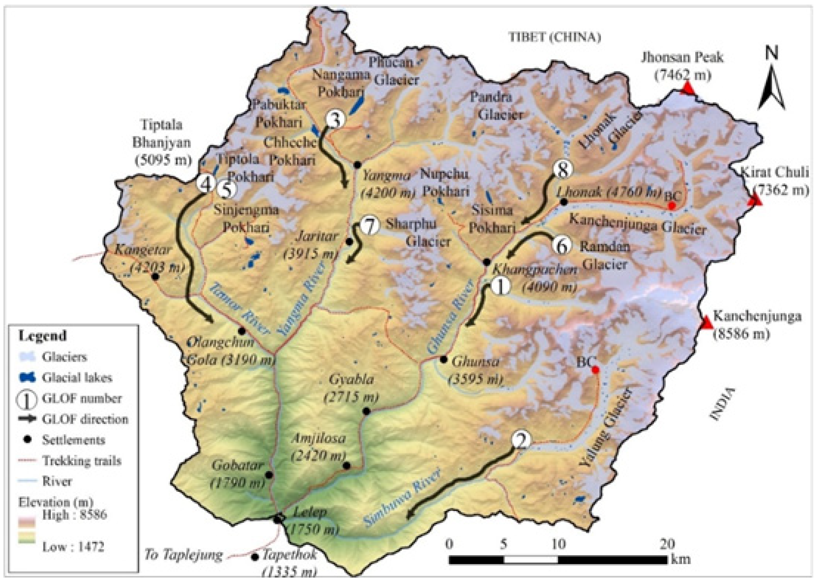
Three major river valleys within the KCA trend roughly south–southwest, and include the Tamor River to the west, Ghunsa River in the center, and Yalung River to the east (
Figure 1). The Tamor River has long been a north–south trade route between Tibet and Nepal, where Tibetan salt was exchanged for grains and other goods from the south [
18]. This trade has declined in importance in recent years because of the availability of nearly all goods (rice,
tsampa, and clothing) from Tibet [
6]. The original inhabitants of the Tamor and Ghunsa valleys are thought to have been of the Magar ethnic group, based upon the existence of ruined forts (
dzong) in the vicinity, who either mixed with or were replaced by the current populations of Limbu and Rai [
18]. At the higher elevations of the KCA, the Magars were replaced by Tibetans/Sherpas several hundred years ago, most likely coming over the Jhinsong La (6164 m) or Chapuk La (~5700 m) passes and into the upper Kanchenjunga glacier valley (
Figure 1). Initially, three houses were established at what is now the village of Kampuchen (4050 m), as large areas of fertile flat river terraces existed at the time that were suitable for growing potatoes. A major glacial lake outburst flood (GLOF) from the Lhonak glacier region in 1921 destroyed most of the river terrace potato fields, forcing most families to relocate downstream to Ghunsa (3427 m) as a result (see Watanabe et al. 2000 [
27] and Byers et al. 2020 [
28]). Tibetan refuges arrived over the various high passes in 1959 when the Chinese invaded Tibet, settling in Phale for about 25 years before moving on to India and Kathmandu in the 1980s.
Khambas, the Tibetan military group who resisted the Chinese until the mid-1970s, also had a camp near Phale, which was abandoned long ago. The third major valley in the KCA, the Yalung, is only seasonally inhabited by agropastoralists from the Yamphudin (1800 m) region to its south, with several tourist lodges available in Tseram (3870 m) and Ramche (4580 m).
Kanchenjunga, known locally as the “five treasures of the sacred snows” [
29,
30], is a sacred mountain that is also believed to conceal a
beyul, or hidden valley of treasure and immortality containing concealed teachings that will be revealed to the devout in times of trouble [
31]. It abounds in sacred sites for the Limbu, Hindu, and Buddhist religions alike, and is also known for its occasional sightings of
yeti (
ban manche,
mi-the), popularly known as the “abominable snowman” (see Nebesky-Wojkowitz 1956 [
32], McNeeley et al. 1973 [
33], Siiger 1986 [
34], Kittle 2007 [
35], Schield 2014 [
30], and Sawerthal and Torri 2017 [
36]). One of our local informants [
37], who claims to have seen a
yeti track near the Nango La about 40 years ago as a young boy, suggests that while the sightings used to be quite common, they have become less so as people spend less and less time in the high
kharkas (yak pastures) and remote areas. Elsewhere, increased population densities and infrastructure development have been cited for the Khumbu [
17] and Kathmandu valleys [
38] as having contributed to a decrease in
yeti, ghost, and spirit encounters in general.
The village of Ghunsa was also much larger 100 years ago than today. At least two of the “pundits”, or indigenous spies trained by the British Raj for clandestine mapping and intelligence work in Nepal and Tibet, reported that in the late 1880s the local monastery had quarters for over 300 lamas (see Freshfield 1903 [
39]). Today, the monastery is only occasionally used, and Ghunsa consists of about 40 homes, a boarding school, clinic, 17 KW hydropower station, and 8 lodges. Most of the population is over 50 years of age, as the majority of young people have migrated to Kathmandu, India, and France in search of new educational opportunities and/or employment.
Sadly, the KCA is also the site of one of the more tragic accidents in Nepal’s aviation history. On 23 September 2006, a Shree Air Mil Mi-8 helicopter crashed into a nearby mountain shortly after takeoff from Ghunsa, killing all 24 passengers and crew onboard. Passengers consisted of high-level government, donor agency, and World Wildlife Fund employees, including many senior members of Nepal’s conservation community, such as Dr. Chandra Gurung, Dr. Harka Gurung, Dr. Mingma Norbu Sherpa, Dr. Tirtha Man Maskey, and Mr. Narayan Poudel (WWF 2006). The group had been celebrating the official turnover of the KCA to local communities, with the departing helicopter taking off under overcast and marginal flying conditions [
40] in spite of the concerns expressed by local villagers [
6].
The KCA is managed by a 12-member Management Council selected by members of its 44 forest-user groups, 32 mother groups, and 7 user committees, the latter representing a mid-level of representation below the upper-level Management Council [
41]. This form of “…decentralized conservation management is believed to increase efficiency [over centralized management in the capital city of Kathmandu], lead to a more equitable distribution of benefits, and decrease time lags in response to the needs of the local residents” [
42]. In fact, the KCA is one of five conservation areas in Nepal that is attempting to alleviate poverty while enhancing biodiversity conservation, usually with mixed results. Parker et al. (2012 [
41]), for example, found that the KCA had failed to develop strategies for livelihood diversification, and Parker and Thapa (2012 [
41]) found that fewer than 20% of households had had any form of contact with KCA-sponsored capacity-building programs. Between May and December 2022, few KCA staff (council members, wildlife monitoring personnel, and field staff) could be found in the region, and the vacancy of most KCA-related structures was conspicuous.
Permits to trek and climb within the KCA are managed and regulated by the Department of National Parks and Wildlife Conservation with a fee paid to the KCAP. Clear and transparent control structures between the Government of Nepal, KCAP, non-government organizations, local user groups, and village political entities, however, are lacking. Parker et al. (2015 [
42]), however, stressed the long-term importance of developing successful management strategies within the KCA, given its position as the first completely decentralized conservation area in Asia. They argue that failure here would cast doubt on the viability of the model throughout the world.
3. Methods
Methods included oral testimony and interviews with local villagers, KCA staff, and adventure tourists [
6] between May and December 2022. Field-based assessments, repeat photography, time-lapse satellite imagery, and glacial lake risk hazard assessment tools [
43] were used for the analyses of potentially dangerous glacial lakes. For the August 2022 ice-debris avalanche study in the Nupchu valley, historic satellite imagery and oblique photography were employed, and numerical simulations of avalanche volumes were conducted using R.Avaflow version 3 [
44], a state-of-the-art software that has been used globally to study ice/rock avalanche events [
45]. For the historical GLOF analyses within the KCA [
46], CORONA and Landsat 2 and 5 data platforms were conducted after the oral testimony field phase to determine if flood-related landscape features could either support or challenge the local reports of contemporary and historical flood occurrence. Alpine and subalpine vegetation were assessed via 10 × 10 m quadrat sampling, field observations, and plant collections for the National Herbarium at Godavari, Lalitpur, Kathmandu.
Collectively, the information acquired above was designed to provide insights into two fundamental research questions, i.e., (a) what opportunities exist for the KCA to minimize the negative aspects of change while maximizing the positive? And (b) how could the KCA emerge from these changes and transitions with the most promising, economically beneficial, and environmentally sound future possible?
The following sections discuss contemporary change and opportunities within the KCA under the categories of traditional livelihoods, roads, climate change, adventure tourism, wolf and snow leopard depredation, and vegetation.
3.1. Traditional Livelihoods
As with many other remote regions of Nepal, young people have been leaving the KCA for employment opportunities in Kathmandu and overseas since the early 1990s (see Childs et al. 2014 [
47] for similar trends reported for the north-central Nepal region), a process that intensified during the Maoist insurgency (1996–2006) [
48,
49]. Older people now represent most of the remaining inhabitants within the main villages, such as Ghunsa, for example, with the exception of a few younger lodge owners who can still make a comfortable living from the tourism trade. The unprecedented growth in cellphones, internet, and social media in the KCA during the past decade provided affordable access to critical scientific and lifesaving information during the COVID-19 pandemic and the 2015 Gorkha Earthquake [
50]. At the same time, the technologies have also facilitated greater exposure to western popular culture, with mixed results, as has been reported for elsewhere in Nepal [
51].
Agriculture and yak breeding represent the traditional lifestyles in the higher altitudes of the KCA (see Hooker 1854 [
52], Freshfield 1903 [
39], and Thapa 2009 [
18]), although both appear to be decreasing in importance because of changing lifestyles, aspirations, and markets. For example, most villages above 3000 m have traditionally grown barley, wheat, buckwheat, and potatoes [
18], where only potatoes are now grown in addition to vegetables and greens for the tourist market. Most people seem to regard a combination of tourism and remittances from family working overseas as two of the region’s most promising options for future economic growth and sustainability, and many are already employed by the growing number of tourist lodges. There are also hopes that greenhouses, vegetable growing, cottage industries, and other tourist-related activities can augment or replace the former agropastoral lifestyles.
In recent years, traditional yak herding and yak numbers have declined dramatically in response to (a) labor shortages, (b) changing lifestyles and preferences, (c) new educational opportunities and pursuits for younger generations, and (d) the selling of herds in response to the demand and high prices paid for meat in Tibet. Spending a monsoon in a cold and wet
kharka is no longer mandatory nor desired by younger generations, forcing a family’s older members (e.g., grandparents) to increasingly assume this role. Yak and
dzopkio herders interviewed during the monsoon of 2022 all had children in school in Taplejung, Kathmandu, and/or India, and the probability of these young people returning to a lifestyle similar to that of their parents is small. In 2022, a large male yak could command upwards of Rs. 100,000/- in Tibet, and their sale was so lucrative that herds are sometimes brought over from Sikkim, into the KCA, and on to Tibet for sale. In terms of decreasing livestock numbers, Sherchan and Bhandari (2017 [
26]) reported a total of 509 yaks and yak hybrids for the Ghunsa valley in 2013, which had decreased to approximately 195 animals in 2022. For the Yangma valley, similar decreases were reported [
53].
3.2. Roads
Beginning around 2005, the Government of Nepal launched an ambitious plan to construct a network of roads throughout the country that would provide rural residents with roadheads no more than 4 h walking distance from every village (Pokharel and Acharya 2015 [
7]). This was mandated without apparent regard to local settlement patterns, cost–benefit, geo-hazards, or topography. Between 1998 and 2016, the construction of national-level roads grew from 4740 km to 15,404 km, and local-level roads from 4780 km to 57,632 km (Sudmeier-Rieux et al. 2019 [
9]). An additional 11,265 km of new, hastily constructed gravel or dirt roads were constructed between 2017 and 2018 [
54]. Recent governmental directives continue to emphasize major road construction for both increased north–south connectivity and to boost trade with neighboring countries [
55].
The perceived and promoted benefits of roads typically include increased access and connectivity for rural populations, employment opportunities, population growth, and access to healthcare, among others [
56]. Detrimental impacts, however, such as increased environmental hazards (notably landslides), pollution, crime, and unwanted cultural influences, have been largely ignored by both the government and local populations alike [
57,
58,
59,
60,
61,
62,
63,
64]. Meanwhile, roads are increasingly encroaching into Nepal’s national parks and protected areas, with little evident concern for the impacts on biodiversity or local economies dependent upon adventure tourism [
65] (
Figure 2,
Figure 3 and
Figure 4).
The overall national road building trends described above are clearly visible within the Taplejung District as a whole, including within the KCA boundaries (
Figure 2 and
Figure 5). Although the paved road from Ilam to Taplejung was built at least 20 years ago, unimproved roads within the vicinity of Taplejung have proliferated within the past 5–10 years (
Figure 5). Two roads from Taplejung to points north have also been constructed, with one descending to the Tamor Khola that provides access to the 73 MW Middle Tamor Hydropower Project near Mitlung village, currently under construction. The second heads due north from Taplejung to the villages of Gaididanda and Phurumbu, descending to meet the river road and Middle Tamor Hydropower project near Mitlung. These roads and their spurs will eventually provide access to two other hydropower projects under construction, i.e., the 78 MW Ghunda Hydropower Project at Japantaar (powerhouse) and Lamatar (damsite), and the 68 MW Remit Simbuwa Hydropower Project between Helok and Torongden (
Figure 5, right). From Sekathum, the road continues north, where it will eventually connect with Olangchungola, where a Chinese-built road from Olanguchola over the Tiptola Pass (5095 m) to Tibet already exists (
Figure 5, right). Other proposed roads include from the Tamor/Ghunsa confluence north to the remote village of Yangma, from Lamatar to Gyabla along the Ghunsa Khola, and from Gyabla to Ghunsa. Spur roads of less than half a kilometer connect various villages to the main road along the way (
Figure 5, right).
Many traditional trekking and mule trails have now become roads, such that much of the Great Himalayan Trail is rapidly becoming the Great Himalayan Road.
As has occurred elsewhere in Nepal, vehicular access along the Tamor Khola, e.g., from Ramite (2685 m) to Yangma (4220 m), could put the region’s old growth juniper and fir forests at a greater risk to large-scale logging, extraction, and lumbering operations (
Figure 4, [
54,
65]). Formerly remote alpine valleys, home to valuable medicinal plants, will be able to be accessed within a day’s walk, facilitating a much larger-scale extraction than was possible in the past [
65]. Poorly constructed roads upon naturally dynamic hillslopes have already resulted in chronic and deadly landslides each monsoon season [
56].
Within the KCA core area itself, an unimproved track has already been constructed from Tapetok to Japantar, and plans for its extension to Gyabla, and eventually to Ghunsa, were being widely discussed by local people during the fall of 2022. An extension of the road to Ghunsa will assuredly destroy a number of important riverine biodiversity hotspots, such as the richly diverse temperate mixed forests between Gyabla and Phale that provide critical red panda habitats. The proposed road could also impact the currently pristine nature of the Ghunsa Khola trail, and most likely reduce the numbers of adventure tourists to the region. Nearly all trekkers interviewed in Ghunsa in the fall of 2022, for example, claimed that the reason they chose the KCA was some variation of “it’s one of the last regions in Nepal that hasn’t been destroyed by roads”. As mentioned previously, the expansion of adventure tourism is a high priority among local communities, demonstrated by the recent construction of numerous new lodges throughout the KCA. This priority clearly needs to be factored into any plans and discussions that promote the concurrent introduction of new roads into the region.
3.3. Climate Change
Climate change has had a profound impact on Nepal’s cryosphere [
66,
67,
68], and the KCA is no exception. As is the case for most stagnating glaciers in the Nepal Himalaya, KCA’s valley glaciers are largely debris-covered, with increasingly exposed ice and abundant meltwater pond formations, and have been retreating since at least the end of the Little Ice Age around 1850. The botanist, Hooker, for example, wrote in 1849 of observing glacial moraines that provided proof “…of glaciers having once descended to from 8000 to 10,000 feet in every Sikkim and east Nepal valley…” (Hooker 1854 [
52]: 166). The British alpinist Freshfield (1903 [
39]: 236) writes of the “glacial shrinkage” he encountered in the Lhonak region in 1899, as well as throughout both the Nepal and Sikkim sides of the Kanchenjunga massif. As of 2015, debris-covered valley glaciers and higher-altitude clean mountain glaciers within the KCA covered an area of 488 + 29 km
2, with an overall negative glacier surface area loss of 0.5 + 0.2% yr
−1, based upon an analysis of 1962–2000 Landsat ASTER imagery [
69]. Because the imagery used in the Racoviteanu et al. (2015 [
69]) study is now more than 24 years old, it is reasonable to assume that ice and glacier coverage today has since been significantly reduced. All of these are indicators of the impacts of contemporary warming trends upon glaciers that include increased debris cover, meltwater ponds, englacial conduits, recently exposed ice surfaces, and the breached terminal moraines of previous low-elevation glacial lakes (see Ishikawa et al. 2001 [
70]).
Although the Kanchenjunga region was the center of the earliest botanical, exploration, and mountaineering expeditions to Nepal by outsiders, relatively little glacier and glacier hazards research has been conducted to date. Until 2019, for example, only one GLOF in the KCA had been studied [
71] and recorded in GLOF inventories [
72]. Subsequent research, using a combination of oral testimony and remote sensing, suggested that at least seven others had occurred in the KCA since 1921, as shown in
Table 1. As mentioned previously, a particularly devastating flood in 1921, originating in the vicinity of the Lhonak glacier, destroyed several hectares of potato fields adjacent to the village of Kampuchen (
Figure 6).
Throughout the region, the abundance of breached or incised terminal moraines of basins that no longer contain water is testimony to their progressive and/or rapid drainage at some point in the recent past (
Figure 7). Progressive drainage results in the solid load being transported over a longer distance than an abrupt drainage event, with the coarser material deposited closer to the breach area, while smaller material is transported further downstream. In contrast, the rapid release of stored lake water will abruptly release all sizes of material due to the rapid breaching of the dam, which in turn can be carried for longer distances than that from a progressive breach. The size and texture of remaining debris at the foot of the terminal moraine can thus provide a rough approximation of the nature of the drainage activity, i.e., progressive large (1 m+) and coarse material indicating rapid drainage, with small and more rounded material indicating a slow and steady drainage process ([
73]; see also Korup and Tweed (2007) [
74], Knight and Harrison (2014) [
75], and Westoby et al. (2014) [
76]).
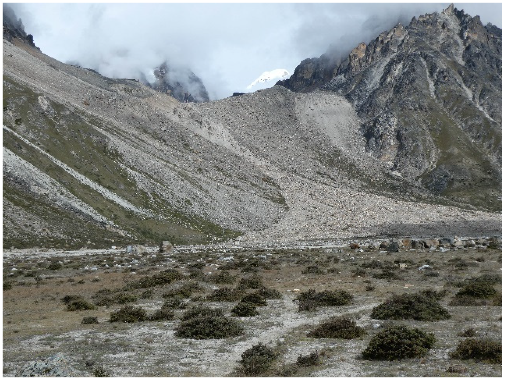
In Kampuchen, villagers have long claimed that the 0.129 km
2 Nupchu Pokhari (27°47′26.55″ N; 87°56′03.39″ E) at the head of the Nupchu valley (
Figure 8) was extremely dangerous in terms of its likelihood of flooding. Our field reconnaissance of 1–20 September 2022 suggested that the glacial lake presents a moderate risk due to the absence of potential triggers (e.g., overhanging ice and other lakes at higher altitudes). This assessment was corroborated by Rounce et al. (2017 [
43]), who concluded that Nupchu glacial lake was only moderately dangerous because of (a) no apparent growth between 2000 and 2015, (b) absence of avalanche pathways into the lake (i.e., in line with the direction of the lake and its outflow), and (c) absence of landslide pathways entering the lake [
6,
77].
Studies on high-altitude permafrost, geomorphic activity, and cryospheric hazards are limited for the KCA, commencing only in the early 2000s (e.g., Watanabe et al. 2000 [
27]; Ishikawa et al. 2001 [
70]; Watanabe 2006 [
78]; Regmi and Watanabe 2005 [
79], 2009 [
77]). A more recent event of some note occurred between 16 and 24 August 2022, when a large ice-debris avalanche in the Nupchu valley occurred that covered an area of 0.6 km
2, with a total estimated volume of one million cubic meters of debris, covering a historic debris cone of unknown age (
Figure 8,
Figure 9 and
Figure 10). Based upon an analysis of satellite imagery, a series of small-to-medium, torrent-like pulses commenced in December of 2020, indicating higher altitude ablation activity that may have been related to contemporary changes in permafrost and ice/snow integrity. Fortunately, no humans nor cattle were killed during the 2022 event, although such changing cryospheric conditions may indicate the need for vulnerable villages to consider the installation of preventative floodwater diversion mechanisms [
6,
46]. Other indicators of accelerated geomorphic activity related to climate change include the rapid erosion of trails, such as the trail from Lhonak to the Kanchenjunga north basecamp, due to the mass wasting of Pliocene terraces and moraines paralleling the adjacent glacier [
6]. New trails will need to be constructed within the very near future, as has been the case for popular trekking trails in the Mt. Everest region for at least the past decade.
3.4. Adventure Tourism
In a process that accelerated in the 1970s, Nepal has become globally renowned as a center for trekking and mountaineering. Thousands of kilometers of centuries-old trails climb through the small Himalayan country’s remote and roadless regions, meandering up valleys that bisect such romantic 8000 m+ giants as Everest, Annapurna, and Kanchenjunga. For more than 60 years, millions of trekkers, scientists, and adventurers have been attracted to Nepal’s unique bio-, cultural, and physical diversity, which features bio-climatic and vegetation transitions from subtropical to alpine within a few dozen kilometers, and more than 125 distinct ethnic groups—all within a country of less than 150,000 km2 in area. The late 1970s also saw the initiation of Nepal’s system of national parks and protected areas, which now encompasses 23% of the country’s land area.
The Kanchenjunga region has been referred to as the “birthplace of modern tourism in Nepal” (Thapa 2009 [
18]) because it was among the first destinations in Nepal to receive botanical, clandestine mapping, and mountaineering expeditions from abroad. The English botanist, J.D. Hooker, for example, with permission from the Maharajah of Nepal, traveled throughout the Tamor, Ghunsa, and Yangma River valleys in 1849 [
52]. The “Pundit”, Sarad Chandra Das, visited the region in 1879, following the Chabuk glacier north and crossing what was most likely the Chabuk La into Tibet, as opposed to the Jhinsang La (6164 m) that he claimed to have crossed (see Freshfield 1903 [
39]). Chandra Das was followed by another pundit in 1884, Rinzing Namgyal, who completed the first recorded circumambulation of the Kanchenjunga massif [
39]. In 1899, the British mountaineer, Sir Douglas Freshfield, replicated Rinzing’s 1884 circuit of Kanchenjunga, accompanied by Rinzing as his expedition guide, the Italian photographer, Victorio Sella, Sella’s brother, Ermmio, professor of geology Dr. Edmund Garwood, and a young climbing Italian guide named Val Tournanche [
39]. Freshfield’s journey was illegal, as it had not been approved by the Nepal Government, resulting in a rather hurried return from Ghunsa into Sikkim via the Selele (4480 m) and Khang La (5200 m) passes (
Figure 1).
Mountaineers were to make up the next group of visitors to the region, all of whom hoped to summit Kanchenjunga, which, at the time, was considered to be a more prestigious achievement than the higher Mt. Everest because it was much more difficult [
16]. Beginning in 1905 with the British mystic Aleister Crowly [
16], a number of unsuccessful attempts were made by primarily British and German teams for the next 50 years. Kanchenjunga was first successfully summited in 1955 by George Band and Joe Brown of the U.K. Their expedition was led by Sir Charles Evans, who had been deputy director of the successful 1953 British Everest Expedition [
16]. As of 2018, only 312 climbers had summited Kanchenjunga [
80].
Other noted visitors include the Tibetan lama and holy man, Tulshuk Lingpa, who in 1962 led a group of some 300 spiritual followers from Sikkim, Nepal, and India into the Yalung valley from Sikkim in search of the Kanchenjunga
beyul (sacred and hidden valley that had been created in Guru Rinpoche in the 12th century (see Shor 2011 [
31])). Unfortunately, Lingpa was killed in an avalanche while attempting to locate the
beyul somewhere in the vicinity of the Kanchenjunga South Basecamp the same year.
Trekking tourism began in 1984 when the region was first opened to foreign groups (Walkey 2013 [
81]) and has averaged several hundred tourists per year since 2010 (
Figure 11). Tourism has been limited when compared to other MPAs in Nepal, e.g., the Sagarmatha (Everest) National Park, which received 57,739 foreign visitors in 2018 [
82]. In the KCA, tourist numbers averaged 546/year in the pre-COVID-19 years between 2010 and 2020, dropping to 43 in 2020/2021 with the onset of COVID-19. Trekker numbers were clearly rebounding during the spring and fall of 2022, with 710 recorded by the Ghunsa Police Checkpost [
6]. However, the total number of tourists annually remains more or less equal to those arriving in the Mt. Everest region on a single day (see Byers 2013 [
82]), as access to the Kanchenjunga region is much more difficult and time-consuming by comparison. Most trekkers visit the Kanchenjunga North and South basecamps situated within the Ghunsa and Yalung valleys, respectively.
In spite of low visitation numbers, the impacts of tourism upon the landscape are becoming readily visible. The past 25 years have seen a dramatic increase in the number of tourist lodges, e.g., from one to eight in the village of Ghunsa between 1997 and 2022 (
Figure 11 and
Figure 12), and from one to five rustic lodges in Lhonak (4780 m) between 1997 and 2019, with six higher-quality lodges (total of eleven) constructed during the COVID-19 years (2020–2022). Additionally, the slow-growing shrub
Juniperus indica is the primary fuelwood type used by the 11 Lhonak and 4 Kampuchen lodges observed, gathered from the surrounding alpine hills. In other regions of Nepal, unregulated shrub juniper harvesting for fuel, usually linked to an increased demand for fuelwood as a result of growing tourist numbers, has been shown to cause rapid alpine ecosystem disturbances. The removal of the shrub’s protective foliage, soil binding roots, and increased exposure of bare soils can result in accelerated erosion, as well as general landscape degradation [
83,
84,
85,
86]. In a 2019 survey of fuelwood in Kampuchen, a total of 48.56 m
3 of shrub juniper was found stacked outside of the lodges and two private houses that make up the former
goth, in addition to 22.21 m
3 of birch and tree rhododendron brought up from the lower altitudes. How much fuelwood is needed throughout a full year is unknown, although it is reasonable to assume that it is many times the above volumes and weights.
While the use of birch and tree rhododendron from lower elevations is not necessarily a cause for concern at present, the totals recorded for Kampuchen equate to many thousands of kilograms of live shrub juniper harvested annually from the Kanchenjunga alpine zone. Stockpiles of shrub juniper, scattered piles left to dry, and alpine turf for wall construction were observed being mined in all alpine villages and
goths visited in the KCA. The KCA is blessed with a wet climate, which studies have shown creates a more forgiving, resilient alpine vegetation and landscape [
86], and it could be argued that local people have made copious use of the shrub for several hundred years at least (see Hooker 1854 [
52]). However, with the current levels of tourist lodge construction and the anticipated increase in tourist numbers, this practice could eventually cause major alpine landscape degradation in the region, as has occurred in the upper Imja valley of Khumbu [
83] and Hinku valley of Makalu-Barun [
86]. In both Khumbu and Makalu, however, fuelwood substitutes, such as kerosene, LPG gas, solar, and small hydro, are now being utilized with success, which the KCA should be encouraged to follow.
Finally, during the past two decades, cement has become an increasingly popular building material throughout Nepal, whether there is road access or not. In addition to general building construction, cement is also being increasingly used at cultural and religious sites, e.g., the new mandir constructed entirely of cement at the Phaktanglung boulder near Kampuchen, or the staircase leading to an 800-year-old gompa in Olangchun Gola. Both Nepali and foreign visitors were frequently heard to say that cement is unsightly, detracts from the overall beauty of the site, and obscures thousands of years of indigenous building technologies. Maintaining traditional building and restoration technologies and methods throughout the KCA may, in fact, be in the best interests of promoting religious, adventure, and cultural tourism in a region that is already undergoing tremendous change because of outmigration, new communication technologies, globalization, and other factors.
3.5. Wolf and Snow Leopard Depredation
In 2017, we observed Tibetan wolf scat and tracks in the upper Thame valley of Sagarmatha National Park, the first time that wolves had been present in the Khumbu for many decades. The return of wolves was linked anecdotally to several possible factors, including hunting pressures in the Tibet Autonomous Republic (TAR), a group of wolves that may have followed a yak train coming back from the TAR in 2014 [
87,
88,
89,
90], the decrease in snow and ice upon the high passes between Nepal and the TAR, and the recent construction of new roads that now cross many 5000 m passes, all of which could have influenced and encouraged wolf migration into Nepal.
Two years later, during our first field expedition to the KCA in April and May of 2019 (see [
28]), villagers throughout the region were also complaining of the recent re-introduction of wolves from the TAR to the north, whose tracks and scat we found in abundance in the upper Ghunsa valley as confirmation. As in Khumbu, it was widely believed that wolves returned to the KCA by following local traders back from Tibet around 2012, crossing over several little-used passes to the north. Additionally, yak herders and traders in the TAR are reportedly provided with trucks and motorcycles, which give them distinct advantages over their KCA counterparts in protecting their domestic herds from wolves and other predators. Likewise, TAR wildlife managers, the army, and the police can reportedly shoot and trap wolves on sight with limited restrictions, something that is prohibited in the KCA. It is thus possible that with the higher hunting pressures, road development, and more difficult prey in the TAR, wolves have simply started migrating south to conditions more agreeable for their survival.
According to data from the Ghunsa Snow Leopard Conservation Council (SLCC), wolves have killed nearly twice the number of livestock compared to those killed by snow leopards between the years 2013 and 2022, with 76 attributed to wolves and 36 to snow leopards (
Figure 13). These figures may, in fact, be underestimates, since they reflect the number of animals claimed for compensation, and not the actual numbers of livestock (i.e., yaks, sheep, horses, etc.) preyed upon [
91,
92,
93].
Despite the high levels of national and donor support for the local management systems of the KCA, the actual effectiveness of herder user group insurance schemes is difficult to assess. Complications include the differing compensation programs between differing village committees, local participation levels, pooled liquid capital, unclear depredation datasets, discrepancies between insurance compensation and the actual value of livestock, and outmigration of traditional herders for more lucrative employment elsewhere. Likewise, data from the TAR, directly across the border from the KCA, show that Chinese compensation programs for yak herders with losses to snow leopards and wolves are also not working, largely because of similarly confusing and insufficient compensation mechanisms [
90].
In the Annapurna Conservation Area (ACAP), Tiwari et al. (2010) [
91] found that the perceptions of carnivores by herders rapidly turned negative as predation rates increased, with no clear compensation systems in place, even though the herders agreed that conservation in general was important. Additionally, the labor shortages created by young people leaving the ACAP region served to exacerbate existing yak and predation issues (Tiwari et al. 2010) [
91]. Both of these studies highlight the ongoing difficulty of developing effective animal predation insurance programs within MPAs, and the continued need for finding workable solutions to the age-old problem of people/wildlife conflicts (e.g., see Jackson 1990 [
92]).
Sherchan and Bhandari (2017 [
26]) reported that predation rates due to snow leopards and wolves began to increase in the KCA during the 2013/2014 period, which coincides with the SLCC reporting of increased wolf predation in the Ghunsa herding areas (
Figure 13). Although retaliation killing of snow leopards by yak herders has reportedly happened fairly frequently in the past [
94], no recent killing or poaching (i.e., as of 2022) is known to have occurred in the KCA. Blue sheep in Yangma valley, however, are reportedly hunted by poachers every winter [
95].
Wolves themselves are not known to be profitable nor even desirable animal to poach. Wolf killings by herders have most often been in response to excessive predation of a yak herd, or out-of-the-ordinary aggressiveness by specific wolves. Additionally, wolves are reportedly easily scared when confronted with herding dogs, alert herders, and even children [
96]. During interviews conducted in Ghunsa in 2022, many herders voiced frustration at their own labor shortages and the inability to keep watch over herds that are vulnerable to predators, especially when calving.
Our research team found fairly abundant evidence (tracks, scat, and scrapes) of both snow leopards and wolves in the Kampuchen and Lhonak regions of the Ghunsa valley, and of snow leopards in the upper Yalung valley both in 1997–2002 and in 2020–2022. The abundance of blue sheep throughout the higher elevations of the KCA [
94], and decreasing numbers of yaks and yak hybrids, could also be contributing to recent decreases in livestock depredation. As wolves have been shown to be a high alpine meadow predator that prefers not to hunt on steep slopes [
91], the reduction in yak herds in the area could also be a significant factor in population size and migration. Insights into contemporary snow leopard and Tibetan wolf issues will hopefully develop from the recently constructed Snow Leopard Research Center, with offices and housing for researchers being constructed above the village of Kampuchen (
Figure 14).
3.6. Vegetation Change
Increases in wildlife depredation of livestock and crops in general (e.g., by bears, civet cats, and red dog (
dhole)) have been linked to the increasing numbers of abandoned farms and the increase in second-growth forest [
26]. Elsewhere in Nepal, the return of forests over the past 40 years has been largely attributed to the success of community forestry programs initiated in the 1990s [
97,
98,
99,
100,
101,
102,
103], where local control has reportedly been more effective than previous and traditional top-down management systems. However, attributing community forestry alone to the “greening of Nepal” ignores the important contributing factors of outmigration, farm abandonment, and subsequent growth of pioneering tree species, such as alder [
26,
101]. Increases in successional forest cover in the temperate zone, and of shrub cover in the alpine, will most likely continue within the KCA for the foreseeable future as a result of farm abandonment, decreases in yak/
dzopkio populations, and global warming trends. That is, decreases in livestock numbers, grazing pressure, and fuelwood harvesting pressure, coupled with increases in regional warming trends, will most likely result in a higher density of shrubs in the KCA’s alpine ecosystems within the near future (see Anderson et al. 2019 [
102]), and possibly less habitat for medicinal and aromatic plants [
103].
In the vicinity of most villages from Gyable to Ghunsa and beyond, most of the larger Himalayan fir trees (
Abies spectabilis), a “Near Threatened” species according to the IUCN Red List (
https://www.iucnredlist.org/species/42300/10686224, accessed on 11 November 2023), have been removed over the past several decades for construction purposes, facilitated by the recent introduction and use of chainsaws. As a result, fir is conspicuously absent in the remaining rhododendron/fir/juniper forests that surround many villages, and large stumps on both sides of the Ghunsa river valley attest to a former abundance of fir trees. The regular burning of fir forests at the tree line, most likely to increase the pasture area, was also observed, which creates additional stresses to the species’ propagation.
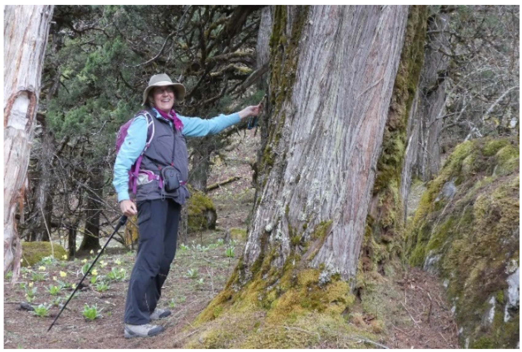
Alpine shrub juniper and dwarf rhododendron were found to be in good condition in spite of the hundreds of years of harvesting by yak herders and villagers for fuel and incense (see Hooker 1854 [
52]). This is perhaps reflective of the wet environments found in the KCA, which tend to be more forgiving of disturbance than dryer environments, such as the Sagarmatha National Park [
65].
Medicinal and aromatic plants (MAPs) appear to be heavily harvested throughout the KCA, without any apparent or enforced quotas or restrictions. For example, Rheum nobile (padamchal or “lemonade plant”) has been nearly extirpated. Likewise, small, isolated populations of the rare and threatened Nardostachys grandiflora (spikenard or jatamansi) were observed being heavily harvested by individual households, who did not seem to be aware of its globally rare status and dwindling populations.
4. Discussion
Collectively, the majority of the contemporary changes described above are unprecedented in the history of the KCA region, and they have occurred faster than anyone could have imagined even 10 years ago. The consequences of such rapid change are difficult to predict with certainty, but as experienced elsewhere in Nepal, they will assuredly be mixed. What, then, are the opportunities for the KCA to minimize the negative aspects of change while maximizing the positive? How could the KCA emerge from these transitions with the most promising, economically beneficial, and environmentally sound future possible?
One possible response is that the KCA, regardless of the rapid onslaught of change, still has time to assess the feasibility of proposed interventions before they are constructed, such as new roads and environmentally unsound development. For example, as an alternative to constructing roads throughout the currently roadless and biologically rich Ghunsa and Yalung valleys, the KCA could choose to remain a “traditional” protected area, where only foot and beast of burden travel occurs, thus making it unique in Nepal’s rapidly diminishing roadless MPAs. KCA would continue to remain a draw for the traditional adventure tourist (remote area trekkers and mountain climbers), whose numbers would likely increase as similar options elsewhere in Nepal vanish. Additionally, new international and historic trekking routes between Nepal, China, and India could be developed that would further the region’s national and international appeal to adventure tourists. The increased visitation would directly benefit local cottage industries that could include handicrafts, fresh vegetable production, milk and dairy products, pack animal (e.g., dzopkio) rental, and others. A functioning natural history museum in Ghunsa and elsewhere could educate visitors about the rich and unique flora and fauna of the KCA region.
Meanwhile, three other areas of concern in the KCA that could be systematically and concurrently addressed include the growing (a) use of shrub juniper as fuelwood in alpine regions, (b) presence of landfills for solid waste disposal, (c) numbers of beer bottles accumulating in the vicinities of lodges, and (d) abundance of litter in the vicinities of villages, usually wind-blown from landfill areas. In the Sagarmatha National Park, for example, local community groups have banned the use of shrub juniper for fuel throughout the upper Imja Khola region since the mid-2000s, including its use in the Everest basecamp for
puja (expedition blessing and ceremonial) purposes [
83]. Solid waste management systems based upon the principles of recycling, reducing, and reusing have also been developed for the Sagarmatha National Park (see Byers et al. 2020 [
82]), which the KCA could be encouraged to review and incorporate into its overall management strategies before the situation reaches the critical levels currently being experienced in many of Nepal’s other protected areas. Likewise, glass beer bottles are not currently banned from entering the KCA, and no system of transporting empty bottles out exists. Litter, especially in Lhonak and Ramche, is a cosmetic but also unsightly phenomenon that usually has its origins in uncovered landfills, which could also be addressed by lodge owners and local authorities by encouraging local youth groups or lodge owner associations to conduct annual clean-up campaigns (see Byers 2013 [
82]). As an alternative to the use of cement and other modern building materials, the KCA could remain a center of traditional Nepali architecture and culture, which is rapidly becoming a rarity throughout much of Nepal. The KCA could also capitalize on its unusually large herds of blue sheep, snow leopards, wolves, birds, wildflowers, and natural phenomena to adopt an eco-tourism approach and become a “center of high mountain biodiversity,” with functioning museums, natural history guides, and interpretative signboards along some trails.
The changing cryospheric conditions throughout the KCA suggest that vulnerable villages may wish to consider the installation of preventative floodwater diversion mechanisms, such as the rock-filled gabions used with success in flood-prone regions throughout Nepal [
12]. Improved reporting mechanisms to authorities, the development of appropriate early-warning systems, and more systematic monitoring of potentially dangerous glacial lakes could also help to prevent or mitigate future damage to villages, agricultural land, and other infrastructure (see Byers et al. 2024 [
46]).
Although the likelihood of the opportunities mentioned above being adopted is difficult to assess, the alternatives are easy to envision. That is, in the absence of any systematic planning, and broad adoption of a committed conservation ethic, roads will most likely be bulldozed throughout the KCA within the next several years, perhaps as far as the alpine (>4000 m) destinations, such as Kampuchen and Lhonak. Some roads will ultimately be abandoned because the cost of landslide maintenance will exceed local budgets. Adventure tourist numbers will plummet as they have in other regions of Nepal, such as the Annapurna Conservation Area (ACAP), where the formerly large numbers of “around Annapurna” trekkers have now been replaced by urban and motorized tourists who rarely venture far from their hotels. Wildlife and native plant populations and forest cover will suffer due to increased vehicular access, and the challenge of controlling illegal sales in plant and animal parts will increase. Villages will become homogenized in architectural style as traditional homes are replaced by modern lodges, restaurants, and vehicle repair shops. KCA, similar to many regions of Nepal, will assuredly enjoy some benefits from these changes, but it will also need to develop strategies to cope with the inevitable, and often surprisingly negative, impacts.
5. Conclusions
Similar to many MPAs in Nepal, the KCA is currently undergoing a series of environmental, social, and economic changes that are unprecedented in the region’s history. They include changes in traditional social and economic lifestyles, road construction into previously roadless areas, increased cryospheric hazards due to climate change, transformations in traditional adventure tourism, changing architecture and construction methods, and disturbances to wildlife/forests/medicinal and aromatic plants. What the long-term impacts of these processes will be is difficult to predict. However, while similar changes are occurring in MPAs throughout Nepal, it is suggested that the KCA retains the option of conducting detailed feasibility, environmental, and impact assessments prior to the implementation of major change-associated projects, particularly the construction of roads. In turn, the KCA might avoid many of the environmental, social, and economic problems experienced elsewhere in Nepal, while enhancing its status and income-generating capacities as a destination for adventure, nature, and cultural tourism. At the very least, the potential impacts of new roads upon the adventure tourism, wildlife, medicinal and aromatic plants, and other sectors should be evaluated and discussed with local communities, KCA user groups, KCA officials, and the DNPWC prior to their construction, and their costs/benefits should be systematically weighed.


 ,
, 


