Article

Geoscience for Cities: Delivering Europe’s Sustainable Urban Future

1
Environmental Science Centre, British Geological Survey, Keyworth NG12 5GG, UK
2
Czech Geological Survey, Klárov 131/3, 118-21 Prague, Czech Republic
3
Geological Survey of Denmark and Greenland, DK-1350 Copenhagen, Denmark
4
Italian Institute for Environmental Protection and Research, Geological Survey of Italy, Via Vitaliano Brancati, 60-00144 Roma, Italy
5
Geological Survey Ireland, Booterstown Hall, Booterstown, Blackrock, A94 N2R6 Dublin, Ireland
6
Polish Geological Institute-National Research Institute, 4, Rakowiecka Street, 00-975 Warsaw, Poland
7
Lyell Centre, British Geological Survey, Edinburgh EH14 4AP, UK
8
Geological Survey of the Netherlands, Princetonlaan 6, 3584 CB Utrecht, The Netherlands
9
Department of Earth Sciences, Faculty of Science, Vrije Universiteit Amsterdam, De Boelelaan 1085, 1081 HV Amsterdam, The Netherlands
10
Geological Survey of Norway, P.B. 6315 Torgarden, 7491 Trondheim, Norway
*
Author to whom correspondence should be addressed.
Sustainability 2024, 16(6), 2559; https://doi.org/10.3390/su16062559
Submission received: 13 November 2023 / Revised: 17 December 2023 / Accepted: 21 December 2023 / Published: 20 March 2024

Abstract

:
European Union (EU) policy is clear in its ambition to deliver a sustainable urban future for Europe. In this paper, we consider the role of urban geoscience to help achieve these ambitions. We highlight the relevance of geology to urban subsurface planning and wider EU policy and strategy. Despite the lack of explicit mention of urban underground space in key policy documents, we identify a significant number of priority urban issues for which geological characterisation is a pre-requisite and for which the geological system forms part of the solution, such as mitigation of climate impacts, delivering net zero energy, and implementing nature-based solutions. We reflect on the paradigm shift of urban geoscience as a geological discipline, rooted initially in engineering geology but which has moved towards an interdisciplinary, solution-focused science operating at the inter-section of environmental–social–built systems. In this regard, we highlight cutting-edge urban geoscience research aligned to current urban challenges and note, in particular, the significance of digital technologies to enable 3D urban characterisation, support data-driven decision-making for planning and development, and serve as a means to communicate geology to urban practitioners. The role of the urban geoscientist as an agent of change to enhance integrated science, improve the accessibility of geological issues, and accelerate the translation of national–regional geology to local settings and to urban policy drivers should not be underestimated.

1. Introduction

By 2050, it is likely that we will have developed into a predominantly urban species, with 70% of the global population expected to be living in cities and the surrounding urban sprawl [1]. In Europe, whilst population density is highly variable between countries, the urban population is already high, ranging from around 60% in, e.g., Poland to up to 88% in Sweden, 92% in The Netherlands, and 98% in Belgium [2] (Figure 1). Urbanisation, in particular the development of large towns and cities, is, however, an important route to economic stability, where cities become the foci for innovation and learning, distributed services, and national and global financial investment. In Europe, cities account for between 27% and 60% of national gross value added (GVA) (2011), with the economies of some countries dominated by one city, such as London in the UK, Dublin in Ireland, and Sofia in Bulgaria [3] (Figure 1).
Whilst cities deliver economic benefits, high urban populations are placing extreme pressures on land, the environment, and natural resources and are major contributors to climate change [4]. The relationship between population growth, urban expansion, and resource use is non-linear, meaning the impacts of urbanisation on the wider environment are increasing non-linearly [5]. For example, the rate of demand for water has been twice the rate of population growth in recent decades [6], and water allocation from agriculture to urban centres has become a common strategy to meet freshwater needs in growing cities [7]. Moreover, human activities, such as land-use change, substantial water withdrawals, and wastewater discharge, can have a greater impact on the water cycle than climate change, causing changes in the qualitative and quantitative state of both surface water and groundwater [8,9]. While urban centres only cover approximately 3% of the land surface, they account for more than 70% of energy consumption and 75% of carbon emissions [4]. The impact of urbanisation, therefore, extends far beyond its physical footprint.
Whilst cities are the problem, as centres of innovation, knowledge, and economic prosperity, they must also be a solution. Global programmes including the UN Sustainable Development Goals (SDGs), in particular SDG 11: Sustainable Cities and Communities, and the UN-Habitat III New Urban Agenda, recognise the role of cities in delivering climate targets and sustainable approaches. These global ambitions are also adopted at a European level, e.g., through the European Green Deal [10], the Urban Agenda for the EU [11], and the Environment Action Plan (Decision (EU) 2022/591) [12]. Central to these policies are net zero carbon emissions, climate adaptation, resource efficiency (where economic growth is decoupled from resource use), and environment-sensitive urban design.
The transition to more sustainable growth and urban resilience requires not just new technologies and adaptation strategies but also cross-sector cooperation and policy reform to support the implementation of interventions that are appropriate for both the socio-political context and environmental setting. The urban subsurface and the geological services it provides [13] are an important part of this conversation and a critical component of the urban environmental setting. Yet, while cities have been characterised in terms of their economic status, resilience, and readiness for transformation, the importance of the subsurface and the input of geology experts to city resilience and sustainability is still to be fully valued. The introduction of the Sustainable Development Goals is an important step forward, within which the role of geology for cities is beginning to be recognised [14,15]; however, geoscience information has traditionally been under-utilised in urban planning and development, and its significance is often misunderstood or underappreciated [16]. Where a city’s geology directly influences the availability of natural resources, the hazards that populations are exposed to, or the extent to which urbanisation causes environmental degradation, the intimate links between the geological environment, urban form, and societal need must be understood and communicated. Moreover, urban subsurface space itself is a valuable resource that could be better used to minimise the spatial impact of cities and increase the well-being of urban citizens [17,18]. Helsinki, Finland, is one such (rare) example of a European city that has an underground masterplan to protect underground space for future uses [19].
Urban geology (or more broadly, urban geoscience) emerged as a core geological specialism in the 1960s–1970s, with McGill [20] noting that “(urban geology has) been with us for many years, yet possesses a timeliness and an urgency that is regrettably little appreciated”. It is traditionally defined as the field of applied geology and earth sciences concerned with urban management, land use planning, and development, covering disciplines such as engineering geology, hydrogeology, geological modelling, geochemistry. and environmental geology [21,22]. Originally, urban geoscience was predominantly tackled from an engineering perspective, primarily serving the construction and urban planning sectors with advice on ground conditions ahead of development. However, the complexity of urban systems favours interdisciplinary research to provide integrated solutions, and as such, the urban geoscience discipline has evolved to address broader cross-cutting, societal challenges, such as those outlined in EU policy, to support clean growth, to increase resilience, to improve resource efficiency, to protect geoheritage, to increase natural diversity [23], and to deliver environmental and social benefits through sensitive urban design.
Urban geoscience, under this broader classification, establishes the need for city masterplans to include geological considerations. Urban geoscience also investigates the interactions and linkages between urban environmental systems (subsurface, surface, and atmospheric) and anthropogenic processes. Although the importance of humankind as a geological agent was acknowledged more than a century ago [24], it was not until decades later that Wolman [25] recognised the metabolic demands of cities (urban metabolism) to define these interactions, describing the inflow of resources, internal processing and service delivery, and urban outflow or waste. More recently, urban systems approaches have been used to capture the complexity and connectedness of physical–environmental–social urban functions (e.g., [26]). Urban geoscience research must then also cover political, social, and technological spectrums, e.g., the development of urban policy, the adoption of digital data workflows, and geoscience communication and knowledge dissemination [27].

Aims and Method

Thirty years ago, De Mulder [21,28], prompted by an IUGS (International Union of Geological Science) Commission on Geological Sciences for Environmental Planning, completed a review of urban geology across Europe to evaluate the primary ‘geo-problems’ encountered by cities and to assess the current ‘state-of-the-art’ of geoscientific knowledge. The review targeted urban geo-problems in 45 Western European cities with populations of more than 500,000, with responses from 28 cities received. Our aim is to revisit the earlier work of De Mulder [28], to demonstrate the evolution of the urban geoscience discipline and its contribution to Europe’s sustainable urban future. Drawing on expertise from across 24 member countries of EuroGeoSurveys (EGS), we provide an updated review of urban geoscience capability in Europe. A survey of Europe’s geological survey organisations (GSOs) was undertaken to appraise the current urban geological pressures experienced in European cities and review the current geoscience research priorities identified to address these pressures, such as those outlined in the EuroGeoSurveys Strategic Research and Innovation Agenda [29]. In parallel, an assessment of current European urban and environmental policy was completed to evaluate the extent to which geoscience issues are represented in European policy, and secondly, to gauge the alignment of the urban geoscience research priorities with the policy agenda. Finally, through the survey of Europe’s geological survey organisations (GSOs) and reporting from those respective GSOs to EuroGeoSurveys, we review the current urban geoscience capability within Europe and consider the role of data and digital technologies to support urban decision-making. The paper concludes with a discussion of the future role of urban geoscience in delivering Europe’s sustainable future.

2. Urban Strategies and Planning Policy for Subsurface Management

One of the primary routes to embed subsurface information in city decision-making is through the development of underground masterplans and supplementary planning guidance for subsurface land uses. These policies often go together with national legislation relating to subsurface ownership and governance. To date, Finland (Helsinki) and China (e.g., Shanghai, Beijing) are the only nations to have formal city-scale underground master plans [15], though other nations are starting to follow suit; for example, Oslo (Norway) has prepared an underground master plan, which has partly been implemented in their areal plan towards 2040, where the subsurface and ground conditions are given considerably more attention than previous plans [30]. The UK Government Office for Science has initiated a Foresight Report on the Future of the Subsurface [31].
Approaches to subsurface governance vary between countries, with some aiming to protect future underground land uses such as for transport infrastructure (e.g., Finland and Norway) and others aiming to protect rights to underground resources such as minerals, oil, and gas (e.g., Denmark and The Netherlands) [15]. The approach to subsurface governance, that is, whether it is focused on controlling the use of and construction within underground space versus controlling wider subsurface resources (e.g., water and ground source energy), dictates the extent to which geological information is included within the planning process. A recent review of spatial planning practice across Europe found that systematic consideration of geological information in the preparation of city-scale development plans is rare; rather, subsurface information is often only considered for the plan realisation phase, e.g., for site-specific planning applications, design, and construction [27]. In the UK, for example, there is no subsurface planning policy, and the National Planning Policy Framework only covers contaminated land and ground risks (e.g., radon gas), flood risks, and sustainable drainage systems. Even when geology is considered, the costs of projects overrun, and overspending due to unforeseen ground conditions is often high. Chapman [32] concludes that significant delays due to ground conditions probably occur in 17–20% of UK Projects. In The Netherlands, since 2015, the government has been aiming to reduce subsurface-related risks and optimise subsurface use by maintaining a National Key Registry of the Subsurface (BRO). This data-driven approach forms the basis for the national spatial planning policy. As a result, governmental agencies at all levels (provinces, municipalities, waterboards) are required to contribute to subsurface data and models and consult this database for all their spatial planning-related activities [33,34]. Similar measures have been taken in Norway, where the new law will demand the use of and reporting to the National Database for Ground Surveys (NADAG), primarily to reduce risk [35].
Aside from direct subsurface governance and local planning policy, there are a number of other legislative drivers and urban strategies that either explicitly reference or indirectly allude to urban geological interests in Europe. These include EU Directives, the EU Green Deal [10], and the Urban Agenda for the EU [11], which are considered below. Though not enshrined in legislation and global in focus, the New Urban Agenda (Habitat III) and the overarching UN Sustainable Development Goals are also discussed as significant global motivation for sustainable urban living.

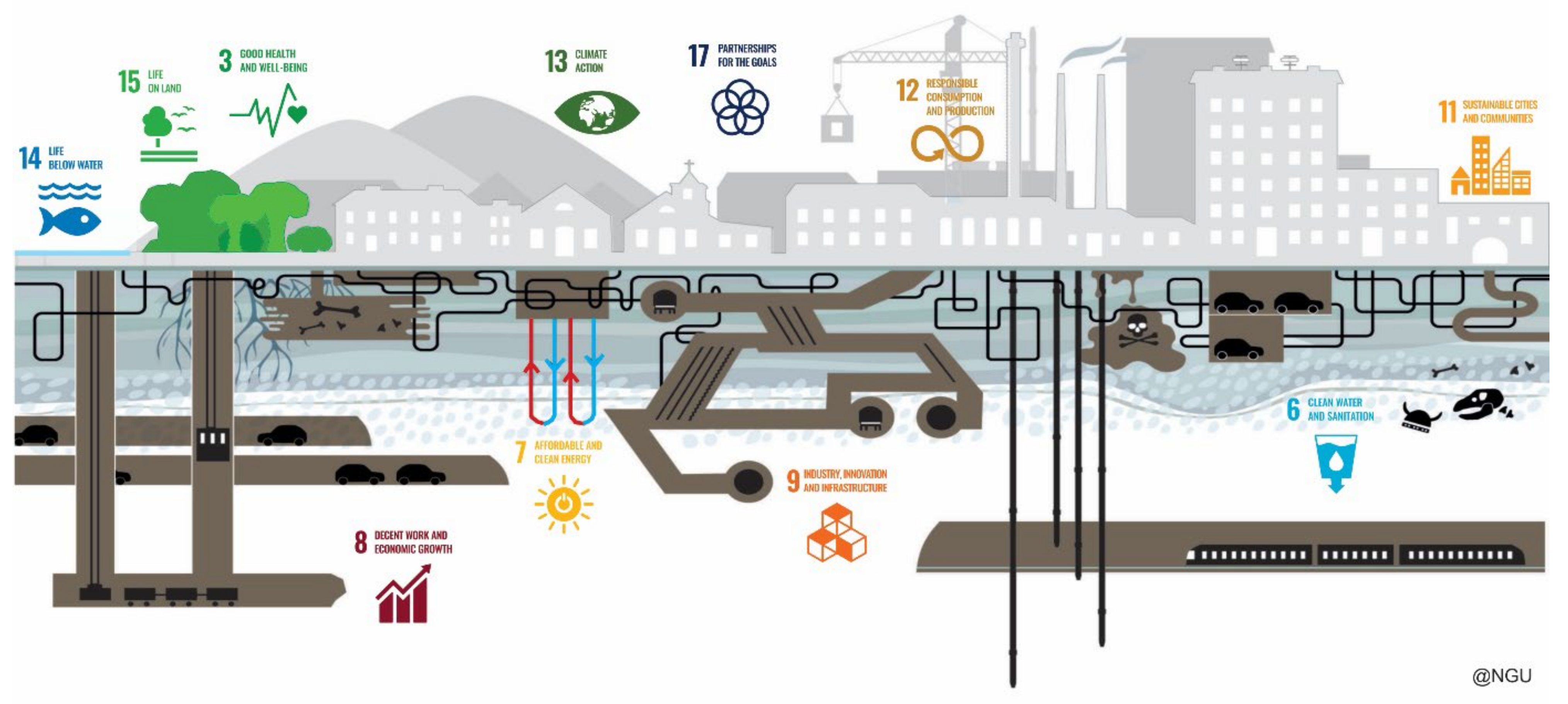
2.1. UN Sustainable Development Goal: 11 Sustainable Cities and Communities
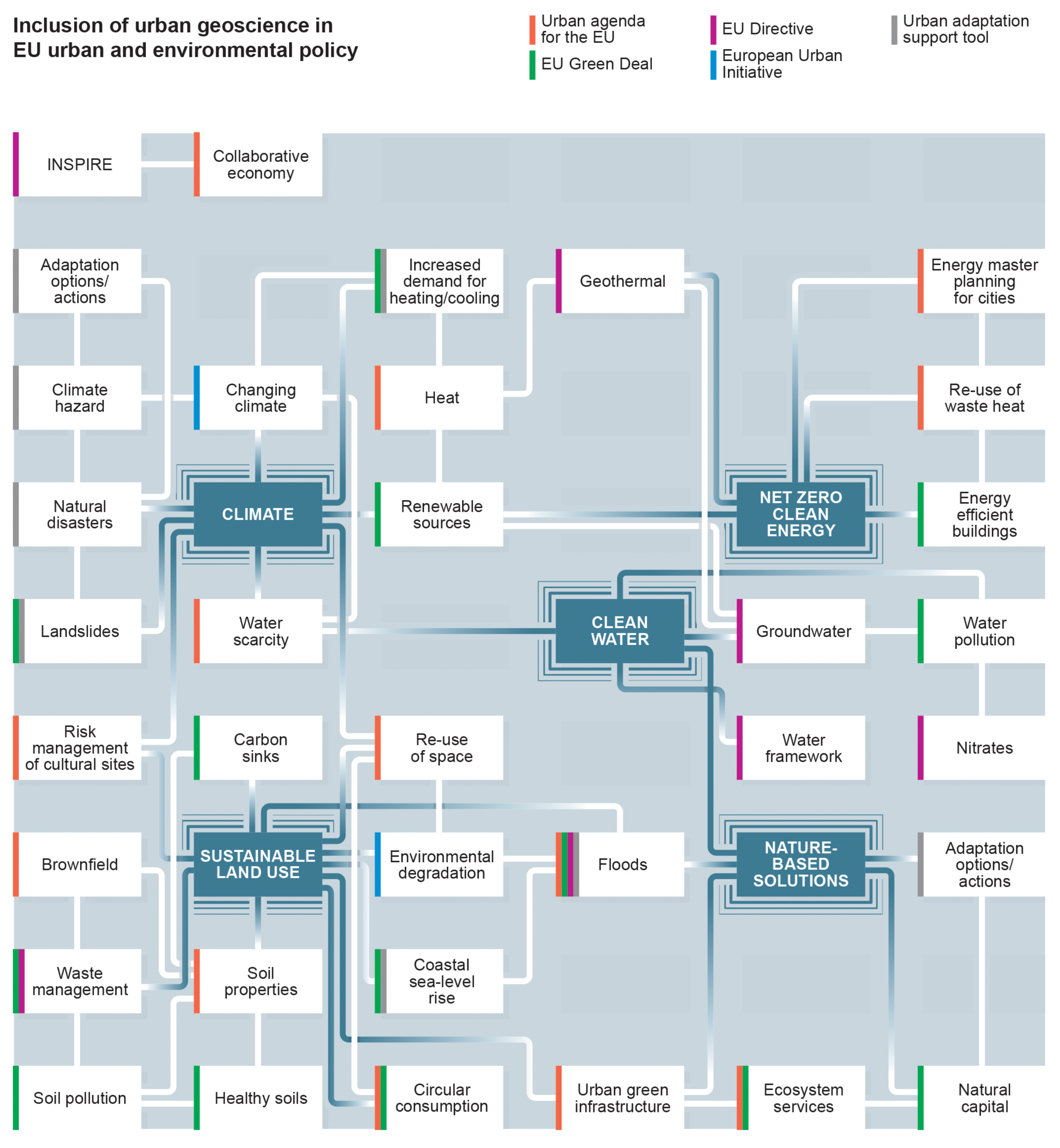
SDG 11 aims to make cities and human settlements inclusive, safe, resilient, and sustainable. With seven targets linked to eleven indicators and three means of implementation, the collective ambitions are as follows: to improve basic services and transport, upgrade informal (slum) settlements, develop inclusive and regional planning that acknowledges the links between city and rural and peri-urban areas, safeguard the environment and the cultural and natural heritage, improve disaster risk management, and improve health, especially air quality, with universal access to green space. The pivotal role of sustainable urbanisation (SDG 11) in delivering the other SDGs, such as Clean Water and Sanitation (SDG 6) and Industry, Innovation, and Infrastructure (SDG 9) is described by Misselwitz and Salcedo Villanueva [36], who highlight direct links and integration with 10 of the 17 other goals, including 30% of the targets and 39% of their indicators. Furthermore, Admiraal and Cornaro [37] note that better use of urban underground space could specifically help to deliver six of the seventeen SDGs. Figure 2 provides an illustrative representation of the urban system, highlighting how urban centres contribute to the delivery of 11 of the 17 SDGs. The subsurface and geological components of the urban system shown in Figure 2 (e.g., soils, water, mineral resources, green space, geothermal heat, buried infrastructure) are intrinsically linked to the delivery of these SDGs. One of the key issues in measuring and comparing progress against the SDG goals is consistency in the definition of urbanisation. In 2020, the UN Statistical Commission approved a definition, and this, combined with the European Commission-led Global Human Settlement Layer, now permits the harmonisation of indicators for cities and settlements and increases the use of interactive map data to analyse the rural–urban continuum.
Smith and Bricker [4] describe the importance of urban geoscience to help meet SDG 11’s targets, highlighting the role that geological knowledge and data play. It promotes an understanding of the subsurface and geological processes for disaster risk management, protecting communities from harm, and managing risk in development areas vulnerable to geohazards. For “Data systems and smart cities” (SDG targets 11 A and B), Smith and Bricker [4] note that mandating or incentivising subsurface data sharing in tandem with the development of digital data systems offers greater potential for holistic, evidence-based urban planning and improved governance [4].
SDG 11 also provides the overarching agenda for the UN Habitat’s National Urban Policy (UN Habitat III Conference in 2016) and the New Urban Agenda [38], which seek to offer national and local guidelines on the growth and development of cities through to 2036. The UN Habitat programme defined three key dimensions as accelerators for sustainable development and, in 2020, announced spatial sustainability as a fourth concept. Integrated water management (recharge, retention, storage, and re-use), renewable, affordable energy, and management of hazards (geological and hydrological) are integral to the New Urban Agenda and intrinsic to sustainable and resilient urban living. The subsurface geology sets the premise for all living things. As a result of COP15 [23], an agreement on global biodiversity mapping was initiated, giving national incentives to recognise geology as an important factor in preserving ecosystems.

2.2. EU Policies

A review of EU urban and environmental policies and strategies has been undertaken to assess the extent to which urban geoscience issues and opportunities are represented at a policy level. The review comprised a key-word search (search terms: Environment, Energy, Flooding, Geology, Geothermal, Groundwater, Hazard, Natural capital, Nature-based solutions, Soil, Subsidence, Subsurface, Sustainable drainage systems, Underground, Water) of the following policy and strategy documents: ‘Living well within the limits of our planet’ 7th General Union Environment Action Programme to 2020 [39]; the new Environment Action Plan to 2030 [12]; New EU Adaptation Strategy [40]; Thematic strategy on the sustainable use of natural resources [41]; European Framework for action on cultural heritage [42]. Further, a review of select EU urban and environmental initiatives (EU Green Deal [10]; Urban Agenda for the EU [11]; European Urban Initiative [43]; Urban Adaptation Support Tool [44]) was completed to capture the priority topics of relevance to urban geoscience.
There is no reference to the urban subsurface or underground environment in the EU policy and strategy documents, and no direct mention of the role of geology or the geosciences. However, there is occasional reference to specific components of the urban geological system, e.g., the use of geothermal energy is referred to in the Thematic Strategy on the Sustainable Use of Natural Resources [41], the impact of drought on groundwater systems is highlighted in the EU Adaptation Strategy [40], and the impact of ground subsidence is mentioned in the New Urban Agenda (Habitat III). Furthermore, there is a reference to flooding, natural disasters, and the management of soil systems across several of the policy and strategy documents. ‘Water’, ‘natural environment’, and ‘energy’ are commonly cited as over-arching topics of importance for urban areas (e.g., with reference to climate impacts, resource efficiency and affordability, and environmental enhancement), but the geological components of these topics are not explicitly identified. Figure 3 is used to summarise the review of ‘geosciences’ in EU urban and environmental policy; it provides a graphical representation of the priority topics contained within the EU policy and strategy documents that require consideration of the urban geological environment. These topics broadly coalesce around five key challenges: sustainable use of land; climate impacts and mitigation; transition to net zero energy; implementation of nature-based solutions; and clean water. Within these five themes are a significant number of topics that require geological considerations. The links between the geo-environmental themes and topics are provided in Figure 3. These provide a clear route for urban geologists to outline practical measures to address the broader ambitions embedded in EU policy, despite the fact that the urban subsurface environment is not explicitly referenced. Taking as an example the urban groundwater environment and the role of the urban hydrogeologist, groundwater systems—whilst often ‘out of sight and out of mind’—play a crucial role in the security of water resources, particularly under a changing climate. Groundwater systems sustain groundwater-dependent ecosystems, wetlands, rivers, and urban green spaces, they provide a thermal resource for ground source heating systems, and they are a crucial consideration for nature-based solutions with respect to flooding, sustainable drainage options, and control of urban heat island effects [45]. The influence of groundwater systems in the management of urban hazards, e.g., flooding, sea-level rise, landslides, volcanic hazards, ground subsidence, and land contamination, can also not be underestimated and should be considered by city planners as a crucial aspect in urban resilience assessment and strategy [8].

3. Responding to Current Urban Pressures

Aside from population growth, De Mulder [28], in their overview of urban geology in Europe, cites a number of urban pressures associated with the geological environment. Enquiry responses from 28 major Western European cities highlighted numerous ‘geo-problems’ in urban settings, primarily associated with anthropogenic change within the subsurface and hydrological hazards, and they reflected the emphasis at the time on engineering and ground constraints. Groundwater pollution, flooding from rivers, and subsidence were the primary causes of concern, where subsidence was due to either mining hazards, loading, or groundwater abstraction. Issues associated with erosional processes, landslides, and earthquakes were reported for approximately half of the responding cities. Saline soils and tsunamis were indicated as concerns, albeit to a lesser extent (≤10%). Though Central and Eastern European cities were not explicitly surveyed by De Mulder [28], the review considered geo-problems associated with a sub-set of Central and Eastern European countries and concluded that the urban geo-problems experienced were not dissimilar to those of Western Europe.
Thirty years on, we are in a position to revisit the urban geology context for Europe. A 2020 survey by EuroGeoSurveys of its 36 member countries revealed that 21 undertake urban geology mapping, 11 provide geoscience communication for urbanised areas, and 10 undertake studies with respect to urban management. Overall, urban geology projects provide income for 25 of the 34 Geological Survey Organisations, with urban geology making up more than 10% of the income for Greece, Italy, Lithuania, Luxembourg, Serbia, and Switzerland. The majority of Geological Survey Organisations (GSOs) undertake aligned geological research of direct relevance to urban environments, including hydrogeology (92%), geohazards (86%), industrial and construction materials (86%), geothermal energy (84%), heritage and conservation (73%), geotechnical data (73%), engineering geology (62%), and land-use management (51%), demonstrating strong capability and transferrable skills for urban geoscience.
Updated information on the current urban geological pressures has also been obtained via engagement with >40 urban geoscience experts from across 24 member countries of EuroGeoSurveys. Unsurprisingly, the pressures of geohazards, coastal hazards, and urban groundwater use still persist, though the risks and exposure associated with these pressures have increased as a result of ongoing urbanisation and climate change. The results are summarised in Table 1 and reveal a change in emphasis towards integrated urban science. This is a reflection, as anticipated by De Mulder [28], of increased public concern around environmental degradation but also a reflection of the need to tackle the current climate emergency [46,47,48] and deliver the Sustainable Development Goals (e.g., SDG 11). Decarbonisation, climate adaptation and nature-based solutions, resource optimisation, risk management, and the adoption of digital data workflows are the prominent urban geoscience priorities emphasised by geologists in Europe (e.g., [49]). As such, stronger associations between geoscience expertise and climate scientists, urban planners, utility service providers, the insurance sector, and geospatial analysts are warranted.

4. Meeting the Research Needs

A series of research priorities emerge for the urban geoscience community in response to current urban pressures and European policy objectives. A brief account of these priorities, grouped by urban pressure, is provided below and presented in Table 1. An overview of advances in digital data workflow and data-driven decision-making is considered separately in Section 5.

4.1. Strategic Research Priorities

Net-zero cities: The urban geoscientist can make a significant contribution to climate mitigation through the decarbonisation of the energy sector. This includes research and policy development for increased use of shallow and deep geothermal energy, and the installation of ground source heat and cooling systems and urban heat distribution networks to facilitate the re-use of waste heat. Another emerging geoscience research area is the use of water from abandoned mine workings (e.g., coal mines) for heating and cooling and the evaluation of this as an urban energy source [50]. Geoscientists assist in the monitoring of water and heat in the urban subsurface; geological property characterisation (e.g., thermal properties); 3D modelling of ground conditions to assess engineering geology constraints for the construction of energy systems; 4D modelling to evaluate geothermal resources and energy storage capacity, heat flow through the subsurface, and perturbations in the environment due to geothermal energy use, e.g., microbiological and geochemical changes. The use of shallow groundwater-based geothermal energy was specifically referred to in the EU Thematic Strategy on the Sustainable Use of Natural Resources [41]; it has been demonstrated as a viable clean energy source in many European countries, including the Netherlands [51] and Norway [52], and a European framework to manage and govern the implementation of shallow geothermal energy systems has been established [53].
Climate adaptation and nature-based solutions: Urban geoscientists are accustomed to providing evidence on geological hazards and the impacts of climate change, e.g., impacts on the availability of water resources, environmental risks to infrastructure, or coastal erosion. However, there is a change in emphasis within the EU strategy towards climate adaptation and solution-focused research, e.g., via the EU Adaptation Strategy [40] and, at the local level, the development of city authority Climate Action Strategies and adoption of the EU Urban Adaption Support Tool [44]. Delivering benefits through the implementation of nature-based solutions, such as sustainable drainage systems (SuDS), urban green spaces, or urban wetlands, is central to these strategies. Urban planning is no longer just a consideration of population growth and urban expansion but must also account for a range of future scenarios that allow for climate change predictions and the associated uncertainty. Geologists must put forward a series of adaptation options that account for those different future urban scenarios; geologists must be able to define and communicate the uncertainty to urban practitioners and assist in reducing that uncertainty. With an emphasis on sustainability, security, and resilience of urban places and communities, there is a need to consider the interaction between the natural and built environment [54], understand the cascading effects of geological hazards [55,56], and evaluate the social and political implications of climate adaptation measures. This means, for example, defining the climatic and human-induced impacts on the urban water environment [9,57], including changed water management, e.g., the reallocation of water abstraction from city centres or repair of fractured drainage systems, both of which can cause groundwater levels to rise and cause damage to urban infrastructure [58] and call for climate adaptation, including the use of nature-based solutions and assessing the multiple societal benefits or natural capital of geological systems [59].
Resource optimisation: The increased pressure on urban subsurface space and natural resources, as a result of both higher metabolic urban demand and climate change, is the dominant influence on research in support of resource optimisation. Mitigating the impacts on existing resources, such as managing the impacts of drought, floods, and pollution, on the quantity and quality of groundwater resources [60] and soil systems is a critical area of research, alongside the sustainable exploitation of emerging resources, such as geothermal energy and energy storage potential. The assessment of the demand and supply of construction materials for urban development via material resource flow analysis and the evaluation of the subsurface re-use potential of geological and non-natural materials in line with EU strategies for circular consumption are topics of growing importance (e.g., [61]). The on-site management, temporary storage, treatment, and re-use of construction waste (e.g., re-use of aggregate arisings) are additional challenges for large urban construction projects with space constraints and strict sustainability targets. Together, these issues highlight the potential for competing and interacting geological demands being placed on urban subsurface space and the need for coordinated subsurface urban planning and plans for the best (re)use of space.
Geohazards and risk management: Geospatial assessment of geohazards and hydro-hazards and associated hazard management were some of the original drivers for the initiation of urban geology research. Efforts initially focused on the assessment of geological hazards for planning and construction, the creation of hazard susceptibility maps, and the communication of hazards to urban stakeholders. Over time, the emphasis has shifted, firstly to include assessments of multi-hazard environments and cascading hazards (e.g., landslides that induce flooding, etc.), and secondly to quantify the risk associated with geohazards working in partnership with insurers (e.g., [62]) and built environment specialists to define the probability and scale of impact on communities and the built environment. The use of remote sensing technologies, such as InSAR (interferometric synthetic aperture radar), which maps ground motion using radar images, and the Copernicus Land Monitoring Service, which provides geospatial information on land cover changes, or a pan-European ground motion service, can assist this research [63]. One such example is the European PAN-GEO project [64], which combines detailed analyses of local geological data with InSAR measurements of ground movement to provide free geohazard maps for more than 50 cities in Europe. In addition, we have witnessed a broadening of geohazard research to consider anthropogenic impacts on the urban landscape, such as hazards arising from anthropogenic materials deposited during multiple phases of urban development.

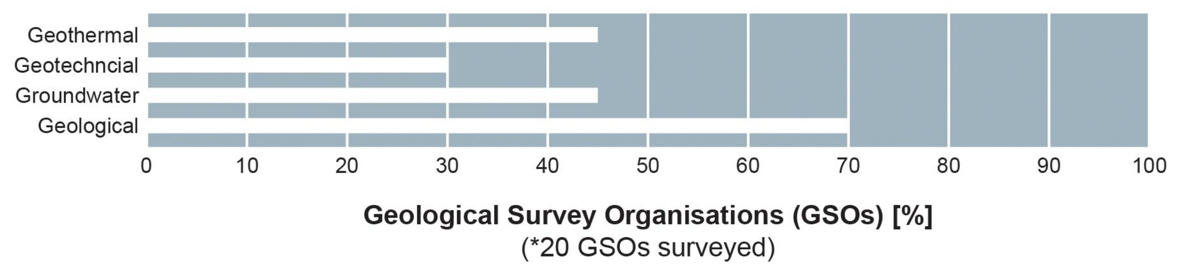
4.2. Urban Geology Expertise in Europe

In 2013, an EU Sub-Urban Action was launched, funded by the EU Cooperation in Science and Technology (COST). The ‘Sub-Urban’ Action TU1206 was successful in linking 23 city authorities across Europe with their respective geological surveys to draw expert perspectives on urban challenges such as groundwater management, 3D geological modelling, and subsurface planning [17]. Building on the legacy of the Sub-Urban Action (TU1206, 2013–2017), an Urban Geology Expert Group (UGEG) was formed in 2019 under EuroGeoSurveys. The network comprises more than 60 experts from 24 European countries. The aim of the group is to support Europe’s Urban Agenda and urban policies to fulfil the requirements of European Commission (EC) Directives and the UN Sustainable Development Goals. In particular, it provides a focal point for the delivery of high-quality scientific information and expertise relevant to the needs of the EU’s urban decision-makers and European institutions in the areas of sustainable urban development, urban resilience, smart cities, and safe construction. Three science priorities are being taken forward that underpin the ‘safety, security and wellbeing’ and ‘Digital Twin’ goals of the EuroGeoSurveys Strategic Research and Innovation Agenda [29]:
  • Geo-city information modelling (Geo-CIM): Based on the principles of building information modelling (BIM), Geo-CIM is a geology-based digital workflow to support urban planning. Where traditionally, geoscience data are used to develop geological models, Geo-CIM seeks to transform the way geoscience data are used within urban systems and models to enable geology-informed decision-making by urban experts, which is evidence-based and digitally driven. It aims to produce user-oriented geospatial data that will improve efficiency in land-use planning and the construction of a life cycle by deriving better value from geoscience data and information. The Geo-CIM digital workflow covers the adoption of software-agnostic digital data standards and common vocabularies; FAIR principals, (where data are findable, accessible, interoperable, and reusable) to high-resolution data from multiple sources; the application of 3D geological modelling techniques with relevant attribution of geological properties (e.g., hydrogeological, engineering, and thermal properties); the development of dynamic models, including machine learning-based models [65] used for prediction and forecasting with the potential for real-time updates; and, perhaps most importantly, the integration of the geoscience data models within the urban decision-making process, either through the direct use of the geoscience data, the linking of geoscience and (above-ground) urban models, or the translation of the geoscience data within urban decision-support tools. Geo-CIM might be as complex as a city digital twin, which includes dynamic elements of the urban subsurface environment, or as simple as a geology-based map embedded within a local authority geographic information system (GIS), according to the EU INSPIRE Directive. Regardless, the solution is driven by the urban challenge and co-designed with the urban user. A pan-European goal is the European Geological Data Infrastructure (EGDI) [66], providing standardised geological data across borders, driven by EuroGeoSurveys [67].
  • Geo-environmental pressures in urbanised catchments: Often, urban areas are treated in isolation without recognition of the interaction with the wider catchment. This lack of rural–urban connectivity is highlighted (e.g., by the EEA) as a barrier to spatial planning and economic growth. A catchment-based or systems-based approach that embraces the wider geo-environmental setting and evaluates the connections between the physical–social and environmental urban parameters is needed to fully understand the impacts of climate change, demographic change, resource and waste flows, and land-use change. It recognises the internal and external anthropogenic and environmental agents of change in urban landscapes. These methods take into account the transient nature of environmental systems and the different spatial and temporal scales on which geo-environmental factors operate. Using this style of approach, it is possible to assess the extent to which the ‘catchment’ can support the urban natural resource needs without causing environmental degradation; to mitigate the multiple and interacting geo-environmental pressures impacting communities; to identify opportunities for nature-based solutions to underpin (urban) resilience and sustainability. In this context, the ongoing Urban Geo-Climate Footprint (UGF) project [68] was born to provide a geological classification of cities and quantify geological factors affecting the urban catchment. The Urban Geo-Climate Footprint provides a score index, which represents the geological complexity of the urban catchment [68]. The UGF has been applied to 40 cities within Europe to classify them by urban geology typology and encourage city peer-to-peer learning.
  • Geoscience communication: The solutions to our urban challenges require interdisciplinary collaboration; the geosciences are no exception. Often, it is not a lack of geoscience data or research that prevents solutions to our urban challenges but a failure in the accessibility and application of data and information and an experience gap in the interpretation and implementation of scientific results. The modern urban geoscientist must act both as a scientist and a knowledge broker to bridge the gap between subsurface experts and city practitioners. The challenge of communication is not simply one of raising awareness of urban geoscience; it is about meaningful, early engagement with co-designed approaches; it is about demonstrating the value of geoscience information and the tangible benefits that can be delivered when it is embedded into policy, industry practice, land-use planning, and urban design.

5. Data-Driven Decision Making

Perhaps the greatest change in the 30 years since the paper by De Mulder [28] is the evolution of digital data and modelling systems, including the standardisation of digital data for use across disciplines and borders. Of the 37-member geological survey organisations of EuroGeoSurveys, 81% have a data management remit, 92% produce spatial geological information, and 73% have a specific focus on geotechnical data. The increased emphasis on digital data workflows in geosciences is arguably due to the maturation of geospatial technologies. However, the introduction of the EU INSPIRE Directive in 2007, which aimed to enhance the sharing of environmental spatial information among public sector organisations in Europe, and the recognition of the value of open digital data for the geoscience community [69] are also strong influences. In the Netherlands, new legislation (2015) mandated that subsurface data acquired with public funds (e.g., for national infrastructure) must be submitted to a central ‘key register’ for the subsurface ‘Basisregistratie Ondergrond’ (BRO), and all public bodies must consult the ‘key register’ when making decisions that impact the subsurface [34]. Access to the ‘key register’, particularly at the early stages of construction projects, is anticipated to deliver a reduction in subsurface-related failures of 2–5%. The projected net present value of the ‘key register’ was estimated to be about EUR 80 million in 2019, rising to EUR 130 million from 2028 onwards [33]. Similarly, the National Database for Ground Surveys in Norway (NADAG), established in 2014, was, in 2015, estimated to have a yearly societal value of EUR 1,6 million [70]. With new legislation [35] requiring all ground drilling to be reported, the value of the national database will increase exponentially. Since 1984, a national law (L. 464/1984) in Italy obliges everyone to submit data from any borehole deeper than 30 m to the Geological Survey of Italy (ISPRA). Registers of subsurface data, comprising borehole records and records from ground investigations, e.g., groundwater levels and geotechnical data, are common within European GSOs. Of the 20 GSOs responding to the urban geology survey (2020), 17 have borehole databases and 14 have groundwater databases. In all instances, the data are available to users via an online viewer and, in some instances, by direct download. In the UK, for example, approximately 50,000 onshore borehole records provided by the National Geoscience Data Centre are downloaded each month [69]. In some countries (e.g., Austria), borehole databases are maintained at the city scale and are owned by the city municipality.
The application of INSPIRE and the FAIR principles has been fundamental to demonstrating the value of geological data, particularly third-party ground investigation data for urban applications, and was a central theme of the EU (COST) ‘Sub-Urban’ Action (TU1206, 2013–2017), which evaluated subsurface data acquisition and management and subsurface modelling and visualisation. Working with industries, regulators, and local governments, the ‘Sub-Urban’ Action assessed the digital capability and institutional readiness for the uptake of urban geoscience information within city municipalities across 17 European countries and explored the policy and legal basis for the sharing and re-use of data, with the ultimate aim of unlocking the value of the subsurface data. Approximately two-thirds of the countries surveyed have no legal framework for the management of ground investigation data arising from construction projects. Without a legal mandate for the submission of subsurface data, GSOs are reliant on voluntary donations by the data owners, in this case primarily a mix of private and public-sector organisations, with mixed success. In the UK, it is estimated that 80% of historic ground investigation data are currently missing from the national geoscience data centre archives. Based on an annual investment of GBP 230 M in ground investigation, this equates to a loss of data and knowledge to the UK economy of an estimated GBP 184 m/y [71]. However, through initiatives like ‘Sub-Urban’, European GSOs have been successful in negotiating standard contractual clauses with public sector organisations (e.g., environment regulators and transport departments) for the submission of ground investigation arising from publicly funded works and the promotion of standard digital data formats (e.g., AGS 4 Data Format 2020 [72]).
Despite the challenges, digital transformation has brought significant advantages for towns and cities that require data-driven decision-making for local development plans and subsurface master planning. Geospatial datasets are an ideal information source for planners as they can be used in (open-source) GIS software and they can easily store and display multiple quantitative and qualitative attributes, providing users with both targeted data and supporting information. The provision of geological datasets applicable at the urban scale (1:50,000 or larger) is no exception. A survey (conducted in 2020) of urban geoscientists from 20 countries within EuroGeoSurveys shows the positive steps that geological surveys have made to make geospatial data available to urban decision makers (Figure 4). All GSOs provide a bedrock geology map suitable for application at the urban scale (1:50,000 or larger), 16 provide quaternary geology or superficial deposits maps, and 19 offer a hydrogeology map. Fifteen countries offer 10 or more urban-scale geospatial datasets (e.g., maps on engineering geology, subsidence hazards, mining-affected areas, geoheritage sites), with a limited number (<20%) offering bespoke urban planning packs and data tools (Figure 4). The discrepancy, highlighted by de Mulder [28], between geological problems identified by city planners and the availability of geoscientific information necessary to predict and mitigate geological and anthropogenic hazards is not evident in this recent review, where we observe good availability of geohazard data. Rather, there is now an urgency for geospatial data to address current science priorities relating to decarbonisation and climate adaption, such as identifying available geothermal energy resources, assessing the suitability of the ground for sustainable drainage systems [73], assessing the re-use potential of geological waste materials, and evaluating soil properties for carbon storage and climate-resilient planting.
The need to identify urban geological opportunities and adaptation options is partly addressed through the generation of 3D geological models and 3D–4D urban thematic models (e.g., [74]). Around 70% of GSOs in Europe develop 3D urban geological models, which are commonly used to provide early identification of ground conditions to allow for targeted design and construction methods and to help reduce project risk, delays, and costs [33]. The 3D models have the added benefit of providing a shared digital conceptual ground model to aid subsurface visualisation and maximise knowledge transfer across disciplines and with communities. As such, 3D models are often used as the geological basis for onward environmental process modelling, particularly for groundwater investigations and for the evaluation of geothermal energy and ground heat (e.g., [57]). In Europe, approximately 45% of GSOs develop 3D models for groundwater and geothermal applications, and 30% generate 3D geotechnical models (Figure 5). The application of 3D models for specific urban policy areas for a selection of European cities is provided in Table 2; currently, 3D models are most commonly being used for soil pollution and management, water management, and hazard management. There is potential to use 3D models for climate adaptation, urban development and planning, sustainable energy, and cultural assessments, but this potential is yet to be fully realised. Dynamic monitoring of urban environments with (near) real-time modelling and model integration is a current focus area for the urban geoscience community through the emergence of digital twin approaches, building information modelling (BIM), smart-sensor technologies, and remote sensing satellite applications. The integration of geological data models with climate data models, built environment models, and socio-economic models is particularly encouraged [74]. Recent examples from Europe include a 3D above- and below-surface Geo-CIM model of the city of Liberec, Czech Republic [75]; the financial case for SuDS, e.g., Bryggen (Wharf) in Bergen, Norway [76]; remediation costs for brownfields [77]; and property subsidence assessments. Regardless of the model complexity—which varies across Europe—3D models need to be regularly updated. This is due not only to the fact that the urban environment and subsurface are constantly changing, with available data often acquired before building activities or other human interventions took place [18,78] but also to the need to keep pace with increasing data, technology, population, and climate change. Schokker et al. [57] point out that, currently, there are no general workflows available that enable rapid updates to 3D geology models, though the adoption of machine learning techniques within the geological community will likely see rapid developments in this regard.

6. Discussion

The concept of urban metabolism is helpful in describing the functions and resource requirements of urban centres. Usefully, it places the urban centre in the context of its wider catchment and acknowledges the environmental dependencies and impacts. However, the underlying assumption that the environment and its resources are commodities is tempered against the ambitious sustainability principles enshrined in international and EU policy to ‘live well within the limits of our planet’, to live in harmony with the environment through environment-sensitive urban design, to embrace a circular economy, and to apply nature-based solutions for climate adaptation and urban resilience. In our review of European urban and environmental policy, we find that climate impact assessment and adaptation, preservation of the water environment, clean energy consumption, adoption of nature-based solutions, and sustainable use of land are key policy priorities in which urban geoscience plays a clear role (Figure 3). The urban geoscience discipline is successfully evolving to deliver integrated urban science in response to these policy aims, with strong alignment between the policy themes, urban pressures, and research priorities (Table 1). The review of urban geoscience research priorities shows that the discipline is broadening to embrace wider geo-environmental specialisms, including geothermal expertise, geo-data and informatics, geoheritage, and science policy. Further, there is enhanced collaboration between urban geoscientists and aligned sectors, such as climate scientists, urban planners, utility service providers, and the insurance sector. While <30% of the European Geological Survey Organisations undertake urban management and geo-communication projects, the capacity for integrated urban research programmes within and external to the GSOs is high given the existing uptake (>70%) of geological research and transferrable skills directly aligned to urban priorities, including hydrogeology, geohazards, construction materials, geothermal energy, geoheritage and geotechnics. The information gap, highlighted by de Mulder [28], between geological hazards identified by city planners and the availability of geoscientific information to address them is no longer evident. We observe excellent availability of geological map data, borehole databases, geohazards maps, and 3D geological modelling expertise. Though, in many cases in Europe (e.g., the Netherlands, Norway, and Poland), it has been necessary to introduce new legislative frameworks to mandate the submission of subsurface data to relevant organisations to support better subsurface management. Further expansion of legislative, policy, and contractual frameworks to enhance the capture and (re)sharing of subsurface data is recommended. Whilst digital transformation around geo-data systems has been very high over the last 30 years, the transition of urban geoscience to embrace wider themes and specialisms means there is still a need for data, models, and decision-support tools to support urban land-use planning that are targeted to climate adaptation, risk reduction, and energy transition. Innovation around the integration of geological data systems with climate data models, built environment models, and socio-economic models is also expected. In combination, these expanded approaches to data services and decision-support tools would further align urban geoscience capabilities with Europe’s policy agenda.
In addressing integrated urban science priorities, there will always be a delicate balance between capturing the complexity of the geological system, including all its uncertainties, and delivering a solution that meets the needs of the urban user community; a solution that is digitally accessible and targeted to the policy drivers. The creation of bespoke data packages for urban planners in some countries offers some progress towards this, though embedding geological data directly within urban planning digital systems is preferable. The geoscientist is accustomed to working at the regional–national scale, developing standard methodologies, and defining over-arching best practice guidance for thematic topics. This approach does not necessarily translate for the more localised, highly variable urban setting, which requires a higher data resolution and rationalisation of a number of shallow subsurface land uses. Working at the urban scale, the geoscientist needs to adopt flexible approaches that allow methods and guidance to be adjusted for the specific character of the urban centre, i.e., a 3D modelling approach that works in one city is not necessarily appropriate for another. Rather than national-scale-applied geology data products, we should instead be developing national-scale maps with nested urban-scale mapping. The use of geological domains and urban typologies, such as those defined in the Urban Geo-Footprint tool [68] or in the groundwater–city typologies proposed by La Vigna [8], goes some way to addressing this challenge and strengthens the possibility of city-to-city exchanges of best practices and solutions. Despite adopting localised approaches for urban challenges, the importance of national-scale foundational data management should not be forgotten, e.g., data standards, data security, and the use of authoritative datasets like the ones stored in (national) key registries and in the European Geological Data Infrastructure (EGDI) at a pan-European level [66,69]. Fundamental to providing useful information to resolve urban questions is the integration of subsurface and above-ground information and models, including the presence of man-made ground and man-made objects, such as utilities, tunnels, sheet piling, and subterranean archaeological heritage (e.g., [57]).
The role of the urban geoscientist becomes critical in adopting modern working practices; a sentiment echoed by Earle and Goh [78] in their review of the Built Environment Research Landscape, which calls for ‘a new cadre of academics with the interest and ability to work across disciplines’. The urban geoscientist must be both a scientist and a knowledge broker, promoting interdisciplinary working and effectively communicating the value of geological information for urban challenges. The science must be problem-orientated and solution-focused, applied at the appropriate city-to-catchment scale. The urban geoscientist is an advocate for integrated surface–subsurface approaches, ensuring that the geological system is assessed in conjunction with the natural–built–social systems operating at the surface. The urban geoscience community already has a diverse representation of ‘hard’ and ‘soft’ geological skills, but in seeking to connect with other experts from a diverse range of backgrounds, urban geoscience offers a route to improve diversity, equity, and inclusion within the geological community. Urban environments are more accessible and provide context for geological science that people can readily observe and associate with. Moreover, the diverse range of urban challenges and actors provides multiple routes for the importance of geology to be disseminated to different communities.
Further challenges remain for the urban geoscience community. The predominant one being that no one type of organisation has a remit for the management of the urban subsurface. There is a diverse range of stakeholders and organisations that operate within or have responsibility for elements of the subsurface environment. These ‘actors’ have different remits that cover government, industry, and public interest. Some operate at the urban scale, others at the catchment or national scale. Developing a shared vision for urban subsurface management when there is a lack of coherence across these interests is difficult but is beginning to be addressed by initiatives within Europe (e.g., UK Government Office for Science Future of the Subsurface Foresight Project, [31]). To this end, the formation of a cross-departmental government agency for subsurface management that operates as part of the wider urban planning system may be recommended.
Demonstrating the value of urban geoscience for different urban challenges is important for the onboarding of influential stakeholders, less so in terms of direct income from urban geoscience data and research but in terms of, e.g., the value of geo-data for urban development, demonstrating the multiple benefits of nature-based solutions, risk reduction in hazardous urban environments, even in demonstrating knowledge-creation in aligned non-geological organisations or improved diversity within geological communities. Impact analysis covering the breadth of urban geoscience reach and knowledge and its contribution to a more sustainable urban future is needed.

Author Contributions

Writing of the manuscript: S.B., M.S., G.V. and J.S. Review of urban subsurface planning and policy: S.B., M.S. and G.V. Analysis of geological survey data and model capability: J.J., J.S. and G.R. Analysis of urban pressures and urban geology research priorities: S.B., M.S., G.V., J.S., J.J., P.V.d.K., F.L.V., S.O., G.R., M.S. and J.S. All authors have read and agreed to the published version of the manuscript.

Funding

This research received no external funding. This research was funded by in-kind contributions of the European geological surveys affiliated to the authors as part of their respective commitments to EuroGeoSurveys.

Institutional Review Board Statement

Not applicable.

Informed Consent Statement

Not applicable.

Data Availability Statement

Data presented in this study are available on request from the corresponding author (S. Bricker; [email protected]). Restrictions may apply to the availability of data obtained from EuroGeoSurveys, these are available from the corresponding author subject to permission of EuroGeoSurvey. Data presented in Figure 1 were derived from the following resources available in the public domain: https://www.centreforcities.org/ accessed on 1 December 2023).

Acknowledgments

This study was carried out by EuroGeoSurvey’s (EGS’s) Urban Geology Expert Group with support from the British Geological Survey’s Urban Geoscience research programme. Support from EuroGeoSurvey member geological survey organisations is gratefully acknowledged. The authors thank Craig Woodward for the provision of the figure illustrations for the paper and Julie Hollis (EGS Secretary General) for her review of the paper. S. Bricker and M. Smith publish with the permission of the Executive Director of the British Geological Survey.

Conflicts of Interest

The authors declare no conflicts of interest.

References

  1. International Organization for Migration (IOM). World Migration Report 2015. Migrants and Cities: New Partnerships to MANAGE Mobility; International Organization for Migration: Geneva, Switzerland, 2015; Available online: https://publications.iom.int/books/world-migration-report-2015-migrants-and-cities-new-partnerships-manage-mobility (accessed on 1 May 2023)ISBN 978-92-9068-709-2.
  2. UNDP. United Nations Population Division. World Urbanization Prospects: 2018 Revision. ID: SP.URB.TOTL.IN.ZS. 2018. Available online: https://data.worldbank.org/indicator/SP.URB.TOTL.IN.ZS?locations=EU (accessed on 30 June 2023).
  3. Bessis, H. Competing with the Continent, How UK Cities Compare with Their European Counterparts. Centre for Cities, London. 2016. Available online: https://www.centreforcities.org/wp-content/uploads/2016/09/16-09-21-Competing-with-the-continent.pdf (accessed on 1 December 2023).
  4. Bricker. SDG 11: Sustainable Cities and Communities. In Geosciences and the Sustainable Development Goals, Sustainable Development Goals Series; Gill, J.C.; Smith, M. (Eds.) Springer: Cham, Switzerland, 2021; pp. 259–282. [Google Scholar] [CrossRef]
  5. John, B.; Keeler, L.W.; Wiek, A.; Lang, D.J. How Much Sustainability Substance Is in Urban Visions?—An Analysis of Visioning Projects in Urban Planning. Cities 48 (November), Urban Europe. 2015, pp. 86–98. Available online: https://www.sciencedirect.com/science/article/abs/pii/S0264275115000797?via%3Dihub (accessed on 1 February 2022).
  6. UN-WWAP (United Nations World Water Assessment Programme). The United Nations World Water Development Report. 2015: Water for a Sustainable World. UNESCO, Paris. 2015. Available online: https://www.unesco-ihe.org/sites/default/files/wwdr_2015.pdf (accessed on 30 June 2023).
  7. United Nations. The United Nations World Water Development Report 2023: Partnerships and Cooperation for Water; UNESCO: Paris, France, 2023. [Google Scholar]
  8. La Vigna, F. Review: Urban groundwater issues and resource management, and their roles in the resilience of cities. Hydrogeol. J. 2022, 30, 1657–1683. [Google Scholar] [CrossRef]
  9. Gogu, R. Urban Hydrogeology Studies. Water 2022, 14, 1819. [Google Scholar] [CrossRef]
  10. European Commission. The European Green Deal. 2019. Available online: https://commission.europa.eu/strategy-and-policy/priorities-2019-2024/european-green-deal_en (accessed on 15 June 2023).
  11. European Commission. Urban Agenda for the EU. 2016. Available online: https://futurium.ec.europa.eu/en/urban-agenda (accessed on 30 June 2023).
  12. European Commission. Decision (EU) 2022/591 of the European Parliament and of the Council of 6 April 2022 on a General Union Environment Action Programme to 2030. 2022. Available online: https://eur-lex.europa.eu/legal-content/EN/TXT/?uri=CELEX:32022D0591 (accessed on 15 June 2023).
  13. Price, S.J.; Ford, J.R.; Campbell, S.D.G.; Jefferson, I. Urban Futures: The sustainable management of the ground beneath cities. Geol. Soc. Lond. Spec. Publ. 2016, 27, 19–33. [Google Scholar] [CrossRef]
  14. Gill, J.; Smith, M. Geoscience and the Sustainable Development Goals; Springer Nature: Berlin/Heidelberg, Germany, 2021; ISBN 978-3-030-38815-7. [Google Scholar] [CrossRef]
  15. Volchko, Y.; Norrman, J.; Ericsson, L.O.; Nilsson, K.L.; Markstedt, A.; Öberg, M.; Mossmark, F.; Bobylev, N.; Tengborg, P. Subsurface planning: Towards a common understanding of the subsurface as a multifunctional resource. Land Use Policy 2020, 90, 104316. [Google Scholar] [CrossRef]
  16. Royse, K. The role of geological data in the SMART city agenda. GIS Prof. 2017, 74, 25–27. Available online: https://www.gim-international.com/content/article/the-role-of-geological-data-in-the-smart-city-agenda (accessed on 22 January 2024).
  17. Campbell, D.; de Beer, J.; Mielby, S.; van Campenhout, I.; van der Meulen, M.; Eriksson, I.; Venvik Ganerød, G.; Lawrence, D.; Bacic, M.; Donald, A.; et al. Transforming the Relationships Between Geoscientists and Urban Decision-Makers: European Cost Sub-Urban Action (TU1206). Procedia Eng. 2017, 209, 4. [Google Scholar] [CrossRef]
  18. Bobylev, N. Underground space as an urban indicator: Measuring use of subsurface. Tunn. Undergr. Space Technol. 2016, 55, 40–51. [Google Scholar] [CrossRef]
  19. Ikävalko, O.; Satola, I.; Hoivanen, R. Helsinki. COST TU1206 Sub-Urban Report TU1206-WG1-007. 2016. Available online: https://static1.squarespace.com/static/542bc753e4b0a87901dd6258/t/5707847d37013bb703023e29/1460110490550/TU1206-WG1-007+Helsinki+City+Case+Study.pdf (accessed on 1 May 2023).
  20. McGill, J. Growing Importance of Urban Geology; Circular 487. USGS Numbered Series; US Geological Survey: Reston, VA, USA, 1964. [Google Scholar] [CrossRef]
  21. De Mulder, E.F.J. Preparation and application of thematic engineering and environmental geology maps in the Netherlands. Eng. Geol. 1990, 29, 279–290. [Google Scholar] [CrossRef]
  22. McCall, G. (Ed.) Urban Geoscience (No. 20); CRC Press: Boca Raton, FL, USA, 1996. [Google Scholar]
  23. COP15, UN Biodiversity Conference, Montreal, Canada December 2022. Available online: https://www.unep.org/un-biodiversity-conference-cop-15 (accessed on 1 December 2023).
  24. Sherlock, R.L. Man as a Geological Agent—An Account of His Action on Inanimate Nature; H.F. & G. Witherby: London, UK, 1922. [Google Scholar]
  25. Wolman, A. The Metabolism of Cities. Sci. Am. 1965, 213, 179–190. [Google Scholar] [CrossRef]
  26. Kooijman, E.D.; McQuaid, S.; Rhodes, M.L.; Collier, M.J.; Pilla, F. Innovating with Nature: From Nature-Based Solutions to Nature-Based Enterprises. Sustainability 2021, 13, 1263. [Google Scholar] [CrossRef]
  27. Van der Meulen, M.; Campbell, S.D.; Lawrence, D.; Lois Gonzalez, R.; van Campenhout, I. Out of Sight Out of MIind? Considering the Subsurface in Urban Planning—State of the Art. In TU1206 COST Sub-Urban WG1 Report; TU1206-WG1.0-001. 2016. Available online: https://static1.squarespace.com/static/542bc753e4b0a87901dd6258/t/570f706201dbae9b1f7af3bf/1460629696046/TU1206-WG1-001+Summary+report+Out+of+sight+out+of+mind.pdf (accessed on 1 February 2024).
  28. De Mulder, E.F.J. Urban Geology in Europe: An overview. Quat. Int. 1993, 20, 5–11. [Google Scholar] [CrossRef]
  29. EuroGeoSurveys (EGS). Strategic Research and Innovation Agenda, Version January 2021. 2021. Available online: https://eurogeosurveys.org/strategic-research-innovation-agenda/ (accessed on 12 August 2023).
  30. Oslo Municipality. Planbeskrivelse: Kommuneplanens Areaødel. Oslo Mot 2040. “Plan Description: The Area Part of the Municipal Plan—Oslo towards 2040”. 2023. Available online: https://www.oslo.kommune.no/politikk/kommuneplan/kommuneplanens-arealdel/#gref (accessed on 1 December 2023).
  31. Government Office for Science. Future of the Subsurface Foresight Project, Initial Findings. 2023. Available online: https://www.gov.uk/government/publications/future-of-the-subsurface (accessed on 10 November 2023).
  32. Chapman, T. Geotechnical risks and their context for the whole project. In ICE Manual of Geotechnical Engineering: Volume I; Institute of Civil Engineers (ICE): London, UK, 2012; pp. 59–73. Available online: https://www.icevirtuallibrary.com/doi/epdf/10.1680/moge.57074.0059 (accessed on 30 September 2023).
  33. Gates, J.; Dabson, O.J.N.; Fitzgerald, R.J.; Free, M.; Gilson, B.; Manning, J.; Hosker, R.; Gakis, A.; Cabrero, P.; Entwisle, D.; et al. The Economic Case for Establishing Subsurface Ground Conditions and the Use of Geological Models. In Applied Multidimensional Geological Modeling; Turner, K.A., Kessler, H., van der Meulen, M.J., Eds.; Wiley: Hoboken, NJ, USA, 2021. [Google Scholar] [CrossRef]
  34. Ministerie van Binnenlandse Zaken en Koninkrijksrelaties. National Key Registry of the Subsurface. 2023. Available online: https://basisregistratieondergrond.nl/english/ (accessed on 12 May 2023).
  35. Norwegian Government 2023. New Legislation for Subsurface Surveys/Drilling. Foreslår Plikt til å Melde inn Grunnundersøkingar og Naturskadeutgreiingar-Regjeringen.no. Available online: https://www.regjeringen.no/no/aktuelt/foreslar-plikt-til-a-melde-inn-grunnundersokingar-og-naturskadeutgreiingar/id2967090/ (accessed on 10 November 2023).
  36. Misselwitz, P.; Salcedo Villanueva, J. The urban dimension of the SDGs: Implications for the New Urban Agenda. In Sustainable Development Goals and Habitat III: Opportunities for a Successful New Urban Agenda; Cities Alliance: Brussels, Belgium, 2015; pp. 13–22. [Google Scholar]
  37. Admiraal, H.; Cornaro, A. Why underground space should be included in urban planning policy—And how this will enhance an urban underground future. Tunn. Undergr. Space Technol. 2016, 55, 214–220. [Google Scholar] [CrossRef]
  38. New Urban Agenda (NUA). United Nations, the Habitat III Secretariat. 2017. Available online: https://habitat3.org/wp-content/uploads/NUA-English.pdf (accessed on 1 December 2023).
  39. European Commission, Directorate-General for Environment. Living Well, within the Limits of Our Planet—7th EAP—The New General Union Environment Action Programme to 2020, Publications Office. 2014. Available online: https://data.europa.eu/doi/10.2779/57220 (accessed on 30 June 2023).
  40. European Commission. Communication from the Commission to the European Parliament, the Council, the European Economic and Social Committee and the Committee of the Regions Forging a Climate-Resilient Europe—The New EU Strategy on Adaptation to Climate Change. COM/2021/82 Final. 2021. Available online: https://eur-lex.europa.eu/legal-content/EN/TXT/?uri=COM:2021:82:FIN (accessed on 15 June 2023).
  41. European Commission. Thematic Strategy on the Sustainable Use of Natural Resources European Parliament Resolution of 25 April 2007 on a Thematic Strategy for the Sustainable Use of Natural Resources (2006/2210(INI)). 2007. Available online: https://eur-lex.europa.eu/LexUriServ/LexUriServ.do?uri=OJ:C:2008:074E:0660:0669:EN:PDF (accessed on 15 June 2023).
  42. European Commission. Directorate-General for Education, Youth, Sport and Culture. European Framework for Action on Cultural Heritage. Publications Office. 2019. Available online: https://data.europa.eu/doi/10.2766/949707 (accessed on 30 June 2023).
  43. European Urban Initiative. The European Hub for Sustainable Urban Development. 2021. Available online: https://www.urban-initiative.eu/ (accessed on 30 June 2023).
  44. Climate-Adapt. Urban Adaptation Support Tool. 2015. Available online: https://climate-adapt.eea.europa.eu/en/metadata/tools/urban-adaptation-support-tool (accessed on 15 June 2023).
  45. López Gunn, E.; van der Keur, P.; Van Cauwenbergh, N.; Le Coent, P.; Giordano, R. (Eds.) Greening Water Risks. Natural Assurance Schemes. In Water Security in a New World; Springer: Cham, Switzerland, 2023; Available online: https://library.oapen.org/handle/20.500.12657/62981 (accessed on 10 November 2023)ISBN 978-3-031-25307-2.
  46. European Environment Agency. Ensuring quality of life in Europe’s cities and towns. In Tackling the Environmental Challenges Driven by European and Global Change; European Environment Agency Report No 5/2009; European Environment Agency: Copenhagen, Denmark, 2009; ISBN 978-92-9167-994-2. ISSN 1725-9177. [Google Scholar] [CrossRef]
  47. European Environment Agency. Urban Adaptation to Climate Change in Europe; EEA Report No 02/2012; European Environment Agency: Copenhagen, Denmark, 2012. [Google Scholar]
  48. Glennon, M.; Mozo Lopez, B.; Sheehy, M.; O’Connor, S.; Blake, S.; McGrath, E.; Caloca-Casado, S.; Scanlon, R. Dublin City Geo-Environmental Challenges as Addressed by Geological Survey Ireland. In Proceedings of the EURA–UAA Conference City Futures IV, Dublin, Ireland, 20–22 June 2019; Available online: https://www.gsi.ie/en-ie/publications/Pages/Dublin-City-Geo-Environmental-Challenges-as-addressed-by-Geological-Survey-Ireland.aspx (accessed on 1 November 2023).
  49. Hölscher, K.; Frantzeskaki, N.; Collier, M.; Connop, S.; Kooijman, E.; Lodder, M.; Vos, P.; Quartier, M.; González, A.P.; Pasic, B.; et al. Strategies for mainstreaming nature-based solutions in urban planning in ten European cities. Res. Sq. 2023. preprint. [Google Scholar] [CrossRef]
  50. Monaghan, A.; Starcher, V.; Barron, H.F.; Shorter, K.; Walker-Verkuil, K.; Elsome, J.; Kearsey, T.; Arkley, S.; Hannis, S.; Callaghan, E. Drilling into mines for heat: Geological synthesis of the UK Geoenergy Observatory in Glasgow and implications for mine water heat resources. Q. J. Eng. Geol. Hydrogeol. 2022, 55, qjegh2021-033. [Google Scholar] [CrossRef]
  51. Vrijlandt, M.; Struijk, M.; Brunner, L.; Veldkamp, J.G.; Witmans, N.; Maljers, D.; Van Wees, J. ThermoGIS update: A renewed view on geothermal potential in the Netherlands. In Proceedings of the European Geothermal Congress 2019, Den Haag, The Netherlands, 11–14 June 2019. [Google Scholar]
  52. Gjengedal, S.; Stenvik, L.A.; Storli, P.T.; Ramstad, R.K.; Hilmo, B.O.; Frengstad, B.S. Design of Groundwater Heat Pump Systems. Principles, Tools, and Strategies for Controlling Gas and Precipitation Problems. Energies 2019, 12, 3657. [Google Scholar] [CrossRef]
  53. García-Gil, A.; Goetzl, G.; Kłonowski, M.R.; Borovic, S.; Boon, D.P.; Abesser, C.; Janza, M.; Herms, I.; Petitclerc, E.; Erlström, M.; et al. Governance of shallow geothermal energy resources. Energy Policy 2020, 138, 111283. [Google Scholar] [CrossRef]
  54. Coaffee, J.; Lee, P. Urban Resilience: Planning for Risk, Crisis and Uncertainty (Planning, Environment, Cities), 1st ed.; Red Globe Press: Rochester, NY, USA, 2016; Available online: http://www.macmillanihe.com/t/9781137288820/2016 (accessed on 4 January 2024).
  55. Ciurean, R.; Gill, J.; Reeves, H.J.; O’Grady, S.; Aldridge, T. Review of Multi-Hazards Research and Risk Assessments; British Geological Survey: Nottingham, UK, 2018; 109p, (OR/18/057) (Unpublished). [Google Scholar]
  56. Tang, P.; Xia, Q.; Wang, Y. Addressing cascading effects of earthquakes in urban areas from network perspective to improve disaster mitigation. Int. J. Disaster Risk Reduct. 2019, 35, 101065. [Google Scholar] [CrossRef]
  57. Schokker, J.; Sandersen, P.; de Beer, H.; Eriksson, I.; Kallio, H.; Kearsey, T.; Pfleiderer, S.; Seither, A. 3D urban subsurface modelling and visualisation—A review of good practices and techniques to ensure optimal use of geological information in urban planning. In TU1206 COST Sub-Urban WG2 Report, TU1206-WG2.3-004; Geological Survey of The Netherlands: Utrecht, The Netherlands, 2017. [Google Scholar]
  58. Jørgensen, M.E.; Kidmose, J.; van der Keur, P.; Gómez, E.; Giordano, R.; Henriksen, H.J. Urban River Restoration, a Scenario for Copenhagen. In Water Security in a New World; Springer: Cham, Switzerland, 2023; ISBN 978-3-031-25307-2. [Google Scholar] [CrossRef]
  59. McKenna, T.; Blaney, R.; Brooker, R.W.; Ewing, D.A.; Pakeman, R.J.; Watkinson, P.; O’Brien, D. Scotland’s natural capital asset index: Tracking nature’s contribution to national wellbeing. Ecol. Indic. 2019, 107, 105645. [Google Scholar] [CrossRef]
  60. Miller, J.D.; Hutchins, M. The impacts of urbanisation and climate change on urban flooding and urban water quality: A review of the evidence concerning the United Kingdom. J. Hydrol. Reg. Stud. 2017, 12, 345–362. [Google Scholar] [CrossRef]
  61. Dijkstra, J.J.; Comans, R.N.J.; Schokker, J.; Van der Meulen, M.J. The geological significance of novel anthropogenic materials: Deposits of industrial waste and by-products. Anthropocene 2019, 28, 100229. [Google Scholar] [CrossRef]
  62. Marchal, R.; Moncoulon, D.; López Gunn, E.; Weinberg, J.; Thakar, K.; Altamirano, M.; Piton, G. Insurance and the Natural Assurance Value (of Ecosystems) in Risk Prevention and Reduction. In Water Security in a New World; Springer: Cham, Switzerland, 2023; ISBN 978-3-031-25307-2. [Google Scholar] [CrossRef]
  63. Copernicus Land Monitoring Service. 2023. Available online: https://land.copernicus.eu/pan-european (accessed on 1 July 2023).
  64. EGDI: PanGeo Project. 2022. Available online: https://www.europe-geology.eu/pangeo/ (accessed on 1 July 2023).
  65. Koch, J.; Stisen, S.; Refsgaard, J.C.; Ernstsen, V.; Jakobsen, P.R.; Højberg, A.L. Modeling depthof the redox interface at high resolutionat national scale using random forestand residual Gaussian simulation. Water Resour. Res. 2019, 55, 1451–1469. [Google Scholar] [CrossRef]
  66. EuroGeoSurveys (EGS). EGDI. 2022. Available online: https://www.europe-geology.eu/ (accessed on 12 August 2023).
  67. Hinsby, K.; Négrel, P.; de Oliveira, D.; Barros, R.; Venvik, G.; Ladenberger, A.; Griffioen, J.; Piessens, K.; Calcagno, P.; Götzl, G.; et al. Mapping and Understanding the Earth—Open access to digital surface and subsurface data and knowledge supports societal needs and UN Sustainable Development Goals. Int. J. Appl. Earth Obs. Geoinf. 2023. submitted. [Google Scholar]
  68. Lentini, A.; Galve, J.P.; Benjumea-Moreno, B.; Bricker, S.; Devleeschouwer, X.; Guarino, P.M.; Kearsey, T.; Leoni, G.; Puzzilli, L.M.; Romeo, S.; et al. Urban Geo-Climate Footprint: A New Tool to Link Urban Geology and Cities’ Resilience. SSRN. Available online: https://papers.ssrn.com/sol3/papers.cfm?abstract_id=4712812 (accessed on 12 November 2023).
  69. Wildman, G.; Lewis, E. Value of open data: A geoscience perspective. Geosci. Data J. 2021, 9, 384–392. [Google Scholar] [CrossRef]
  70. Vennemo, H.; Magnussen, K.; Hansen, V.W.; Ibenholt, K. Nytte og kostnader av nasjonale databaser. In Report 2015/05; Vista Analyse: Oslo, Norway, 2015; ISBN 978-82-8126-198-3. (In Norwegian) [Google Scholar]
  71. Terrington, R.; West, H. Construction Playbook: Why the relaunch will improve re-use of ground investigation data. Geospatial Commission Blog. 2022. Available online: https://geospatialcommission.blog.gov.uk/2022/09/05/construction-playbook-why-the-relaunch-will-improve-re-use-of-ground-investigation-data/ (accessed on 29 February 2024).
  72. Association of Geotechnical and Geoenvironmental Specialists (AGS). Data Format. 2020. Available online: https://www.ags.org.uk/data-format/ (accessed on 2 October 2023).
  73. Lentini, A.; Meddi, E.; Galve, J.P.; Papiccio, C.; La Vigna, F. Preliminary identification of areas suitable for Sustainable Drainage Systems and Managed Aquifer Recharge to mitigate stormwater flooding phenomena in Rome (Italy). Acque Sotter. Ital. J. Groundw. 2022, 11, 43–53. [Google Scholar] [CrossRef]
  74. Lamb, K. Modelling across the Built and Natural Environment Interface: Conclusions from an Interdisciplinary Workshop. National Digital Twin Programme. Centre for Digital Built Britain. June 2021. Available online: https://www.cdbb.cam.ac.uk/files/workshop_report_290521v2.pdf (accessed on 1 February 2022).
  75. Jelének, J.; Bukovská, Z.; Klomínský, J.; Švagera, O.; Koucká, L.; Malík, J.; Hroch, T.; Řihošek, J.; Paleček, M.; Jelínek, J. GeoCIM Methodology Including Available Data Review—An Example of Perštýn, Liberec Pilot Area. Czech Geological Survey. 2022. Available online: https://geology.maps.arcgis.com/home/webscene/viewer.html?webscene=2af89652d16e450c969b5d967678d640 (accessed on 1 July 2023).
  76. Venvik, G.; Bang-Kittilsen, A.; Boogaard, F.C. Risk assessment for areas prone to flooding and subsidence: A case study from Bergen, Western Norway. Hydrol. Res. 2020, 51, 322–338. [Google Scholar] [CrossRef]
  77. Hammond, E.B.; Coulon, F.; Hallett, S.H.; Thomas, R.; Dick, A.; Hardy, D.; Dickens, M.; Washbourn, E.; Beriro, D.J. The development of a novel decision support system for regional land use planning for brownfield land. J. Environ. Manag. 2024, 349, 119466. [Google Scholar] [CrossRef] [PubMed]
  78. Earle, L.; Goh, K. Overview of the Built Environment Research Landscape and Funder Recommendations. UK Collaborative on Development Research (UKCDR) Report. 2020. Available online: https://www.ukcdr.org.uk/wp-content/uploads/2020/02/IIED-UKDCR-0902-Report-Built-Environment.pdf (accessed on 20 June 2023).
Figure 1. Population density against percentage urban population for a range of European countries. The percentage contribution of cities to the national gross value added is represented by bubble size. (Source data: Centre for Cities: [3]).
Sustainability 16 02559 g001
Figure 2. Illustrative figure to show links between the UN Sustainable Development Goals and the urban environment. Over and above SDG 11 (Sustainable Cities and Communities), urban centres can help deliver many of the UN SDGs. (Source: UN SDGs and Geological Survey of Norway, NGU).
Sustainability 16 02559 g002
Figure 3. Network diagram illustrating priority policy topics of relevance to urban geology that are embedded in EU urban and environmental policy and the connections between them. Keyword search terms used: Environment, Energy, Flooding, Geology, Geothermal, Groundwater, Hazard, Natural capital, Nature-based solutions, Soil, Subsidence, Subsurface, Sustainable drainage systems, Underground, Water.
Sustainability 16 02559 g003
Figure 4. Availability of urban geology datasets provided by European Geological Survey Organisations (GSOs) (* twenty GSOs sampled as part of the survey).
Sustainability 16 02559 g004
Figure 5. Development of 3D models by European Geological Survey Organisations (GSOs) organised by technical application (* twenty GSOs sampled as part of the survey).
Sustainability 16 02559 g005
Table 1. Summary of current urban pressures with an indication of the urban geoscience specialisms that help address these pressures, together with a description of the aligned urban geoscience research priorities, as identified by the EGS Urban Geology Expert Group.
PressuresUrban Geology TopicResearch Priority
Net zero cities

(Policy themes: net zero, clean energy)
Shallow geothermal energyShallow geothermal energy resource estimates for low-carbon heating, performance of ground source heat pumps, and urban heat flow modelling
Mine water for heating and coolingResource capacity and risks associated with mine waters for heating
Deep geothermal energyDe-risking deep geothermal energy sources
Climate adaptation and nature-based solutions

(Policy themes: climate; nature-based solutions)
Urban groundwater monitoring and modellingAddressing climate change impacts on groundwater level change and need for climate adaptation
Citizen engagement on need and design of nature-based solutions in climate adaptation
Coastal managementCoastal adaptation measures to manage sea-level rise and extreme weather events
Urban heat island effectsImpact of urban heat island effects on geothermal budgets
Evaluation of urban green space and sustainable drainage systemsAssessing multiple benefits of green infrastructure (heat reduction; biodiversity; flood management; human health; infiltration)
Resource optimisation

(Policy themes: clean water, sustainable use of land)
Urban groundwater monitoring and modellingAddressing climate change impacts on quantity and quality of groundwater resources
Hydrogeological modellingIdentification of urban-sourced pollution and saline intrusion
Addressing impacts of construction and anthropogenic sources on groundwater systems
3D spatial planning and management of urban underground space useImplementation of sustainable land use functions above–below ground
Managing the impacts of underground construction
Circular economy of soils and geo-materialsDevelopment of guidance and legislation for surplus soils, temporary storage, re-use, and geo-materials arising from development
Construction materialsConstruction materials supply–demand assessment
Geohazards and risk management

(Policy themes: climate; sustainable use of land)
Ground motionUse of remote sensing technology to identify rates and causes of ground movement
Ground instability (landslides, subsidence, karst, quick clay)Foundation design for buildings and infrastructure
Hydro-hazards (drought and flood)Multi-geohazard assessment for urban planning; potential of nature-based solutions to mitigate drought and flood
Seismic and volcanic hazardsGeohazard assessment for the insurance sector
Coastal vulnerability and erosionAssessing impacts of increased vulnerability due to sea-level rise and extreme weather
Mapping of anthropogenic depositsMapping and characterisation of anomalous ground conditions resulting from the use of natural deposits and man-made materials during multiple phases of urban development
Digital data workflows

(Policy themes: sustainable use of land)
3D urban modellingInclusion of geology and anthropogenic deposits in 3D urban models, BIM, and visualisations for city planning and community engagement. Use of 3D geology for applied geology, e.g., groundwater modelling and geotechnical engineering
Digital urban planningInclusion of geological data and evidence in the urban planning policies
Data standards, vocabularies, and data sharing policyFacilitating sharing and re-use of geological and geotechnical data (FAIR principles)
Table 2. Application of existing European 3D urban models to policy themes. Tick indicates direct application of the 3D model to the policy theme; circle denotes potential future application of the 3D model. Derived from [57].
Policy ThemeBelfast, NIRBergen, NOBrno, CZDublin, IRGlasgow, UKHelsinki, FILondon, UKManchester, UKMelhus, NONantes, FROdense, DKOslo, NOPrague, CZRotterdam, NLSvendborg, DKVienna, AT
Hazard Management and SafetyO O OOO O
Sustainable DevelopmentOO OOOOOO O O
Sustainable Energy O O O
Climate Change Adaptation/Mitigation O O O
Environmental Protection O
Archaeology/Cultural heritage O
Water ManagementOO O OO OO
Soil Pollution and Management O O O
Underground Storage O O
Urban Development Plans OOO OO O OO
→ Direct application of 3D model; O → Potential application of 3D model.
Disclaimer/Publisher’s Note: The statements, opinions and data contained in all publications are solely those of the individual author(s) and contributor(s) and not of MDPI and/or the editor(s). MDPI and/or the editor(s) disclaim responsibility for any injury to people or property resulting from any ideas, methods, instructions or products referred to in the content.

