Article

Water Management Supporting the Delivery of Ecosystem Services for Grassland, Heath and Moorland

1
Water Resources Management Group, Wageningen University, Wageningen 6708 PB, The Netherlands
2
ENV Consulting, Coleraine, Co. Derry BT51, Northern Ireland
3
Department of Land Use and Improvement, Faculty of Environmental Sciences, Czech University of Life Sciences, Prague 16000, Czech Republic
4
Leisurelands B.V., Arnhem 6825 JC, The Netherlands
5
Lower Saxony Water Management, Coastal Defence and Nature Conservation Agency, 26506 Norden, Germany
6
Alterra, Wageningen University and Research, Wageningen 6708 PB, The Netherlands
*
Author to whom correspondence should be addressed.
Sustainability 2016, 8(5), 440; https://doi.org/10.3390/su8050440
Submission received: 31 December 2015 / Revised: 21 April 2016 / Accepted: 22 April 2016 / Published: 4 May 2016
(This article belongs to the Special Issue Sustainable Irrigation and Drainage)

Abstract

:
In the present era, permanent grasslands and other grazed habitats, i.e., moorlands and heath, are appreciated as avant la lettre green infrastructure (GI) resources, providing a wide range of ecosystem services, the delivery of many of which require water management to be in place. This paper discusses the role of water management and, in particular, that of drainage. We contend that controlled drainage and drainage-irrigation systems can contribute to the sustainable use of grasslands and associated habitats in the European Union. We present examples from a range of habitats in several EU Member States and attempt to identify the contemporary (short-term) costs as well as the short-term revenues covering these costs. Options for enhancing the role of the Green Infrastructure in Europe to achieve sustainable land use by including all “permanent grassland” are discussed.

Graphical Abstract

1. Introduction

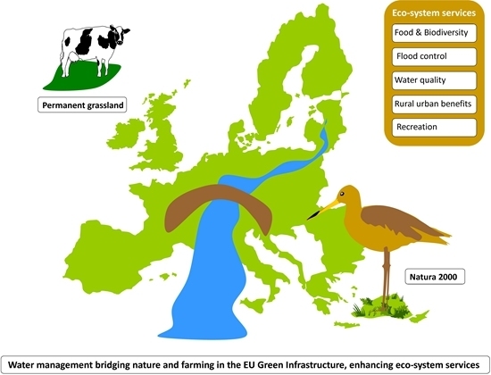
1.1. Green Infrastructure in the European Union

The European Commission has identified Green Infrastructure (GI) investment as an important step in securing the long-term goal of smart, sustainable and inclusive growth throughout the European Union (EU) by protecting and enhancing its natural capital. The working definition adopted for the purpose of EC COM (2013) 249 on GI defines it as “a strategically planned network of natural and semi-natural areas with other environmental features, designed and managed to deliver a wide range of ecosystem services” and notes that it is present in both urban and rural settings [1,2]. The potential of the Common Agricultural Policy (CAP) and the Water Framework Directive are both flagged in the Commission’s Communication as having potential to encourage GI measures. In this paper, we explore these options and synergies with examples from a range of different situations from several regions and Member States to argue that land that was traditionally used for pastoral activities is an underappreciated component of GI that could be mobilised to enhance the network of GI throughout Europe. Such land parcels are generally composed of native species (i.e., have not been sown by people), though the abundance, and sometimes distribution, of their component species has been affected by historic human interventions associated with pastoral practices. These types of semi-natural and natural vegetation, with their high degree of biodiversity value, are thus often included in the Natura 2000 network of European protected sites under the Nature Directives. There are 255 species and 57 habitat types of Community Interest that are closely associated with agriculture [3]. However, in this paper, we make the argument that there is also a case for including intensive agro-systems where at the watershed or landscape level, they form a crucial component of a system, especially where they enhance or deliver on an economically viable system which produces the demanded ecosystem services.
In the European Union and beyond, significant efforts have been made in recent years to assess the economics of ecosystems and biodiversity [4]. The importance of this approach to sustainable development lies in the role of ecosystem services providing not just private but, crucially, public goods and services. These latter services are not internalised in market prizes or traded goods and face difficulties in markets of their own due to a number of market failures. Such goods and services are thus often underprovided. This is a particular issue with ecological systems, such as the grasslands, heaths and grazed moorlands discussed in this paper, which are the product of human-environment interaction over long periods. While these semi-natural systems have been part of the market economy for hundreds of years [5], most now struggle to compete against the modern intensive agro-systems in a world market.

1.2. Changes in Grassland Area in Europe

Due to a decrease in the associated economic productivity, European permanent pasture (including both grasslands and other grazed habitats such as moorland and heath) declined in the twentieth century [5]. Some semi-natural permanent pasture was converted to other forms of land use including non-native forest plantations and re-seeded grassland or cropland [6,7]. In many parts of Europe however, intensification of agricultural production on certain systems and their associated habitats has led to a situation where (apart from intensification) the main threat to these landscapes now comes from abandonment and encroachment of shrub-land [8]. Previously, these grazed habitats had many functions—while providing meat, hay, wool and dairy products, they also produced a vital transfer of nutrients to arable land. This transfer of nutrients was historically of paramount importance and, in areas with poor soils, it provided the only opportunity to sustain arable crops at a time when chemical fertilisers were not yet available [5]. The ingenuity of farmers in making the most of routes to transfer nutrients to where they were most needed even extended to the artificial flooding of meadows in winter to provide nutrients to increase their productivity [9]. Despite historic losses, permanent grasslands still cover 57 million ha of the EU’s Utilised Agricultural Area (UAA) a term used to cover the total area taken up by arable land, permanent pasture and meadow and land used for permanent crops and kitchen gardens [10], while temporary grassland covers about 10 million ha of the EU’s UAA. These categories form respectively 33% and 6% of the UAA [1,8,11]. The EU also has millions of hectares of moorland and heath which may, or may not, be included in the UAA, depending upon the choice a Member State makes about the type of land it includes. We argue that further decline of grasslands and associated grazed habitats may be considered a threat to European biodiversity and the achievement of the goals of the EU Biodiv ersity Strategy [5,12]. In addition, these pastoral habitats provide a number of ecosystem services with the opportunity to use such habitats as delivery tools for a range of services to society apart from food production—for example, flood protection and outdoor recreation—while at the same time enhancing the value of the land for nature [13]. Indeed, integrating GI into the river basin management process had been suggested by the Commission in COM (2013) 249 because of its potential in mitigating the effects of hydro-morphological pressures, reducing the impacts of floods and droughts and contributing to good water quality.

1.3. Future Use of Grasslands

The potential exists for developing a strategic-level ambition to use the pastoral grasslands, heaths and grazed moorlands of the EU to provide a wider range of services to society that, as one of the outcomes, supports biodiversity, while maintaining economically viable management. Tools for achieving this can be developed through ecosystem-based approaches but within this context it is necessary to be aware from the outset that maximising both biodiversity and the provision of other ecosystem services (such as a capacity to be used as flood protection) will not necessarily go hand in hand on every occasion. Nevertheless, in many cases, there seems to be a positive relationship between high nature conservation value and a higher number of ecosystem services [14]. This would imply that despite lower potential agricultural production, the low productive grassland habitats including moorland and heath, are in a good position to obtain additional income from delivering a wider range of ecosystem services. Correct nutrient management will be a vital component, but in many cases, some form of water management will be essential in delivering these additional services. In some cases, nutrient depletion may be prevented by irrigation in winter while others require fertilisation in order to sustain both plant species, productivity for livestock farming and suitable habitat for meadow birds [15]. In the case of moorland and heath, low levels of certain key nutrients must be maintained to secure habitat health and quality. Nevertheless, while the semi-natural, low-intensity grasslands, moorlands and heaths of the EU may be in the best position to deliver a range of ecosystem services, the intensive fertilised grassland farming systems e.g., those used for dairy farming, should not be automatically excluded from a GI role as part of the strategically planned network.

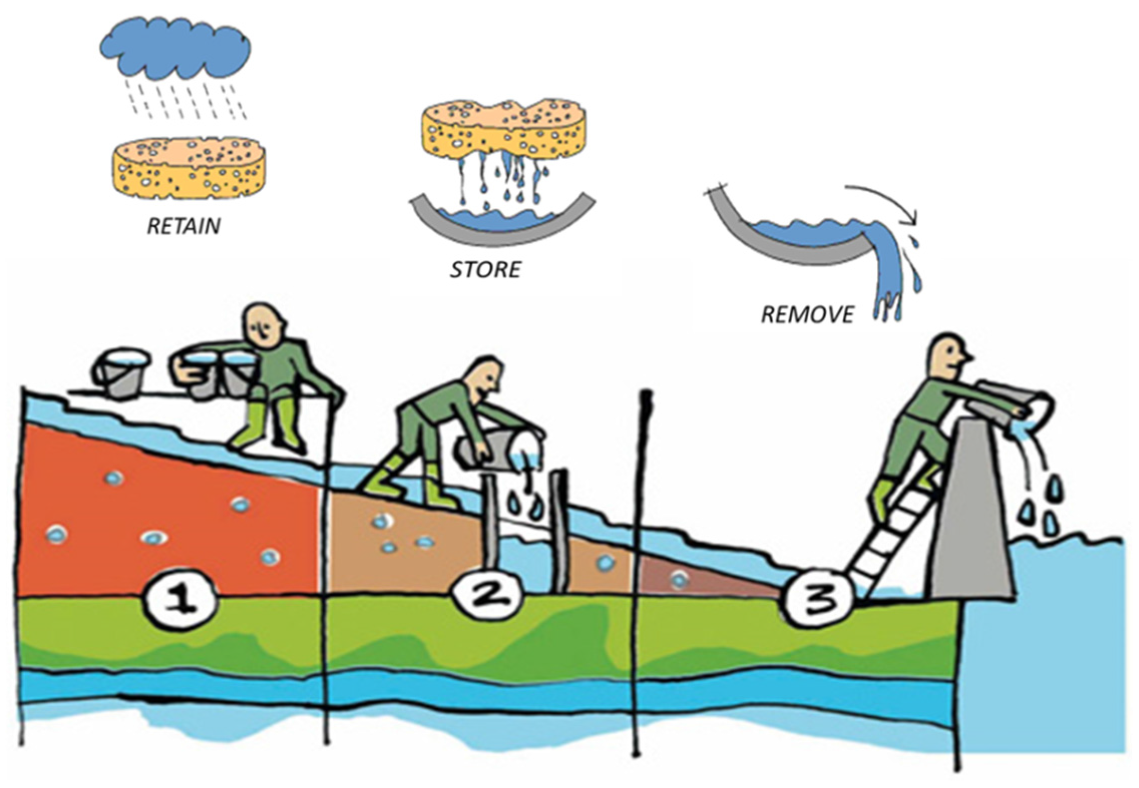
1.4. The Role of Water Management

The integration of GI into river-basin management was proposed by COM (2013) 249 as a means of reducing the impact of floods and droughts, contributing to good water quality and mitigating the effects of hydro-morphological pressures. Historically, at least in northwestern and central Europe, there is a long tradition of water management by drainage and irrigation [9,12,16]. Both are significant agricultural practices which have contributed not only to an increase in agricultural production, but have, as by-products, created opportunities for native species of plants and birds to develop into suites of species associated with agriculture, the meadow bird communities being a prime example of this. Indeed, it is the historic interaction of society, nature and the economy that has created the “high nature value” areas of Europe with their associated suite of semi-natural habitats and bird species. The onset of the creation of polders, for example, and the (usually shallow) drainage of wetlands, became an option at a time when the institutional capacity was in place, capital could be attracted, and food demands in the cities were rising [17]. In the 19th century, flood meadows and water meadows were widespread in Europe [18], but ultimately these innovations could not compete in terms of productivity with the new use of chemical fertilisation on drier land. At the beginning of the 20th century, most of the drained and irrigated land resources continued to generate an environment rich in biodiversity though, by this stage, a crossroads in terms of the benefits versus efforts of agricultural ”improvement” had been reached. In some instances, they were chemically fertilised, ploughed up and turned into intensive grassland (government grants played a role in some decisions rather than strict cost/benefit calculations); however, there were also landholdings where the introduction of mechanisation and chemical fertilisers was not an economically viable option. By the end of the 20th century, many semi-natural grasslands had either been turned into modern re-seeded grassland, aided by mechanisation and chemical fertilisers, or were abandoned for agricultural use and encroached by shrub-land [8,19].

1.5. The Economic Perspectives for Grassland Ecosystem Services

The end result of the changes outlined above is that there are now areas of land which are no longer in a position to deliver their green services for free as a positive externality of the market. One potential solution is to make use of the EU’s Common Agricultural Policy (CAP) and to rethink the present agricultural subsidies. This proposal is not as radical a change as it might appear at first glance since its gestation already began in the 2015–2020 CAP. In the current CAP, one-third of the income support to farmers is already being paid for what we can define as “green” services. The implication is that the process of paying present subsidies to deliver future benefits has already begun [4]. Such an approach may also include taxation as a tool to counteract the negative environmental impacts (negative externalities) of present production. As we argue in this paper, an EU green infrastructure is thus needed in order to capture the various rights involved. Another critical issue is the delivery of the payments required in order to carry out the necessary management of grasslands, moorland and heath so that the long-term economic benefits for society may be captured. Despite these two challenges, the long-term benefits for society of such an approach could be very high. For example, a European Commission (Directorate General Environment)-funded project led by the Institute for European Environmental Policy (IEEP) estimated an annual overall economic benefit provided by the Natura 2000 network of between €200 and €300 billion per year [20]. Fifty percent of this network (or 40 million hectares of land) consists of semi-natural agricultural habitats. The critical question is who will pay the short-term management costs for providing ecosystem services—costs which amount annually to anything between €250–€1000 per hectare [20]—prior to capturing the long-term benefits.

1.6. Objectives

In this paper, we focus on the role that managing and controlling drainage can play in enhancing the positive interaction between grazed habitats (grasslands, heaths and moorlands) in Europe and the provision of ecosystem services such as food production, biodiversity, recreation and protection against flooding. At the same time, controlled drainage (also called environmental drainage or irrigation-drainage systems) can also significantly increase resilience to the effects of a changing climate. Our examples have been selected to demonstrate that this approach has applications across a wide range of pastoral vegetation and in a variety of Member States from the western periphery of the EU through the highly intensively farmed landscapes of the Netherlands and into Germany and the eastern reaches of the EU. In the Netherlands, grasslands are providing recreational services as well as biodiversity, but as we will demonstrate, manipulating drainage will deliver better soil quality and carbon sequestration. In Germany, the complex manipulation of water levels produces a greater variety of biodiversity than would otherwise be the case, while still providing grazing for farmers. In the Czech Republic, drainage systems in mountain meadows deliver important flood protection services as well as contributing to delivery of provisioning services by enabling sub-irrigation to maintain primary production of vegetation during periods of drought. On the western periphery of the EU, the UK still has extensive areas of upland semi-natural vegetation towards the north and west. Although increasingly affected by poor returns from livestock grazing (provisioning services) they have an important role in delivering drinking supplies and, here, manipulation of drainage is focused on reversing historic mistakes to reduce the costs of supplying water. The choice of examples, however, should not be interpreted as necessarily the order of priorities for EU-level action. Based on the authors’ present fields of interest, they were chosen to demonstrate that there would be an advantage in giving serious consideration to the inclusion of pastoral land in the GI and that in the light of scientific understanding of drainage principles, active interventions via manipulation of water in these systems can deliver more and better green services to European citizens.

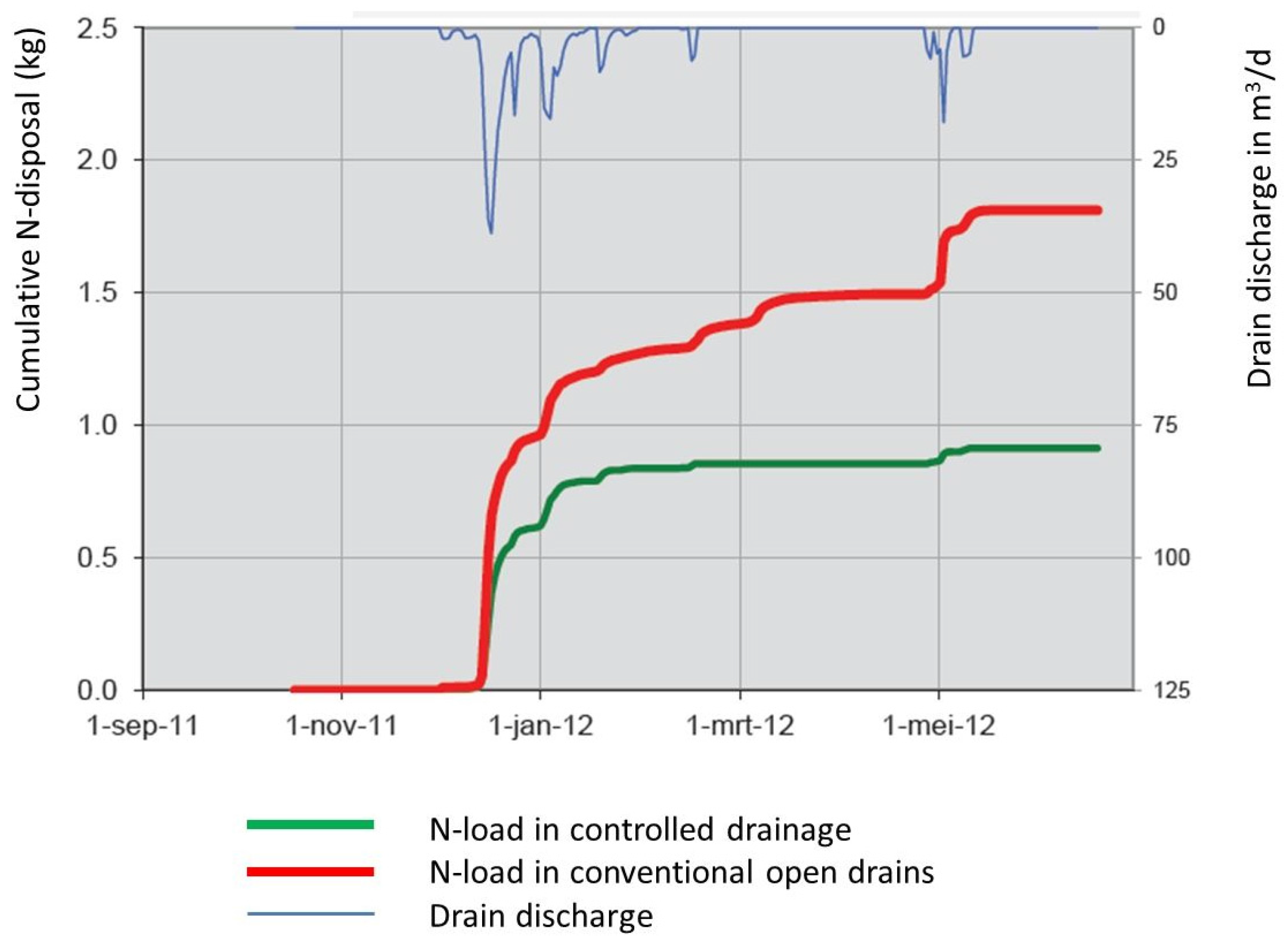
2. Controlled Drainage Options to Combine Land Use Functions on Grasslands in the Netherlands

In the low-lying Netherlands with its significant areas of reclaimed land (50°–54° N and 3°–8° E), 65% of the land surface is protected by dykes to prevent flooding. However, since the average annual precipitation (851 mm) exceeds the average potential evaporation (559 mm), land drainage is subsequently required [21]. Land reclamation in what is now this Member State (MS) dates from around 800 A.D. when drainage was achieved mainly by gravity at low tides [22]. After the Second World War, the capacity of pumped drainage was gradually increased in order to facilitate increased agricultural production [23]. With food security achieved, later changes in land use, i.e., the increase of horticulture, urbanisation and the associated need for recreational and nature areas, required once more the implementation of a fundamental change in drainage management. In modern times, the focus is on reducing drainage outflow by creating more control in the drainage system using a three-step approach [24]. The approach can be summarised as follows: (1) try to retain as much as possible excess water in the field by storing the water on the soil surface and in the soil profile; (2) increase the storage capacity of the drainage system; (3) increase options for controlled removal (Figure 1). This approach allows reduction of outflows during periods of extreme rainfall events, but also improves the water storage capacity in the soil during periods of drought. While both are beneficial for crop production and natural vegetation, the approach also contributes to flood protection. Measures to implement this approach depend not just on soil and hydrological conditions but crucially on the prevailing types of land use in combination with the aforementioned environmental conditions [25]. Therefore, we have selected two major grassland areas in the Netherlands and will outline the opportunities as well as the challenges encountered in the attempt to combine various land use functions in a sustainable way.

2.1. Low-Lying Grasslands in the Western Part of the Netherlands

The grasslands in the western part of the Netherlands are mainly in the low-lying peat areas in the “Green Heart” between the major cities of Amsterdam, the Hague, Rotterdam and Utrecht (between 51°51′–52°38′ N and 4°16′–5°06′ E). These grasslands were traditionally used for dairy farming, through currently many grassland areas have been converted into nature and recreational areas for the inhabitants of nearby cities. Previously, these grasslands on peat were drained by an open drainage system, but to cope with climate change, the concept of a controlled submerged subsurface drainage system was developed, aiming at a more constant groundwater level both in periods of excess rainfall and in dry summer periods [24]. At times of excess rainfall, the submerged drains lower the groundwater level and, in dry periods, the drains act as a sub-irrigation system in which previously infiltrated surface water permits the maintenance of higher groundwater levels in the soil. Thus the soil water table can be kept more horizontal year round compared to the water table in a traditional open drainage system. This horizontal water table is the key to reducing soil subsidence, reducing greenhouse gas emissions, increasing the bearing capacity of the soil in spring and autumn and optimizing grass production [26]. Field trials conducted in 11 pilot areas scattered over the Green Heart area show that this type of controlled drainage can reduce the subsidence in a peat soil between 17% and 58% depending on the drainage intensity [27]. These lower subsidence rates also significantly reduce greenhouse gas emissions. Indeed, both intensive and extensive grasslands on peat are a source of greenhouse gases, but rewetting the peat can reverse this trend to such an extent that the area can once again become a sink (Figure 2).
Controlled drainage experiments in other areas also indicated that the cumulative N-load from the controlled drainage plot was about 47% lower compared to the uncontrolled system (Figure 3) [28].
Restoration is still a delicate affair requiring balancing between: (i) rewetting the peat; (ii) eliminating the use of fertilisers, and; (iii) the presence of natural seeds [30]. It should be borne in mind that, although the raised surface water level reduces greenhouse gas emissions, both gross grass yield and grass quality will become lower. This leads in turn to an increase in the average costs for farmers with €89 ha−1·year−1 for a freeboard of 50 cm, €170 ha−1·year−1 for a freeboard of 40 cm and €239 ha−1·year−1 for a freeboard of 30 cm [31]. If these results are extrapolated over the whole Green Heart area, a higher water table in the Green Heart area could lead to considerably lower grass yields [32]. For an average dairy farm, the losses could amount to €20,000 to €30,000, or €500 to €600 ha−1·year−1. With this higher water table, greenhouse gas emissions can be reduced by about 20 tonnes CO2-equivalent. At a charge of €30 per tonne CO2-equivalent, the reduced carbon emission could compensate for the lower farm output [32]. If the cost structure of arable farming was to be geared towards limiting greenhouse gas emissions and nutrient surpluses (nitrogen and phosphate surpluses), the sector would be more inclined to introduce “smart” reduction in the use of inputs than if the prices of inputs were raised. Farmers need “handles” to work with if they are to be creative in finding more sustainable options.

2.2. Sandy and Loamy Grasslands in Higher Parts of the Netherlands

The sandy and loamy grasslands are located in the higher parts of the Netherlands where the characteristic landscape elements are sandy plateaus intersected by sand and peat stream valleys. Land use is multifunctional: nature, recreation, agriculture and grass lands. The hydrology is characterised by infiltration areas and seepage areas [24]. The higher sandy areas act as infiltration areas, where the precipitation surplus percolates to the groundwater that then resurfaces as seepage in the downstream areas. Agriculture is mainly rain fed, sometimes supplemented by groundwater irrigation. Water management for these multifunctional land uses is a complex affair due to the different requirements. As an example, we discuss water management in a recreation park, “Bussloo”, which is located on the Veluwe in Gelderland province in the middle of a triangle formed by the cities of Apeldoorn, Deventer and Zutphen (52°12′ N, 06°06′ E). The park is managed and operated by a private company, Leisurelands [33]. Formerly known as RGV, Leisurelands was privatised in 1999 with the task of developing, constructing, facilitating, operating and managing recreational products. The company manages 19 parks with a total land area of 2079 ha, 802 ha of which are open water bodies (Figure 4).
These recreation parks are all located in rural areas and aim to combine recreation, agriculture and nature in a sustainable way. In 2014, the parks attracted more than 3.7 million visitors [33]. Designed to be sustainable and to provide access to green space, their contribution to local economies and quality of life is significant with the parks supporting a total FTE employment of over 700 jobs. The 300 ha park at Bussloo includes a lake of 100 ha which is approximately 10 meters deep with a ± 1 m thick clay bottom layer overlaying a sandy aquifer. The lake had been dredged for sand excavation between 1968 and 1977 for the nearby A1 motorway. The park was opened for recreation in 1977. It is located in a so-called “TOP” area, i.e., an area in which intensive drainage has resulted in drought stress due to lower water tables. In 2007, the National Government initiated a plan to rehabilitate 70,000 ha of these TOP areas. For each TOP-area, the Provincial Government has to establish the so-called “Target Ground and Surface Water Level” (“Gewenste Grond—en Oppervlakte water regime”GGOR water regime) [34]. The Water Board has the responsibility of establishing the GGOR water regime, but this has to be done in consultation with all stakeholders in a joint field trial, the “GGOR process.” This process may require a revision of the local water-management plan and such revisions, including the establishment of a target open-water level, can only be carried out after public consultation. In the case of Bussloo, the stakeholders are the Water Board Veluwe, responsible for the management of the surface and groundwater, Leisurelands as the owner of the park, and the De Poll Estate which includes the nature reserve and TOP area known as Appense Veld. As there are no streams or brooks flowing into the lake, the water level in the lake is related to rainfall, evaporation and the groundwater in- and outflow. Surface runoff towards the lake only takes place from a relatively small area around the lake. Groundwater inflow comes from the west and south and these areas, including the TOP-area Appense Veld, have an elevation that is about 3 m higher than the water level in the lake. Groundwater outflow occurs to the north and east sides towards agricultural lands with an elevation below the level of the lake. On the south-east side of the lake there is a gated outlet to a small stream. The only way to manage the water level in the lake is by opening/closing this gate. Inflow takes place mainly in winter when there is a rainfall surplus (around 300 mm). In summer the evaporation surplus is around 120 mm [35]. To establish a GGOR water level regime for the lake, a compromise had to be found between the requirements of Leisurelands and the TOP area Appense Veld. In order to ensure a safe, manageable and attractive recreation park while keeping the costs to an acceptable level, Leisurelands prefers a constant water level, which can be achieved by opening the gate to increase outflow from the lake, especially in springtime. On the other hand, to reduce drought stress in the nature reserve Appense Veld, maximum water levels in the lake are preferred by the Estate De Poll, preferably with no outflow at all, but this results in a strong fluctuation of the water level in the lake. As a compromise, the Water Board has recommended a target water level in winter of 5.20 m +MSL and 4.90 m +MSL in summer [36]. A higher maximum water level would impose several disadvantages for the recreation function i.e., a loss of available beach surface as well as a need of additional shore protection measures (in order to raise shores or prevent calving). It also requires more intensive monitoring of the water level during the year, cleaning the beach more frequently and constantly moving the safety lines to ensure safe bathing. For example, the investment costs to raise the maximum water level in Lake Bussloo by 0.5 m are €500,000 and the annual operation and maintenance costs will increase by approximately €40,000.
Monitoring of the water level indicates that maintaining the target level is very challenging as the main in- and outflow takes place through groundwater flow (Figure 5). In dry periods, the groundwater flow is mainly governed by the water levels in the River Ijssel, located 2.3 km to the east, and the water level regularly drops below the minimum target level of 4.90 m +MSL even when the gate is closed. Consequently, groundwater levels in the adjacent nature reserve are falling, causing drought stress of the natural vegetation. This case demonstrates that water management for combined types of land use, i.e., agriculture, nature and recreation, is complex and requires compromises between the different land use requirements.

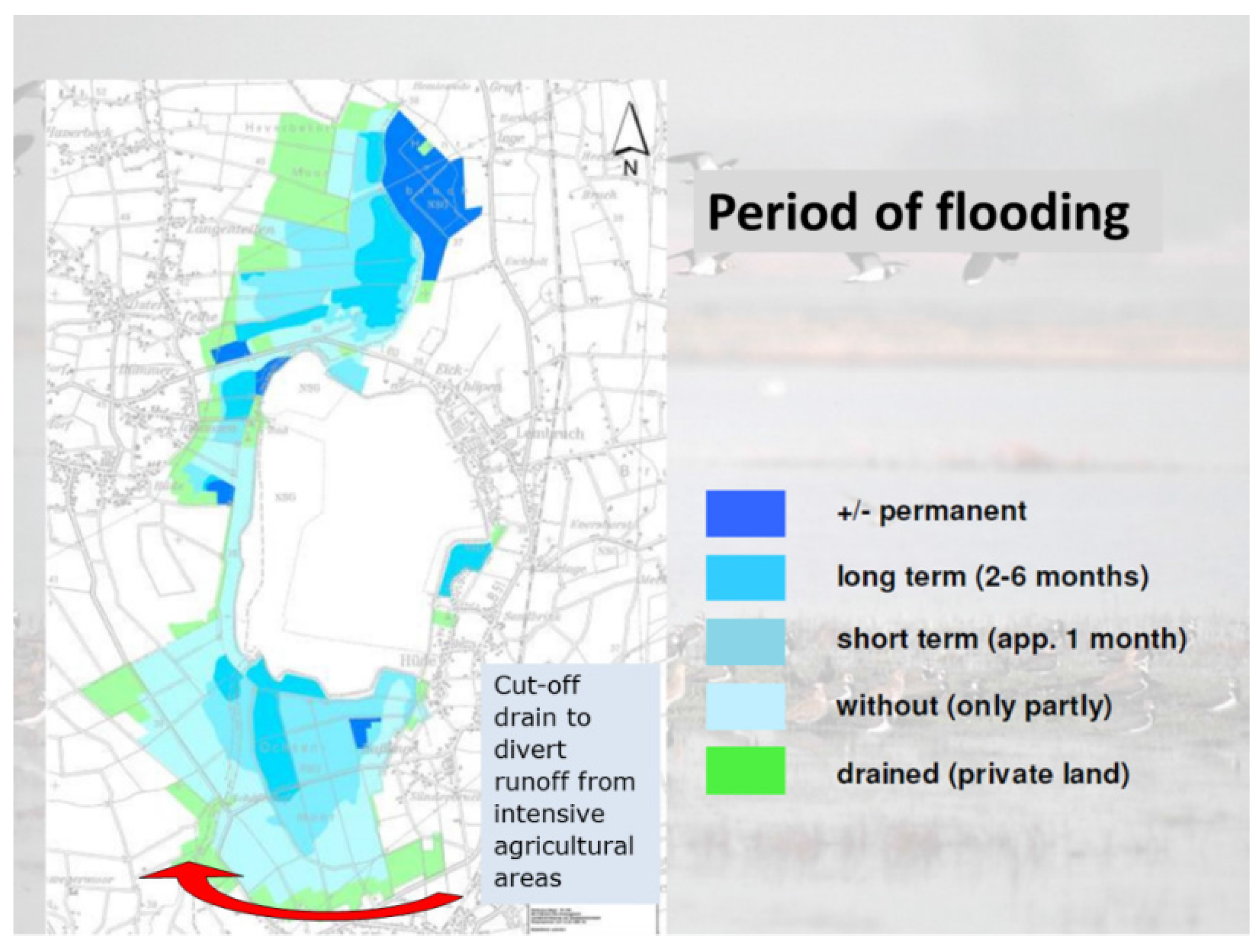
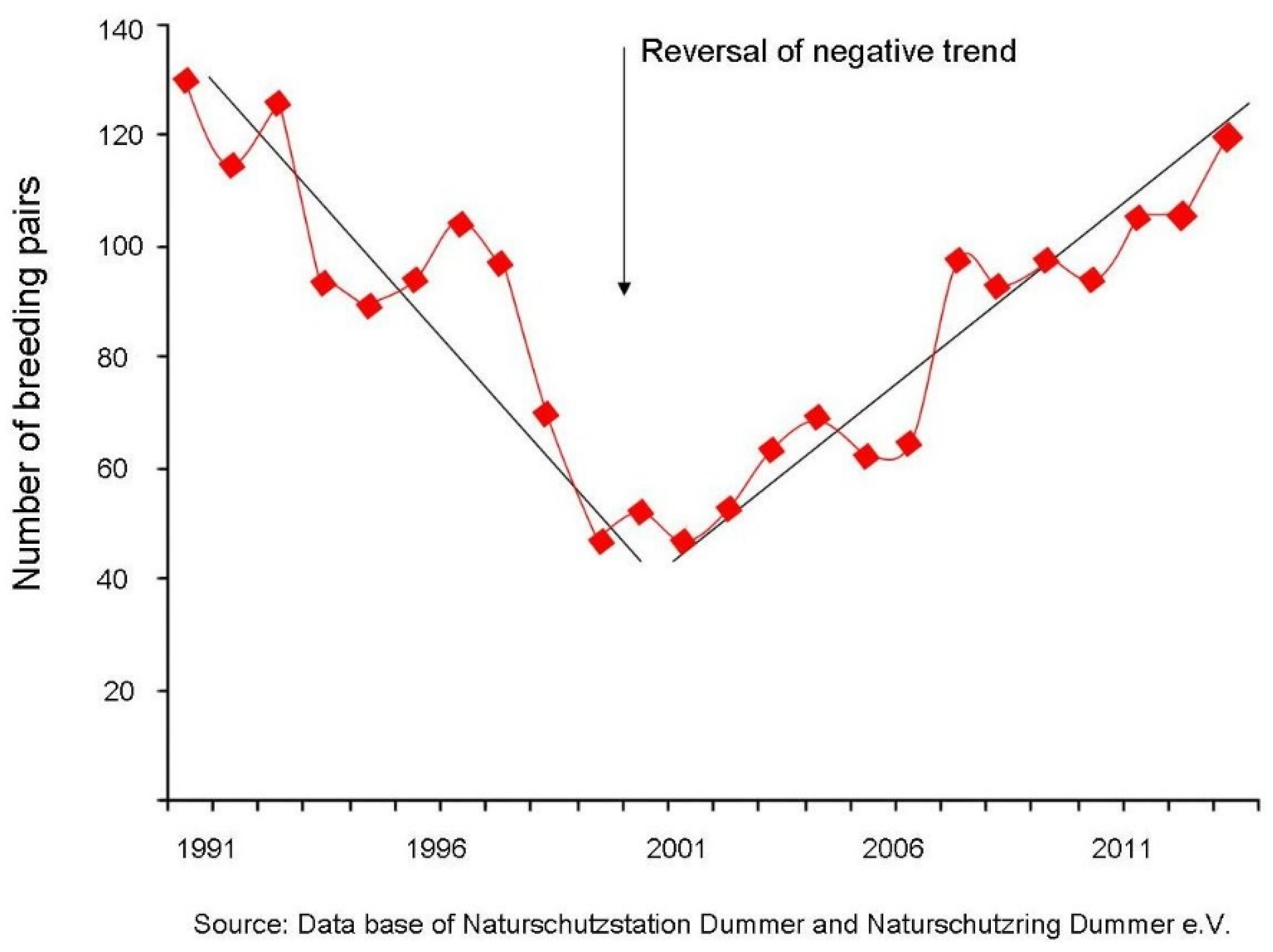
3. Controlled Drainage for Extensive Agriculture and Nature in Germany

In northern Germany, the wetlands of the lowland Dümmer area (4650 hectares) (52°30′ N, 8°19′ E), make up a European Bird Sanctuary of international significance for nature conservation (Special Protected Area of Natura 2000). The diverse natural and near-natural habitats of the Dümmer hold a large number of bird species (reed, wading, water and meadow birds), which breed, rest or winter there [37]. Until 1953, the River Hunte and Lake Dümmer burst their banks every year and this caused extensive flooding of the surrounding fens [37]. The flooding restricted the period of time that the local farmers were able to use the wet meadows for agricultural purposes. The historic, cultivated landscape provided suitable living conditions for a large number of bird species. The dyking of Lake Dümmer in 1953 led to the drainage of the wetlands and the intensification of agricultural activity. This, together with peat cutting in the adjacent bogs, caused the water to become heavily polluted with nutrients. Since 1987, the Federal State of Lower Saxony has been involved in a regeneration project: “Dümmersanierungsprojekt.” Within the framework of two LIFE Nature projects, controllable rewetting of the meadows in the Lake Dümmer lowlands was initiated [37,38]. In the Ochsenmoor Fen an area of about 1000 hectares was rewet between 1998 and 2000. Another area of 1300 hectares was rewet in the western Lake Dümmer fen area between 2002 and 2007. Approximately €40 million were invested in the purchase of land and in measures for nature protection. This meant that a total area of 2500 ha was successfully consolidated in the Natura 2000 Area of Lake Dümmer. In order to rewet the lowlands, 50 adjustable weirs and dozens of small dams, as well as three electrical water pumps, were built to control water levels in 80 km of drainage ditches. These measures aim to develop a large wet grassland area of suitable meadow bird habitat by re-establishing the previous typical water levels for the area from before dykes were put in place. The goal is to ensure sustainable usage of the grasslands in a way that supports nature conservation and precise and targeted control of drainage is a key tool. Flooding in winter and slow step-by-step drainage during early and late spring recreates suitable habitats for numerous species of meadow birds threatened with extinction [37]. At the same time the meadows can still be used by the local farmers for summer grazing. During the summer season, the adjustable weirs are kept open so that the water level drops about 40 cm below ground. Additional small dams ensure that the minimum water level in the sensitive fens does not drop more than the 40 cm below ground. At the end of the grazing season, around November and early December, the adjustable weirs are closed to maintain water levels of about 10 cm above ground. Depending on the amount of rain, the water level rises in the ditches and the surrounding area gets slightly flooded. In spring, the weirs are opened, again, in a step-by-step manner to make sure that the pastures are dry enough in summer to be used for grazing. The control of the water table varies per polder and some parts are permanently flooded or drained, whereas for others it is a seasonal impact (Figure 6). On grazing land, water levels are lowered from March at the latest to ensure that cattle do not damage the pasture, while in very wet areas of grassland where the grass is cut for harvesting, it is possible to delay water level drawdown until the end of May or even later. This range of water levels in the polders creates a huge diversity of habitats in the area. The conservation areas are leased out to over 100 local farmers and the area is managed by the local nature conservation centre Naturschutz Station Dümmer (Lower Saxony Water Management, Coastal Defence and Nature Conservation Agency) whose staff ensure that the conservation goals for the EU birds and habitats are achieved (Figure 7). At the same time, the farmers remain part of the project through their usage and maintenance of the meadows in a manner consistent with nature conservation. Separate contracts for individual farmers, including manure rights and other ground-related certificates, are valued differently according the structure of the farming system but can reach up to a maximum of €2000 ha−1·year−1.

4. Controlled Drainage on Grassland for Flood Control in the Czech Republic

Grasslands have a high retention capacity and, by the introduction of controlled drainage, the flood risk can significantly be reduced. In the Czech Republic, with its favourable soil hydrology (hydro-pedology) conditions, grasslands make up 12% of the total land area. In mountain meadows, controlled drainage increases the drainage retention capacity (DREC) and thus such grasslands play a key role in flood protection [39].
In saturated soils, drainage systems decrease the level of the groundwater table and thus enable the creation of groundwater reservoirs, i.e., drainage retention capacity (DREC). DREC, based on the hydraulic functions of a drainage system, can be defined as a groundwater reservoir, created by the action of a drainage system, which is limited by soil surface and by the shape of the groundwater level between two parallel neighbouring drains [40,41]. DREC has the potential to mitigate the negative impact of extreme weather events in the form of floods or rainstorms. Control of the groundwater level above the drains (both pile and open drains) can be achieved by managing small mobile gates placed in the drain. On the other hand, during periods of prolonged droughts, the controllable gates can increase the water level in the system of drainage ditches, thus enabling subirrigation (Figure 8).
The DREC concept was used to restore surface drainage systems in 1.5 ha of mowed mountain meadow with inoperative, non-functional ditches in the Krisak agricultural area (50°7′ N, 15°2′ E) located in the Jizera Mountains, Northern Bohemia [42]. The geological bedrock of the Krisak locality belongs to the Jizera type. The upper soil layers of a forested area, composed of organic sediments and partly peat soils, are very permeable, with an average hydraulic conductivity of about 0.86 m·day−1 and effective porosity of 0.096. Through the impact of high precipitation, the soil micro-particles percolate to the deeper layers, i.e., to a permeable barrier with concave character, which is located approximately 1.0 m below the surface. The reconstruction of the surface drainage system consisted of deepening, cleaning and a general reconstruction of the present non-functional drainage ditches and the installation of small water gates to manage the open water level in the drainage ditch (Figure 9). The groundwater reservoir, located between the terrain surface and the groundwater table above the free water level in the renovated drains, with the drainage retention capacity (DREC), can serve as an infiltration area reducing surface runoff. Drainage retention capacity (DREC) in the mountain meadows at Krisak is in the range of 36 to 92 mm (Table 1).
The Jizera Mountain region has high precipitation rates. Long-term annual precipitation is about 1020 mm·year−1, including extreme rainfall events which cause flash floods. On 9 June 2010, for example, 90 mm of precipitation in 2 h was recorded at Krisak and in August 2010 the entire area of the Jizera Mountains was impacted by intense rain storms (100.6 mm on 6 August and 112.0 mm on 7 August) causing massive flash floods. A total of five flood-related casualties were reported. Simulations have shown that DREC can reduce flash formation and can significantly mitigate negative impacts of floods [43]. The corresponding socioeconomic costs of an alternative measure, i.e., water reservoirs, is around €15/m3. At Krisak, DREC values from 36 mm to 93 mm (Table 1) represent a volume in the range of 360 to 930 m3/ha which shows that the socioeconomic benefits of DREC are in the range of €5400 to €13,950 per hectare (Figure 10) compared to the cost of the renovation of the surface drainage of around €2000/ha [44].

5. Drainage and Peatlands in the United Kingdom

The uplands of the UK (England, Scotland, Wales, Northern Ireland) with their extensive areas of semi-natural grassland, heath and moorland are of high nature value (reflected in significant areas being designated as Natura 2000 sites) [46]. From an international perspective, the UK also contains around 13% of the total world blanket bog [47], generally an upland habitat, though it comes down to much lower altitudes in the highly oceanic north and western fringes, as well as a number of remaining areas of lowland mires. While the UK uplands have a long history of livestock grazing, this use has become increasingly economically marginal, and farm incomes more dependent on CAP payments than market prices. However, the UK uplands are important for a much wider range of ecosystem services than meat and wool. In the UK as a whole, for example, 70% of the drinking water comes from surface water derived mainly from catchments in the uplands with their extensive areas of peat soils [47], whereas in Northern Ireland, the region’s water company abstracts 95% of its water from surface water sources. In addition, the UK is among the most extensively drained parts of Europe [48]. Smout [49] estimated that about 5 million hectares of the UK lowlands had been drained by “improvers” by the nineteenth century. In Northern Ireland, for example, about 50% of the total agricultural land has had some form of field drainage since 1947. Drainage has also been carried out in the upland peatlands, driven by two factors: the use of peat for fuel and also with the aim of increasing the carrying capacity of the land for livestock although some attempts were directed at the game species, the red grouse (Lagopus lagopus). As a technique, drainage has been so widely applied in the UK and so much a feature of farming there that its efficacy seems to have been taken for granted until otherwise proven [50]. Ballard [51], for example, noted that despite the popularity of moor-draining (or moor-gripping as it was known in England) only localised the draw-down of the water table. However, the legacy of poor application of drainage-management principles is now known to have implications for water treatment and associated costs. Drainage in blanket peat can lead to changes in peat structure wherever it dries, shrinks and decomposes, and higher flow velocities in the ditches can speed up the movement of water into upland streams when it rains [48]. Dissolved organic carbon (DOC) adds colour to water and therefore increases treatment costs to the water company. Interventions to improve ecosystem service provision in terms of drinking water supply have focused on blocking up the drains in the peat. The first attempts to block upland peat drains took place in the 1980s [52] and in England, only about 5% have been blocked to date [53]. Given the rugged and remote nature of the terrain, such interventions are not simple and we would argue that initiatives to block drains in the name of ecosystem service improvement require as much informed input by water engineers as drainage initiatives in the other systems described in this paper. Indeed, Holden et al. [54] noted that most of the studies associated with peatland drainage undertook limited measurement of the hydrological processes.
Now viewed as economically marginal land, the UK uplands have a long history of use for livestock grazing [55,56]. Despite fortunes made by some historic landowners [57], however, present-day farming survives only as a result of possible CAP payments [58,59,60]. In order to improve the ecosystem services delivered by these moors and grasslands, it is clear that there needs to be improved catchment management so that not only can further mineralisation of the carbon resource be avoided, but also so the capacity of the land to provide cost-effective drinking water supplies can be maintained.

6. Discussion

In the introduction to this paper, we argued that there were pastoral habitats in the EU that, even though they were marginal, or becoming increasingly marginal for livestock grazing in current world market conditions, currently deliver important ecosystem services as by-products that, with appropriate intervention via water-management techniques (smart drainage) had the potential to deliver a better and wider range of such services.
In the oceanic west of the EU, the UK example shows that developing and using our scientific understanding of how water is retained in, and moves through, peat substrates enables water companies to deliver a vital service to society in a more cost-effective way. Some UK private water companies, such as United Utilities, are now providing payments to farmers to manage land to deliver water as well as food and fibre. This reverses the twentieth-century trend of uncontrolled drainage and contributes to the objectives of the Water Framework Directive. The increased income to farmers means that certain grazed habitats can still be maintained in favourable conditions for nature. Further into continental EU, a similar scientific approach to soils under mountain meadows in the Czech Republic has been shown to reduce peak runoff rates, thereby increasing resilience to high rainfall events and contributing to a reduction in the impact of floods in urban areas. It is also a cheaper alternative to government provision of water reservoirs. Grasslands are much more effective in decreasing the runoff peak than cereal fields, and studies show that discharge from grasslands is 0.23 m³/s, whereas from cereal fields, it is 0.44 m³/s [44]. In Germany, controlled drainage has enabled intensive farming and biodiversity to co-exist, delivering a much wider range of biodiversity than would be the case without this intense manipulation of drainage conditions. At lake Dümmer (D), historic over-drainage caused peat mineralisation and shrinkage. The German work has relevance for all Natura 2000 habitats managed for meadow bird protection. In this case, over-drainage had caused peat mineralisation, oxidation of the peat and consequent shrinkage of the peat layer. The result was a decline in meadow birds over the period 1953–1985 [37,38]. Within the framework of a project funded through EU LIFE, it was possible to build a system for rewetting that had the flexibility to produce the high winter water levels while maintaining low summer levels. It is thus possible to use land in summer for extensive grazing of livestock, which in turn contributes to the habitat conditions that support bird diversity. A polder approach is used with independent water-management units and drainage is cut off from the intensive agricultural land-management units in order to avoid an inflow of nutrients into the nature reserve. This approach has been so successful that similar water-management activities have begun in another 12 areas in Lower Saxony while there are plans for a further project in the Lake Dümmer area. In the intensively farmed landscape of the Netherlands, new approaches to drainage on the peat soils are being adopted to increase the economic and environmental sustainability of their farming practices. A new three-step approach is being used, including retaining as much water as possible on grasslands and removing only the excess water. This enables a reduction of peak discharges of 5%–28% (depending on soil and hydrological conditions). The new approach also enables better use of nutrients/fertilisers while reducing the costs of nutrient input for the farmers, thereby improving profit margins. This system for rewetting peat soils has the potential, under certain conditions, to control nitrogen pollution by managing water, thereby contributing to the objectives of the EU Nitrates Directive. However, lest we be accused of underplaying the complexities associated with trade-offs between different ecosystem services, we have also introduced the case of Bussloo (NL) where governance arrangements had to strike a balance between nature and recreation provision, a balance that required a strong understanding of the drainage systems and an ability to manipulate water to reduce operating costs for the recreational interests while avoiding drought stress on the nature area.

7. Conclusions

Examples provided in this paper indicate that water management and smart control of drainage are important tools for achieving a wider range of ecosystem services from pastoral land, in addition to delivering efficiencies for farmers (e.g., via better nutrient management) and it can provide considerable benefits for biodiversity alongside food production. We began this paper, however, by noting that traditionally many of the ecosystem services of the pastoral landscapes of the EU were delivered as by-products of livestock production. The profitability of this livestock production is declining and—given the wide range of ecosystem services that grasslands, heaths and moorlands deliver for Europe’s citizens—the main challenge is to secure sufficient income for the farmer or land manager so that these can be maintained into the future. The increased efficiency of industrial or intensive systems [61], combined with effects from trade and world market agreements, means that in many regions the income from traditional products is unlikely to be sufficient to incentivise continued farming, with resulting threats to the long-term sustainability of ecosystem services. Effective and efficient water management can, through innovation, contribute to an effective provision of wider ecosystem services, and, where necessary, improve efficiency in manure and fertiliser use, help contribute to a reduced cost of drinking water provision and play a pivotal role in green flood protection systems. While examples exist which demonstrate the technical feasibility of this approach [19,23,62], more information on the economics of the systems will be required in order to assess how this approach could be rolled out more widely as a EU policy initiative. In order to be effective and cost efficient in provision of ecosystem services, water management needs to operate at a watershed or landscape level although, in most EU regions, this level of land unit is far above that held by the individual landowner. Therefore, concerted efforts at the EU level will be required in order to achieve the necessary integration of policy sectors and land categories such as UAA, forest land and Natura 2000 sites. EU investment in farming alone, or tourism alone, or nature alone, is not an economically efficient way of obtaining a range of ecosystem services from grasslands and other extensively grazed land present in the EU. The idea of Green Infrastructure provides a unifying concept that permits this necessary integration in the EU [63]. As the concept of GI is rolled out in the spatial planning and regional strategies of Member States (MS), the full realisation of the EU concept of Green Infrastructure to include rural as well as urban space is necessary. Such a wider approach towards GI would correspond to the wider approaches towards GI used in the US, providing better opportunities for integration of land use to an extent where the concept also integrates environmental and economic sustainability [64]. This would support the necessary landscape and watershed approach required to capture the “in demand” private and public services. Habitats formerly grazed but now abandoned could be included, along with marginal land, i.e., the natural and semi-natural grasslands, heath and moorland. Member States could also opt to include more intensively farmed land provided negative side-effects of intensification can be decreased and positive side-effects i.e., the delivery of ecosystem services, can be increased. By including grassland and grazed habitats, the surface of the EU covered by Green Infrastructure could be effectively doubled. In turn, recognition of land as part of the strategic Green Infrastructure of the region or MS could provide the framework to capture the financial instruments that would permit investment in the public and private service-valued ecosystem services such as flood protection, carbon sequestration, wildfire prevention and restoration of cultural landscape and bio-based farming. Already in the Common Agricultural Policy, there are policy trends (already 30% of the funding of the CAP is de facto no longer for farm income support, but for providing ecosystem services (31)) which, if developed further, embedded in sustainable development strategies and linked to other strategic priorities of the EU via the GI concept, could result in smarter, cheaper and more effective delivery of these valued services.

Acknowledgments

The present paper is an outcome of the international workshop “Enhancing the Economic Viability of Grasslands by Green Farming in Europe” organised by the Life Viva Grass project of the Baltic Environmental Forum and its associate the Rural European Platform, Plosti, Latvia 27–31 May 2015. A presentation on the subject of this paper was presented during a CEEweb workshop: Building Blue-Green Infrastructure 6–8 October 2015 of the CEEweb in Budapest by Herbert Diemont and Hilary Kirkpatrick. The authors thank the project leader Kestutis Navickas of Viva Grass and the referees for useful comments on an initial draft of the paper. © of the info-graphic abstract by Kokotopia:www.kokotopia.nl.

Author Contributions

Henk Ritzema supervised the water issues and wrote the Dutch contributions with an input by Hans Heinhuis. Hilary Kirkpatrick, supported by Herbert Diemont were responsible for the introduction, discussion and conclusions. Jakub Stibinger provided the case study from the Czech Republic. Heinrich Belting provided the German case study and Raymond Schrijver checked the economic data throughout the paper.

Conflicts of Interest

The views of the authors associated are their own and do not necessarily reflect the view of their governments. The authors declare no conflict of interest.

References

  1. European Commission. Communication from the Commission to the European Parliament, the council, the European Economic and Social Committee and the Committee of the Regions: Green Infrastructure (GI)—enhancing Europe’s Natural Capital. COM (2013) 249 final, Brussels. Available online: http://ec.europa.eu/environment/nature/ecosystems/docs/green_infrastructures/1_EN_ACT_part1_v5.pdf (accessed on 25 April 2016).
  2. EEA. Green Infrastructure and Territorial Cohesion: The Concept of Green Infrastructure and Its Integration into Policies Using Monitoring Systems; European Environmental Agency: Copenhagen, Denmark, 2011. [Google Scholar]
  3. European Commission. Farming for Natura 2000: Guidance on how to support Natura 2000 farming systems to achieve conservation objectives, based on Memeber States good practice experiences. 2014. Available online: http://ec.europa.eu/environment/nature/natura2000/management/docs/FARMING%20FOR%20NATURA%202000-final%20guidance.pdf (accessed on 25 April 2016).
  4. European Communities. The Economics of Ecosystems and Biodiversity—An Interim Report. 2008. Available online: http://ec.europa.eu/environment/nature/biodiversity/economics/pdf/teeb_report.pdf (accessed on 25 April 2016).
  5. Diemont, W.H.; Heijman, W.J.M.; Siepel, H.; Webb, N.R. Economy and Ecology of Heathlands; KNNV Publishing: Zeist, The Netherlands, 2013; p. 462. [Google Scholar]
  6. Kirkpatrick, A.H.; Sydes, A.H.; Rushton, B.S. Agricultural Intensification and Loss of Heather Moorland: A case study from Fair Head, Nothern Ireland. J. Pract. Ecol. Conserv. 1999, 2, 33–47. [Google Scholar]
  7. Tudor, G.J.; Mackey, E.C. Upland land cover change in post-war Scotland. In Heaths and Moorland: Cultural Landscapes; Thompson, D.B.A., Hester, A.J., Usher, M.B., Eds.; HMSO: Edinburgh, Scotland, 1995. [Google Scholar]
  8. Huyghe, C.; De Vliegher, A.; van Gils, B.; Peeters, A. Grasslands and Herbivore Production in Europe and Effects of Common Policies; Éditions Quae: Versailles, France, 2014; p. 323. [Google Scholar]
  9. Emanuelsson, U. The Rural Landscapes of Europe: How Man has Shaped European Nature; The Swedish Research Council Formas: Stockholm, Sweden, 2009; p. 383. [Google Scholar]
  10. European Commission. Commission Regulation (EEC) No.649/87 of 3 March 1987. Off. J. Eur. Union 1987, 62, 10–17. [Google Scholar]
  11. EUROSTAT. Agri-environmental indicator—cropping patterns. Available online: http://ec.europa.eu/eurostat/statistics-explained/index.php/Agri-environmental_indicator_-_cropping_patterns (accessed on 26 April 2016).
  12. Dirksen, W. Water management structures in Europe. Irrig. Drain 2002, 51, 199–211. [Google Scholar] [CrossRef]
  13. Fontein, R.J.; Michels, R.; Linderhof, V.; Goossen, M.; de Graaff, R. The Potency of Nature Combinations; Insights and Reflections on the Value of a New Concept; Wageningen UR: Wageningen, The Netherlands, 2015; p. 56. (In Dutch) [Google Scholar]
  14. Schrijver, R.A.M.; Diemont, H.W. High nature value farming and food security in Europe. In Economy and Ecology of Wetlands; Diemont, W.H., Heijman, W.J.M., Siepel, H., Webb, N., Eds.; KNNV Publishing: Zeist, The Netherlands, 2013; pp. 51–62. [Google Scholar]
  15. Diemont, H.; Belting, H.; Siepel, H. Sustaining restoration through integrated farming. Contribution to the SER Europe Knowledge Base on Ecological Restoration. 2013. Available online: www.ser/Europe.org (accessed on 26 February 2016).
  16. Rotherham, I.D. Lessons from the past—A case study of how upland land-use has influenced the environmental resource. Asp. Appl. Biol. 2008, 85, 85–91. [Google Scholar]
  17. Blackbourn, D. The Conquest of Nature: Water, Landscape and the Making of Modern Germany, 1st ed.; W.W. Norton &Company Ltd.: New York, NY, USA, 2006; p. 468. [Google Scholar]
  18. Cook, H.; Williamson, T. Water Management in the English Landscape; Edinburg University Press: Edinburgh, UK, 1999. [Google Scholar]
  19. Tinch, R. Assessing socio/economic benefits of Natura 2000—A case on the ecosystem service provided by the Sustainable Catchment Management Programme. 2009. Available online: http://www.ieep.eu/assets/633/ukscamp_casestudy_final_Aug_09.pdf (accessed on 26 April 2016).
  20. International Institute for Education Planning. Estimating the Overall Economic Value of the Benefits provided by the Natura 2000 Network; Final Report; International Institute for Education Planning, UNESCO: Paris, France, 2011. [Google Scholar]
  21. Koninklijk Nederlands Meteorologisch Instituut/KNMI. Meteorological Data of the Netherlands. 2015. Available online: http://www.knmi.nl/kd/daggegevens/selectie.cgi (accessed on 13 November 2015).
  22. Van de Ven, G.P. Man-Made Lowlands: History of Water Management and Land Reclamation in the Netherlands; Stichting Matrijs: Utrecht, The Netherlands, 2004; p. 293. [Google Scholar]
  23. Barraqué, B. Past and future sustainability of water policies in Europe. Nat. Resour. Forum 2003, 27, 200–211. [Google Scholar] [CrossRef]
  24. Ritzema, H.P.; Stuyt, L.C.P.M. Land drainage strategies to cope with climate change in the Netherlands. Acta Agric. Scand. Sect. B 2015, 65, 80–92. [Google Scholar] [CrossRef]
  25. Van de Sandt, K.H.; Goossen, H.; Vos, C.C.; Hermans, T.; Verhagen, J.; Agricola, H.J.; Kwakernaak, C.; Stuyt, L.C.P.M.; van Ierland, E.C.; Kuikman, P.J.; et al. Klimaatadaptatie in het landelijk gebied. Verkenning naar wegen voor een klimaatbestendig Nederland; Alterra Wageningen UR: Wageningen, The Netehrlands, 2010; p. 110. (In Dutch) [Google Scholar]
  26. Staarink, H. Water Conservation and Controlled Drainage—A Modelling Study for an Experimental Field in the Netherlands. Master’s Thesis, Wageningen University, Wageningen, The Netherlands, 2014. [Google Scholar]
  27. Den Hartogh, J.H. The Impact of Submerged Drainage on Groundwater Level, Soil Subsidence, Bearing Capacity, and Grass Production. Master’s Thesis, Wageningen University, Wageningen, The Netherlands, 2014. [Google Scholar]
  28. Kselik, R.A.L.; Stuyt, L.C.P.M. Field experiments “Nitrogen at the right level” in the South-west of the Netherlands (2007–2011). In Regelbare Drainage Als Schakel in Toekomstbestendig Waterbeheer; Alterra Wageningen UR: Wageningen, The Netherlands, 2013; pp. 177–188. Available online: http://www.stowa.nl/upload/publicaties/STOWA%202013-18def.pdf (accessed on 26 April 2016). (In Dutch)
  29. Stuyt, L.C.P.M.; van der Bolt, F.J.E.; Snellen, W.B.; Groenendijk, P.; Schipper, P.N.M.; Harmsen, J. Controlled drainage: Principles, performance, practical experiences, changes and risks. 2013. Available online: www.futurewater:nl/kad (accessed on 28 April 2016). (In Dutch)
  30. Woestenburg, M. What about the Peat—Knowledge to Make Choices in the Western Peatland Areas; Uitgeverij Landwerk, Wageningen and Alterra Wageningen UR: Wageningen, The Netherlands, 2009; p. 120. (In Dutch) [Google Scholar]
  31. De Vos, J.A.; van Bakel, P.J.T.; Hoving, I.E.; Smidt, R.A. Raising surface water levels in peat areas with dairy farming Upscaling hydrological, agronomical and economic effects from farm-scale to local scale. Agric. Water Manag. 2010, 97, 1887–1897. [Google Scholar] [CrossRef]
  32. Brouwer, F.M.; Smit, A.B.; Verburg, R.W. Economic incentives for greening agriculture. In The Statutory Research Tasks Unit for Nature & the Environment (WOT Natuur & Milieu); Wageningen UR: Wageningen, The Netherlands, 2015; p. 92. [Google Scholar]
  33. Leisure Lands. Leisure Lands: Sustainable Recreation; Leisure Lands: Arnhem, The Netherlands, 2015; p. 79. Available online: http://www.leisurelands.com/ (accessed on 29 April 2016). (In Dutch)
  34. KADER. Vierde Nota Waterhuishouding: Regeringsbeslissing; Ministerie van Verkeer en Wasterstaat: The Haque, The Netherlands, 1998. (In Dutch) [Google Scholar]
  35. Oosterbaan, R.J. Agricultural Drainage Criteria. In Drainage Principles and Applications; Ritzema, H.P., Ed.; ILRI Publication: Wageningen, The Netherlands, 2006; pp. 635–690. [Google Scholar]
  36. Jansen, J. System Analysis Bussloo; Royal Haskoning: Amsterdam, The Netherlands, 2012; p. 34. (In Dutch) [Google Scholar]
  37. Belting, H. LIFE Nature Projects for the Rewetting of Lake Dümmer Lowlands; Flyer, Naturschutzstation Dümmer: Hüde, Germany, 2007; p. 11. [Google Scholar]
  38. Belting, H. Experiences from the LIFE project “Rewetting of Lake Dümmer lowlands”. In Report from the EU LIFE-Nature Seminar on Restoration of Meadow Bird Habitats; LIFE-Nature: Copenhagen, Denmark, 2009. [Google Scholar]
  39. Kovar, P.; Stibinger, J. Methodology for Infiltration and Retention Measures to Restore the Water Regime in Landscape; Ministry of Agriculture of the Czech Republic: Prague, Czech Republic, 2010. (In Czech) [Google Scholar]
  40. Luzice Mountain Company. Renovation of Wetland “Na Brazilce” at Luzice Mountains, Czech Republic; Provincial Office Lobau-Zittou: Zittau, Germany, 1999. (In Czech) [Google Scholar]
  41. Stibinger, J. Drainage retention capacity (DREC) to reduce runoff in drained areas (Malinik Forest area, Czech Republic). Irrig. Drain. 2016, in press. [Google Scholar]
  42. Stibinger, J. Drainage Retention Capacity (DREC) of Krisak Mountain Meadows Agricultural Area (Jizera Mountains, Czech Republic) for Mitigation of Negative Impacts of Climate Change. 2014. Available online: http://www.elsevier.com/electronic-products/procedia (accessed on 25 April 2016).
  43. Stibinger, J. Drainage Retention Capacity (DRC) of Surface Soil Layers to Mitigate Negative Impact of Climate Dynamics. NJF Drainage Seminar 462, “Does Climate Change Demand a New Approach to Drainage Design?”; Nordic Association of Agricultural Scientists (NJF): Bioforsk, Norway, 2013; pp. 33–34. [Google Scholar]
  44. Šišák, L.; Šach, F.; Švihla, V.; Pulkrab, K.; Černohous, V. Methodology of Assessment of Social-Economic Functions in Nature; CULS Prague: Czech Republic, 2010; (In Czech, abstract in English). [Google Scholar]
  45. Peskova, J.; Stibinger, J. Computation Method of the Drainage Retention Capacity of Soil Layers with a Subsurface Pipe Drainage System. Soil Water Res. 2015, 10, 24–31. [Google Scholar] [CrossRef]
  46. McLeod, C.R.; Yeo, M.; Brown, A.E.; Hopkins, A.J.; Way, S.F. The habitats Directive ± selection of Special Areas of Conservation in the UK. 2005. Available online: www.jncc.gov.uk (accessed on 25 April 2016). [Google Scholar]
  47. International Union for Conservation of Nature (IUCN). Commission of Inquiry on Peatlands: Summary of findings. 2011. Available online: htpp://iucn-uk-petlandprogramme.org/ (accessed on 26 April 2016).
  48. Holden, J.; Chapman, P.J.; Labadz, J.C. Artificial drainage of peatlands. Prog. Phys. Geogr. 2004, 28, 95–123. [Google Scholar] [CrossRef]
  49. Smout, T.C. Nature Contested: Environmental History in Scotland and Northern England Since 1600; Edinburgh University Press Ltd.: Edinburgh, UK, 2000; p. 210. [Google Scholar]
  50. Kirkpatrick, A.H. Managing moorland in the UK. In Economy and Ecology of Heathlands; Diemont, W.H., Heijman, W.J.M., Siepel, H., Webb, N., Eds.; KNNV Publishing: Zeist, The Netherlands, 2013; pp. 323–337. [Google Scholar]
  51. Ballard, C.E.; McIntyre, N.; Wheater, H.S.; Ballard, H.S.; Wheater, H.S. Effects of peatland drainage management on peak flows. Hydrol. Earth Syst. Sci. 2012, 16, 2299–2310. [Google Scholar] [CrossRef] [Green Version]
  52. Armstrong, A.; Holden, J.; Kay, P.; Foulger, M.; Gledhill, S.; McDonald, A.T.; Walker, A. Drain blocking techniques on blanket peat: A framework for best practice. J. Environ. Manag. 2009, 90, 3512–3519. [Google Scholar] [CrossRef] [PubMed]
  53. Holden, J. A Grip-Blocking Overview; School of Geography, University of Leeds: Leeds, UK, 2009; p. 16. [Google Scholar]
  54. Holden, J.; Shotbolt, L.; Bonn, A.; Burt, T.P.; Chapman, P.J.; Dougill, A.J.; Fraser, E.D.G.; Hubacek, K.; Irvine, B.; Kirkby, M.J.; et al. Environmental change in moorland landscapes. Earth Sci. Rev. 2007, 82, 75–100. [Google Scholar] [CrossRef]
  55. Hartley, D. The Land of England: English Country Customs through the Ages; Macdonald & Jane’s: London, UK, 1979. [Google Scholar]
  56. Kieboom, E.; Krikham, G.; Silcock, P. The changing economic values of the “rough ground” in West Cornwall. In Economy and Ecology of Heathlands; Diemont, W.H., Heijman, W.J.M., Siepel, H., Webb, N., Eds.; KNNV Publishing: Zeist, The Netherlands, 2013; pp. 107–133. [Google Scholar]
  57. Guy, I. The Scottish Export Trade 1460–1599; John Donald: Edinburgh, UK, 1986. [Google Scholar]
  58. Acs, S.; Hanley, N.; Dallimer, M.; Gaston, K.J.; Robertson, P.; Wilson, P.; Armsworth, P.R. The effect of decoupling on marginal agricultural systems: Implications for farm incomes, land use and upland ecology. Stirling Econ. Discuss. Pap. 2008, 27, 550–563. [Google Scholar] [CrossRef]
  59. Morgan-Davies, C.; Waterhouse, A. Hill and upland areas: livestock farming changes and stakeholders preferences. Asp. Appl. Biol. 2008, 85, 49–55. [Google Scholar]
  60. The Red Meat Task Force. 2007. Available online: http://archive.niassembly.gov.uk/agriculture/2007mandate/research/RedMeatIndustryTaskForce.pdf (accessed on 25 April 2016).
  61. Tilman, D.; Cassman, K.G.; Matson, P.A.; Naylor, R.; Polasky, S. Agricultural sustainability and intensive production practices. Nature 2002, 418, 671–677. [Google Scholar] [CrossRef] [PubMed]
  62. Morris, S.; Holstead, K.L. Review of the economics of sustainable land management measures in drinking water catchments. 2013. Available online: http://www.hutton.ac.uk/research/projects/economic-measures-drinking-water-catchments (accessed on 25 April 2016).
  63. Rural European Platform. Policy Paper 2015: Enhancing the Outreach of the Green Infrastructure. Available online: http://www.ruraleuropeanplatform.org (accessed on 2 December 2015).
  64. Benedict, M.A.; McMahon, E.T. Green infrastructure smart conservation for the 21th century. Renew. Resour. J. 2002, 20, 12–17. [Google Scholar]
Figure 1. The focus of the water-management approach has shifted from increasing drainage intensities to “retain, store and only then remove” [24].
Sustainability 08 00440 g001
Figure 2. Measured emission rates of greenhouse gasses in three types of peat grasslands: (i) intensive grassland in Oukoop (52°02′ N 4°46′ E); (ii) extensive grassland in Stein (52°00′ N 4°45′ E)) and (iii) nature reserve Horstermeer (52°15′ N 5°04′ E) [24].
Sustainability 08 00440 g002
Figure 3. Cumulative nitrogen load in the drainage water in the pilot area “Rusthoeve” during the winter season (2011–2012) [29].
Sustainability 08 00440 g003
Figure 4. Map of the Bussloo site in the Netherlands.
Sustainability 08 00440 g004
Figure 5. Water level in Lake Bussloo compared to the groundwater levels north and east of the lake and the water level in the River IJssel [36].
Sustainability 08 00440 g005
Figure 6. The water table controls vary per polder: some parts are permanently flooded or drained and others for only part of the year [38].
Sustainability 08 00440 g006
Figure 7. Rewetting the Dümmer lowlands area has reversed the negative trend in the breeding pairs of the black-tailed godwit (Limosa limosa).
Sustainability 08 00440 g007
Figure 8. Example of stone barrier to increase water level in drain ditch to enable subsurface irrigation in a reconstructed wetland area “Brazilka” in the Luzice Mountain (50°8′ N, 14°7′ E) [8].
Sustainability 08 00440 g008
Figure 9. (a) Overgrown, non-functional drain ditch; (b) ditch after general reconstruction in the Jizera Mountains and (c) small water gate for flood control in grasslands in South Moravia.
Sustainability 08 00440 g009
Figure 10. Development of time series of socioeconomic costs of the drainage retention capacity (DREC in €/ha) for surface drainage system renovation (drain spacing L = 25 m, drain depth hd = 1.0 m) at Krisak locality (Czech Republic) [42,45].
Sustainability 08 00440 g010
Table 1. Time series of the drainage retention capacity (DREC in mm) in the Krisak agricultural area of mountain meadows (Jizera Mountains, Czech Republic) in non-steady state drainage flow conditions [42].
L = 25 mL = 35 m
H (m)t25 (Day)DREC25 (mm)t35 (Day)DREC35 (mm)
0.93.57367.0136
0.85.234210.2642
0.77.124913.9549
0.69.295618.2056
0.511.856223.2462
0.415.006929.4069
0.319.057637.3476
0.224.768348.5383
0.134.538967.6789
0.0544.299386.8193

