1. Introduction
Global warming and urbanisation are two global processes challenging the way we live [
1]. Related environmental disturbances, including both disruptive events and gradual trends, are expected to be more extreme and result in greater disasters. The promotion of resilient cities, in this context, becomes an urgent need in policymaking. The notion of resilience has a variety of disciplinary origins, including ecology, business studies, material science, engineering, and psychology [
2,
3,
4,
5]. In many definitions, the issue of change plays a central dimension, in both terms of resistance to change and recovery from it. Resilience in this paper is used as a normative concept representing the goal and the ideal condition of regional development. Resilient cities can be interpreted considering many aspects, such as energy security, terrorism, and the social-ecological impact of physical environmental changes [
6,
7,
8,
9]. This study mainly focuses on physical environmental changes that may result in a disturbance to urban development. The role of planning, from this perspective, is to minimise the disturbance through proper management and development of well-prepared plans beforehand [
10,
11].
Planning, as an integrated activity of policymaking, has played an increasingly important role in coping with uncertain disturbances with physical environmental changes. Lu’s study [
12] highlighted the critical attributes of planning for environmental management, including considering the current situation, examining trends and future threats, learning from previous experiences, setting goals, initiating actions, and involving the public. The first three attributes were related to the sources of policymaking, while the others were related to planning in practice. Planning in Taiwan, according to her study, had strong intentions with respect to economic growth. Environmental changes were considered in the context of risk of economic loss. The municipality was often the key actor of policymaking in cooperation with other government authorities. The public was seldom involved or could only participate in the later processes of decision-making.
Moving forward from existing knowledge, this study examines how planning in Taiwan responds to two different physical environmental issues: flooding, which signifies a type of disruptive disturbance, and the urban heat island effect (UHI), which represents a type of gradual change. Both are influential to regional development. The assessment is based on the specific case of the Southern Taiwan Science Park (STSP) where the information and communications technology (ICT) industry, which is critical for national development, is clustered in a geographically flood-prone location. The information sources are collected primarily through interviews and supplemented by a review of policy documents and participation observations. We take six years of interview information to study the process of policymaking more comprehensively. The interviewees are either officials deeply involved in the STSP project, or scholars participating in the committee of the STSP’s urban design review. The trend of the UHI, in contrast to flooding events, is experiential, and not easy to measure. For this, we use the Landsat images to calculate the impact of land use change on the increase of local temperature. ERDAS IMAGING 9.1 and ArcGIS 9.3 are applied for data processing. The main body of the paper is structured as follows.
Section 2 reviews the concept of spatial planning and the assessment framework.
Section 3 presents spatial development and planning decision-making process of the STSP. The discussion is performed in
Section 4. This leads to the conclusion at the end.
2. Spatial Planning: Highlighting the Performance of Policymaking
2.1. A Transition from Land Use Control to Spatial Planning
The literature on contemporary planning, ideas, and practices refers to different strands of spatial development. According to Healey [
13], there are at least three interpretations of spatial planning: economic planning, physical development planning, and policy analysis planning. The focus of economic planning is on the importance of continuing growth in a city and a fair distribution of the benefits of growth. Policies following this line often show a close link between spatial development and economic growth. The focus of physical development planning is primarily on materials and functional concerns for the quality of urban development. These concerns often relate to building regulations with respect to the location of development. The focus of policy analysis planning has grown out of the search for ways to make public administration more efficient and effective. This often results in framing a rational planning process that sets legal rules for administration. Planning in real situations often takes one as a core and mixes the others. The combination of these strands is related to historic paths, government interests, and the traditions of debate in a given location. This makes planning in one place different from another. In Taiwan, the focus of economic planning plays a dominated role. It in most of time is sensitive the political regime between China and Taiwan [
14].
From the practical perspective, planning is expected to guide spatial development for the future [
15]. This, in Taiwan, is traditionally related to land use control with a clear task that has regulations to comply with. For example, zoning separates residential areas from industrial land use areas in order to keep the negative impacts of industrial development, such as air pollution, away from the residents. The government authorities often take a leading role in directing these decisions. Measures and analyses are used mostly to rationalise the decisions. Non-governmental representatives are seldom involved or participate little after a plan is practically adopted. The neoliberal market-oriented development approach, beginning in the 1980s, reshaped the way cities were formed. The traditional land use control method was falling out of use due to a lack of capacity in dealing with unexpected circumstances and environmental disturbances. Its exclusive process of policymaking also caused a problem to meet the needs of spatial development.
The concept of spatial planning, originally dating back to the 1960s, became more welcomed in planning studies during the late 1990s, and involved the neoliberal development approach [
13,
16,
17,
18,
19,
20,
21,
22]. Spatial planning highlighted the importance of the policymaking process. Actors involved in the process are diverse, including government authorities, private representatives and local stakeholders. The integration and coordination of activities between actors involved in policymaking were important from the perspective of spatial planning to form a shared agreement for spatial development. Spatial planning does not always lead to outcomes in the form of plans for physical implementation. It might result in contributions such as a more specific understanding of the problems, a possible (but not prescribing) solution, or a conceptual vision of urban development in the longer term.
2.2. The Governance of Planning
Scholars used the term governance instead of government to describe how spatial planning is rooted in reconciling the interests of different actors, participants, and coalitions to produce outcomes [
13,
16,
18,
19,
23]. It represented a less hierarchical framework of policymaking that sometimes led to a change in institutions or the involvement of different actors [
24]. For example, sectors representing the municipal government can cooperate equally or even take a leading role with the national- and regional-level governments in shaping decisions for spatial development.
Healey [
16] identified governance performance in terms of three levels: specific episodes, governance processes, and governance cultures. The relationship among the three levels was rather hierarchical, but represented no more than the different aspects of interests addressed in policymaking. The level of specific episodes indicated a period of time when agreements were made for spatial development. An episode lasted until a new configuration of actors and arenas opened a new policy window [
25] and led to a paradigm shift from one episode to another. Typical examples included shock events, e.g., flooding, or the election of a new administration. The level of governance processes was about networks, discourses, and development practices. These attributes were not always addressed coherently. In a real situation, discourses (what is said) and practices (what is done) might be contradictory due to a change in agreements. The level of governance culture referred to the system of meaning, including the assumptions hidden in society in relation to social values, appropriate modes of governance, and beliefs with respect to who makes plans. It was relatively stable and not easy to change [
13].
The study considers governance as a method for analysis and describes an actual process of spatial planning policymaking that more than the political actors involved. The next section illustrates a way to evaluate the governance of planning.
2.3. The Assessment of Governance in Spatial Planning: The Four Dimensions
How should spatial planning be evaluated? Mastop and Faludi [
17] responded to this question by introducing the theoretical debates on conformance and performance. Conformance measured the relations between plans and physical development as the traditional concerns of land use control. Performance examined the coordination of actors in the process, ranging from the making of plans to material objects [
15,
26]. This was mostly important in the scope of spatial planning. Understanding the performance of planning was about exploring the coalitions and the initiated activities of collaboration and negotiation [
20,
27]. This offered a broader view in assessing how plans and policies are adjusted in practice. Thus, mismatch between plans and physical development, in the context of spatial planning, instead of being regard as a failure, in the context of land use control, could be considered but a change of priority in policymaking.
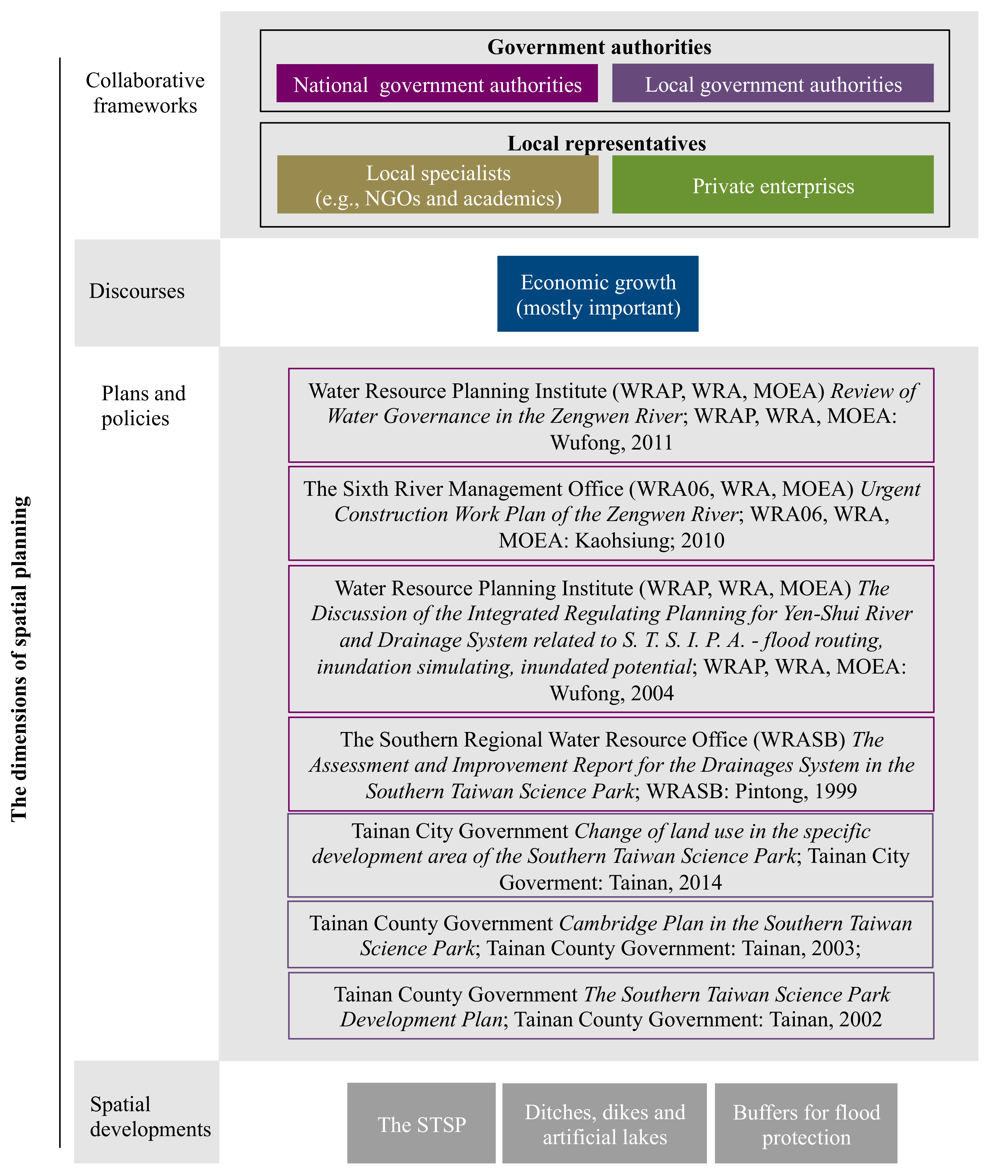
Referring to Healey’s attributes of governance performance, we develop a framework to explore how planning conforms and performs in the Taiwanese context. As shown in
Table 1, a typology of spatial planning is developed with four dimensions: (1) collaborative framework; (2) discourses; (3) plans and policies; and (4) spatial development. The first two study planning performance—the integration, collaboration and communication addressed in the process of decision-making. The other two aspects examine the conformance—the relations between plans and implementation. The mode of governance culture, i.e., the accepted modes of governance, the embedded cultural values, and the processes of critiques, is critical to all the dimensions. For example, the focus of economic development has ruined and become a rooted understanding of planning in Taiwan. It is influential on policymaking in all the dimensions.
The dimension of collaborative framework refers to the administrative structure in planning. Actors and coalitions are the key attributes. Actors with a shared interest gather to form a coalition network. By increasing their power base, their interests may be more influential in directing the process of policymaking. The reform of collaboration occurs when their interests have been achieved or newer concerns gain a focus among the policymakers. Although interest will remain in the existing site in most of the cases, the reform may cause a reshaping of the institutions and bring planning governance methods into a newer state.
The dimension of discourse explores the objectives that are generally agreed upon in the collaborative framework. It relates to a belief, idea, or shared understanding about cities of tomorrow. The culture of planning is its basis. The objectives can be a conceptual vision or a concrete requirement. Conceptual visions, such as sustainable development, remain for a longer time. Concrete requirements like regeneration projects or the control of reducing CO2 emissions, would become less influential or even disappear in policymaking if accomplished (or abandoned).
Plans and policies are the legal products of policymaking for spatial development. Spatial planning carries a broader view of plans and policies that refers to both agreements for practical implementation and rationales or reasons to shape the collaboration. Plans and policies may conflict or even contradict each other. For example, a development site may be proposed in a place which is designated for water retention if there is a lack of a proper framework of collaboration between planners and water engineers. Discourses (considering what is important) play a role in determining the priority of the plans. The less-prior strategies may be postponed and gradually disappear.
The dimension of spatial development is about what formulates in practice. Although not illustrated in Healey’s model of governance, it is critical for assessing the conformance of planning. Policies of land use control often have a clear physical task to achieve, such as building a highway for car transportation or installing a dike for flood protection. A common problem in land use planning is the actors who make the plans are not the ones responsible for implementation. Serious mismatches between plans and spatial development can arise, especially when control is executed only weakly or newer (and prior) tasks are arising. Spatial development in the context of spatial planning is less governmental. The power of the neoliberal market brings in a necessity of negotiation between the government and local stakeholders to shape the development collaboratively. For example, a conservative plan may be adjusted or eventually abandoned if the main discourse in policymaking is altered from environmental protection to development.
2.4. The Research Framework: To Explore the Performance of Planning
Figure 1 shows how we describe local governance of planning according to the four dimensions of spatial planning. Performance and conformance are both considered. However, we have a prior focus on exploring the performance in the process of policymaking that produces policies and influences the form of spatial development. Actors involved in the collaborative framework are categorised in four groups: the national government (dark purple), the local government (light purple), private enterprises (green), and local specialists such as non-governmental organisations (NGOs) and academics (brown). Planning discourses in Taiwan are mostly dominated by concerns for economic growth. Policymakers may embrace more environmental concerns, such as sustainability and resilience, within the prior focus of regional development. The information on planning conformity is addressed in plans and policies and used in spatial development. In this paper, we examine seven policy documents that directly link to the STSP development project (see
Figure 1, Plans and Policies). The national government has a general framework of science park development (discussed later in the paper). Under this framework, specific policies in the STSP show clear intentions for water resource and flood risk management. Local policies are mostly about development programmes and regulations. These are shaped as planning practices for spatial development.
The empirical analysis was based on semi-structured interviews (
Table A1 and
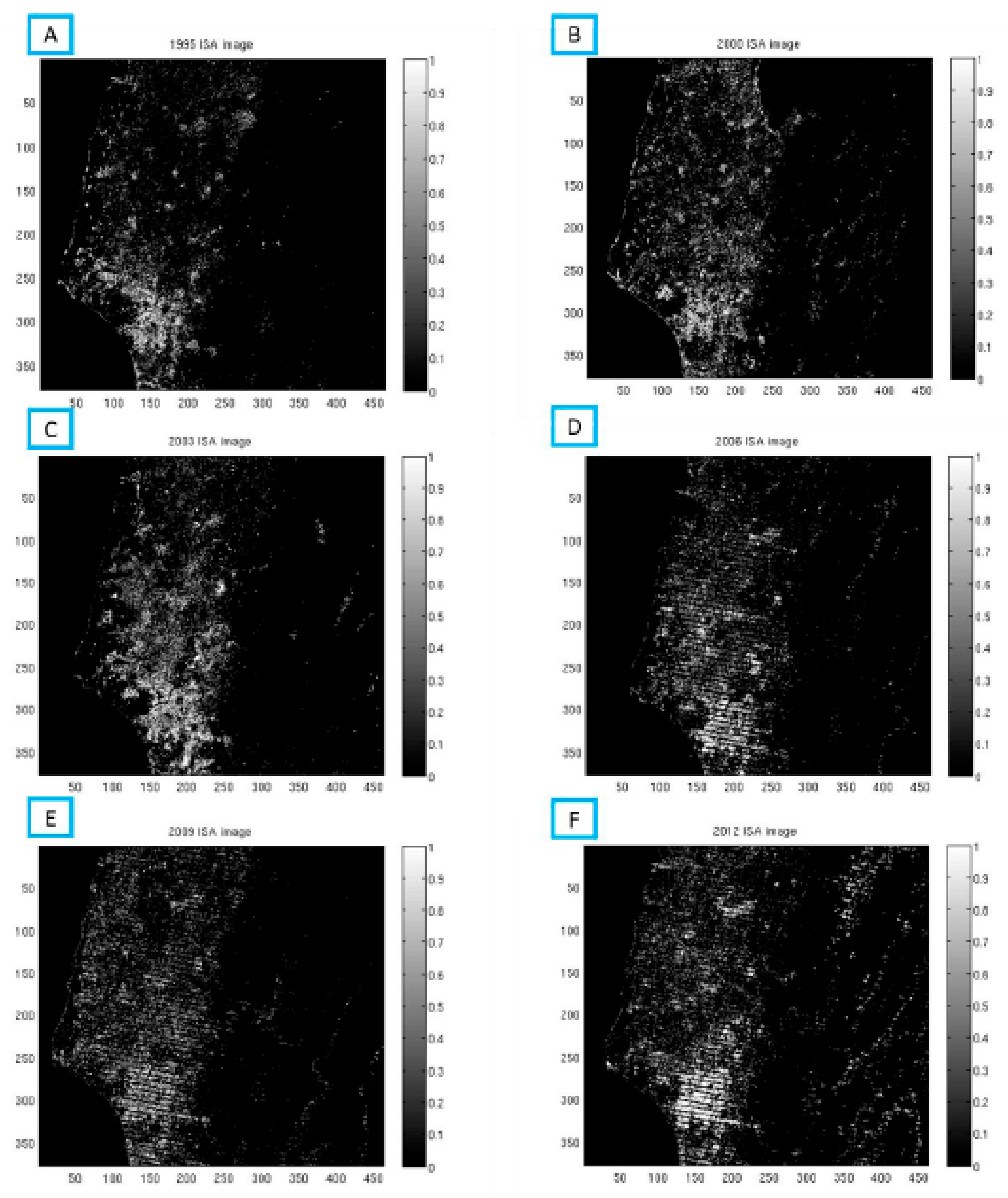
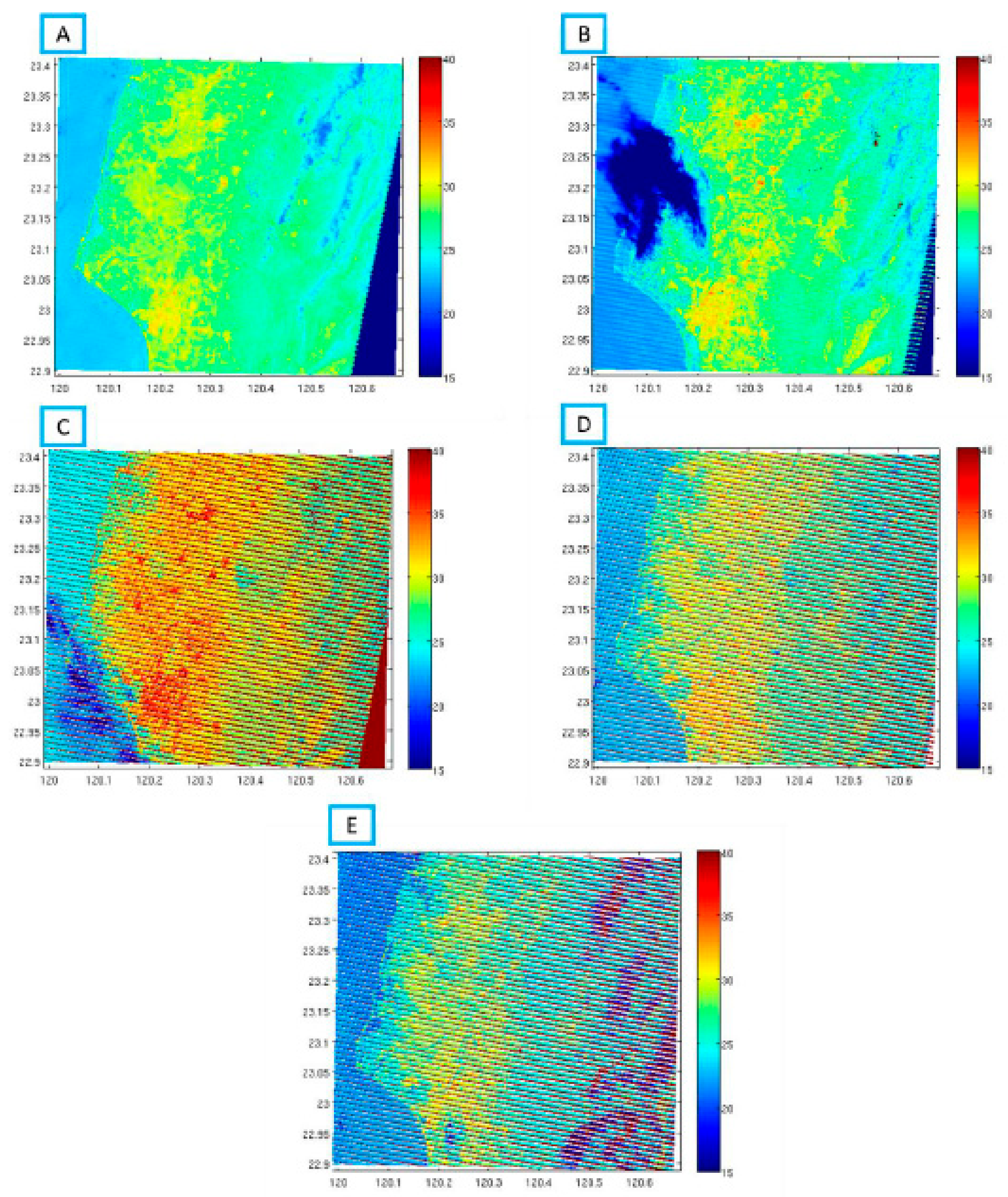
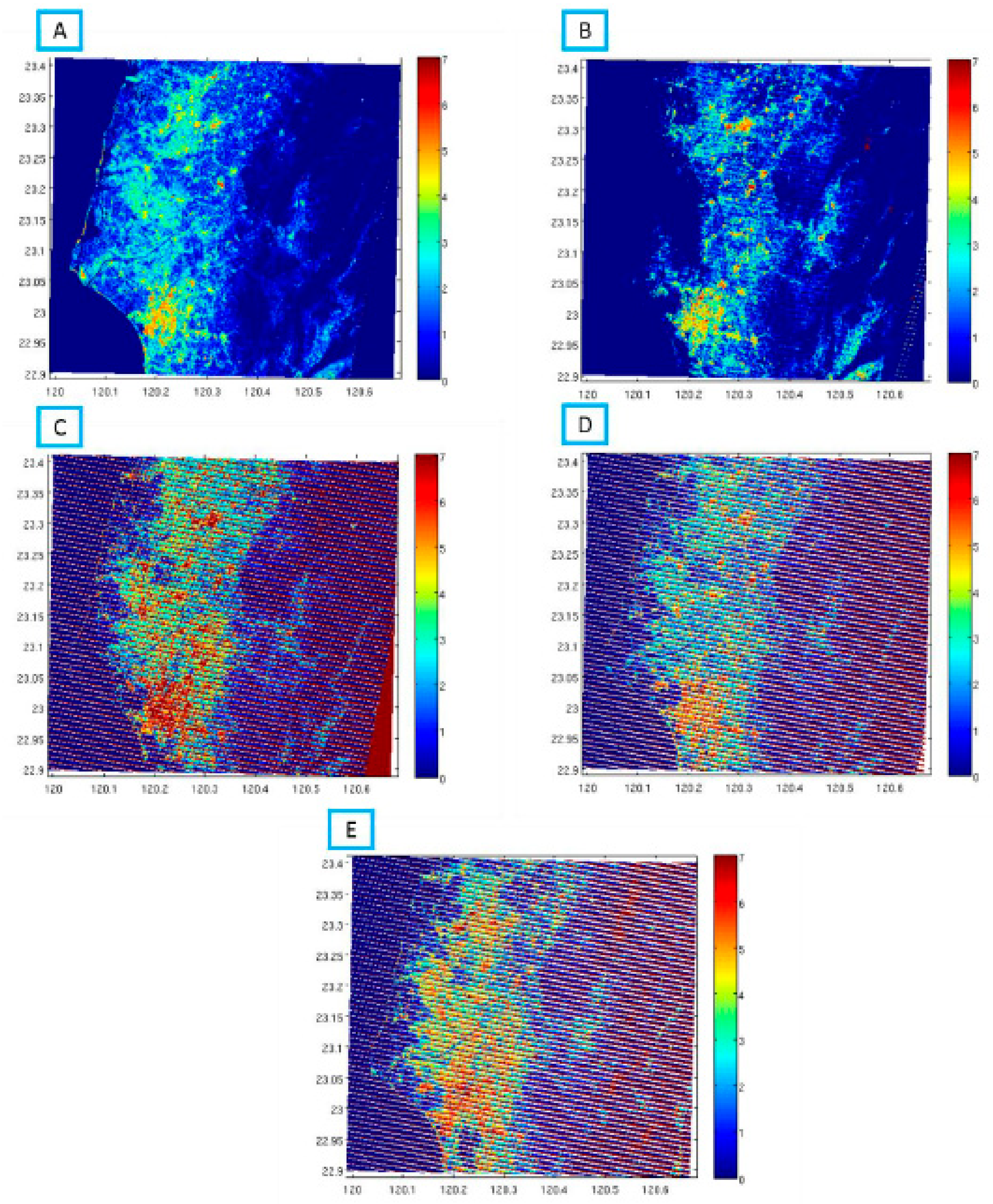
Table A2) and supplemented by a review of policy literature from 2000 onwards (see above). The interviewees included government officials deeply involved in the STSP development project and scholars who participated the urban design review. We visited the interviewees over time (2011–2017) to review the development process more comprehensively. Personal contact also continued. Planning responding to the issue of flooding mainly relies on previous experiences. Since the UHI lacks of clear events of disasters, we present it by measuring the impact of land use change (due to the science park development) on rising temperatures in this region. Landsat images provided external temporal coverage that enabled us to perform the measurements. We set up three criteria for data selection for the Landsat images. First, the time difference needed to be of at least two years to discover the underlying land use change. Second, the images had to be taken in the same season and have a similar air temperature when acquired. Third, the images were required to be relatively cloud-free (no more than 10% cloud coverage) for accuracy. Eleven images were selected accordingly from 1995 to 2012—no massive change in land use was found in this region after 2012 (
Figure A1,
Figure A2,
Figure A3 and
Figure A4). ERDAS IMAGING 9.1 and ArcGIS 9.3 were applied for data processing. Detailed planning concerns relating to flooding and the UHI are discussed in what follows.
3. The STSP: Governance and Planning Performance
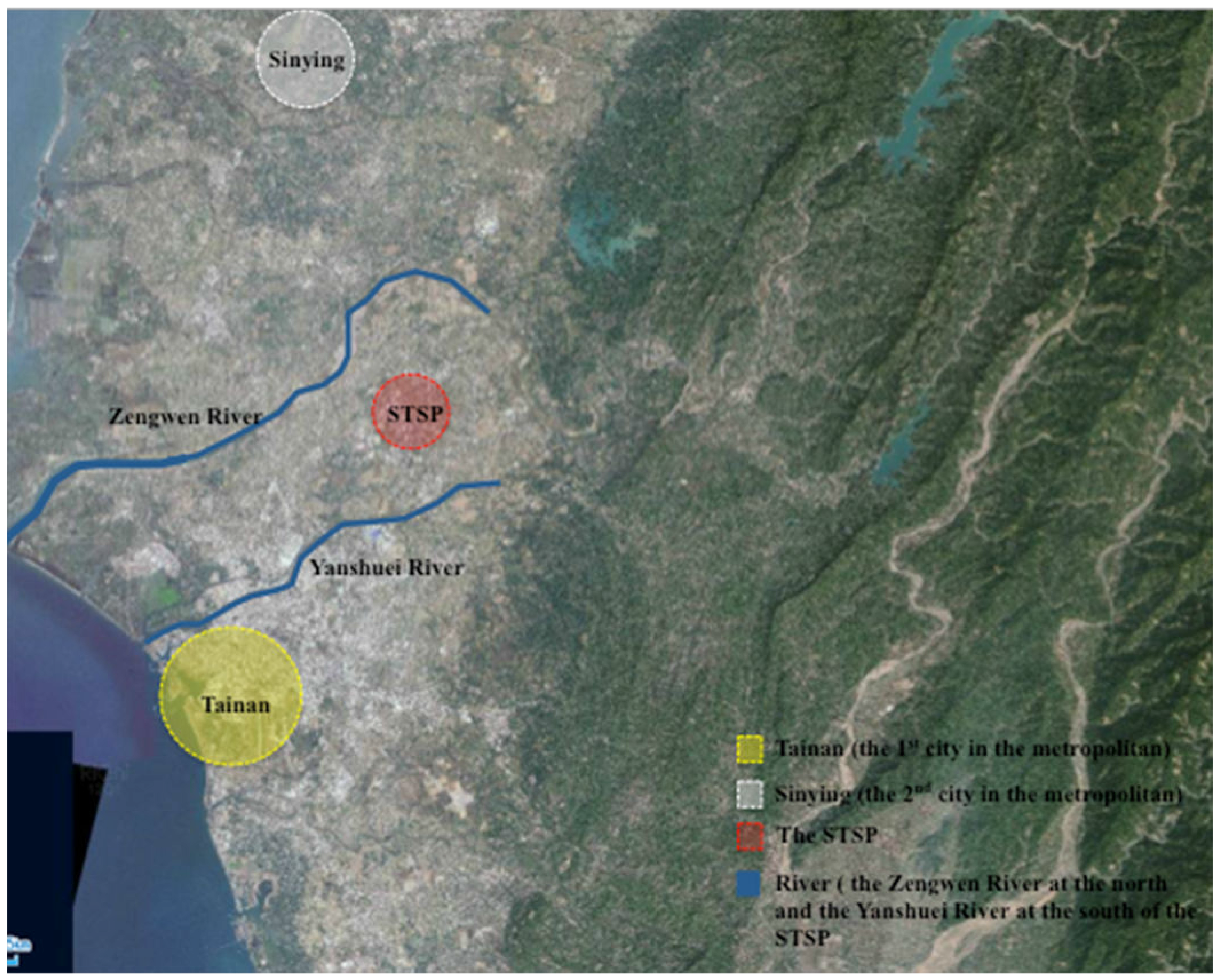
The STSP is a national-led science park development project for the high-tech industry. It has two sites. The Tainan Park (about 1000 hectares) was constructed first in around the early 1990s. The Kaohsiung Park (about 570 hectares) was formed later in the 2000s and remained in an early stage of development. This paper uses the term STSP to refer to the Tainan Park. As shown in
Figure 2, the STSP is located in the flood-prone area with the Zengwen River in the north and the Yanshuei River in the south. The development site has convenient access to transportation to Tainan, the administrative centre and the largest urbanised area of the region (yellow circle), and Sinying, the former centre of the sugar cane industry and the second-largest urbanised area (white circle). The core development area is about 400 hectares, assigned for high-tech firms and commercial and residential land use [
28,
29].
The STSP development project was proposed when the first national science park, the Hsinchu Science Park (HSP), reached its limits for further expansion. Policymakers determined the location with the political purpose of balancing regional development [
28,
30]. They expected the STSP would bring external investment to the southern area, where the regional economy was generally weaker than in the north. Both the national and the local government were actively involved. The STSP had a flood-prone location. The original agricultural land use had been limited to minimise economic loss by floods. In fact, the former proprietor, the Taiwan Sugar Corporation, was pleased to lease the land for newer development because of its poor conditions.
The peak of economic growth and the flood-prone condition brought a great need for collaboration in planning for flood risk management. At the national level, the National Science Council (NSC, renamed the Ministry of Science and Technology, MOST, in 2014), the responsible sector for national science park development, took a leading role of the development. The Council for Economic Planning and Development (CEPD, renamed the National Development Council (NDC), in 2014), the highest planning authority in Taiwan, focused on framing the development strategies. The Water Resource Agency, of the Ministry of Economic Affairs (WRA, MOEA) was responsible for coping with floods and ensuring sufficient water supply in this area. Sub-authorities involved in policymaking included: (1) the Water Resource Planning Institute (WRAP), responsible for examining flood risks and providing possible solutions; (2) the Sixth River Management Office (WRA06), focusing on engineering constructions of the rivers; and (3) the Southern Regional Water Resource Office (WRASB), working on the issues of water supply. At the local level, the Water Resource Bureau (WRB) and the Urban Development Bureau (UDB) of the original Tainan County were active in shaping the development plan. Their collaboration remained and was even strengthened after Tainan County was reformed into the City of Tainan in 2010. We identified the process of policymaking in terms of three clear intentions with respect to development.
3.1. High-Tech New Town
In Taiwan, the tradition of planning gave the national government overwhelming power to lead and affect spatial development. For example, the national government set up six Export Processing Zones (EPZs) in the 1960s, along the major ports in central and southern Taiwan to promote labour-intensive and export-oriented industries. These EPZs provided great benefits to the economy. The national government continued to initiate the “Ten Major Construction Project” in the early 1970s, which augmented basic infrastructure, e.g., railways, airports, and ports, to support regional development. Their interventions brought rapid growth to the economy during the 1980s [
31]. In the late 1970s, policymakers adopted the approach of state-led science park development and took it as the key instrument to support the development of the high-tech industry. The first science park, the HSP, was strategically conducted in the Hsinchu area where one of the most important national research institutes and two national universities were located. The national intervention in spatial development was critical. Other sectors, such as the Hsinchu local government, were passive or were even excluded from the science park development programme.
The state-led approach changed in the 1990s. The technocratic approach of planning was increasingly challenged by the force of neoliberalism in shaping spatial development and became less dominant. According to Hsu [
32], the national government became more hesitant in opposing pro-developmentalist strategies and was instead more interested in playing a supplementary role for regional development as subsidy providers. This brought in a transition in science park development from a single technopole strategy to a technopolis programme [
30,
32]. In the STSP, the local government became the major promoter facilitating the development. The original Tainan County government experienced a long period of competition with other municipalities in southern Taiwan before the national government finally determined the location of the STSP. According to the Tainan County Comprehensive Development Plan, the STSP was going to be the third major city of Tainan to conduct a polycentric structure of regional development [
28,
33].
Private enterprises were active in shaping the development. High-tech firms, especially some large firms that had been located in the HSP and sought land to expand their production capacity, were active and willing to invest. This willingness, according to the interview, was motivated by both economic and cultural considerations. The economic attraction included lower taxes, an adequate labour force, and larger space for manufacture. The cultural attraction was related to the personal links. Clusters of supply chains were therefore reformulated. The personal connections of the south became loyal to this location. “Many successful businessmen came from the south. The STSP was like a call to go back home” (Interview S4).
The STSP’s critical role in economy, as a shared agreement, resulted in collaboration for flood risk management. Engineering projects such as the construction of ditches, dikes, and artificial lakes were undertaken. Housing developers represented these infrastructures as facilities that would enhance environmental comfort and living quality [
34]. The issue of flooding was hidden in the market. About 45% of the development site was designated as a green and blue area for public land use, which from the perspective of hydraulic engineering was set up mainly for water retention [
35]. Most of the residential and commercial areas were constructed in the surroundings. Policymakers required private enterprises and developers to be responsible for raising the elevation of their properties for flood protection [
34,
35,
36,
37,
38].
3.2. Floating Zones
Policymakers introduced the floating zone policy to encourage private investment for development. It is more common today but quite an innovative strategy in the 1990s. A floating zone was a zoning district delineated as an amendment in the zoning ordinance. It remained floating until a development application was approved and was then added to the official zoning map. Instead of being placed on the zoning map as traditional zones were, this offered more room for policymakers to redistribute the development units according to the development progress. The development could thereby be more sensitive to the markets [
36].
The local government, in cooperation with the large high-tech firms, was the major promoter of the floating zone policy. According to the interview, they “put a lot of efforts to convince the NSC (MOST) and the CEPD (NDC)” (Interviews S2 and S4). This matched the discussion of local empowerment and the transformative role of the national government. However, interpreting the transformation as a replacement was hasty. The national government retained a different but still essential role, especially in environmental management. The WRA authorities remained the most critical actors in physical implementation for water management, and the NSC (MOST) was still the responsible sector and the key founder in legitimacy according to the Act for Establishment and Administration of Science Parks.
The result of implementing the floating zone policy was beneficial to spatial development as well as to flood risk management. The policy allowed the developers to initiate and to implement the development plans in phases. Smaller developers could therefore be involved and afford to participate. By conserving the original land use (mostly farmlands) before the development, the floating zone policy also helped to reduce the speed of impervious pavement increase and therefore to minimise the pressure of the drainage capacity caused by the rapid growth of the development site.
3.3. Water Resistance Buffer
The water resistance buffer was brought to attention recently after the area experienced great economic loss resulting from a severe flood. Typhoon Morakot (2009) brought extreme rainfall to this region (over three metres of heavy rains within four days). The high water level crushed the river dikes and caused a river flood. Although the core development area was protected, it was isolated as an island with no access to transportation for over a week. Economic loss from the global market was significant.
This flooding experience caused policymakers to focus more on the need for flood prevention in the surrounding areas. Both mitigation and adaptation strategies were proposed afterward [
37,
38,
39,
40]. As shown in
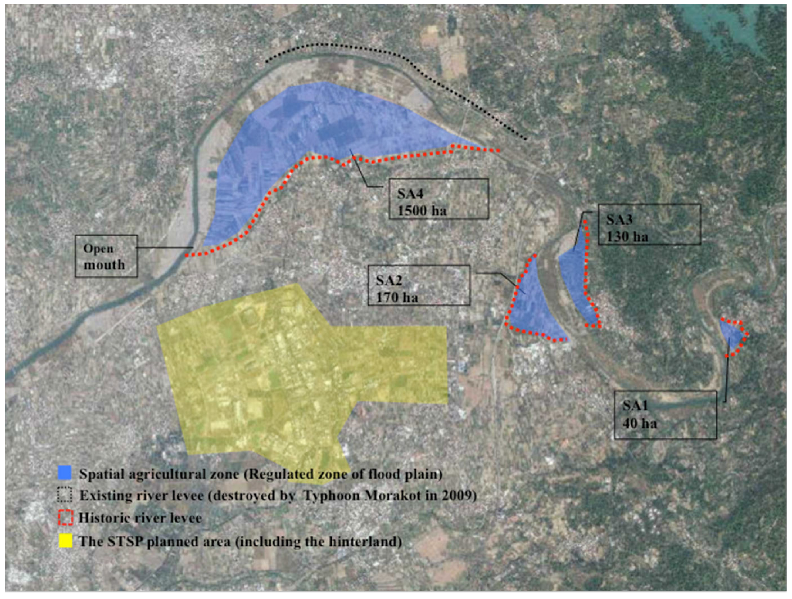
Figure 3, a water-resistant buffer was proposed along the south bank of the Zengwen River [
37]. The black dotted line indicated the river levees destroyed in 2009. The WRA06 was responsible for restoring the infrastructure. The red dotted line represents the location of the abandoned dike. The WRB intended to restore the levee as the second barrier to cope with the river floods. The blue area between the levees was the buffer of water resistance. It was expected to cope with the river floods “
as a river belly” (Interview S2) through adaptation.
The planning and hydraulic engineering sectors formulated a collaboration for practices. The implementation was almost not possible when following hydraulic engineering regulations. The National Water Law forbade the government to use private land properties for water management. This meant the government needed to buy the entire farmland and use it for water retention alone—which was “
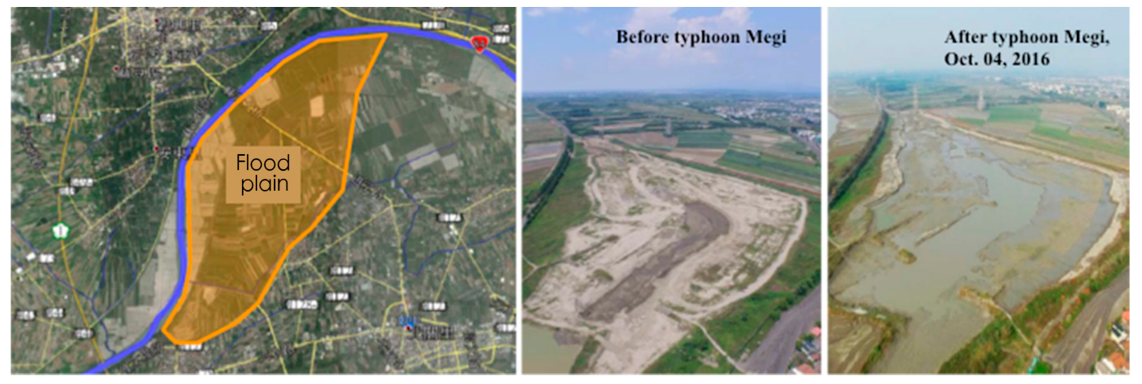
neither possible nor sufficient” (Interview S2). Planning authorities proposed a way to implement the buffer through land use regulations. The UDB revised the land use policy that designated the buffer area (the blue area) as a Special Agricultural Zone. Only lower-profit agricultural land use was permitted. Around 2000 hectares of farmlands were influenced by the regulations. Policymakers in this way enhanced the standard of flood protection in the STSP while maintaining the original functions of the land. The buffer carried the river floods in 2016 also when Typhoon Megi brought extreme rainfall to this region. As shown in
Figure 4, the buffer area carried most of the river floodwater, thereby keeping the STSP safe from the flooding event.
4. Discussion
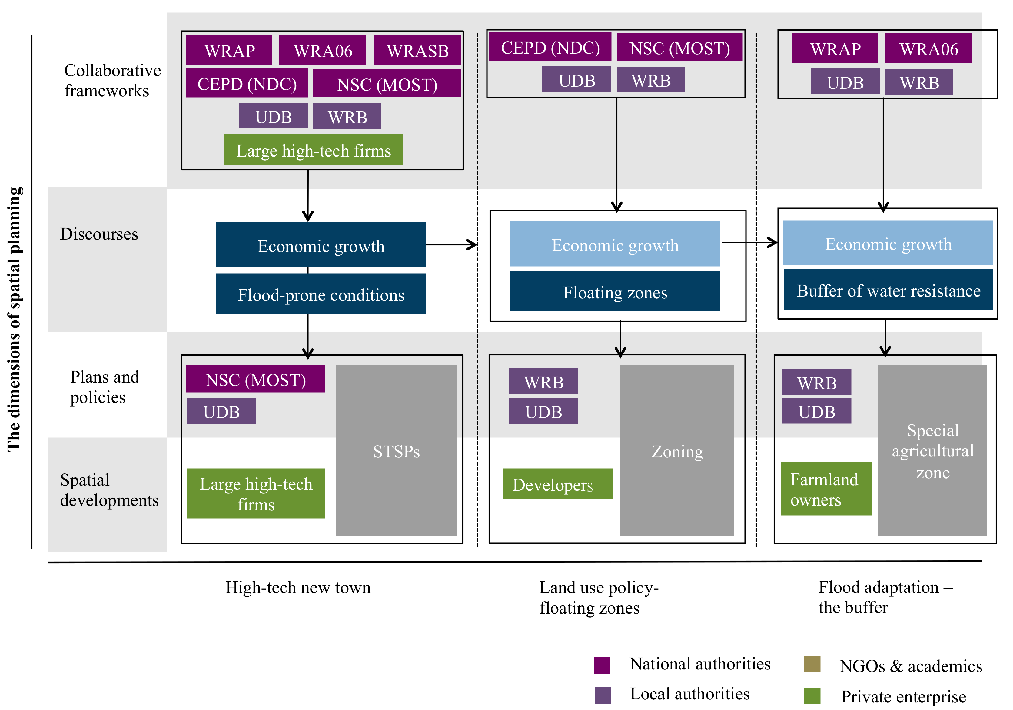
The governance of spatial development in the STSP is illustrated in
Figure 5. Actors and critical discourses (key values in spatial development) are included. Critical highlights are:
In the STSP, planning discussions directly led to planning practices. This was shown in the coherence of the vertical relations among the four dimensions.
The national government, the local government, and private enterprises were all involved in the STSP’s development. At the national level, the CEPD (NDC) and the NSC (MOST) were more interested in the issue of land use development. The WRAs mainly focused on the issue of flood prevention. At the local level, the UDB and the WRB were involved in both issues.
The local government, cooperating with large high-tech firms, took the leading role for spatial development—this is not the traditional approach to science park development. The STSP represents a transformation from a single technopole strategy to a technopolis programme [
30,
32].
The UDB–WRA collaboration played a critical role in promoting spatial development and flood risk management. The artificial lakes in the science park created a leisure environment, and the Specific Agricultural Zone defined proper land use in the flood-resistant area.
The NGOs and academics were weakly implicated in policymaking. This be a result of the fact that firstly, science park development is generally understood as a technocratic issue that requires qualified professionals to participate. Secondly, the development area was originally owned by the Taiwan Sugar Corporation, a semi-government authority. Private ownership was scarcely addressed. Thirdly, local NGOs seemed to have more interest in cultural and environmental issues, such as the conservation of historic heritage and the protection of biological habitats.
Collaboration was strengthened and became cross-sectoral after experiencing flood disturbances—not only in planning policymaking but also in policies for practices.
The key advantage to economic growth was the shared understanding in policymaking. In fact, it rationalised planning practices of urban development and flood prevention.
Both the government and the private enterprises considered the development as a success. It promoted the economic growth of the country.
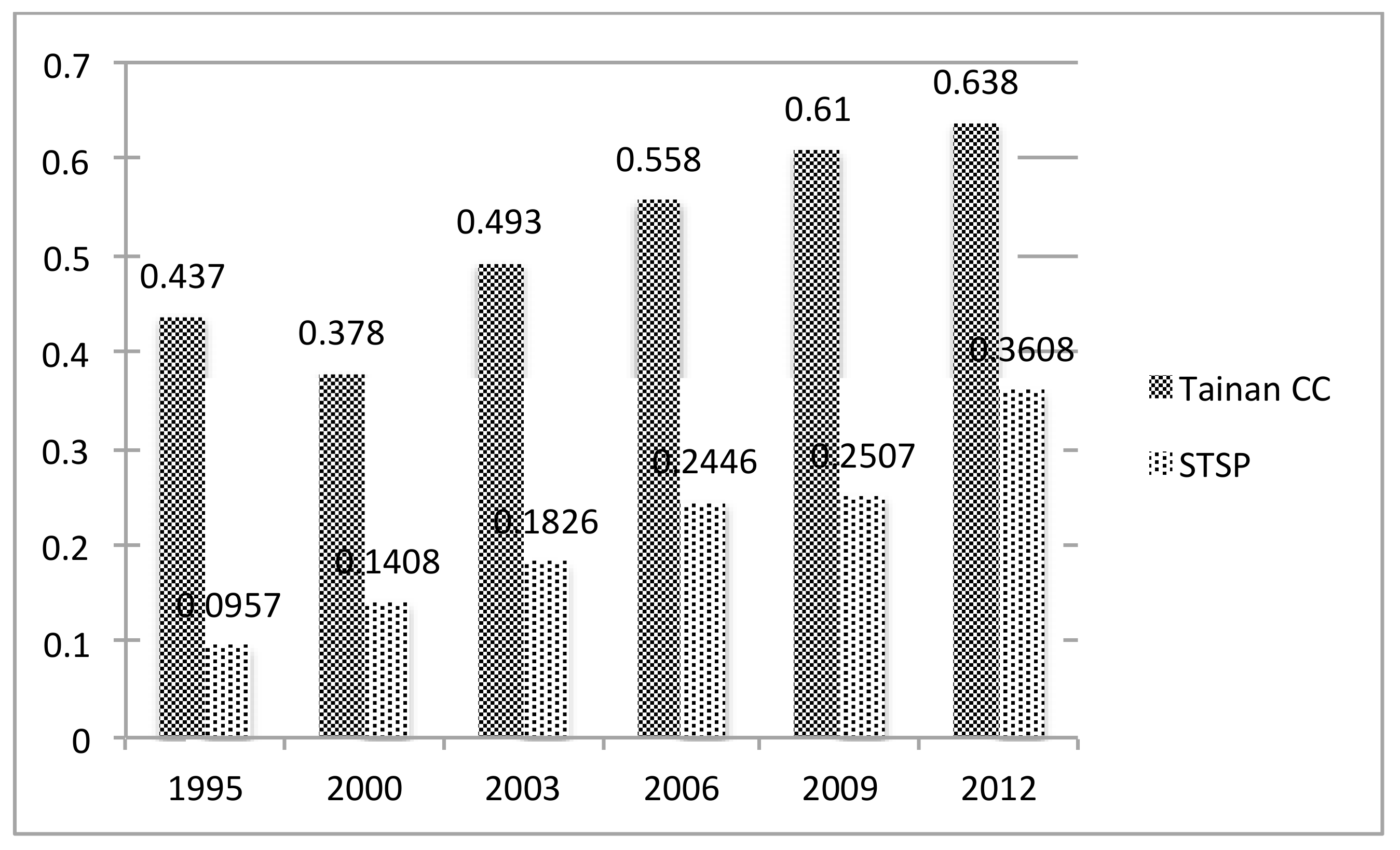
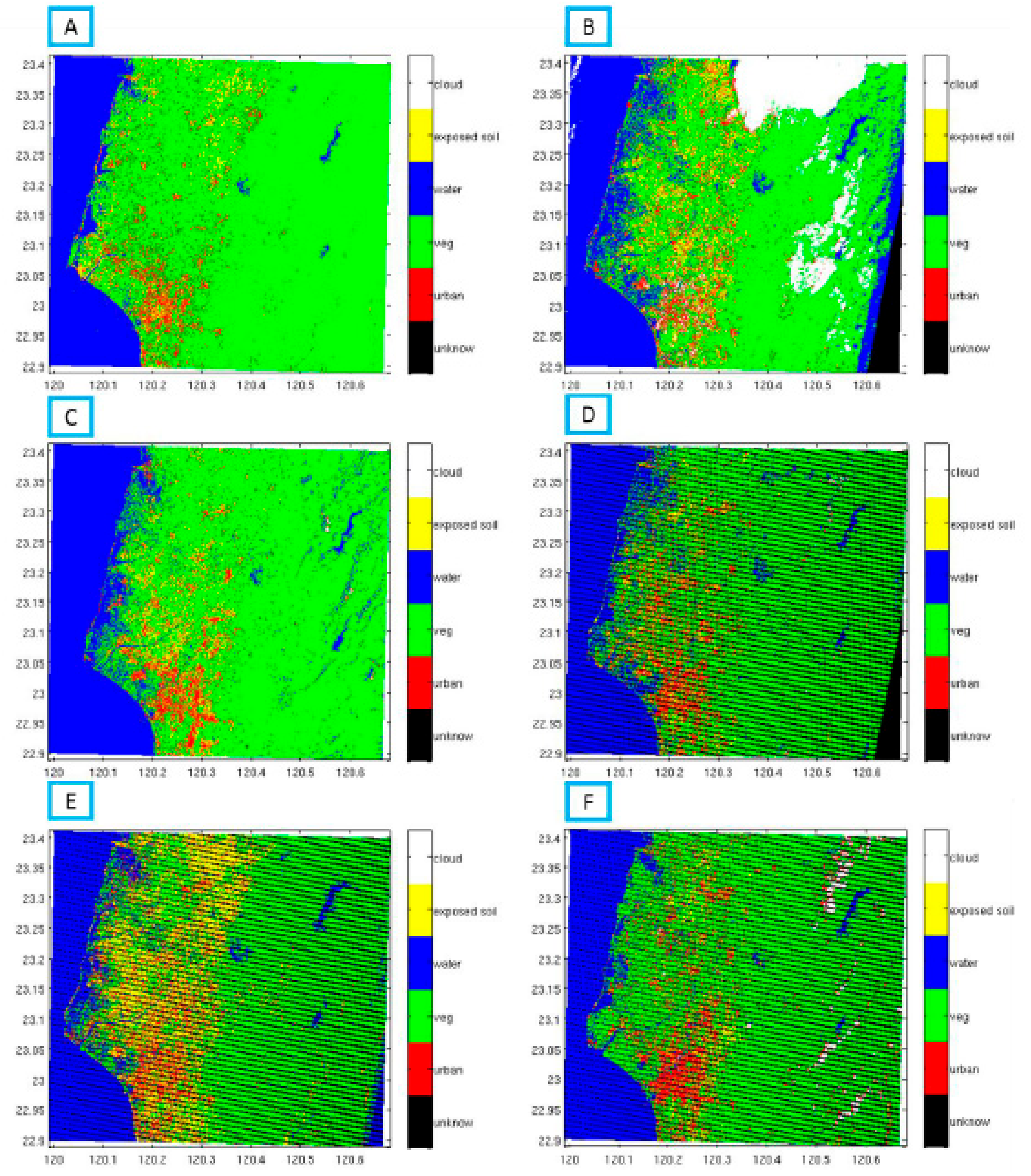
In contrast to the flooding issue highlighted in policymaking, the issue of urban heat island (UHI) was poorly considered or ignored. We saw no strategies for monitoring the rising temperature or UHI control in policy documents. The issue was also dismissed in the interviews. Calculating the UHI became a task to be performed prior to giving explanation. Temporal coverage through various Landsat images enabled us to measure the local land use change over the decades caused by the science park development, and its relation to rising temperature. The assessment had two specific locations—the STSP area and the city centre of Tainan—for comparison. Six Landsat images (1995, 2000, 2003, 2006, 2009, and 2012) were used to calculate the trends of the impervious surface area (ISA) increase in Tainan city centre and the STSP development area (
Figure A1 and
Figure A2). The results are shown in
Figure 6. Although Tainan city centre remained the most urbanised area, the STSP became the place experiencing the most rapid growth of urban extension. The ISA in the city centre increased from 0.437 in 1995 to 0.638 in 2012. The annual rate of the ISA increase was 0.0118. In the STSP, the ISA increased from 0.0957 to 0.3608. The annual rate of increase was 0.0156.
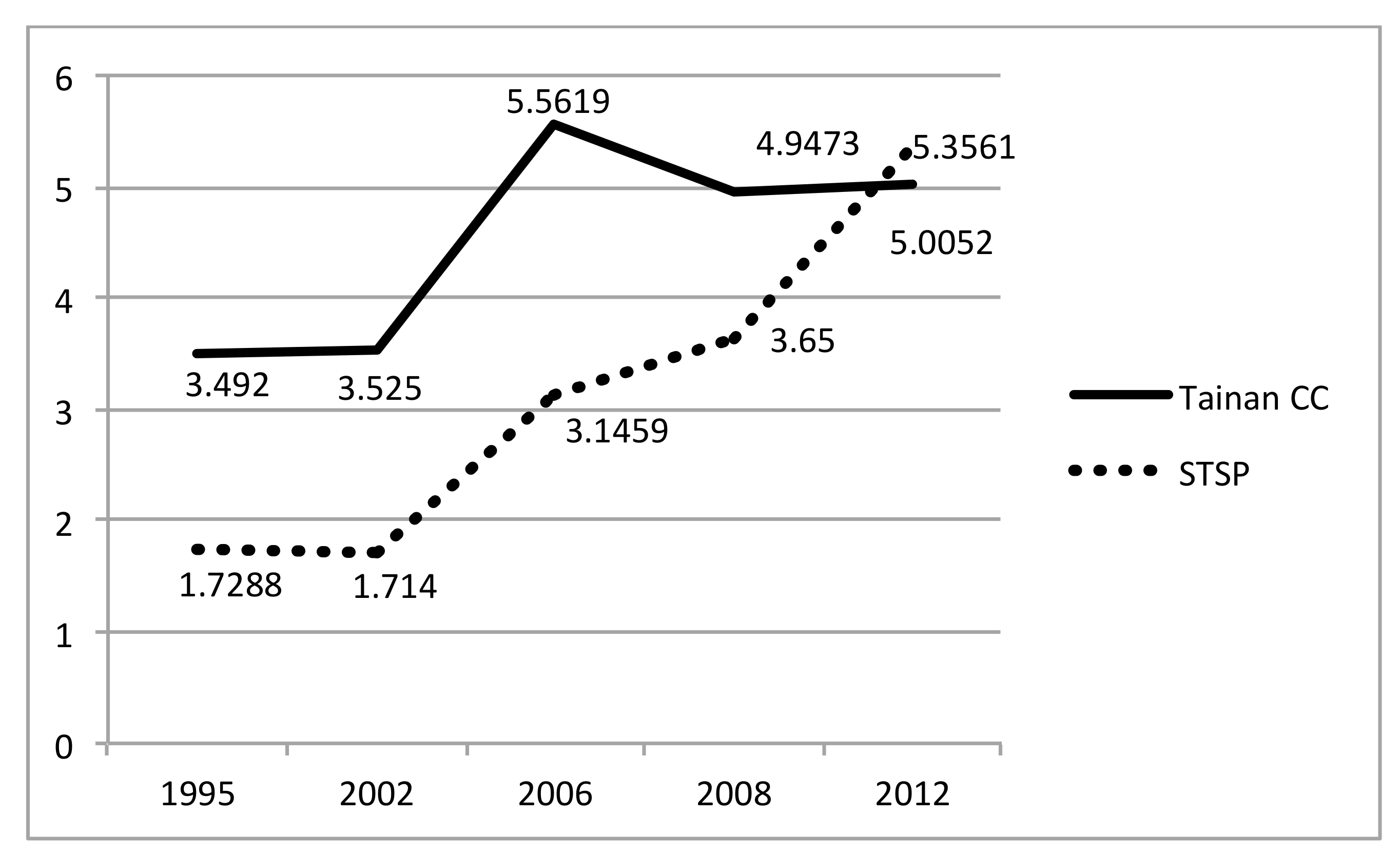
The ISA increase directly led to the increase of the UHI effect. Five Landsat images (1995, 2002, 2006, 2009, and 2012) were used to conduct temperature retrieval information for UHI calculation (
Figure A3 and
Figure A4). The result shows that the STSP experienced a greater trend of rising temperature than the city centre. As shown in
Figure 7, the UHI in the city centre was about 3.492 °C in 1995 and 5.0052 °C in 2012. The annual rate of temperature increase was 0.089 °C. In the STSP area, the UHI increased from 1.7288 °C in 1995 to 5.3561 °C in 2012. The annual rate of increase was 0.2133 °C. This is about three times higher than in the city centre. The STSP has become hotter than the city centre, according to the information from 2012.
The impact of the UHI can be severe. As a type of micro-climate change, the UHI can affect the patterns of local rainfall, e.g., by increasing thunderstorms, and the extreme rainfall can result in flooding and related disasters [
41,
42,
43,
44]. The thermal discomfort may result in higher peak electricity demands in the warm season, i.e., energy demands for cooling, which accelerates emissions of pollutants associated with power production, thereby increasing generation of ozone. The situation might be more severe if coupled with global warming.
5. Conclusions
The study explores how the neoliberal approach of planning responds to the issue of flooding and the UHI. We found that policymakers are aware of and able to manage the issue of flooding, but consideration with respect to the UHI effect is lacking. These results imply that, in the past, planning in Taiwan performed better in terms of managing flooding and relevant disasters than managing UHI and the future threats resulting from the development. Neither policy documents nor interviews show awareness in considering the impact of the UHI on spatial development—even through the trend of temperature increase here is much stronger than in the city centre.
A variety of disturbances can also shape policymaking in different ways. Disruptive disasters, e.g., flooding, can receive more interest than gradual changes, e.g., the UHI. The impact of rising temperature, changing patterns of participation, and higher risks of flooding, is not a part of what planning considers. A lack of scientific integration creates difficulties for policymakers in terms of decisions reflecting trends and future conditions. Rather, they rely on previous experiences of disturbances for future preparations. This matches Lu´s study [
12] that points out the dependence on lessons learned from previous losses and ignorance with respect to potential risks resulting from forms of land use today. The potential risks are oversimplified or ignored by actors involved in contemporary planning policymaking. Neither the government authorities nor the private enterprises show an awareness of the environmental cost. Although the transition of governance power has made the STSP a localised technopolis, this presents no differences in this regard.
How well does planning contribute to promote urban resilience? The study results in a fact that the cost (the consequence of spatial development) is as crucial as, or even more important than, the risk—while is often underestimated in this neoliberal approach of planning policymaking. We do not think there is a particular form of spatial planning that can be distinguished as “resilience oriented spatial planning.” However, we believe cross-actoral collaboration, the essence of spatial planning, is a key to promote a city becoming more resilience.


