Article

Understanding Driving Forces and Implications Associated with the Land Use and Land Cover Changes in Portugal

1
Centre for Geographical Studies, Institute of Geography and Spatial Planning, Universidade de Lisboa, Edif. IGOT, Rua Branca Edmée Marques, 1600-276 Lisboa, Portugal
2
General Directorate for Territorial Development (DGT), Rua da Artilharia Um, 107, 1099-052 Lisboa, Portugal
*
Author to whom correspondence should be addressed.
Sustainability 2017, 9(3), 351; https://doi.org/10.3390/su9030351
Submission received: 28 December 2016 / Revised: 9 February 2017 / Accepted: 21 February 2017 / Published: 27 February 2017
(This article belongs to the Section Environmental Sustainability and Applications)

Abstract

:
Understanding the processes of land use and land cover changes (LUCC) and the associated driving forces is important for achieving sustainable development. This paper presents the LUCC in Portugal at the regional level (NUTS II) from 1995 to 2010 and discusses the main driving forces and implications associated with these LUCC. The main objectives of this work are: (a) to quantify the land use and land cover (LUC) types (level I of LUC cartography) by NUT II in Portugal for the years 1995, 2007 and 2010; (b) to assess the spatio-temporal LUCC; and (c) to identify and discuss the main driving forces of LUCC and corresponding implications based on correlations and Principal Components Analysis. The results revealed large regional and temporal LUCC and further highlighted the different and sometimes opposite time trends between neighboring regions. By associating driving forces to LUCC, different influences at the regional level were observed, namely LUCC into agriculture land derived from the construction of dams (Alentejo region), or the conversion of coniferous forest into eucalypt forest (Centre region) associated with increased gross value added (GVA) and employment in industry and forestry. Temporal differentiation was also observed, particularly in the settlements that expanded between 1995 and 2007 due to the construction of large infrastructures (e.g., highways, industrial complexes, or buildings), which is reflected on employment in industry and construction and respective GVA. However, certain LUCC have implications, particularly in energy consumption, for which different behavior between regions can be highlighted in this analysis, but also on land-use sustainability.

Graphical Abstract

1. Introduction

The land use and land cover (LUC) of territories is changing and these transitions have influences in the landscape [1,2,3,4]. The evaluation of these changes, both spatially and temporally, is increasingly important in the context of the sustainable use of the territories [5]. The evaluations of land use intensity and also the land use and land cover changes (LUCC) with environmental, economic and social impacts are particularly important in this context [6,7,8].
Methods for the preparation of land cover mapping have evolved, in particular, the methods of data retrieval by remote sensing (supervised or unsupervised analyses) that fostered the proliferation of studies about LUCC in different territories and scales [1,9,10,11,12,13,14].
Landscape changes have been evaluated around the world by different authors (e.g., [15,16,17,18,19,20,21,22]), using different models and tools (e.g., artificial neural network, Conversion of Land Use and its Effects at Small regional extent—CLUE-S, Dinamica EGO, Cellular Automata (CA) MARKOV, Land Change Modeler-IDRISI, Cellular automata, Multi-Agent Systems, Spatial autocorrelation, GWR, etc.) and different geographic datasets (thematic maps, satellite images, institutional LUC cartography at different scales, among others).
Deforestation is currently a major problem due to its large effect on the reduction of air and water quality and climate changes [23,24]. These LUCC have indirect influence on the environment and contribute to the reduction of the quality of life, and further affect all living beings that depend on specific life conditions in the territories subject to these LUCC. In some countries, forest land has been turned into agriculture land [25,26,27,28]. In order to maximize the agricultural production, some soils are being intensively exploited through the use of machinery and agrochemicals [29,30,31,32]. However, the intense use of these soils generates negative impacts that contribute to the physiochemical and biological degradation of them [33], some of which are currently undergoing desertification process.
Another current issue is the high artificialization of soils [12], mainly explained by the urban expansion process [34,35,36,37,38,39] that include the construction of roads, telecommunications infrastructures or urban facilities [4]. Soil sealing reduces the infiltration of rain water into the soil [40,41] and consequently the runoff increases, often causing floods, loss of human lives and material damage.
There are several research studies involving LUCC assessments that aim to identify the driving forces (e.g., [3,22,42]) and studies about the impacts on the environment, economy and society, and its influence on the development of the territories [11,43,44,45].
The driving forces of land changes have been categorized into different types, such as economic, cultural, social, political, and, in some cases, may include two or more categories simultaneously [13,46,47,48]. However, the changing patterns can be the result of a complex interaction between different driving forces at different scales of action and LUC [49]. The proven relationships between the LUC and economic variables have been analyzed and explained in detail [50,51]. It is also important to consider the temporal component of the driving forces in this analysis [46] in order to understand if these have the same influence on LUCC over time, but also to figure out if these temporal variations are similar (among regions).
Landscape changes that occurred in the last decades in Portugal have been evaluated in some parts of the territory and in different contexts, such as the LUCC estimation in the LANDYN Project [52], in the reporting of emissions and carbon sequestration in the LUC sector and in governmental reports [4], and other publications revealing clear evidence of LUCC [52,53,54,55,56]. These studies show that the great landscape transitions that occurred in the last decades in Portugal, derived largely from LUCC along the coastal areas with the increase of land artificialization and reduction of forest land due to forest fires and anthropic actions [28].
The evaluation of LUCC is crucial for landscape changes assessments and evaluation of territorial dynamics, as well as for the implementation of new investments, policy development (sustainability development) [37] and spatial planning actions among others. However, the assessment of landscape changes that quantifies the full spatial variations to allow regional differentiation, as well as the temporal variations to identify the main driving forces, has not yet been made in Portugal.
The identification of driving forces associated with LUCC has been done in different locations and in different contexts in Portugal, e.g., LANDYN Project, detecting the relationship between LUCC and the resulting impacts on natural resources, such as water [3,57]. On the other hand, these studies do not address the identification of the relationships between LUCC and socio-economic disturbances in land-use planning. This topic has already been studied by other researchers albeit in other study areas [19,35,58,59].
In this context, the current research has the following objectives: (a) to quantify the LUC types (level I of LUC cartography) by NUT II in Portugal for the years 1995, 2007 and 2010; (b) to assess the spatio-temporal changes (LUCC); and (c) to identify and discuss the main driving forces of LUCC and corresponding implications (socio economic and environment factors).

2. Study Area

The study area is Portugal (only Continental Portugal, 88,962.50 km2), a European country divided into five NUTS II (Nomenclature of Territorial Units for Statistics, level II): North, Centre, Lisbon, Alentejo and Algarve.
The relief in Portugal is quite irregular, characterized by deep incised valleys surrounded by mountains in the North and by lower less rugged relief in the South. The climate is strongly influenced by the Atlantic Ocean and the Mediterranean Sea, performing the transition between the Mediterranean and the Atlantic climatic conditions. The rainfall regime is characterized by high spatial and inter-seasonal variability. The mean annual precipitation (MAP) ranges from less than 500 mm, in the south and northeast, to more than 2000 mm, in the northwest. The spatial variation of MAP reflects the influence of latitude, elevation and distance to the ocean. In fact, MAP tends to increase with increasing latitude, elevation and proximity to the Atlantic. Summer months (June, July and August) are particularly dry and the rainfall concentrates, mainly, in the period lasting from October to March.
The population is concentrated along the coast, especially in the metropolitan areas of Lisbon and Oporto. In recent years, some cities in the countryside have expanded towards the periphery (e.g., Viseu in Centre region), but rural areas still prevail. Some urban macrocephaly can be found in the study area which resulted from the concentration of activities and population that once migrated towards the large urban centers and settled there (rural exodus) [60].
In Portugal, there are large spatial contrasts in terms of LUC (Figure 1), within the NUTS II coinciding with large spatial variations of LUC for the years 1995, 2007 and 2010 (Table 1).
Forest land and others LUC occupy more than 65% of the LUC of the country showing different spatial distributions. The Northern region is dominated by pinewoods (Pinus pinaster), rain-fed crops and shrub land, whereas, in the Centre region, these types of occupation are also dominant but there is a higher percentage of land occupation with Eucalyptus, which differentiates the forest species in comparison to the Northern region. The LUC of the Lisbon Region is dominated by rain-fed crops and settlements. In Alentejo, the forest is totally differentiated from the previous regions with predominance of evergreen oaks (Quercus suber and Quercus rotundifolia), rain-fed crops, and even with high percentage of grassland. Shrub land is predominant in Algarve and this region is also characterized by the dominance of Quercus suber in forest areas (Figure 2).

3. Data and Methods

Figure 3 presents the methodological scheme used in the LUC cartography, LUC type variations, spatio-temporal LUCC, driving forces and implications assessments.

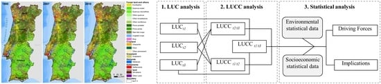
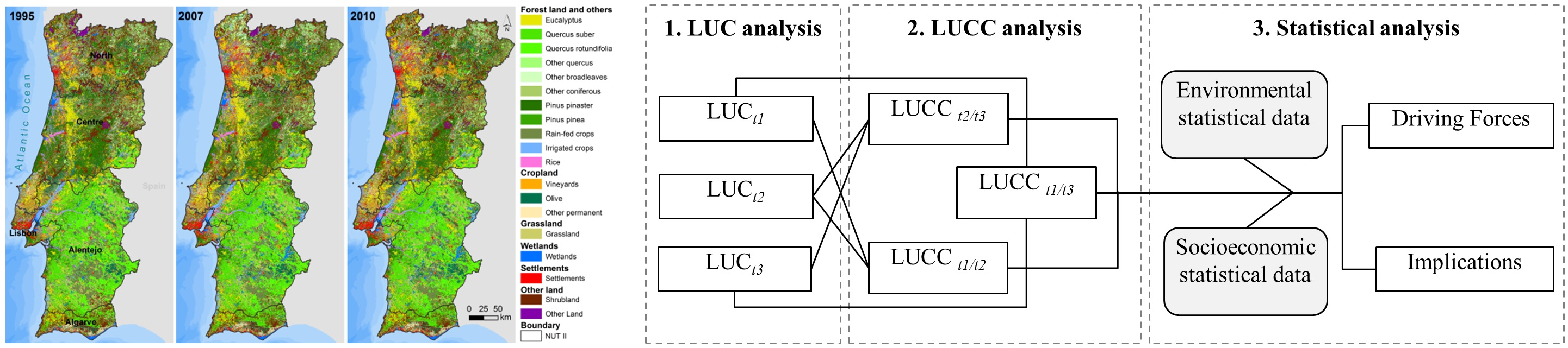
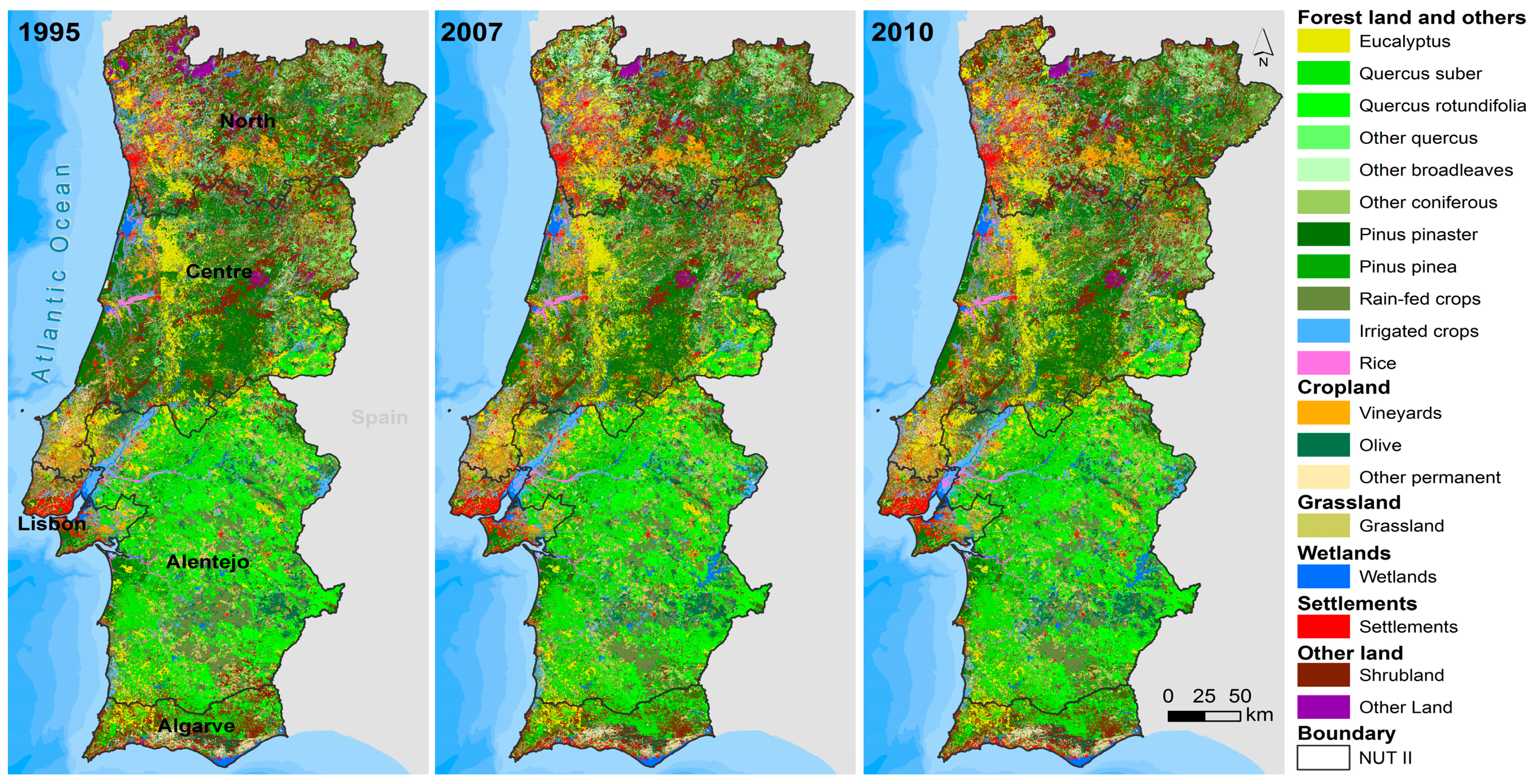
3.1. LUC Cartography

The LUC data used in the evaluation of the LUCC of Portugal are derived from Land Cover Maps of Portugal for the years 1995, 2007 and 2010 produced by the General Directorate for Territorial Development (DGT), using a nomenclature (hierarchical) defined to support Kyoto reporting of emissions and carbon sequestration in Portugal [4]. The LUC data have the following characteristics: scale 1/25,000; 1 ha of minimum mapping unit; vectorial data model (polygons); and minimum distance of 20 m between lines. These are the most recent LUC data with higher cartographic detail for the complete study area. The cartographic information of 2007 was obtained from photointerpretation of orthophotos (0.5 × 0.5 m), a process aided by IRS and AWIFS satellite imagery and geographic information of cadastral surveys (agriculture and forestry) done at DGT. All results were validated (geometrically and thematically) in order to obtain data with high accuracy and quality [61]. The DGT used for the LLUC cartography of 2010 the same methodology used for the cartography of 2007. The LUC cartography of 1995, also produced by DGT, was obtained using the vectorial data of LUC boundaries of 2007 that were updated to the 1995 LUC, based on orthophotos and satellite images of this year.
In the present work, the LUC cartography for the year 1995 is only available with the nomenclature used in the Kyoto report. For this reason, and in order to allow LUC comparison between different periods, the legend of the LUC maps of 2007 and 2010 follows the nomenclature used in the Kyoto report.
LUC maps were created for the years 1995, 2007 and 2010, followed by the assessment of losses and gains of area by LUC type between the different years. LUC types include the level I, corresponding to the principal LUC (forest land and others, cropland, grassland, wetlands, settlements and other land), disaggregated into level II (Table 1).
LUC cartography of Portugal with similar characteristics was available only for those years that have conditioned the choice of LUCC analysis periods: the first period comprises 12 years, and the last three years. This can influence the presented results, especially when comparisons are made between the two periods, regarding LUCC, driving forces and implications. We have opted for the in-depth analysis of the relative variations calculated for each period.

3.2. LUC Type Variations

The variance between main groups of LUC types (corresponding at level I of LUC cartography) that differ from the average is obtained by the following coefficient of variation:
L c v = ( σ A ¯ ) × 100 %
where Lcv is the coefficient of area variation of the LUC group i in a time series, σ is the standard deviation area of the classes (level II) that integrated the group of LUC (level I) and A ¯ the mean area of these classes (level II).
The measure of relative dispersion, Lcv, is used to evaluate and compare different distributions of LUC areas, i.e., the variability of the areas relative to the mean. Small values of Lcv are related to more homogeneous data sets (in this case, areas of the LUC types—level II—that integrated the principal LUC class corresponding to level I). Temporal changes in area by LUC type were obtained using the following equations [44]:
A k = A t 2 A t 1
A k r = A t 2 A t 1 A t 1 × 100 %
where Ak is the absolute variation area of the determined LUC type for the period k, At1 is the area in the initial period, At2 is the area in the final period and AKr refers to the relative variation area of determined LUC type for the period k.
The quantification of LUC is an innovation to the DGT data because there is a lack of comparisons at the national level (level I) made with the LUC nomenclature using the Kyoto report [4]. Furthermore, the coefficient of area variation (Lcv) is original as there are no comparisons between the LUC groups for the three periods under analysis.

3.3. Spatio-Temporal LUCC

To further understand the dynamics of transition between the various types of LUC, the thematic maps (Figure 2) (vector data) of the different years were crossed. The analysis of LUCC is supported by transfer matrices [62,63]:
A i j = | A 11   A 12     A 1 n A 21   A 22     A 2 n         A n 1   A n 2     A n n |
where Aij refers to the changed area from the i LUC type for period k to the j LUC type for the period k + 1, and n is the number of LUC types.
Using the transfer matrix the kappa coefficient is also calculated [64] to assess the spatial agreement of all the LUC products of the different years, using the following equation:
K = N i = 1 m P l i i = 1 m ( P p i × P l i ) N 2 i = 1 m ( P p i × P l i )
where K is the Kappa coefficient, N is the total area, and Ppi and Pli are the areas in the row and rank, respectively, of a given LUC type.
The results of the variations by LUC type (areas) were correlated among the NUTS II. This procedure is intended to find relationships between the LUCC of different periods obtained from the data previously submitted and to determine if there are regional differences in the LUCC in the study area.

3.4. Driving Forces and Implications

Statistical data (socioeconomic and environmental) collected from the databases available on the web of the National Statistics Institute of Portugal (INE), National System of Hydrological Resources (SNIRH) and Pordata (Table S1 in Supplementary Materials) for the correspondent years of LUC data were used for the analysis of the driving forces and implications associated to LUCC. This analysis is primarily based on the identification of correlations between all collected data (see Supplementary Materials, Table S1) with the previously determined LUCC. Only the variables presented in Table 2 (driving forces and implications) were considered in the study because these are the ones that have the higher correlation with the LUCC (calculated previously) determined for different regions of Portugal.
The information about subsidies and agro-environmental measures was also considered when selecting the variables driving forces and implications. However, these data are not available for the entire period under analysis.
A multivariate exploratory technique, the Principal Components Analysis (PCA), was performed using the software Statistica 7 (Stat Soft. Inc., Tulsa, USA) to develop the exploratory analysis of socio-economic and environmental standardized data with the LUCC. When performing this analysis for each type of LUC, only the variables that had a high correlation with LUCC were selected. Redundant variables were excluded from this analysis.
In recent decades, there were significant changes in areas occupied by water bodies [28], especially in the Alentejo, due to the construction of the Alqueva dam. Therefore, the volumes stored by watershed (VSW) were also considered, to find relationships with changes in area of irrigated crops or other LUC that need water. The VSW were analyzed separately with the LUCC, because the Lisbon region (NUTS) does not have any reservoirs or water storage. The watersheds were grouped according to their location in each NUTS and the average of all watersheds was considered for two years (year of LUC cartography and the previous one).

4. Results

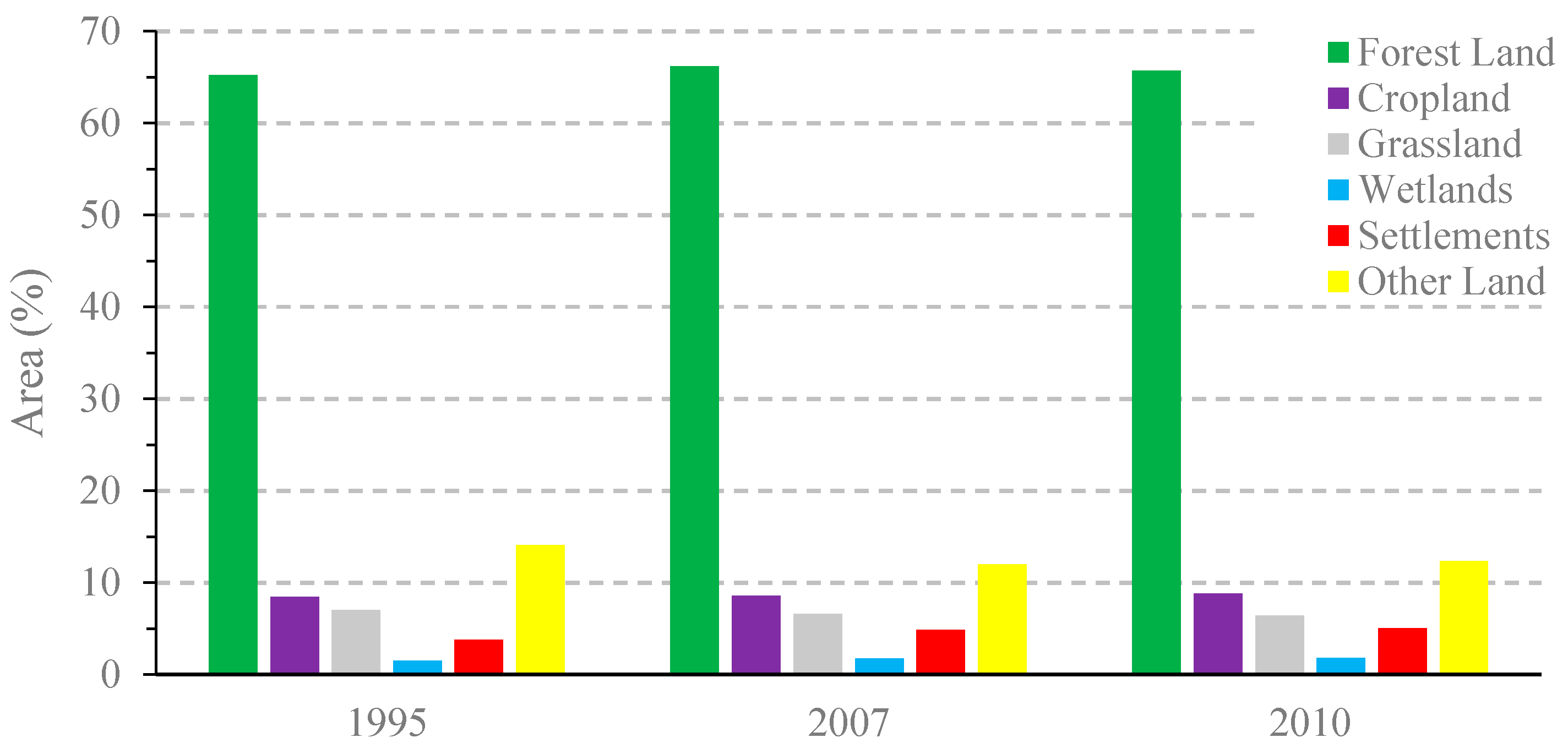
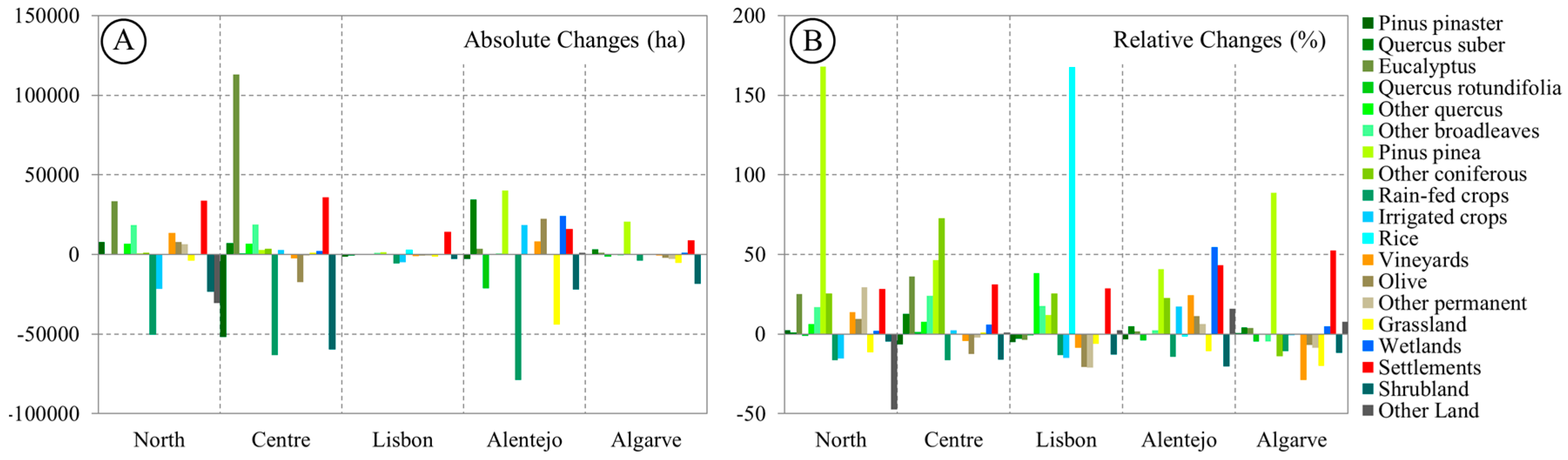
4.1. Land Use/Cover Types Variations

The LUC suffered wide changes and transitions between 1995 and 2010. According to Figure 4, the settlements distribution show that, on average, the deviations from the mean value of the areas of all the LUC classes reached approximately 14.5% of the settlements. The wetlands distribution reaches 10%, decreasing to 1% in the last distribution (forest land). It should be noted that intermediate changes in the classes that integrated each principal group of LUC (level I) can occur during this analysis, i.e., certain LUC classes (level II) can reduce their area and increase it later or vice versa, which requires a more detailed analysis of LUCC. These results are innovative and important to understand the LUCC in this territory.
The class of settlements increased during the overall period under analysis owing, largely, to the urban sprawl of metropolitan areas (Lisbon and Oporto). However, the heaviest urbanization of soils occurred along the coastal areas [65], mainly in the North, Lisbon and Algarve. Major investments in road construction throughout the country were made during this period. This generalized artificialization of land is reflected in the results of the settlements coefficients of variation (Lcv) shown in Figure 4 (each group corresponding to level I of LUC, see bold legend in LUC maps).
The wetlands class also increased between 1995 and 2010, which is explained by a large increase in the construction of new dams or reservoirs for the use of surface water for energy production and for the supply of the populations and their activities (agricultural and industrial). The infrastructure with the largest contribution to the increase in the area occupied by wetlands was the Alqueva dam (Alentejo) that comprises a reservoir of about 250 km2. However, in some cases, new infrastructures that were built around these new water bodies resulted in landscape fragmentation. This process of landscape fragmentation in wetlands has been investigated in different locations, because of its implications on the degradation of its ecological functions [64].
The other land class presented a Lcv very close to the wetlands (Figure 4). This class includes shrub land and other types of LUC. However, the first type of occupation can evolve into forest or can be lost due to the occurrence of forest fires, which are very frequent in Portugal [24,66,67]. This class ranges approximately 9% in the Lcv. The smallest coefficients of variation of LUC were observed in cropland and forest areas. Lcv results show that large variations of LUC occurred in the settlements group, in relation to the area occupied by these types of LUC in the year 1995.
The LUC transitions shown in Tables S2–S4 presented in the Supplementary Materials, registered a Kappa coefficient above 81% for the different periods under analysis (Table 3) and a high percentages of overall unchanged LUC areas. In the complete period between 1995 and 2010 overall changes reached 16.6%.

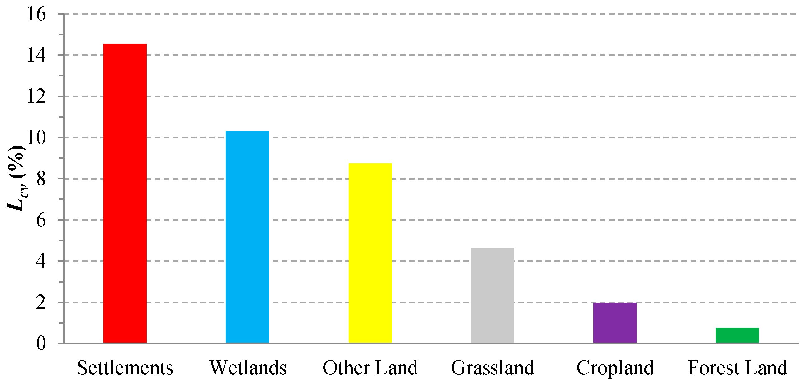
4.2. Spatio-Temporal Transitions

In Portugal, there are large spatial contrasts in terms of LUC (Figure 2). For the years 1995, 2007 and 2010 (Table 1), the largest spatial variations of LUC are visible at the NUTS II level of analysis.
LUCC analysis was differentiated in absolute (ha) and relative (%) terms in order to understand the landscape changes of each Portuguese region (Figure 5) between 1995 and 2010. Regarding the absolute variations (Figure 5A), the most important change is the loss of forest in the Centre of Portugal. The forest land area in relative terms does not present significant variations in the country, although this result does not reflect the internal transitions that occurred in this main LUC type.
A sharp reduction of Pinus pinaster and shrub land can also be observed in Central. The reduction of Pinus pinaster forests and Pinus pinea is due to the transition to Eucalyptus, shrub land, settlements, other broadleaves and rain-fed crops is the most important (see Table S4 in the Supplementary Materials). This LUC type has been affected by forest fires [24] fueled by the presence of a high number of resinous trees, forest maintenance and lack of shrub land cleaning. Forest fires cause major changes in the landscape, have destroyed a large part of the Portuguese forests [24,68,69] and the recovery of burned areas (pine forest) is very slow when the natural vegetation is regenerated without human intervention. The LUCC in Portugal are not unique within the larger picture of European LUCC, for example the reduction of pine forest in Catalonia (NE Spain) also caused by several forest fires [70].
Figure 5A shows that in the North and Centre regions there has been a large increase in the area occupied by Eucalyptus, settlements, and a reduction in the area of rain-fed crops. The significant transition of Pinus pinaster into Eucalyptus is explained by the investments in this type of forest to meet the demand of raw material for the cellulose industry [71]. Eucalyptus is a fast-growing tree that allows several cuts in shorter time-periods, thus ensuring a higher yield for the producer. Furthermore, the high incidence of pinewood nematode vector in the region of Alentejo (coast) and in the Centre region was responsible for heavy losses of pine trees [72].
In relative terms, the variations of the different LUC types by NUTS II between 1995 and 2010 are very different, as shown in Figure 5B. In the North and in the Algarve, there was a high increase in the areas occupied by Pinus Pinea (175% and 85%, respectively), while in the Centre there was an increase in the areas taken by other coniferous (70%).
In the Lisbon region, there was mostly an increase in settlements when the absolute changes are observed (Figure 5A). Indeed the increase of settlements has taken place all across the country albeit more pronounced in the Alentejo and Algarve in relative terms (Figure 5B), owing largely to the construction of new resorts and other infrastructures to cater for the increase in tourism in recent decades [73]. This land artificialization was the result of the marked transition that occurred on soils occupied by rain-fed crops, irrigated crops, Pinus pinaster and shrub land. However, between 2007 and 2010 the transition from irrigated crops was lower when compared with other types of LUC previously mentioned, indicating an increase in the use of agricultural land that had suffered from abandonment and disinvestment during the last two decades [74]. The increase of the urban areas was also observed in other Mediterranean regions [5].
In relative terms the Lisbon region registered a rise of 170% in the area dedicated to rice crops between 1995 and 2010, and to a lesser degree in the soil occupied by other quercus.
In the Alentejo region the absolute changes in LUC show an increase of Quercus suber and other coniferous, and wetlands, followed by a high reduction of area occupied by rain-fed crops and grassland (Figure 5A); the dryland was converted into irrigated land due to the greater availability of water resulting from the construction of the Alqueva dam [28,52]. In relative terms, the Alentejo shows an increase of 60% of wetlands areas due to the area occupied by the reservoir of the Alqueva dam, which spurred the intensification of irrigated crops, vineyards and olive trees. These LUCC are thus considered as water-dependents [13] highlighting the availability of water in quality and quantity for the LUC transitions. The expansion of water bodies provided an increase of water storage thus allowing the conversion of certain types of LUC to irrigated areas, and partially justifying the increase in the area of these types of LUC in the total period under review. Some examples of the expansion of agricultural areas in lowland Bolivia [26] and the increasing area dedicated to olive trees in the Mediterranean region [75] can be found in the literature.
Absolute changes of LUC in the Algarve region were characterized by an increase in the area occupied by Pinus pinea, settlements and by the reduction of soil occupied by shrub land. The same trend is observed in the relative changes, including the reduction of vineyards and grassland areas (Figure 5B).
When LUCC are analyzed per time variations (∆1995–2007 and ∆2007–2010) different results of correlation coefficients (r) and coefficients of determination (r2) were obtained (Table 4). The Northern Region showed an increase in area for several types of LUC during the first period; however, a large proportion of these showed a decline in the second period, which accounts for the negative correlation shown in Table 4. The remaining NUTS II show a positive correlation of LUCC for the two periods, with the higher correlation in the relative changes observed in Lisbon. These results show that the LUCC tendency is very similar in the two periods in Lisbon. Although the majority of the relative changes in the remaining NUTS have positive correlations, they are not very high. It is worth noting that the analysis of the results should consider that the time periods do not have the same length which can condition the results of the LUCC dynamics.
Table 5 presents all possible correlations of the LUCC between each NUTS II. It is possible to observe higher correlations between LUCC of the NUTS II between the two dates (bold values in Table 5). However, we would like to stress the proximity effect of the NUTS II in LUCC with the closest NUTS showing positive correlation. This fact is explained by the distribution of different types of LUC throughout Portugal, where there is a high variation of area with LUC type between regions. The results show that the NUTS North and Algarve have the highest positive correlations in two periods for the relative changes, reflecting mainly the increase of Pinus pinea and settlements, and the reduced area occupied by grassland. These last results indicate similar trends in relation to variations of these LUC classes.

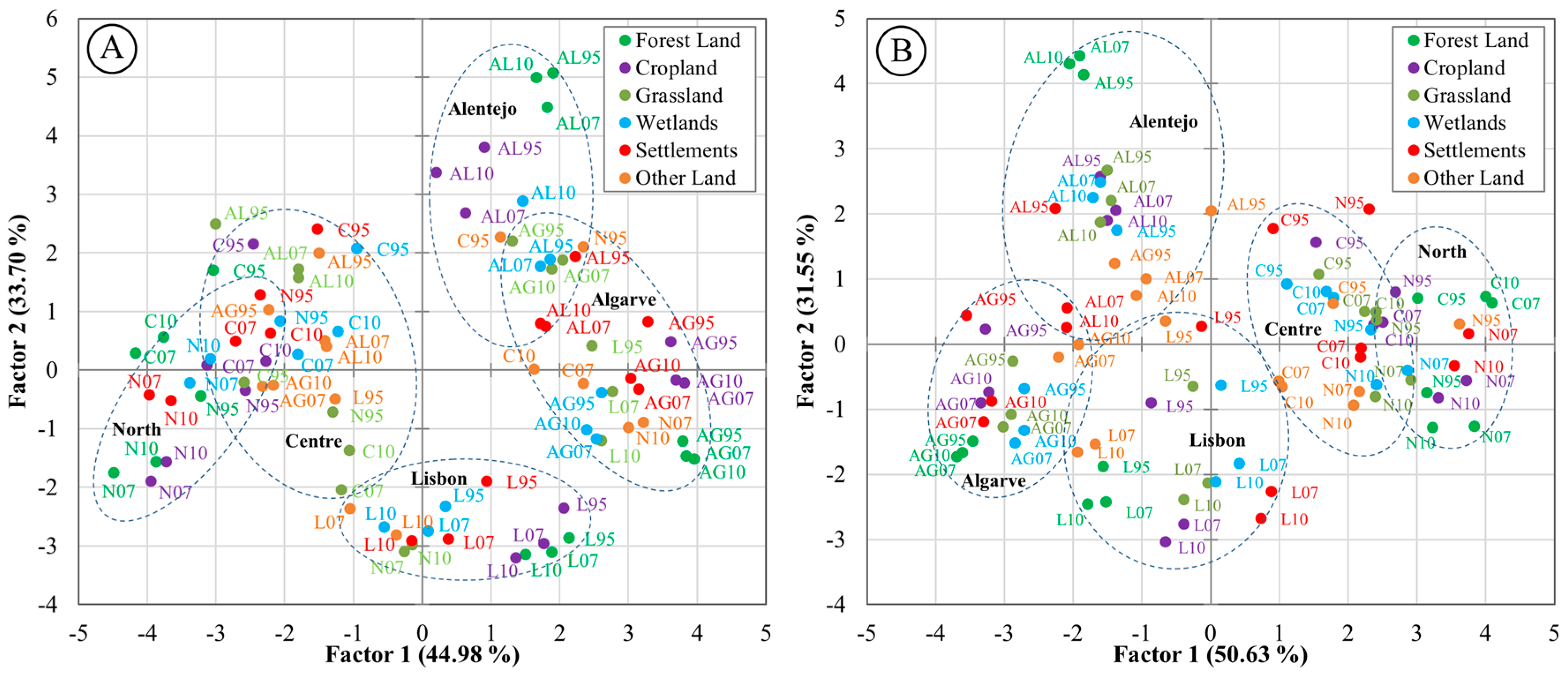
4.3. Driving Forces and Implications of the LUCC

The LUCC vary considerably over time in the NUTS II, but it is necessary to understand the driving forces in the LUCC in each region and possible resulting implications. The obtained correlations between socio-economic and environmental data available for the three years under review (see the variables in Table 2) and the LUCC (Table 6) show that variations of settlements correlate strongly with the employment (according to INE classification includes the following activities: agriculture, forestry, fishing, industry, construction and water), volume of exports, gross value added (industry, construction and water activities); resident population and roads. The previous factors are the driving forces behind the increase on artificial surfaces.
The changes in resident population per NUTS are positively correlated with the increase in settlements, owing largely to the construction of infrastructures (housing, commercial and industrial) during the last decade of the 20th century [28]. The LUCC for settlements has some implications, in particular, the increase in energy consumption by domestic and industrial consumers that showed high positive correlations (bold values in Table 6).
The forest land changes have different correlations with the variables considered in different subtypes of LUC covered by this class (Table 6). Employment in agriculture, forestry and fishing is the most important driving force in forest land changes, especially changes in areas occupied by Pinus pinaster, Eucalyptus, others quercus, broadleaves, coniferous and irrigated crops. In the case of Eucalyptus, the area variation was high, especially in the Centre (location of major pulp mills); this increase was reflected on the conversion of forested areas into Eucalyptus forest which brought about an increase in electricity consumption associated with the industrial sector, which is an implication derived from this type of LUCC.
LUCC of rain-fed and rice crops presented a high positive correlation with cereals production. The first type of LUC shows high correlation with the gross value added in the agriculture sector. In the case of variations of irrigated crops, there was a high positive correlation with the gross value added in agriculture sector, volume of exports, employment in agriculture and olive trees production. Although the LUC cartography of the irrigated crops is different from that of the olive groves, the statistical data include all the irrigated productions including the irrigated olive production from Alentejo. In recent years, the increase in number of irrigated plantations and new olive groves was due to the construction of a new dam and other infrastructures for water storage. These findings are attested in the case of irrigated olive groves in an extensive cultivation, especially in the Alentejo region, contributing to the increase of the gross value added in the agriculture, forestry and fishing.
It is noteworthy that, regarding the cropland class, the changes in the areas of vineyards correlated positively with wine production, volume of exports and employment in agriculture and industry. However, these LUCC also indicate the increase in electric energy consumption and in the number of electricity consumers in agriculture and industry.
The variation of the volumes stored by watershed is also clear in LUCC, especially in cultures that require water, as well as in the areas of expansion of the main water bodies in the total period under review. As for the variations of environmental expenditure in protection of biodiversity and landscape, this exhibit negative correlation with the LUCC which are potentially explained by fragmentation of LUC, indicating higher LUCC area mean lesser environmental expenditure or vice versa.
The per capita gross domestic product and the per capita purchasing power variables have very weak correlations with the LUCC. The per capita purchasing power presents a high negative correlation with the rain-fed and olive crops. These results can be explained by the increase and efficiency of the cereals and olive productions (increase of production volume in smaller areas) but also by the supply and demand of the food products markets and their derivatives from the types of LUC.
As previously explained, the LUCC in Portugal are associated with different driving forces, resulting in different implications at the regional level. These results were obtained using the Principal Component Analysis (PCA) performed with the LUCC in five NUTS II and the respective variables of driving forces and implications of these LUCC (Figure 6). These results showed distinct groupings among regions and also some asymmetry between driving forces and implications (Figure 6A,B). For example, the driving forces with LUCC of the Alentejo and Algarve regions in factor 1 (Figure 6A) present the higher positive values, while in the case of the implications (Figure 6B) the results are the opposite. According to the obtained results, factor 1 can be related with the spatial distribution of the regions and factor 2 identifies, in general terms, the LUCC associated with the driving forces as well as the implications.
Loadings of factor 1 of the driving forces analysis (Figure 6A) highlight the PCGDP and PCPP variables (0.47 and 0.59, respectively). The temporal analysis of these variables showed an increasing trend over time and also an effect of spatial continuity between the NUTS (increasing values from the North region to Lisbon and decreasing to the Algarve). These observations, in particular the effect of spatial continuity between NUTS, are also evident for the loadings of factor 1 of the implications analysis (Figure 6B), highlighting the high positive loadings for the CEEI and ECI variables (0.9 and 0.91, respectively).
The analysis of the loadings for the factor 2 of the driving forces analysis (Figure 6A) reflected the positive influence of the GVAA and OTP variables (0.60 and 0.68, respectively) representing the main driving forces for the analyzed LUCC. In the case of factor 2, the implications analysis (Figure 6B) highlights the CEEA positively (0.73). This variable constitutes one of the main implications of the observed LUCC. Among the considered LUCC and driving forces (Figure 6A), there is a clear distinction between the northern (North, Centre and Lisbon) and southern (Alentejo and Algarve) regions of Portugal. In fact, the landscape changes can be the result of the influence of regionally distinct factors (job offer, agricultural productivity, and water availability), culminating in the fragmentation of the territory. This fragmentation is also referred to in EEA reports [76] and Ribeiro et al. [77].
When performing the analysis of LUCC and its implications (Figure 6B), the clusters formed by regions are not so well defined (greater proximity or linkage distance) as in the case of driving forces, but there is still an approximation between them, providing a continuity from north to south or vice versa (Figure 6A,B). This means that implications associated with LUCC are observed in a spatially threaded process, with less demarcated transitions between regions when compared with the driving forces. These implications associated with environmental repercussions of LUCC have been mentioned by Chen et al. [78], and can include interference in energy sustainability in order to produce more energy (need for more dams, wind and photovoltaic farms and supply networks) to assure the energy demands of consumers (industry, agriculture and population). However, more energy supply also creates new possibilities to generate new LUCC.

5. Discussion and Conclusions

In Portugal, the LUCC are not static in time and space, because LUC that characterizes these landscapes is very dynamic along the total period under analysis. This LUCC dynamics are also referred to in other studies carried out in other territories (e.g., [17,20,63,79]).
In this research, LUCC exhibits different regional trends that are conditioned by the latitude factor, which was proved by the higher correlation among regions with higher spatial neighborhood. Different regional trends are also explained by different types of dominant LUC that characterize these regions at a certain time. The results show that the LUCC are differentiated for each NUTS II, considering the relative variation of area for each LUC type.
LUCC results are generally in line with other studies carried out in other areas, such as the increase of the urban areas (e.g., [55,80,81,82]) and the reduction of forest areas (e.g., [83,84,85]).
Crosschecking the area of LUCC with socio-economic and environmental indicators allowed the identification of the factors that have the greatest influence on LUCC, and consequently on landscape changes and ecological pressures (forest land degradation). However, the LUCC have different variations in the considered periods, in particular, the measures, policies and investments applied in each region. Thus, it was found that the landscape of Portugal suffered some changes between the analyzed periods, but this spatial differences are derived from certain LUCC in different regions, especially the resinous forest transition to other types of land cover (e.g., North and Centre) as well as the artificialization of soils (important in the Algarve region). The latter is marked essentially by the urban growth, that characterizes the complex urban system of the Iberian Peninsula [86,87]. These new land cover types exert great pressures on the territory’s ecosystems and they can cause problems in their sustainability, in particular in the consequent degradation of more fertile soils and other natural resources (e.g., drinking water) [36,57].
The temporal analysis of the driving forces results (Figure 6A) shows that the regions maintain proximity in most types of the LUC analyzed. However, there are some exceptions such as the settlements with greater linkage distance between 1995 observations and those of 2007 and 2010. Portugal went into economic recession in the last decade and this factor may have contributed to a slowdown in construction, which was particularly marked in the Centre and North regions where a higher percentage of settlements is located. According to Auch et al. [46] during times of recession new development typically declines and thus the rate of LUCC decreases.
By associating driving forces to LUCC different influences at the regional level were observed, namely LUCC into agriculture land derived from the construction of dams (Alentejo region), or the conversion of coniferous forest into eucalypt forest (Centre region) associated with increased gross value added (GVA) and employment in industry and forestry. Temporal differentiation of LUCC driving forces was also observed, particularly in the settlement expansion between 1995 and 2007 due to the construction of large infrastructures (e.g., highways, industrial complexes, or buildings), which is reflected on employment in industry and construction and respective GVA. However, certain LUCC have implications, particularly in energy consumption, for which different behavior between regions can be highlighted in this analysis.
It was also observed that certain LUCC have multiple driving forces of economic and social nature, like for instance the LUCC for settlements associated with employment (agriculture, forestry and industry), agricultural production (e.g., wine) and gross value added. The increase in irrigated crops was driven by the construction of dams, but also presents a strong correlation with the employment in the agricultural sector and the volume of exports. The implications associated with the analyzed LUCC highlights the consumption of electric energy. The increase of vineyards has been reflected in larger volume of exports to meet the increased demand for Portuguese wine products in recent years, according to the Portuguese Wine Institute (IVV). Because of these reasons, the soil conversion of these plantations was promoted and its expansion took place in different regions.
The driving forces of LUCC are very diverse depending on the territory. For example, in Cimandiri and Cibuni Watersheds (Java Island), Kelarestaghi and Jeloudar [79] highlighted the rainfall, soil type, slope, population, population density, and distance to urban areas as the most important variables for the LUCC (1978–2012); in northern Iran, in addition to the variables above mentioned, Aroengbinang [88] also highlighted the distance from drainage network; and, in Alt Emporda county (northeast of Spain), Serra et al. [42] referred to economic factors (e.g., agricultural subsidies) to promote irrigate crops versus dry crops, or social factors (e.g., senior agrarian holders) to justify the cultivated areas reduction. In Portugal, where the forest and agricultural land predominates, these LUCC driving forces also are important, i.e., the allocation of subsidies (to forest and agriculture), agricultural abandonment due to social and economic factors (e.g., low wages, emigration of the population, poor agricultural and forestry production, reduced competitiveness in Portuguese and international markets, etc.), the construction of large infrastructures such as dams, among other factors. In Ribeiro et al. [77] already referred to some of these factors as driving forces boosters of LUCC in Portugal (regional level), especially in agricultural land.
The landscape is the identity of a territory and it contributes to human well-being promoting important cultural, ecological, environmental and social functions [89]. In this context, landscape should be the target of constant evaluations due to political, socioeconomic and territorial decisions that are taken at the macro scale (e.g., distribution of social funds and agricultural development strategies and guidelines for the regional territory) with direct implications in LUC and natural ecosystems. Portugal has benefited from European Union (EU) funds for agricultural, forestry, transportation infrastructure, among others, allowing the development of large projects that culminated in LUCC in very large areas, especially in the Alentejo region [90,91]. In this sense, the results presented are important to estimate the potential implication of economic decisions to the economical (corporations and state) and political strategy to develop profitable economic sectors (e.g., Eucalyptus forest, vineyards, olive trees, rice crops). These decisions have inevitable consequences on the employment, electricity and energy consumption, volume of exports and gross value added. In addition, studies about the driving forces that control LUCC and possible implications on society, economy, environment and territory are important to the implementation of new land management guidelines and develop more effective strategies for ecosystems protection [92].
This research also shows that the LUCC projections are a challenging task because they involve several dynamic factors that can affect the LUCC in short periods. In addition, the example of the Alqueva dam construction caused deep LUCC in a short period, which would not have been predicted in a projection made with the 1995 LUC data.
The obtained results are also important to the LUC sustainability of the Portuguese territory, because the forest ecosystems have been continuously degraded by forest fires and human activities (e.g., disforestation). The forest surrounding the principal urban areas has diminished in each decade and the ecological pressure in these areas is high.

Supplementary Materials

The following are available online at www.mdpi.com/2071-1050/9/3/351/s1.

Acknowledgments

Bruno Meneses was financed through a grant of the Institute of Geography and Spatial Planning and Universidade de Lisboa, IGOT-UL (BD2015). This work was also financed by national funds through FCT—Portuguese Foundation for Science and Technology, I.P., under the framework of the project FORLAND—Hydro-geomorphologic risk in Portugal: driving forces and application for land use planning (PTDC/ATPGEO/1660/2014).

Author Contributions

Bruno M. Meneses worked on the methodology for LULC mapping and LUCC analyses, performed the experiment work and statistical analysis (LUCC and driving forces), produced the tables and figures, and wrote the paper. Eusébio Reis, Susana Pereira, Maria J. Vale and Rui Reis read and made improvements to the manuscript.

Conflicts of Interest

The authors declare no conflict of interest.

References

  1. Wang, J.; Zhao, Y.; Li, C.; Yu, L.; Liu, D.; Gong, P. Mapping global land cover in 2001 and 2010 with spatial-temporal consistency at 250 m resolution. ISPRS J. Photogramm. Remote Sens. 2014, 103, 38–47. [Google Scholar] [CrossRef]
  2. Rodriguez-Galiano, V.; Chica-Olmo, M. Land cover change analysis of a Mediterranean area in Spain using different sources of data: Multi-seasonal Landsat images, land surface temperature, digital terrain models and texture. Appl. Geogr. 2012, 35, 208–218. [Google Scholar] [CrossRef]
  3. Teixeira, Z.; Teixeira, H.; Marques, J.C. Systematic processes of land use/land cover change to identify relevant driving forces: Implications on water quality. Sci. Total Environ. 2014, 471, 1320–1335. [Google Scholar] [CrossRef] [PubMed] [Green Version]
  4. Direção Geral do Território. Land Use and Land Cover Evolutions in Continental Portugal. Work to Support Reporting of Emissions and Carbon Sequestration in the Sector Use and Land Use Changes. Kyoto Protocol and United Nations Framework Convention on Climate Changes; DGT: Lisbon, Portugal, 2014. [Google Scholar]
  5. Salvati, L.; De Zuliani, E.; Sabbi, A.; Cancellieri, L.; Tufano, M.; Caneva, G.; Savo, V. Land-cover changes and sustainable development in a rural cultural landscape of central Italy: classical trends and counter-intuitive results. Int. J. Sustain. Dev. World Ecol. 2016, 24, 1–10. [Google Scholar] [CrossRef]
  6. Meneses, B.M. Analysis of Land Use and Land Cover Changes in the Valley of the Varosa (Portugal) by Landsat-TM Images and its Influence on Soil Conservation. GeoFocus 2013, 13, 270–290. [Google Scholar]
  7. Li, Y.L.; Liu, K.; Li, L.; Xu, Z.X. Relationship of land use/cover on water quality in the Liao River basin, China. Procedia Environ. Sci. 2012, 13, 1484–1493. [Google Scholar] [CrossRef]
  8. Nunes, A.N.; de Almeida, A.C.; Coelho, C.O.A. Impacts of land use and cover type on runoff and soil erosion in a marginal area of Portugal. Appl. Geogr. 2011, 31, 687–699. [Google Scholar] [CrossRef]
  9. Jung, M.; Henkel, K.; Herold, M.; Churkina, G. Exploiting synergies of global land cover products for carbon cycle modeling. Remote Sens. Environ. 2006, 101, 534–553. [Google Scholar] [CrossRef]
  10. Office of Environment and Heritage (OEH). The Land and Soil Capability Assessment Scheme, Second Approximation: A General Rural Land Evaluation System for New SouthWales; OHE: Haymarket, Australia, 2012. [Google Scholar]
  11. Dumanski, J.; Pieri, C. Land quality indicators: Research plan. Agric. Ecosyst. Environ. 2000, 81, 93–102. [Google Scholar] [CrossRef]
  12. Frondoni, R.; Mollo, B.; Capotorti, G. A landscape analysis of land cover change in the Municipality of Rome (Italy): Spatio-temporal characteristics and ecological implications of land cover transitions from 1954 to 2001. Landsc. Urban Plan. 2011, 100, 117–128. [Google Scholar] [CrossRef]
  13. Campbell, D.J.; Lusch, D.P.; Smucker, T.A.; Wangui, E.E. Multiple Methods in the Study of Driving Forces of Land Use and Land Cover Change: A Case Study of SE Kajiado District, Kenya. Hum. Ecol. 2005, 33, 763–794. [Google Scholar] [CrossRef]
  14. Fichera, C.R.; Modica, G.; Pollino, M. Land Cover classification and change-detection analysis using multi-temporal remote sensed imagery and landscape metrics. Eur. J. Remote Sens. 2012, 45, 1–18. [Google Scholar] [CrossRef]
  15. Aitkenhead, M.J.; Aalders, I.H. Automating land cover mapping of Scotland using expert system and knowledge integration methods. Remote Sens. Environ. 2011, 115, 1285–1295. [Google Scholar] [CrossRef]
  16. Alcamo, J.; Schaldach, R.; Koch, J.; Kölking, C.; Lapola, D.; Priess, J. Evaluation of an integrated land use change model including a scenario analysis of land use change for continental Africa. Environ. Model. Softw. 2011, 26, 1017–1027. [Google Scholar] [CrossRef]
  17. Basse, R.M.; Omrani, H.; Charif, O.; Gerber, P.; Bódis, K. Land use changes modelling using advanced methods: Cellular automata and artificial neural networks. The spatial and explicit representation of land cover dynamics at the cross-border region scale. Appl. Geogr. 2014, 53, 160–171. [Google Scholar] [CrossRef]
  18. Liu, Y.; Luo, T.; Liu, Z.; Kong, X.; Li, J.; Tan, R. A comparative analysis of urban and rural construction land use change and driving forces: Implications for urban–rural coordination development in Wuhan, Central China. Habitat Int. 2015, 47, 113–125. [Google Scholar] [CrossRef]
  19. Long, H.; Tang, G.; Li, X.; Heilig, G.K. Socio-economic driving forces of land-use change in Kunshan, the Yangtze River Delta economic area of China. J. Environ. Manag. 2007, 83, 351–364. [Google Scholar] [CrossRef] [PubMed]
  20. Pang, A.; Li, C.; Wang, X.; Hu, J. Land use/cover change in response to driving forces of Zoige County, China. Procedia Environ. Sci. 2010, 2, 1074–1082. [Google Scholar] [CrossRef]
  21. Parcerisas, L.; Marull, J.; Pino, J.; Tello, E.; Coll, F.; Basnou, C. Land use changes, landscape ecology and their socioeconomic driving forces in the Spanish Mediterranean coast (El Maresme County, 1850–2005). Environ. Sci. Policy 2012, 23, 120–132. [Google Scholar] [CrossRef]
  22. Regos, A.; Ninyerola, M.; Moré, G.; Pons, X. Linking land cover dynamics with driving forces in mountain landscape of the Northwestern Iberian Peninsula. Int. J. Appl. Earth Obs. Geoinf. 2015, 38, 1–14. [Google Scholar] [CrossRef]
  23. Hansen, M.C.; Stehman, S.V.; Potapov, P.V. Quantification of Global Gross Forest Cover Loss; Fung, I.Y., Ed.; University of California: Berkeley, CA, USA, 2010. [Google Scholar]
  24. Meneses, B.M. The Influence of Forest Fire on Water Quality of São Domingos Stream Located in the Western Region of Portugal; High Institute of Agronomy of University of Lisbon: Lisbon, Portugal, 2013. [Google Scholar]
  25. Etter, A.; McAlpine, C.; Wilson, K.; Phinn, S.; Possingham, H. Regional patterns of agricultural land use and deforestation in Colombia. Agric. Ecosyst. Environ. 2006, 114, 369–386. [Google Scholar] [CrossRef]
  26. Pacheco, P. Agricultural expansion and deforestation in lowland Bolivia: The import substitution versus the structural adjustment model. Land Use Policy 2006, 23, 205–225. [Google Scholar] [CrossRef]
  27. Verburg, R.; Filho, S.R.; Lindoso, D.; Debortoli, N.; Litre, G.; Bursztyn, M. The impact of commodity price and conservation policy scenarios on deforestation and agricultural land use in a frontier area within the Amazon. Land Use Policy 2014, 37, 14–26. [Google Scholar] [CrossRef]
  28. Meneses, B.M.; Vale, M.J.; Reis, R. Uso e ocupação do solo. In Uso e Ocupação do Solo em Portugal Continental: Avaliação e Cenários Futuros. Projeto LANDYN; Direção Geral do Território, Ed.; Direção-Geral do Território: Lisboa, Portugal, 2014; pp. 16–52. [Google Scholar]
  29. Yoder, R.E.; Freeland, R.S.; Ammons, J.T.; Leonard, L.L. Mapping agricultural fields with GPR and EMI to identify offsite movement of agrochemicals. J. Appl. Geophys. 2001, 47, 251–259. [Google Scholar] [CrossRef]
  30. Schmitz, J.; Hahn, M.; Brühl, C.A. Agrochemicals in field margins—An experimental field study to assess the impacts of pesticides and fertilizers on a natural plant community. Agric. Ecosyst. Environ. 2014, 193, 60–69. [Google Scholar] [CrossRef]
  31. Alister, C.; Kogan, M. ERI: Environmental risk index. A simple proposal to select agrochemicals for agricultural use. Crop Prot. 2006, 25, 202–211. [Google Scholar] [CrossRef]
  32. Grainger, A.; Francisco, H.A.; Tiraswat, P. The impact of changes in agricultural technology on long-term trends in deforestation. Land Use Policy 2003, 20, 209–223. [Google Scholar] [CrossRef]
  33. Paz, J.M.; Sánchez, J.; Visconti, F. Combined use of GIS and environmental indicators for assessment of chemical, physical and biological soil degradation in a Spanish Mediterranean region. J. Environ. Manag. 2006, 79, 150–162. [Google Scholar] [CrossRef] [PubMed]
  34. Shu, B.; Zhang, H.; Li, Y.; Qu, Y.; Chen, L. Spatiotemporal variation analysis of driving forces of urban land spatial expansion using logistic regression: A case study of port towns in Taicang City, China. Habitat Int. 2014, 43, 181–191. [Google Scholar] [CrossRef]
  35. Ascione, M.; Campanella, L.; Cherubini, F.; Ulgiati, S. Environmental driving forces of urban growth and development. Landsc. Urban Plan. 2009, 93, 238–249. [Google Scholar] [CrossRef]
  36. Meneses, B.M.; Reis, E.; Vale, M.J.; Reis, R. Modeling the Probability of Surface Artificialization in Zêzere Watershed (Portugal) Using Environmental Data. Water 2016, 8, 1–19. [Google Scholar] [CrossRef]
  37. Amato, F.; Maimone, B.A.; Martellozzo, F.; Nolè, G.; Murgante, B. The Effects of Urban Policies on the Development of Urban Areas. Sustainability 2016, 8, 1–22. [Google Scholar] [CrossRef] [Green Version]
  38. Martellozzo, F. Forecasting High Correlation Transition of Agricultural Landscapes into Urban Areas. Int. J. Agric. Environ. Inf. Syst. 2012, 3, 22–34. [Google Scholar] [CrossRef]
  39. Nolè, G.; Murgante, B.; Calamita, G.; Lanorte, A.; Lasaponara, R. Evaluation of urban sprawl from space using open source technologies. Ecol. Inform. 2015, 26, 151–161. [Google Scholar] [CrossRef]
  40. Nestroy, O. Soil sealing in Austria and its consequences. Ecohydrol. Hydrobiol. 2006, 6, 171–173. [Google Scholar] [CrossRef]
  41. Scalenghe, R.; Marsan, F.A. The anthropogenic sealing of soils in urban areas. Landsc. Urban Plan. 2009, 90, 1–10. [Google Scholar] [CrossRef]
  42. Serra, P.; Pons, X.; Saurí, D. Land-cover and land-use change in a Mediterranean landscape: A spatial analysis of driving forces integrating biophysical and human factors. Appl. Geogr. 2008, 28, 189–209. [Google Scholar] [CrossRef]
  43. König, H.J.; Uthes, S.; Schuler, J.; Zhen, L.; Purushothaman, S.; Suarma, U.; Sghaier, M.; Makokha, S.; Helming, K.; Sieber, S.; et al. Regional impact assessment of land use scenarios in developing countries using the FoPIA approach: Findings from five case studies. J. Environ. Manag. 2013, 127, S56–S64. [Google Scholar] [CrossRef] [PubMed]
  44. Hong, Z.; Hailin, L.; Zhen, C. Analysis of Land Use Dynamic Change and Its Impact on the Water Environment in Yunnan Plateau Lake Area—A Case Study of the Dianchi Lake Drainage Area. Procedia Environ. Sci. 2011, 10, 2709–2717. [Google Scholar] [CrossRef]
  45. Mouri, G.; Takizawa, S.; Oki, T. Spatial and temporal variation in nutrient parameters in stream water in a rural-urban catchment, Shikoku, Japan: Effects of land cover and human impact. J. Environ. Manag. 2011, 92, 1837–1848. [Google Scholar] [CrossRef] [PubMed]
  46. Auch, R.F.; Napton, D.E.; Kambly, S.; Moreland, T.R.; Sayler, K.L. The driving forces of land change in the Northern Piedmont of the United States. Geogr. Rev. 2012, 102, 53–75. [Google Scholar] [CrossRef]
  47. Kanianska, R.; Kizeková, M.; Nováček, J.; Zeman, M. Land-use and land-cover changes in rural areas during different political systems: A case study of Slovakia from 1782 to 2006. Land Use Policy 2014, 36, 554–566. [Google Scholar] [CrossRef]
  48. Briassoulis, H. Land Use, Land Cover and Soil Sciences—Land-use, land-cover changes and global aggregate impacts. Encycl. Life Support Syst. 2009, I, 6. [Google Scholar]
  49. Lambin, E.F.; Turner, B.L.; Geist, H.J.; Agbola, S.B.; Angelsen, A.; Bruce, J.W.; Coomes, O.T.; Dirzo, R.; Fischer, G.; Folke, C.; et al. The causes of land-use and land-cover change: Moving beyond the myths. Glob. Environ. Chang. 2001, 11, 261–269. [Google Scholar] [CrossRef]
  50. Rayner, S.; Bretherton, F.; Buol, S.; Fosberg, M.; Grossmann, W.; Houghton, R.A.; Lal, R.; Lee, J.; Lonergan, S.; Olson, J.; et al. A wiring diagram for the study of land-use/cover change: Report of Working Group A. In Changes in Land Use and Land Cover: A Global Perspective; Meyer, W.B., Turner, B.L.I., Eds.; Cambridge University Press: Cambridge, UK, 1994; pp. 13–53. [Google Scholar]
  51. Meyer, W.B.; Turner, B.L.I. Changes in Land Use and Land Cover: A Global Perspective, 1st ed.; Meyer, W.B., Turner, B.L.I., Eds.; Cambridge University Press: Cambridge, UK, 1994. [Google Scholar]
  52. Meneses, B.M.; Vale, M.J.; Reis, R.; Saraiva, R. Metodologias para a avaliação das alterações do uso e ocupação do solo em Portugal Continental nas últimas três décadas. CIDADES Comunidades Territ. 2013, 27, 50–60. [Google Scholar] [CrossRef]
  53. Brum Ferreira, D. Evolução da Paisagem de Montado no Alentejo Interior ao Longo do Século XX: Dinâmicas e incidências ambientais. Finisterra Rev. Port. Geogr. 2001, 36, 179–193. [Google Scholar] [CrossRef]
  54. Moreira, F.; Ferreira, P.G.; Rego, F.C.; Bunting, S. Landscape changes and breeding bird assemblages in northwestern Portugal: The role of fire. Landsc. Ecol. 2001, 16, 175–187. [Google Scholar] [CrossRef]
  55. Pôças, I.; Cunha, M.; Marcal, A.R.S.; Pereira, L.S. An evaluation of changes in a mountainous rural landscape of Northeast Portugal using remotely sensed data. Landsc. Urban Plan. 2011, 101, 253–261. [Google Scholar] [CrossRef]
  56. Pôças, I.; Cunha, M.; Pereira, L.S. Remote sensing based indicators of changes in a mountain rural landscape of Northeast Portugal. Appl. Geogr. 2011, 31, 871–880. [Google Scholar] [CrossRef]
  57. Meneses, B.M.; Reis, R.; Vale, M.J.; Saraiva, R. Land use and land cover changes in Zêzere watershed (Portugal)—Water quality implications. Sci. Total Environ. 2015, 527–528, 439–447. [Google Scholar] [CrossRef] [PubMed]
  58. Hersperger, A.M.; Bürgi, M. Going beyond landscape change description: Quantifying the importance of driving forces of landscape change in a Central Europe case study. Land Use Policy 2009, 26, 640–648. [Google Scholar] [CrossRef]
  59. Bičı́k, I.; Jeleček, L.; Štěpánek, V. Land-use changes and their social driving forces in Czechia in the 19th and 20th centuries. Land Use Policy 2001, 18, 65–73. [Google Scholar] [CrossRef]
  60. Alarcão, A. Êxodo Rural e Atracção Urbana no Continente. Análise Soc. 1964, VII–VIII, 511–573. [Google Scholar]
  61. Instituto Geográfico Português. Carta de Uso e Ocupação do Solo de Portugal Continental para 2007 (COS2007). Memória Descritiva; IGP, Ed.; Instituto Geográfico Português/Direção Geral do Território: Lisboa, Portugal, 2010. [Google Scholar]
  62. Shi, P.; Chen, J.; Pan, Y. Land use change mechanism in Shenzhen City. Acta Geogr. Sin. 2000, 67, 151–160. [Google Scholar]
  63. Zhang, X.; Zhang, L.; He, C.; Li, J.; Jiang, Y.; Ma, L. Quantifying the impacts of land use/land cover change on groundwater depletion in Northwestern China—A case study of the Dunhuang oasis. Agric. Water Manag. 2014, 146, 270–279. [Google Scholar] [CrossRef]
  64. Jiang, P.; Cheng, L.; Li, M.; Zhao, R.; Huang, Q. Analysis of landscape fragmentation processes and driving forces in wetlands in arid areas: A case study of the middle reaches of the Heihe River, China. Ecol. Indic. 2014, 46, 240–252. [Google Scholar] [CrossRef]
  65. Marques, T.S. Dinâmicas territoriais e as relações urbano-rurais. Rev. Fac. Let. Geogr. 2003, XIX, 507–521. [Google Scholar]
  66. Oliveira, S.L.J.; Pereira, J.M.C.; Carreiras, J.M.B. Fire frequency analysis in Portugal (1975–2005), using Landsat-based burnt area maps. Int. J. Wildl. Fire 2012, 21, 48–60. [Google Scholar] [CrossRef]
  67. Leite, F.F.; Bento Gonçalves, A.; Vieira, A. The recurrence interval of forest fires in Cabeço da Vaca (Cabreira Mountain-northwest of Portugal). Environ. Res. 2011, 111, 215–221. [Google Scholar] [CrossRef] [PubMed]
  68. Pereira, M.G.; Trigo, R.M.; da Camara, C.C.; Pereira, J.M.C.; Leite, S.M. Synoptic patterns associated with large summer forest fires in Portugal. Agric. For. Meteorol. 2005, 129, 11–25. [Google Scholar] [CrossRef]
  69. Esteves, T.C.J.; Kirkby, M.J.; Shakesby, R.A.; Ferreira, A.J.D.; Soares, J.A.A.; Irvine, B.J.; Ferreira, C.S.S.; Coelho, C.O.A.; Bento, C.P.M.; Carreiras, M.A. Mitigating land degradation caused by wildfire: Application of the PESERA model to fire-affected sites in central Portugal. Geoderma 2012, 191, 40–50. [Google Scholar] [CrossRef]
  70. Lloret, F.; Marí, G. A comparison of the medieval and the current fire regimes in managed pine forests of Catalonia (NE Spain). For. Ecol. Manag. 2001, 141, 155–163. [Google Scholar] [CrossRef]
  71. Goes, F.A. Modelação do Crescimento da Árvore Individual de Eucalyptus Globulus Labill; Universidade Nova de Lisboa: Lisbon, Portugal, 2012. [Google Scholar]
  72. American Forces Network (AFN). Nemátodo da Madeira do Pinheiro—Atividades Realizadas no Âmbito do seu Controlo; AFN: Lisboa, Portugal, 2012. [Google Scholar]
  73. Daniel, A.C.M. Caracterização do Sector Turístico em Portugal. Rev. Estud. Politéc. 2010, VIII, 255–276. [Google Scholar]
  74. Aguiar, C.; Rodrigues, O.; Azevedo, J.; Domingos, T. Montanha. In Ecossistemas e Bem-Estar Humano. Avaliação para Portugal do Millennium Ecosystem Assessment; Pereira, H.M., Domingos, T., Vicente, L., Proença, V., Eds.; Escolar Editora: Lisboa, Portugal, 2009; pp. 295–339. [Google Scholar]
  75. Carpio, A.J.; Oteros, J.; Tortosa, F.S.; Guerrero-Casado, J. Land use and biodiversity patterns of the herpetofauna: The role of olive groves. Acta Oecol. 2016, 70, 103–111. [Google Scholar] [CrossRef]
  76. European Economic Area (EEA). Landscape Fragmentation in Europe: Joint EEA-FOEN Report; EEA: Bern, Switzerland, 2011. [Google Scholar]
  77. Ribeiro, M.; Vale, M.J.; Reis, R. Identificação das principais forças motrizes: Abordagem quantitativa. In Uso e Ocupação do Solo em Portugal Continental: Avaliação e Cenários Futuros. Projeto LANDYN; DGT, Ed.; Direção-Geral do Território: Lisboa, Portugal, 2014; pp. 81–88. [Google Scholar]
  78. Chen, L.; Yang, X.; Chen, L.; Li, L. Impact assessment of land use planning driving forces on environment. Environ. Impact Assess. Rev. 2015, 55, 126–135. [Google Scholar] [CrossRef]
  79. Kelarestaghi, A.; Jeloudar, Z.J. Land use/cover change and driving force analyses in parts of northern Iran using RS and GIS techniques. Arab. J. Geosci. 2011, 4, 401–411. [Google Scholar] [CrossRef]
  80. García-Frapolli, E.; Ayala-Orozco, B.; Bonilla-Moheno, M.; Espadas-Manrique, C.; Ramos-Fernández, G. Biodiversity conservation, traditional agriculture and ecotourism: Land cover/land use change projections for a natural protected area in the northeastern Yucatan Peninsula, Mexico. Landsc. Urban Plan. 2007, 83, 137–153. [Google Scholar]
  81. Rounsevell, M.D.A.; Reginster, I.; Araújo, M.B.; Carter, T.R.; Dendoncker, N.; Ewert, F.; House, J.I.; Kankaanpää, S.; Leemans, R.; Metzger, M.J.; et al. A coherent set of future land use change scenarios for Europe. Agric. Ecosyst. Environ. 2006, 114, 57–68. [Google Scholar] [CrossRef]
  82. Hegazy, I.R.; Kaloop, M.R. Monitoring urban growth and land use change detection with GIS and remote sensing techniques in Daqahlia governorate Egypt. Int. J. Sustain. Built Environ. 2015. [Google Scholar] [CrossRef]
  83. Gautam, A.P.; Webb, E.L.; Shivakoti, G.P.; Zoebisch, M.A. Land use dynamics and landscape change pattern in a mountain watershed in Nepal. Agric. Ecosyst. Environ. 2003, 99, 83–96. [Google Scholar] [CrossRef]
  84. Staus, N.L.; Strittholt, J.R.; DellaSala, D.A.; Robinson, R. Rate and pattern of forest disturbance in the Klamath-Siskiyou ecoregion, USA between 1972 and 1992. Landsc. Ecol. 2002, 17, 455–470. [Google Scholar] [CrossRef]
  85. Bebi, P.; Seidl, R.; Motta, R.; Fuhr, M.; Firm, D.; Krumm, F.; Conedera, M.; Ginzler, C.; Wohlgemuth, T.; Kulakowski, D. Changes of forest cover and disturbance regimes in the mountain forests of the Alps. For. Ecol. Manag. 2016. In press. [Google Scholar] [CrossRef]
  86. Lois-González, R.C. A model of spanish-portuguese urban growth: The atlantic axis. Dela 2004, 21, 281–294. [Google Scholar]
  87. Carballada, Á.M.; Marques, T.M. Urban areas in the Iberian Peninsula. The delineation exercise. Geograifa 2016, 62, 1–3. [Google Scholar]
  88. Aroengbinang, B.W. Driving Force Analysis of Landuse and Cover Changes in Cimandiri and Cibuni Watersheds. Procedia Environ. Sci. 2015, 24, 184–188. [Google Scholar] [CrossRef]
  89. Roca, M.N.O.; Leitão, N. População e sustentabilidade da paisagem agrícola em Portugal: Uma tipologia de concelhos. In X Colóquio Ibérico de Geografia “A Geografia Ibérica no Contexto Europeu”; Pedro-Rego, P., Henriques, M.V., Eds.; Universidade de Évora: Évora, Portugal, 2005; pp. 1–18. [Google Scholar]
  90. Canada Communicable Disease Report (CCDR). Relatório de Aplicação de Fundos Comunitários na Região do Alentejo; CCDR: Évora, Portugal, 2014. [Google Scholar]
  91. Tomaz, C.V.B.R. Avaliação da Implementação de Projetos Florestais No Âmbito do Programa “RURIS-FTA” na Beira Inteior Sul; Instituto Politécnico de Castelo Branco: Castelo Branco, Portugal, 2011. [Google Scholar]
  92. Wu, G.; Gao, Y.; Wang, Y.; Wang, Y.; Xu, D. Land-use/land cover changes and their driving forces around wetlands in Shangri-La County, Yunnan Province, China. Int. J. Sustain. Dev. World Ecol. 2014, 22, 110–116. [Google Scholar] [CrossRef]
Figure 1. Land use/cover area of Portugal in 1995, 2007 and 2010.
Sustainability 09 00351 g001
Figure 2. Spatial distribution of LUC in Portugal in 1995, 2007 and 2010. Data source: DGT.
Sustainability 09 00351 g002
Figure 3. Methodological scheme used in the LUCC and driving forces and implications assessment.
Sustainability 09 00351 g003
Figure 4. Coefficient of variation (Lcv) of LUC (level I) in Continental Portugal (years 1995, 2007 and 2010).
Sustainability 09 00351 g004
Figure 5. Absolute (A); and relative (B) LUCC in NUTS II of Portugal (1995–2010).
Sustainability 09 00351 g005
Figure 6. Principal components results of the LUCC classification and driving forces (A) and implications (B) variables by NUTS II for the complete period. N, North; C, Centre; L, Lisbon; AL, Alentejo; and AG, Algarve; and the numbers after the letter correspond to the year: 95, 1995; 07, 2007; and 10, 2010.
Sustainability 09 00351 g006
Table 1. Area (%) of Portugal by LUC types in NUTS II for the years 1995, 2007 and 2010.
LUCNorth
(23.93% of Total Area)
Centre
(31.70% of Total Area)
Lisbon
(3.32% of Total Area)
Alentejo
(35.44% of Total Area)
Algarve
(5.62% of Total Area)
Level ILevel II199520072010199520072010199520072010199520072010199520072010
Forest Land and othersPinus pinaster3.863.983.958.938.468.350.290.280.280.990.960.950.070.070.07
Quercus suber0.390.400.390.630.700.700.260.260.267.728.068.110.820.850.85
Eucalyptus1.491.701.873.524.674.800.160.150.152.212.262.250.350.360.36
Quercus rotundifolia0.090.100.090.540.550.550.000.000.005.965.735.720.310.300.30
Other quercus1.241.311.310.971.041.050.000.000.000.070.070.070.000.000.00
Other broadleaves1.231.991.430.881.081.090.070.080.080.300.300.310.180.170.17
Pinus pinea0.000.010.010.070.110.110.150.170.171.111.551.560.260.490.49
Other coniferous0.050.070.070.050.090.090.010.010.010.000.000.000.000.000.00
Rain-fed crops3.452.902.884.333.623.620.500.440.436.175.425.280.400.360.36
Irrigated crops1.611.361.371.471.491.500.360.320.311.211.431.420.050.050.05
Rice0.000.000.000.120.120.120.020.040.050.260.250.260.000.000.00
CroplandVineyards1.081.231.240.680.660.650.130.120.120.380.460.470.030.020.02
Olive0.961.031.051.551.361.360.030.030.032.232.292.480.330.310.31
Other permanent0.250.320.320.340.340.330.040.030.030.050.060.060.370.340.34
GrasslandGrassland0.400.380.361.431.511.450.270.260.264.594.214.100.290.230.23
WetlandsWetlands0.210.210.210.370.390.400.200.200.200.500.760.770.200.210.21
SettlementsSettlements1.341.671.721.291.641.700.550.690.710.420.580.600.190.280.30
Other LandShrubland5.544.895.284.193.533.520.260.230.221.200.960.951.721.521.51
Other Land0.720.390.380.310.320.320.020.020.020.070.080.080.040.050.05
Table 2. Socioeconomic and environmental statistical data considered in analysis.
VariableDescription
Driving forcesCPCereals production (kg)
EIExport intensity (%)
EMPAEmployment (No.)—agriculture, forestry and fishing
EMPIEmployment (No.)—industry, construction and water
EMPTEmployment (No.)
ERPBLEnvironmental revenues (€)—protection of biodiversity and landscape
ERWMEnvironmental revenues (€)—waste management
GVAAGross value added (€)—agriculture, forestry and fishing
GVAIGross value added (€)—industry, construction and water
OTPOlive trees production (kg)
PCGDPPer capita gross domestic product (€/per inhabitant)
PCPPPer capita purchasing power (%/per inhabitant)
RdRoads (km)
RPResident population (No.)
VPVineyard production (kg)
VSWVolumes stored by watershed (106 m3)
ImplicationsCEEAConsumption of electric energy (kWh)—agriculture, forestry and fishing
CEEDConsumption of electric energy (kWh)—domestic
CEEIConsumption of electric energy (kWh)—industry, construction and water
CEETConsumption of electric energy (kWh)—total
ECAElectricity consumers (No.)—agriculture, forestry and fishing
ECDElectricity consumers (No.)—domestic
ECIElectricity consumers (No.)—industry, construction and water
ECTElectricity consumers (No.)—total
EEPBLPCEnvironmental expenditure (€/per inhabitant)—protection of biodiversity and landscape
EETPCEnvironmental expenditure (€/per inhabitant)—total
Table 3. Spatial agreement of LUC between different periods (see Supplementary Tables S2–S4).
PeriodsOverall Unchanged (%)Overall Changes (%)Kappa Coefficient (%)
1995–2007841682.4
2007–201097.12.996.6
1995–201083.416.681.8
Table 4. Correlation (r) and determination (r2) coefficients between areas of LUCC (absolute and relative changes) obtained to the different periods (dataset 1: 1995–2007; dataset 2: 2007–2010) (significance level p < 0.05).
NUTS IIAbsolute ChangesRelative Changes
rr2rr2
North−0.670.45−0.150.02
Centre0.720.520.450.20
Lisbon0.800.630.800.65
Alentejo0.620.390.220.05
Algarve0.490.240.350.12
Table 5. Correlation coefficients between LUCC area variations (absolute and relative changes) between all NUTS II combinations (significance level p < 0.05).
NUTS IIAbsolute ChangesRelative Changes
Input 1Input 21995–20101995–20072007–20101995–20101995–20072007–2010
NorthCentre0.680.580.150.560.560.16
Lisbon0.630.52−0.070.040.130.00
Alentejo0.510.410.020.430.410.07
Algarve0.360.40−0.160.740.710.07
CentreLisbon0.410.420.160.170.330.04
Alentejo0.400.440.150.470.420.40
Algarve0.390.390.210.450.440.28
LisbonAlentejo0.380.390.250.000.020.28
Algarve0.480.470.630.130.220.11
AlentejoAlgarve0.570.610.220.550.560.14
Table 6. Correlation coefficients average values between the LUCC areas of the NUTS and the driving forces and implications variables for the complete period (significance level p < 0.05).
Land Use/Cover Classes
Pinus pinasterQuercus suberEucalyptusQuercus rotundifoliaOther quercusOther broadleavesPinus pineaOther ConiferousRain-Fed cropsIrrigated cropsRicevineyardsOliveOther permanentGrasslandWetlandsSettlementsShrublandOther Land
Driving forcesCPn.a.n.a.n.a.n.a.n.a.n.a.n.a.n.a.0.940.670.93n.a.n.a.n.a.0.960.87n.a.n.a.n.a.
EI0.55−0.040.49−0.020.770.76−0.220.700.480.810.110.860.35−0.07n.a.n.a.n.a.n.a.n.a.
EMPA0.97−0.310.80−0.270.910.81−0.470.930.420.75−0.010.750.310.56n.a.n.a.0.89n.a.n.a.
EMPI0.51−0.490.21−0.480.850.83−0.650.710.080.52−0.410.84−0.090.24n.a.−0.380.83n.a.n.a.
EMPT0.42−0.590.11−0.570.660.60−0.710.62−0.120.32−0.420.60−0.290.01n.a.−0.460.75n.a.n.a.
ERPBL0.73−0.280.65−0.240.620.62−0.370.770.200.470.030.470.140.31−0.080.010.740.440.39
ERWM0.38−0.310.31−0.310.580.63−0.370.64−0.010.30−0.210.55−0.040.24−0.25−0.160.720.430.29
GVAA0.730.400.850.450.550.480.210.530.900.890.630.570.840.160.61n.a.n.a.0.520.53
GVAI0.44−0.480.21−0.460.710.71−0.610.69−0.020.40−0.340.70−0.160.07−0.39n.a.0.830.550.56
OTPn.a.n.a.n.a.n.a.n.a.n.a.n.a.n.a.0.800.74n.a.n.a.0.84n.a.n.a.0.73n.a.n.a.n.a.
PCGDP−0.42−0.13−0.40−0.16−0.45−0.410.05−0.31−0.52−0.51−0.15−0.46−0.44−0.36−0.24−0.13−0.25−0.56−0.54
PCPP−0.52−0.36−0.65−0.38−0.51−0.52−0.23−0.41−0.72−0.66−0.40−0.54−0.73−0.48−0.47−0.43−0.37n.a.n.a.
Rdn.a.n.a.n.a.n.a.n.a.n.a.n.a.n.a.n.a.n.a.n.a.n.a.n.a.n.a.n.a.n.a.0.74n.a.n.a.
RP0.43−0.540.13−0.520.710.67−0.680.64−0.050.39−0.400.69−0.220.03−0.45−0.430.780.580.64
VSW0.250.580.550.570.01−0.020.550.100.680.630.720.170.79−0.560.650.870.18−0.17−0.02
VPn.a.n.a.n.a.n.a.n.a.n.a.n.a.n.a.n.a.n.a.n.a.0.89n.a.n.a.n.a.0.330.80n.a.n.a.
ImplicationsCEEA0.440.510.750.520.200.200.460.380.650.640.710.260.71−0.140.640.79n.a.n.a.n.a.
CEEDn.a.n.a.n.a.n.a.n.a.n.a.n.a.n.a.n.a.n.a.n.a.n.a.n.a.n.a.n.a.n.a.0.77n.a.n.a.
CEEI0.73−0.410.55−0.380.800.74−0.570.870.190.60−0.120.710.040.15−0.22−0.150.93n.a.n.a.
CEET0.47−0.490.25−0.480.650.62−0.610.69−0.060.36−0.290.59−0.190.03−0.38−0.320.80n.a.n.a.
ECA0.97−0.240.87−0.200.900.81−0.400.960.460.780.070.740.360.530.00n.a.n.a.n.a.n.a.
ECDn.a.n.a.n.a.n.a.n.a.n.a.n.a.n.a.n.a.n.a.n.a.n.a.n.a.n.a.n.a.n.a.0.80n.a.n.a.
ECI0.64−0.440.35−0.420.900.85−0.610.760.210.61−0.320.850.040.35−0.31−0.290.83n.a.n.a.
ECT0.49−0.580.20−0.560.700.66−0.710.70−0.090.35−0.390.63−0.250.08−0.47−0.420.820.530.56
EEPBLPC−0.32−0.26−0.35−0.29−0.42−0.41−0.06−0.24−0.61−0.59−0.25−0.52−0.52−0.14−0.35−0.23−0.25−0.50−0.52
EETPC−0.66−0.09−0.62−0.13−0.75−0.700.16−0.65−0.69−0.86−0.26−0.80−0.53−0.08−0.27−0.20−0.71−0.68−0.76
CP—Cereals production (kg); EI—Export intensity (%); EMPA—Employment (No.), agriculture, forestry and fishing; EMPI—Employment (No.), industry, construction and water; EMPT—Employment (No.); ERPBL—Environmental revenues (€), protection of biodiversity and landscape; ERWM—Environmental revenues (€), waste management; GVAA—Gross value added (€), agriculture, forestry and fishing; GVAI—Gross value added (€), industry, construction and water; OTP—Olive trees production (kg); PCGDP—Per capita gross domestic product (€/per inhabitant); PCPP—Per capita purchasing power (%/per inhabitant); Rd—Roads (km); RP—Resident population (No.); VP—Vineyard production (kg); VSW—Volumes stored by watershed (106 m3); CEEA—Consumption of electric energy (kWh), agriculture, forestry and fishing; CEED—Consumption of electric energy (kWh), domestic; CEEI—Consumption of electric energy (kWh), industry, construction and water; CEET—Consumption of electric energy (kWh), total; ECA—Electricity consumers (No.), agriculture, forestry and fishing; ECD—Electricity consumers (No.), domestic; ECI—Electricity consumers (No.), industry, construction and water; ECT—Electricity consumers (No.), total; EEPBLPC—Environmental expenditure (€/per inhabitant), protection of biodiversity and landscape; EETPC—Environmental expenditure (€/per inhabitant), total; n.a.—not applicable.

