
Forest Fragmentation and Driving Forces in Yingkou, Northeastern China

Abstract
:1. Introduction
2. Materials and Methods
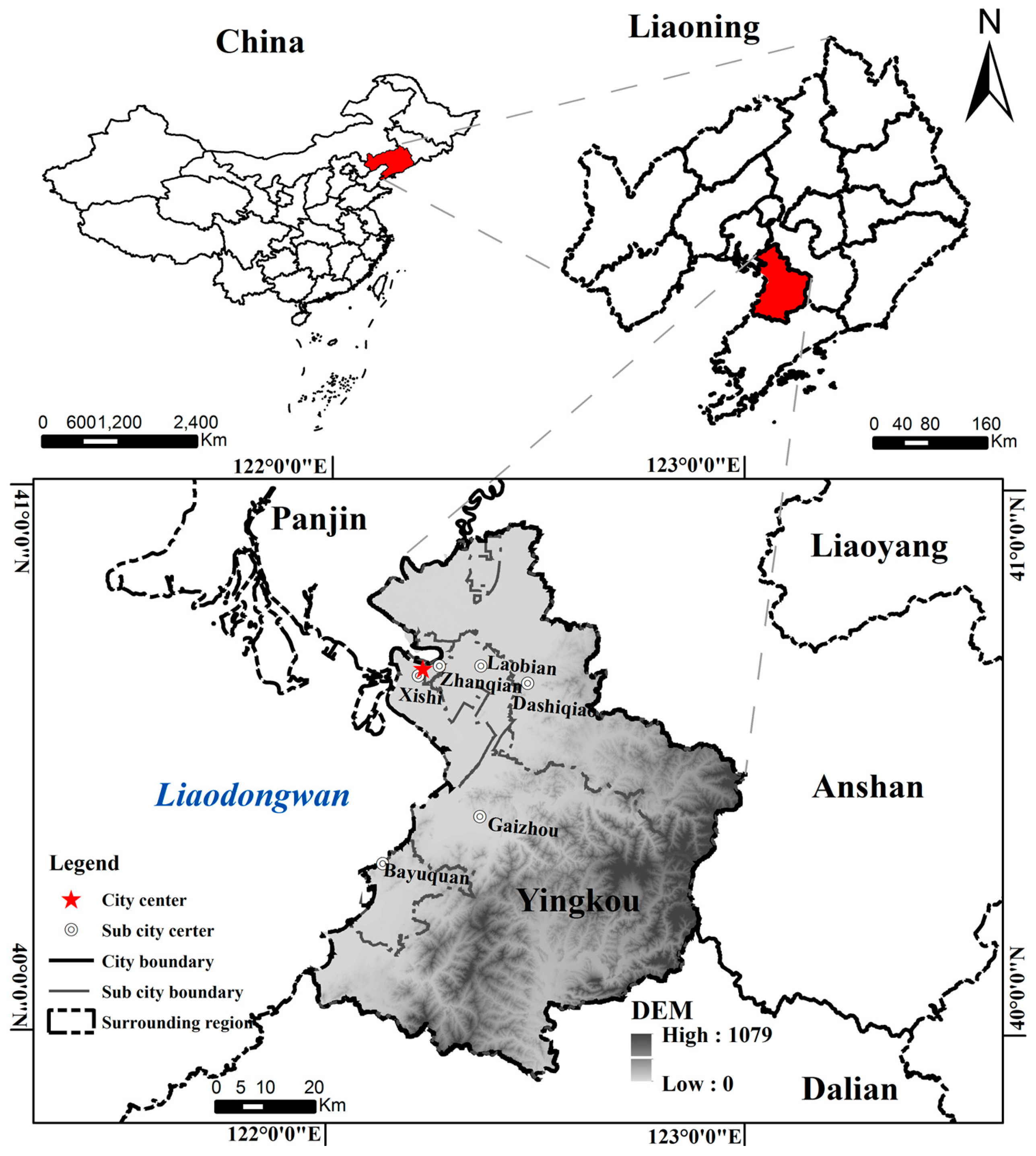
2.1. Study Area
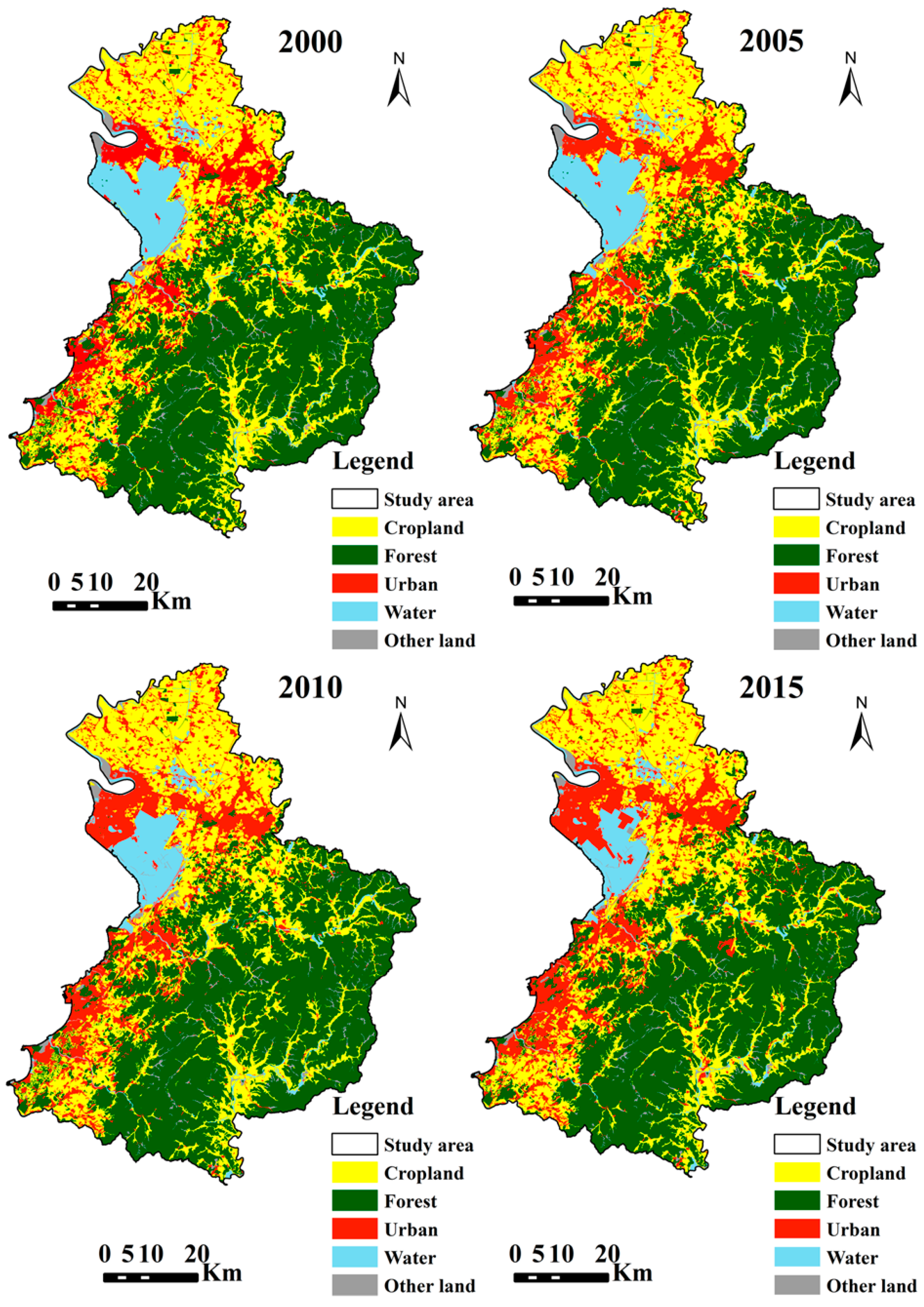
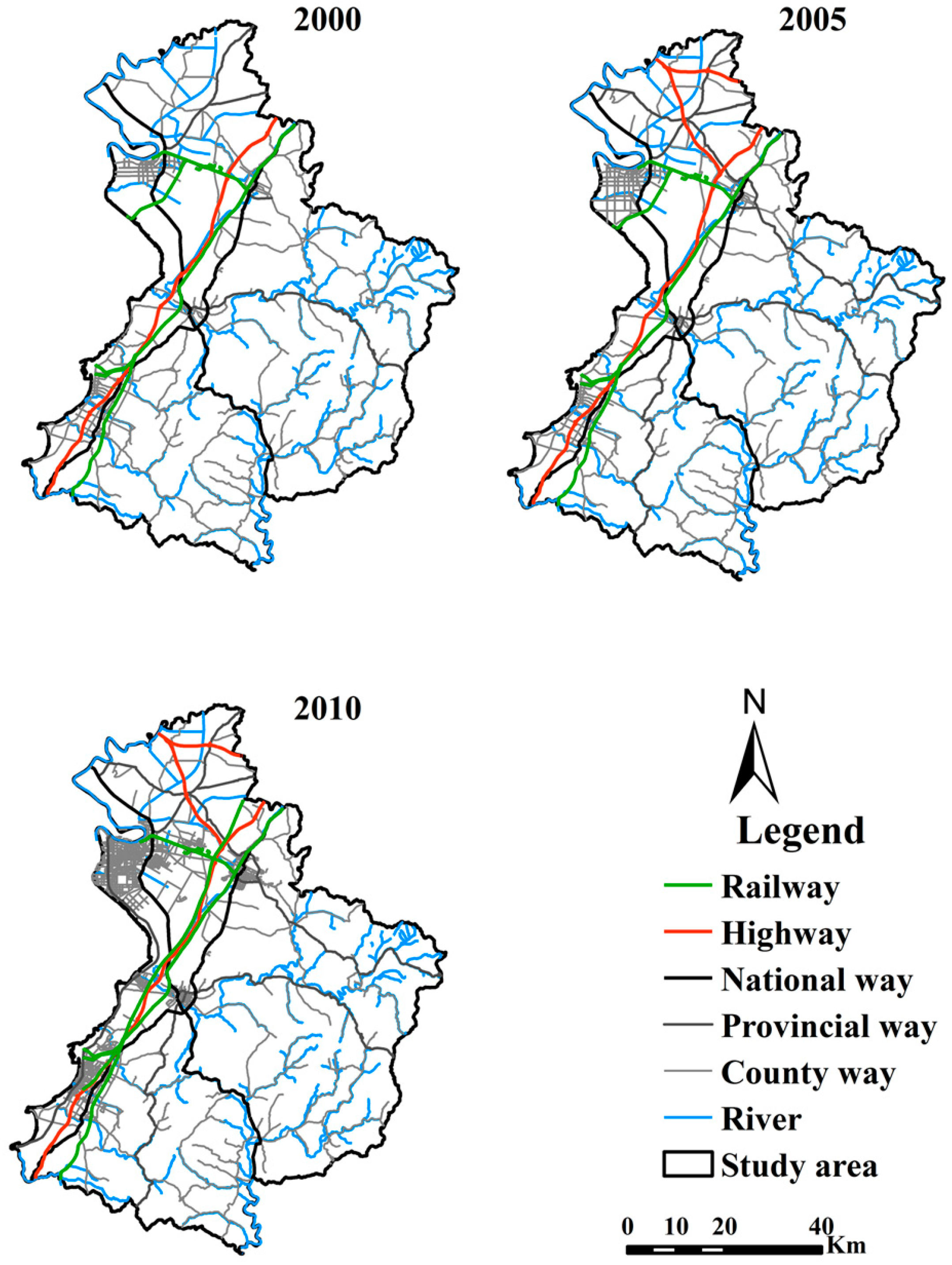
2.2. Data Processing
2.3. Forest Fragmentation Pattern at Landscape Level
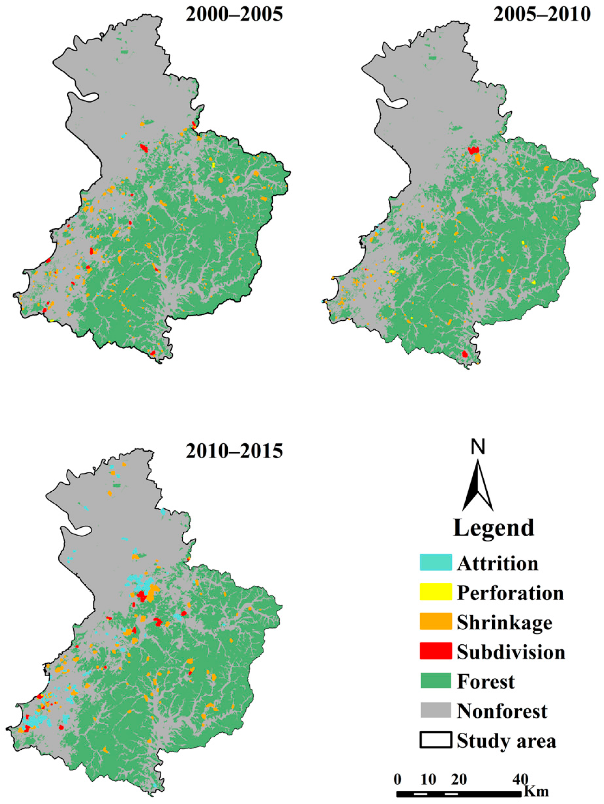
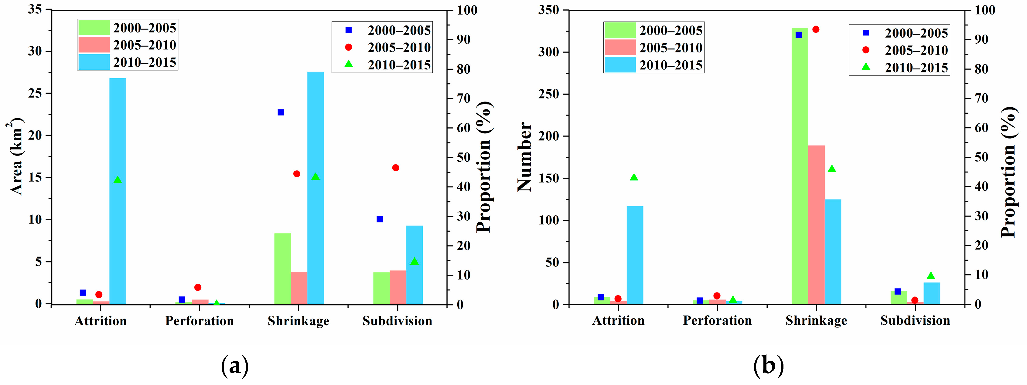
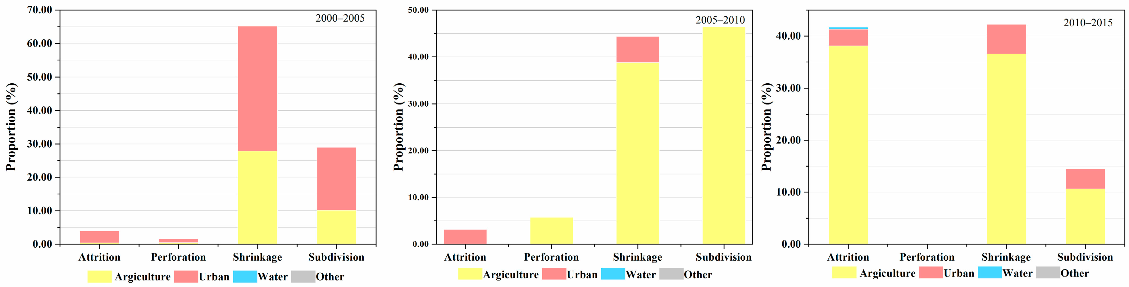
2.4. Forest Fragmentation Processes at Pixel Level
2.5. Driving Factors of Forest Fragmentation
3. Results
3.1. Forest Change
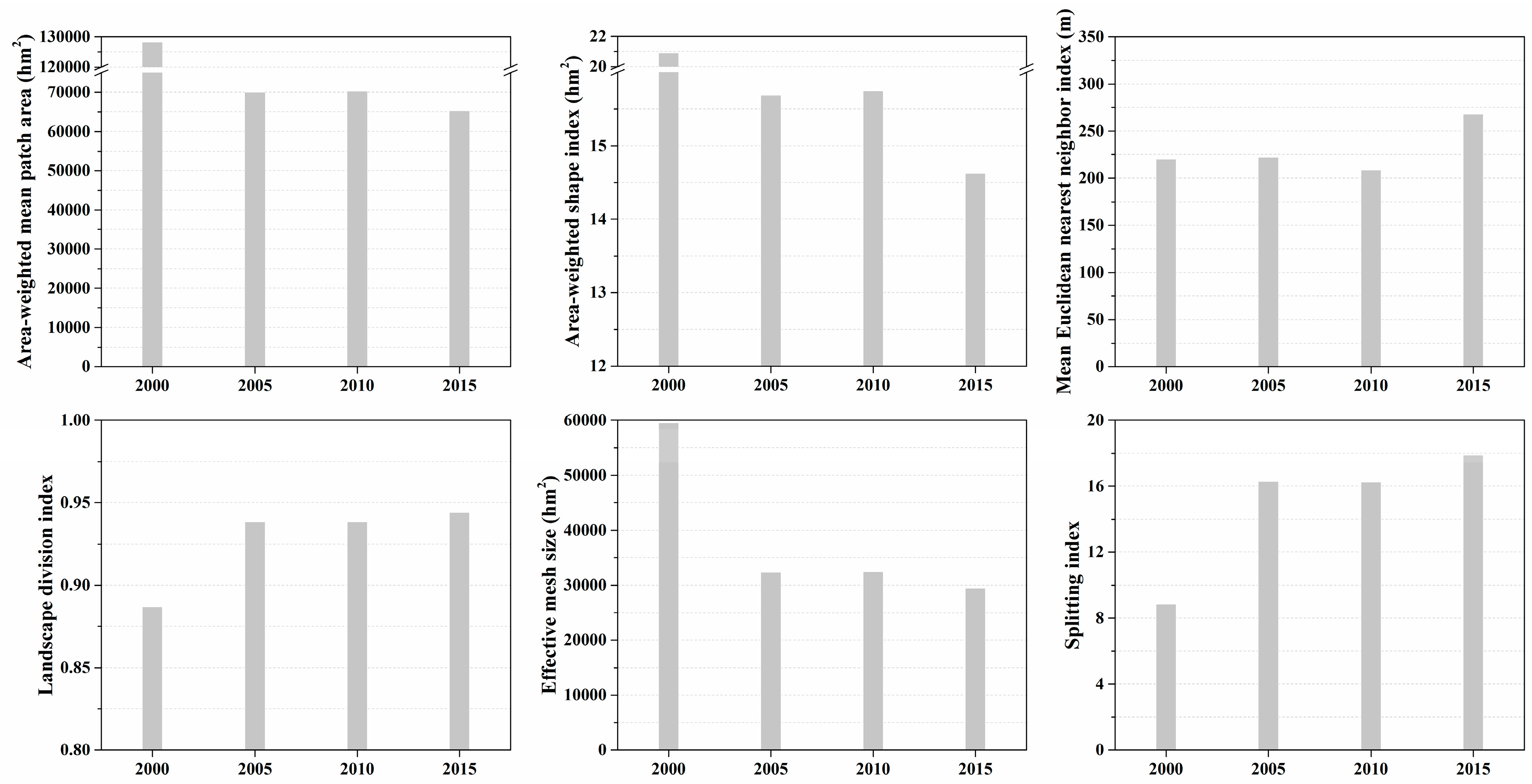
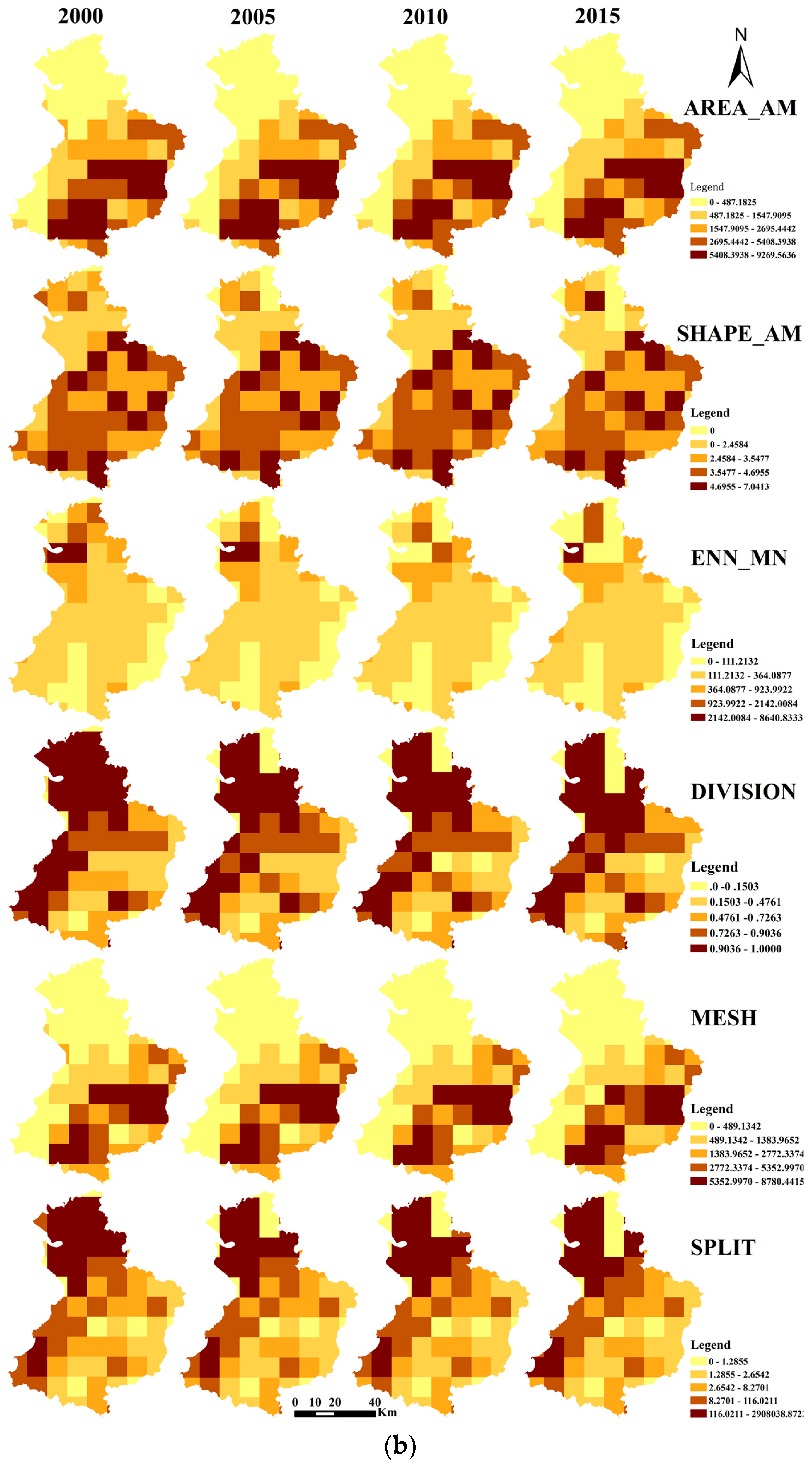
3.2. Forest Fragmentation Pattern at Landscape Level
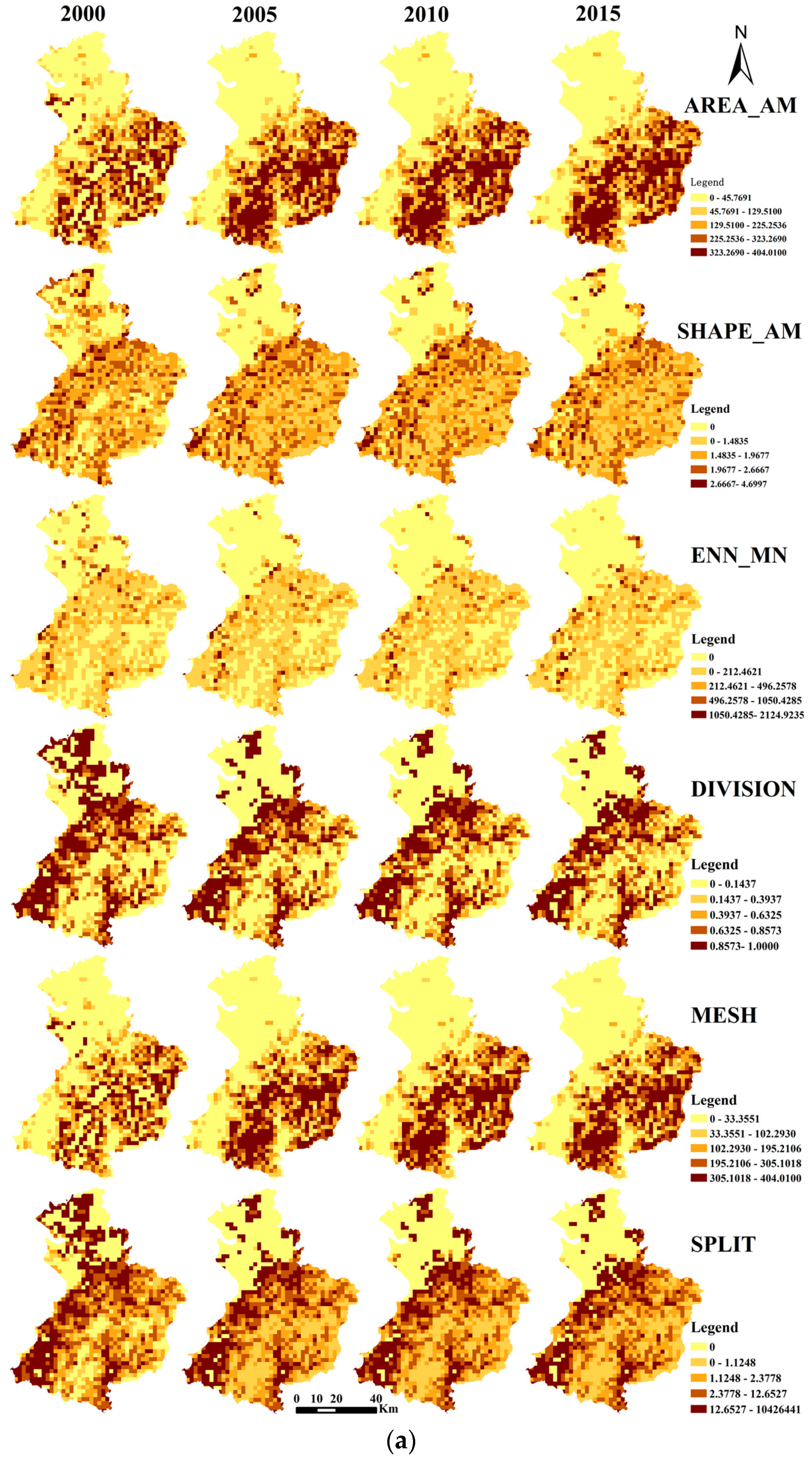
3.3. Forest Fragmentation Processes at Pixel Level
3.4. Driving Factors of Forest Fragmentation
4. Discussion
4.1. Forest Fragmentation and Land Use/Cover Change
4.2. Driving Factors of Landscape Fragmentation
4.3. Recommendations for Forest Protection
4.4. Limitations and Further Studies
5. Conclusions
Acknowledgments
Author Contributions
Conflicts of Interest
Appendix A. Distributions of Forest Fragmentation in 2000, 2005, 2010 and 2015 at 2 km Scale and 10 km Scale


References
- FAO. State of the World’s Forests 2016: Forests and Agriculture—Land Use Challenges and Opportunities; Food and Agriculture Organization of the United Nations: Rome, Italy, 2016. [Google Scholar]
- Lele, N.; Joshi, P.K.; Agrawal, S.P. Assessing forest fragmentation in northeastern region (NER) of India using landscape matrices. Ecol. Indic. 2008, 8, 657–663. [Google Scholar] [CrossRef]
- Wickham, J.D.; Riitters, K.H.; Wade, T.G.; Homer, C. Temporal change in fragmentation of continental US forests. Landsc. Ecol. 2008, 23, 891–898. [Google Scholar] [CrossRef]
- Gao, J.; Liu, Y. Deforestation in Heilongjiang province of China, 1896–2000: Severity, spatiotemporal patterns and causes. Appl. Geogr. 2012, 35, 345–352. [Google Scholar] [CrossRef]
- Fahrig, L. Effects of habitat fragmentation on biodiversity. Annu. Rev. Ecol. Evol. Syst. 2003, 34, 487–515. [Google Scholar] [CrossRef]
- DeFries, R.S.; Asner, G.P.; Houghton, R. Trade-offs in land-use decisions: Towards a framework for assessing multiple ecosystem responses to land-use change. In Ecosystems and Land Use Change; American Geophysical Union: Washington, DC, USA, 2013; pp. 1–9. [Google Scholar]
- Echeverria, C.; Coomes, D.A.; Hall, M.; Newton, A.C. Spatially explicit models to analyze forest loss and fragmentation between 1976 and 2020 in southern Chile. Ecol. Model. 2008, 212, 439–449. [Google Scholar] [CrossRef]
- Saunders, D.A.; Hobbs, R.J.; Margules, C.R. Biological consequences of ecosystem fragmentation: A review. Conserv. Biol. 1991, 5, 18–32. [Google Scholar] [CrossRef]
- Li, M.; Mao, L.; Zhou, C.; Vogelmann, J.E.; Zhu, Z. Comparing forest fragmentation and its drivers in China and the USA with Globcover v2.2. J. Environ. Manag. 2010, 91, 2572–2580. [Google Scholar] [CrossRef] [PubMed]
- Li, H.; Franklin, J.F.; Swanson, F.J.; Spies, T.A. Developing alternative forest cutting patterns: A simulation approach. Landsc. Ecol. 1993, 8, 63–75. [Google Scholar] [CrossRef]
- Franklin, J.F.; Forman, R.T.T. Creating landscape patterns by forest cutting: Ecological consequences and principles. Landsc. Ecol. 1987, 1, 5–18. [Google Scholar] [CrossRef]
- Harris, L.D. The Fragmented Forest: Island Biogeography Theory and the Preservation of Biotic Diversity; University of Chicago Press: Chicago, IL, USA, 1984. [Google Scholar]
- Collinge, S.K. Spatial arrangement of habitat patches and corridors: Clues from ecological field experiments. Landsc. Urban Plan. 1998, 42, 157–168. [Google Scholar] [CrossRef]
- Liu, Y.; Feng, Y.; Zhao, Z.; Zhang, Q.; Su, S. Socioeconomic drivers of forest loss and fragmentation: A comparison between different land use planning schemes and policy implications. Land Use Policy 2016, 54, 58–68. [Google Scholar] [CrossRef]
- Jaeger, J.A.G. Landscape division, splitting index, and effective mesh size: New measures of landscape fragmentation. Landsc. Ecol. 2000, 15, 115–130. [Google Scholar] [CrossRef]
- Girvetz, E.H.; Thorne, J.H.; Berry, A.M.; Jaeger, J.A.G. Integration of landscape fragmentation analysis into regional planning: A statewide multi-scale case study from California, USA. Landsc. Urban Plan. 2008, 86, 205–218. [Google Scholar] [CrossRef]
- Onojeghuo, A.O.; Blackburn, G.A. Forest transition in an ecologically important region: Patterns and causes for landscape dynamics in the Niger Delta. Ecol. Indic. 2011, 11, 1437–1446. [Google Scholar] [CrossRef]
- Forman, R.T. Land Mosaics: The Ecology of Landscapes and Regions; Cambridge University Press: Cambridge, NY, USA, 1995. [Google Scholar]
- Collinge, S.K.; Forman, R.T.T. A conceptual model of land conversion processes: Predictions and evidence from a microlandscape experiment with grassland insects. Oikos 1998, 82, 66–84. [Google Scholar] [CrossRef]
- Li, S.; Yang, B. Introducing a new method for assessing spatially explicit processes of landscape fragmentation. Ecol. Indic. 2015, 56, 116–124. [Google Scholar] [CrossRef]
- Riitters, K.; Wickham, J.; O’Neill, R.; Jones, B.; Smith, E. Global-scale patterns of forest fragmentation. Conserv. Ecol. 2000, 4, 3. [Google Scholar] [CrossRef]
- Jiang, P.; Cheng, L.; Li, M.; Zhao, R.; Huang, Q. Analysis of landscape fragmentation processes and driving forces in wetlands in arid areas: A case study of the middle reaches of the Heihe River, China. Ecol. Indic. 2014, 46, 240–252. [Google Scholar] [CrossRef]
- Gong, C.; Yu, S.; Joesting, H.; Chen, J. Determining socioeconomic drivers of urban forest fragmentation with historical remote sensing images. Landsc. Urban Plan. 2013, 117, 57–65. [Google Scholar] [CrossRef]
- Su, S.; Wang, Y.; Luo, F.; Mai, G.; Pu, J. Peri-urban vegetated landscape pattern changes in relation to socioeconomic development. Ecol. Indic. 2014, 46, 477–486. [Google Scholar] [CrossRef]
- Cai, X.; Wu, Z.; Cheng, J. Using kernel density estimation to assess the spatial pattern of road density and its impact on landscape fragmentation. Int. J. Geogr. Inf. Sci. 2013, 27, 222–230. [Google Scholar] [CrossRef]
- Karlson, M.; Mörtberg, U. A spatial ecological assessment of fragmentation and disturbance effects of the Swedish road network. Landsc. Urban Plan. 2015, 134, 53–65. [Google Scholar] [CrossRef]
- Forman, R.T.; Deblinger, R.D. The ecological road-effect zone of a Massachusetts (USA) suburban highway. Conserv. Biol. 2000, 14, 36–46. [Google Scholar] [CrossRef]
- Liu, S.; Dong, Y.; Deng, L.; Liu, Q.; Zhao, H.; Dong, S. Forest fragmentation and landscape connectivity change associated with road network extension and city expansion: A case study in the Lancang River Valley. Ecol. Indic. 2014, 36, 160–168. [Google Scholar] [CrossRef]
- Greenberg, J.A.; Kefauver, S.C.; Stimson, H.C.; Yeaton, C.J.; Ustin, S.L. Survival analysis of a neotropical rainforest using multitemporal satellite imagery. Remote Sens. Environ. 2005, 96, 202–211. [Google Scholar] [CrossRef]
- Yu, D.; Zhou, L.; Zhou, W.; Ding, H.; Wang, Q.; Wang, Y.; Wu, X.; Dai, L. Forest management in Northeast China: History, problems, and challenges. Environ. Manag. 2011, 48, 1122–1135. [Google Scholar] [CrossRef] [PubMed]
- Van Den Hoek, J.; Ozdogan, M.; Burnicki, A.; Zhu, A.X. Evaluating forest policy implementation effectiveness with a cross-scale remote sensing analysis in a priority conservation area of Southwest China. Appl. Geogr. 2014, 47, 177–189. [Google Scholar] [CrossRef]
- The Geospatial Data Cloud site, Computer Network Information Center, Chinese Academy of Sciences. Available online: http://www.gscloud.cn (accessed on 2 March 2017).
- Zhang, Z.; Li, A.; Lei, G.; Bian, J.; Wu, B. Change detection of remote sensing images based on multiscale segmentation and decision tree algorithm over mountainous area: A case study in Panxi region, Sichuan Province. Acta Ecol. Sin. 2014, 34, 7222–7232. [Google Scholar]
- Data Center for Resources and Environmental Sciences, Chinese Academy of Sciences. Available online: http://www.resdc.cn (accessed on 2 March 2017).
- Anselin, L. Exploring Spatial Data with GeoDa: A Workbook; Center for Spatially Integrated Social Science: Santa Barbara, CA, USA, 2005. [Google Scholar]
- Tan, R.; Liu, Y.; Liu, Y.; He, Q.; Ming, L.; Tang, S. Urban growth and its determinants across the Wuhan urban agglomeration, central China. Habitat Int. 2014, 44, 268–281. [Google Scholar] [CrossRef]
- Anselin, L. Spatial Econometrics: Methods and Models; Kluwer Academic Publishers: London, UK, 1988; pp. 310–330. [Google Scholar]
- Ye, X.; Wu, L. Analyzing the dynamics of homicide patterns in Chicago: ESDA and spatial panel approaches. Appl. Geogr. 2011, 31, 800–807. [Google Scholar] [CrossRef]
- Foley, J.A.; DeFries, R.; Asner, G.P.; Barford, C.; Bonan, G.; Carpenter, S.R.; Chapin, F.S.; Coe, M.T.; Daily, G.C.; Gibbs, H.K.; et al. Global consequences of land use. Science 2005, 309, 570–574. [Google Scholar] [CrossRef] [PubMed]
- Abdullah, S.A.; Nakagoshi, N. Forest fragmentation and its correlation to human land use change in the state of Selangor, peninsular Malaysia. For. Ecol. Manag. 2007, 241, 39–48. [Google Scholar] [CrossRef]
- Fuller, D.O. Forest fragmentation in Loudoun County, Virginia, USA evaluated with multitemporal Landsat imagery. Landsc. Ecol. 2001, 16, 627–642. [Google Scholar] [CrossRef]
- Jin, J.; Wang, Y.; Jiang, H.; Cheng, M. Recent NDVI-based variation in growth of Boreal intact forest landscapes and its correlation with climatic variables. Sustainability 2016, 8, 326. [Google Scholar] [CrossRef]


| 2000 | 2005 | 2010 | 2015 | |||||
|---|---|---|---|---|---|---|---|---|
| Area (km2) | Proportion (%) | Area (km2) | Proportion (%) | Area (km2) | Proportion (%) | Area (km2) | Proportion (%) | |
| Forest | 1716.78 | 32.54 | 1680.50 | 31.86 | 1649.79 | 31.27 | 1643.44 | 31.15 |
| Cropland | 2450.11 | 46.45 | 2439.69 | 46.25 | 2436.86 | 46.20 | 2381.98 | 45.15 |
| Urban | 656.49 | 12.45 | 699.51 | 13.26 | 792.46 | 15.02 | 900.94 | 17.08 |
| Water | 359.13 | 6.81 | 363.35 | 6.89 | 299.33 | 5.67 | 262.12 | 4.97 |
| Other land | 92.62 | 1.76 | 92.08 | 1.75 | 96.69 | 1.83 | 86.65 | 1.64 |
| Total | 5275.13 | 100.00 | 5275.13 | 100.00 | 5275.13 | 100.00 | 5275.13 | 100.00 |
| Increased Amount (km2) | Increased Rate (%) | Decreased Amount (km2) | Decreased Rate (%) | Gross Change Rate (%) | |
|---|---|---|---|---|---|
| 2000–2005 | 2.35 | 0.02 | 12.77 | 0.10 | 0.12 |
| 2005–2010 | 6.92 | 0.06 | 9.75 | 0.08 | 0.14 |
| 2010–2015 | 9.41 | 0.08 | 64.29 | 0.53 | 0.61 |
| Area-weighted mean patch area | Area-weighted shape index | Effective mesh size | ||||||||||
|---|---|---|---|---|---|---|---|---|---|---|---|---|
| Variable | 2000 b | 2005 b | 2010 b | 2015 b | 2000 b | 2005 b | 2010 b | 2015 b | 2000 b | 2005 b | 2010 b | 2015 b |
| Constant | 0.5262 ** | −0.0087 * | −0.0086 | |||||||||
| Elevation | −0.3928 ** | −0.3654 ** | −0.3674 ** | −0.3693 ** | −0.1877 ** | −0.1917 ** | −0.2214 ** | −0.2293 ** | −0.3928 ** | −0.3654 ** | −0.3674 ** | −0.3693 ** |
| Slope | 0.4212 ** | 0.3938 ** | 0.3941 ** | 0.3977 ** | 0.2346 ** | 0.2535 ** | 0.2839 ** | 0.2844 ** | 0.4212 ** | 0.3938 | 0.3941 ** | 0.3977 ** |
| Dis_C | 0.5018 ** | 0.162412 * | 1.5177 ** | 0.4749 ** | 0.7183 ** | 0.569 ** | 0.5015 ** | 0.1624 ** | ||||
| Dis_T | −0.2069 ** | −0.2501 ** | −0.2641 ** | |||||||||
| Dis_Rail | 0.2945 ** | −0.9118 ** | 1.047 ** | 1.673 ** | 0.3183 ** | 0.2945 ** | ||||||
| Dis_H | −1.3239 ** | −1.851 ** | ||||||||||
| Dis_N | 0.0622 * | 0.1542 ** | 0.0622 * | |||||||||
| Dis_P | −0.3725 ** | −0.3016 ** | −0.2760 ** | −0.3388 ** | −0.8173 ** | −0.295 ** | −0.3446 * | −0.3725 ** | −0.276 ** | −0.3388 ** | ||
| Dis_X | −0.1735 ** | −0.1798 ** | −0.1764 ** | −0.155 * | ||||||||
| Dis_Riv | 0.1370 ** | 0.1661 ** | 0.2047 ** | 0.1599 * | ||||||||
| GDP | −0.0672 ** | −0.0669 ** | −0.0224 | −0.0462 * | −0.1008 ** | −0.1073 * | −0.0931 ** | −0.0071 ** | −0.0672 ** | |||
| W | 0.6515 | 0.673 | 0.6669 | 0.6608 | 0.5851 | 0.6001 | 0.5804 | 0.5632 | 0.6515 | 0.673 | 0.6669 | 0.6608 |
| R2 | 0.6629 | 0.6577 | 0.6573 | 0.656 | 0.5731 | 0.5708 | 0.5818 | 0.5451 | 0.6629 | 0.6577 | 0.6573 | 0.656 |
| AIC | 2775.41 | 2813.89 | 2810.65 | 2811.97 | 3076.33 | 2654.41 | 3043.74 | 3156.4 | 2775.41 | 2813.89 | 2810.65 | 2811.97 |
| Area-weighted mean patch area | Area-weighted shape index | Effective mesh size | Mean Euclidean nearest neighbor index | |||||||||||
|---|---|---|---|---|---|---|---|---|---|---|---|---|---|---|
| Variable | 2000 b | 2005 a | 2010 b | 2015 b | 2000 a | 2005 a | 2010 a | 2015 b | 2000 b | 2005 a | 2010 b | 2015 b | 2000 b | 2015 b |
| Elevation | −1.6355 * | −1.6887 * | −2.4238 ** | −2.7074 ** | −2.8885 ** | −1.6355 * | −1.6148 * | −1.6887 * | ||||||
| Slope | 1.5122 * | 1.5466 * | 1.9589 ** | 2.3185 ** | 2.4199 ** | 1.5122* | 1.5465 * | |||||||
| Dis_C | 1.3107 * | 2.4826 ** | 0.7326 * | 0.6655 * | 1.3107 * | |||||||||
| Dis_Rail | 1.1288 ** | −2.1986 ** | 0.8614 * | 1.1288 ** | ||||||||||
| Dis_H | 1.9233 * | |||||||||||||
| Dis_P | −0.9246 * | −0.6310 ** | −0.7358 ** | −0.8447 ** | −1.4784 ** | −0.5225 * | −0.7197 * | −0.6391 * | −0.9246 * | −0.631 ** | −0.7358 ** | −0.8447 ** | ||
| POP | 0.5546 ** | |||||||||||||
| GDP | −0.2442 * | 0.2757 ** | ||||||||||||
| W/λ | 0.4681 | 0.5402 | 0.5119 | 0.4378 | 0.3161 | 0.3334 | 0.2525 | 0.2282 | 0.4681 | 0.5402 | 0.5119 | 0.4378 | 0.4625 | 0.5633 |
| R2 | 0.5503 | 0.5458 | 0.5478 | 0.5114 | 0.4916 | 0.4863 | 0.4815 | 0.5089 | 0.5503 | 0.5458 | 0.5478 | 0.5114 | 0.5693 | 0.4742 |
| AIC | 185.82 | 186.82 | 187.549 | 191.239 | 189.655 | 190.724 | 190.171 | 187.806 | 185.826 | 186.82 | 187.549 | 191.239 | 182.419 | 194.925 |
© 2017 by the authors. Licensee MDPI, Basel, Switzerland. This article is an open access article distributed under the terms and conditions of the Creative Commons Attribution (CC BY) license ( http://creativecommons.org/licenses/by/4.0/).
Share and Cite
Zhang, L.; Liu, Y.; Wei, X. Forest Fragmentation and Driving Forces in Yingkou, Northeastern China. Sustainability 2017, 9, 374. https://doi.org/10.3390/su9030374
Zhang L, Liu Y, Wei X. Forest Fragmentation and Driving Forces in Yingkou, Northeastern China. Sustainability. 2017; 9(3):374. https://doi.org/10.3390/su9030374
Chicago/Turabian StyleZhang, Lei, Yanfang Liu, and Xiaojian Wei. 2017. "Forest Fragmentation and Driving Forces in Yingkou, Northeastern China" Sustainability 9, no. 3: 374. https://doi.org/10.3390/su9030374