Article

Coastal Forests and Groundwater: Using Case Studies to Understand the Effects of Drivers and Stressors for Resource Management

by
Timothy J. Callahan
1,*,
Devendra M. Amatya
2 and
Peter A. Stone
3
1
Department of Geology and Environmental Geosciences, College of Charleston, 66 George Street, Charleston, SC 29424, USA
2
U.S. Department of Agriculture Forest Service, Center for Forested Wetlands Research, Cordesville, SC 29434, USA
3
South Carolina Department of Health and Environmental Control, Columbia, SC 29201, USA
*
Author to whom correspondence should be addressed.
Sustainability 2017, 9(3), 447; https://doi.org/10.3390/su9030447
Submission received: 28 November 2016 / Revised: 27 February 2017 / Accepted: 15 March 2017 / Published: 18 March 2017

Abstract

:
Forests are receiving more attention for the ecosystem goods and services they provide and the potential change agents that may affect forest health and productivity. Highlighting case examples from coastal forests in South Carolina, USA, we describe groundwater processes with respect to stressors and potential responses of a wetland-rich forested landscape, the roles that this area has served, and the need for water resource data to inform forest management decisions. Forested lands in the southeastern U.S. coastal plain provide a rich set of goods and services for the region, and in one case, the Francis Marion National Forest acts as a buffer to urbanization from the surrounding Charleston metropolitan area. Information from two decades of studies in the forested watersheds there may inform scientists and managers in other coastal forested systems. The common hydrological theme in this region, which has a higher average annual rainfall (1370 mm) than the annual potential evapotranspiration (PET = 1135 mm), is a shallow (<3 m) water table condition that supports a large range of natural wetlands and also creates management challenges across the region. Modest changes in the position of the water table can lead to either groundwater flooding and concomitant management challenges for forest services, or ecosystem stresses related to dry conditions in wetlands during times of below-normal precipitation or due to groundwater withdrawal. Development pressures have also stressed forest resources through the extraction of materials such as timber and sand mining, and the conversion to housing construction materials. These areas are also targeted for land development, to meet housing demands. In this paper, we discuss the role of groundwater in coastal forests and highlight opportunities for collaborative studies to better inform forest resource management.

1. Introduction

It is critically important to protect natural resources such as forest lands for their inherent value, as well as the goods and services they provide [1]. Land use change due to development, in response to population growth and climate change stressors, are affecting the health and productivity of forest lands. Forests serve a significant proportion of the world’s population (Figure 1) by providing potable water storage (through infiltration to groundwater reservoirs) and water quality buffering (through wetland filtration). Forests cover approximately 26.2% of the world’s surface, with 45.7% of Latin America and the Caribbean being covered, 35% of East Asia and the Pacific, and 35% of the European Union. North American forests (data for Canada and the United States combined) account for only 6.8% of the world’s forests, while Africa boasts a figure of 5.7% [2]. Although the wide distribution of forests worldwide makes it difficult to generalize about the role of trees and forest ecosystems in the global hydrologic cycle [3], it is estimated that 30% of global forests have been cleared and about 20% have been degraded in some way [4]. One-third of drinking water resources for the world’s largest cities are provided by forested lands [5]. Furthermore, a large fraction of the global population lives in coastal areas, and significant growth is expected in the future [6]. For example, the Charleston suburb of Mount Pleasant, South Carolina, was the fastest-growing coastal city in the eastern United States in 2015, gaining 10,000 new residents since 2011 and resulting in a total population of more than 78,000 [7]. Adjacent to this suburb, bordering the eastern part of the growing Charleston metropolitan region, is an important forested area, the Francis Marion National Forest (FMNF; Figure 2), a federal area managed by the U.S. Department of Agriculture-Forest Service [8] on the southeastern Atlantic coastal plain (latitude and longitude: 33.131, −79.783). It is comprised of 1000 km2 of forest stands of pine (Pinus spp., mostly loblolly (P. taeda), with some stands of longleaf (P. palustris) and slash pine (P. elliotti)) and hardwood tree species, the majority of which are oak (Quercus spp.). The FMNF has approximately 56% hydric soils [9]; hydric soil is defined as having formed under conditions of saturation, flooding, or ponding long enough during the growing season to develop anaerobic conditions in the upper part [10]. Many of these areas exist as wetland systems and include freshwater and saltwater marshes, freshwater swamps, geographically-isolated wetlands, and riparian zones of small-scale streams and creeks, many of which are ephemeral or intermittent in flow; the wet season in an average year is the non-growing (winter) months of December–February. Since settlement in the U.S., it has been estimated that about 50% of wetlands have been lost [11], and many of them have been converted in the last several decades, primarily as a result of urbanization and agricultural activities [12,13,14]. Elsewhere, since the 1960s, more than 50% of the mangrove wetlands in Southeast Asia have been lost, mainly due to the direct and indirect impacts of development [15]. While in certain locations more modern forest management practices have considered the value of ecosystem goods and services, including watershed services such as water supply, water quality preservation, and soil formation and stabilization [16], timber supply remains an important forest resource [17].
In the United States, the USDA-Forest Service specifically recognizes the importance and vulnerability of groundwater-dependent ecosystems, and recognizes the diversity found in their direct relationships to the water table [17,18]. Groundwater-dependent ecosystems (GDEs) are vital yet poorly understood components of the natural environment and are defined as terrestrial, aquatic, and coastal ecosystems that require access to, replenishment, benefit from, or rely on the subsurface storage of water to function or persist [19]. Areas with a relatively shallow water table are environments where groundwater plays a key role in ecosystem functions and important interactions exist between hydrology and ecosystem processes [20]. In GDEs, interactions between rainfall, water table fluctuations, and vegetation are reflected through the soil water content [21,22]. Managers of lands with shallow water table conditions recognize the need for a better ecological understanding of these systems, in the full sweep from biology to hydrology [18,19]. In a recent examination of the hydrology of forested areas subject to soil saturation by precipitation, groundwater, or surface flooding, it was noted that precipitation may be the major cause of water surplus for sites on nearly level areas and concave landscapes may generally be influenced by both the precipitation and groundwater regimes, with the length of flooding depending upon aquifer storage characteristics [23] and being generally dominated by surface runoff [24]. This knowledge is needed because such systems are especially prone to shifting across ecological thresholds, even under relatively minor shifts in hydrology. Figure 3 is the U.S. National Wetlands Inventory map for the Francis Marion National Forest and surrounding region, which shows the widespread condition of depressional wetlands and a landscape with a shallow water position.
The hydrology of the southeastern U.S. coastal plain is complex. Over its geological history, riverine, palustrine, and estuarine environments have been produced at or near the coastal boundary, with several natural lacustrine systems, as well as recent engineered reservoirs and canals, having been developed for various uses [27]. Surface hydrology is complex in the low gradient terrain of the lower coastal plain due to a series of beach, back-barrier, river, and swamp depositional facies that influence the surface topography. The coastal plain of the southeastern U.S. contains a substantial diversity of wet to damp habitats, such as frequently-inundated swamps (both riverine and nonriverine), seasonally-inundated wetlands, and shallow water table conditions, yet only occasionally flooded forests in the uplands of pine stands [18,19,26,27]. Approximately 45% of the FMNF are riparian or wetland systems with bottomland hardwood species such as bald cypress (Taxodium distichum) and pond cypress (T. ascendens), blackgum (Nyssa sylvatica), water or swamp tupelo (N. aquatica), pond pine (P. serotina), red maple (Acer rubrum), and sweetgum (Liquidambar spp.) [25]. There are also perennially wet locations adjacent to streams, and at least one significant spring mouth (Blue Spring, Echaw Creek, Berkeley County, SC, USA) was found during an investigation for potential GDE sites in the FMNF [28], in addition to at least one of the deeper partially-infilled solution depressions. While most of these features receive direct rainfall or shallow surface runoff from adjacent uplands, the presence of a shallow water table in this landscape, where the long-term average annual precipitation (1370 mm) is higher than the long-term annual potential evapotranspiration (PET = 1135 mm) [29], facilitates the formation of excess saturated soil conditions, on average, during and after rainy periods. The shallow water table in these systems is the surficial aquifer, in which undifferentiated fine-grained sands of the Pleistocene Epoch (Wando Formation and Silver Bluff beds) are deposited on semi-consolidated marine sediments in coastal South Carolina of the Chicora Member of the Williamsburg Formation (also known as the Santee Limestone) of the late Paleocene [30,31]. See Figure A1 for an idealized geological cross-section of this region.
Unlike many wetlands in arid or semiarid climates such as the American west, that are focused around river systems, the water table in the southeastern U.S. coastal plain supports widespread wetlands and can induce saturated soils within upland forest stands during wet periods. An ephemeral stream channel or prairie-pothole wetland in arid to semi-arid climates may flood, even if the principal water table lies far below it, and those systems may be sensitive to changes in weather, but less so to alterations in regional aquifer water elevations [32,33]. In shallow water table settings, however, seemingly small changes in the water budget of the groundwater system may cause large changes in the surface hydrology, such as surface runoff, wetland water content, and groundwater discharge as baseflow to streams and rivers [23,34]. Figure 4 shows a conceptual diagram that illustrates how changing the water table position may affect a riparian zone or depression wetland [35]. Based on field visits, interpretations of geological surveys [31,36,37], and water-level data from piezometers in the region (Figure 2) [26,38], we estimate that, for the most part, this area does not have truly perched groundwater conditions and thus downward drainage is not limited geologically, but rather by the small downward hydraulic gradients in this flat, highwater-table landscape. Considering an example site with a shallow water-table, if there is an annual one meter water table fluctuation and then a relatively sudden half-meter decrease in the water table elevation due to groundwater withdrawal or tree harvesting, the relative impacts on the vegetation and habitat may be larger than in locations where the average water table is significantly deeper (>3 m). Even in settings of thick (>3 m) sequences of highly permeable sediments (former beach sands), the groundwater regime—via a shallow water table—holds the soils at large volumetric water content conditions, even in drier seasons. The sandy-loam texture of the soils and sediments is also an important factor. Some cases in point are studies of the water table response in three locations in the coastal plain region [26,39], and data have indicated that the specific yield of the surficial aquifer sediments was 0.1 or less, such that 5 mm of water loss by evapotranspiration (ET) can cause the water table depth to drop by at least 5 cm [40,41,42]. A comparable study in a drier climate, that used water table hydrograph data to understand groundwater recharge, found that the management of eucalypt stands in Australia can affect the water balance, but that the landscape position in that region was more important [32,33]. Many tectonically-passive coastal regions like the southern and southeastern U.S. face widespread impacts of water imbalances because of the generally flat topography. Also, the pumping of a hydrologically-connected deeper aquifer could shift surface- or soil-wetness conditions across subtle ecological thresholds (Figure 4), and a minimal topographic gradient would potentially have a larger areal effect. Low-relief areas with seasonal wetlands can be susceptible to vegetation changes under even minor shifts in hydrological conditions, due to climate- or human-induced conditions from groundwater pumping [23,43] (Figure 5).
While initial considerations of groundwater-supported ecosystems have been discussed [18,19], it may not be appropriate to develop final local or regional classifications and distinctions from a survey guide. Such guiding documents can initially be used to assess and identify project-level design and mitigation measures for a specific set of GDE types, as well as the major physical and biological characteristics (geological setting, vegetation, soil, hydrology, and terrestrial and aquatic fauna). However, important local differences may exist. For example, rain-derived soil water or shallow groundwater may in fact be minerotrophic here, due to the reaction with exposed mineral soils, and cannot simply be considered ombrotrophic because of its origin as rainfall. Studies in southern Australia have identified the role of water-substrate (soil and rock) interactions on the evolution of soil water. Groundwater can be a source and conduit for nutrients derived from soil and rock weathering [44]. In the southeastern U.S., as a part of the development of field guides for managers and scientists [18,19], the FMNF was selected as one of the test locations among several National Forests in the spring of 2010, to better understand the roles of groundwater in forested ecosystems. Preliminary reconnaissance surveys on 15 potential GDE sites and somewhat detailed field surveys on a subset of five GDE sites, including Blue Spring near Echaw Creek, Berkeley County, USA, were conducted [23].
In this study, we outline some key driving factors, potential stressors, and probable risks associated with future hydrological changes, including those due to extreme events [23,45]. Described here is the growing research knowledge on shallow hydrology (below and above the ground surface) in the southeastern U.S. coastal plain and recommendations that such hydrologic linkages and controls need to be further investigated, along with examination of the ecological controls affected by hydrological processes. Example questions for future study are:
  • What is the flooding threshold that influences the upland-wetland boundary, commonly defined in the coastal plain as marked by pine stands and bottomland hardwood species?
  • Is the main factor the maximum ponding depth or the average length of the seasonal flooding, and alternatively, what could be the covariance if both factors are important?
  • How will forest management practices such as the restoration of longleaf pine (P. palustris) insavanna habitats affect the water table dynamics and the water balance in this region?

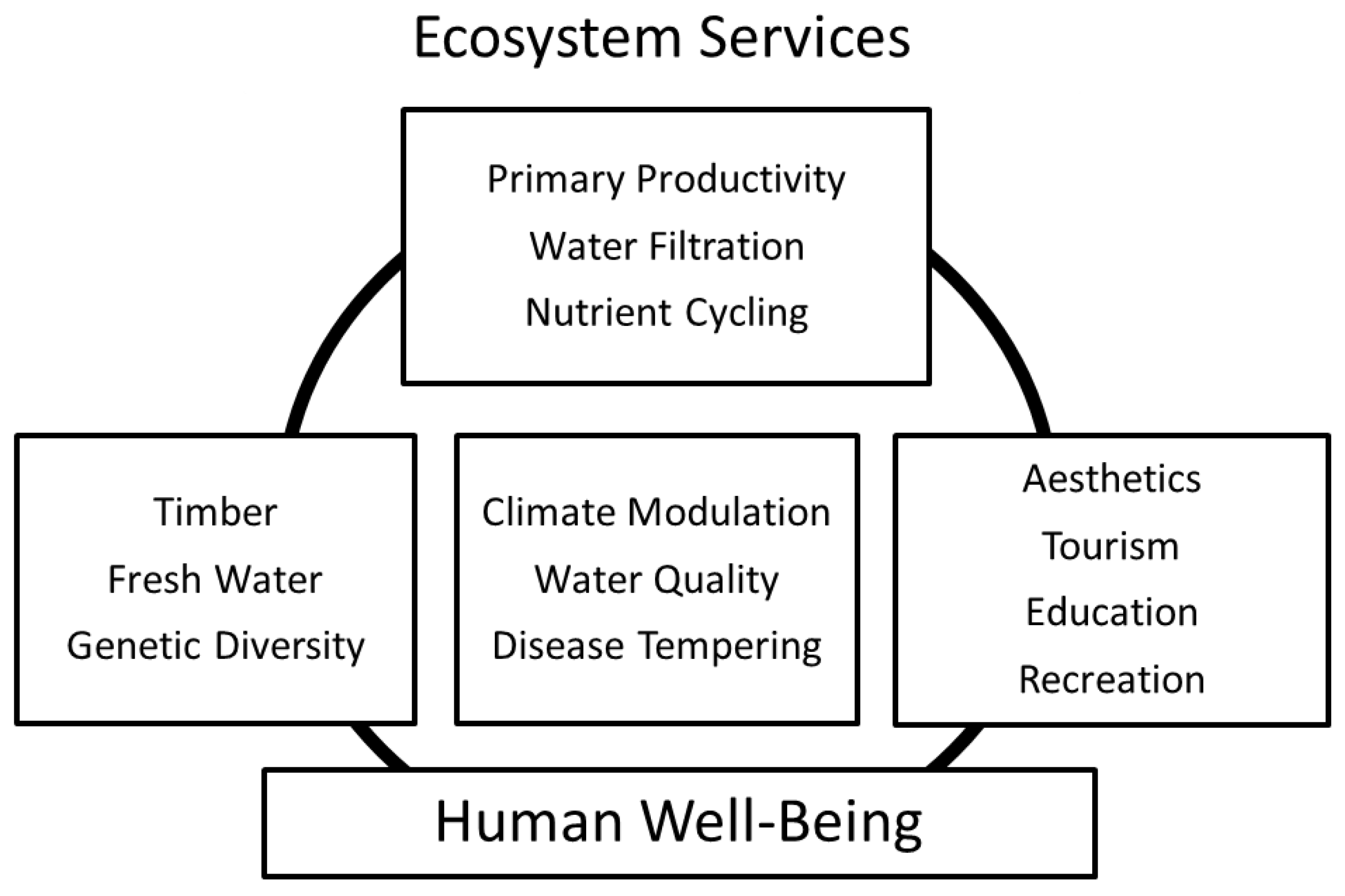
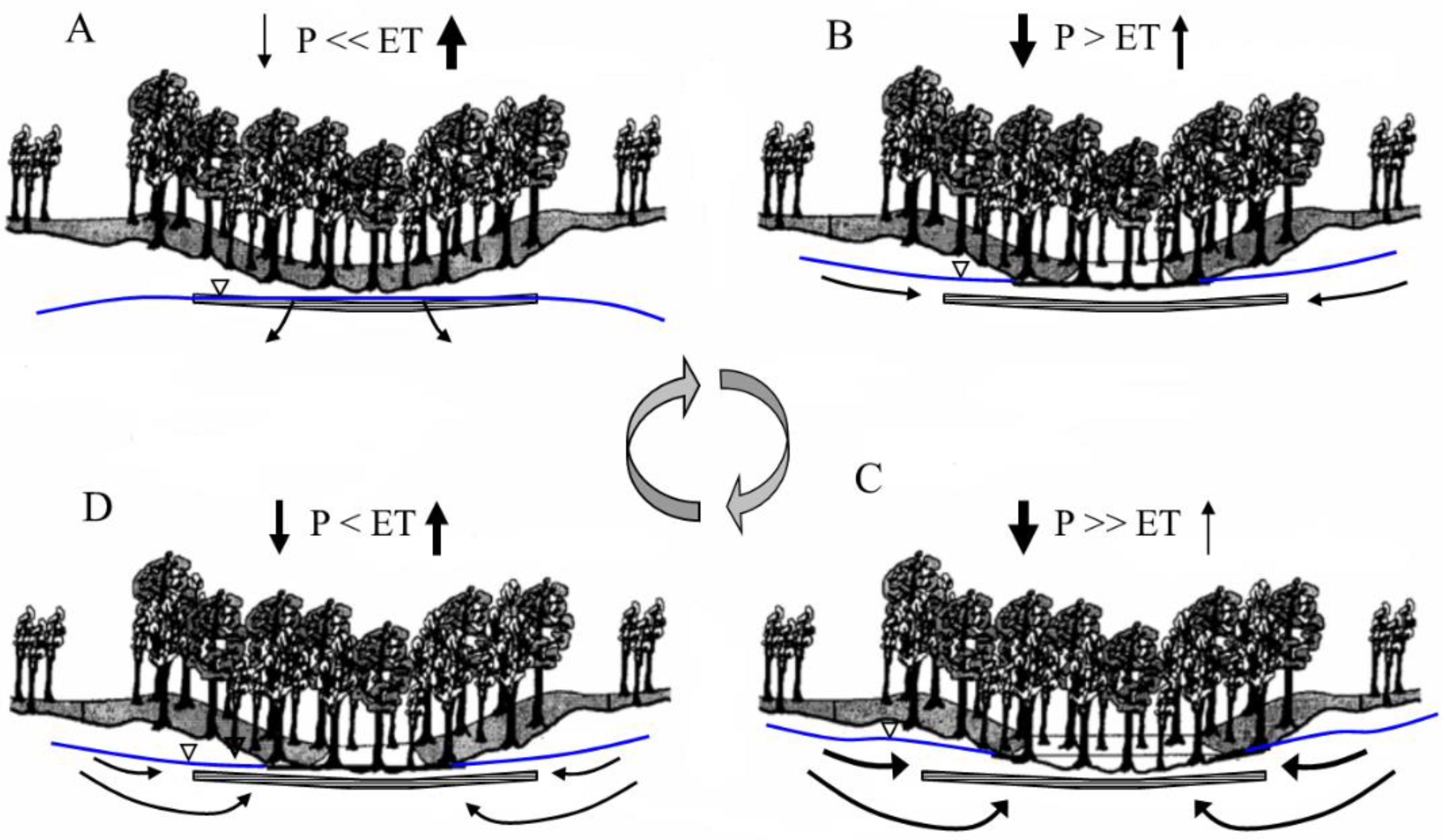
2. The Role of Groundwater as a Driver on Forest Conditions

Development which supports an increased population in the coastal plain will involve an additional demand on water supplies [46] and the deeper, more-confined aquifers may be targeted for water resource developments [5]. Shallow water table aquifers are not sustainable as large-scale water reservoirs, but these near-surface systems play an important role in supporting forested, wetland-dominated ecosystems in the coastal plain (Figure 4). The southern and southeastern coastal plain of the U.S. is a 160- to 320-km-wide belt that extends along the Atlantic and Gulf coasts from Virginia to East Texas, and is mostly covered by pine forest [40]. The potential connection between the shallow aquifers and the deeper, regionally-confined aquifers, that in-part support many large communities, is poorly understood. Although variable shallow water table dynamics driven by the interaction between rainfall and the water table dominate the streamflow as saturation excess runoff in these coastal forests [28,39,41,45,47,48,49], earlier hydrological water balance studies on forest watersheds within the Francis Marion National Forest, based on field measurements [39] and model validation studies [50,51], assumed a negligible interaction between shallow and deep aquifers or no deep seepage losses. However, recent work investigating shallow groundwater recharge in the lower coastal plain estimated an average annual recharge rate to the water table aquifer of about 10% of the total precipitation [26]. This recharging water may cycle through this surficial aquifer and return as groundwater discharge to streams. Figure 6 shows the water level and temperature data from the streambed near the headwaters of Turkey Creek, a wetland-supported stream in the lower coastal plain. There is a relatively quick and large response to storm events, reflecting both the shallow water table position and the low specific yield of the soils (equal to about 0.1; Aeric paleaquults for this site, saturated hydraulic conductivity = 10−6–10−4 m·s−1). In the absence of precipitation, and as the forest productivity increases in April and May, the water demanded by the forest rapidly increases. This 52-km2 watershed, like many similarly-sized streams of the coastal plain, is ephemeral during the growing season (approximately 1 April–15 November), due to the large ET flux and temporal variability in precipitation [27,28,29].
Water table hydrograph data have been collected at nested piezometers at three sites in the FMNF, from 2006 to the present. The data show a continual downward hydraulic gradient; Figure 7 shows example data from a site within the Turkey Creek watershed. At this site, a cluster of three piezometers was installed; one piezometer was screened to track the typical vertical range of the water table; a second was installed deeper within the surficial aquifer; and a third was installed at the deepest position in the surficial aquifer, into the top of the Santee Limestone (15 m below ground). Two periods are shown; one is during the drought of 2007, the second is during a wet period of 2009. The water levels indicate a downward vertical hydraulic gradient; in fact, the gradient is essentially negligible between the lower part of the surficial aquifer and the Santee Limestone (Gordon aquifer). This indicates a tendency (due to the vertical hydraulic gradient) for shallow groundwater to leak downward, into the limestone aquifer, but a significant degree of flow impedance is also evidenced by the difference in head at the top versus the bottom of the surficial aquifer. Confidently estimating the degree of this impedance (leakage or degree of confinement of the limestone aquifer) is critical for predicting the impacts of any potential future pumping from (or injection for storage into) the regional limestone aquifer. Temporal and spatial data on shallow groundwater conditions would be very useful to validate hydrological models. Watershed models may describe some degree of surface water temporal and spatial variability, and MIKE-SHE and other distributed-parameter models may explain the role of groundwater on surface flow behavior [32,52], but larger data sets will help improve the performance of such models.
An interesting aspect of the water table during the dry period is how dramatically the soils and shallow aquifer recovered following a 70 mm storm event (Figure 7a), whereas the deeper portion of the shallow aquifer, and the upper portion of the Gordon (limestone) aquifer, showed a slower and very minor recovery. This suggests that the majority of storm-event water travelled into shallow storage or moved to nearby streams as groundwater discharge [26], with an insignificant amount having been lost to ET.

3. Foreseeable Pressures and Stressors on Coastal Forests

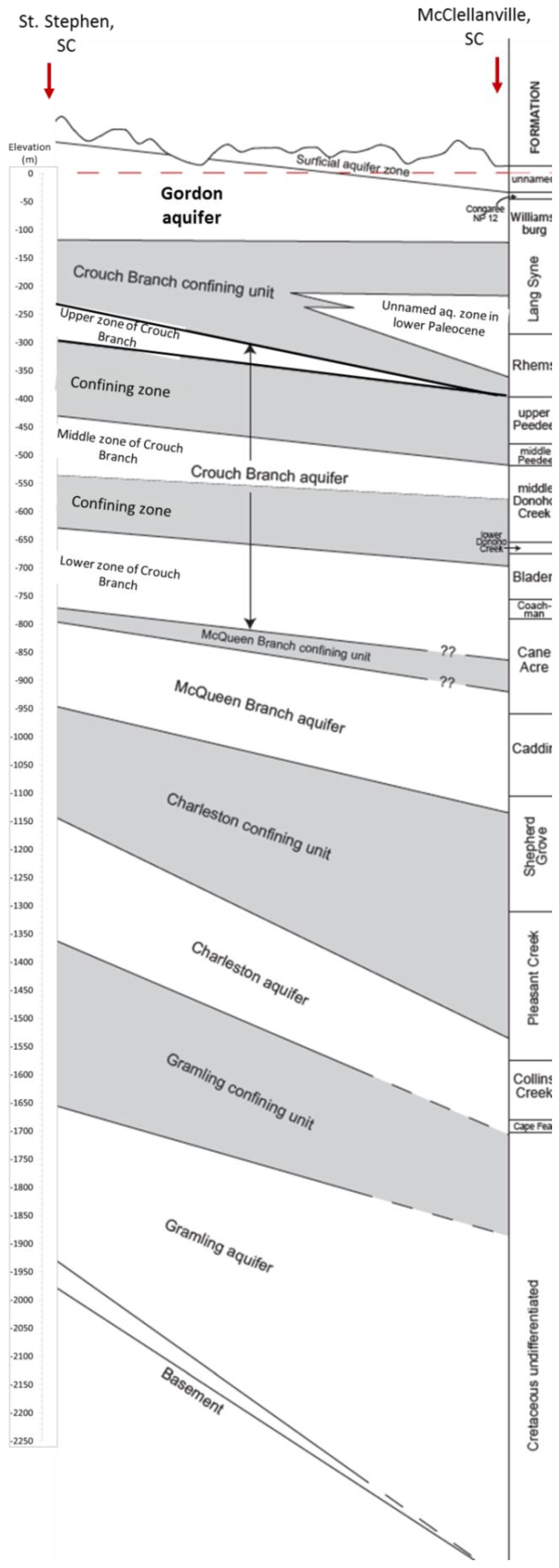
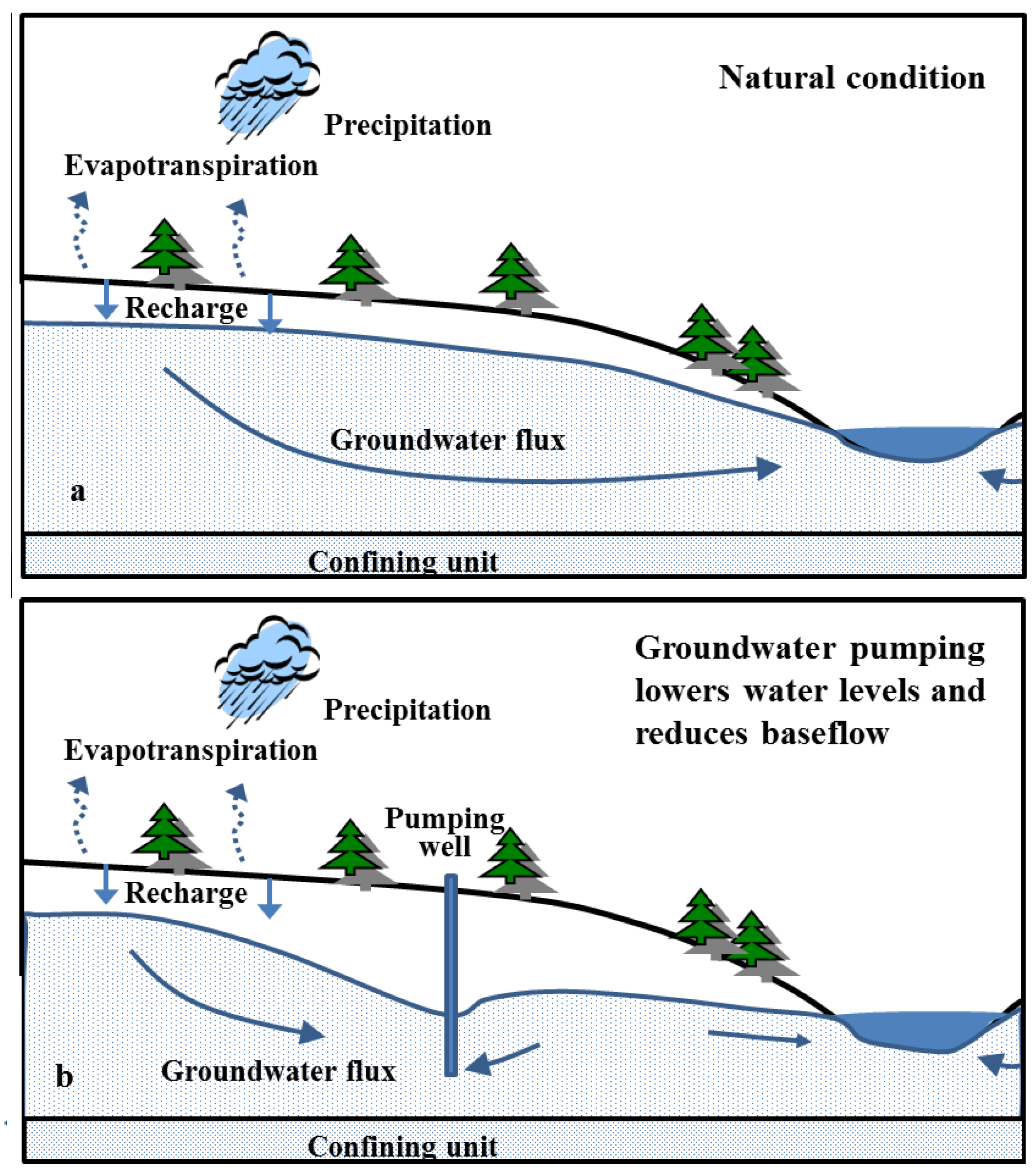
3.1. Groundwater Extraction

Groundwater in coastal areas such as the southeastern U.S. is a critical resource and its importance rises as the coastal population increases [5,53]. Arguments may be made that the footprint of even a large wellfield in forested locations can be small and minimally obtrusive (small fenced enclosures at the actual sites of the scattered wells), and with pipelines, and even electrical powerlines, that can be unobtrusively buried along existing roads. Where there will be much more risk to the forest environment will be in the hydrological effects, and the correct prediction and understanding of the impacts can be complicated by misunderstandings and inaccurate assumptions in assessments of proposed pumping. Assessments are often designed to determine the available water yield from an aquifer and its drawdown impact to that aquifer. The effects on adjacent (vertically separated) aquifers, surface waters, and natural environments (e.g., vegetation) are far less common or developed, but are critically necessary [54,55,56]. It is possible that the deepest major aquifers beneath the coastal plain are sufficiently hydraulically isolated from the surficial aquifer, so that they might be pumped safely and even heavily, without harm to near-surface environments. However, it is the shallower systems (e.g., the Tertiary-aged Gordon [limestone and sand] aquifer in coastal South Carolina USA) that are used as reservoirs for aquifer storage and recovery, and for construction materials through sand mining operations. The Gordon aquifer has also been affected by saltwater intrusion and is no longer widely used as a major water supply resource [57].
The FMNF is almost exclusively dominated by forests and wetlands on high water table soils [8,58], and thus, these ecosystems are vulnerable to the minor lowering of the water table. A specific problem seen in this area, and in similar settings worldwide, is fire susceptibility; an increased depth of the water table beneath peat-rich wetlands can increase the fire risk. A forest on shallow water table soils in west-central Florida, USA, is an analog to the FMNF situation. Pronounced ecological effects accompanied water table lowering caused by the large-scale pumping of the underlying Floridan (limestone) aquifer northeast of the Tampa Bay, Florida, USA, metropolitan area [56]; the Floridan aquifer is closely related to the Gordon aquifer beneath the FMNF. Reduced groundwater discharge to springs and streams as a baseflow is also to be expected from groundwater pumping of a shallower aquifer, due to a decline in the water table (see Figure 5). Groundwater extraction proposals will have to be examined carefully from an ecological, as well as hydraulic and land-use, perspective.
There is concern surrounding the misinterpretation of the vulnerability of the surface ecosystem and hydrological system to heavy and prolonged groundwater pumping. Figure A1 shows a hydrogeological cross-section model of the coastal plain subsurface for South Carolina [31]. A geological formation beneath the uppermost principal aquifer may have a different lithology (in this case, sand versus limestone) and different geological formation names (e.g., the Gordon aquifer, within the Black Mingo Formation, also known locally as the Santee Limestone). In different parts of the region, multiple strata may operate in concert as a single water-bearing unit, or stratigraphic separation may result in hydraulic isolation. Proponents of new pumping may refer to geological information and argue that the groundwater systems are separated, when in fact, the systems are hydraulically connected. This has been shown for the Gordon aquifer, where limestone is underlain by sands in other nearby areas of this combined system, located inland from the coast [30,31]. In the absence of data, it is a mistake to assume that pumping from a deeper stratum does not involve the extraction of water from shallower units and to conclude that the surface wetland or shallow-water table environment will not be affected.
A technical evaluation of the interconnection of the water table aquifer with deeper aquifers from which heavy pumping is proposed is difficult and prone to misinterpretation, even with existing hydraulic data [55,59,60]. Estimating the permeability of confining units between aquifers presents sampling challenges for obtaining a representative volume of material, and important heterogeneities can go undetected. Furthermore, pumping-test data can be misinterpreted. Even where long-term pumping of an aquifer would presumably lower the water table and affect groundwater-dependent forest ecosystems, the interconnection of a deeper aquifer with the shallow water table aquifer can be missed, despite the use of pumping tests purported to be designed to disprove such an interconnection. The absence of drawdown in a shallower aquifer should not suggest a lack of effective interconnection. Longer-term effects could prove problematic under future widespread, prolonged heavy pumping of the deeper aquifer. In the absence of withdrawal by groundwater pumping, one can detect the forest demand for water through ET processes (Figure 8). Ecosystem demands for water use in the form of forest ET can be substantial (7 mm·d−1 for a forested site in coastal North Carolina, USA [61]). Figure 8 data were interpreted using a water table fluctuation method [62], providing an estimated 0.8 mm·d−1 or rather 8 m3·d−1 per hectare ET demand from the water table aquifer (this water table fluctuation method accounts for the specific yield of the sediment). There are many caveats, such as spatial variability, that should be considered when upscaling such an estimate, but as a means of comparison, let us assume a groundwater pumping schedule of 20 m3·d−1, a transmissivity and storativity of the aquifer of 100 m2·d−1 and 1.5, respectively, and consider the potential drawdown 50 m distant after 100 days of pumping. Applying the Theis solution, this theoretical location could see up to 3 cm of drawdown (using the Theis relationship for confined aquifers, which overestimates drawdown in unconfined systems [63]). Nonetheless, this pumping could affect the water table position and upset the dynamic equilibrium of the forest hydrology. We emphasize the need for field data to properly quantify the potential effects of long-term pumping on forest conditions.
Furthermore, a change in the species composition alters the vulnerability to drought and the relative magnitude of water balance components through changes in ET, both in terms of interception and transpiration [32,33,64]. For example, transpiration rates for a given diameter yellow poplar (Liriodendron tulipifera; diffuse porous xylem) were nearly twofold greater than for hickory (Carya spp.; semi-ring porous) and fourfold greater than for oaks (Quercus spp.; ring porous xylem) [65]. The combination of shallow groundwater and high available energy in the Atlantic coastal plain region results in high ET rates [61]. At the FMNF, we have detected day-night signals in piezometers in the surficial aquifer and even within the upper portion of the Santee Limestone (Figure 8). Similarly, the ETg rate at a forested site in a floodplain system of the Congaree National Park in the upper (inner) coastal plain of South Carolina, USA, ranged from 0.2 to 4 mm·d−1 [66].
Wellfield conditions (wide, pronounced, prolonged pumping) are what eventually exhibit the effective interconnections where they exist. Therefore, an assessment in the short-term and prior to the commitment to a wellfield, is not easy [60]. One may not see any appreciable effects until after a few years of heavy pumping and wellfields, which, once established, are effectively permanent infrastructure. Expert technical advice focused upon the surface and shallow subsurface environments will be needed to evaluate the acceptability of any proposed heavy prolonged pumping in natural areas [55,56]. Short-term heavy pumping for temporary dewatering, to extract construction materials, may be sustainable, and for such a case, the quality of the pumped water could be a concern, especially if the water has a large silt content.
An additional cause for concern is pumping-induced subsidence due to aquifer compression. One counter-intuitive result of large-scale pumping of a deep aquifer could be that the surface wetness may increase due to physical compression and lower land elevation. Thick sand aquifers with an appreciable clay content as interlayers may be susceptible to this problem if heavily pumped, and large cones of depression may form to produce a large (broad and deep) drawdown. Careful attention should be paid to studies of these same aquifers undergoing large-scale pumping. Any major wellfield planning or development of hydraulically low-risk deep aquifers should include the rigorous assessment of this wide-acting land subsidence factor.

3.2. Geologic Materials Extraction

We note that large-scale withdrawals may include not only wellfields for water supply, but also variable-duration pumping (dewatering) for construction and industrial material extraction (e.g., sand, shell, or limestone mining). Such efforts have occurred in other areas of the coastal plain and have targeted the shallow, unconfined aquifer, also known as the surficial aquifer [67].
This is an important threat to shallow groundwater systems because sand mining is increasing in frequency in rural areas near metropolitan areas, due to the value of sand as fill material for site construction development. Lands targeted for sand mining in the coastal plain of South Carolina are on ancient beach ridges that trend in a NE-SW orientation, parallel to the modern coastline [68]. Unlike direct impacts on surface water hydraulics from excavation activities that target instream locations of rivers (e.g., Ganges-Brahmaputra-Meghna basin of south Asia) or beach systems (e.g., western Australia), inland sand mining often involves dewatering activities to lower the water table, so that heavy machinery can operate. To our knowledge, indirect impacts on water table conditions from such activities are not well-documented in the literature, although sinkhole formation has been triggered near mines to the northwest, near Harleyville, SC, USA [69].
The water resource demand from growing urban areas may include proposals for heavy pumping (water withdrawals), but also wastewater disposal, as seen in other areas of the southeastern U.S. coastal plain. Changes resulting from groundwater pumping were significant as of 1982, based on a quasi-three-dimensional, finite-difference digital ground-water flow model that the author constructed to simulate flow in the coastal plain aquifers, prior to development [70]. It was noted that head declines in the deep McQueen Branch and Charleston aquifers (formerly known as Black Creek and Middendorf, respectively) have occurred throughout much of the eastern part of the Coastal Plain of South Carolina, as a result of pumping in the Myrtle Beach and Florence areas. This is an area for which needs to be researched considering the large increases in population and resource demand since the 1980s. With regard to the discharge of treated municipal wastewater, this practice is not without value in places, but the potential hydrologic/hydraulic, nutrient, geochemical, and ecological effects on receiving waters, may not be tolerable in systems managed for their natural conditions [71]. Similarly, the disposal of wastewater to land, streams, or wetlands as a byproduct of drinking water treatment (e.g., reverse osmosis waste flow from treating mineralized, high dissolved solids groundwater), also has hydraulic, geochemical and ecological effects. Ultimate ecological effects must be carefully considered for systems receiving such discharges.
The pressure for the extraction of subsurface materials, in addition to sand and other building materials, in the coastal plain of the U.S. is likely to increase due to continued urban and industrial growth, especially if private entities hold the mineral rights. Additionally, any low-elevation urban or urbanizing coast is going to have enormous eventual demands for fill or raised-pad material under the conditions of a rising sea level. Geological resources definitely include abundant limestone, sands, and some deposits of histosols, soils with more than half of the upper 80 cm of the profile with organic matter, including muck (sapric soil) and peat (fibric soil) [72], and perhaps some geologically young marine shell deposits [73]. We postulate that sand, limestone, shell, and organic-rich soils will be common earth materials targeted for extraction across the southeastern coastal plain of the U.S. With respect to the extraction of muck and peat from wetland systems, if marketed as a renewable resource, management staff should be aware that such deposits required a few millennia to accrete, whereas true renewable materials can be restored on time scales of a growing season, up to a few decades.

3.3. Paleoenvironmental Information Loss

The natural (though probably aboriginal-mediated) pre-European fire regime will be important to understand, as will the early vegetation community structure and water chemistry, and perhaps most importantly, any long-term changes or successions, as well as the types and frequencies of disturbances [44]. The organic-matter-rich wetland and aquatic sediments in certain depressions in the coastal plain of the U.S. are very amenable to recording evidence of such conditions, but they are not only susceptible to mining or incidental excavation (e.g., pond building), but are also susceptible to outright burning and total destruction in severe or drainage-aggravated drought. More subtly, and more easily unseen, partial drainage can subject them to aerobic microbial degradation and loss (an aspect of peat subsidence). Preventing drainage or digging of organic sediments is critically important. For example, a hydrology simulation model was developed to show the impacts of minor drainage for silviculture on wetland hydrology, particularly the lateral impacts on water tables draining ten major soil types in the Atlantic coastal plain, including a site within the FMNF [74]. It has been shown that drainage ditches (canals) of 0.9 m deep had a significant effect on lateral flows in coastal plain catchments, due to water table lowering [74]. Furthermore, peat-surface lowering by a fire event or slower subsidence can have strong direct ecological effects, persisting in a wetland for millennia [75,76]. Not only can the unique original peatland environment, whether large or tiny, be highly altered or destroyed, but an irreplaceable record of past environmental conditions will be lost with it: the pollen, spores, and rootlets that tell of vegetation succession, and perturbation, and by inference, about climate; the diatom frustrules and sponge spicules that tell of past water chemistry; the charcoal fragments that record past fire regimes and any changes; the chemicals that reveal natural-era concentrations and deposition (e.g., mercury); and the gross sediment stratigraphy itself, with its implied environmental record. Pollen analysis provides information on the age of deposition and the climatic condition [77,78]. Relatedly, soil and sediment samples from about 2–3 m below the ground surface in the thick (~6 m) hidden organic sediments of a cypress pond wetland system, yielded a carbon-14 isotope (14C) date of ~11,000 years BP (before present), from which a post-glacial paleoecological record might be inferred for this region. This could record the original establishment of pine forest, probably between 5000 and 7000 BP. Organic-rich muck and organic-rich sediments occur in the FMNF [72,79], and in a sinkhole depression in the Holly Hill, SC, area, reaching at least ~1.5 m depth. These similarly suggest great potential for microfossil paleoenvironmental evidence. Let us not lose these valuable environmental records.

4. Future Research Considerations

Beyond the changeable controls on the surface and near-surface hydrology, there needs to be a good understanding of hydrological effects upon ecology, mainly on plant ecology at both the species and vegetation community scale, across the landscape. Investigating the linkages and controls exerted by physical (and also possibly chemical) hydrology, and its shifts, upon the biota and ecology is critical and essential, but may be more difficult than just gaining a good hydrological understanding. The following types of swamp systems have been identified by the USDA Forest Service [19] as those that exhibit dependency on groundwater in the Atlantic coastal plain physiographic province: stream head seepage swamp, pocosin, baygall, nonriverine basin swamp, and wet hardwood forest sandhill seep. Most of the wetland types in the southeastern U.S. coastal plain are found in landscape depressions and may be classified as geographically-isolated wetlands (GIWs). The collection of similar depression wetlands in the U.S., approximately along the longitude of 100° W, has many similarities [80]. Individually, these features are relatively small in area (less than 20 hectares). Research efforts there have included geospatial analyses such as light detection and ranging (LiDAR) data interpretations, in order to model the hydrological functions [81]. Such an approach could be taken at many locations worldwide, where such remotely-sensed data are available. Examples of potential mechanistic modeling tools were reviewed [82], which could be applied to advance scientific understanding concerning the extent to which hydrological connections between GIWs and other surface waters exist, and how these connections affect the downstream hydrology at the scale of watersheds. For example, some of the concerns with regulating protections for GIWs in the U.S. typically stem from the confusion on whether a significant nexus with navigable waters exists, and thus, whether such wetland systems should receive jurisdictional oversight by governing bodies [83]. In the U.S., navigable waters are regulated by the U.S. Army Corps of Engineers [84]. However, the significant nexus debate about wetlands has been limited to the surface and shallow subsurface environments; other than carbonate aquifers with relatively short residence times, such as the Edwards aquifer in Texas and the Floridan and Biscayne aquifers in Florida, USA, there is a dearth of information about the link between groundwater extraction and wetland dynamics in the coastal plain of the southeastern U.S.
Furthermore, an additional need is for the hydrologic monitoring of the water balance in changing forest conditions. Specifically, the restoration of forest communities to longleaf pine—savanna conditions in the southeastern U.S. has been a region-wide initiative for the last 10–15 years, with efforts ongoing [85,86]. A large majority of southeastern U.S. forests are loblolly pine-dominated stands [86]; loblolly pine is an important wood product, and additionally, fire suppression management protocols over the previous several decades have allowed the naturally fire-tolerant longleaf pine to be outcompeted in many forest systems. It is hypothesized that the restoration of longleaf pine on large scales may change the water balance, due to its potentially smaller ET flux compared to loblolly pine stands [87]. It follows that a larger fraction of the water balance would be available as surface and shallow-subsurface runoff to receiving waters (streams and riparian or depression wetlands), as well as infiltration and recharge to deeper groundwater systems. Data on ET fluxes from loblolly pine forests are well known [61,88], but information on longleaf pine is lacking. The effects on the forest condition in coastal areas from extreme events may be analogous, such as the immediate and also longer-term ecosystem changes following cyclones. In the southeastern U.S., major hurricanes over the past several decades have destroyed large tracts of forests and researchers have analyzed how the succession of forest communities has been affected by these events. Structural damage from intense winds and flooding are the short-term impacts, but the subsequent reduction of the forest canopy and the salinization of soils in the storm surge areas can produce longer-term effects on the water budget, specifically by increasing outflows from coastal watersheds; Hurricane Hugo made landfall in September 1989, and in some respects, the forest ecological processes and streamflow behavior have not yet returned to the pre-storm conditions [45,89]. Coastal forests have evolved resiliencies over millennia and have adapted to short-term impacts, yet widespread demand for forested water resources is cause for increased investigations on the role of groundwater in modulating stresses on forest resources. A slower-moving threat in the coastal zone is the rise and inundation of the sea level, in areas not previously affected by higher-salinity waters and/or longer-duration hydroperiods. Information exists on the value of coastal ecosystems that provide resiliency to communities (ecological and human) [90] and sea level stressors on the coastal forest community structure [91], for example. However, further research is needed to understand how a rising elevation of receiving waters, such as the sea level, and its indirect connections to coastal streams and rivers, may affect the hydraulics of coastal runoff and groundwater dynamics due to a reduced hydraulic gradient.

5. Summary

The management of forest resources benefits from analyzing systems, using a multidisciplinary approach to understand how changes in the physical environment may affect forest conditions in a future of increasing demand and multiple stressors. We specifically presented information on the role of groundwater as a driver in coastal forests that have adapted to a naturally shallow water table position and wet-dry cycles. With increased pressures from population growth and the expansion of metropolitan areas, forest managers working in these landscapes are faced with complex issues. The forested lands of the southeastern U.S. coastal plain have supported the regional and national economy for many decades, but forest-stressing activities (e.g., sand extraction for building materials to the construction sector and land clearing for housing development) have intensified the need to understand how the local and regional water cycle supports the forest systems. In this region, with a relatively warm and humid climate, precipitation and evapotranspiration are the dominant fluxes of the water cycle, and lengthened dry periods and groundwater pumping can result in water imbalance and stress in forest systems. Similar coastal settings worldwide are affected by similar climate- and human-induced stressors. Shallow water tables support a wide diversity of wetland and stream systems, yet seemingly small changes in the water budget can either greatly increase runoff in response to extreme storm events, or reduce flows to these receiving waters as a result of decreased groundwater flux. The management of forests must include an understanding of the regional water cycle, including the role of groundwater in sustaining forest functions, as the need for these lands and resources therein increase. Sustainably maintaining forest values thus requires leadership on identifying and enacting research and management opportunities across multiple disciplines.

Acknowledgments

Thanks to Francis Marion National Forest silviculturist Alton Gaskins and Santee Experimental Forest biological technician Julie Arnold for providing the maps.

Author Contributions

P.S. conceived the project idea, produced the initial draft manuscript, and contributed a significant number of literature sources; T.C. and D.A. added to the literature and, included field data and relevant maps in context of the manuscript theme; T.C. led the writing of subsequent drafts; D.A. conducted thorough edits of the subsequent drafts.

Conflicts of Interest

The authors declare no conflict of interest.

Appendix

Figure A1. Idealized cross-section of outer coastal plain, central South Carolina, USA [31].
Sustainability 09 00447 g009

References

  1. Wilson, E.O. Half Earth: Our Planet’s Fight for Life; W.W. Norton and Co.: New York, NY, USA, 2016; ISBN 978-1631490828. 272p. [Google Scholar]
  2. Nix, S. Maps of the World’s Forests: World Forest Cover Type Maps and Natural Tree Ranges. About Education. 2016. Available online: http://forestry.about.com/od/forestresources/tp/world_Forest_Cover.htm (accessed on 22 November 2016).
  3. Williams, T.M.; Amatya, D.M.; Bren, L.; deJong, C.; Nettles, J.E. Future directions in forest hydrology. In Forest Hydrology: Processes, Management, and Applications; Amatya, D., Williams, T., Bren, L., de Jong, C., Eds.; CABI Publishers: Wallingford, UK, 2016; pp. 270–279. [Google Scholar]
  4. Harris, N. Global Forest Watch Climate: Summary of Methods and Data; World Resources Institute: Washington, DC, USA, 2016; Available online: http://www.wri.org/publication/gfw-climate-methods-data (accessed on 20 November 2016).
  5. Caldwell, P.; Muldoon, C.; Miniat, C.F.; Cohen, E.; Krieger, S.; Sun, G.; McNulty, S.; Bolstad, P.V. Quantifying the Role of National Forest System Lands in Providing Surface Drinking Water Supply for the Southern United States. Available online: https://www.srs.fs.usda.gov/pubs/47706 (accessed on 27 February 2017).
  6. National Oceanic and Atmospheric Administration. National Coastal Population Report: Population Trends from 1970 to 2020. Available online: http://stateofthecoast.noaa.gov (accessed on 18 November 2016).
  7. Town of Mount Pleasant. 2016 Demographics Report. Town of Mount Pleasant Department of Planning and Development. Available online: http://www.tompsc.com/DocumentCenter/View/17486 (accessed on 18 November 2016).
  8. United States Department of Agriculture (USDA) Forest Service. Francis Marion National Forest Plan Revision Environmental Impact Statement; USDA Forest Service, Sumter and Francis Marion National Forests: Columbia, SC, USA, 2015.
  9. USDA Forest Service. Francis Marion National Forest: Draft Forest Plan Assessment, 2.2: Air, Soil, and Water Resources and Quality; USDA Forest Service: Columbia, SC, USA, 2013.
  10. USDA—Natural Resources Conservation Service (NRCS). Soil Taxonomy: A Basic System of Soil Classification for Making and Interpreting Soil Surveys; U.S. Government Printing Office: Washington, DC, USA, 1999; 869p.
  11. Dahl, T. Wetland Losses in the United States: 1780s to 1980s; U.S. Department of the Interior, Fish and Wildlife Service: Washington, DC, USA, 1990; 13p.
  12. McCauley, L.; Jenkins, D.; Quintana-Ascencio, P. Isolated wetland loss and degradation over two decades in an increasingly urbanized landscape. Wetlands 2013, 33, 117–127. [Google Scholar] [CrossRef]
  13. Reice, S. Nature in Fragments: the Legacy of Sprawl; Johnson, E.A., Klemens, M.W., Eds.; Columbia University Press: New York, NY, USA, 2005; 400p. [Google Scholar]
  14. Mitsch, W.; Gosselink, J. Wetlands, 3rd Ed. ed; Wiley, Inc.: New York, NY, USA, 2000. [Google Scholar]
  15. Wilkinson, C.; Sudara, S.; Chou, L. Mangrove forests. In Proceedings of the Third ASEAN-Australia Symposium on Living Coastal Resources, Bangkok, Thailand, 16–20 May 1994; Australian Institute of Marine Science: Townsville, Queensland, Australia, 1994. [Google Scholar]
  16. Krieger, D.J. The Economic Value of Forest Ecosystem Services: A Review; The Wilderness Society: Washington, DC, USA, 2001; 40p. [Google Scholar]
  17. Hester, A. Establishing the Francis Marion: National forest history in South Carolina’s Lowcountry, 1901–1936. Available online: http://www.foresthistory.org/Publications/FHT/FHTSpringFall2011/Francis_Marion.pdf (accessed on 27 February 2017).
  18. USDA Forest Service. Groundwater-Dependent Ecosystems Level I: Inventory Field Guide—Inventory Methods for Assessment and Planning; USDA Forest Service: Washington, DC, USA, 2012; 191p.
  19. USDA Forest Service. Groundwater-Dependent Ecosystems: Level II Inventory Field Guide—Inventory Methods for Project Design and Analysis; USDA Forest Service: Washington, DC, USA, 2012; 124p.
  20. Howard, J.; Merrifield, M. Mapping Groundwater Dependent Ecosystems in California. PLoS ONE 2010, 5, e11249. [Google Scholar] [CrossRef] [PubMed]
  21. Laio, F.; Tamea, S.; Ridolfi, L.; D’Odorico, P.; Rodriguez-Iturbe, I. Ecohydrology of groundwater-dependent ecosystems: 1. stochastic water table dynamics. Water Resour. Res. 2009, 45, W05419. [Google Scholar] [CrossRef]
  22. Tamea, S.; Laio, F.; Ridolfi, L.; D’Odorico, P.; Rodriguez-Iturbe, I. Ecohydrology of groundwater-dependent ecosystems: 2. stochastic soil moisture dynamics. Water Resour. Res. 2009, 45, W05420. [Google Scholar] [CrossRef]
  23. Williams, T.; Krauss, K.; Okruszko, T. Hydrology of flooded and wetland forests. In Forest Hydrology: Processes, Management, and Applications; Amatya, D., Williams, T., Bren, L., de Jong, C., Eds.; CABI Publishers: Wallingford, UK, 2016; pp. 103–123. [Google Scholar]
  24. Luo, W. Quantifying groundwater-sapping landforms with a hypsometric technique. J. Geophys. Res.-Planets 2000, 105, 1685–1694. [Google Scholar] [CrossRef]
  25. Callahan, T.J.; Vulava, V.M.; Passarello, M.C.; Garrett, C.G. Estimating groundwater recharge in lowland watersheds. Hydrol. Proc. 2012, 26, 2845–2855. [Google Scholar] [CrossRef]
  26. Amatya, D.; Callahan, T.; Hansen, W.; Trettin, C.; Radecki-Pawlik, A.; Meire, P. Turkey Creek—A case study of ecohydrology and integrated watershed management in the low-gradient Atlantic Coastal Plain, USA. J. Water Resour. Prot. 2015, 7, 792–814. [Google Scholar] [CrossRef]
  27. Pleva, T.; Hansen, W. Current Status of Water Quality Information on the Francis Marion National Forest; USDA Forest Service Francis Marion and Sumter National Forests: Columbia, SC, USA, 2003; 43p.
  28. Amatya, D.M.; Callahan, T.J.; Trettin, C.C. Synthesis of 10 years of studies on Turkey Creek Watershed. In Headwaters to Estuaries: Advances in Watershed Science and Management; Stringer, C.E., Krauss, K.W., Latimer, J.S., Eds.; USDA-Forest Service: Asheville, NC, USA, 2016. [Google Scholar]
  29. Dai, Z.; Trettin, C.C.; Amatya, D.M. Effects of Climate Variability on Forest Hydrology and Carbon Sequestration on the Santee Experimental Forest in Coastal South Carolina; U.S. Department of Agriculture Forest Service Southern Research Station: Asheville, SC, USA, 2013; 44p.
  30. Edwards, L.E.; Gohn, G.S.; Self-Trail, J.M.; Prowell, D.C.; Bybell, L.M.; Bardot, L.P.; Firth, J.V.; Huber, B.T.; Frederiksen, N.O.; MacLeod, K.G. Physical Stratigraphy, Paleontology, and Magnetostratigraphy of the USGS—Santee Coastal Reserve Core (CHN-803), Charleston County, South Carolina; U.S. Department of the Interior: Washington, DC, USA, 1999; 66p.
  31. Campbell, B.; Coes, A. Groundwater Availability in the Atlantic Coastal Plain of North and South Carolina; U.S. Department of the Interior: Washington, DC, USA, 2010; 242p.
  32. Dean, J.; Camporese, M.; Webb, J.; Grover, S.; Dresel, P.; Daly, E. Water balance complexities in ephemeral catchments with different land uses: Insights from monitoring and distributed hydrologic modeling. Water Resour. Res. 2016, 52, 4713–4729. [Google Scholar] [CrossRef]
  33. Dean, J.; Webb, J.; Jacobsen, G.; Chisari, R.; Dresel, P. A groundwater recharge perspective on locating tree plantations within low-rainfall catchments to limit water resource losses. Hydrol. Earth Syst. Sci. 2015, 19, 1107–1123. [Google Scholar] [CrossRef]
  34. Skaggs, R.W. A Water Management Model for Shallow Water Table Soils; Report No. 134; University of North Carolina, Water Resources Research Institute: Raleigh, NC, USA, 1978. [Google Scholar]
  35. Pyzoha, J.E.; Callahan, T.J.; Sun, G.; Trettin, C.C.; Miwa, M. A conceptual hydrologic model for a forested Carolina bay depressional wetland on the coastal plain of South Carolina, USA. Hydrol. Process. 2007, 22, 2689–2698. [Google Scholar] [CrossRef]
  36. Weems, R.E.; Lewis, W.C. Detailed Geologic Sections from Auger Holes in Northeastern Charleston County, South Carolina, East of 79 Degrees, 45 Minutes West Longitude; U.S. Department of the Interior: Washington, DC, USA, 1997; 84p.
  37. Weems, R.E.; Bybell, L.M. Geology of the Black Mingo Group (Paleocene) in the Kingstree and St. Stephen areas of South Carolina. Trans. Am. Philos. Soc. 1999, 88, 9–27. [Google Scholar] [CrossRef]
  38. Wachob, A.; Hockensmith, B.; Luciano, K.; Howard, C.S. Potentiometric Surface of the Floridan and Tertiary Sand Aquifers in South Carolina, November 2013; South Carolina Department of Natural Resources, Land, Water and Conservation Division: Columbia, SC, USA, 2014.
  39. Harder, S.V.; Amatya, D.M.; Callahan, T.J.; Trettin, C.C.; Hakkila, J. Hydrology and water budget for a forested Atlantic coastal plain watershed, South Carolina. J. Am. Water Resour. Assoc. 2007, 43, 563–575. [Google Scholar] [CrossRef]
  40. Henderson, J.; Grissino-Mayer, H. Climate–tree growth relationships of longleaf pine (Pinus palustris Mill.) in the southeastern coastal plain, USA. Dendrochronologia 2009, 27, 31–43. [Google Scholar] [CrossRef]
  41. Williams, T. Response of shallow water tables to rainfall. In Proceedings Soil Moisture and Site Productivity Symposium; Balmer, W., Ed.; U.S. Department of Agriculture Forest Service: Myrtle Beach, SC, USA, 1978; pp. 363–370. [Google Scholar]
  42. Amatya, D.M.; Sun, G.; Skaggs, R.W.; Trettin, C.C. Testing of DRAINMOD for forested watersheds with non-pattern drainage. In Proceedings of the ASAE Annual International Meeting, Las Vegas, NV, USA, 27–30 July 2003; Paper Number: 032046.
  43. Galloway, D.L.; Alley, W.M.; Barlow, P.M.; Reilly, T.E.; Tucci, P. Evolving Issues and Practices in Managing Ground-Water Resources: Case Studies on the Role of Science; U.S. Department of the Interior: Washington, DC, USA, 2003; 73p.
  44. Dean, J.; Webb, J.; Jacobsen, G.; Chisari, R.; Dresel, P. Biomass uptake and fire as controls on groundwater solute evolution on a southeast Australian granite: Aboriginal land management hypothesis. Biogeosciences 2014, 11, 4099–4114. [Google Scholar] [CrossRef]
  45. Williams, T.; Song, B.; Trettin, C.; Gresham, C. A Review of spatial aspects of forest damage and recovery on the South Carolina coast following Hurricane Hugo. J. Geogr. Nat. Disasters 2013, 3, 110. [Google Scholar]
  46. Marion, D.A.; Sun, G.; Caldwell, P.V.; Ford, C.R.; Ouyang, Y.; Amatya, D.M.; Clinton, B.D.; Conrads, P.A.; Gull-Laird, S.; Dai, Z.; et al. Managing forest water quantity and quality under climate change. In Climate Change Adaptation and Mitigation Management Options: A Guide for Natural Resource Managers in Southern Forest Ecosystems; Vose, J., Kleipzig, K., Eds.; CRC Press: Boca Raton, FL, USA, 2013; 496p. [Google Scholar]
  47. Williams, T.M.; Amatya, D.M.; Jayakaran, A.; Song, B.; Trettin, C.; Krauss, K. Runoff generation from shallow southeastern forests: Unusual behavior of paired watersheds following a major disturbance. In Proceedings of the ASABE Annual International Meeting, Dallas, TX, USA, 29 July–1 August 2012; American Society of Agricultural and Biological Engineers: Dallas, TX, USA; Paper Number: 121337045.
  48. Epps, T.H.; Hitchcock, D.R.; Jayakaran, A.D.; Loflin, D.R.; Williams, T.M.; Amatya, D.M. Characterization of storm flow dynamics of headwater streams in the South Carolina lower coastal plain. J. Am. Water Res. Assoc. 2012, 49, 76–89. [Google Scholar] [CrossRef]
  49. Amatya, D.M.; Skaggs, R.W. Long-term hydrology and water quality of a drained pine plantation in North Carolina, USA. Trans. ASABE 2011, 54, 2087–2098. [Google Scholar] [CrossRef]
  50. Amatya, D.; Jha, M. Evaluating the SWAT model for a low-gradient forested watershed in coastal South Carolina. Trans. ASABE 2011, 54, 2151–2163. [Google Scholar] [CrossRef]
  51. Dai, Z.; Trettin, C.; Li, C.; Amatya, D.; Sun, G.; Li, H. Sensitivity of stream flow and water table depth to potential climatic variability in a coastal forested watershed. J. Am. Water Resour. Assoc. 2010, 46, 1036–1048. [Google Scholar] [CrossRef]
  52. Danish Hydraulic Institute (DHI). MIKE SHE Technical Reference; Danish Hydraulic Institute, DHI Water and Environment: Horsholm, Denmark, 2005. [Google Scholar]
  53. Williams, L.J.; Kuniansky, E.L. Revised Hydrogeologic Framework of the Floridan Aquifer System in Florida and Parts of Georgia, Alabama, and South Carolina; U.S. Department of the Interior: Washington, DC, USA, 2015; 156p.
  54. Llamas, M.R. Conflicts between wetland conservation and groundwater exploitation: Two case histories in Spain. Environ. Geol. Water Sci. 1988, 11, 241–251. [Google Scholar] [CrossRef]
  55. Stewart, M.; Langevina, C. Post audit of a numerical prediction of wellfield drawdown in a semiconfined aquifer system. Ground Water 1999, 37, 245–252. [Google Scholar] [CrossRef]
  56. Yobbi, D.K. Testing the Sensitivity of Pumpage to Increases in Surficial Aquifer System Heads in the Cypress Creek Well-Field Area, West-Central Florida—An Optimization Technique; U.S. Department of the Interior: Washington, DC, USA, 2002; 25p.
  57. Park, A.D. The Ground-Water Resources of Charleston, Berkeley, and Dorchester Counties, South Carolina. Water Resources Commission; Report Number 139; South Carolina Water Resources Commission: Columbia, SC, USA, 1985; 86p. [Google Scholar]
  58. USDA—Natural Resources Conservation Service. Soil Survey Report of Berkeley County, South Carolina; USDA—Natural Resources Conservation Service: Washington, DC, USA, 1980; 94p.
  59. Hoffman, J.L. The Noordbergum Effect; New Jersey Department of Environmental Protection, Division of Water Resources: Trenton, NJ, USA, 1984; 16p. [Google Scholar]
  60. Ostendorf, D.W.; DeGroot, D.J.; Judge, A.I.; LaMesa, D.F. Method to characterize aquitards above leaky aquifers with water supply wells. Hydrogeol. J. 2010, 18, 595–605. [Google Scholar] [CrossRef]
  61. Sun, G.; Noormets, A.; Gavazzi, M.; McNulty, S.; Chen, J.; Domec, J.-C.; King, J.; Amatya, D.; Skaggs, R.W. Energy and water balances of two contrasting loblolly pine plantations on the lower coastal plain of North Carolina, USA. For. Ecol. Manag. 2010, 259, 1299–1310. [Google Scholar] [CrossRef]
  62. Healy, R.; Cook, P. Using groundwater levels to estimate recharge. Hydrogeol. J. 2002, 10, 91–109. [Google Scholar] [CrossRef]
  63. Freeze, R.; Cherry, J. Groundwater; ISBN 978-0133653120: Prentice-Hall, Inc.: Upper Saddle River, NJ, USA, 1979; 604p. [Google Scholar]
  64. Zhang, L.; Dawes, W.R.; Walker, G.R. Response of mean annual evapotranspiration to vegetation changes at catchment scale. Water Resour. Res. 2001, 37, 701–708. [Google Scholar] [CrossRef]
  65. Vose, J.M.; Martin, K.L.; Barten, P.K. Applications to forest hydrological science to watershed management in the 21st century. In Forest Hydrology: Processes, Management, and Applications; Amatya, D., Williams, T., Bren, L., de Jong, C., Eds.; CABI Publishers: Wallingford, UK, 2016; pp. 240–253. [Google Scholar]
  66. Senn, L.H.-R. Ecohydrology of a Floodplain Forest: Relationships between Vegetation and Groundwater Response at Congaree National Park, South Carolina, USA. Master’s Thesis, University of Charleston, South Carolina, Charleston, SC, USA, 13 December 2014. [Google Scholar]
  67. Morton, R.A. An Overview of Coastal Land Loss: With Emphasis on the Southeastern United States; U.S. Department of the Interior: Washington, DC, USA, 2003.
  68. Colquhoun, D. Terrace sediment complexes in central South Carolina. University of South Carolina Press: Columbia, SC, USA, 1965; 62p. [Google Scholar]
  69. South Carolina Department of Natural Resources. Geologic Hazards of the South Carolina Coastal Plain 2012. Available online: http://www.dnr.sc.gov/geology/ggms5 (accessed on 2 February 2017).
  70. Aucott, W.R. Hydrology of the Southeastern Coastal Plain Aquifer System in South Carolina and Parts of Georgia and North Carolina (Regional Aquifers-System Analysis Southeastern Coastal Plain); U.S. Geological Survey Professional Paper 1410-E; U.S. Geological Survey: Washington, D.C. USA, 1986; 95p.
  71. Knight, R.L.; Clarke, R.A.; Keller, C.H.; Knight, S.L.; Petry, C. Great Swamp natural effluent management system—A summary of thirteen years of operations. Ecol. Eng. 2014, 73, 353–366. [Google Scholar] [CrossRef]
  72. USDA—Natural Resources Conservation Service. Histosols. In Soil Taxonomy: A Basic System of Soil Classification for Making and Interpreting Soil Surveys, 2nd ed.; Agriculture Handbook No. 436; Natural Resources Conservation Service: Washington, DC, USA, 1999; pp. 473–487, p. 886. [Google Scholar]
  73. Cameron, C.C.; Force, E.R.; Gazdik, G.C.; Rodehamel, E.C. Mineral Resources of the Wambaw Swamp Wilderness Study Area, Charleston County, South Carolina; U.S. Department of the Interior: Washington, DC, USA, 1979; 35p.
  74. Skaggs, R.W.; Phillips, B.D.; Chescheir, G.M.; Trettin, C.C. Effects of minor drainage on hydrology of forested wetlands. Trans. ASABE 2011, 54, 2139–2149. [Google Scholar] [CrossRef]
  75. Cypert, E. The effects of fires in the Okefenokee Swamp in 1954 and 1955. Am. Midl. Nat. 1961, 66, 485–503. [Google Scholar] [CrossRef]
  76. Stone, P.A. Some origins, successions, and questions regarding marsh inliers within S.E.U.S. forested peatlands. In Proceedings of the Southern Forested Wetlands Ecology and Management Conference, Clemson, SC, USA, 25–27 March 1996.
  77. Shelley, D.C. Geology, Geomorphology, and Tectonics of the Congaree River Valley, South Carolina. Ph.D. Thesis, University of South Carolina, Columbia, SC, USA, 18 May 2007. [Google Scholar]
  78. Shelley, D.C.; Werts, S.; Dvoracek, D.; Armstrong, W. Bluff to bluff: A field guide to floodplain geology and geomorphology of the Lower Congaree River Valley, South Carolina. In From the Blue Ridge to the Coastal Plain: Field Excursions in the Southeastern United States; Eppes, M., Bartholomew, M., Eds.; Geological Society of America Field Guides: Charlotte, NC, USA, 2012; Volume 29, pp. 67–92. [Google Scholar]
  79. DeSteven, D.; Harrison, C.A. Hydrology, Vegetation, and Landscape Distribution of Depression Wetlands on the Francis Marion National Forest—Final Report; USDA Forest Service Southern Research Station: Washington, DC, USA, 2006; 24p.
  80. Winter, T.; Rosenberry, D. Hydrology of prairie pothole wetlands during drought and deluge: A 17-year study of the Cottonwood Lake wetland complex in North Dakota in the perspective of longer term measured and proxy hydrological records. Clim. Chang. 1998, 40, 189–209. [Google Scholar] [CrossRef]
  81. Huang, S.; Young, C.; Abdul-Aziz, O.; Dahal, D.; Feng, M.; Liu, S. Simulating the water budget of a Prairie Potholes complex from LiDAR and hydrological models in North Dakota, USA. Hydrol. Sci. J. 2013, 58, 1434–1444. [Google Scholar] [CrossRef]
  82. Golden, H.E.; Lane, C.R.; Amatya, D.; Bandilla, K.; Raanan-Kiperwas, H.; Ssegane, H. Modeling watershed-scale hydrologic connections between geographically isolated wetlands and surface water systems. J. Environ. Model. Softw. 2014, 53, 190–206. [Google Scholar] [CrossRef]
  83. Rains, M.C.; Leibowitz, S.G.; Cohen, M.J.; Creed, I.F.; Golden, H.E.; Jawitz, J.W.; Kalla, P.; Lane, C.R.; Lang, M.W.; McLaughlin, D.L. Geographically isolated wetlands are part of the hydrological landscape. Hydrol. Process. 2015, 30, 153–160. [Google Scholar] [CrossRef]
  84. McKown, M.R. A wetland by any other name: Where does federal jurisdiction apply? GPSolo 2016, 33, 48–53. [Google Scholar]
  85. Gonzales-Benecke, C.A.; Martin, T.A.; Cropper, W.P., Jr. Whole-tree water relations of co-occurring mature Pinus palustris and Pinus elliottii var. elliottii. Can. J. For. Res. 2010, 41, 509–523. [Google Scholar] [CrossRef]
  86. Viner, B.; Parker, M.; Maze, G.; Varnedoe, P.; Leclerc, M.; Starr, G.; Aubrey, D.; Zhang, G.; Duarte, H. Intermediate time scale response of atmospheric CO2 following prescribed fire in a longleaf pine forest. J. Geophys. Res. Biogeosci. 2016, 121, 2745–2760. [Google Scholar] [CrossRef]
  87. Bacchus, S.T. Potential for reduced infiltration and recharge on a local scale following cover type conversions in the southeastern coastal plain. In Proceedings of the 1995 Georgia Water Resources Conference, The University of Georgia, Athens, GA, 11–12 April 1995; Hatcher, K.J., Ed.; Vinson Institute of Government: Athens, GA, USA, 1995. [Google Scholar]
  88. Whelan, A.; Starr, G.; Staudhammer, C.L.; Loescher, H.W.; Mitchell, R.J. Effects of drought and prescribed fire on energy exchange in longleaf pine ecosystems. Ecosphere 2015, 6, 128. [Google Scholar] [CrossRef]
  89. Jayakaran, A.; Williams, T.M.; Ssegane, H.S.; Amatya, D.M.; Song, B.; Trettin, C. Hurricane impacts on a pair of coastal forested watersheds: Implications of selective hurricane damage to forest structure and streamflow dynamics. Hydrol. Earth Syst. Sci. 2014, 18, 1151–1164. [Google Scholar] [CrossRef]
  90. Arkema, K.; Guannel, G.; Verutes, G.; Wood, S.; Guerry, A.; Ruckelshaus, M.; Kareiva, P.; Lacayo, M.; Silver, J. Coastal habitats shield people and property from sea-level rise and storms. Nat. Clim. Chang. 2013, 3, 913–918. [Google Scholar] [CrossRef]
  91. Saha, A.; Saha, S.; Sadle, J.; Jiang, J.; Ross, M.; Price, R.; Sternberg, L.; Wendelberger, K. Sea level rise and South Florida coastal forests. Clim. Chang. 2011, 107, 81–108. [Google Scholar] [CrossRef]
Figure 1. Illustration of the links between forest systems and human well-being.
Sustainability 09 00447 g001
Figure 2. Map of the Francis Marion National Forest, South Carolina, USA [8]. Locations of three piezometer nests in the surficial aquifer are also shown.
Sustainability 09 00447 g002
Figure 3. National Wetlands Inventory map, from the National Hydrography Dataset, U.S. Geological Survey, for a portion of the lower (outer) Atlantic coastal plain, USA. Outlined are the Francis Marion National Forest and the third-order watershed of Turkey Creek (US Geological Survey gage no. 02172035 at lat. 33.131, long. −79.783) [25,26].
Sustainability 09 00447 g003
Figure 4. Cyclical (seasonal or longer-term weather-induced) patterns of the water table position and potential impacts on a depression wetland system. Steps in the cycle include the summer or dry period (A); autumn or wetting-up period (B); winter or wet period (C); and spring or drying-down period (D). P refers to precipitation and ET is evapotranspiration [33].
Sustainability 09 00447 g004
Figure 5. Illustration of the water table and surface water interconnections under (a) natural conditions and (b) with groundwater extraction. A pumping well can intercept groundwater that would otherwise discharge to surface water bodies (adapted from [41]).
Sustainability 09 00447 g005
Figure 6. Stream water level and temperature data for a streambed water well at a headwater location of Turkey Creek (a third-order, 52 km2 area watershed in Berkeley County, SC, USA [26]). Water level data (as charted on the left-hand vertical axis) that was greater than zero reflects standing water in the stream channel; data less than zero represent subsurface water level in the streambed. In both cases, a datalogger containing a pressure transducer and temperature sensor was suspended in a stilling well installed in the streambed. Short-duration oscillations of the water level data reflect daytime water losses due to ET flux and the nighttime recovery of the water level.
Sustainability 09 00447 g006
Figure 7. Conceptual cross-section (a) showing one nested piezometer installation that is representative of three sites in the FMNF, lower Atlantic coastal plain of the U.S.; also shown are water level hydrographs: water table, surficial aquifer (Wando Formation [Fm]) [36], and upper portion of the Santee Limestone (Lms), upper Turkey Creek for five-week periods in (b) 2007 (below-normal precipitation) and (c) 2009, (above-normal precipitation) periods. Precip: precipitation; Piez: 9 m bgs: piezometric head at 9 m below ground surface; Piez: 15 m bgs: piezometric head at 15 m below ground surface. Ground elevation at all three sites is about 8.5 m above sea level.
Sustainability 09 00447 g007
Figure 8. Hourly water level data for the water table, surficial aquifer, and upper portion of the Santee Limestone, upper Turkey Creek. The sinusoidal pattern reflects evapotranspiration (ET) flux in this forest ecosystem. The groundwater ET (ETg) rate deduced from these water level data for this time period in June 2009 the average ETg was 0.8 mm·d−1. This was based on an assumed value for specific yield of the soils and sediments of 0.07 [25,39]. For comparison, an eddy covariance method estimated the ET to be about 7 mm·d−1 for a coastal forest in eastern North Carolina, USA [56].
Sustainability 09 00447 g008

