Detecting Human Presence and Influence on Neotropical Forests with Remote Sensing


1
University Research Priority Program in Global Change and Biodiversity and Department of Geography, University of Zürich, 8057 Zürich, Switzerland
2
Department of Geography, University College London, and NERC National Centre for Earth Observation (NCEO); UCL Dept. of Geography, Office 113, Pearson Building, Gower Street, London WC1E 6BT, UK [email protected]
3
Laboratoire Evolution et Diversité Biologique (EDB), UMR 5174, CNRS/UPS/IRD, Bâtiment 4R1 118, route de Narbonne, 31062 Toulouse, France
*
Author to whom correspondence should be addressed.
Remote Sens. 2018, 10(10), 1593; https://doi.org/10.3390/rs10101593
Submission received: 30 June 2018
/
Revised: 17 September 2018
/
Accepted: 27 September 2018
/
Published: 5 October 2018
(This article belongs to the Special Issue Remote Sensing of Tropical Forest Biodiversity)
Abstract
:The Amazon, and Neotropical forests, are one of the most important global biomes because of their extent and unique biodiversity, as well as their importance to global climate and as a habitat and resource for humans. Unravelling the influence of human presence on these forests is fundamental to our understanding of the biodiversity, ecosystem function, and service-providing potential. Human presence in these tropical rainforests dates back 13,000 years, and the impacts of this presence are hotly debated. Some authors suggest persistent effects of pre-Columbian plant domestication on current Amazonian forest composition. Other authors suggest that post-Columbian influence on forest composition is orders of magnitude higher than that of pre-Columbian times. Evidence from remote sensing has become increasingly useful as a way to help settle these debates. Here we review past, current, and future uses of remote sensing technology to detect human infrastructure in the Amazon and other Neotropical forests over the several historical periods of human presence, from archaeological to post-modern societies. We define human presence in terms of activities that left behind a footprint, such as settlements, earth-mounds, roads, use of timber and fuelwood, agriculture, soil, etc. Lastly, we discuss opportunities and challenges for the use of remote sensing to provide data and information necessary to expand our understanding of the history of human occupation in the Neotropical forests, and how this human occupation might affect biodiversity. There have been many recent applications of remote sensing to the detection of Pre-Columbian human infrastructure, from visual inspection of aerial photographs over deforested sites to uses of LiDAR on airborne and UAV platforms to detect infrastructure and smaller settlements under the canopy. Similar efforts are yet to be conducted for the Post-Columbian period, especially during the colonization and imperialism periods. Finally, our knowledge of human impacts in the modern era (20th and 21st centuries) is not-surprisingly more extensive. Remote sensing is still under-used and extremely useful for this type of application, and new missions might provide solutions that were unavailable before. Yet systematic ground surveys are irreplaceable, and detection accuracies of human presence from the combination of remote sensing and ground surveys need to be improved. It is vital therefore to understand how Neotropical forest biodiversity has developed in the presence of people in the past, the implications of this for predicting future directions of change in the Amazon and elsewhere.
1. Introduction
The Amazon is one of the most important global biome and a megadiverse hotspot of biodiversity, housing over 150,000 species over all taxonomic groups [1,2,3]. It plays a major role in the global carbon cycle [4,5], and in the water cycle [6,7,8], and it supports many livelihoods [9]. However, the Amazon currently faces high rates of deforestation [5,10,11], as well as high fragmentation [12] resulting in direct loss of biodiversity [13,14] and of ecosystem goods and services [15]. Human presence in the tropical rainforests of the Amazon dates back 13,000 years [16,17], and the impact of this long presence on ecosystems has motivated much ongoing debate [18,19,20,21,22,23,24,25,26]. The role of pre-Columbian societies in shaping these forests appears undisputable [19,24], even if was probably restricted to the most accessible regions and was short-term, over 10s to 100 years [23,25]. We define pre-Columbian as the time before the arrival and contact with Europeans in this region (approximately before 1500s). Evidence from floristic inventories suggests that some regions have been enriched in potentially domesticated plants, hinting at a shaping of the Amazonian flora by pre-Columbian societies [24], even if this finding has been disputed [23]. Indeed, floristic inventories tend to be biased towards accessible sites and many plants may have been casually used rather than domesticated. In any case post-Columbian influence on forest composition has been orders of magnitude higher than that of pre-Columbian times [24,25,26].
Unraveling human presence and its effects on Amazonia, and other Neotropical forests, is fundamental for several reasons. It advances our understanding of the dynamics of human presence in this large and still partly underexplored area, and its impacts on biodiversity and ecosystem services. Determining the historical impact of human presence is in turn critical to informing pathways of future change for biodiversity in the Amazon and elsewhere [27]. It should also serve to inform and guide valuations of natural capital and carbon sequestration potential of these ecosystems for programs such as REDD+ and other policy-led initiatives such as the recently approved report from the Intergovernmental Panel on Biodiversity and Ecosystem Services [9].
The rich history of land tenure and use in the Amazon, with occupation by multiple societies with complex structures, might have impacted large areas of Amazonian ecosystem beyond what we know today. In pre-Columbian times, Amazonia had widespread occupation by over 100 ethnical groups [28,29]. A wide array of evidence in favor of widespread pre-Columbian presence has been found in different parts of the Amazon, with raised fields found in the Guianas [30], shell mounds close to the Amazonas’ Delta and other archaeological sites along the Amazon basin [31], man-made soil types known as terra preta de indio [19], geoglyphs in the southeast of the Amazon basin [21], and earth-mounds further south in Bolivia [32,33]. These remains exemplify the diversity of activities in Amazonian societies, from forest foraging, shellfish foraging in the lower Amazon, plant domestication, and extensive slash-and-burn agriculture [31,32]. When European sailors arrived for the first time in the Americas in 1492, the native population was estimated to be between 8 to 20 million [34,35]. Colonization and its accompanying diseases led to a catastrophic decline in the pre-Columbian populations of the Americas [36]. The Amazon thus experienced a switch in land agency and management, with arguably significantly higher impacts than during pre-Columbian times [32,37]. During the colonization period, the areas occupied by the colonists overlapped considerably with those occupied by pre-historic populations [37], intensifying the use of the forest and increasing disease transmission from Europeans to local communities. After independence of Brazil in the mid-18th century followed by Simon Bolivar libertación in the early 19th century, the major part of the forest underwent a massive wave of land conversion. But it is not until the late 20th century that the rates of forest loss escalated [5,10,11], and we observe a boom-and-bust development at the deforestation frontier [38].
Reconstructing human presence and its influence in the Amazon is extremely challenging and there is a significant lack of knowledge on the peopling of the Amazon. The incompleteness of the historical record challenges our ability to fully understand the dynamics of human presence in the Amazon [37], and this problem becomes more acute in more distant time periods. Indeed, due to the Amazon’s characteristic acidic soils [39] and to frequent natural disturbances such as fires and floods, human artefacts are difficult to find. According to Fausto [40], all but stonework and pottery turns to dust and the dense forest hides the majority of the pre-historical sites. Large areas of the continent remain unknown from an archaeological and historical standpoint [40]. Over 126 ethnic groups exist today (according to [28,29]), and they have informed about the past history orally. However, this is only a small fraction of the full range of human diversity that once lived in the region, since about 95% of the ethnic groups are estimated to have disappeared [28,29,37] and the record is presumably very patchy and selective. Mayle and Iriarte [41] argue that an integrative approach is needed to improve our understanding of pre-Columbian Amazon. Post-Columbian history is comparatively richer in terms of information, including explorers’ diaries and, later, photographic records [42]. From 1970s onwards, this also includes quantitative assessments of land change processes in the Amazon including extensive mapping in the remote sensing era [43,44]. Despite the growing wealth of data on the peopling of the Amazon, it lacks spatial context. This is, in part, because the focal area is very large (>106 km2) making it difficult to sample. Fieldwork is extremely difficult due to the remoteness and dense forest canopy. The technology to remotely detect human presence is just now emerging [21,30], and a comprehensive spatial understanding of the patterns of human presence in the Amazon is not yet available.
Remote sensing has the potential to be extensively used to understand human legacies in the Amazon and other Neotropical forests. For example, anthropologists are increasingly using satellite and airborne data to detect and model the pre-Columbian built environment [21,30]. There are comparatively fewer remote-sensing studies on the colonialist and imperial periods of the history in the Amazon likely because there is less understanding of the spatial distribution of the settlements and extent of the impacts [23]. Remote sensing is a valuable tool that can help bridge gaps in knowledge between anthropologists, historians, ecologists and Earth system scientists. Here we review remote sensing applications used to detect and assess human presence in the Amazon over time. We define human presence in terms of activities that left behind a footprint, such as settlements, earth-mounds, roads, use of timber and fuelwood, agriculture, soil, etc. For simplicity we organized these activities into two themes, namely natural and built infrastructure, to facilitate the discussion of which might be detectable using remote sensing technology. Built infrastructure includes human constructions such as complete settlements, earth-mounds, and linear features such as dikes, roads, etc. Natural infrastructure refers to natural products used for timber and food, and cultivated areas and soil, as well as areas/products used for energy (fuelwood or charcoal). We review existing literature providing examples of direct applications of remote-sensing to human impacts from pre-Columbian, through to colonization, imperialism and modern times, and discuss new opportunities for detecting human presence and its influence on tropical forests using remote sensing. To our knowledge previous work has focused either in pre-or post-Columbus times, lacking an understanding of the many centuries continuum of human influence in the region and the implications for current day biodiversity. Further, new knowledge on human presence in the region is bound to be gained by integrating multiple data sources and expand the capacity in which remote sensing has been used to date. Thus, our approach was to conduct a systematic review of published literature on human influence on Neotropical forests of Central and South America, especially focusing on remote sensing uses for describing human presence and infer use. Thus, we (i) systematically searched for scientific and grey literature using the following search terms in Google Scholar: “Human AND (pre-Columbus OR historical OR post-Columbus OR modern) AND history AND (tropics OR tropical) AND (remote sensing OR LiDAR OR Landsat OR hyperspectral OR MODIS OR AVHRR OR optical)”. We then reviewed the literature cited within these studies to identify missing citations, and obtained a total of 227 studies. Studies were selected if they included (i) a remote sensing application (aerial photograph, LiDAR, radar, and optical remote sensing); (ii) an identifiable time period or location within Neotropical forests (i.e., could be labelled pre-Columbian, post-Columbian, colonization, imperialistic or modern, and mentioned the geographical location and time span of the analysis); (iii) provided and description of the methodology; and (iv) information on which type of human infrastructure was detectable, and when possible human effects on and use of biodiversity. These criteria were applied to both scientific and grey literature encountered in the papers results. Further we consulted with historians to certify the labeling of the time spans per region, to avoid misconceptions and whether they were familiar with additional resources that would be spatial and could have used remote sensing data. The papers were then reviewed and provided examples to understand how much has remote sensing been used to describe human influence on biodiversity over time in the Neotropical forests of central and south America. We present a road-map and discuss what avenues are possible in the close future and how these can better our understanding and unravel the effects of long term human presence in Neotropical forests.
2. Built Infrastructure
2.1. Human Settlements
Pre-Columbian human occupation has been detected from earthworks, like raised fields, habitation mounds, etc. There is growing evidence of large numbers of settlements (10–50 ha; [45]) and recently over 450 locations were identified where landscape alterations occurred in pre-Columbian Amazonia [21], and remote sensing has been instrumental to detect or provide evidence of these sites and additional information about these societies such as settlement complexity, road infrastructure, water infrastructure, etc. [18,21,26,30,31,33]. The first applications of remote sensing in this area are from the early 1990s onwards. These early studies used aerial photographs to provide evidence of known pre-historical sites from archaeological expeditions [16,45,46,47,48]. McKey et al. [18] used spectroscopy, i.e., the spectral discrimination of man-made features, and visual interpretation of aerial photographs to map pre-Columbian earth-mounds in French Guiana. Heckenberger et al. [45] overlaid known locations of pre-Columbian earth-mounds and modern dwellings on aerial and satellite imagery and showed for the first time the location and structure of several complex pre-Columbian large settlements in several areas of the Amazon (Figure 1).
Alternative approaches have included the visual inspection of satellite imagery provided in platforms like Google Earth. For example, Ranzi et al. [49] visually inspected imagery in Google Earth to corroborate the locations of 40 geoglyphs in the Southeastern Amazon, and Pärssinen et al. [47] used the same approach to evidence an area of 250 km2 with geoglyphs in the upper Amazon basin, east of the Andes. Lombardo and Prumers [48] also visually inspected the high spatial resolution imagery in Google Earth, as well as Landsat, Corona, and SPOT satellite imagery to examine the spatial structure of the settlements in Llanos de Moxos in Bolivia. While important to validate the presence of archaeological sites, there are drawbacks to such an approach. The approach using Google Earth lacks a quantitative element, and it is not readily repeatable in other areas as it depends entirely on the data held by Google Earth, which can be very variable in quality or coverage. Other authors explored the shell-mounds at the mouth of the Amazon, using radar to show an old floodplain whose shape could only be possible due to human use [50] and the same author suggests that radar technology could also be used to detect geoglyphs in dense forested areas, as recently confirmed by Watling et al. [21]. Radar has some particular advantages over optical remote sensing for this type of application, being largely independent of cloud cover, able to penetrate vegetation (depending on the wavelength), and sensitive to regular, man-made structures on the surface.
The colonization period was characterized by exploration (Francisco de Orellana was the first European to travel the length of the Amazon river in 1542), followed by land clearing, agricultural expansion and population growth [26,36,42,51]. In Brazil, Venezuela, Ecuador, and Bolivia, the colonialist period lasted until the beginning of the 19th century, when these countries reached independence; although some challenge whether colonialism has ended at all and contend that it has persisted into the 21st century in a more cryptic form (for example see [52]). From 1822 to 1889, the newly independent Brazil was under the imperialism period; however, the extent that the “empire” was independent is questionable because the emperor was family with the King of Portugal, and perhaps this period would be best described as a plutocracy of the coffee planters. This shows that the “empire” prioritized the exploitation of natural resources and trade, and Brazil then embarked on a program of scientific discovery and the description of the diversity of flora, fauna and ethnical groups of the new Empire [42]. The neighboring countries underwent similar processes whose impacts were likely severe [53,54].
While we might expect remote sensing to be useful to map the built environment in post- Columbian times due to the increase of visible changes to the surface structure, building and agriculture, this approach has yet to be widely-applied at least in a systematic or quantitative way. To our knowledge, remote sensing has thus far shed little light on academic studies of colonial and imperial periods in the Amazon, perhaps in part because registries of human presence and built infrastructure are much more numerous (for examples see illustrations in [28,40]). We know that since colonial times there has been a growing complexity of social groups, economic strategies, and forms of land use and resource ownership in the region [53,54]. Further, there is evidence that the massive collapse in human population sizes immediately following the Columbian encounter [34,36] has led to an abrupt shift in land use practices [54]. The Atlas of Colonial Brazil from the University of Brasilia (http://lhs.unb.br/atlas/Incio; [55]) is an ongoing initiative to document post Columbian settlement and their uses of the land. This is a major digitalization effort to map the colonization process, the location and size of the cities, product exchange and subsistence, and linking this data with remote sensing and other spatial layers (Figure 2). Another project has been mapping the sesmarias, i.e., the land attributed to early explorers for settlement (http://silb.cchla.ufrn.br/; [56]). Both these projects are still in their first steps in the collection and geo-referencing the historical accounts (but see [57]), and linking them to photography, and optical remote sensing and radar-derived digital elevation models in a Geographic Information System (GIS) setting. The main issues are the incompleteness of the archival record from explorers’ diaries, missionaries, and other historical auxiliary information, the accuracy of the positioning of these locations in a GIS and subsequent validation. If successful, these projects have an enormous potential to fill a gap in our understanding of human presence in the Amazon. The integration of this information on land attribution with remote sensing data could potentially allow for a better reconstruction of the human pressures on the Amazonian system during this time period.
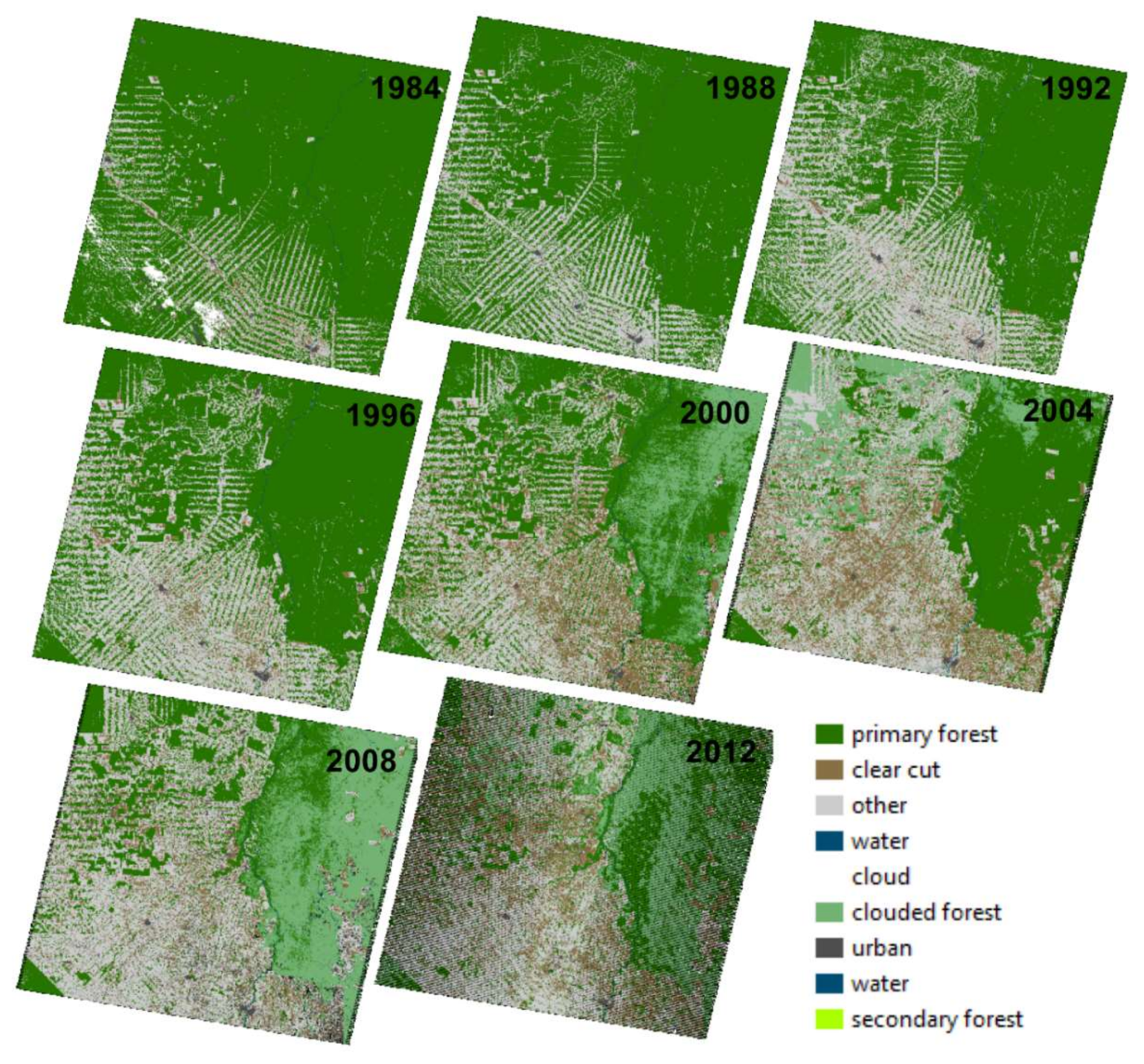
Uses of remote sensing to detect the effects of 20th and 21st century history in the Amazon are widespread, but have focused mainly on the later part of the 20th century due to the advent of remote sensing data [43,44]. Since the early 1970s the Amazon has become increasingly urbanized [58], with fractions of urban population increasing from 35.5% of the total population in the region, to 69% in 2000, and this value is still growing [9]. Despite these large increases, information to describe the human population and its distribution is limited [58]. A proxy that has been used is the detection of spatial patterns of human settlement. Human settlements in modern history of the Amazon follow a characteristic spatial pattern, so-called ‘fishbone’ development (Figure 3). This pattern of settlement is indicative of when settlers arrive and establish in parts of the forest [59], and was first described using the National Oceanic and Atmospheric Administration satellite Advanced Very High Resolution Radiometer (AVHRR) data for a region of 100 × 400 km in Rondônia, Brazil. Skole and Tucker [60] showed, for the first time, the patterns and extent of deforestation of the Amazon using a combination of Landsat Thematic Mapper and SPOT data. More recently, Batistella et al. [61] used Landsat TM to compare patterns of modern settlement in a part of the Brazilian Amazon and showed how different patterns of settlement can result in different deforestation patterns. With an alternative approach, Amaral et al. [58] used data from the Defense Meteorological Satellite Program/Operational Linescan System (DMSP/OLS) over the Amazon region to detect light-demanding activities such as urban settlements, mining and civil construction. They showed that all urban settlements with >10,000 people were detected, 85% of settlements with 5000–10,000 people were detected, and much lower success was achieved for settlements with <5000 people [58]. Tucker et al. [59] also inspected radar imagery for the same area in Rondônia, but were only able to detect minor scattered forest disturbance due to human settlements; however, more modern systems are much more suited to this as noted below. More recently, Lu et al. [62] have proposed an integration of Landsat TM and radar (i.e., ALOS PALSAR L-band and RADARSAT-2 C-band) data to map impervious surfaces with a spatial resolution of 10 m at the urban-rural interface in the Amazon, but achieved similar results to when mapping impervious surfaces with only radar. There are, therefore, promising new avenues to integrate data from multiple sensors to obtain better representations and mapping of current and expansion patterns of settlements in the Amazon. The older or more subtle the surface changes and features are, the more difficult they will be to detect from single-date or single sensor remote sensing data.
2.2. Linear Infrastructure
Built linear infrastructure like roads, bridges, fish weirs, dikes, etc., can also be found in and around Amazonian settlements. These structures represent how societies have moved, have communicated within, and between, settlements and (eventually) societies, and in some cases managed the land for specific purposes. For example, Heckenberger et al. [45] used aerial photography to visually identify a network of pre-Columbian settlements over an area of about 250 km2 connected by roads and bridges in and around them. Another example of detection of linear infrastructures within settlements is by Lombardo et al. [64] in the earth mounds of Llanos de Moxos in Bolivia. They visually identified paleo-levees and water-logged fields from contemporary aerial photographs and hypothesized that these structures allowed the early settlements to subsist and transport water to their households and maintain agricultural areas. Rossetti et al. [65] used Landsat TM and ETM+ data along with sedimentology records to map the drainage network in Marajó Island, at the mouth of the Amazon delta. These authors used various combinations of Landsat bands to highlight forest areas, and they postulated that forests in this open area could only have developed over paleo-channels. Erickson et al. [46] conducted visual inspection of aerial photographs over the Bolivian Amazon and showed linear structures with a zigzag pattern made of raised earth covering distances of up to 3.5 km. There, fisheries were the main food source in the societies of this region in a period estimated between AD 1490–AD 1530 [46]. Finally, early human occupation geoglyphs, are per definition linear structures and have been detected both with visual inspection of aerial photographs [18] and more recently with LiDAR [21].
The colonial and imperial periods came with some development of linear infrastructure [42,56,57], but to our knowledge remote sensing has been little-used in detecting and mapping these routes. During these periods, most transport was via the vast network of rivers in the Amazon basin and it is clear from the known reconstructions of settlements (Figure 2). It is still unclear whether explorers moved in the interior of the Amazon [37,40].
The modern historical period has seen the rapid growth of linear infrastructure development, as exemplified by the fishbone pattern described in the previous section. From 1970 to 2000, more than 80,000 km of roads were built by the Brazilian government [66], but in many cases, roads were first opened illegally to facilitate access to mining and other forest activities [38,44]. For example, Brandão Jr. and Souza Jr. [66] used Landsat data to digitize three categories of roads (visible, fragmented, and partially visible), showing a growth rate of 40 km/10,000 km2 per year between 1996 and 2001. Mapping roads under the dense canopy of the tropical forest is still a challenge, and new systematic methods might be needed that integrate optical, LiDAR and radar, although this approach might be limited by spatial resolution and complexity of the road network (Figure 3). If successful however, detected roads could be validated and fused with existing road maps like the Global Roads dataset of NASA (http://sedac.ciesin.columbia.edu/data/set/groads-global-roads-open-access-v1), Brazilian scientific organizations like IMAZON—Instituto do Homem e do Meio Ambiente da Amazônia (Institute of the Man and Environment of the Amazon; http://imazon.org.br/), and citizen science initiatives like OpenStreetMap (openstreetmap.org).
3. Natural Infrastructure
Land Cover and Land Use
We know that human use of forest products dates back to pre-Columbian times [24], and some areas in South America are centers of domestication, for example of cotton, sweet potato, potato, quinoa, etc. [67]. The use or the domestication of plant species may have shaped the current distribution of some species like Brazil nut (Bertholletia excelsa; [68]), and bamboo (Guadua spp.; [20] but note that the distribution of bamboo around the archaeological sites in Acre, Peru in Western Amazonia is natural). However, to our knowledge these studies have yet to use remote sensing technologies.
Pre-Columbian agriculture has been detected from a specific type of soils named terra preta de indio or Amazonian dark earth [39,69,70]. These soils have high concentrations of nitrogen, phosphorus, and calcium [39], leading to differences in vegetation composition and structure, potentially leading to doubled plant biomass [71]. While we know the approximate locations of these soils [70], the use of remote sensing to detect them, particularly in the optical domain, has been limited because the properties of these soils do not necessarily translate into a distinctive canopy structure. If there were soil impacts on forest structure, particularly height and vertical distribution, then this might be detectable via LiDAR and radar. Furthermore, both upcoming missions NASA GEDI LiDAR (in 2018) and ESA BIOMASS P-band radar (in 2022) ought to be able to detect large differences in above-ground biomass. These characteristic terra preta de indio soils also indicated the use of forests as a source of energy in the form of firewood and charcoal [39].
Phytoglyphs, i.e., ‘drawings’ with vegetation have been linked to early human agriculture in the Amazon. Iriarte et al. [71] have shown that Pre-Columbian raised fields in French Guiana left patterns detectable both in red-green-blue (RGB) and color infrared (CIR) aerial photographs; similar structures were detected in other parts of the Amazon [37]. This is an area where new remote sensing data and techniques might well shed new light on human developments. Geoglyphs, on the other hand, are indications of early human engineering of the landscape to manage natural infrastructure such as fisheries [45]. Previous work used visual inspection of aerial photos for their detection, but more automated and quantitative approaches using UAV LiDAR are now being developed [72]. Roosevelt [16] used radar to show the old floodplain of the Marajó island, and the floodplain contours dictated vegetation boundaries and communities.
Perhaps the most extensive application of remote sensing to study human influence in the Amazon has been the use of optical, LiDAR, and radar data to study 20th and 21st century land use change and its effects on forest functioning [10,11,12,43,44]. We know that livelihoods in modern Brazilian Amazonia are dependent on many non-timber forest products [73], food or medicines for extractivists’ own use. Optical and radar remote sensing data have been extensively used in studying modern land cover [43] and land use changes [44], and the dynamics of deforestation [11,12] in the Amazon and other tropical forests. The first studies on tropical forest vegetation in the 1990s used Landsat-MSS imagery to detect and map tropical rain forest in the Peruvian Amazon [74]; this study used supervised classification on three case study areas and was not very successful in delimiting forest types, or distinguishing between primary forest and agriculture. Simultaneously, there were other attempts to classify Landsat data to obtain a map of the vegetation of the Amazon [75] and using alternative multispectral data such as that from SPOT to map forest degradation [76]. Others, such as Saatchi et al. [43] have opted for radar, in particular data from the Japanese Earth Resources Satellite (JERS-1), to map five land cover types (terra firme forest, savanna, inundated vegetation, open deforested areas and open water). They obtained a 78% classification accuracy when compared to the vegetation maps produced by the project RADAMBRASIL (https://daac.ornl.gov/LBA/guides/Pre_LBA_RADAMBrasil.html) that were based on phytosociological maps from the IBGE—Instituto Brasileiro de Geografia e Estatistica produced in 1992 and aerial photograph interpretation. Asner et al. [44] classified an extensive set of Landsat scenes covering the Amazon, unveiling how deforestation was increasing due to logging activities.
Today, many remote sensing data types from a wide variety of sensors are used to report on deforestation activities. For example, the Landsat archive is used to produce data sets on tree cover loss and gain available in the Global Forest Watch (https://www.globalforestwatch.org/) that can then be used to assess deforestation. Remote sensing data are also used to assess how deforestation rates affect Earth system processes and state shifts towards a disturbance-dominated regime [77]. For example, Kultonov et al. [78] used MODIS to track deforestation over the Mato Grosso region in southern Amazon from 2000 to 2002, and showed how selective logging changes forest phenology. These authors showed how partial clearing leads to a decrease in forest greening during the dry season and results in seasonal losses in canopy moisture and greenness. Another impact of current human presence in the Amazon is the increase in fire incidence. Asner and Alencar [79] reviewed the remote sensing capabilities to detect fire in the Amazon and concluded that there is a need for alternative remote sensing observation capabilities, to complement existing data types, to overcome the impacts of cloud cover (particularly on optical and LiDAR systems) and the complexities of fire in the Amazon.
The link between human presence and biodiversity is not yet fully resolved and not straightforward, especially when it comes to long-term changes to forest structure due to influence since pre-Columbian times. As exemplified in the previous paragraph, there have been many studies assessing the influence of human activities such as deforestation, shifting cultivation, fire, etc. on forest structure as, for example, by detecting forest gaps and secondary forest [10]. However, since we wanted to highlight the continuum of human presence rather than focusing on late 20th century and early 21th century effects, we opted to describe more in depth the knowledge and the gap therein in the human influence throughout different historical periods, highlight early human influences as well as other biophysical factors which could explain natural variation. For example, a recent study using Laser-directed imaging spectroscopy showed how natural fine-scale geomorphological features are strong drivers of the overlying forest structure and composition [80]. This suggests that we need to make better use of the existing archive, as well as developing current and future remote sensing capabilities to truly understand the rich history of land tenure and use in the Amazon. This can help us unpick the impacts of occupation by multiple societies with complex structures, along with the natural processes that determine the Amazonian ecosystem that we know today.
4. Technological and Scientific Perspectives
We are only now starting to unravel the history of settlement structure and dynamics in the Amazon and the implications for its future biodiversity, functioning, and sustainability. Recent studies have shown that even by mapping only a tiny fraction of Amazonia, a great deal of evidence of past activities by human populations has been unraveled. There is, therefore, a large gap in our knowledge of human settlements and their uses of the land throughout the history of the Amazon. Given the widespread presence of ethnical groups and cultures in the Amazon, it can be expected that many archeological dwellings are yet undetected. Archaeological studies have greatly benefited from crucial data provided by Space Agencies over the last 40 years. NASA has greatly contributed to archaeological discovery [81] and the European Space Agency (ESA) has a recent program dedicated to archaeological applications (http://copernicus.eu/news/cultural-heritage-satellites-preserve-our-past).
As reviewed in the previous sections, archaeological dwelling detection has relied on either visual inspection of deforested areas or detecting human presence under the canopy. Visual inspection requires prior knowledge, is time consuming, and relies heavily on prior (untested) assumptions and local calibration. Automation of this process ought to be possible and would be a step forward in quantitative application of remote sensing to this problem. For example, it would be possible to use data from [11] (or others) to select deforested areas and apply widely-used automated pattern recognition techniques, such as moving window approaches [82], detecting local maxima [83], etc. This kind of automated approach could potentially detect previously unknown built infrastructure and validate the presence of known infrastructure. Similarly, anomaly detection could be applied to satellite LiDAR and radar data especially under the dense tropical forest canopies. Very accurate digital elevation models (DEM) from radar and LiDAR are the first tools that provide solid evidence of humans shaping the landscape through linear features, earthworks, and dwellings. These structures are much stronger evidence of human presence than purely top-of-canopy spectral features and they require fewer assumptions about causality. The use of these technologies and data in archaeology has been recognized, with first uses of radar dating back to the 1980s [48]. The more automated this process becomes, the more it can be applied to the increasing archive of data we have already, new and growing archives from ESA’s Sentinel programmes, and other new and forthcoming satellite missions (e.g., NASA GEDI LiDAR mission in 2018, ESA BIOMASS P-band radar in 2021, and NASA-ISRO NISAR optical and L- and S-band radar in 2021).
Especially promising is the growing interest in using LiDAR for archaeological research. LiDAR has the potential to expand dramatically our ability to detect infrastructure under the canopy and map human presence in the entire extent of the Amazon, and Mid-American tropical forest in general. This would be a step-change in our understanding of the history of settlement and effects on the biodiversity of the region. Pingel et al. [84] proposed a workflow to use LiDAR to detect archaeological sites under the canopy, which is an improvement over the use of conventional DEMs, digital canopy models (DCM) and digital surface models (DSM). This is because infrastructure, archaeological or from other periods in history, might be detected in the retrievals that are neither ground nor canopy (Figure 4; [85]). This approach, however, might not be able to discriminate easily between low-stature archaeological features and ground retrievals [86]. Reese-Taylor et al. [87] showed that about 43% of the identified features in LiDAR retrievals were excellent at detecting archaeological features. Further, elevation is often used as a proxy for age of settlement and intensity of use [88], so improved LiDAR retrievals might also contribute better capabilities for dating detected sites. LiDAR for archaeological research would likely be improved by integrating LiDAR in UAVs, providing higher spatial resolution data to detect archaeological features of small size and improve detection accuracy. Airborne LiDAR scanning (ALS) data tends to have a point density of a few to a few 10 s pts/m2, with footprint sizes from a few cm to 10 s cm, depending on the system, flying altitude and speed, ALS system etc. UAV-mounted LiDAR can exceed many 100s of pts/m2, with smaller footprint sizes, but at the cost of much smaller coverage. In both cases, the greatest limitations in remote Amazonian regions may be due to access and cost. Access is still an issue, as a small aircraft needs a landing site with respective facilities within a few kilometers of the site being imaged. Further, permits both from official and indigenous groups are necessary and may be difficult to obtain. Costs of such an operation might be very high, but given the discovery potential they might be worth the investment to obtain a 3D map over the entire region. An additional benefit is that for human settlement mapping there is no need for temporal repeat as historical settlements might be resolved by one acquisition. This airborne acquisition could also serve as a bridge across scales, from airborne to satellite, and from airborne to UAV LiDAR. This latter technology could be an alternative to airborne LiDAR as it does not have the same requirements for permits and landing areas. UAV LiDAR is costly at the moment and requires expensive field campaigns to access remote areas, retrieve the data, store it and upload it to a secure platform. However, UAV LiDAR costs are coming down rapidly, in turn driving the development and availability of new tools for analyzing the data. Additional data sources are emerging and might overcome some of the issues with airborne or UAV LiDAR. The ESA BIOMASS radar (2022) and the NASA GEDI LiDAR mission (2018) are both capable of detecting changes in vegetation height (and likely to resolve infrastructure height, as well) but will have relative large footprints of 50 m (BIOMASS, but imaging) and 20 m (GEDI, non-continuous spot coverage). NASA-ISRO NISAR optical and L- and S-band radar in 2021 will not be able to penetrate dense canopies, but when it does, it will produce good data on land surface likely useable for human infrastructure detection.
Validation of automated detection, using LiDAR or other systems, is likely to also require additional effort, especially in dense and inaccessible tropical forests. Campaign-based terrestrial laser scanner (TLS) observations may provide additional, very detailed validation of archaeological or other human infrastructure, but require prior knowledge of locations to be sampled, and then the increased costs and time of field measurement. There are additional limitations to systematic detection of infrastructure with remote sensing, namely clouds and dense forest. Clouds are not such a significant problem, as for detection of historic infrastructure we only need a one-time acquisition, unlike other remote sensing applications focusing on changes in time. We discussed above how LiDAR and radar might overcome the canopy density issue, which is not possible with current optical systems. The limitation is, however, that impacts are probably much stronger in the forest structure rather than the optical domain impacts, which are likely to be very difficult to see. Furthermore, it is important to account for seasonal and climatic effects in the detected features, especially when detecting natural infrastructure.
Continued provision of these and new types of satellite and airborne data, particularly free of charge (which is not a given), is revolutionizing our ability to detect and attribute early human influence in the Amazon. There is work to be done to build up a picture of where we know the impacts are and measure them, and then these could become test cases for a more systematic identification of other sites. From a remote sensing perspective, we need to develop a semi-empirical model of the signal as measured by the satellite. We also need to better understand how a change in signal relates to impacts and to their change. Once this information is gathered, machine learning might be used to classify the impacts on forests and which ones are mislabeled or missed. Through these steps we will be able to expand beyond where the impacts are very dramatic, which we already know, to other areas where we do not know, and build towards being able to make some predictions of human presence impacts on biodiversity. This also requires some work, as there is a need to identify commonalities in human impacts and a framework for analysis, detailing how (some) of the impacts from different civilizations might affect biodiversity [27]. These predictions can then be made testable and expandable to other regions.
5. Conclusions
Reconstructing human presence and its influence in the Amazon is extremely challenging. Human presence in the tropical rainforests of the Amazon dates back 13,000 years [15], and the changes and impacts of this presence spurred a recent debate [22,23,24,25] with mounting evidence that the impact was localized. Intact forests are of exceptional value [89], but there is growing evidence that different human presence at different points in time have had multiple, varying effects on biodiversity [27]. Here we have shown examples of state-of-the-art knowledge of Amazon human presence at different points in time. We also show how remote sensing is increasingly used to detect and quantify the impacts of 13,000 years of human presence on what we know about the biodiversity, ecosystem function, and service-providing potential of the Amazon. Developing and extending how we use this technology for this particular application will provide more systematic approaches and methods to complement existing knowledge, not only in Pre-Columbian, but also in the Post-Columbian to modern periods. Technological advances and uses of existing and upcoming remotely-sensed data can aid in this understanding, especially when integrated with archaeological and historical in situ data. Indigenous peoples and local communities currently, and in the past, have subsisted on a range of biodiversity-based systems. It is vital, therefore, to understand how Neotropical forest biodiversity has developed in the presence of people in the past, the implications of this for predicting future directions of change in the Amazon and elsewhere [27], and how best to inform policies intended to mitigate or limit their effects and to be inclusive of nature’s value to people [9].
Author Contributions
Conceptualization: M.J.S., M.D., and J.C.; methodology: M.J.S., M.D., and J.C.; formal analysis: M.J.S.; investigation: M.J.S., M.D., and J.C.; writing—original draft preparation: M.J.S., M.D., and J.C.; writing—review and editing, M.J.S., M.D., and J.C.
Funding
M.J.S. is supported by the University Research Priority Program in Global Change and Biodiversity and the Department of Geography from the University of Zürich, and received funds from the Copernicus Institute for Sustainable Development, Utrecht University, The Netherlands. M.D. received funding from the NERC National Centre for Earth Observation (NCEO) for travel and capital funding for LiDAR equipment; M.D. is supported, in part, by NERC Standard Grants NE/N00373X/1, NE/P011780/1, and the European Union’s Horizon 2020 research and innovation programme under grant agreement no. 640176 for the EU H2020 BACI project. J.C. is supported by the Laboratoire Evolution et Diversité Biologique (EDB), and by funds from CNES and the European Space Agency.
Acknowledgments
This work has benefited from a “Investissement d’Avenir” grant managed by the French Agence Nationale de la Recherche (CEBA, ref. ANR-10-LABX-25-01). The authors are thankful to Janes Jorge, Luis Ferla, and Tiago Gil for all the discussions about Brazilian history. The authors are also thankful to David Small from the Remote Sensing Laboratories at the Department of Geography at the University of Zurich for his suggestions regarding radar.
Conflicts of Interest
The authors declare no conflict of interest. The founding sponsors had no role in the design of the study; in the collection, analyses, or interpretation of data; in the writing of the manuscript; or in the decision to publish the results.
References
- Dirzo, R.; Raven, P.H. Global State of Biodiversity and Loss. Ann. Rev. Env. Res. 2003, 28, 137–167. [Google Scholar] [CrossRef]
- Da Silva, J.M.C.; Rylands, A.B.; da Fonseca, G.A.B. The fate of the Amazonian areas of endemism. Conserv. Biol. 2005, 19, 689–694. [Google Scholar] [CrossRef]
- Junk, W.J.; Soares, M.G.M.; Bayley, P.B. Freshwater fishes of the Amazon River basin: Their biodiversity, fisheries and habitats. Aquat. Ecosyst. Health Manag. 2007, 106, 110–127. [Google Scholar] [CrossRef]
- Houghton, R.A.; Skole, D.L.; Nobre, C.A.; Hackler, J.L.; Lawrence, K.T.; Chomentowski, W.H. Annual fluxes of carbon from deforestation and regrowth in the Brazilian Amazon. Nature 2000, 403, 301–304. [Google Scholar] [CrossRef] [PubMed]
- Achard, F.; Beuchle, R.; Mayaux, P.; Stibig, H.-J.; Bodart, C.; Brink, A.; Carboni, S.; Desclee, B.; Donnay, F.; Eva, H.D.; et al. Determination of tropical deforestation rates and related carbon losses from 1990 to 2010. Glob. Chang. Biol. 2014, 20, 2540–2554. [Google Scholar] [CrossRef] [PubMed] [Green Version]
- Durieux, L.; Machado, L.A.T.; Laurent, H. The impact of deforestation on cloud cover over the Amazon arc of deforestation. Remote Sens. Environ. 2003, 86, 132–140. [Google Scholar] [CrossRef]
- Cheng, H.; Sinha, A.; Cruz, F.W.; Wang, X.; Edwards, R.L.; d’Horta, F.M.; Ribas, C.C.; Vuille, M.; Stott, L.D.; Auler, A.S. Climate change patterns in Amazonia and biodiversity. Nature 2013, 4, 1–6. [Google Scholar] [CrossRef] [PubMed]
- Coe, M.T.; Costa, M.H.; Soares-Filho, B.S. The influence of historical and potential future deforestation on the stream flow of the Amazon River—Land surface processes and atmospheric feedbacks. J. Hydr. 2009, 369, 165–174. [Google Scholar] [CrossRef]
- IPBES—Intergovernmental Panel on Biodiversity and Ecosystem Services. Summary for Policymakers of the Regional Assessment Report on Biodiversity and Ecosystem Services for the Americas of the Intergovernmental Science-Policy Platform on Biodiversity and Ecosystem Services; Rice, J., Seixas, C.S., Zaccagnini, M.E., Bedoya-Gaitán, M., Valderrama, N., Anderson, C.B., Arroyo, M.T.K., Bustamante, M., Cavender-Bares, J., Eds.; IPBES Secretariat: Bonn, Germany, 2018. [Google Scholar]
- Malhi, Y.; Roberst, J.T.; Betts, R.A.; Killeen, T.J.; Li, W.; Nobre, C.A. Climate Change, deforestation, and the fate of the Amazon. Science 2008, 319, 169–172. [Google Scholar] [CrossRef] [PubMed]
- Tyukavina, A.; Hansen, M.C.; Potapov, P.V.; Stehman, S.V.; Smith-Rodriguez, K.; Okpa, C.; Aguilar, R. Types and rates of forest disturbance in Brazilian Legal Amazon, 2000-2013. Science Adv. 2017, 3, e1601047. [Google Scholar] [CrossRef] [PubMed]
- Taubert, F.; Fischer, R.; Groeneveld, J.; Lehmann, S.; Müller, M.S.; Rödig, E.; Wiegand, T.; Huth, A. Global patterns of tropical forest fragmentation. Nature 2018, 553, 519–522. [Google Scholar] [CrossRef] [PubMed]
- Wearn, O.R.; Reuman, D.C.; Ewers, R.M. Extinction debt and windows of conservation opportunity in the Brazilian Amazon. Science 2012, 337, 228–232. [Google Scholar] [CrossRef] [PubMed]
- Malhi, Y.; Gardner, T.A.; Goldsmith, G.R.; Silman, M.R.; Zelazowski, P. Tropical forests in the Anthropocene. Ann. Rev. Environ. Resour. 2014, 39, 125–159. [Google Scholar] [CrossRef]
- Foley, J.A.; Asner, G.P.; Costa, M.H.; Coe, M.T.; DeFries, R.; Gibbs, H.K.; Howard, E.A.; Olson, S.; Patz, J.; Ramankutty, N.; et al. Amazonia revealed: Forest degradation and loss of ecosystem goods and services in the Amazon Basin. Front. Ecol. Evol. 2007, 5, 25–32. [Google Scholar] [CrossRef]
- Roosevelt, A.C. The Amazon and the Anthropocene: 13,000 years of human influence in a tropical rainforest. Anthropocene 2013, 4, 69–87. [Google Scholar] [CrossRef]
- Skoglund, P.; Reich, D. A genomic view of the peopling of the Americas. Curr. Opin. Genet. Dev. 2016, 41, 27–35. [Google Scholar] [CrossRef] [PubMed] [Green Version]
- McKey, D.; Rostain, S.; Iriarte, J.; Glaser, B.; Birk, J.J.; Holst, I.; Renard, D. Pre-Columbian agricultural landscapes, ecosystem engineers, and self-organized patchiness in Amazonia. Proc. Natl. Acad. Sci. USA 2010, 107, 7823–7828. [Google Scholar] [CrossRef] [PubMed] [Green Version]
- McMichael, C.H.; Palace, M.W.; Bush, M.B.; Braswell, B.; Hagen, S.; Neves, E.G.; Silman, M.R.; Tamanaha, E.K.; Czarnecki, C. Predicting pre-Columbian anthropogenic soils in Amazonia. Proc. R. Soc. Lond. B 2014, 281, 20132475. [Google Scholar] [CrossRef] [PubMed]
- McMichael, C.H.; Palace, M.W.; Golightly, M. Bamboo-dominated forests and pre-Columbian earthwork formations in south-western Amazonia. J. Biogeogr. 2014, 41, 1733–1745. [Google Scholar] [CrossRef]
- Watling, J.; Iriarte, J.; Mayle, F.E.; Schaan, D.; Pessenda, L.C.; Loader, N.J.; Street-Perrott, F.A.; Dickau, R.E.; Damasceno, A.; Ranzi, A. Impact of pre-Columbian “geoglyph” builders on Amazonian forests. Proc. Natl. Acad. Sci. USA 2017, 114, 1868–1873. [Google Scholar] [CrossRef] [PubMed] [Green Version]
- McMichael, C.H.; Feeley, K.J.; Dick, C.W.; Piperno, D.R.; Bush, M.B. Comment of “Persistent effects of pre-Columbian plant domestication on Amazonian forest composition”. Science 2017, 358, eaan8347. [Google Scholar] [CrossRef] [PubMed]
- McMichael, C.H.; Matthews-Bird, F.; Farfan-Rios, W.; Feeley, K.J. Ancient human disturbances may be skewing our understanding of Amazonian forests. Proc. Natl. Acad. Sci. USA 2017, 114, 522–527. [Google Scholar] [CrossRef] [PubMed] [Green Version]
- Levis, C. Persistent effects of pre-Columbian plant domestication on Amazonian forest composition. Science 2017, 355, 925–931. [Google Scholar] [CrossRef] [PubMed] [Green Version]
- Piperno, D.R.; McMichael, C.H.; Bush, M.B. Further evidence for localized, short-term anthropogenic forest alterations across pre-Columbian Amazonia. Proc. Natl. Acad. Sci. USA 2017, 114, E4118–E4119. [Google Scholar] [CrossRef] [PubMed]
- Bush, M.B.; Correa-Metrio, A.; McMichael, C.H.; Sully, S.; Shadik, C.R.; Valencia, B.G.; Guilderson, T.; Steinitz-Kannan, M.; Overpeck, J.T. A 6900-year history of landscape modification by humans in lowland Amazonia. Q. Sci. Rev. 2016, 141, 52–64. [Google Scholar] [CrossRef] [Green Version]
- Šizling, A.L.; Pokorný, P.; Horácková, J.; Abraham, V.; Šizlingová, E.; Lozek, V.; Tjørve, E.; Tjørve, K.M.C.; kunin, W. Can people change the ecological rules that appear general across space? Glob. Ecol. Biogeogr. 2016, 25, 1072–1084. [Google Scholar] [CrossRef] [Green Version]
- Carneiro da Cunha, M. História dos Indios no Brasil; Companhia das Letras: São Paulo, Brasil, 1992; 656p. [Google Scholar]
- Carneiro da Cunha, M. Indios no Brasil—Historia, Direitos e Cidadania; Companhia das Letras: Claro Enigma Publicações, Brazil, 2012. [Google Scholar]
- Watling, J.; Iriarte, J. Phytoliths from the coastal savannas of French Guiana. Q. Int. 2013, 287, 162–180. [Google Scholar] [CrossRef]
- Heckenberger, M.J.; Neves, E.G. Amazonian archaeology. Annu. Rev. Anthropol. 2009, 38, 251–266. [Google Scholar] [CrossRef]
- Rostain, S. Islands in the Rainforest: Landscape Management in Pre-Columbian Amazonia; Left Coast Press: Walnut Creek, CA, USA, 2012. [Google Scholar]
- Whitney, B.S.; Dickau, R.; Mayle, F.E.; Soto, J.D.; Iriarte, J. Pre-Columbian landscape impact and agriculture in the Monumental Mound region of the Llanos de Moxos, lowland Bolivia. Q. Res. 2013, 80, 207–217. [Google Scholar] [CrossRef]
- Denevan, W.M. Estimating Amazonian Indian Numbers in 1492. J. Lat. Am. Geogr. 2014, 13, 207–221. [Google Scholar] [CrossRef]
- Clement, C.R.; Denevan, W.M.; Heckenberger, M.J.; Junqueira, A.B.; Neves, E.G.; Teixeira, W.G.; Woods, W.I. The domestication of Amazonia before European conquest. Proc. R. Soc. Lond. B 2015, 282, 20150813. [Google Scholar] [CrossRef] [PubMed] [Green Version]
- Goldberg, A.; Mychajliw, A.M.; Hadly, E.A. Post-invasion demography of prehistoric humans in South America. Nature 2016, 532, 232–235. [Google Scholar] [CrossRef] [PubMed]
- Heckenberger, M. Who is Amazonia? The ‘salt of the matter’ for indigenous sustainability. Environ. Res. Lett. 2013, 8, 015034. [Google Scholar] [CrossRef]
- Rodrigues, A.S.L.; Ewers, R.M.; Parry, L.; Souza, C., Jr.; Verissimo, A.; Balmford, A. Boom-and-bust development patterns across the Amazon deforestation frontier. Science 2008, 324, 1435–1437. [Google Scholar] [CrossRef] [PubMed]
- Glaser, B.; Birk, J.J. State of the scientific knowledge on properties and genesis of Anthropogenic dark earths in central Amazonia (terra preta de indio). Geochim. Cosmochim. Acta 2012, 82, 39–51. [Google Scholar] [CrossRef]
- Fausto, C. Os Indios Antes do Brasil; Zahar Editora: Rio de Janeiro, Brazil, 2000; 94p. [Google Scholar]
- Mayle, F.E.; Iriarte, J. Integrated palaeoecology and archaeology—A powerful approach for understanding pre-Columbian Amazonia. J Archaeo Scien 2014, 51, 54–64. [Google Scholar] [CrossRef]
- Luttembark, C. Retratos do Outro: As Fotografias Antropológicas da Expedição Thayer e da Comissão Geológica do Império do Brazil (1865–1877). Master’s Thesis, Federal University of Minas Gerais, Belo Horizonte, Brazil, 2010. [Google Scholar]
- Saatchi, S.S.; Nelson, B.; Podest, E.; Holt, J. Mapping land cover types in the Amazon Basin using 1 km JERS-1 mosaic. Int. J. Remote Sens. 2000, 21, 6–7. [Google Scholar] [CrossRef]
- Asner, G.P.; Knapp, D.E.; Broadbent, E.N.; Oliveira, P.J.C.; Keller, M.; Silva, J.N. Selective logging in the Brazilian Amazon. Science 2005, 310, 480–482. [Google Scholar] [CrossRef] [PubMed]
- Heckenberger, M.J.; Russell, J.C.; Fausto, C.; Toney, J.R.; Schmidt, M.J.; Pereira, E.; Franchetto, B.; Kuikuro, A. Pre-Columbian urbanism, anthropogenic landscapes, and the future of the Amazon. Science 2008, 321, 1214–1217. [Google Scholar] [CrossRef] [PubMed]
- Erickson, C.L. An artificial landscape-scale fishery in the Bolivian Amazon. Nature 2000, 408, 190–193. [Google Scholar] [CrossRef] [PubMed]
- Pärssinen, M.; Schaan, D.; Ranzi, A. Pre-Columbian geometric earthworks in the upper Purús: A complex society in western Amazonia. Antiquity 2009, 83, 1084–1095. [Google Scholar] [CrossRef]
- Lombardo, U.; Prümers, H. Pre-Columbian human occupation patterns in the eastern plains of the Llanos de Moxos, Bolivian Amazonia. J. Archaeol. Sci. 2010, 37, 1875–1885. [Google Scholar] [CrossRef]
- Ranzi, A.; Feres, R.; Brown, F. Internet software programs aid in search for Amazonia Geoglyphs. EOS Trans. Am. Geophys. Union 2007, 88, 226–229. [Google Scholar] [CrossRef]
- Roosevelt, A.C. Mound-Builders of the Amazon: Geophysical Archaeology at the Mouth of the Amazon; Academic: San Diego, CA, USA, 1991; 495p. [Google Scholar]
- Mann, C.C. 1491: New Revelations of the Americas before Columbus; Knopf: New York, NY, USA, 2005. [Google Scholar]
- Galeano, E. The Open Veins of Latin America: Five Centuries of the Pillage of a Continent; Monthly Review Press: New York, NY, USA, 1940; 317p. [Google Scholar]
- Brondizio, E. Landscapes of the past, footprints of the future. In Time and Complexity in Historical Ecology: Studies in the Neotropical Lowlands; Balée, W., Erickson, C.L., Eds.; Columbia University Press: New York, NY, USA, 2006; 432p. [Google Scholar]
- Dull, R.A.; Nevle, R.J.; Woods, W.I.; Bird, D.K.; Avnery, S.; Denevan, W.M. The Columbian encounter and the Little Ice Age: Abrupt land use change, fire, and greenhouse forcing. Ann. Assoc. Am. Geogr. 2010, 100, 755–771. [Google Scholar] [CrossRef]
- Gil, T. Recuperando terreno: O espaço como problema de pesquisa em história colonial. Locus Revista de História Juiz de Fora 2014, 20, 183–202. [Google Scholar]
- Villa, C.V.; Gil, T. O Retorno dos Mapas: Sistemas de Informação Geográfica em História; Ladeira Livros: Porto Alegre, Brazil, 2016; 516p. [Google Scholar]
- Ramalho, J.P.G. A Produção para Consumo Interno na Amazônia da Segunda Metade do Século XVIII: Da Historiografia à Análise do Abastecimento no vale do rio Tocantins. Master’s Thesis, Universidade of Brasília, Brasília, Brazil, 2017. [Google Scholar]
- Amaral, S.; Monteiro, A.M.V.; Camara, G.; Quintanilha, J.A. DMSP/OLS night-time light imagery for urban population estimates in the Brazilian Amazon. Int. J. Remote Sens. 2006, 25, 855–870. [Google Scholar] [CrossRef]
- Tucker, C.J.; Holben, B.N.; Goff, T.E. Intensive forest clearing in Rondônia, Brazil, as detected by satellite remote sensing. Remote Sens. Environ. 1984, 15, 255–261. [Google Scholar] [CrossRef]
- Skole, D.; Tucker, C. Tropical deforestation and habitat fragmentation in the Amazon: Satellite data from 1978 to 1988. Science 1993, 5116, 1905–1910. [Google Scholar] [CrossRef] [PubMed]
- Batistella, M.; Robeson, S.; Moran, E.F. Settlement design, forest fragmentation, and landscape change in Rondônia, Amazonia. Photogramm. Eng. Remote Sens. 2003, 69, 805–812. [Google Scholar] [CrossRef]
- Lu, D.; Li, G.; Moran, E.; Batistella, M.; Freitas, C.C. Mapping impervious surfaces with the integrated use of Landsat Thematic Mapper and Radar data: A case study in an urban-rural landscape in the Brazilian Amazon. ISPRS J. Photogramm. Remote Sens. 2011, 66, 798–808. [Google Scholar] [CrossRef] [Green Version]
- Rocha, I. Influence of Road Presence in Secondary Forest Regrowth. Master’s Thesis, Utrecht University. Faculty of Geosciences Theses, Utrecht, The Netherlands, 1874. [Google Scholar]
- Lombardo, U.; Denier, S.; May, J.-H.; Rodrigues, L.; Veit, H. Human-environment interactions in pre-Columbian Amazonia: The case of the Llanos de Moxos, Bolivia. Q. Int. 2013, 312, 109–119. [Google Scholar] [CrossRef]
- Rossetti, D.F.; Goes, A.M.; de Toledo, P.M. Archaeological mounds in Marajó Island in Northern Brazil: A geological perspective integrating remote sensing and sedimentology. Geoarchaeol. Int. J. 2009, 24, 22–41. [Google Scholar] [CrossRef]
- Brandão, A.O., Jr.; Souza, C.M., Jr. Mapping unofficial roads with Landsat images; A new tool to improve the monitoring of the Brazilian Amazon rainforest. Int. J. Remote Sens. 2006, 27, 177–189. [Google Scholar] [CrossRef]
- Smith, B.D. Eastern North America as an independent center of plant domestication. Proc. Natl. Acad. Sci. USA 2006, 103, 12223–12228. [Google Scholar] [CrossRef] [PubMed] [Green Version]
- Thomas, E.; Caicedo, C.A.; McMichael, C.H.; Corvera, R.; Loo, J. Uncovering spatial patterns in the natural and human history of Brazil nut. J. Biogeogr. 2015, 42, 1367–1382. [Google Scholar] [CrossRef]
- German, L. Ethnoscientific Understanding of Amazonian Dark Earths. In Amazonian Dark Earths: Origin, Properties, Management; Lehman, J., Kern, D.C., Glaser, B., Woods, W.I., Eds.; Kluwer Academic Publishers: Dodrecht, The Netherlands, 2003. [Google Scholar]
- Kern, D.C.; D’Aquino, G.; Rodrigues, T.E.; Franzão, F.J.L.; Sombroek, W.; Myers, T.P.; Neves, E.G. Distribution of Amazon. In Amazonian Dark Earths: Origin, Properties, Management; Lehman, J., Kern, D.C., Glaser, B., Woods, W.I., Eds.; Kluwer Academic Publishers: Dodrecht, The Netherlands, 2003; 75p. [Google Scholar]
- Iriarte, J.; Power, M.J.; Rostain, S.; Mayle, F.E.; Jones, H.; Watling, J.; Whitney, B.S.; McKey, D.B. Fire-free land use in pre-1492 Amazonian savannas. Proc. Natl. Acad. Sci. USA 2012, 109, 6473–6478. [Google Scholar] [CrossRef] [PubMed] [Green Version]
- Khan, S.; Aragão, L.; Iriarte, J. A UAV-LiDAR system to map Amazonia rainforest and its ancient landscape transformations. Int. J. Remote Sens. 2017, 38, 2313–2330. [Google Scholar] [CrossRef]
- Fearnside, P.M. Extractive reserves in Brazilian Amazonia: An opportunity to maintain tropical rain forest under sustainable land use. BioScience 1989, 39, 387–393. [Google Scholar] [CrossRef]
- Tuomisto, H.; Linna, A.; Kalliola, R. Use of digitally processed satellite images in studies of tropical rain forest vegetation. Int. J. Remote Sens. 1994, 8, 1595–1610. [Google Scholar] [CrossRef]
- Adams, J.B.; Sabol, D.E.; Kapos, V.; Almeida Filho, R.; Roberts, D.A.; Smith, M.O.; Gillespie, A.R. Classification of multispectral images based on fractions of endmembers: Application to land-cover change in the Brazilian Amazon. Remote Sens. Environ. 1995, 52, 137–154. [Google Scholar] [CrossRef]
- Souza Jr., C.; Firestone, L.; Silva, L.M.; Roberts, D. Mapping forest degradation in the Eastern Amazon from SPOT 4 through spectral mixture models. Remote Sens. Environ. 2003, 87, 494–506. [Google Scholar] [CrossRef]
- Davidson, E.A.; Araújo, A.C.; Artaxo, P.; Balch, J.K.; Brown, I.F.; Bustamante, M.M.C.; Coe, M.T.; DeFries, R.S.; Keller, M.; Longo, M.; et al. The Amazon basin in transition. Nature 2012, 481, 321–328. [Google Scholar] [CrossRef] [PubMed]
- Koltunov, A.; Ustin, S.L.; Asner, G.P.; Fung, I. Selective logging changes forest phenology in the Brazilian Amazon: Evidence from MODIS images time series analysis. Remote Sens. Environ. 2009, 113, 2431–2440. [Google Scholar] [CrossRef]
- Asner, G.P.; Alencar, A. Drought impacts on the Amazon forest: The remote sensing perspective. New Phytol. 2010, 187, 569–578. [Google Scholar] [CrossRef] [PubMed]
- Chadwick, K.D.; Asner, G.P. Landscape evolution and nutrient rejuvenation reflected in Amazon forest canopy chemistry. Ecol. Lett. 2018. [Google Scholar] [CrossRef] [PubMed]
- Giardino, M.J. A history of NASA remote sensing contributions to archaeology. J. Archaeol. Sci. 2011, 38, 2003–2009. [Google Scholar] [CrossRef] [Green Version]
- Greenberg, J.A.; Dobrowski, S.Z.; Vanderbilt, V.C. Limitations on maximum tree density using hyperspatial remote sensing and environmental gradient analysis. Remote Sens. Environ. 2009, 113, 94–101. [Google Scholar] [CrossRef]
- Greenberg, J.A.; Dobrowski, S.Z.; Ustin, S.L. Shadow allometry: Estimating tree structural parameters using hyperspatial image analysis. Remote Sens. Environ. 2005, 97, 15–25. [Google Scholar] [CrossRef]
- Pingel, T.K.; Clarke, K.; Ford, A. Bonemapping: A LiDAR processing and visualization technique in support of archaeology under the canopy. Cartagr. Geogr. Inf. Sci. 2015, 42, 18–26. [Google Scholar] [CrossRef]
- Inomata, T.; Pinzon, F.; Ranchos, J.L.; Haraguchi, T.; Nasu, H.; Fernandez-Diaz, J.C.; Aoyama, K.; Yonenobu, H. Archaeological application of airborne LiDAR with Object-Based vegetation classification and visualization techniques at the Lowland Maya site of Ceibal, Guatemala. Remote Sens. 2017, 9, 563. [Google Scholar] [CrossRef]
- Magnoni, A.; STanton, T.W.; Barth, N.; Fernandez-Diaz, J.C.; Leon, J.F.O.; Ruiz, F.P.; Wheeler, J.A. Detection thresholds of archaeological features in airborne LiDAR data from Central Yucatan. Adv. Archaeol. Pract. 2016, 4, 232–248. [Google Scholar] [CrossRef]
- Reese-Taylor, K.; Hernandez, A.A.; Esquivel, F.C.A.F.; Monteleone, K.; Uruarte, A.; Carr, C.; Acuna, H.G.; Fernandez-Diaz, J.C.; Peuramaki-Brown, M.; Dunning, N. Boots on the ground at Yaxnohcah. Adv. Archaeol. Pract. 2016, 4, 314–338. [Google Scholar] [CrossRef]
- Yaeger, J.; Brown, M.K.; Cap, B. Locating and dating sites using LiDAR survey in a mosaic landscape in western Belize. Adv. Archaeol. Pract. 2016, 4, 339–356. [Google Scholar] [CrossRef]
- Watson, J.E.; Evans, T.; Venter, O.; Williams, B.; Tulloch, A.; Stewart, C.; Thompson, I.; Ray, J.C.; Murray, K.; Salazar, A.; et al. The exceptional value of intact forest ecosystems. Nat. Ecol. Evol. 2018, 2, 599–610. [Google Scholar] [CrossRef] [PubMed]
Figure 1.
Examples of RS-enabled detection of pre-historic human activity in Mid-American tropical landscapes: (A) Contemporary and past villages (dashed line) in the Upper Xingu region of the Brazilian Amazon (dashed lines represent past villages, red lines represent known ancient roads and black lines represent ditches; adapted from [45]), (B) Pre-Columbian mounds as interpreted using photo and spectroscopic imagery (adapted from [18]), (C) earth mounds in Acre, Brazil, first exposed by deforestation (left panel adapted from [16]), then using LiDAR technology (right panel; ([21], http://agencia.fapesp.br/)).

Figure 2.
Locations of (a) indigenous and (b) non-indigenous population centers as mentioned in the diaries of Padre Noronha during the colonial period—1500s–1800s (figure reproduced with authorization from J.P. Ramalho and published in [56,57]).

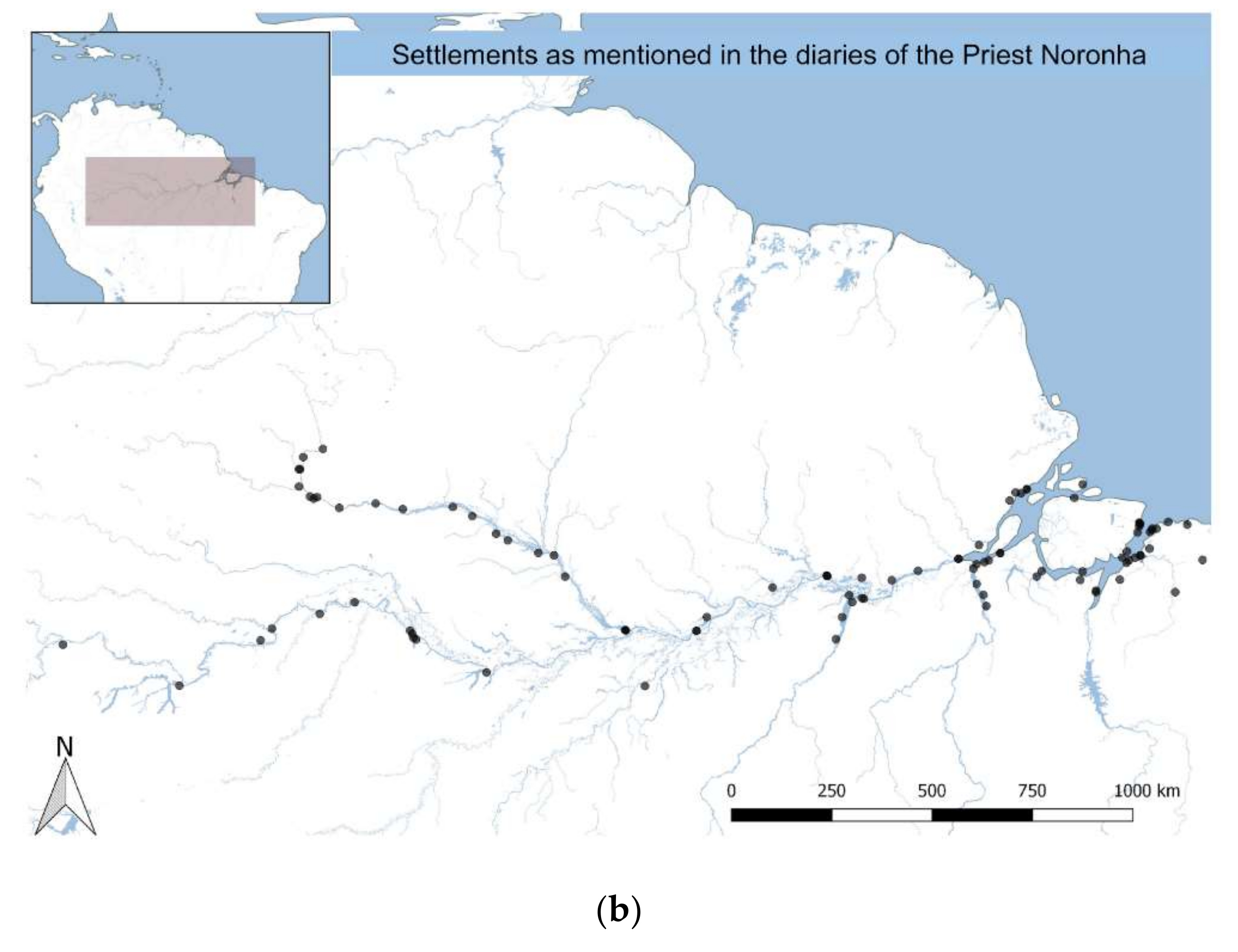
Figure 3.
“Fishbone” road development pattern in Amazonia using Landsat TM data over 28 years. We used land surface reflectance Landsat data and classified it with maximum likelihood algorithm to distinguish the nine most dominant classes in the scene., with classification accuracies of 0.92 ± 0.05, and kappa coefficient 0.85 ± 0.08. Most misclassification occurred for secondary forest, but this is beyond the point of this figure as we use it to illustrate development of the fish-bone pattern over time. In the 2012 image the stripes correspond to the failure in the Scan Line Corrector of Landsat 7 and these were the only ones available for this year (figure from [63]).

Figure 4.
Point clouds from different vegetation types ((a) primary forest; (b) high secondary forest; (c) medium height secondary forest; (d) low secondary forest; and (e) high grass) illustrating, in green, vegetation retrievals and, in orange, ground retrievals. Archaeological sites might be detected using the orange retrievals (figure reprinted with creative commons permission from [85]).

© 2018 by the authors. Licensee MDPI, Basel, Switzerland. This article is an open access article distributed under the terms and conditions of the Creative Commons Attribution (CC BY) license (http://creativecommons.org/licenses/by/4.0/).
Share and Cite
MDPI and ACS Style
Santos, M.J.; Disney, M.; Chave, J. Detecting Human Presence and Influence on Neotropical Forests with Remote Sensing. Remote Sens. 2018, 10, 1593. https://doi.org/10.3390/rs10101593
AMA Style
Santos MJ, Disney M, Chave J. Detecting Human Presence and Influence on Neotropical Forests with Remote Sensing. Remote Sensing. 2018; 10(10):1593. https://doi.org/10.3390/rs10101593
Chicago/Turabian StyleSantos, Maria J., Mathias Disney, and Jérôme Chave. 2018. "Detecting Human Presence and Influence on Neotropical Forests with Remote Sensing" Remote Sensing 10, no. 10: 1593. https://doi.org/10.3390/rs10101593
Note that from the first issue of 2016, this journal uses article numbers instead of page numbers. See further details here.