Vertical Migration of the Along-Slope Counter-Flow and Its Relation with the Kuroshio Intrusion off Northeastern Taiwan

 , ,
, ,
Abstract
:1. Introduction
2. Materials and Methods
2.1. Materials
2.1.1. Study Area
2.1.2. In Situ Observations
2.1.3. Satellite Altimeter Data
2.1.4. MODIS SST Data
2.1.5. The Analysis Data
2.2. Methods
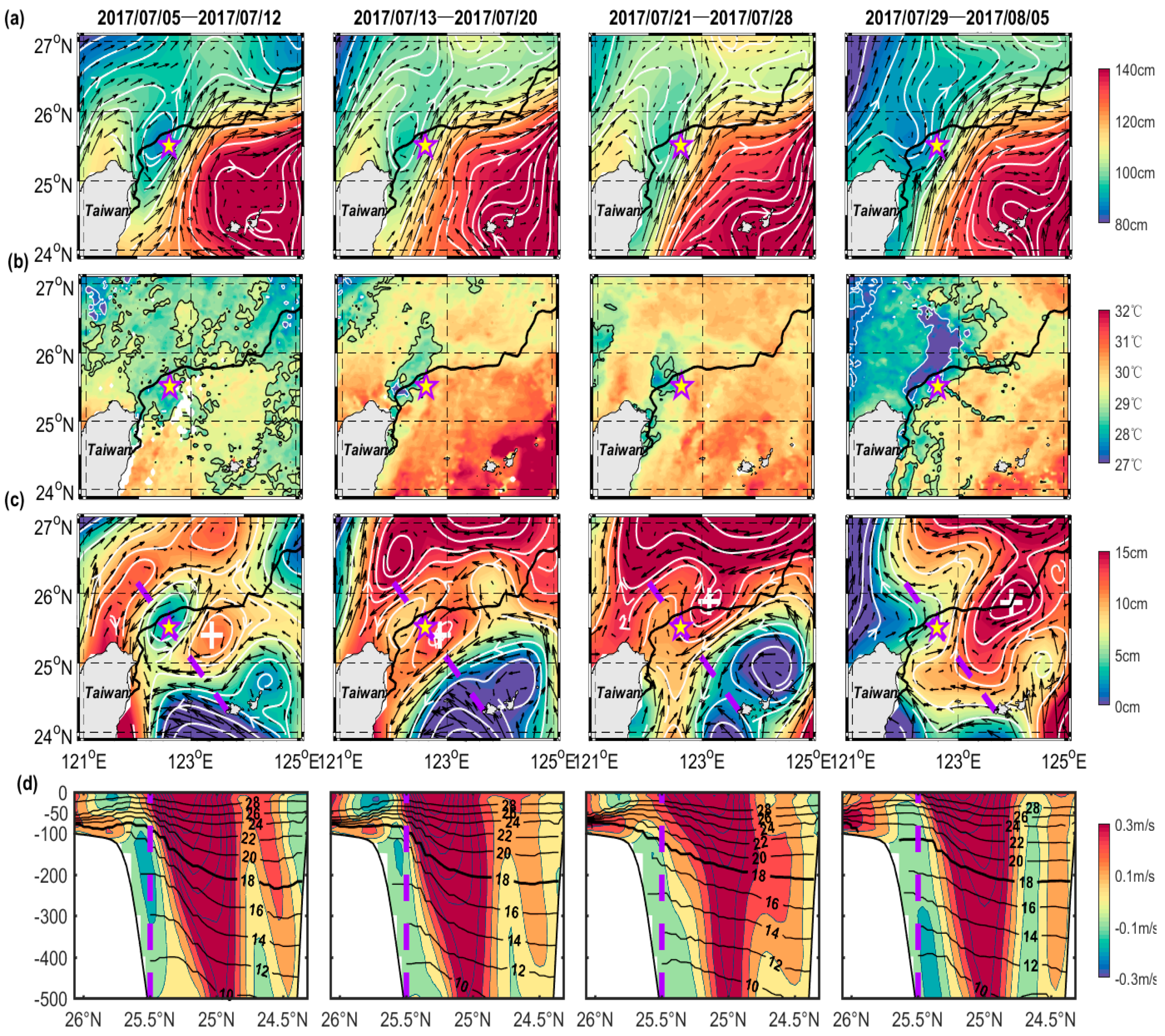
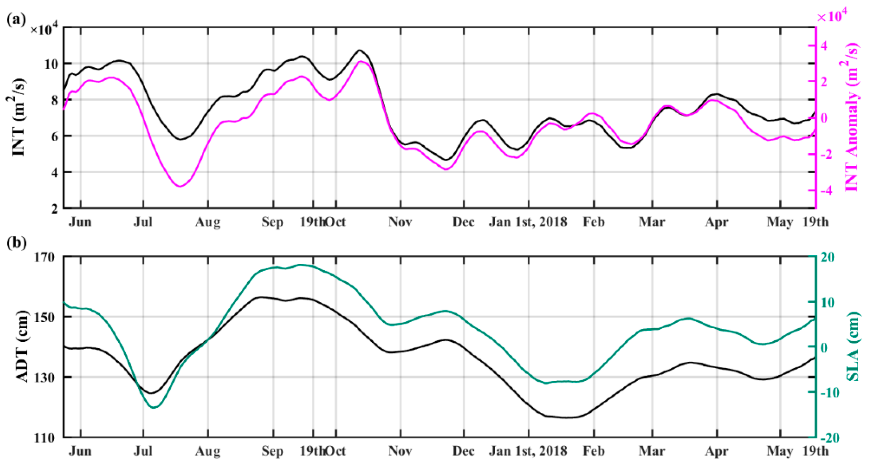
3. Results
3.1. Vertical Migration of the Counter-Flow
3.2. Horizontal and Vertical Patterns
4. Discussion
5. Conclusions
Author Contributions
Funding
Acknowledgments
Conflicts of interest
References
- Andres, M.; Jan, S.; Sanford, T.B.; Mensah, V.; Centurioni, L.R.; Book, J.W. Mean Structure and variability of the Kuroshio from northeastern Taiwan to southwestern Japan. Oceanography 2015, 28, 84–95. [Google Scholar] [CrossRef]
- Hsueh, Y. The Kuroshio in the East China Sea. J. Mar. Syst. 2000, 24, 131–139. [Google Scholar] [CrossRef]
- Hu, D.X.; Wu, L.X.; Cai, W.J.; Gupta, A.S.; Ganachaud, A.; Qui, B.; Gordon, A.L.; Lin, X.P.; Chen, Z.H.; Hu, S.J.; et al. Pacific western boundary currents and their roles in climate. Nature 2015, 522, 299–308. [Google Scholar] [CrossRef] [PubMed]
- Isobe, A. Recent Advances in Ocean-Circulation Research on the Yellow Sea and East China Sea Shelves. J. Oceanogr. 2008, 64, 569–584. [Google Scholar] [CrossRef]
- Wu, C.R.; Wang, Y.L.; Lin, Y.F.; Chao, S.Y. Intrusion of the Kuroshio into the South and East China Seas. Sci. Rep. 2017, 7, 7895. [Google Scholar] [CrossRef]
- Nitani, H. Variation of the Kuroshio South of Japan. J. Oceanogr. Soc. Jpn. 1975, 31, 154–173. [Google Scholar]
- Matsuno, T.; Lee, J.S.; Yanao, S. Influence of the Kuroshio on the water properties in the shelf. Ocean Sci. Discuss. 2009, 6, 741–764. [Google Scholar] [CrossRef]
- Gawarkiewicz, G.; Jan, S.; Lermusiaux, P.F.J.; Mcclean, J.L.; Centurioni, L.; Duda, T.F.; Wang, J.; Yang, Y.J.; Sanford, T.; Lien, R.C.; et al. Circulation and intrusions northeast of Taiwan: Chasing and predicting uncertainty in the cold dome. Oceanography 2011, 24, 111–121. [Google Scholar] [CrossRef]
- Liu, X.H.; Dong, C.M.; Chen, D.K.; Su, J.L. The Pattern and Variability of Winter Kuroshio Intrusion Northeast of Taiwan. J. Geophys. Res. Oceans 2014, 119, 5380–5394. [Google Scholar] [CrossRef]
- Lee, J.S.; Matsuno, T. Intrusion of Kuroshio Water onto the Continental shelf of the East China Sea. J. Oceanogr. 2007, 63, 309–325. [Google Scholar] [CrossRef]
- Yang, D.Z.; Yin, B.S.; Liu, Z.L.; Bai, T.; Qi, J.F.; Chen, H.Y. Numerical study on the pattern and origins of Kuroshio branches in the bottom water of southern East China Sea in summer. J. Geophys. Res. Oceans 2012, 117. [Google Scholar] [CrossRef]
- Yang, D.Z.; Huang, R.X.; Yin, B.S.; Feng, X.R.; Chen, H.Y.; Qi, J.F.; Xu, L.J.; Shi, Y.L.; Cui, X.; Gao, G.D.; et al. Topographic Beta Spiral and Onshore Intrusion of the Kuroshio current. Geophys. Res. Lett. 2018, 45, 287–296. [Google Scholar] [CrossRef]
- Yang, D.Z.; Yin, B.S.; Chai, F.; Feng, X.R.; Xue, H.J.; Gao, G.D. The Onshore Intrusion of Kuroshio Subsurface Water from February to July and a Mechanism for the Intrusion Variation. Prog. Oceanogr. 2018, 167, 97–115. [Google Scholar] [CrossRef]
- Lie, H.J.; Cho, C.H. Recent advances in understanding the circulation and hydrography of the East China Sea. Fish. Oceanogr. 2002, 11, 318–328. [Google Scholar] [CrossRef]
- Lie, H.J.; Cho, C.H. Progress in Oceanography Seasonal circulation patterns of the Yellow and East China Seas derived from satellite-tracked drifter trajectories and hydrographic observations. Prog. Oceanogr. 2016, 146, 121–141. [Google Scholar] [CrossRef]
- Zhou, P.; Song, X.X.; Yuan, Y.Q.; Wang, W.T.; Cao, X.C.; Yu, Z.M. Intrusion pattern of the Kuroshio Subsurface Water onto the East China Sea continental shelf traced by dissolved inorganic iodine species during the spring and autumn of 2014. Mar. Chem. 2017, 196, 24–34. [Google Scholar] [CrossRef]
- Guo, X.Y.; Zhu, X.; Long, Y.; Huang, D.J. Spatial variations in the Kuroshio nutrient transport from the East China Sea to south of Japan. Biogeosciences 2013, 10, 6403–6417. [Google Scholar] [CrossRef] [Green Version]
- Shiah, F.K.; Liu, K.K.; Kao, S.J.; Gong, G.C. The coupling of bacterial production and hydrography in the southern East China Sea: Spatial patterns in spring and fall. Cont. Shelf Res. 2000, 20, 459–477. [Google Scholar] [CrossRef]
- Xu, Y.; Ma, L.; Sun, Y.; Li, X.Z.; Wang, H.F.; Zhang, H.M. Spatial variation of demersal fish diversity and distribution in the East China Sea : Impact of the bottom branches of the Kuroshio current. J. Sea Res. 2019, 144, 22–32. [Google Scholar] [CrossRef]
- Zhao, Y.; Yu, R.C.; Kong, F.Z.; Wei, C.J.; Liu, Z.; Geng, H.X.; Dai, L.; Zhou, Z.X.; Zhang, Q.C.; Zhou, M.J. Distribution Patterns of Picosized and Nanosized Phytoplankton Assemblages in the East China Sea and the Yellow Sea: Implications on the Impacts of Kuroshio Intrusion. J. Geophys. Res. Oceans 2019, 124, 1262–1276. [Google Scholar] [CrossRef]
- Wu, C.R.; Lu, H.F.; Chao, S.Y. A numerical study on the formation of upwelling off northeast Taiwan. J. Geophys. Res. Oceans 2008, 113. [Google Scholar] [CrossRef] [Green Version]
- Chuang, W.S.; Li, H.W.; Tang, T.Y.; Wu, C.K. Observations of the Countercurrent on the Inshore Side of the Kuroshio Northeast of Taiwan. J. Oceanogr. 1993, 49, 581–592. [Google Scholar] [CrossRef]
- Tang, T.Y.; Tai, J.H.; Yang, Y.J. The Flow Pattern North of Taiwan and the Migration of the Kuroshio. Cont. Shelf Res. 2000, 20, 349–371. [Google Scholar] [CrossRef]
- Wong, G.T.F.; Chao, S.Y.; Li, Y.H.; Shiah, F.K. The Kuroshio Edge Exchange Processes (KEEP) Study—An Introduction to Hypotheses and Highlights. Cont. Shelf Res. 2000, 20, 335–347. [Google Scholar] [CrossRef]
- Hsu, P.C.; Zheng, Q.A.; Lu, C.Y.; Cheng, K.H.; Lee, H.J.; Ho, C.R. Interaction of coastal Countercurrent in I-Lan Bay with the Kuroshio Northeast of Taiwan. Cont. Shelf Res. 2018, 171, 30–41. [Google Scholar] [CrossRef]
- Miyaji, K.; Inoue, N. Characteristics of the flow of the Kuroshio in the vicinity of Senkaku Islands. Bull. Seikai Reg. Fish. Res. Lab. 1983, 60, 50–70, (In Japanese with English Abstract). [Google Scholar]
- Chuang, W.S.; Wu, C.K. Slope-Current fluctuations northeast of Taiwan winter 1990. J. Oceanogr. Soc. Jpn. 1991, 47, 185–193. [Google Scholar] [CrossRef]
- Hsueh, Y.; Chern, C.S.; Wang, J. Blocking of the Kuroshio by the Continental Shelf Northeast of Taiwan. J. Geophys. Res. 1993, 98, 12351–12359. [Google Scholar] [CrossRef]
- Shen, M.L.; Tseng, Y.H.; Jan, S. The formation and dynamics of the cold-dome off northeastern Taiwan. J. Mar. Syst. 2011, 86, 10–27. [Google Scholar] [CrossRef]
- Jan, S.; Chen, C.C.; Tsai, Y.L.; Yang, Y.J.; Wang, J.; Chern, C.S.; Gawarkiewicz, G.; Lien, R.C.; Centurioni, L.; Kuo, J.Y. Mean Structure and Variability of the Cold Dome Northeast of Taiwan. Oceanography 2011, 24, 100–109. [Google Scholar] [CrossRef] [Green Version]
- Xu, F.H.; Yao, Yuan.; Oey, L.; Lin, Y.L. Impacts of pre-existing ocean cyclonic circulation on sea surface chlorophyll-a concentrations off northeastern Taiwan following episodic typhoon passages. J. Geophys. Res. Oceans 2017, 122, 6482–6497. [Google Scholar] [CrossRef]
- Tang, T.Y.; Hsueh, Y.; Yang, Y.J.; Ma, J.C. Continental Slope Flow Northeast of Taiwan. J. Phys. Oceanogr. 1999, 29, 1353–1362. [Google Scholar] [CrossRef]
- Tang, T.Y.; Yang, Y.J. Low frequency current variability on the shelf break northeast of Taiwan. J. Oceanogr. 1993, 49, 193–210. [Google Scholar] [CrossRef] [Green Version]
- Oey, L.Y.; Hsin, Y.C.; Wu, C.R. Why Does the Kuroshio Northeast of Taiwan Shift Shelfward in Winter? Ocean Dyn. 2010, 60, 413–426. [Google Scholar] [CrossRef]
- Amante, C.; Eakins, B.W. ETOPO1 1 Arc-Minute Global Relief Model: Procedures, Data Sources and Analysis. NOAA Technical Memorandum NESDIS NGDC-24; National Geophysical Data Center, NOAA. Available online: https://www.ngdc.noaa.gov/mgg/global/global.html (accessed on 1 September 2009). [CrossRef]
- Yin, Y.Q.; Lin, X.P.; He, R.Y.; Hou, Y.J. Impact of Mesoscale Eddies on Kuroshio Intrusion Variability Northeast of Taiwan. J. Geophys. Res. Oceans 2017, 122, 3021–3040. [Google Scholar] [CrossRef]
- SSALTO/DUACS Experimental Product Handbook. Available online: https://www.aviso.altimetry.fr/en/data/product-information/aviso-user-handbooks.html (accessed on 1 September 2019).
- NASA Goddard Space Flight Center, Ocean Ecology Laboratory, Ocean Biology Processing Group. MODIS-Terra Ocean Color Data. NASA Goddard Space Flight Center, Ocean Ecology Laboratory, Ocean Biology Processing Group, 2014. Available online: https://modis.gsfc.nasa.gov/data/dataprod/mod28.php (accessed on 28 July 2015). [CrossRef]
- Wallcraft, A.J. HYCOM and Navy ESPC Future High Performance Computing Needs. Available online: https://www.hycom.org/hycom/documentation (accessed on 1 November 2017).
- Chassignet, E.P.; Hurlburt, H.E.; Martin, O.M.; Halliwell, G.R.; Hogan, P.J.; Wallcraft, A.J.; Baraille, R.; Bleck, R. The HYCOM (HYbrid Coordinate Ocean Model) data assimilative system. J. Mar. Syst. 2007, 65, 60–83. [Google Scholar] [CrossRef]
- Hsin, Y.C.; Qui, B.; Chiang, T.L.; Wu, C.R. Seasonal to interannual variations in the intensity and central position of the surface Kuroshio east of Taiwan. J. Geophys. Res. Oceans 2013, 118, 4305–4316. [Google Scholar] [CrossRef]
- Geladi, P.; Kowalshi, B.R. Partial Least-Squares Regression: A Tutorial. Anal. Chim. Acta 1986, 185, 1–17. [Google Scholar] [CrossRef]
- James, C.; Wimbush, M.; Ichikawa, H. Kuroshio Meanders in the East China Sea. J. Phys. Oceanogr. 1999, 29, 259–272. [Google Scholar] [CrossRef]
- Johns, W.E.; Lee, T.N.; Zhang, D.X.; Zantopp, R. The Kuroshio East of Taiwan: Moored Transport Observations from the WOCE PCM-1 Array. J. Phys. Oceanogr. 2001, 31, 1031–1053. [Google Scholar] [CrossRef] [Green Version]
- Lee, I.H.; Ko, D.S.; Wang, Y.H.; Wang, Y.H.; Centurioni, L.; Wang, D.P. The mesoscale eddies and Kuroshio transport in the western North Pacific east of Taiwan from 8-year (2003–2010) model reanalysis. Ocean Dyn. 2013, 63, 1027–1040. [Google Scholar] [CrossRef]
- Cheng, Y.H.; Ho, C.R.; Zheng, Z.W.; Lee, Y.H.; Kuo, N.J. An Algorithm for Cold Patch Detection in the Sea off Northeast Taiwan Using Multi-Sensor Data. Sensors 2009, 9, 5521–5533. [Google Scholar] [CrossRef] [PubMed] [Green Version]
- Yin, W.; Huang, D.J. Short-Term Variations in the Surface Upwelling off Northeastern Taiwan Observed via Satellite Data. J. Geophys. Res. Oceans 2019, 124, 939–954. [Google Scholar] [CrossRef]
- Qin, D.D.; Wang, J.H.; Liu, Y.; Dong, C.M. Eddy Analysis in the Eastern China Sea Using Altimetry Data. Front. Earth Sci. 2015, 9, 709–721. [Google Scholar] [CrossRef]
- Wang, W.T.; Yu, Z.M.; Song, X.X.; Yuan, Y.Q.; Wu, Z.X.; Zhou, P.; Cao, X.H. Intrusion Pattern of the Offshore Kuroshio Branch Current and Its Effects on Nutrient Contributions in the East China Sea. J. Geophys. Res. Oceans 2018, 123, 2116–2128. [Google Scholar] [CrossRef]
- Gong, G.C.; Shiah, F.K.; Liu, K.K.; Wen, Y.H.; Liang, M.H. Spatial and temporal variation of chlorophyll a, primary productivity and chemical hydrography in the southern East China Sea. Cont. Shelf Res. 2000, 20, 411–436. [Google Scholar] [CrossRef]
- Lin, Y.H.; Nakamura, Y. Distribution of planktonic copepods in the Kuroshio area of the East China Sea to the southwest of Kyushu in Japan. Acta Oceanol. Sin. 1993, 12, 445–456. [Google Scholar]
- Shiozaki, T.; Kondo, Y.; Yuasa, D.; Takeda, S. Distribution of major diazotrophs in the surface water of the Kuroshio from northeastern Taiwan to south of mainland Japan. J. Plankton Res. 2018, 40, 407–419. [Google Scholar] [CrossRef]
- Shiozaki, T.; Takeda, S.; Itoh, S.; Kodama, T.; Liu, X.; Hashihama, F.; Furuya, K. Why is Trichodesmium aboundant in the Kuroshio? Biogeosciences 2015, 12, 6931–6943. [Google Scholar] [CrossRef]
- Umezawa, Y.; Yamaguchi, A.; Ishizaka, J.; Hasegawa, T.; Yoshimizu, C.; Tayasu, I.; Yoshimura, H.; Morii, Y.; Aoshima, T.; Yamawaki, N. Seasonal shifts in the contributions of the Changjiang River and the Kuroshio Current to nitrate dynamics in the continental shelf of the northern East China Sea based on a nitrate dual isotopic composition approach. Biogeosciences 2014, 11, 1297–1317. [Google Scholar] [CrossRef] [Green Version]
- Liu, K.K.; Gong, G.C.; Lin, S.; Yang, C.Y.; Wei, C.L.; Pai, S.C.; Wu, C.K. The year-round upwelling at the shelf break near the northern tip of Taiwan as evidenced by chemical hydrography. Terr. Atmos. Oceanic Sci. 1992, 3, 243–275. [Google Scholar] [CrossRef]
- Chang, Y.L.; Wu, C.R.; Oey, L.Y. Bimodal behavior of the seasonal upwelling off the northeastern coast of Taiwan. J. Geophys. Res. Oceans 2009, 114. [Google Scholar] [CrossRef] [Green Version]
- Xu, L.J.; Yang, D.Z.; Benthuysen, J.A.; Yin, B.S. Key Dynamical Factors Driving the Kuroshio Subsurface Water to Reach the Zhejiang Coastal Area. J. Geophys. Res. Oceans 2018, 123, 9061–9081. [Google Scholar] [CrossRef]
- Tseng, Y.F.; Lin, J.; Dai, M.; Kao, S.J. Joint effect of freshwater plume and coastal upwelling on phytoplankton growth off the Changjiang River. Biogeosciences 2014, 11, 409–423. [Google Scholar] [CrossRef] [Green Version]
- Yu, R.C.; Zhang, Q.C.; Kong, F.Z.; Zhou, Z.X.; Chen, Z.F.; Zhao, Y.; Geng, H.X.; Dai, L.; Yan, T.; Zhou, M.J. Status, impacts and long-term changes of harmful algal blooms in the sea area adjacent to the Changjiang river estuary. Oceanol. Limn. Sin. 2017, 48, 1178–1186, (In Chinese with English Abstract). [Google Scholar]
- Wang, J.H.; Wu, J.Y. Occurrence and potential risks of harmful algal blooms in the East China Sea. Sci. Total Environ. 2009, 407, 4012–4021. [Google Scholar] [CrossRef]
- Liang, X.S.; Su, J.L. A two-layer model for the circulation of the East China Sea. Donghai Mar. Sci. 1994, 12, 1–20, (In Chinese with English Abstract). [Google Scholar]
- Guo, B.H. Cold water and upwelling in the area around some capes of Taiwan island. Adv. Mar. Sci. 1986, 3, 3, (In Chinese with English Abstract). [Google Scholar]
- Guo, B.H.; Lin, K. Characteristics of Circulation in the Continental shelf Area of the East China Sea in Winter. Acta Oceanol. Sin. V 1987, 6, 51–60. [Google Scholar]
- Liu, X.H.; Chen, D.K.; Dong, C.M.; He, H.L. Variation of the Kuroshio Intrusion Pathways Northeast of Taiwan Using the Lagrangian Method. Sci. China Earth Sci. 2016, 59, 268–280. [Google Scholar] [CrossRef]
- Vélez-Belchí, P.; Centurioni, L.R.; Lee, D.K.; Jan, S.; Niiler, P.P. Eddy induced Kuroshio intrusions onto the continental shelf of the East China Sea. J. Mar. Res. 2013, 71, 83–107. [Google Scholar] [CrossRef]
- Yin, Y.Q.; Lin, X.P.; Hou, Y.J. Seasonality of the Kuroshio Intensity East of Taiwan Modulated by Mesoscale Eddies. J. Mar. Syst. 2019, 193, 84–93. [Google Scholar] [CrossRef]


| Case | Period | GVA Curl | Counter Flow Occurred (Yes, no) | Integral Kuroshio Intrusion (KI) (Sv) | Integral Surface Kuroshio Intrusion (SKI) (104 m2/s) | INT (104 m2/s) | Mesoscale Eddy East of Taiwan | |||
|---|---|---|---|---|---|---|---|---|---|---|
| <100 m | subsurface | West (D1–D2) | East (D2–D3) | West (D1–D2) | East (D2–D3) | |||||
| U1 | 1 June–12 July, 2017 | + | Yes | Uplifted | NE | PE | NE | PE | PE | Anti-cyclonic (June) |
| U2 | 29 July–16 September, 2017 | + | Yes | Uplifted | NE | PE | NE | PE | PE | Anti-cyclonic (August–LT of Oct) |
| U3 | 3–26 October, 2017 | + | Yes | Uplifted | NE | PE | NE | PE | PE | Anti-cyclonic (August–LT of October) |
| U4 | 3–11 January, 2018 | + | Yes | Uplifted | NE | PE | NE | PE | PE | Cyclonic (LT of December–LT of February) |
| U5 | 24 March–7 April, 2018 | + | Yes | Uplifted | NE | PE | NE | PE | PE | Anti-cyclonic (LT of February–MT of April) |
| L1 | 13–28 July, 2017 | - | No | Lowered | PE | NE | PE | NE | NE | Cyclonic (July) |
| L2 | 17 September–2 October, 2017 | - | No | Lowered | PE | NE | PE | NE | PE (slight decrease) | Anti-cyclonic (August–LT of October) |
| L3 | 27 October–2 January, 2017 | - | No | Lowered | PE | NE | PE | NE | NE PE | Cyclonic (LT of October–LT of November) Anti-cyclonic (LT of November–LT of December) |
| L4 | 12 January–23 March, 2018 | - | No | Lowered | PE | NE | PE | NE | PE PE | Cyclonic (LT of December–LT of February) Anti-cyclonic (LT of February–MT of April) |
© 2019 by the authors. Licensee MDPI, Basel, Switzerland. This article is an open access article distributed under the terms and conditions of the Creative Commons Attribution (CC BY) license (http://creativecommons.org/licenses/by/4.0/).
Share and Cite
He, Y.; Hu, P.; Yin, Y.; Liu, Z.; Liu, Y.; Hou, Y.; Zhang, Y. Vertical Migration of the Along-Slope Counter-Flow and Its Relation with the Kuroshio Intrusion off Northeastern Taiwan. Remote Sens. 2019, 11, 2624. https://doi.org/10.3390/rs11222624
He Y, Hu P, Yin Y, Liu Z, Liu Y, Hou Y, Zhang Y. Vertical Migration of the Along-Slope Counter-Flow and Its Relation with the Kuroshio Intrusion off Northeastern Taiwan. Remote Sensing. 2019; 11(22):2624. https://doi.org/10.3390/rs11222624
Chicago/Turabian StyleHe, Yuanshou, Po Hu, Yuqi Yin, Ze Liu, Yahao Liu, Yijun Hou, and Yuanzhi Zhang. 2019. "Vertical Migration of the Along-Slope Counter-Flow and Its Relation with the Kuroshio Intrusion off Northeastern Taiwan" Remote Sensing 11, no. 22: 2624. https://doi.org/10.3390/rs11222624