Technical Note

Assessment of Peat Extraction Range and Vegetation Succession on the Baligówka Degraded Peat Bog (Central Europe) Using the ALS Data and Orthophotomap

1
Institute of Geography, Pedagogical University of Kraków, 30-084 Cracow, Poland
2
Institute of Marine and Environmental Sciences, University of Szczecin, 70-383 Szczecin, Poland
*
Author to whom correspondence should be addressed.
Remote Sens. 2022, 14(12), 2817; https://doi.org/10.3390/rs14122817
Submission received: 1 May 2022 / Revised: 8 June 2022 / Accepted: 10 June 2022 / Published: 12 June 2022
(This article belongs to the Special Issue Remote Sensing for Wetland Inventory, Mapping and Change Analysis)

Abstract

:
The Baligówka peat bog is one of the peat bogs of the Orawa-Nowy Targ Basin—the largest complex of wetlands in the Polish Carpathians. Its area has declined in the past as a result of drainage and peat exploitation, which caused a bad hydrological condition and it is gradually overgrown by non-peat bog medium and high vegetation. The research uses models derived from airborne laser scanning (ALS) and an orthophotomap to delimit the bog and divide it into parts and assess the range of drainage ditches and vegetation. The area of the peat dome along with 3 sites of peat exploitation is currently 159.6 ha, while the ecotone zone is 105.9 ha. Both sections are separated by a steep post-mining slope. The medium and high vegetation areas cover 44% of the peat bog; its location is related to the dense drainage system in the southern part of the dome. The parameters of the Baligówka peat bog: area, size and extent of drainage system, and the degree of overgrowth by high vegetation, are the subject of research towards the protection under the Natura 2000 network (PLH120016) and the establishment of a plan for restoration activities.

Graphical Abstract

1. Introduction

The scarcity of clean drinking water is one of the most important threats for Central Europe and Poland [1]. One of the important tasks is to recognize and protect the existing natural water reservoirs, as well as to create new ones. Wetlands and peat bogs are important natural, but hardly visible retention sites, especially in the river valley [2]. Peat bogs are not only hidden water reservoirs [3], but also filter from pollutants [4], as well as a natural source of raw materials (food, medicinal and fodder plants, peat), a biodiverse habitat and an object that makes the landscape more attractive [5,6]. For these reasons, peat bogs are more often the subject of paleoecological research, which not only records environmental changes, but also form the basis for their management [7,8].
However, the wetlands are very vulnerable to changes in global climate conditions and increasing human impact [9,10]. Peat bogs have been and are often drained, followed by the exploitation of peat for fuel or gardening purposes. As a result of peat extraction, their area and thickness have decreased, and their retention capacity has gradually reduced [11]. They are also exposed to long-term deposition of atmospheric pollutants [12,13], due to the instability of peat on many slope processes [14]. Drainage of the area also causes permanent changes in the vegetation—a succession and replacement of vegetation with those unrelated to peat bogs, which reduces biodiversity [15,16]. This process is particularly disadvantageous in Poland, where wetlands and peat bogs occupy a relatively high area [17], but their degree of degradation is also high [3,18,19]. Therefore, by ratifying the Ramsar Convention and implementing the Habitats Directive with international commitments, Poland has taken on special importance and has made it necessary to undertake effective protection of wetlands [20].
One of the areas with a high share of peat bogs in Poland is the Orawa-Nowy Targ Basin. Even after long-term exploitation of peat, they still occupy about 28 sq. km, which is about 12% of the basin [21]. It has planned to protect them as a Natura 2000 nature protection area, under both the Habitats and Birds Directives (PLH120016 The Orawsko-Podhalańskie Peatlands, PLB120007 The Orawsko-Nowotarskie Peatlands). The article attempts to determine the most important parameters of a selected peat bog in the Orawa-Nowy Targ Basin using high-resolution remote sensing materials. The purpose of the study is to create a spatial database that may be needed and useful for planning environmental protection activities. Three specific objectives were conducted in the study, implemented by the combined interpretation of the model generated from the ALS data and the orthophotomap:
  • Determination of the extent of the bog as well as the drainage and peat exploitation areas.
  • Identification of the extent of medium and high vegetation succession on the bog.
  • Comparison and evaluation of source materials used in the research.
The Baligówka peat bog was selected to study. It is the third largest object in terms of the area occupied in the Orawa-Nowy Targ Basin, with an area estimated at approximately 2.7 sq. km [22]. Baligówka is referred to as a degraded raised bog in the literature [23,24]. The degradation of the peat bog is caused by the establishment of the drainage system and the industrial exploitation of peat in the southern part of the object in the 1940s and 1950s [21]. As a result of this activity, the groundwater table was lowered and its consequence is the step-by-step non-peat bog vegetation succession, especially shrubs and trees.

2. Materials and Methods

2.1. Study Area

The Baligówka peat bog is located in the southern part of Poland, in the Orawa-Nowy Targ Basin (Figure 1). This part of Central Europe is the region with the highest density of wetlands in the Polish Carpathian Mountains—coniferous swamps, fens and peat bogs cover about of 24% of the area, and in the past the share of these ecosystems could have been much larger [21]—even over 50% (ca. 190 sq. km).
A decrease in the wetland areas in the basin is the result of centuries-old drainage and exploitation of peat, mostly for fuel. The current remnants of the older, much more extensive wetland systems have been divided into 30 peat domes (Figure 1). Large parts of them have several local names, often similar or identical to the names of neighboring objects—in such situations it means that these domes were one large peatland in the past. The other names of the Baligówka peat bog are: Opałówka: in polish “place of fuel obtaining”; Czarny Dunajec/Załuczne: from the names of the nearby towns from which the inhabitants exploited the peat; Puścizna Rękowiańska: now this name is used to describe the dome lying east of the Baligówka peat bog; “Puścizna”—in polish: empty, undeveloped place, wilderness. The word “Puścizna” appears in several names of the peat bogs in the basin (Figure 1).
A characteristic element of the peat bogs in the basin is a steep post-mining escarpment, several meters high, surrounding the dome. It is clearly visible as a raised terrain form in high-resolution digital elevation/terrain models, especially based on airborne laser scanning technology. It is possible to precisely determine the extent of the peat dome remnants by visual interpretation of the shaded relief, multi hill-shading or the slope model [25]. The peat dome remnants in the basin are surrounded by an ecotone zone of variable width from 0 to several hundred meters, referred also as a margin [21,26] or a peat extraction area/site [25,27]. This area can be very wet with swamps, rushes and shallow water bodies fed by water outflows from the peat dome, sometimes with renewing peat bog vegetation. The post-mining site may also be occupied by a birch grove [25] or a coniferous swamp [28]. It can also be drained and incorporated into agricultural land—in this situation, the ecotone zone disappears (Figure 2).
The Baligówka peat bog is located on the European continental watershed—the Czarna Woda stream in the western part of the bog is a tributary of the Czarna Orawa river, Danube drainage basin, Black Sea catchment area; while the Piekielnik stream in the eastern part is a tributary of the Czarny Dunajec in the Vistula drainage basin, Baltic Sea catchment area (Figure 2). In the vincinity of Baligówka peat bog, there are related tourist facilities as well as a weather measurement station. A pasture hut of the same name as the peat bog is located south of the object, with traditional sheep grazing and the sale of local dairy products. A nature trail has also been established in the south part of the peat dome [28]. To the south-east of the Baligówka peat bog there is a private weather station. Its purpose is to measure and monitor the phenomena of thermal inversion and the associated extremely low temperatures as well as large daily amplitudes often occurring in the Orawa-Nowy Targ Basin (Figure 2).

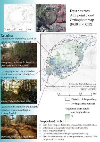
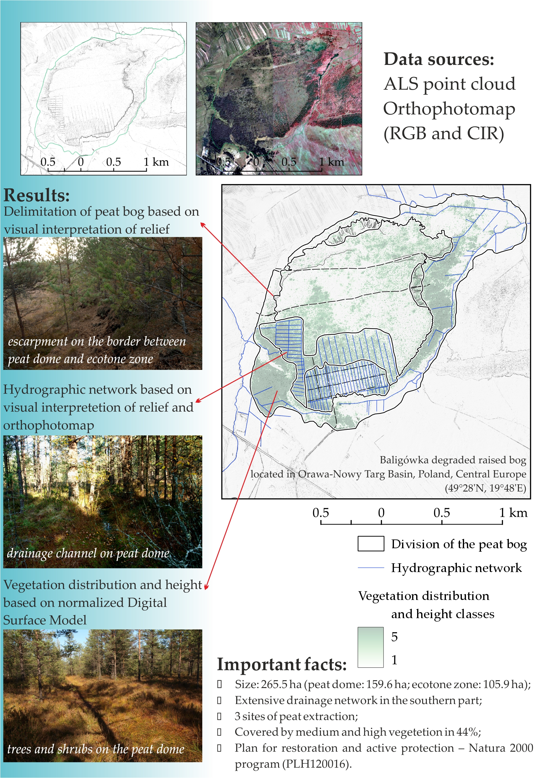
2.2. Data Sources and Processing

Two data sources were used in the article:
  • ALS data—airborne laser scanner data provided by the Polish national ISOK (pol. Informatyczny System Osłony Kraju—IT System of State Protection against natural hazards) in standard I for areas outside large cities. The density of measurement points for this standard is 4–6 points/m2. The declared accuracy of measurement is 0.2 m. Currently, the ISOK database is provided by the website of the polish state geoportal [29] as raw point clouds with classification (bare ground points, points on vegetation on a three-level height scale (low, medium, high), points on artificial surfaces, points reflected from the water surface and unclassified), divided into parts with an area of about 1 sq. km, as well as raster models (DEM) with a resolution of 1 m, and divided into parts with an area of about 4 sq. km. The source material for the research area was created in 2014.
  • Orthophotomap of Poland—prepared by the Polish Head Office of Geodesy and Cartography, also available via the geoportal website as downloadable spatial data. The orthophotomap used in the study was created on 1 August 2015 in two variants: RGB (natural colors) and CIR (color infrared). The spatial resolution of the material is 0.25 m.
The ALS data was used in the LASTools module to generate two raster models:
  • Digital elevation model (DEM) using data reflected from the ground surface,
  • Digital surface model (DSM) using data reflected from the ground surface and low, medium and high vegetation.
The spatial resolution of the models was set at 1 m, giving the best results and commonly used in studies using ALS ISOK data [30,31,32].
Digital terrain models (DTM) were derived from the DEM: shaded relief model, multi hill-shading, slopes, aspect. Then, a visual interpretation of the surface details of the bog relief was carried out, resulting in the division of the object:
  • The border of the bog was marked out along the range of agricultural land visible as a complex of plots separated by agricultural balks [28];
  • The border between the dome and the ecotone zone was drawn along the steep slope visible in the model as a narrow line with a much higher slope value (30–70 degrees) compared to the adjacent areas that are almost flat [25];
  • The ranges of industrial and artisanal peat extraction sites have been determined based on the linear depressions of the drainage system and low escarpment on the border of the industrial exploitation area. In high-resolution models showing small landforms (shaded relief model, slope model, etc.), a grid of regular linear depressions—drainage ditches is visible. In addition, the peat extraction area on the dome is about 1–2 m lower than the rest of the dome [21]. An additional subdivision of the industrial peat extraction site was determined on the basis of the differences in the intensity of extraction visible in the model—greater density of the drainage grid, between them there are linear wide depressions caused by peat extraction. The sites of ongoing artisanal peat extraction were additionally confirmed in the literature [3] and during field observations [28].
For the delimitation of medium and high vegetation overgrowing on the bog, a normalized Digital Surface Model (nDSM) was generated, calculated as a differential raster layer based on DSM and DEM [31]. It represents the height of vegetation above ground level [30,32]. In the next step, the nDSM was reclassified into five classes according to the height of vegetation [m] above the ground level: 1 (0.0–0.3), 2 (0.4–1.0), 3 (1.1–2.0), 4 (2.1–5.0), 5 (5.0<). Class 1 includes low vegetation, taking into account the range of 0.2 m error in the height measurement for the data [32]. Based on a study on the creation and update of a digital forest map [33], the boundary between class 2 and 3 at a height of 1.0 m was established. Class 3 includes shrubs and trees up to a height of 2.0 m, and therefore also dwarf mountain pine (Pinus mugo) sites occurring in the peat bogs of the Orawa-Nowy Targ Basin [23,25]. The last two classes cover high vegetation according to the classification used in the ISOK program. Class 4 includes trees up to 5.0 m high, and 5 higher than 5.0 m. For the purposes of assessing the used classification, a database of the wooded and shrubbed areas of the bog was also prepared based on the visual interpretation of the orthophotomap. It was used to assess the compliance of the range of medium and high vegetation determined by the reclassified nDSM.
A measurement and statistical description of the drainage system and the density of medium and high vegetation on parts of the bog were carried out using the zonal raster statistics and a raster buffering tool. The entire workflow is presented in Figure 3.

3. Results

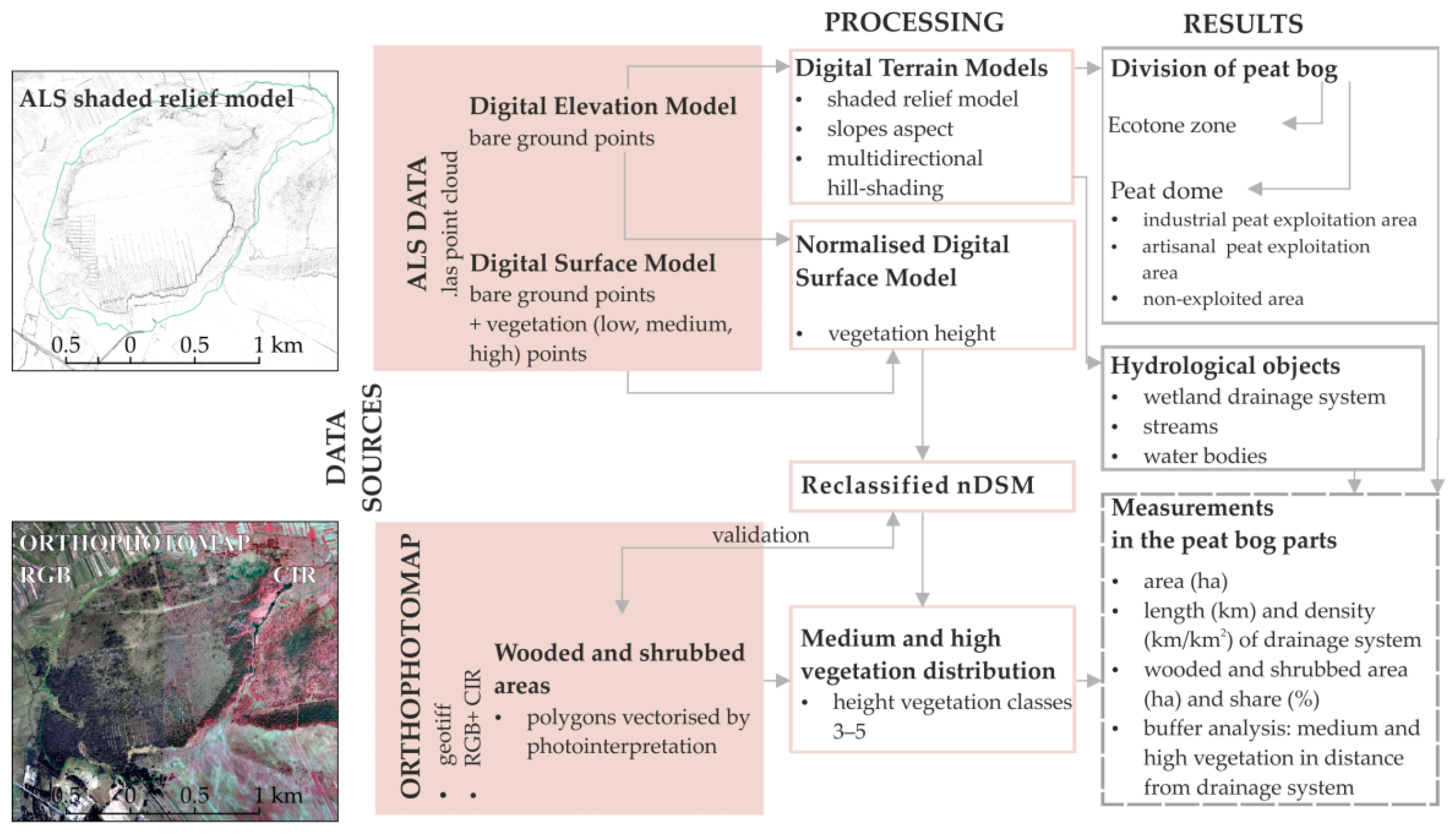
3.1. Range, Division and Drainage System of Baligówka Peat Bog

The Baligówka peat bog has a shape close to an oval SW-NE (Figure 4a). The area of the object is 265.5 ha (Table 1). The dome is surrounded by an ecotone zone which covers 40% of peat bog area (105.9 ha). The ecotone is the widest in NE and SW part, the tightest in the W part, because of gradually including to the agricultural area (Figure 4a). In some places the farmlands are directly adjacent to the peat dome.
The peat bog dome area is 159.6 ha and the perimeter is 7.04 km. At the length of 5.43 km, the border between the dome and the ecotone zone is visible in the ALS model as a steep slope with a height difference of up to 6 m (Figure 4b).
In the other places the slope is lower and less steep.There are 3 fields of peat exploitation in the peat dome: 1.1.1. large industrial peat exploitation area in the southern part; there are three parallel access roads and a dense network of drainage ditches on the part adjacent to the edge of the dome. This area is lower than the rest of the dome by 2 m, to the altitude of 655 m above sea level (Figure 4d). 1.2.1. small artisanal peat exploitation area northwest of the peat dome. 1.2.2. small artisanal peat exploitation area northeast of the peat dome.
Small areas in the northern part of the peat dome (Figure 4a, 1.2.1. and 1.2.2.) are places of artisanal peat exploitation. During the field research it was observed that peat exploitation in this place is still ongoing, or has ended recently. The signs of earlier exploitation are visible in the form of slopes located on the border between the peat dome, the east part of the ecotone zone, and in the north part of the peat dome. Two unpaved roads intersect the peat dome with the course W-E.
The hydrographic network consists of two natural watercourses—the Czarna Woda stream, which is located in the west out of range of the Baligówka peat bog, and the Piekielnik stream, which drains the east part of the ecotone zone with length 2.47 km and also has its spring there (Figure 4a). The rest are drainage ditches with a course similar to a rectilinear.
A very dense regular network of ditches is in the south part of the Baligówka peat bog. This area includes parts of peat bog which were industrially exploited and hard drained. The network’s density here reaches as much as 36.86 km/km2, but in the exploited area of the peatland there is twice as much of the drained area (Figure 4c,d). Next to that there are drainage ditches located strictly in the ecotone zone. However, they do not form a regular mesh, but surround the fen or drain the water flowing out of the dome outside the site (Figure 4a).

3.2. Assesment of Medium and High Vegetation Succession

Areas with vegetation height classes 3 to 5 (above 1.1 m high) on the nDSM were assumed to be covered with medium and high vegetation. The range determined in this way was compared with the data collected through the interpretation of the orthophotomap. The evaluation of the data indicated values from the range of classes 3 to 5 as the most consistent with the data from photointerpretation (97.224% correctness). The range of classes 2 to 5 (vegetation higher than 0.4 m) coincided with the data from the interpretation of the orthophotomap in 88.434%, and classes 4 to 5 (vegetation higher than 2.1 m) in 84.101%.
Medium and high vegetation (above 1.1 m) occupies 44% of the Baligówka peat bog. The shares in the area of the peat dome and the ecotone zone of the bog are almost identical (43.97% and 44.02%). The spatial distribution is not regular (Figure 5). There are two areas in the bog with a large share of medium and high vegetation.
The first one is located in the eastern part, along the Piekielnik stream. The western boundary runs along the steep slope between the dome of the peat bog and the ecotone zone—high vegetation in this place covers the adjacent area of the dome to a much lower extent. The second area is located in the south-western part of the peat bog. This place is directly adjacent to the exploitation field located on the dome. The ecotone zone in this place is wider than in the others. Medium and high vegetation in this place has already entered the peat dome and largely covers its southern part, both the areas of industrial peat exploitation (1.1.) as well as the adjacent part of the fen (1.3.). 61% of the entire industrial exploitation area is occupied by medium and high vegetation. Its share is particularly large in the range of the drainage network (1.1.2.), where it amounts to 79.3%. It is arranged linearly along the drainage network (Figure 5). Medium and high vegetation also covers the dome in the northern part, but it is not as dense as in the southern part. The central and western parts of the peat dome are the areas with the lowest concentration of medium and high vegetation.
The share of vegetation higher than 5.0 m is twice as high in the ecotone zone (29.36%) than in the peat dome (14.97%), located mainly within the drainage network. In the non-exploited part of the peat dome, it amounts to only 4.92%.
The entering of medium and high vegetation into the peat bog area is related spatially to the drainage network (Figure 6). The areas it occupies (Figure 6a) are negatively correlated (ρ = −0.615) with the distance to the drainage system (Figure 6b).

4. Discussion

Mapping of wetlands is one of the basic problems related to the use of remote sensing techniques in the studies on these environments [34,35,36]. Spatial resolution and data accuracy are indicated as the main obstacle in the methods of semi-automatic classification of remote sensing materials in terms of delimitation of these objects, especially inland wetlands [37,38,39]. The most accurate source materials for assessing the size of individual objects are still airborne data, especially orthophotos and their visual interpretation in many studies on single objects [35]. Airborne laser scanning (ALS) is also increasingly used in wetland research [25,39,40].
The morphology and vicinity of the bogs in the Orawa-Nowy Targ Basin (Figure 1) offers great opportunities for remote sensing inventory, especially with the use of ALS data. These bogs are reduced as a result of centuries of exploitation and are adjacent to arable fields [3]. Plot boundaries are clearly visible in the ALS data model [32]. In the case of the bogs of the Orawa-Nowy Targ Basin, they also determine the current range of the ecotone zone of these objects [13,25]. The measurements of the size of the Baligówka peat bog, its dome and ecotone zone (Table 1), are consistent with the data by other authors—Łajczak [22] estimates the size of the bog at 2.7 sq. km, and the size of the dome at 1.6 sq. km. However, the use of remote sensing and GIS data allows for a much more precise determination of the range and shape of the object, as well as its division [25]. The range of melioration and exploitation of peat in the Baligówka peat bog visible in the ALS model and delimited in this study is slightly greater than estimated by the authors of previous publications [22,23].
DTMs derived from ALS models enable the interpretation of different linear forms related to the peat bog. The models show steep slopes on the border between the dome of the peat bog and the ecotone zone, which is also located in various peat bogs of the Orawa-Nowy Targ Basin [25,28]. The models also show hydrological objects: natural and artificial watercourses. Drainage ditches are easily distinctive from natural streams by their regular, almost linear shape. They are distinguished from other linear artificial objects, such as roads or field fortifications [41], by their small width and visible connections with natural watercourses. However, the visibility of the drainage network in the model allows only a visual interpretation of its shape—in the course of ditches, there are shallows and gaps caused by model errors, which are necessary to eliminate before any hydrological modeling or analyses [42,43].
Using remote sensing data, it is impossible to determine the time of creation and functioning of the drainage network—it is necessary to use other source materials. However, the anthropogenic landforms are very durable, especially in later undeveloped areas. The industrial peat exploitation for the heating purposes in the southern part of the Baligówka peat bog lasted in the 1940s to 1950s, until peat was removed from the list of natural fuels and the extraction of peat for these purposes was made illegal under Polish law [21]. Contemporary artisanal extraction of peat in the northern part of the bog is also illegal [3,25]. The range of industrial peat exploitation is visible despite the passage of 70 years from its ending. This feature and the interpretative possibilities of high-resolution DTMs derived from ALS data are also already used in historical and archaeological research [41], especially in forested areas. As one of the few remote sensing techniques, the ALS enables precise mapping of the relief also under tree canopy [25,33,41,42].
The overgrowing of the Baligówka peat bog by medium and high vegetation is a symptom of degradation of its ecosystem—in natural conditions, the area of the bog would be too wet, unstable, as well as poor in nutrients to grow tall shrubs or trees [15,23,28]. Many research indicated that peatland drainage may have a long-term effect on the structure of the phytocoenoses in marshland habitats [44] and biophilic elements exports [45]. The problem of the disappearance of selected plant species and habitats in the raised bogs of Orawa-Nowy Targ Basin has been described many times [15,27]. Moreover, among the results of these processes, the most harmful are related to the decrease in the accumulation of organic matter and development of new non-peat-forming communities. This phenomenon may be magnified by the eutrophication of organic matter, which accumulated over thousands of years [46]. Human impact, which led to a rapid invasion of trees in open areas of raised bog and development of forest habitats are often documented in other regions in Poland [47,48,49].
The changes occurring in the bogs, both natural and induced by human activity, in many cases concern the water balance; hence, among the methods of active protection of fens, actions are taken to maintain or rebuild water conditions [50]. The acrotelm area plays an important role here, which in the case of raised bogs in southern Poland is characterized by a different degree of humidity, up to the form with periodically or constantly stagnant water [3,23,24]. This is due to the fact that raised bogs have the highest water capacity among all types of bogs. The appropriate volume of rainwater must be secured for the continued existence of the ecosystem. Moreover the most important microhabitats include high hummocks, hummocks, high ridges, lawns, carpet, Sphagnum hollows, mud-bottom hollows, drought-sensitive pools and permanent pools [51].
For several decades attempts have been made to establish institutional protection of the peat bogs of the Orawa-Nowy Targ Basin as a national or a landscape park—these are the two most important institutions of nature protection in Poland. The local community is against their creation [22,28] due to the experience of existing in the vicinity of the basin of four national parks in the the Tatra, Babia Góra, Gorce and Pieniny mountain ranges, as well as restrictions related with them in the agriculture, forestry and industrial facilities (including traditional but illegal artisanal peat extraction). Nowadays, only one of the 30 peat bogs in the Polish part of the Orawa-Nowy Targ Basin is protected by the nature reserve—“Bór na Czerwonem” near the town of Nowy Targ (Figure 1, 27). It is also one of the oldest nature reserves in Poland, established in 1925 [52].
The peat bogs of the Orawa-Nowy Targ Basin are the subject of protection in the currently planned Natura 2000 area with the ID PLH120016 [22]. The protection plan for the site was approved in 2019 [53]. The Baligówka peat bog is intended for restoration activities under the protection plan, including the installation of gates on the functioning drainage ditches of the peat dome in order to block the outflow of water, cutting out trees on the dome and the renewing of peat-forming vegetation cover. As for 2022, the area has not been established yet. Activities of this type are associated with large financial costs and the difficult task of convincing local residents to the benefits of maintaining these ecosystems. An important task in the future is also to describe the experience and effectiveness of active protection of the peat bogs in the Orawa-Nowy Targ Basin as well as other wetlands, which has been rarely published so far [46,54].

5. Conclusions

The area of the Baligówka peat bog was determined at 2.65 sq. km. It was also possible to determine the extent of melioration and peat exploitation, both industrial and artisanal, on the basis of a visual interpretation of the high-resolution ALS terrain model. The drainage system created during industrial exploitation is very dense (36.86 km/sq. km) and still affects the hydrological conditions of the object, resulting in entering a non-peat bog medium, and high vegetation on the dome. The research raised bog is increasingly less covered by open mossy phytocoenosis.
Creating a database of vegetation coverage with the ALS derived nDSM shows a high correctness with the reference method of obtaining this spatial information using the orthophotomap interpretation (97.224%), with incomparably less handwork involvement. Currently, medium and high vegetation covers 44% of the Baligówka peat bog. Its share will increase (peat bog plants will disappear in favor of shrubs and trees), unless the hydrological conditions change—the range of medium and high vegetation is spatially correlated with the extent of the drainage system.
The results presented in this study prove the need to immediately take protective action to improve the condition of the Baligówka raised bog. The planned restoration of the Baligówka peat bog may cause a significant changes in the water conditions and qualitative and quantitative changes in the vegetetion cover present there. Further multidisciplinary research will be needed. The raised bogs are labile ecosystems, the development of which are strongly dependent on climatic and water conditions as well as human activity. Previous observations in other degraded peat bogs confirm that a certain depth of peat was required to stabilize the water level. In a study site, active management, such as removing invasive trees and the main ditches appears to be necessary. These activities will significantly reduce discharged water during the spring and summer floods.

Author Contributions

Conceptulization, introduction, study area are written by W.J., P.M. and D.O. W.J.: project management, spatial data curation, writing text about plants of the Baligówka raised bog. P.M.: visualization to methodology and writing text about division of the Baligówka raised bog. W.J. and D.O.: writing original draft, review and editing. All authors have read and agreed to the published version of the manuscript.

Funding

This research received no external funding.

Data Availability Statement

Not applicable.

Conflicts of Interest

The authors declare no conflict of interest.

References

  1. Savenije, H.H.G.; Hoekstra, A.Y.; van der Zaag, P. Evolving water science in the Anthropocene. Hydrol. Earth Syst. Sci. 2014, 18, 319–332. [Google Scholar] [CrossRef] [Green Version]
  2. Lipka, K. Peat cover and water resources of peat deposits in the upper Warta basin. Infrastruct. Ecol. Rural Areas 2008, 5, 63–70. [Google Scholar]
  3. Łajczak, A. Reduction of the extent of peat deposits and their water retention capacity in the Orawa-Nowy Targ Basin and Bieszczady Mts. due to human activity. Prz. Geol. 2013, 61, 532–540. [Google Scholar]
  4. Zając, E.; Lipka, K. Wielofunkcyjność torfowisk w środowisku przyrodniczym. Aura 2005, 4, 7–8. [Google Scholar]
  5. Tobolski, K. Issues of peat bogs in forest areas. Stud. I Mater. CEPL 2007, 9, 541–549. [Google Scholar]
  6. Minayeva, T.Y.; Bragg, O.M.; Sirin, A.A. Towards ecosystem-based restoration of peatland biodiversity. Mires Peat 2016, 16, 1–36. [Google Scholar] [CrossRef]
  7. Słowiński, M.; Lamentowicz, M.; Łuców, D.; Barabach, J.; Brykała, D.; Tyszkowski, S.; Pieńczewska, A.; Śnieszko, Z.; Dietze, E.; Jażdżewski, D.; et al. Palaeoceological and historical data as an important tool in ecosystem management. J. Environ. Manag. 2019, 236, 755–768. [Google Scholar] [CrossRef]
  8. Marcisz, K.; Czerwiński, S.; Lamentowicz, M.; Łuców, D.; Słowiński, M. How palaeoceology can suport peatland restoration. Pages Mag. 2022, 30, 12–13. [Google Scholar] [CrossRef]
  9. Grzybowski, M.; Glińska-Lewczuk, K. The principal threats to the peatland habitats, in the continental bioregion of Central Europe—A case study of peatland conservation in Poland. J. Nat. Conserv. 2020, 53, 12778. [Google Scholar] [CrossRef]
  10. Pleskot, K.; Apolinarska, K.; Cwynar, L.C.; Kotrys, B.; Lamentowicz, M. The late-Holocene relationship between peatland watertable depth and summer temperature in northern Poland. Palaeogeogr. Palaeoclimatol. Palaeoecol. 2022, 586, 110758. [Google Scholar] [CrossRef]
  11. Łyszczarz, R.; Suś, R. The dynamics of ground waters and hydrogenic soil subsidence in the Bydgoszcz Canal Valley. Water-Environ. Rural Areas 2009, 9, 163–175. [Google Scholar]
  12. Fiałkiewicz-Kozieł, B.; Smieja-Król, B.; Palowski, B. Heavy metal accumulation in two peat bogs from southern Poland. Studia Quat. 2011, 28, 17–24. [Google Scholar]
  13. Pawełczyk, F.; Bloom, K.; Jucha, W.; Michczyński, A.; Okupny, D.; Sikorski, J.; Tomkowiak, J.; Zając, E.; Fagel, N. Reconstruction of atmospheric lead and heavy metal pollution in the Otrębowskie Brzegi peatland (S Poland). Geol. Quarterly 2019, 63, 568–585. [Google Scholar] [CrossRef] [Green Version]
  14. Warburton, J. Peat landslides. Landslide hazards, Risks, and Disaster. Hazards Disaster Ser. 2015, 6, 159–190. [Google Scholar] [CrossRef]
  15. Malec, M.; Klatka, S.; Ryczek, M. Wpływ antropopresji na dynamikę wzrostu warstwy akrotelmowej na torfowisku wysokim Baligówka w Kotlinie Orawsko-Nowotarskiej. Acta Sci. Pol. Form. Circumiectus 2015, 14, 149–160. [Google Scholar] [CrossRef]
  16. Zając, E.; Zarzycki, J.; Ryczek, M. Substrate quality and spontaneous revegetation of extracted peatland: Case study of an abandoned Polish mountain bog. Mires Peat 2018, 12, 14. [Google Scholar] [CrossRef]
  17. Tannenberger, F.; Tegetmayer, C.; Busse, S.; Barthelmes, A.; Shumka, S.; Mariné, A.M.; Jenderedjian, K.; Steiner, G.M.; Essl, F.; Etzold, J.; et al. The peatland map of Europe. Mires Peat 2017, 19, 22. [Google Scholar] [CrossRef]
  18. Żurek, S. The peat deposits of Poland against the peat zones of Europe. Dok. Geogr. IGiPZ PAN 1987, 4, 84. [Google Scholar]
  19. Lipka, K.; Kosiński, K. Torfowiska w okolicy Czarnego Dunajca na tle sieci hydrograficznej. In Sesja Naukowa “Melioracje Terenów Górskich a Ochrona Środowiska”; Akademia Rolnicza: Kraków, Poland, 1993; pp. 197–209. [Google Scholar]
  20. Referowska-Chodak, E. The role of nature reserves in the protection of forest wetlands. Stud. I Mater. CEPL 2017, 51, 195–205. [Google Scholar]
  21. Łajczak, A. Historyczne formy użytkowania torfowisk Orawsko-Nowotarskich i zmiana ich powierzchni w XIX i XX w. Probl. Zagospod. Ziem Górskich 2001, 47, 55–73. [Google Scholar]
  22. Łajczak, A. Natura 2000 in Poland, Area PLH120016 the Orawsko-Podhalańskie Peatlands; W. Szafer Institute of Botany, Polish Academy of Sciences: Kraków, Poland, 2007; p. 139. [Google Scholar]
  23. Malec, M.; Ryczek, M.; Klatka, S.; Kruk, E. Przebieg procesu torfotwórczego na zdegradowanym torfowisku Baligówka. Acta Sci. Pol. Form. Circumiectus 2016, 15, 91–100. [Google Scholar] [CrossRef]
  24. Koczur, A. Influence of peat exploitation on vegetation on the Puścizna Wielka peat bog in the Orawsko-Nowotarska Basin (Western Carpathians, S Poland). Chrońmy Przyr. Ojczystą 2008, 64, 25–44. [Google Scholar]
  25. Jucha, W.; Mareczka, P.; Okupny, D. Using remote sensing materials to assess the effets of peat extraction on the morphology and vegetation cover of a raised bog (Ludźmierz near Nowy Targ, Southern Poland). Mires Peat 2020, 26, 28. [Google Scholar] [CrossRef]
  26. Mayner, K.M.; Moore, P.; Wilkinson, S.L.; Petrone, R.; Waddington, J.M. Delineating boreal plains bog margin ecotones across hydrogeological settings for wildfire risk management. Wetl. Ecol. Manag. 2018, 26, 1037–1046. [Google Scholar] [CrossRef]
  27. Koczur, A. Importance of vegetation in the Orawsko-Nowotarskie Peat Bogs to biological diversity in the Polish Carpathians. Acta Agrophys. 2006, 7, 383–393. [Google Scholar]
  28. Jucha, W.; Karaś, J.; Mareczka, P.; Okupny, D. Mokradła i torfowiska jako temat zajęć terenowych w edukacji geograficznej. Ann. Univ. Paedagog. Crac. Stud. Geogr. 2020, 14, 203–221. [Google Scholar] [CrossRef]
  29. Główny Urząd Geodezji i Kartografii—Geoportal Infrastruktury Informacji Przestrzennej. Available online: http://www.geoportal.gov.pl/ (accessed on 30 April 2022).
  30. Szostak, M.; Wężyk, P.; Tompalski, P. Aerial orthophoto and airborne laser scanning as monitoring tools for land cover dynamics: A case study from the Milicz Forest District (Poland). Pure Appl. Geophys. 2014, 171, 857–866. [Google Scholar] [CrossRef] [Green Version]
  31. Kolecka, N. Height of successional vegetation indices moment of agricultural land abandonment. Remote Sens. 2018, 10, 1568. [Google Scholar] [CrossRef] [Green Version]
  32. Czesak, B.; Różycka-Czas, R.; Salata, T.; Dixon-Gough, R.; Hernik, J. Determining the intangible: Detecting land abandonment at local scale. Remote Sens. 2021, 13, 1166. [Google Scholar] [CrossRef]
  33. Wężyk, P.; Szostak, M.; Tompalski, P. Use of airborne laser scanning data for a revision and update of a Digital Forest Map and its descriptive database: A case study from the Tatra National Park. In The Carpathians: Integrating Nature and Society towards Sustainability, Environmental Science and Engineering; Kozak, J., Ostapowicz, K., Bytnerowicz, A., Wyżga, B., Eds.; Springer: Berlin/Heidelberg, Germany, 2013; pp. 615–627. [Google Scholar] [CrossRef]
  34. Ozesmi, S.L.; Bauer, M.E. Satellite remote sensing of wetlands. Wetl. Ecol. Manag. 2002, 10, 381–402. [Google Scholar] [CrossRef]
  35. Chasmer, L.; Kahoney, C.; Millard, K.; Nelson, K.; Peters, D.; Merchand, M.; Hopkinson, C.; Brisco, B.; Niemann, O.; Montgomery, J.; et al. Remote sensing of boreal wetlands 2: Methods for evaluating boreal wetland ecosystem state and drivers of change. Remote Sens. 2020, 12, 1231. [Google Scholar] [CrossRef] [Green Version]
  36. Czapiewski, S.; Szumińska, D. An overview of remote sensing data applications in peatland research based on works from the period 2010-2021. Land 2022, 11, 24. [Google Scholar] [CrossRef]
  37. Lamentowicz, M. Identification of natural peatlands in example of Tuchola Forest inspectorate. Stud. I Mater. CEPL 2007, 9, 571–583. [Google Scholar]
  38. Dronova, I. Object-based image analysis in wetland research: A review. Remote Sens. 2015, 7, 6380–6413. [Google Scholar] [CrossRef] [Green Version]
  39. Carless, D.; Luscombe, D.J.; Gatis, N.; Anderson, K.; Brazier, R.E. Mapping landscape-scale peatland degradation using airborne lidar and multispectral data. Landsc. Ecol. 2019, 34, 1329–1345. [Google Scholar] [CrossRef] [Green Version]
  40. Zlinszky, A.; Mücke, W.; Lehner, H.; Briese, C.H.; Pfeifer, N. Categorizing wetland vegetation by airborne laser scanning on Lake Balaton and Kis-Balaton, Hungary. Remote Sens. 2012, 4, 1617–1650. [Google Scholar] [CrossRef] [Green Version]
  41. Jucha, W.; Franczak, P.; Sadowski, P. Detection of World War II field fortifications using ALS and archival aerial images—German OKH Stellung b1 trenches in the south of the Polish Carpathians. Archaeol. Prospect. 2021, 28, 35–45. [Google Scholar] [CrossRef]
  42. Bryndal, T.; Kroczak, R. Reconstruction and characterization of the surface drainage system functioning during extreme rainfall: The analysis with use of the ALS LiDAR data—The case study in two small flysch catchments (Outer Carpathian, Poland). Environ. Earth Sci. 2019, 78, 215. [Google Scholar] [CrossRef] [Green Version]
  43. Kroczak, R.; Bryndal, T.; Żychowski, J. Surface drainage systems operating during heavy rainfall—A comparative analysis between two small flysch catchments located in different physiographic regions of the Western Carpathians (Poland). Water 2022, 14, 482. [Google Scholar] [CrossRef]
  44. Czerepko, J. A long-term study of successional dynamics in the forest wetlands. For. Ecol. Manag. 2008, 255, 630–642. [Google Scholar] [CrossRef]
  45. Nieminen, M.; Sarkkola, S.; Sallantaus, T.; Hasselquis, A.M.; Laudon, H. Peatland drainage—A missing link behind increasing TOC concentrations in waters from high latitude forest catchments? Sci. Total Environ. 2021, 774, 145150. [Google Scholar] [CrossRef] [PubMed]
  46. Schubert, T. Removing trees and shrubs form mires—A method of an active mire conservation. Stud. Limnol. Telmatol. 2010, 4, 75–84. [Google Scholar]
  47. Kochanowska, R.; Prajs, B.; Prajs, J. Floristic studies of the Reptowo peatland. Water-Environ. Rural Areas 2001, 1, 221–232. [Google Scholar]
  48. Kucharski, L.; Kurzac, M.; Rakowska, B.; Sitkowska, M. Changes in the flora and vegetation of the Torfowisko Rąbień near Łódź (Poland), and their proposed conservation methods. Nat. Conserv. 2004, 60, 49–62. [Google Scholar]
  49. Sotek, Z.; Stasińska, M.; Malinowski, R.; Gamrat, R.; Gałczyńska, M. Birch Bog on anthropogenically transformed raised bogs. A case study from Pomerania (Poland). Water 2019, 11, 1224. [Google Scholar] [CrossRef] [Green Version]
  50. Jasnowski, M. Aktualny stan i program ochrony torfowisk w Polsce. Chrońmy Przyr. Ojczystą 1977, 33, 18–29. [Google Scholar]
  51. Tobolski, K. Biogenic accumulation environments in lakes and peatlands. In Deposits of the Biogenic Accumulation Reservoirs; Miotk-Szpiganowicz, G., Tobolski, K., Zachowicz, J., Eds.; Polish Geological Institute: Gdańsk, Poland, 2005; pp. 34–42. [Google Scholar]
  52. Przybyła, K. Bór na Czerwonem—90 years of active protection. Successes and failures. Stud. I Mater. CEPL 2017, 51, 230–238. [Google Scholar]
  53. Zarządzenie Regionalnego Dyrektora Ochrony Środowiska w Krakowie z dn. 22.02.2019 w Sprawie Ustanowienia Planu Zadań Ochronnych dla Obszaru Natura 2000 Torfowiska Orawsko-Nowotarskie PLH120016. Dz. Urz. Województwa Małopolskiego, Kraków. 2019; p. 1617. Available online: http://edziennik.malopolska.uw.gov.pl/WDU_K/2019/1617/akt.pdf (accessed on 30 April 2022).
  54. Jędryka, E. Technical potentials of affecting River Valley with the wetland habitats in order to restitute them. Water Environ. Rural Areas 2001, 1, 197–210. [Google Scholar]
Figure 1. Location of study area: (a) localization of maps (b,c); (b) map of peat bogs in the Orawa-Nowy Targ Basin; (c) 3D model of the central part of the Polish Carpathian Mountains with location of the peat bogs.
Remotesensing 14 02817 g001
Figure 2. Map of the Baligówka peat bog.
Remotesensing 14 02817 g002
Figure 3. Scheme of workflow in the study.
Remotesensing 14 02817 g003
Figure 4. (a) Division of the Baligówka peat bog; (b) topographic profile along non-exploited part of the peat dome; (c) topographic profile along drainage system area; (d) topographic profile along industrial peat exploitation area.
Remotesensing 14 02817 g004
Figure 5. Distribution of vegetation height classes in the Baligówka peat bog.
Remotesensing 14 02817 g005
Figure 6. (c) Relationship between the spatial distribution of medium and high vegetation areas (a) and distance to drainage system (b).
Remotesensing 14 02817 g006
Table 1. The results of the measurement of the area and drainage system of the Baligówka peat bog. Numbers as in Figure 4.
SectionArea
(ha)
Drainage System
Length
(km)
Density
(km/sq. km)
Total peat bog area265.528.1210.59
  • Peat dome, including:
159.618.9136.86
1.1.
Industrial peat exploitation + drainage system area:
1.1.1.
Industrial peat exploitation area
1.1.2.
Range of drainage system
1.2.
Artisanal peat exploitation area:
1.2.1.
North-west part
1.2.2.
North-east part
1.3.
Non-exploited part of peat dome
51.318.9111.85
19.711.0255.81
31.67.8924.99
7.30n/a
4.40n/a
2.90n/a
101.00n/a
2.
Ecotone zone
105.99.218.69
Publisher’s Note: MDPI stays neutral with regard to jurisdictional claims in published maps and institutional affiliations.

