Review

Unmanned Aerial Vehicles for Search and Rescue: A Survey

1
Department of Aeronautical and Aviation Engineering, The Hong Kong Polytechnic University, Hong Kong 999077, China
2
Department of Automation, Harbin Institute of Technology, Shenzhen 518055, China
3
Department of Industrial and Systems Engineering, The Hong Kong Polytechnic University, Hong Kong 999077, China
4
Research Institute for Sports Science and Technology, The Hong Kong Polytechnic University, Hong Kong 999077, China
*
Author to whom correspondence should be addressed.
Remote Sens. 2023, 15(13), 3266; https://doi.org/10.3390/rs15133266
Submission received: 9 May 2023 / Revised: 3 June 2023 / Accepted: 19 June 2023 / Published: 25 June 2023

Abstract

:
In recent years, unmanned aerial vehicles (UAVs) have gained popularity due to their flexibility, mobility, and accessibility in various fields, including search and rescue (SAR) operations. The use of UAVs in SAR can greatly enhance the task success rates in reaching inaccessible or dangerous areas, performing challenging operations, and providing real-time monitoring and modeling of the situation. This article aims to help readers understand the latest progress and trends in this field by synthesizing and organizing papers related to UAV search and rescue. An introduction to the various types and components of UAVs and their importance in SAR operations is settled first. Additionally, we present a comprehensive review of sensor integrations in UAVs for SAR operations, highlighting their roles in target perception, localization, and identification. Furthermore, we elaborate on the various applications of UAVs in SAR, including on-site monitoring and modeling, perception and localization of targets, and SAR operations such as task assignment, path planning, and collision avoidance. We compare different approaches and methodologies used in different studies, assess the strengths and weaknesses of various approaches, and provide insights on addressing the research questions relating to specific UAV operations in SAR. Overall, this article presents a comprehensive overview of the significant role of UAVs in SAR operations. It emphasizes the vital contributions of drones in enhancing mission success rates, augmenting situational awareness, and facilitating efficient and effective SAR activities. Additionally, the article discusses potential avenues for enhancing the performance of UAVs in SAR.

1. Introduction

The development of unmanned aerial vehicles (UAVs), also known as drones, has led to a significant improvement in the efficiency of search and rescue (SAR) operations. The successful implementation of drones in numerous disaster relief efforts has demonstrated their effectiveness in performing tasks that were previously difficult or impossible for humans to accomplish. The primary goal of search and rescue missions is to locate the target as quickly as possible and take necessary follow-up actions, such as the exchange of information and delivery of supplies, within a limited timeframe. The use of drones for SAR operations has several advantages, including their ease of deployment, low maintenance cost, high mobility, and ability to hover in areas where the use of manpower may be dangerous, limited, or require quick decisions.
Traditional data analysis methods often require manual supervision, which may limit the real-time processing and efficient utilization of data collected by unmanned aerial vehicles (UAVs). With the continuous advancement of UAV technology, including automated flight, high-precision sensors, and machine learning algorithms, large amounts of data, such as images, videos, sounds, etc., can be collected by UAVs within a short timeframe [1]. These data have tremendous potential in assisting search personnel in locating victims or assessing disaster situations more quickly in search and rescue (SAR) tasks. An assisting unmanned aerial system facilitated a rescue operation in the Bieszczady Mountains in Poland [2]. The rescue team used convolutional neural networks to automatically locate individuals in aerial images, processing a total of 782 images. After 4 h and 31 min of analysis, the system successfully detected the missing person and provided the coordinates.
The full utilization of UAV data could be greatly facilitated by the development of unsupervised data analysis methods. Automation algorithms and machine learning techniques can enhance the autonomy of UAVs, enabling them to automatically identify and calibrate targets, perform target classification and tracking, and even make real-time decisions and take action. Through the application of such unsupervised data analysis methods, the reliance on manual supervision and intervention can be reduced, leading to lower risks of human errors and subjective judgments, while improving the objectivity and consistency of data analysis. This is particularly crucial in tasks such as SAR that demand high levels of timeliness and accuracy.
For example, monitoring glacier instability is crucial for mitigating disaster risks. Unstable glaciers can trigger ice and snow avalanches that pose threats to human settlements, infrastructure, and tourist areas downstream. Unmanned aerial vehicles (UAVs), as utilized in the literature [3], are employed to capture digital terrain models (DTMs) of glaciers. DTMs are three-dimensional models that depict the surface topography, aiding in understanding glacier structure and evolution. Through techniques such as structured light scanning and LiDAR, UAVs can generate high-resolution DTMs and construct three-dimensional models on computers to depict glacier terrain features. When combined with high-frequency monitoring systems, the DTM information obtained from UAVs can be employed to monitor glacier activity and instability, providing critical data support for early warning and effective disaster management of glaciers.
The deployment of drones in SAR operations has several benefits. The ease of deployment of drones could contribute to their quick dispatch in disaster zones, where time is of the essence. Their low maintenance cost compared to manned aircraft and vehicles makes them an affordable and practical option for SAR operations. Furthermore, the high mobility of drones allows them to easily maneuver around obstacles and reach areas that may be inaccessible to humans. Lastly, drones’ ability to hover in place provides a stable platform for collecting data and imagery, which is crucial in SAR operations.
In addition to the advantages mentioned above, drones can also be equipped with various sensors and payloads to enhance their SAR capabilities. These sensors can detect signals that are difficult to detect visually, such as heat, sound, and electromagnetic radiation, and the drones can deliver supplies such as first aid kits, water, and food directly to the target site. Consequently, the use of drones in SAR operations can significantly decrease the time required to locate and aid individuals in need of assistance.
Limitations in the application of drones in search and rescue operations are also inevitable. Drones are powered by batteries, which have limited capacity and can only sustain a certain amount of flight time. A more effective payload will lead to larger power consumption, which may reduce the flight time. Apart from this, adverse weather conditions such as strong winds, heavy rain, or extreme temperatures can also affect the flight performance and stability of drones. In addition, aviation regulations impose certain limitations on drones, including restrictions on flight altitude, airspace, and operating conditions. For example, drones are typically not allowed to fly beyond the visual line of sight of the operator or in certain restricted airspace, which can limit their range and coverage area. Compliance with these regulations is crucial to ensure safe and legal drone operations, but it can also pose challenges in search and rescue scenarios where drones may need to operate in remote or restricted areas.
The primary objective of this article is to provide readers with innovative solutions and inspiration for problem-solving in the field of drone-based search and rescue. We thoroughly explore various scenarios, including the application of drones in avalanche search and rescue [4,5,6], as well as marine search and rescue operations [7,8,9], highlighting their potential as powerful tools in critical situations. Additionally, we address specific challenges encountered in drone-based search and rescue, such as path planning and obstacle avoidance. We discuss a range of representative algorithms, encompassing traditional and cutting-edge techniques, that have been developed to tackle these challenges, along with their derivatives and variations.
We aim to promote these representative algorithms and their applications in SAR scenarios, offering readers valuable insights and inspiration for their own problem-solving endeavors. Through this, we strive to encourage further research and innovation in the field of drone-based search and rescue, with the ultimate goal of enhancing the effectiveness and efficiency of operations, saving lives, and making a positive impact on society. Most of the present reviews focus on the SAR operation under a single specific circumstance (e.g., marine [7]) or the specific operation (e.g., path planning [10]). Based on our extensive study of influential academic works, we conducted a comprehensive review that initially classified UAVs based on their respective roles, thereby determining the most suitable role distribution for different types of UAVs. Instead of focusing solely on specific operations or limited environments, we expanded our scope to encompass a broader range of applications. We introduced state-of-the-art techniques, along with their derivatives and improvements, in order to provide a fundamental overview of the current advancements and offer insights into potential future directions for ongoing research.
The remaining parts of this paper are structured as follows: Section 2 introduces the classification of UAVs and some components thereof. Section 3 reviews the development and pros and cons of various applications and algorithms of UAVs in SAR to clarify the current situation and grasp the future direction.

2. Classification and Design of UAVs for SAR Operations

Unmanned aerial vehicles used for search and rescue missions are required to meet specific criteria. To fly in various complex environments and withstand different weather conditions and risks, UAVs must have a certain level of aviation capability and stability. To locate targets quickly and assist mobility, UAVs must possess high-precision positioning and navigation capabilities. Drones could be equipped with various sensors to detect the location, condition, and environmental conditions of targets. These sensors include thermal imaging sensors, infrared sensors, optical sensors, sonar, and others. High load capacity and long endurance are also required to carry necessary equipment and supplies with the sustained flight duration to meet the demands of SAR operations. This section generally introduces the unmanned aerial vehicle classification and specification. Some designs addressing the specific problems are introduced in the second subsection.

2.1. Classification of UAVs

According to the difference in structure design, the classification of UAVs could be divided into different categories [10]. Among all the classifications, corresponding advantages and deficiencies are stated. In the most general way, the UAV could be distinguished as a fixed-wing UAV, multirotor UAV, and unmanned helicopter. The integration of the propeller design and fixed-wing design leads to the hybrid UAV type, which could be specified as an independent classification and could provide aerodynamic advantages (i.e., the fixed wing is integrated with the multi-rotor UAV, providing flight efficiency while granting the ability to perform vertical take-off and landing). For different mission requirements, the most appropriate type can be selected according to the characteristics of different UAV designs.

2.1.1. Unmanned Helicopter

The unmanned helicopter has a motor on the top (main motor) of the fuselage with a large propeller to generate lift and achieve all the movements (i.e., pitch yaw and roll), while also having another motor on the tail with a small propeller to balance the torque generated by the main motor [11]. Figure 1 presents the schematic diagram of a typical type of unmanned helicopter.
The paper [13] illustrates the design of the helicopter and control systems, including minimizing the control consumption and satisfying the corresponding constraints in operating the helicopter. The advantage of the helicopter is its agility. The unique and delicate structure design enables the unmanned helicopter to change its pose swiftly and achieve much agile movement. It is suitable for fast operation in a complex environment. However, the disadvantage is the complexity of its main rotor structure; it requires multiple steering gears to achieve the movement of the helicopter. This complexity further leads to a high cost of maintenance.
Due to their hovering capability and flexible maneuverability, unmanned helicopters are well-suited for surveillance and tracking missions such as surveillance of borders, traffic flow monitoring, search and rescue operations, etc.

2.1.2. Multirotor UAV

Multirotor UAV is the most commonly seen UAV classification. It utilizes the motors and propellers to generate lift through their high-speed rotation. It could be further divided according to the number of motors, including the most common types: octocopter (eight rotors and propellers), hexacopter (six rotors and propellers), quadcopter (four rotors and propellers), and tricopter (three rotors and propellers).
As Figure 2 presents, Quadcopter X is used as an example to generally illustrate flight mechanics. Four rotors are installed at the same distance to the gravity center. To balance the torque generated from the motor rotation, the motors on the same diagonal should remain in the same rotating direction, while the rotation direction of the motors on the same side should be different. According to the paper [14], differential thrust controls the pitch, roll, and yaw movements of the quadcopter. When facing the positive direction of Quadcopter X, the pitch and roll movements are controlled by the differential thrust between front–behind pairs of rotors and left–right pairs of rotors, separately. The yaw movement is controlled by the differential thrust between diagonal pairs of rotors, generating horizontal torque clockwise or counterclockwise.
Simplicity in structure is one of the advantages of multirotor UAVs. A few rotors with propellers and electronic speed controllers (ESC) compose the basic flying frame. To improve flight performance, the multirotor UAV achieves agility moving in a smaller region. The vertical take-off and landing (VTOL) promise normal operation under both outdoor and indoor environments, which is also the reason that it is commonly used in the research area [15]. Poor endurance is one of the cons. The electricity consumption rate is high, as multiple rotors are driven to lift the aircraft, and the increase in frame weight also raises the consumption rate. With a full battery of 2600 mAh, the endurance of the quadcopter, which weighs 700 g, could only reach about 15–17 min according to our daily experiment. Thus, conflicts exist between the payload and endurance; a heavier battery means higher endurance, but also means a reduced payload that it could bear under specific endurance.
The Quadcopter UAV has good maneuverability and quick response. It is suitable for fast movement and exploration tasks. For example, it could be used for shooting sports games, quickly surveying target areas, etc.

2.1.3. Fixed-Wing UAV

Most fixed-wing UAVs (as Figure 3 shows) have a similar dynamic mechanism as commercial airplanes, such as the Boeing-747. They utilize the pressure difference between the upper surface and lower surface to generate lift. To achieve this, propulsion is generated (the thrust point is most commonly located in the tail of the fuselage). Pitch, roll, and yaw movements are achieved by the operation of elevators, ailerons, and rudders, respectively. The paper [16] illustrates the design perspectives of fixed-wing UAVs and analyzes the flight performance, including the design of the fuselage, propeller, airfoil, and winglet. The corresponding aerodynamic performance and stability are also described using computational fluid dynamics (CFD).
Surveillance and large-scale target search are the main tasks assigned to fixed-wing UAVs under search and rescue conditions [18]. This could be illustrated in the aspect of energy consumption. Quadrotors require continuous energy consumption to maintain a certain altitude while fixed-wing UAVs only briefly increase power during altitude climb. The experimental results from the literature [19] precisely confirm this point. Fixed-wing UAVs perform better in terms of energy efficiency, but their operational limitation is high-speed flight. They require higher speeds to generate sufficient lift, which also expands their required activity range. Agile movements at high speeds may result in a stall and significant stress on the UAV.

2.1.4. Hybrid UAV

Combining the advantages of the multirotor UAV and fixed-wing UAV, the hybrid UAV could achieve VTOL function and operate long-range maneuvers [20]. However, the installation of multiple sets of motors and propellers (as Figure 4 shows) may introduce more wind resistance and weight during the operation, while the complexity of the control system design is also a challenge.
Due to its design characteristic, it is suitable for use as a communication relay station. It can take off and land vertically when needed and provide communication relay support, provide wireless network connectivity to remote areas, or support disaster relief communications. The advantages and limitations of all the mentioned UAV classifications are summarized in Table 1.

2.2. Types of Design for Various Situations

Many projects aim at innovative designs that address specific problems. Particular environments (e.g., coastline patrol or indoor environments with multiple obstacles inside) and specific challenges of the corresponding applications (e.g., communication relays in out-of-service areas) have been explored.

2.2.1. UAV System Design

For UAV systems for SAR operations, many papers present and discuss different system structure designs and solutions for utilizing UAVs in SAR scenarios, including dynamic systems, communication structures, autonomy, performance evaluation, and challenges in path planning and obstacle avoidance.
A UAV system is designed for SAR competition in [22], in which take-off, landing, control, video processing, and packet-dropping task are performed. The advantage of the project is its achieving avionic performance with a low-cost structure design, but the wireless link and communication are restricted, due to which the performance of the graph processing declined. Compared to this, a fully autonomous UAV solution is proposed in [23] for assisting SAR under natural disasters, under which the SAR functions of UAVs are discussed, including autonomous path planning, environment perception, and identification of victim groups.
The paper [24] introduced a modular architecture automatic multi-UAV system with distributed communication structure for SAR. The schematic of module collaboration in the system, including planning, plan execution, UAV control, WIFI control, and streaming configurations, is illustrated. Agents provide video streams to multiple base stations through the wireless link. However, the specific scenarios and requirements for using centralized and distributed decision-making are vague. Therefore, it is inspiring for the works developing the solution to specific environments, such as deep mountains and forests, urban areas, or at sea. In [25], the performance of UAV-assisted intelligent edge computing is evaluated and the parameter optimization is proposed for enhancing the UAV network computing ability and UAV team SAR efficiency. The evaluated path loss is used as a threshold reference for triggering the intelligent edge computation, but the massive computation of path planning and obstacle avoidance is a major challenge to UAV-assisted intelligent edge computing.
For hardware design, some innovative designs are also being researched for promoting the mobility of drones. In [26], a propeller is designed for high-altitude SAR operation of UAVs. The result of CFD further proves the effectiveness and integrity of the blade. To improve the mobility of multirotor UAVs, the paper [27] introduced tiltable rotors into quadrotor design, developing three types of new movements for quadrotors such as vector-flying, tilting, hovering, and driving. This leads to better mobility in operating SAR tasks, and more adaptive movement could be performed in complex environments.

2.2.2. Communication and Deployment

UAV-to-UAV communication plays a critical role in improving the efficiency and adaptability of UAV swarms. It enables the coordination of tasks, the transmission of status information, sharing of sensor data, and collaborative localization among UAVs. UAV swarms can also act as a network of base stations to provide communication services in areas with poor or no wireless network infrastructure. These UAV-swarm base stations can enhance the performance of the network by providing flexibility and adaptability.
In the paper [28], UAV teams are utilized for constructing wireless communication networks in connection-disabled areas. This paper discusses the basic networking architecture, including control and non-payload communication links and data links, and channel characteristics, including the UAV–ground channel and UAV–UAV channel. To enhance the UAV network performance, the design consideration is proposed including UAV deployment, energy-aware operation, and device-to-device communication for enhancing the UAV information propagation. However, the detailed communication strategy is elaborated by assumption, such as the ignorance of Doppler effect compensation between each relay node. The paper [29] also researched the optimized deployment of UAVs as base stations. The proposed strategy utilizes the facility location framework [30] to determine the location of the UAV base station and minimize the total transmit power. The optimized UAV location is determined by user distribution, but the acquisition of user locations and optimization of distribution should be further illustrated.
The paper [31] studied the three-dimensional deployment of UAV base stations (UAVBS) for maximum user coverage with different quality of service, given the restricted transmitting power and quality requirement for services. To enhance the quality of services, the paper [32] proposed a model for a UAV base station providing services to randomly distributed users. Exhaustive search and particle swarm optimization is used for optimizing the efficiency, which is determined as maximizing the served users with maximum service quality. The proposed model increases served users by about 17%, but the charging strategy of the UAV base station should be further discussed to enhance the duration of the system. The paper [33] introduced a framework for multi-UAV teams to search for targets that stochastically appear in continuous space with random elements. The implementation in garden cleaning was used as an example, in which the searching algorithm with a charging strategy is introduced. The experiment was only achieved in simulation without detailed target recognition and task allocation process. Table 2 summarizes the pros and cons of mentioned papers relating to UAV-communication.

2.2.3. Overcoming GNSS Limitations

Global Navigation Satellite System (GNSS) is a technology that provides global positioning and navigation services through satellite systems. It is essential to robot navigation, but the localization to UAV might be restricted under GNSS denial environments. For the discovery of complex circumstances, such as cave environments, the paper [34] developed an autonomous system utilizing the flying robot for cave environment perception. The system is composed of multiple subsystems to achieve full autonomy of UAVs. The requirements of the UAV are also proposed including operative under lacking sources of light and access to GNSS.
The paper [35] introduced a framework to detect the target in complex environments based on Decentralised Partially Observable Markov Decision Processes. However, the framework requires a known map for its autonomous operation. In [36], an indoor navigation strategy is introduced using ultra-wideband (UWB) localization based on the time difference of arrival (TDOA). The anchors are set in the experimental room, transmitting the signal to the quadrotor for localization. In addition, the paper [37] further determines the target location with the proposed system.

2.2.4. Marine and Offshore Operations

The UAV system could also play an important role in marine and offshore operations, such as assessing fire disasters on offshore oil platforms or rescuing drowning victims [7]. In [8], a system is developed for searching castaways by multi-UAVs based on artificial neuronal networks. The system predicts the location range of victims based on the wind and sea currents while keeping track of the discovered victim and finding the rest at the same time. It lays little focus on the UAV charging problem and more information could be considered as clues for searching for victims. The paper [38] focuses on providing stable long-range communication based on Long Term Evolution (LTE) data links. However, it requires expanding the reserved system capacity, which may impact the safe operation of UAVs. The paper [39] also indicates that safety issues will occur when operating UAVs at long range. A method for UAV long-range safety modeling is proposed, which utilizes fault tree analysis and relevant calculations for risk assessment.

2.2.5. Energy Efficiency during Operation

The energy aspect is essential for the SAR operation of UAVs. Drones are limited by their battery level [40], which means, in other words, the power supply is inadequate for SAR missions. As the former context illustrates, the factors that affect the energy consumption of a UAV are various, including its maximum speed, operating altitude, devices equipped, and its weight (with payload). To study the energy supply, Ref. [41] compares different properties of different battery types (including Pb-acid, NiMH, Li-ion, NiCad, etc.) and points out that lithium polymer batteries and lithium-ion batteries are the most common battery types for UAV, which is because of their high energy and power per unit of battery mass. The UAV could also utilize solar energy for charging, which converts light into electric current through the photovoltaic (PV) effect. The relevant research on solar-powered UAVs has been developed recently, including their path planning [42] and target tracking operations [43]. For energy efficiency, a modified energy model and two energy management strategies are proposed in [44] by considering the effects of wind, temperature changes, air density, photovoltaic efficiency of solar cells, and limited battery capacity.
The paper [45] focuses on energy efficiency issues, modeling the energy requirements of UAV systems by extracting them from all six possible subsystems, including control, payloads, and communications. It points out that the improvements in emerging technologies can contribute to enhancing the energy efficiency of UAV systems by incorporating more energy-efficient components. The concept “Energy harvesting” is introduced in the paper [46], which refers to the process of capturing and converting energy from the environment (including the energy generated by the vibration of the UAV) into electricity that can be used by some distant electronic devices [45]. In the communications aspect, the power consumption of the system is directly proportional to the communication distance between the ground station and the UAV. The increase in the distance will lead to a relative increase in energy consumed. To integrate with AI, [47] uses a multi-agent deep reinforcement learning method to optimize the energy efficiency of UAV-assisted device-to-device communication, and defines an appropriate reward function according to the goal to maximize throughput and energy efficiency.

2.2.6. Artificial Intelligence (AI) integration

Nowadays, AI brings higher autonomy and adaptability to drones, enabling them to play greater roles in various applications. The applications of AI involve many aspects, including a control system by AI-based throttle and elevator control [48], autonomous UAV navigation [49], and learning-based reactive obstacle avoidance maneuver control frameworks [50]. Multiple applications of UAV communication to different AI algorithms are also discussed in the paper [51]. The proposed integration provides an efficient system and enhanced quality of service. The following sections will introduce more AI-integrated techniques based on the specific operations.

2.2.7. Summary

This section introduces the most common types of drones and their advantages and disadvantages, including unmanned helicopters, multi-rotor UAVs, fixed-wing UAVs, and hybrid UAVs. The special designs mentioned in the second subsection focus on enhancing the reliability and safety of drone SAR systems by improving the drawbacks of drone-mounted equipment.
Future research on improving drone physical applications may focus on efficient energy management, including high-energy-density battery technology and intelligent energy management systems, as well as lightweight design using lightweight materials and composites to reduce the weight of drones, thus meeting the demands for increased payload capacity and long endurance. More specific SAR applications focusing on utilizing sensors and algorithms will be introduced and discussed in the next section.

3. Application of UAVs in SAR

As the former section shows, multiple applications are applicable to use UAVs to achieve the preset objective. One typical example is the usage of rotary-wing UAVs in the 2013 Lushan earthquake. When encountering a natural disaster such as an earthquake, the collapsed building in the residential area becomes the obvious target location for the SAR team to operate the mission. Therefore, the developed UAV system was applied to search the collapsed building for rescuing the victims in the mountain areas, which ended up with a successful identification rate of 80% [52]. Encouragingly, the above applications only use a single HD camera. To further achieve the tasks in the future, sensors, such as depth cameras and LiDAR, could be fully utilized to achieve the perception of the environment or victims. In addition, it is worth mentioning that when a disaster occurs, drones can not only monitor the situation, modeling and analysis, and detect survivors or other targets at a safe distance, but also enter the site for SAR operations such as delivering supplies inside buildings. These mentioned operations require multiple techniques in UAV control algorithms, including path planning and collision avoidance. For the SAR application of higher autonomous standards, fast exploration in an unknown environment and agile movement in tight spaces also contribute plenty to the SAR operation, enabling better efficiency for the rescue teams.
Therefore, this section illustrates the on-site monitoring, modeling, and analysis of the disaster area in its first subsection. Next, the methods and research of perception and localization of targets are introduced, including sensor integration and technical comparisons. In the last subsection, the technical details of SAR operations are fully discussed, including the topic of task assignment, path planning (which contains unknown environments exploration), and collision avoidance (which contains agile movement in tight spaces).

3.1. On-Site Monitoring, Modeling, and Analysis

Among multiple applications, UAVs are utilized as a tool for environment perception, providing video streaming and 3D models of disaster areas for the planning of SAR operations. During catastrophes such as earthquakes and floods, urban areas are extremely dangerous since the breakdown of buildings might be triggered by the aftershock, soaking, or the impact of high-speed floating obstacles, endangering the safety of SAR teams. The amendment information could be obtained by UAV to prevent the rescue team’s injuries and guarantee the rescue operations’ efficiency.

3.1.1. Monitoring and Modeling on Disaster Area

At disaster sites, traditional methods of manual mapping and measurement may be limited in terms of time and accuracy due to the varying degrees and extent of the damage. However, UAVs can use their efficient data collection and processing capabilities to conduct 3D modeling after the disaster, generating accurate digital maps, 3D models, and volume measurements to support rescue efforts.
Early in 2011, the paper [53] introduced a 3D modeling solution, a low-cost UAV system along with its components, device, and software, to build the 3D point cloud from the digital image. To generate the 3D model based on the image or video stream provided by the UAV camera, the concept of Structure from Motion (SfM) [54] is introduced in the paper [55] as a low-cost solution that compensates the camera motion and estimating the 3D model of the object. Based on the SfM, multiple software packages are developed for constructing 3D models based on the point cloud, such as PhotoScan, Pix4D Mapper, MicMac, and MeshLab. Furthermore, Ref. [55] compared two different photogrammetric software, and the parameter settings of both are introduced with the corresponding imaging time and precision. It concluded that the PhotoScan is more applicable for SAR operation, by which the modeling is less time-consuming but less detailed than MicMac and MeshLab. The paper [56] established a 3D model of Pylaia, a suburb of Greece, which utilized Pix4D Mapper as the tool of SfM. Different from the former context, it also utilized Blender, an open-source 3D rendering software, to further polish the model as a detailed reference of the city scene for public use. Generating such a delicate model is time-consuming, but the introduced concept that using Blender to render the model may provide more details for the operation of the rescue team.
Besides the earthquake, the SfM could also be used for rescue operations object to flood and tsunami disasters. The paper [57] introduced the UAV mapping to urban floods by Random Forest Classifier. A mini-UAV was operated for providing video streaming above Yuyao city, China, for mapping the waterlogging area inside the urban area. RGB images and texture information are utilized as the input of the Random Forest Classifier, outputting the submerged area of the city. The mapping result obtains a high accuracy of 87.3%, but time consumption was nine hours, which may not be applicable for decision-making during the SAR operation. The paper [58] utilized the UAV building the 3D city model of Cilacap, Indonesia, integrating the tsunami model with which to simulate the authentic circumstances under the strike of the tsunami. The corresponding model could help the rescue team plan evacuation paths for the public. The paper [59] also indicates that multiple inundation scenarios could be generated using UAV 3D modeling. The project conducted the experiment in the Drini Coastal Area, whose results also stated that the model derived is highly satisfying for predicting the circumstances of, and finding a safe area in, the tsunami disaster. The papers mentioned in this section are summarized in Table 3 with the corresponding characteristics and descriptions.

3.1.2. Building Quality Estimation on Disaster Area

The collapse of buildings during rescue contributes to significant difficulties for SAR operations. Therefore, the applications of UAVs in disaster areas also include building inspection, which is used to analyze the possibility of collapse and plan the rescue operation. For example, the paper [60] developed an image collection system with the post-processing program, which integrates canny mask into edge detecting technique for defect detection. Basic defect-detection operations are achieved in this project.
There also exist multiple defect-detection methods operating on buildings and bridges using UAV photographs, including bridge inspection by videos [61], building inspection by post-processing photographs [62], and defect detection using computer vision [63]. The result of the UAV bridge fatigue detection in [64] even showed that the best performance is comparable to human inspectors.
Although the result shows the good feasibility of the proposed method, the limitations encountered are various [65], including high requirements on the camera, the influence of vehicle motion on the image quality, and unsatisfying GPS signal. The paper [62] found unusable data accounting for a large portion of data acquired, while the realignment and stitching of images are also difficult, which also verified the finding from [64] that camera specification and illumination requirements are essential to the detection performance. Therefore, to overcome these limitations mentioned above, an optimized path pattern and camera setting are proposed in [66], for a UAV system operating 3D modeling using the SfM method, and analyzing the damage by inspecting the small cracks on the example building, which is located 8km north of Napa. This technique promotes information collection under circumstances that endanger the rescue teams.
Since computer vision and neural networks can provide functions such as feature extraction and image processing, object detection, and recognition, it is extremely useful for drones surveying building conditions. The paper [67] further introduced speeded-up robust features (SURF)-based feature detection algorithm to achieve the image stitching, while the result showed that image stitching is achieved and the feasibility of UAV inspection on structural damage is verified. Besides the computer vision, The paper [68] utilized a convolutional neural network to distinguish the collapsed and damaged buildings in seismic disaster areas. A 3D model of the building is formed using GIS information at first, and segmentation processing is utilized to separate each building for detailed analysis with multi-view images. CNN-based damage assessments are operated based on the information provided. The experiment in old Beichuan town showed the prediction accuracy reaches 89.39%. The paper [69] integrates the Mask-R-CNN-based deep learning [70] into the analysis of images captured by UAV to detect defects on the building’s external wall. It transfers the defect coordinates and integrates the information into BIM models. The proposed analyzing method could provide abundant information for collapse prediction, but the BIM model is pointed out as being “not updated often”, which may generate certain biases during prediction.
3D-point cloud could also be used as the cue in the SAR operation for assessing the building conditions or environmental situation. The paper [71] developed a method for assessing building structural damage. High-quality and multi-perspective images are processed to generate a 3D point cloud for distinguishing the fully damaged structure, after which the detailed object-based image analysis is conducted for classifying the damage level of non-fully damaged structures. This project contributes to the method describing the damage level, providing valuable information for SAR planning. Since the physical damage and data acquisition conditions might introduce a gap into 3D point clouds, the paper [72] proposed a gap classification method to improve the performance of damage assessment based on point clouds.
Table 4 summarizes the content of articles related to UAV-based structural damage inspection mentioned in this section.

3.2. Perception and Localization of Targets

Perception and localization of targets are always the most important section when conducting search and rescue operations. Thanks to the high-speed mobility and position advantage, UAVs can be used to quickly survey large areas and identify potential victims, allowing rescue teams to target areas of need quickly and accurately. In the former cases illustrated, UAVs could identify hard-to-reach areas and provide real-time updates on the location and condition of victims. The paper [73] reported two cases using UAVs achieving the SAR operation, including victim searching in Dry Creek Canyon, Oregon, by a DJI Phantom 4K quadrotor, and Wahclella Falls Trailhead, Oregon, by an SAR Bot, which is equipped with a thermal imager and made by Aerial Technology International. In both missions, the victims were found deceased in an area that the SAR team had difficulty reaching, which also secured the SAR teams and improved efficiencies. This section illustrates the perception and localization of targets, which could be achieved automatically by computer vision algorithms or driven by operators.
Multiple works of literature focusing on utilizing the advantage of computer vision are introduced, to reduce the involvement of human operators and cut down human factors. Computer vision refers to the field of artificial intelligence that involves enabling computers to interpret and understand visual data from the sensor installed, such as images or videos. The relevant techniques include the integration of histograms of oriented gradients (HOG) detector to camera [74]. The literature presents the testing result of the HOG detector with other different detectors including the poselet detector, the discriminatively trained part-based models (DPM) detector, and pictorial structures (PS) with the discriminant part detector.
Convolutional Neural Networks (CNNs) are another technique that is commonly used in computer vision tasks, which particularly are designed to automatically learn and extract features from input images, through a series of convolutional layers, pooling layers, and fully connected layers as Figure 5 describes. In [6], a trained support vector machine (SVM) classifier and Convolutional Neural Networks (CNN) image representation is used for discovering the victim. Pre-processing procedure in the algorithm finds the area of interest by using a sliding window to identify the color differences in HSV color space. The post-processing procedure improves the decision by hidden Markov models (HMM) [75]. The proposed detection obtains better accuracy than the traditional HOG classifier.
Multiple works of literature further implement the CNN into SAR operation of UAV under different scenarios, including marine environments [9], mountainous areas, and avalanche disasters [5,6]. In [76], the CNN is further combined with a robust architecture deployed on smartphones, which achieved satisfying accuracy. The paper [77] integrates bio-radar sensors with CNN-trained cameras for further detecting the vital signs of survivors. For further information, swarm communication in this literature is achieved by the LoRa ad hoc network.
To achieve similar autonomy and improve the efficiency of SAR operation, multiple algorithms are developed with sensors and devices integrated. The target information could be obtained by cellphone GSM uplink signal [78], to localize which the received signal strength indication (RSSI) localization is conducted. The paper [79] inputs the cellphone signal to the pseudo-trilateration-trained deep Feed-Forward Neural Network (FFNN) to find the target location. Furthermore, the CNN extract features are inputted into FFNN for user motion prediction. Advantages are shown in rapid localization and low battery consumption cost. The paper [80] proposes tracking the SOS signal emitted from the applications on cellphones in the wilderness environment, based on which multiple fixed-wing UAV agents collaboratively localize the victim. The techniques used in the mentioned literature are summarized in Table 5 for the reference.
In traditional search and rescue operations, rescuers visually scan large areas of interest to locate missing persons or objects. It allows SAR operators to use their human expertise and judgment to identify and locate the target of interest. Among the literature focusing on human–machine interactive SAR operations, multiple sensors, and videos processing techniques are adopted for the SAR operation to improve the searching performance of human operators, including the RGB data selection [81], temporary localized mosaic view [82], thermal imagery [83].
However, when visual scanning is operated by human rescuers, it can be time-consuming and difficult, particularly in remote or mountainous areas. Strategies proposed to mitigate such human factor also includes the inherited limitation from the method itself. The paper [81] uses the commercial package Loc8 to find the high-contrast color, but the low-contrast color may restrict the performance of the Loc8.
Thermal images provide high-contrast targets for human rescuers, but environmental interference (i.e., object occlusion and temperature increase) and equipment quality will affect the performance of the thermal image. The existing limitations may induce human errors in detecting victims in operation and a decline in efficiency.
The utilization of RGB and thermal cameras are also of great importance to the development of autonomous UAV search and rescue operations.
The former literature [81] has shown an example of RGB cue utilization. The paper [84] further integrates the camera sensor into the fixed-wing UAV for target searching. The corresponding detection algorithm is designed using YUV instead of RGB color space for image processing. The advantage of this algorithm is shown to be low cost and high efficiency since the tasks are fully achieved with a lighter computation load compared to other over-comprehensive commercial packages that require extensive computational loads.
Thermal camera cues provide high-contrast images between the target and the environment, enabling the target to be explicitly distinguished. However, the intrinsic limitation of thermal cameras requires other sensors to be fused to ensure the robustness of SAR operation. To study the feasibility of thermal cues, the paper [85] integrates four passive infrared detectors (PIR) sensors and two ultrasonic sensors into the UAV system for the requirements of victim detection and collision avoidance. The communication module installed on the system transmits the GPS output to the base station when PIR sensors detected the targets. To enhance the system searching ability, the paper [4] fused an infrared camera with an avalanche beacon receiver to discover both snow-covered and uncovered bodies in the avalanche rescue operation. The paper [86] developed the YOLOV3 algorithm for integrating the thermal camera and UAV system. The limitation still exists on the robustness under different environments.
The paper [87] utilizes thermal and RGB cameras on the UAV to localize the victim autonomously. The output is integrated into the saliency map along with the location and photos of the victim. The article also researches the system structure and feasibility of autonomous supply delivery. The paper [88] added a cascade of boosted classifiers working with Haar-like features into the fusion of thermal and RGB cameras, by which the accuracy of detection is further improved. Technique analysis of the papers mentioned is provided in Table 6, including the corresponding advantages and disadvantages.
However, the existing strategies that rely on the RGB and thermal cues have the same difficulties in improving the output qualities (i.e., resolution of graphics, perception distance, and connections) for better perception performance. This is highly dependent on the sensor quality and flight steadiness. One example that reflects the problem is the maximum detecting range of infrared sensors in [85] could only reach 7 m, which may largely restrict the efficiency of SAR operation. In addition, localization problems may exist in autonomous operations under mountainous environments [4,5,6], since there exist GPS denial areas and the location of the victim cannot be transmitted.
For further improving SAR performance, the quality of sensors could be further improved (such as the resolution improvement in integrated thermal systems, the resolution of thermal cameras is expected to be enhanced for better video processing). Furthermore, a technique that supplements the performance of human operators will also contribute to the SAR performance. The examples are presented in the paper [89], where the gaze data are input DIRL for improving the searching performance of the operator, and the paper [82], where the best video processing technique is chosen to maximize the SAR efficiency of human operators. These techniques may avoid the majority of human factors during the rescue mission, effectively making progress in the operation.

3.3. Search and Rescue Operation

One of the core problems in an SAR operation with an unmanned system is navigation, which is about driving a vehicle safely from one place to its target without colliding with other obstacles. The navigation is composed of three parts: task assignment, global path planning, and local collision avoidance.

3.3.1. Task Assignment

Control of UAVs in SAR operations can be carried out manually by expert pilots, but one of the problems is that coordination among pilots is difficult because of the dynamic nature of the environment during a disaster. So the challenging problem of automatic search by multiple drones has received much attention, and it is a non-deterministic polynomial (NP) problem of combinatorial optimization under multiple constraints. The successful and efficient allocation of available resources will be a solver of such a situation, in which rescue efficiency can be maximized. Vehicles should be able to quickly, reliably, and efficiently find answers to the question: considering the resources available in the network and the tasks that should be performed, what is the best allocation of these tasks among us? The key to solving this problem is to establish the task assignment model and use the assignment algorithm.
The proposed assignment algorithms can be divided into centralized approaches and distributed approaches. Centralized approaches, such as genetic algorithms [90,91] and particle swarm optimization [92], require UAVs to constantly communicate their situational awareness to a central station, which generates plans for the entire agency team. In addition, the paper [93] modified the previous genetic algorithm to solve the complexity caused by heterogeneity in UAV swarm. Max-sum is also a centralized optimization method suitable for a wide range of UAV applications, including task assignment in SAR [94]. Max-sum enables the best performance of the system’s applications in wireless sensor networks. The main drawback of the algorithm is the need to replan the entire assignment for each period to optimize the assignment. Therefore, it may not be suitable for real-time applications with high dynamics; moreover, it may not fit well with a large number of UAVs due to the increased communication overhead. This is also the disadvantage of centralized approaches. Due to limited communication, the centralized approach is slow to respond to dynamic changes and is susceptible to system failures. However, it should be noted that, with the development of a cloud-based UAV Internet management system [95] and less computationally intensive algorithms [96], the UAV may communicate with the cloud server that coordinates the task allocation between them through the Internet connection in the future, and the dilemma of the centralized algorithm may be solved.
The current reality is that most of the environments are uncertain, dynamic, and only partially observable, so it is difficult to implement a centralized global optimization algorithm. Individual agents need to independently and possibly myopically decide what to do next based on the information they receive. Various distributed methods have been proposed. One of the most basic algorithms is the opportunistic task allocation Strategy (OTA) [97], in which an unmanned aircraft randomly selects blocks in an unexplored search area. One way to do this is when information is extremely scarce. There are also some complicated distributed methods, such as market-based methods and consensus algorithms. The key to the market-based approach can be visualized as the auctioneer announcing a bidding task, each agent sending the bid to the auctioneer, and the highest bidder robot winning the task. In a multi-drone SAR operation, the bid value is calculated based on the distance between the drone and the survivor so that the survivor can be rescued in the shortest possible time. However, this method requires a connected topology and a large amount of data transmission to send bids [98,99]. The consensus of the distributed algorithm focuses on solving the consistency problem of the distributed systems, and the most famous one is the Raft algorithm [100], which is considered easy to understand in design and excellent in performance. It is a crucial step for distributed consensus algorithms from theoretical research to practical application. In general, centralized and distributed control should be combined, and distributed control should be used for basic group behaviors such as formation flight, obstacle avoidance, and collision avoidance. In addition, more advanced behaviors (e.g., information sharing, task scheduling, distributed computing, etc.) should be controlled centrally. In recent years, some studies have added the application of learning. The paper [101] describes the problem as a Markov decision process (MDP) and uses deep reinforcement learning (DRL) to obtain state-based decisions. Some other studies have investigated solutions to limited drone battery power, including optimizing energy efficiency [47] and heterogeneous collaborative systems for vehicles and UAVs [102,103], and since multiple agents act in a decentralized way, methods to discourage competitive behavior rather than promote cooperation is also one idea [104]. Task assignment, as a mature problem, has been studied quite a lot. The various task assignment approaches and their features are tabulated in Table 7.

3.3.2. Path Planning

The path planning problem for a UAV may be viewed as an optimization problem [105] in which the most common goal is to find a feasible path from the beginning location to the terminal position while following different optimization parameters and constraints. The SAR mission is not always in the open wilderness and may sometimes be in a cluttered and obstacle-rich environment; for example in an urban area or indoor environment, it is necessary for a UAV to adopt a path planning algorithm ensuring the traversed path to be collision-free and optimal in terms of path length. According to the actual situation, there will be some variations. For example, to realize the comprehensive use of UAVs and mobile charging stations, VRP with the synchronous network (VRPSN) is defined in [106], which is a new kind of VRP.
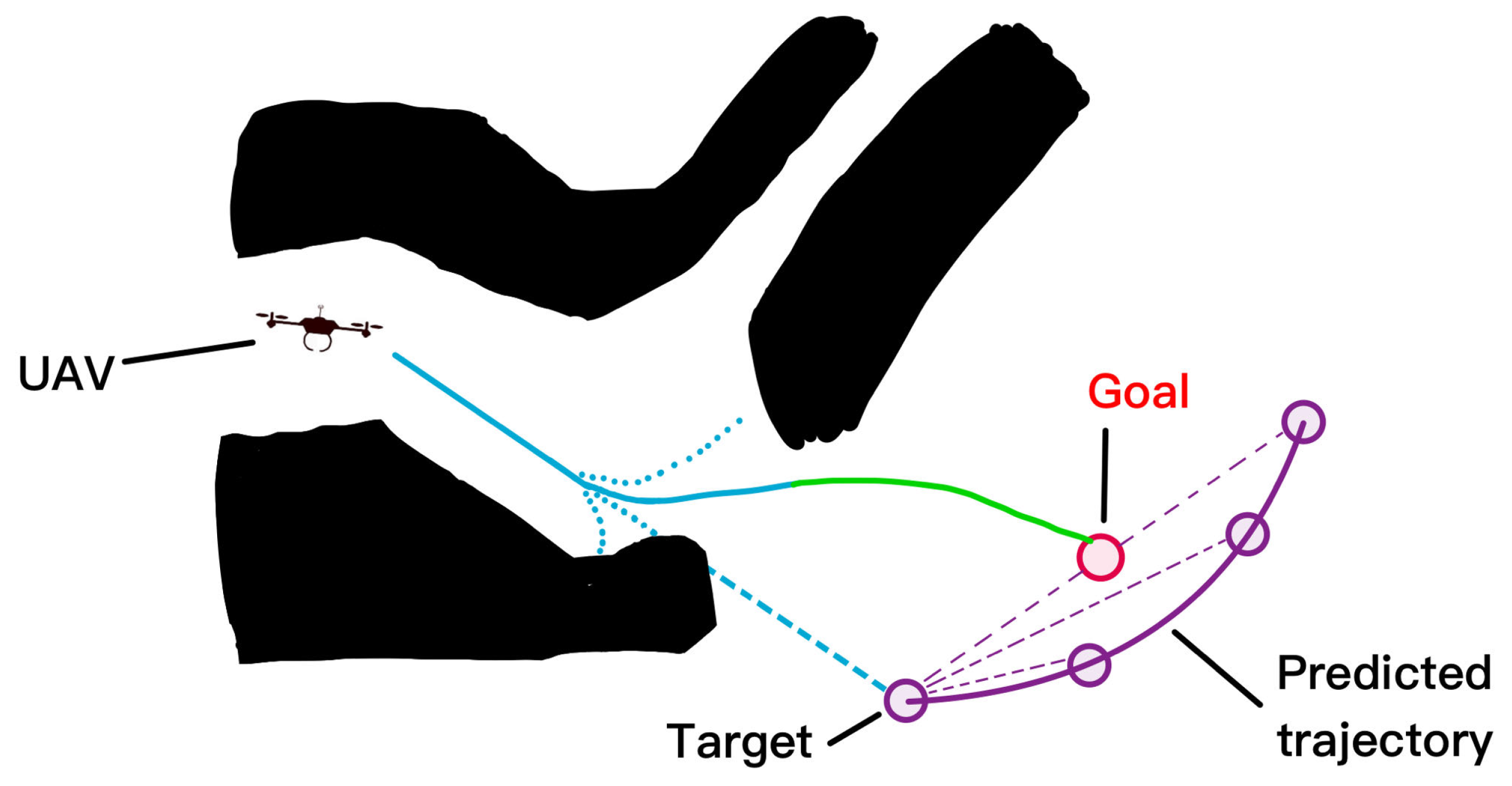
Many methods for UAV path planning have been proposed in recent years. The most common ones are sampling-based methods, such as RRT and PRobability roadmap; there are graph-based methods for designing paths, such as Voronoi graph algorithm, concluded Dijkstra algorithm, A* algorithm, and Markov decision processes [107,108]. It is worth mentioning that [108] integrates target motion prediction with the tracking trajectory planning (as Figure 6 shows), enabling the advanced path planning utility. Applications in this area have been studied as early as 2011; the paper [109] preliminarily addresses SAR using quadrotors. The paper [110] used a hill-climbing algorithm, iteratively, to first find a path at each step by the hill-climbing algorithm, and then optimized the objective function to assign the search effort (flight time) to each cell in the path. The paper [111] broke two assumptions and extended a framework for probabilistic search based on decision-making to merge multiple observations of grid cells and changes in UAV altitude, enabling small, light, low-speed, and agile UAVs, such as quadrotors, to perform occupancy network-based search tasks. The paper [112] presents a path planning method where the UAV is regarded as a Dubins vehicle. The path planning method is based on the tangent graph where the obstacles are abstracted as circles. Then the tangent graph composes of straight lines and arcs on the circles. Finally, the shortest path from a source position to a destination can be found by a graph searching algorithm. However, these algorithms do not consider UAV kinematic and dynamic limitations. Furthermore, these algorithms require prior knowledge of the production map, a requirement that greatly limits their applicability.
Another kind of optimal path-planning approach is the potential field-based method. PF was proposed by Khatib in 1986 [113]. In Potential Fields (PF), Q g o a l and obstacles have attractive and repulsive potentials respectively. The two potential forms the potential field of the UAV, and the resultant force of the magnetic field on the UAV determines its motion direction. Then some algorithms are proposed, such as the artificial potential field and the interfering fluid dynamic [114], to realize global offline path planning. However, because the potential field method leads the vehicle to the minimum value in the field, it often falls into the local minimum value. When the target and the obstacle are close to each other, a feasible route cannot be found.
Biological-Based Path Planning algorithms, which are mainly based on machine learning, have made great progress in recent years with the support of swarm intelligence techniques. Many algorithms have been proposed, and here are a few of them. A Genetic Algorithm (GA) can be used to resolve the constrained and unconstrained optimization problems, but it cannot guarantee an optimal path. Local minima can occur in narrow environments, therefore, lower security and narrow corridor problems need to be avoided [115,116]. Particle Swarm Optimization (PSO) is a classical meta-heuristic population-based algorithm to resolve problems of multiobjective path planning. The paper [117] used simulation to compare the particle swarm optimization (PSO) with the other optimizing algorithms, including layered search and rescue, spiral search, and fish-inspired allocation. They further proposed the algorithm based on the particle swarm optimization algorithm, reducing the collisions without affecting iterations to convergence. The paper [118] proposes an optimal trajectory determination method for multi-robot paths in cluttered environments based on an improved particle swarm optimization algorithm (IPSO) and an improved gravitational search algorithm (IGSA) to minimize the maximum path length required for all robots in the environment to reach their respective destinations. Ant colony optimization algorithm (ACO) is a probabilistic technique for solving computational problems which can be reduced to finding good paths through graphs. In [119], they propose an improved ACO to resolve various Vehicle Routing Problems (VRPs), which is utilized for Unmanned Aerial Vehicle (UAV) task allocation and route planning. At last, the comparison between mentioned path planning algorithms is provided in Table 8 for reference.

Unknown Environments Exploration

It is often important for UAVs to conduct SAR operations under unknown environments, for example, a GPS-denied environment or a place where no pre-stored map is available. Therefore, UAVs will be assigned the task of unknown space exploration. Agents need to formulate an effective exploration strategy along with motion planning to decide how to move in an unknown environment to minimize exploration time and cost. This usually requires UAVs to have the real-time ability to perceive the surrounding environment and adjust strategies.
Plenty of papers focus on developing effective exploration strategies, one of which is the random exploration strategy. With this method, the robot obtains more information by randomly choosing the direction and speed to move in an unknown environment. The Rapidly exploring random trees (RRT) algorithm introduced in the paper [120] is a type of randomized algorithm that constructs a tree-like structure by repeatedly adding new nodes to the existing tree, with the goal of efficiently exploring the search space. RRT has been widely adopted in the robotics community. To further implement the RRT algorithm practically, the sensors are integrated for the environment perception of robots. This strategy is also called Sensor-based Random Tree (SRT) [121,122], a variant of the RRT algorithm. In the SRT algorithm, the robot uses its sensors to check if the proposed connection would collide with any obstacles in the environment before adding the new point to the tree. The paper [123] proposed the improvement of the RRT algorithm implementation. Instead of moving agents using the RRT algorithm, this article uses multiple independent RRT trees to quickly and efficiently search for frontier points to discover unknown areas.
Similar to the RRT algorithm, the Monte Carlo tree search (MCTS) is also proposed for area exploration and path planning. It was first proposed as a framework for game AI in the paper [124], which illustrated the detailed procedures for the MCTS. It is further implemented in path planning of multiple games, including Ms. Pac-Man [125,126] and a two-player turn-based strategy board game called Go (in which the multi-agent Monte Carlo is considered) [127]. Simulation in games has shown positive results.
It is further implemented into robot operations, including the coordination of UAVs in disaster response and casualty discovery [128], and the search and rescue plannings [129]. The Monte Carlo method can estimate the obstacle distribution of the unknown environment through multiple random sampling, and then generate a probability map, based on which the path planning could be operated by UAV agents. A comprehensive review of the Monte Carlo method is presented in [130], which illustrated the development and variants of the Monte Carlo method in detail.
However, the RRT and Monte Carlo methods both belong to the randomness-based exploration strategy, which is very inefficient for exploring large areas or complex environments. This is because agents may repeatedly explore known areas due to the inherited defect of this strategy [131].
To avoid collisions and repeated exploration, a model-based exploration strategy is proposed for robot agents to collect and analyze environmental information. This strategy necessitates the robotic system to model the environment, for instance, by utilizing technologies such as LiDAR or cameras to construct 3D maps. The robot then employs the map information to plan a trajectory and conduct an effective exploration.
In this strategy, the state-of-art method is the simultaneous localization and mapping (SLAM), which is proposed in [132] in 1991. Robots or mobile devices, equipped with sensors such as cameras, and LiDARs, are supplemented by inertial measurement units for capturing information about the environment and their movements. Analysis of this information enables the robot to estimate both its position and the shape of the environment map simultaneously [133]. The paper [134] briefly introduced the development of the SLAM technique. Robots such as drones are equipped with LiDAR sensors and other sensors (such as IMUs) for real-time acquisition of environmental information. By filtering, segmenting, and registering the point cloud data obtained by LiDAR, the computer can extract feature information in the environment, such as walls and corridors. After analyzing the sensor data, the UAV can realize real-time positioning (that is, obtain the position and attitude of the UAV). At the same time, by combining the extracted feature information with the position and attitude information of the drone, a map of the indoor environment can be constructed (for example, LiDAR sensors can generate laser point cloud data for building a three-dimensional map of the environment). After that, the UAV makes navigation decisions based on the constructed map and real-time positioning information, such as path planning, obstacle avoidance, etc., so as to realize the function of environmental exploration.
The paper [135] improved the basic SLAM technique and introduced the FastSLAM algorithm, and it has been further enhanced into FastSLAM 2.0 [136] in 2003. FastSLAM is a classical particle filter-based SLAM algorithm that uses two parallel filters: a particle filter for robot localization and an extended Kalman filter (EKF)-based filter for map building. The FastSLAM 2.0 algorithm uses the Rao–Blackwellized particle filter (RBPF) to simultaneously handle robot position and map building. This improvement can significantly reduce the number of particles required to achieve accurate SLAM results. The paper [137] introduced the Unscented FastSLAM based on the unscented particle filter that uses an unscented Kalman filter (UKF) to further reduce the number of particles, but the UFastSLAM is restricted to nonlinear measurement models. The Differential Evolution technique is proposed in [138] to handle non-linear optimization problems and further enhance the SLAM performance.
Nowadays, SLAM enhances UAVs’ autonomous control and environment perception, resulting in increased efficiency, reliability, and safety. A typical SLAM-based exploration block diagram is introduced in Figure 7 with the basic SLAM function (localization and mapping), planning layer, and communications layer for UAVs teams through the network. The proposed SLAM algorithm in the paper [139] utilizes LiDAR and MEMS IMU (Micro Electro Mechanical System inertial measurement Unit) with a fixed Kalman filter for state estimation, resulting in improved feature extraction accuracy and reduced filtering algorithm computation. The work in paper [140] further demonstrates an enhanced ability to navigate unexplored floors through LiDAR grid construction of orthogonal walls, filtering out static furniture and dynamic human bodies, and utilizing the Linear Quadratic Estimation (LQE) method to assist in calculating the displacement and orientation of the robot. The paper [141] suggests the utilization of RGB-D cameras to obtain dense color and depth images [142] for an onboard UAV SLAM approach. The paper [143] utilizes the visual SLAM to propose the exploration strategy for distributed multi-UAV systems. Regarding the limited connection between each agent, the result shows an obvious reduction in exploration time and traveled distance for both two and three UAVs.
Furthermore, the SLAM-based exploration performance of UAV agents is enhanced by the integration of machine learning [144,145]. Ref. [145] utilizes population coding algorithms and self-learning features to construct a cooperative multi-coupling system for collaborative decision-making in UAV-based SLAM operations. By adopting consensus architecture and neural network training, the drones in the system can reach a consensus and work together to help the system adapt to changing environments and achieve self-adaptation and optimization. The research in [144] realizes the ability to make indoor environmental maps in real-time by combining SLAM and the Single Image Depth Estimation (SIDE) algorithm based on Convolutional Neural Networks (CNN). A learning-based exploration solution is proposed in work [146], which aims at using an end-to-end learning method to obtain the geometric information of the environment directly from RGB images without relying on specialized sensors, resulting in greater flexibility and adaptability. However, the paper [147] stated that this work shows little difference in navigation performance from untrained traditional methods. It proposed the Active Neural SLAM, which achieves fast exploration of unknown areas by modularizing the task and conducting independent training in each module while combining traditional analytical path planners with learning-based SLAM modules. This indicates the combination between the model-based exploration strategy and machine learning has promising prospects for further development.
In conclusion, UAV SLAM technology enables real-time environmental perception and mapping, allowing for the deeper detection and recognition of the environment, such as terrain, obstacles, buildings, and roads. However, the principle of C-SLAM (Collaborative Simultaneous Localization and Mapping) is to achieve a global perspective by integrating the local perspectives of multiple UAVs [148], thereby enabling more accurate topological localization and map construction. The accuracy of map construction and positioning is affected by the number of drones, limitations in network bandwidth, delay, as well as the different frame of reference used by each UAV [149,150].
To overcome the technical limitations in C-SLAM, multi-sensor fusion technology should be further researched and developed to better combine data from different sensors and improve the robustness and accuracy of localization and map construction. At the same time, for communication and data transmission in C-SLAM, the UAV SLAM system should adopt higher-speed data transmission technology and optimize network architecture and protocols to reduce delay and bandwidth limitations. Moreover, the continued development of SLAM technology and algorithms is improving the reliability of the Model-Based Exploration Strategy, along with the enhanced performance of UAV environmental detection. To further enlarge the feasibility of the UAV SLAM under different scenarios, automatic parameter tuning, including thresholds of feature matching, and RANSAC parameters, should be further achieved [151]. This leads to the integration between AI (or learning features) and the SLAM system in future study. For example, machine learning algorithms can leverage large amounts of real data to learn the relationship between the environment and parameters, enabling automatic adjustment of SLAM parameters based on real-time data and environmental changes for improved performance and accuracy.

3.3.3. Collision Avoidance

It is not difficult to find from the above that path planning is to generate a set of path points that bypass obstacles from the initial position to the final goal, while collision avoidance takes a given waypoint assignment as a local goal to avoid obstacles. The rest of this section serves as a survey of these works and presents the development history and the latest research progress of collision avoidance algorithms, especially smart collision avoidance in dense and narrow spaces.
Early collision avoidance algorithms mainly targeted static obstacles. Since path planning also needs to be considered in obstacle avoidance, the predominant idea for obstacle avoidance in the 1970s and 1980s is to construct a configuration space, and many improved path-planning algorithms have been proposed. However, none of these classical algorithms can minimize the input energy and achieve the optimum results while avoiding obstacles. In the middle of the 1980s, some path-planning algorithms considering uncertain and dynamic environments were proposed, such as potential functions [113], control theory, and other heuristic algorithms. These algorithms solve the shortcomings of classical algorithms but still face challenges when dealing with complex moving obstacles. In the 1990s, many local motion planning algorithms were proposed to improve efficiency, such as e dynamic window technology, inevitable collision states, and velocity obstacles. Such algorithms abandon the optimal global solution to improve efficiency and can process inputs in real-time but, because they do not optimize the trajectories subject to time or energy, UAVs will fall into a deadlock when facing dynamic obstacles.
After the 2000s, with the development of new technology and improved hardware computing power, more and more obstacle avoidance algorithms have been proposed, making UAVs more agile and robust. The paper [152] describes the safety evaluation process that the international community has deemed necessary to certify such systems about UAVs. The paper [153] proposes an adaptive tracking controller based on output feedback linearization that compensates for dynamic changes in the quadrotor’s center of gravity. The paper [154] combines the improved Lyapunov Guidance Vector Field (LGVF), the Interfered Fluid Dynamical System (IFDS), and the strategy of varying receding-horizon optimization from Model Predictive Control (MPC) to track the target and avoid obstacles in a complex dynamic environment, Figure 8 presents the demonstration of its Local obstacle avoidance strategy. In [155], a new extended multi-rotor Voliro is proposed, a new type of air platform that can fly in any direction while maintaining any direction, significantly improving the agility of the UAV, and may be used for indoor SAR operations when reduced in size. The work in the paper [156] even accomplishes a rapid 180-degree course reversal for UAVs with minimal computational effort, including a simple feedforward/feedback controller, which was successfully implemented for small fixed-wing UAVs. A new method for autonomous navigation of small unmanned aerial vehicles (UAVs) in artificial forests using only a single camera was proposed using Faster region convolutional neural network (FAR-CNN) to detect tree trunks [157]. The paper [158] proposes a hybrid approach incorporating first principles and learning to model the quadrotor and its aerodynamic effects with unprecedented accuracy, enabling flight close to the physical limits of the platform. Further, the paper [159] presents an online planning method following the framework of model predictive control (MPC) to jointly optimize the motion of the UAV and the configurations of the RISs under the consideration of energy efficiency.
The implementation of non-linear MPC into collision avoidance among multi-UAV agents is proposed in [160]. The critical distance is set with cost penalties for collision-free operations. The paper [161] also introduced the non-linear MPC collision avoidance into object transportation, where the agents are required to transport an object collaboratively. The simulation result proves the validity and convergence of the method. The various task assignment approaches and their features are tabulated in Table 9.

Agile Movement in Tight Spaces

Additionally, the agile movement of drones in confined spaces can provide many benefits for UAV search and rescue operations. UAVs can expeditiously arrive at the intended destination, and their agility and hovering capabilities enable them to promptly respond to search and rescue demands, consequently enhancing the pace of search and rescue endeavors. Furthermore, UAVs can effortlessly penetrate narrow spaces or perilous terrains that are arduous for rescue personnel to access. They can penetrate restricted spaces, edifices, ravines, woodlands, and other arduous-to-reach locales to effectuate search and rescue tasks.
In UAV flight control, the use of model-based control involves creating a mathematical model to represent the UAV’s motion and dynamic characteristics. This allows for precise control of the UAV using techniques such as model predictive control and optimal control. At present, there exist various model-based flight control methods, among which nonlinear dynamic inversion (NDI) [162] is one of them. NDI linearizes the dynamics of an aircraft using an aerodynamic model, which yields a linear system that is fundamentally identical for all aircraft, given that the aerodynamic model is correct. Based on NDI, the paper [163] eliminates the sensitivity of model mismatch and reduces the cost of flight control system design by feeding back angular acceleration. Adaptive control [164,165] is another model-based flight control method. The adaptive parameters are updated in real-time to maintain flight stability by adapting to the environment. The paper [166] further applies the Cerebellar Model Arithmetic Computer (CMAC) to update the adaptive parameters for adapting the varying payload and unknown disturbance simultaneously. Furthermore, the MPC mentioned in the former context is also included in model-based flight control methods.
Practical issues exist in its application. Firstly, the motion and dynamic characteristics of UAVs are complex, making it difficult to establish accurate mathematical models [167]. Secondly, there are many uncertainties and interferences in practical application scenarios, making it challenging to achieve precise model predictive control and optimal control [168]. The instability is also introduced by the deletion of some practical effective terms in models for simplification of calculation [14].
Therefore, combining deep learning with control theory can effectively address these issues and improve the robustness and adaptability of UAV control, which has better prospects for practical applications. The artificial neural network (ANN) is combined with the model-based flight controller for learning complex control systems. The integration enables real-time adaptation and learning of the control system, with relatively simple requirements on hardware and processing procedure. The detailed advantages and limitations are further illustrated in [168], which is listed in Table 10:
The papers [169,170] proposed hybrid supervised neural network models for dynamic systems, using flexible modules in non-recurrent and recurrent networks. The model is evaluated with an autonomous helicopter/UAV system, comparing radial basis and multilayer perceptron with the real system. The results confirmed its feasibility and potential for further investigation. The paper [171] investigates the use of ANN-based dynamic models for control synthesis and demonstrates that even a simple ANN architecture can accurately generalize dynamics beyond training data when coupled with LQR and PD control for trajectory tracking, making it suitable for control purposes. The paper [172] develops a ReLU model that combines a quadratic lag model with a double-layered simple ReLU network. Following training via least-squares regression and stochastic gradient descent, the model exhibits an overall improvement of 58% in acceleration prediction performance.
The paper [173] proposes a control system design using feedback linearization and a neural network for model inversion error. Pseudo Control Hedging is used to protect the adaptive element from non-linearities and the resulting system allows position, velocity, attitude, and angular rate commands. The outer loop allows tracking of position, velocity, attitude, and angular rate with an attitude correction. The paper [174] introduces a hybrid adaptive control method to recover the stability of a damaged aircraft under single damage, in which direct adaptive ANN compensates less dynamic inversion error and the simulation results show good effectiveness of the approach. The paper [175] uses a neural network-based adaptive sliding mode controller to control the altitude of a quadrotor. The paper [176] integrates the ANN into backstepping flight control of a helicopter, and the result presents strong resistance to sudden mass-changing perturbations.
The flight control method combined with the neural network can learn the nonlinear dynamic characteristics of an aircraft, making it highly adaptable and robust, especially for uncertain or unknown nonlinear system characteristics. However, this method requires a considerable amount of data for training, resulting in a longer training time.
Despite the significant contributions of academic research towards the development of technology, the majority of it remains in a simulation stage within the laboratory. This is due to the presence of various assumptions that may not hold in real-world applications or may pose implementation challenges in hardware. Therefore, there is still a considerable distance to cover in the advancement of technology.

4. Future Works

For the future development of drone SAR, a few more problems should be further discussed by taking advantage of fast technology development. The endurance of a single UAV agent is highly limited at present. Compromises are made between the payload and flight duration for the SAR operation. Improving the efficiency of a single drone in locating multiple targets in a search and rescue operation within a limited timeframe is crucial. So, the first future direction: we need more lightweight algorithms to reduce the computational burden of UAVs to improve the efficiency and real-time performance of SAR operations. Take image recognition technology as an example. Image recognition technology plays an important role in improving the efficiency of search and rescue, including the use of advanced deep learning and artificial intelligence algorithms, as well as the integration of multi-modal information to obtain richer and more comprehensive target information, so as to improve the accuracy and robustness of image recognition. However, these algorithms require a high amount of computing power. In the case of limited space for computing power improvement, lightweight algorithms may be another idea.
The second direction is to more robustly control the UAV to achieve more agile flight actions. Most of the actual work being performed today is in high-altitude flight search, and many of the agile flight efforts mentioned in Section 3.3 are just experiments in the ideal environment of the lab, lacking deep access to disaster sites (such as earthquakes or fire debris). However, operations, including searching for survivors and delivering supplies, require drones that can make difficult flights in unknown and hostile environments.
To further enhance the efficiency of the UAV SAR operation, organizing multiple heterogeneous drones into a group for collaborative search and rescue is the third popular research direction in the future. Most of the literature focuses on task allocation algorithms for drone groups based on successfully identified targets at present. More research is required to be focusing on achieving multi-angle and multi-modal information acquisition to enhance the robustness of target search, especially the robustness of visual tracking algorithm, including improvements in UAV ad hoc networks and communication efficiency of drones, as well as enhancing the capability to deal with complex environments and emergencies.

5. Summary and Concluding Remarks

In this paper, we present a comprehensive review of using UAVs for SAR. The applications of UAVs in SAR, including on-site monitoring and modeling, perception and localization of targets, and SAR operations, are elaborated on. In the on-site monitoring and modeling section, the Structure from Motion (SfM) method is introduced as a state-of-the-art technique for modeling the disaster area. Although it attracts much attention as a low-cost effective solution, limitations still exist in input image quality and scene redundancy. The section on Perception and localization of targets introduces plenty of novel solutions with multiple sensors integrated, the general defects that exist in the solutions are the conflicts between the payload and the sensors installed, as many sensors trade their satisfying output quality by the weight and costs.
The SAR operation of UAVs is discussed in Section 3.3, among which the task assignment, path planning, and collision avoidance are further introduced in the SAR operation subsection, including the exploration strategies (e.g., randomness-based and model-based exploration strategies), and the agile control of drones (e.g., model-based control and deep learning combined control). The randomness-based exploration strategies are adaptive and flexible for complex environments and high-dimensional state spaces, but they tend to have relatively high computational costs by generating a large number of path samples in large search spaces and do not guarantee finding the optimal solution. This increases the computational load and also leads robots to move back and forth in areas that have already been explored. In contrast, model-based exploration algorithms (such as integration with the SLAM technique) can generate path samples more selectively during the search process, reducing the search space and improving path planning efficiency. Furthermore, models are often adaptively updated and refined in real-time as the robot moves around the environment and collects sensor data. Therefore, model-based path planning reduces computational costs and makes real-time path planning feasible. Additionally, the model-based control of drones is accurate and predictable because it is based on the mathematical model of the drone’s dynamics, which also brings robustness to sensor noise. However, the adaptability of the model-based strategy is limited. This problem is covered and fixed in the deep learning combined control by training with a large amount of labeled data, but the computational load is expected to be further reduced for better performance.
In conclusion, the use of unmanned aerial vehicles for search and rescue operations is a promising development that has improved the efficiency and effectiveness of SAR missions. The benefits of drones, including ease of deployment, low maintenance cost, high mobility, and sensor integration, make them an attractive option for SAR operations. The continued development of drones and their sensors will optimistically lead to further advancements in the field of SAR, making it possible to save more lives in the event of disasters and emergencies.

Author Contributions

Conceptualization of analytical framework, M.L. and Y.Z.; validation, M.L., Y.Z., H.H. and C.H.; formal analysis, M.L. and Y.Z.; resources, H.H.; data curation, M.L. and Y.Z.; writing—original draft preparation, M.L., Y.Z. and H.H.; writing—review and editing, M.L., Y.Z., C.H. and H.H.; visualization, M.L. and Y.Z.; supervision, C.H. and H.H.; project administration, H.H.; funding acquisition, H.H. All authors have read and agreed to the published version of the manuscript.

Funding

This project was supported by Research Centre for Unmanned Autonomous Systems (RCUAS) [P0046487], Hong Kong Polytechnic University.

Conflicts of Interest

The authors declare no conflict of interest.

Abbreviations

The following abbreviations are used in this manuscript:
UAVUnmanned aerial vehicles
SARSearch and rescue
DTMDigital terrain models
VTOLVertical take-off and landing
ESCElectronic speed controllers
UAVBSUnmanned aerial vehicles base stations
CFDComputational fluid dynamics
GNSSGlobal navigation satellite system
UWBultra-wideband
TDOATime difference of arrival
LTELong term evolution
SfMStructure from Motion
SURFspeeded-up robust features
CNNconvolutional neural network
DIRLDeep inverse reinforcement learning
HOGhistograms of oriented gradients
DRLDeep reinforcement learning
MDPMarkov decision process
VRPSNVehicle Routing Problems with synchronous network
VRPVehicle Routing Problems
RRTRapidly exploring random trees
MCTSMonte Carlo tree search
SLAMSimultaneous Localization and Mapping
ANNArtificial neural network

References

  1. Giordan, D.; Adams, M.S.; Aicardi, I.; Alicandro, M.; Allasia, P.; Baldo, M.; De Berardinis, P.; Dominici, D.; Godone, D.; Hobbs, P.; et al. The use of unmanned aerial vehicles (UAVs) for engineering geology applications. Bull. Eng. Geol. Environ. 2020, 79, 3437–3481. [Google Scholar] [CrossRef] [Green Version]
  2. Niedzielski, T.; Jurecka, M.; Miziński, B.; Pawul, W.; Motyl, T. First Successful Rescue of a Lost Person Using the Human Detection System: A Case Study from Beskid Niski (SE Poland). Remote Sens. 2021, 13, 4903. [Google Scholar] [CrossRef]
  3. Giordan, D.; Dematteis, N.; Troilo, F. UAV observation of the recent evolution of the Planpincieux Glacier (Mont Blanc-Italy). In Proceedings of the EGU General Assembly Conference Abstracts, Online, 4–8 May 2020; p. 9906. [Google Scholar]
  4. Silvagni, M.; Tonoli, A.; Zenerino, E.; Chiaberge, M. Multipurpose UAV for search and rescue operations in mountain avalanche events. Geomat. Nat. Hazards Risk 2017, 8, 18–33. [Google Scholar] [CrossRef] [Green Version]
  5. Bejiga, M.B.; Zeggada, A.; Melgani, F. Convolutional neural networks for near real-time object detection from UAV imagery in avalanche search and rescue operations. In Proceedings of the 2016 IEEE International Geoscience and Remote Sensing Symposium (IGARSS), Beijing, China, 10–15 July 2016; pp. 693–696. [Google Scholar] [CrossRef]
  6. Bejiga, M.B.; Zeggada, A.; Nouffidj, A.; Melgani, F. A Convolutional Neural Network Approach for Assisting Avalanche Search and Rescue Operations with UAV Imagery. Remote Sens. 2017, 9, 100. [Google Scholar] [CrossRef] [Green Version]
  7. Yeong, S.; King, L.; Dol, S. A review on marine search and rescue operations using unmanned aerial vehicles. Int. J. Mar. Environ. Sci. 2015, 9, 396–399. [Google Scholar]
  8. Fernández, F.; Besada, E.; Sánchez, D.; López-Orozco, J. Expert guidance system for unmanned aerial vehicles based on artifical neural networks. J. Marit. Res. 2011, 8, 49–64. [Google Scholar]
  9. Rodin, C.D.; de Lima, L.N.; de Alcantara Andrade, F.A.; Haddad, D.B.; Johansen, T.A.; Storvold, R. Object Classification in Thermal Images using Convolutional Neural Networks for Search and Rescue Missions with Unmanned Aerial Systems. In Proceedings of the 2018 International Joint Conference on Neural Networks (IJCNN), Rio de Janeiro, Brazil, 8–13 July 2018; pp. 1–8. [Google Scholar] [CrossRef] [Green Version]
  10. Ajith, V.; Jolly, K. Unmanned aerial systems in search and rescue applications with their path planning: A review. J. Phys. Conf. Ser. 2021, 2115, 012020. [Google Scholar] [CrossRef]
  11. Seddon, J.M.; Newman, S. Basic Helicopter Aerodynamics; John Wiley & Sons: Hoboken, NJ, USA, 2011. [Google Scholar]
  12. Cai, G.; Chen, B.M.; Dong, X.; Lee, T.H. Design and implementation of a robust and nonlinear flight control system for an unmanned helicopter. Special Issue on Development of Autonomous Unmanned Aerial Vehicles. Mechatronics 2011, 21, 803–820. [Google Scholar] [CrossRef]
  13. Oktay, T.; Sultan, C. Simultaneous Helicopter and Control-System Design. J. Aircr. 2013, 50, 911–925. [Google Scholar] [CrossRef] [Green Version]
  14. Hoffmann, G.; Huang, H.; Waslander, S.; Tomlin, C. Quadrotor Helicopter Flight Dynamics and Control: Theory and Experiment. In Proceedings of the AIAA Guidance, Navigation and Control Conference and Exhibit, Hilton Head, SC, USA, 20–23 August 2007. [Google Scholar]
  15. Fernando, H.C.T.E.; De Silva, A.T.A.; De Zoysa, M.D.C.; Dilshan, K.A.D.C.; Munasinghe, S.R. Modelling, simulation and implementation of a quadrotor UAV. In Proceedings of the 2013 IEEE 8th International Conference on Industrial and Information Systems, Peradeniya, Sri Lanka, 17–20 December 2013; pp. 207–212. [Google Scholar] [CrossRef]
  16. Kontogiannis, S.G.; Ekaterinaris, J.A. Design, performance evaluation and optimization of a UAV. Aerosp. Sci. Technol. 2013, 29, 339–350. [Google Scholar] [CrossRef]
  17. Harvey, B.; O’Young, S. Acoustic Detection of a Fixed-Wing UAV. Drones 2018, 2, 4. [Google Scholar] [CrossRef] [Green Version]
  18. Austin, R. Unmanned Aircraft Systems: UAVS Design, Development and Deployment; John Wiley & Sons: Hoboken, NJ, USA, 2011. [Google Scholar]
  19. Paredes, J.A.; Saito, C.; Abarca, M.; Cuellar, F. Study of effects of high-altitude environments on multicopter and fixed-wing UAVs’ energy consumption and flight time. In Proceedings of the 2017 13th IEEE Conference on Automation Science and Engineering (CASE), Xi’an, China, 20–23 August 2017; pp. 1645–1650. [Google Scholar] [CrossRef]
  20. Gu, H.; Lyu, X.; Li, Z.; Shen, S.; Zhang, F. Development and experimental verification of a hybrid vertical take-off and landing (VTOL) unmanned aerial vehicle (UAV). In Proceedings of the 2017 International Conference on Unmanned Aircraft Systems (ICUAS), Miami, FL, USA, 13–16 June 2017; pp. 160–169. [Google Scholar]
  21. Zaludin, Z.; Gires, E. Automatic Flight Control Requirements for Transition Flight Phases When Converting Long Endurance Fixed Wing UAV to VTOL Aircraft. In Proceedings of the 2019 IEEE International Conference on Automatic Control and Intelligent Systems (I2CACIS), Selangor, Malaysia, 29–29 June 2019; pp. 273–278. [Google Scholar] [CrossRef]
  22. Erdos, D.; Erdos, A.; Watkins, S.E. An experimental UAV system for search and rescue challenge. IEEE Aerosp. Electron. Syst. Mag. 2013, 28, 32–37. [Google Scholar] [CrossRef]
  23. Apvrille, L.; Tanzi, T.; Dugelay, J.L. Autonomous drones for assisting rescue services within the context of natural disasters. In Proceedings of the 2014 XXXIth URSI General Assembly and Scientific Symposium (URSI GASS), Beijing, China, 16–23 August 2014; pp. 1–4. [Google Scholar] [CrossRef]
  24. Scherer, J.; Yahyanejad, S.; Hayat, S.; Yanmaz, E.; Andre, T.; Khan, A.; Vukadinovic, V.; Bettstetter, C.; Hellwagner, H.; Rinner, B. An Autonomous Multi-UAV System for Search and Rescue; Association for Computing Machinery: New York, NY, USA, 2015; DroNet’15; pp. 33–38. [Google Scholar] [CrossRef]
  25. Alsamhi, S.H.; Shvetsov, A.V.; Kumar, S.; Shvetsova, S.V.; Alhartomi, M.A.; Hawbani, A.; Rajput, N.S.; Srivastava, S.; Saif, A.; Nyangaresi, V.O. UAV Computing-Assisted Search and Rescue Mission Framework for Disaster and Harsh Environment Mitigation. Drones 2022, 6, 154. [Google Scholar] [CrossRef]
  26. Dahal, C.; Dura, H.; Poudel, L. Design and Analysis of Propeller for High Altitude Search and Rescue Unmanned Aerial Vehicle. Int. J. Aerosp. Eng. 2021, 2021, 13. [Google Scholar] [CrossRef]
  27. Li, B.; Ma, L.; Wang, D.; Sun, Y. Driving and tilt-hovering—An agile and manoeuvrable aerial vehicle with tiltable rotors. IET Cyber-Syst. Robot. 2021, 3, 103–115. [Google Scholar] [CrossRef]
  28. Zeng, Y.; Zhang, R.; Lim, T.J. Wireless communications with unmanned aerial vehicles: Opportunities and challenges. IEEE Commun. Mag. 2016, 54, 36–42. [Google Scholar] [CrossRef] [Green Version]
  29. Mozaffari, M.; Saad, W.; Bennis, M.; Debbah, M. Optimal transport theory for power-efficient deployment of unmanned aerial vehicles. In Proceedings of the 2016 IEEE International Conference on Communications (ICC), Kuala Lumpur, Malaysia, 22–27 May 2016; pp. 1–6. [Google Scholar] [CrossRef] [Green Version]
  30. Farahani, R.Z.; SteadieSeifi, M.; Asgari, N. Multiple criteria facility location problems: A survey. Appl. Math. Model. 2010, 34, 1689–1709. [Google Scholar] [CrossRef]
  31. Alzenad, M.; El-Keyi, A.; Yanikomeroglu, H. 3-D Placement of an Unmanned Aerial Vehicle Base Station for Maximum Coverage of Users With Different QoS Requirements. IEEE Wirel. Commun. Lett. 2018, 7, 38–41. [Google Scholar] [CrossRef] [Green Version]
  32. Hayajneh, K.F.; Bani-Hani, K.; Shakhatreh, H.; Anan, M.; Sawalmeh, A. 3d deployment of unmanned aerial vehicle-base station assisting ground-base station. Wirel. Commun. Mob. Comput. 2021, 2021, 1–11. [Google Scholar] [CrossRef]
  33. Day, R.; Salmon, J. A Framework for Multi-UAV Persistent Search and Retrieval with Stochastic Target Appearance in a Continuous Space. J. Intell. Robot. Syst. 2021, 103, 65. [Google Scholar] [CrossRef]
  34. Petráček, P.; Krátký, V.; Petrlík, M.; Báča, T.; Kratochvíl, R.; Saska, M. Large-Scale Exploration of Cave Environments by Unmanned Aerial Vehicles. IEEE Robot. Autom. Lett. 2021, 6, 7596–7603. [Google Scholar] [CrossRef]
  35. Zhu, X.; Vanegas, F.; Gonzalez, F.; Sanderson, C. A Multi-UAV System for Exploration and Target Finding in Cluttered and GPS-Denied Environments. In Proceedings of the 2021 International Conference on Unmanned Aircraft Systems (ICUAS), Athens, Greece, 15–18 June 2021; pp. 721–729. [Google Scholar]
  36. Tiemann, J.; Eckermann, F.; Wietfeld, C. ATLAS—An open-source TDOA-based Ultra-wideband localization system. In Proceedings of the 2016 International Conference on Indoor Positioning and Indoor Navigation (IPIN), Alcala de Henares, Spain, 4–7 October 2016; pp. 1–6. [Google Scholar] [CrossRef]
  37. Tiemann, J.; Wietfeld, C. Scalable and precise multi-UAV indoor navigation using TDOA-based UWB localization. In Proceedings of the 2017 International Conference on Indoor Positioning and Indoor Navigation (IPIN), Sapporo, Japan, 18–21 September 2017; pp. 1–7. [Google Scholar] [CrossRef]
  38. Gorczak, P.; Bektas, C.; Kurtz, F.; Lübcke, T.; Wietfeld, C. Robust Cellular Communications for Unmanned Aerial Vehicles in Maritime Search and Rescue. In Proceedings of the 2019 IEEE International Symposium on Safety, Security, and Rescue Robotics (SSRR), Wurzburg, Germany, 2–4 September 2019; pp. 229–234. [Google Scholar] [CrossRef] [Green Version]
  39. Zheng, L.; Hu, J.; Xu, S. Marine Search and Rescue of UAV in Long-Distance Security Modeling Simulation. Pol. Marit. Res. 2017, 24, 192–199. [Google Scholar] [CrossRef] [Green Version]
  40. Alwateer, M.; Loke, S.W.; Fernando, N. Enabling drone services: Drone crowdsourcing and drone scripting. IEEE Access 2019, 7, 110035–110049. [Google Scholar] [CrossRef]
  41. Townsend, A.; Jiya, I.N.; Martinson, C.; Bessarabov, D.; Gouws, R. A comprehensive review of energy sources for unmanned aerial vehicles, their shortfalls and opportunities for improvements. Heliyon 2020, 6, e05285. [Google Scholar] [CrossRef] [PubMed]
  42. Wu, J.; Wang, H.; Li, N.; Yao, P.; Huang, Y.; Yang, H. Path planning for solar-powered UAV in urban environment. Neurocomputing 2018, 275, 2055–2065. [Google Scholar] [CrossRef]
  43. Lun, Y.; Wang, H.; Wu, J.; Liu, Y.; Wang, Y. Target Search in Dynamic Environments with Multiple Solar-Powered UAVs. IEEE Trans. Veh. Technol. 2022, 71, 9309–9321. [Google Scholar] [CrossRef]
  44. Wu, J.; Wang, H.; Huang, Y.; Su, Z.; Zhang, M. Energy management strategy for solar-powered UAV long-endurance target tracking. IEEE Trans. Aerosp. Electron. Syst. 2018, 55, 1878–1891. [Google Scholar] [CrossRef]
  45. Uragun, B. Energy Efficiency for Unmanned Aerial Vehicles. In Proceedings of the 2011 10th International Conference on Machine Learning and Applications and Workshops, Honolulu, HI, USA, 18–21 December 2011; Volume 2, pp. 316–320. [Google Scholar] [CrossRef]
  46. Yang, Z.; Xu, W.; Shikh-Bahaei, M. Energy Efficient UAV Communication with Energy Harvesting. IEEE Trans. Veh. Technol. 2020, 69, 1913–1927. [Google Scholar] [CrossRef] [Green Version]
  47. Ouamri, M.A.; Barb, G.; Singh, D.; Adam, A.B.M.; Muthanna, M.S.A.; Li, X. Nonlinear Energy-Harvesting for D2D Networks Underlaying UAV with SWIPT Using MADQN. IEEE Commun. Lett. 2023. early access. [Google Scholar] [CrossRef]
  48. Yadav, A.K.; Gaur, P. AI-based adaptive control and design of autopilot system for nonlinear UAV. Sadhana 2014, 39, 765–783. [Google Scholar] [CrossRef] [Green Version]
  49. Rezwan, S.; Choi, W. Artificial Intelligence Approaches for UAV Navigation: Recent Advances and Future Challenges. IEEE Access 2022, 10, 26320–26339. [Google Scholar] [CrossRef]
  50. Wu, J.; Wang, H.; Liu, Y.; Zhang, M.; Wu, T. Learning-based fixed-wing UAV reactive maneuver control for obstacle avoidance. Aerosp. Sci. Technol. 2022, 126, 107623. [Google Scholar] [CrossRef]
  51. Al-Turjman, F.; Zahmatkesh, H. Al-Turjman, F.; Zahmatkesh, H. A comprehensive review on the use of AI in UAV communications: Enabling technologies, applications, and challenges. In Unmanned Aerial Vehicles in Smart Cities; Springer: Berlin/Heidelberg, Germany, 2020; pp. 1–26. [Google Scholar]
  52. Qi, J.; Song, D.; Shang, H.; Wang, N.; Hua, C.; Wu, C.; Qi, X.; Han, J. Search and Rescue Rotary-Wing UAV and Its Application to the Lushan Ms 7.0 Earthquake. J. Field Robot. 2016, 33, 290–321. Available online: https://onlinelibrary.wiley.com/doi/pdf/10.1002/rob.21615 (accessed on 13 April 2023). [CrossRef]
  53. Neitzel, F.; Klonowski, J. Mobile 3D mapping with a low-cost UAV system. Int. Arch. Photogramm. Remote Sens. Spat. Inf. Sci 2011, 38, C22. [Google Scholar] [CrossRef] [Green Version]
  54. Westoby, M.; Brasington, J.; Glasser, N.; Hambrey, M.; Reynolds, J. ‘Structure-from-Motion’ photogrammetry: A low-cost, effective tool for geoscience applications. Geomorphology 2012, 179, 300–314. [Google Scholar] [CrossRef] [Green Version]
  55. Verykokou, S.; Doulamis, A.; Athanasiou, G.; Ioannidis, C.; Amditis, A. UAV-based 3D modelling of disaster scenes for Urban Search and Rescue. In Proceedings of the 2016 IEEE International Conference on Imaging Systems and Techniques (IST), Chania, Greece, 4–6 October 2016; pp. 106–111. [Google Scholar] [CrossRef]
  56. Skondras, A.; Karachaliou, E.; Tavantzis, I.; Tokas, N.; Valari, E.; Skalidi, I.; Bouvet, G.A.; Stylianidis, E. UAV Mapping and 3D Modeling as a Tool for Promotion and Management of the Urban Space. Drones 2022, 6, 115. [Google Scholar] [CrossRef]
  57. Feng, Q.; Liu, J.; Gong, J. Urban Flood Mapping Based on Unmanned Aerial Vehicle Remote Sensing and Random Forest Classifier—A Case of Yuyao, China. Water 2015, 7, 1437–1455. [Google Scholar] [CrossRef]
  58. Rezaldi, M.Y.; Yoganingrum, A.; Hanifa, N.R.; Kaneda, Y.; Kushadiani, S.K.; Prasetyadi, A.; Nugroho, B.; Riyanto, A.M. Unmanned Aerial Vehicle (UAV) and Photogrammetric Technic for 3D Tsunamis Safety Modeling in Cilacap, Indonesia. Appl. Sci. 2021, 11, 11310. [Google Scholar] [CrossRef]
  59. Marfai, M.A.; Fatchurohman, H.; Cahyadi, A. An evaluation of tsunami hazard modeling in Gunungkidul Coastal Area using UAV Photogrammetry and GIS. Case study: Drini Coastal Area. In E3S Web of Conferences; EDP Sciences: Les Ulis, France, 2019; Volume 125, p. 09005. [Google Scholar]
  60. Choi, S.s.; Kim, E.k. Building crack inspection using small UAV. In Proceedings of the 2015 17th International Conference on Advanced Communication Technology (ICACT), Pyeong Chang, Republic of Korea, 1–3 July 2015; pp. 235–238. [Google Scholar] [CrossRef]
  61. Gillins, M.N.; Gillins, D.T.; Parrish, C. Cost-effective bridge safety inspections using unmanned aircraft systems (UAS). In Proceedings of the Geotechnical and Structural Engineering Congress 2016, Phoenix, Arizona, 14–17 February 2016; pp. 1931–1940. [Google Scholar]
  62. Eschmann, C.; Kuo, C.; Kuo, C.-M.; Boller, C. Unmanned aircraft systems for remote building inspection and monitoring. In Proceedings of the 6th European Workshop on Structural Health Monitoring (EWSHM 2012), Dresden, Germany, 3–6 July 2012; pp. 1179–1186. [Google Scholar]
  63. Lattanzi, D.A.; Miller, G. A prototype imaging and visualization system for robotic infrastructure inspection. In Structures Congress 2013: Bridging Your Passion with Your Profession; ASCE: Reston, VI, USA, 2013; pp. 410–421. [Google Scholar]
  64. Dorafshan, S.; Thomas, R.J.; Maguire, M. Fatigue Crack Detection Using Unmanned Aerial Systems in Fracture Critical Inspection of Steel Bridges. J. Bridge Eng. 2018, 23, 04018078. [Google Scholar] [CrossRef]
  65. Morgenthal, G.; Hallermann, N. Quality assessment of unmanned aerial vehicle (UAV) based visual inspection of structures. Adv. Struct. Eng. 2014, 17, 289–302. [Google Scholar] [CrossRef]
  66. Meyer, D.; Hess, M.; Lo, E.; Wittich, C.E.; Hutchinson, T.C.; Kuester, F. UAV-based post disaster assessment of cultural heritage sites following the 2014 South Napa Earthquake. In Proceedings of the 2015 Digital Heritage, Granada, Spain, 28 September–2 October 2015; Volume 2, pp. 421–424. [Google Scholar] [CrossRef]
  67. Akbar, M.A.; Qidwai, U.; Jahanshahi, M.R. An evaluation of image-based structural health monitoring using integrated unmanned aerial vehicle platform. Struct. Control Health Monit. 2019, 26, e2276. [Google Scholar] [CrossRef] [Green Version]
  68. Xiong, C.; Li, Q.; Lu, X. Automated regional seismic damage assessment of buildings using an unmanned aerial vehicle and a convolutional neural network. Autom. Constr. 2020, 109, 102994. [Google Scholar] [CrossRef]
  69. Tan, Y.; Li, G.; Cai, R.; Ma, J.; Wang, M. Mapping and modelling defect data from UAV captured images to BIM for building external wall inspection. Autom. Constr. 2022, 139, 104284. [Google Scholar] [CrossRef]
  70. He, H.; Xu, H.; Zhang, Y.; Gao, K.; Li, H.; Ma, L.; Li, J. Mask R-CNN based automated identification and extraction of oil well sites. Int. J. Appl. Earth Obs. Geoinf. 2022, 112, 102875. [Google Scholar] [CrossRef]
  71. Fernandez Galarreta, J.; Kerle, N.; Gerke, M. UAV-based urban structural damage assessment using object-based image analysis and semantic reasoning. Nat. Hazards Earth Syst. Sci. 2015, 15, 1087–1101. [Google Scholar] [CrossRef] [Green Version]
  72. Vetrivel, A.; Gerke, M.; Kerle, N.; Vosselman, G. Identification of damage in buildings based on gaps in 3D point clouds from very high resolution oblique airborne images. ISPRS J. Photogramm. Remote Sens. 2015, 105, 61–78. [Google Scholar] [CrossRef]
  73. Van Tilburg, C. First Report of Using Portable Unmanned Aircraft Systems (Drones) for Search and Rescue. Wilderness Environ. Med. 2017, 28, 116–118. [Google Scholar] [CrossRef] [Green Version]
  74. Andriluka, M.; Schnitzspan, P.; Meyer, J.; Kohlbrecher, S.; Petersen, K.; von Stryk, O.; Roth, S.; Schiele, B. Vision based victim detection from unmanned aerial vehicles. In Proceedings of the 2010 IEEE/RSJ International Conference on Intelligent Robots and Systems, Taipei, Taiwan, 18–22 October 2010; pp. 1740–1747. [Google Scholar] [CrossRef] [Green Version]
  75. Rabiner, L. A tutorial on hidden Markov models and selected applications in speech recognition. Proc. IEEE 1989, 77, 257–286. [Google Scholar] [CrossRef] [Green Version]
  76. Martinez-Alpiste, I.; Golcarenarenji, G.; Wang, Q.; Alcaraz-Calero, J.M. Search and rescue operation using UAVs: A case study. Expert Syst. Appl. 2021, 178, 114937. [Google Scholar] [CrossRef]
  77. Cao, Y.; Qi, F.; Jing, Y.; Zhu, M.; Lei, T.; Li, Z.; Xia, J.; Wang, J.; Lu, G. Mission Chain Driven Unmanned Aerial Vehicle Swarms Cooperation for the Search and Rescue of Outdoor Injured Human Targets. Drones 2022, 6, 138. [Google Scholar] [CrossRef]
  78. Murphy, S.O.; Sreenan, C.; Brown, K.N. Autonomous Unmanned Aerial Vehicle for Search and Rescue Using Software Defined Radio. In Proceedings of the 2019 IEEE 89th Vehicular Technology Conference (VTC2019-Spring), Kuala Lumpur, Malaysia, 28 April–1 May 2019; pp. 1–6. [Google Scholar] [CrossRef]
  79. Albanese, A.; Sciancalepore, V.; Costa-Pérez, X. SARDO: An Automated Search-and-Rescue Drone-based Solution for Victims Localization. IEEE Trans. Mob. Comput. 2022, 21, 3312–3325. [Google Scholar] [CrossRef]
  80. Dinh, T.D.; Pirmagomedov, R.; Pham, V.D.; Ahmed, A.A.; Kirichek, R.; Glushakov, R.; Vladyko, A. Unmanned aerial system–assisted wilderness search and rescue mission. Int. J. Distrib. Sens. Netw. 2019, 15, 1550147719850719. [Google Scholar] [CrossRef]
  81. Weldon, W.T.; Hupy, J. Investigating Methods for Integrating Unmanned Aerial Systems in Search and Rescue Operations. Drones 2020, 4, 38. [Google Scholar] [CrossRef]
  82. Goodrich, M.A.; Morse, B.S.; Gerhardt, D.; Cooper, J.L.; Quigley, M.; Adams, J.A.; Humphrey, C. Supporting wilderness search and rescue using a camera-equipped mini UAV. J. Field Robot. 2008, 25, 89–110. [Google Scholar] [CrossRef]
  83. Burke, C.; McWhirter, P.R.; Veitch-Michaelis, J.; McAree, O.; Pointon, H.A.; Wich, S.; Longmore, S. Requirements and Limitations of Thermal Drones for Effective Search and Rescue in Marine and Coastal Areas. Drones 2019, 3, 78. [Google Scholar] [CrossRef] [Green Version]
  84. Sun, J.; Li, B.; Jiang, Y.; Wen, C.y. A Camera-Based Target Detection and Positioning UAV System for Search and Rescue (SAR) Purposes. Sensors 2016, 16, 1778. [Google Scholar] [CrossRef] [Green Version]
  85. Valsan, A.; Parvathy, B.; GH, V.D.; Unnikrishnan, R.; Reddy, P.K.; Vivek, A. Unmanned Aerial Vehicle for Search and Rescue Mission. In Proceedings of the 2020 4th International Conference on Trends in Electronics and Informatics (ICOEI) (48184), Tirunelveli, India, 15–17 June 2020; pp. 684–687. [Google Scholar] [CrossRef]
  86. McGee, J.; Mathew, S.J.; Gonzalez, F. Unmanned Aerial Vehicle and Artificial Intelligence for Thermal Target Detection in Search and Rescue Applications. In Proceedings of the 2020 International Conference on Unmanned Aircraft Systems (ICUAS), Athens, Greece, 1–4 September 2020; pp. 883–891. [Google Scholar] [CrossRef]
  87. Doherty, P.; Rudol, P. A UAV Search and Rescue Scenario with Human Body Detection and Geolocalization. In AI 2007: Advances in Artificial Intelligence; Orgun, M.A., Thornton, J., Eds.; Springer: Berlin/Heidelberg, Germany, 2007; pp. 1–13. [Google Scholar]
  88. Rudol, P.; Doherty, P. Human Body Detection and Geolocalization for UAV Search and Rescue Missions Using Color and Thermal Imagery. In Proceedings of the 2008 IEEE Aerospace Conference, Big Sky, MT, USA, 1–8 March 2008; pp. 1–8. [Google Scholar] [CrossRef]
  89. Lu, B.X.; Wu, J.J.; Tsai, Y.C.; Jiang, W.T.; Tseng, K.S. A Novel Telerobotic Search System using an Unmanned Aerial Vehicle. In Proceedings of the 2020 Fourth IEEE International Conference on Robotic Computing (IRC), Taichung, Taiwan, 9–11 November 2020; pp. 151–155. [Google Scholar] [CrossRef]
  90. Shima, T.; Rasmussen, S.J.; Sparks, A.G.; Passino, K.M. Multiple task assignments for cooperating uninhabited aerial vehicles using genetic algorithms. Comput. Oper. Res. 2006, 33, 3252–3269. [Google Scholar] [CrossRef]
  91. Ye, F.; Chen, J.; Tian, Y.; Jiang, T. Cooperative task assignment of a heterogeneous multi-UAV system using an adaptive genetic algorithm. Electronics 2020, 9, 687. [Google Scholar] [CrossRef] [Green Version]
  92. Huang, H.; Zhuo, T. Multi-model cooperative task assignment and path planning of multiple UCAV formation. Multimed. Tools Appl. 2019, 78, 415–436. [Google Scholar] [CrossRef]
  93. Deng, Q.; Yu, J.; Wang, N. Cooperative task assignment of multiple heterogeneous unmanned aerial vehicles using a modified genetic algorithm with multi-type genes. Chin. J. Aeronaut. 2013, 26, 1238–1250. [Google Scholar] [CrossRef] [Green Version]
  94. Delle Fave, F.M.; Rogers, A.; Xu, Z.; Sukkarieh, S.; Jennings, N.R. Deploying the max-sum algorithm for decentralised coordination and task allocation of unmanned aerial vehicles for live aerial imagery collection. In Proceedings of the 2012 IEEE International Conference on Robotics and Automation, Saint Paul, MN, USA, 14–18 May 2012; pp. 469–476. [Google Scholar]
  95. Koubâa, A.; Qureshi, B.; Sriti, M.F.; Allouch, A.; Javed, Y.; Alajlan, M.; Cheikhrouhou, O.; Khalgui, M.; Tovar, E. Dronemap Planner: A service-oriented cloud-based management system for the Internet-of-Drones. Ad Hoc Netw. 2019, 86, 46–62. [Google Scholar] [CrossRef]
  96. Huang, H.; Savkin, A.V.; Huang, C. Reliable path planning for drone delivery using a stochastic time-dependent public transportation network. IEEE Trans. Intell. Transp. Syst. 2020, 22, 4941–4950. [Google Scholar] [CrossRef]
  97. Kurdi, H.; How, J.; Bautista, G. Bio-inspired algorithm for task allocation in multi-uav search and rescue missions. In Proceedings of the AIAA Guidance, Navigation, and Control Conference, San Diego, CA, USA, 4–8 January 2016; p. 1377. [Google Scholar]
  98. Oh, G.; Kim, Y.; Ahn, J.; Choi, H.L. Market-based task assignment for cooperative timing missions in dynamic environments. J. Intell. Robot. Syst. 2017, 87, 97–123. [Google Scholar] [CrossRef]
  99. Koubâa, A.; Cheikhrouhou, O.; Bennaceur, H.; Sriti, M.F.; Javed, Y.; Ammar, A. Move and improve: A market-based mechanism for the multiple depot multiple travelling salesmen problem. J. Intell. Robot. Syst. 2017, 85, 307–330. [Google Scholar] [CrossRef]
  100. Ongaro, D.; Ousterhout, J. In search of an understandable consensus algorithm. In Proceedings of the 2014 USENIX Annual Technical Conference (USENIX ATC 14), Philadelphia, PA, USA, 19–20 June 2014; pp. 305–319. [Google Scholar]
  101. Kim, I.; Morrison, J.R. Learning based framework for joint task allocation and system design in stochastic multi-UAV systems. In Proceedings of the 2018 International Conference on Unmanned Aircraft Systems (ICUAS), Dallas, TX, USA, 12–15 June 2018; pp. 324–334. [Google Scholar]
  102. Liang, X.; Chen, G.; Zhao, S.; Xiu, Y. Moving target tracking method for unmanned aerial vehicle/unmanned ground vehicle heterogeneous system based on AprilTags. Meas. Control 2020, 53, 427–440. [Google Scholar] [CrossRef] [Green Version]
  103. Huang, H.; Savkin, A.V. Aerial Surveillance in Cities: When UAVs Take Public Transportation Vehicles. IEEE Trans. Autom. Sci. Eng. 2023, 20, 1069–1080. [Google Scholar] [CrossRef]
  104. Kent, T.; Richards, A.; Johnson, A. Homogeneous Agent Behaviours for the Multi-Agent Simultaneous Searching and Routing Problem. Drones 2022, 6, 51. [Google Scholar] [CrossRef]
  105. Huang, H.; Savkin, A.V.; Ni, W. Online UAV Trajectory Planning for Covert Video Surveillance of Mobile Targets. IEEE Trans. Autom. Sci. Eng. 2022, 19, 735–746. [Google Scholar] [CrossRef]
  106. Ribeiro, R.G.; Cota, L.P.; Euzébio, T.A.; Ramírez, J.A.; Guimarães, F.G. Unmanned-aerial-vehicle routing problem with mobile charging stations for assisting search and rescue missions in postdisaster scenarios. IEEE Trans. Syst. Man Cybern. Syst. 2021, 52, 6682–6696. [Google Scholar] [CrossRef]
  107. Atif, M.; Ahmad, R.; Ahmad, W.; Zhao, L.; Rodrigues, J.J. UAV-assisted wireless localization for search and rescue. IEEE Syst. J. 2021, 15, 3261–3272. [Google Scholar] [CrossRef]
  108. Han, Z.; Zhang, R.; Pan, N.; Xu, C.; Gao, F. Fast-tracker: A robust aerial system for tracking agile target in cluttered environments. In Proceedings of the 2021 IEEE International Conference on Robotics and Automation (ICRA), Xi’an, China, 30 May–5 June 2021; pp. 328–334. [Google Scholar]
  109. Almurib, H.A.; Nathan, P.T.; Kumar, T.N. Control and path planning of quadrotor aerial vehicles for search and rescue. In Proceedings of the SICE Annual Conference 2011, Tokyo, Japan, 13–18 September 2011; pp. 700–705. [Google Scholar]
  110. Agcayazi, M.T.; Cawi, E.; Jurgenson, A.; Ghassemi, P.; Cook, G. ResQuad: Toward a semi-autonomous wilderness search and rescue unmanned aerial system. In Proceedings of the 2016 International Conference on Unmanned Aircraft Systems (ICUAS), Arlington, VA, USA, 7–10 June 2016; pp. 898–904. [Google Scholar]
  111. Waharte, S.; Symington, A.; Trigoni, N. Probabilistic search with agile UAVs. In Proceedings of the 2010 IEEE International Conference on Robotics and Automation, Anchorage, AK, USA, 3–7 May 2010; pp. 2840–2845. [Google Scholar]
  112. Savkin, A.V.; Huang, H. Optimal Aircraft Planar Navigation in Static Threat Environments. IEEE Trans. Aerosp. Electron. Syst. 2017, 53, 2413–2426. [Google Scholar] [CrossRef]
  113. Khatib, O. Real-time obstacle avoidance for manipulators and mobile robots. Int. J. Robot. Res. 1986, 5, 90–98. [Google Scholar] [CrossRef]
  114. Zhang, Z.; Wu, J.; Dai, J.; He, C. A novel real-time penetration path planning algorithm for stealth UAV in 3D complex dynamic environment. IEEE Access 2020, 8, 122757–122771. [Google Scholar] [CrossRef]
  115. Li, D.; Wang, X.; Sun, T. Energy-optimal coverage path planning on topographic map for environment survey with unmanned aerial vehicles. Electron. Lett. 2016, 52, 699–701. [Google Scholar] [CrossRef]
  116. Dogru, S.; Marques, L. Energy efficient coverage path planning for autonomous mobile robots on 3D terrain. In Proceedings of the 2015 IEEE International Conference on Autonomous Robot Systems and Competition, Vila Real, Portugal, 8–10 April 2015; pp. 118–123. [Google Scholar]
  117. Kumar, G.; Anwar, A.; Dikshit, A.; Poddar, A.; Soni, U.; Song, W. Obstacle avoidance for a swarm of unmanned aerial vehicles operating on particle swarm optimization: A swarm intelligence approach for search and rescue missions. J. Braz. Soc. Mech. Sci. Eng. 2022, 44, 56. [Google Scholar] [CrossRef]
  118. Das, P.K.; Behera, H.S.; Panigrahi, B.K. A hybridization of an improved particle swarm optimization and gravitational search algorithm for multi-robot path planning. Swarm Evol. Comput. 2016, 28, 14–28. [Google Scholar] [CrossRef]
  119. Zaza, T.; Richards, A. Ant colony optimization for routing and tasking problems for teams of UAVs. In Proceedings of the 2014 UKACC International Conference on Control (CONTROL), Loughborough, UK, 9–11 July 2014; pp. 652–655. [Google Scholar]
  120. Kothari, M.; Postlethwaite, I.; Gu, D.W. Multi-UAV path planning in obstacle rich environments using Rapidly-exploring Random Trees. In Proceedings of the 48h IEEE Conference on Decision and Control (CDC) held jointly with 2009 28th Chinese Control Conference, Shanghai, China, 15–18 December 2009; pp. 3069–3074. [Google Scholar]
  121. Oriolo, G.; Vendittelli, M.; Freda, L.; Troso, G. The SRT method: Randomized strategies for exploration. In Proceedings of the IEEE International Conference on Robotics and Automation, 2004. Proceedings. ICRA’04. 2004, New Orleans, LA, USA, 26 April–1 May 2004; Volume 5, pp. 4688–4694. [Google Scholar] [CrossRef] [Green Version]
  122. Freda, L.; Loiudice, F.; Oriolo, G. A Randomized Method for Integrated Exploration. In Proceedings of the 2006 IEEE/RSJ International Conference on Intelligent Robots and Systems, Beijing, China, 9–15 October 2006; pp. 2457–2464. [Google Scholar] [CrossRef]
  123. Umari, H.; Mukhopadhyay, S. Autonomous robotic exploration based on multiple rapidly-exploring randomized trees. In Proceedings of the 2017 IEEE/RSJ International Conference on Intelligent Robots and Systems (IROS), Vancouver, BC, Canada, 24–28 September 2017; pp. 1396–1402. [Google Scholar] [CrossRef]
  124. Chaslot, G.; Bakkes, S.; Szita, I.; Spronck, P. Monte-Carlo Tree Search: A New Framework for Game AI. Proc. AAAI Conf. Artif. Intell. Interact. Digit. Entertain. 2021, 4, 216–217. [Google Scholar] [CrossRef]
  125. Tong, B.K.B.; Ma, C.M.; Sung, C.W. A Monte-Carlo approach for the endgame of Ms. Pac-Man. In Proceedings of the 2011 IEEE Conference on Computational Intelligence and Games (CIG’11), Seoul, Republic of Korea, 31 August–3 September 2011; pp. 9–15. [Google Scholar] [CrossRef]
  126. Tong, B.K.B.; Sung, C.W. A Monte-Carlo approach for ghost avoidance in the Ms. Pac-Man game. In Proceedings of the 2010 2nd International IEEE Consumer Electronics Society’s Games Innovations Conference, Hong Kong, China, 21–23 December 2010; pp. 1–8. [Google Scholar] [CrossRef]
  127. Soriano Marcolino, L.; Matsubara, H. Multi-agent Monte Carlo Go. In Proceedings of the AAMAS’11: The Tenth International Conference on Autonomous Agents and Multiagent Systems, Taipei, Taiwan, 2–6 May 2011; Volume 1, pp. 21–28. [Google Scholar]
  128. Baker, C.; Ramchurn, G.; Teacy, L.; Jennings, N. Factored Monte-Carlo tree search for coordinating UAVs in disaster response. In Proceedings of the ICAPS 4th Workshop on Distributed and Multi-Agent Planning (DMAP-2016), London, UK, 13 June 2016; pp. 6–15. [Google Scholar]
  129. Baker, C.A.B.; Ramchurn, S.; Teacy, W.L.; Jennings, N.R. Planning Search and Rescue Missions for UAV Teams. In Proceedings of the Twenty-Second European Conference on Artificial Intelligence, The Hague, The Netherlands, 29 August–2 September 2016; pp. 1777–1778. [Google Scholar] [CrossRef]
  130. Browne, C.B.; Powley, E.; Whitehouse, D.; Lucas, S.M.; Cowling, P.I.; Rohlfshagen, P.; Tavener, S.; Perez, D.; Samothrakis, S.; Colton, S. A Survey of Monte Carlo Tree Search Methods. IEEE Trans. Comput. Intell. AI Games 2012, 4, 1–43. [Google Scholar] [CrossRef] [Green Version]
  131. George, J.; PB, S.; Sousa, J.B. Search strategies for multiple UAV search and destroy missions. J. Intell. Robot. Syst. 2011, 61, 355–367. [Google Scholar] [CrossRef]
  132. Leonard, J.J.; Durrant-Whyte, H.F. Mobile robot localization by tracking geometric beacons. IEEE Trans. Robot. Autom. 1991, 7, 376–382. [Google Scholar] [CrossRef]
  133. Bailey, T.; Durrant-Whyte, H. Simultaneous localization and mapping (SLAM): Part II. IEEE Robot. Autom. Mag. 2006, 13, 108–117. [Google Scholar] [CrossRef] [Green Version]
  134. Khairuddin, A.R.; Talib, M.S.; Haron, H. Review on simultaneous localization and mapping (SLAM). In Proceedings of the 2015 IEEE International Conference on Control System, Computing and Engineering (ICCSCE), Penang, Malaysia, 27–29 November 2015; pp. 85–90. [Google Scholar] [CrossRef]
  135. Montemerlo, Michael. FastSLAM: A Factored Solution to the Simultaneous Localization and Mapping Problem with Unknown Data Association. Ph.D. Thesis, Carnegie Mellon University, Pittsburgh, PA, USA, 2003.
  136. Montemerlo, M.; Thrun, S.; Koller, D.; Wegbreit, B. FastSLAM 2.0: An improved particle filtering algorithm for simultaneous localization and mapping that provably converges. In Proceedings of the IJCAI’03: Proceedings of the 18th International Joint Conference on Artificial Intelligence, Acapulco, Mexico, 9–15 August 2003; pp. 1151–1156.
  137. Kim, C.; Sakthivel, R.; Chung, W.K. Unscented FastSLAM: A Robust Algorithm for the Simultaneous Localization and Mapping Problem. In Proceedings of the 2007 IEEE International Conference on Robotics and Automation, Rome, Italy, 10–14 April 2007; pp. 2439–2445. [Google Scholar] [CrossRef]
  138. Moreno, L.; Garrido, S.; Blanco, D.; Muñoz, M.L. Differential evolution solution to the SLAM problem. Robot. Auton. Syst. 2009, 57, 441–450. [Google Scholar] [CrossRef]
  139. Li, R.; Liu, J.; Zhang, L.; Hang, Y. LIDAR/MEMS IMU integrated navigation (SLAM) method for a small UAV in indoor environments. In Proceedings of the 2014 DGON Inertial Sensors and Systems (ISS), Karlsruhe, Germany, 16–17 September 2014; pp. 1–15. [Google Scholar] [CrossRef]
  140. Ismail, H.; Roy, R.; Sheu, L.J.; Chieng, W.H.; Tang, L.C. Exploration-Based SLAM (e-SLAM) for the Indoor Mobile Robot Using Lidar. Sensors 2022, 22, 1689. [Google Scholar] [CrossRef]
  141. Aguilar, W.G.; Rodríguez, G.A.; Álvarez, L.; Sandoval, S.; Quisaguano, F.; Limaico, A. Visual SLAM with a RGB-D Camera on a Quadrotor UAV Using on-Board Processing. In Advances in Computational Intelligence; Rojas, I., Joya, G., Catala, A., Eds.; Springer International Publishing: Cham, Switzerland, 2017; pp. 596–606. [Google Scholar]
  142. Kerl, C.; Sturm, J.; Cremers, D. Dense visual SLAM for RGB-D cameras. In Proceedings of the 2013 IEEE/RSJ International Conference on Intelligent Robots and Systems, Tokyo, Japan, 3–7 November 2013; pp. 2100–2106. [Google Scholar]
  143. Mahdoui, N.; Frémont, V.; Natalizio, E. Communicating multi-uav system for cooperative slam-based exploration. J. Intell. Robot. Syst. 2020, 98, 325–343. [Google Scholar] [CrossRef] [Green Version]
  144. Steenbeek, A.; Nex, F. CNN-based dense monocular visual SLAM for real-time UAV exploration in emergency conditions. Drones 2022, 6, 79. [Google Scholar] [CrossRef]
  145. Rai, A.; Kannan, R.J. Population coding of generative neuronal cells for collaborative decision making in UAV-based SLAM operations. J. Indian Soc. Remote Sens. 2021, 49, 499–505. [Google Scholar] [CrossRef]
  146. Chen, T.; Gupta, S.; Gupta, A. Learning Exploration Policies for Navigation. In Proceedings of the International Conference on Learning Representations, New Orleans, LA, USA, 6–9 May 2019. [Google Scholar]
  147. Chaplot, D.S.; Gandhi, D.; Gupta, S.; Gupta, A.; Salakhutdinov, R. Learning to Explore using Active Neural SLAM. arXiv 2020, arXiv:2004.051552020. [Google Scholar]
  148. Hu, J.; Zhang, H.; Li, Z.; Zhao, C.; Xu, Z.; Pan, Q. Object traversing by monocular UAV in outdoor environment. Asian J. Control 2021, 23, 2766–2775. [Google Scholar] [CrossRef]
  149. Shao, P.; Mo, F.; Chen, Y.; Ding, N.; Huang, R. Monocular Object SLAM using Quadrics and Landmark Reference Map for Outdoor UAV Applications. In Proceedings of the 2021 IEEE International Conference on Real-time Computing and Robotics (RCAR), Xining, China, 15–19 July 2021; pp. 1195–1201. [Google Scholar]
  150. Chen, Q.; Zhu, H.; Yang, L.; Chen, X.; Pollin, S.; Vinogradov, E. Edge computing assisted autonomous flight for UAV: Synergies between vision and communications. IEEE Commun. Mag. 2021, 59, 28–33. [Google Scholar] [CrossRef]
  151. Cadena, C.; Carlone, L.; Carrillo, H.; Latif, Y.; Scaramuzza, D.; Neira, J.; Reid, I.; Leonard, J.J. Past, Present, and Future of Simultaneous Localization and Mapping: Toward the Robust-Perception Age. IEEE Trans. Robot. 2016, 32, 1309–1332. [Google Scholar] [CrossRef] [Green Version]
  152. Kuchar, J.K. Safety analysis methodology for unmanned aerial vehicle (UAV) collision avoidance systems. In Proceedings of the Usa/Europe Air Traffic Management r&d Seminars, Baltimore, MA, USA, 27–30 June 2005; Volume 12. [Google Scholar]
  153. Palunko, I.; Fierro, R. Adaptive control of a quadrotor with dynamic changes in the center of gravity. IFAC Proc. Vol. 2011, 44, 2626–2631. [Google Scholar] [CrossRef] [Green Version]
  154. Yao, P.; Wang, H.; Su, Z. Real-time path planning of unmanned aerial vehicle for target tracking and obstacle avoidance in complex dynamic environment. Aerosp. Sci. Technol. 2015, 47, 269–279. [Google Scholar] [CrossRef]
  155. Kamel, M.; Verling, S.; Elkhatib, O.; Sprecher, C.; Wulkop, P.; Taylor, Z.; Siegwart, R.; Gilitschenski, I. The voliro omniorientational hexacopter: An agile and maneuverable tiltable-rotor aerial vehicle. IEEE Robot. Autom. Mag. 2018, 25, 34–44. [Google Scholar] [CrossRef] [Green Version]
  156. Levin, J.M.; Paranjape, A.A.; Nahon, M. Agile maneuvering with a small fixed-wing unmanned aerial vehicle. Robot. Auton. Syst. 2019, 116, 148–161. [Google Scholar] [CrossRef]
  157. Lee, H.; Ho, H.W.; Zhou, Y. Deep Learning-based Monocular Obstacle Avoidance for Unmanned Aerial Vehicle Navigation in Tree Plantations: Faster Region-based Convolutional Neural Network Approach. J. Intell. Robot. Syst. 2021, 101, 5. [Google Scholar] [CrossRef]
  158. Bauersfeld, L.; Kaufmann, E.; Foehn, P.; Sun, S.; Scaramuzza, D. Neurobem: Hybrid aerodynamic quadrotor model. arXiv 2021, arXiv:2106.08015. [Google Scholar]
  159. Huang, H.; Eskandari, M.; Savkin, A.; Ni, W. Energy-efficient joint UAV secure communication and 3D trajectory optimization assisted by reconfigurable intelligent surfaces in the presence of eavesdroppers. Def. Technol. 2022; in press. [Google Scholar] [CrossRef]
  160. Chao, Z.; Zhou, S.L.; Ming, L.; Zhang, W.G. UAV formation flight based on nonlinear model predictive control. Math. Probl. Eng. 2012, 2012, 261367. [Google Scholar] [CrossRef] [Green Version]
  161. Nikou, A.; Verginis, C.; Heshmati-alamdari, S.; Dimarogonas, D.V. A Nonlinear Model Predictive Control scheme for cooperative manipulation with singularity and collision avoidance. In Proceedings of the 2017 25th Mediterranean Conference on Control and Automation (MED), Valletta, Malta, 3–6 July 2017; pp. 707–712. [Google Scholar] [CrossRef] [Green Version]
  162. Voos, H. Nonlinear control of a quadrotor micro-UAV using feedback-linearization. In Proceedings of the 2009 IEEE International Conference on Mechatronics, Malaga, Spain, 14–17 April 2009; pp. 1–6. [Google Scholar] [CrossRef] [Green Version]
  163. Sieberling, S.; Chu, Q.; Mulder, J. Robust flight control using incremental nonlinear dynamic inversion and angular acceleration prediction. J. Guid. Control. Dyn. 2010, 33, 1732–1742. [Google Scholar] [CrossRef]
  164. Lavretsky, E. Combined/Composite Model Reference Adaptive Control. IEEE Trans. Autom. Control 2009, 54, 2692–2697. [Google Scholar] [CrossRef]
  165. Duarte-Mermoud, M.A.; Rioseco, J.S.; González, R.I. Control of longitudinal movement of a plane using combined model reference adaptive control. Aircr. Eng. Aerosp. Technol. 2005, 77, 199–213. [Google Scholar] [CrossRef]
  166. Nicol, C.; Macnab, C.; Ramirez-Serrano, A. Robust adaptive control of a quadrotor helicopter. Mechatronics 2011, 21, 927–938. [Google Scholar] [CrossRef]
  167. Santoso, F.; Garratt, M.A.; Anavatti, S.G. State-of-the-Art Intelligent Flight Control Systems in Unmanned Aerial Vehicles. IEEE Trans. Autom. Sci. Eng. 2018, 15, 613–627. [Google Scholar] [CrossRef]
  168. Gu, W.; Valavanis, K.P.; Rutherford, M.J.; Rizzo, A. A Survey of Artificial Neural Networks with Model-based Control Techniques for Flight Control of Unmanned Aerial Vehicles. In Proceedings of the 2019 International Conference on Unmanned Aircraft Systems (ICUAS), Atlanta, GA, USA, 11–14 June 2019; pp. 362–371. [Google Scholar] [CrossRef]
  169. Punjani, A.; Abbeel, P. Deep learning helicopter dynamics models. In Proceedings of the 2015 IEEE International Conference on Robotics and Automation (ICRA), Seattle, WA, USA, 26–30 May 2015; pp. 3223–3230. [Google Scholar] [CrossRef]
  170. Martin, R.S.; Barrientos, A.; Gutierrez, P.; del Cerro, J. Neural Networks Training Architecture for UAV Modelling. In Proceedings of the 2006 World Automation Congress, Budapest, Hungary, 24–26 July 2006; pp. 1–6. [Google Scholar] [CrossRef]
  171. Bansal, S.; Akametalu, A.K.; Jiang, F.J.; Laine, F.; Tomlin, C.J. Learning Quadrotor Dynamics Using Neural Network for Flight Control. In Proceedings of the 2016 IEEE 55th Conference on Decision and Control (CoRR), Las Vegas, NV, USA, 12–14 December 2016. [Google Scholar]
  172. San Martin, R.; Barrientos, A.; Gutiérrez, P.; Cerro, J. Unmanned Aerial Vehicle (UAV) Modelling based on Supervised Neural Networks. In Proceedings of the 2006 IEEE International Conference on Robotics and Automation, Orlando, FL, USA, 15–19 May 2006; pp. 2497–2502. [Google Scholar] [CrossRef]
  173. Kannan, S.; Johnson, E. Adaptive trajectory based control for autonomous helicopters. In Proceedings of the 21st Digital Avionics Systems Conference, Irvine, CA, USA, 27–31 October 2002; Volume 2, p. 8D1. [Google Scholar] [CrossRef] [Green Version]
  174. Nguyen, N.; Krishnakumar, K.; Kaneshige, J. Dynamics and Adaptive Control for Stability Recovery of Damaged Asymmetric Aircraft. In Proceedings of the AIAA Guidance, Navigation, and Control Conference and Exhibit, Keystone, CO, USA, 21–24 August 2006. [Google Scholar] [CrossRef] [Green Version]
  175. Li, S.; Wang, Y.; Tan, J.; Zheng, Y. Adaptive RBFNNs/integral sliding mode control for a quadrotor aircraft. Neurocomputing 2016, 216, 126–134. [Google Scholar] [CrossRef]
  176. Madani, T.; Benallegue, A. Adaptive Control via Backstepping Technique and Neural Networks of a Quadrotor Helicopter. IFAC Proc. Vol. 2008, 41, 6513–6518. [Google Scholar] [CrossRef] [Green Version]
Figure 1. Schematic diagram of unmanned helicopter [12].
Remotesensing 15 03266 g001
Figure 2. Figure of Quadcopter X [15].
Remotesensing 15 03266 g002
Figure 3. Figure of fixed wing UAV [17].
Remotesensing 15 03266 g003
Figure 4. Figure of hybrid UAV [21].
Remotesensing 15 03266 g004
Figure 5. Illustration of CNN.
Remotesensing 15 03266 g005
Figure 6. Path planning when tracking a target in [108].
Remotesensing 15 03266 g006
Figure 7. Architecture block diagram of SLAM-based exploration in [143].
Remotesensing 15 03266 g007
Figure 8. Local obstacle avoidance strategy in [154].
Remotesensing 15 03266 g008
Table 1. The UAV classification and corresponding pros and cons.
UAV ClassificationAdvantageLimitation
Helicopteragile under complex environmenthigh-cost maintenance
Fixed winglong-range maneuverlarge scale range of activities
Multirotoragile and VTOLlarge battery consumption
HybridVTOL and long-range maneuvermore drag and weight
Table 2. Pros and cons of papers relating to UAV-communication.
PaperAdvantagesDisadvantages
 [28]- a networking architecture for constructing wireless communication networks in connection-disabled areas using UAV teams.- Communication strategy is elaborated by assumption.
 [29]- facility location framework to determine the location of the UAV base station and minimize the total transmit power.- Acquisition of user locations and optimization of distribution should be further illustrated.
 [31]- the three-dimensional deployment of UAV base stations for maximum user coverage with different quality of service.- Quality of service requirements are not clearly defined.
 [32]- a model for a UAV base station providing services to randomly distributed users.- Charging strategy of UAV base station is not discussed.
 [33]- a framework for multi-UAV teams to search for targets that stochastically appear in continuous space with random elements.- Experiment only achieved in simulation without detailed target recognition and task allocation process.
Table 3. Summary of the Characteristics of the Papers relating to 3D-modelling.
PaperCharacteristicDescription
 [53]- Introduction of a low-cost UAV system for 3D modeling- Presents a low-cost solution to construct 3D point clouds from digital images using a UAV system
 [54]- Introduction of the Structure from Motion (SfM) concept for 3D modeling- Presents the SfM concept as a low-cost solution to compensate for camera motion and estimate the 3D model of the object based on image or video stream
 [55]- Comparison of different photogrammetric software- Compares two different photogrammetric software, PhotoScan and MicMac, in terms of parameter settings, imaging time, and precision, and concludes that PhotoScan is more applicable for SAR operation
 [56]- Establishment of the 3D model using open-source 3D rendering software- Establishes a 3D model of Pylaia, Greece, using Pix4D Mapper for SfM and Blender for rendering to provide a detailed reference of the city scene for public use
 [57]- Mapping of an urban flood using Random Forest
Classifier
- Utilizes a mini-UAV to provide video streaming for mapping the waterlogging area inside Yuyao city, China, and applies RGB images and texture information as input of the Random Forest Classifier to output the submerged area of the city with a high accuracy of 87.3%
 [58]- Building of a 3D city model integrated with a tsunami model- Utilizes a UAV to build a 3D city model of Cilacap, Indonesia, integrated with a tsunami model to simulate the authentic circumstances under the strike of the tsunami and help plan evacuation paths for the public
 [59]- Generation of inundation scenarios using UAV 3D
modeling
- Conducts an experiment in Drini Coastal Area to generate multiple inundation scenarios for predicting the circumstances and finding the safe area in tsunami disaster
Table 4. Summary of papers on UAV-based structural damage inspection.
PaperMain Content
 [65]Discussed the UAV flight requirement for building inspection.
 [67]Implemented image stitching using SURF algorithm and demonstrated the feasibility of using UAVs for structural damage inspection
 [60]Developed an image collection system with Canny mask and edge detection for defect detection
 [64]Introduced a method for bridge fatigue detection using UAVs
 [62]Proposed a post-processing photograph-based method for building defect detection
 [71]Developed a method for assessing building structural damage, generating 3D point clouds to distinguish fully damaged structures
 [61]Presented a method for bridge inspection using video
 [63]Proposed a computer vision-based method for building and bridge defect detection
 [66]Proposed an optimized path and camera setting for UAV systems to perform 3D modeling and damage analysis
 [69]Applied Mask-R-CNN-based deep learning to UAV-captured images to detect defects on building external walls, and integrated the information into BIM models
 [72]Proposed a gap classification method for point cloud-based damage assessment
 [68]Used a convolutional neural network to distinguish collapsed and damaged buildings in seismic disaster areas, and generated 3D models for detailed analysis
Table 5. Literature with techniques used.
LiteratureHOGCNNSVMHSVHMMRSSICellphone Signal
 [74]x
 [6] xxxx
 [75] x
 [9] x
 [5] x
 [76] x
 [77] x
 [78] xx
 [79] x xx
 [80] x
Table 6. Typical literature works with their technique utilization in UAV SAR operations.
Sensors and TechniquePaperAdvantagesDisadvantages
RGB camera[81,87,88]Low cost, high efficiencyLimited contrast
ultrasonic sensors[85]Collision avoidanceLimited detection range
Thermal camera[83,85,86,87,88]Detection ability under certain conditionsLimited robustness under different environments
Video processing[82]Temporary localized mosaic view increase the operator’s efficiencyDecision making heavily relies on human operator
Table 7. Comparison of task assignment algorithms for UAVs.
ReferenceAlgorithmAdvantagesDisadvantages
Shima et al. [90]Genetic algorithmsCentralized optimization; suitable for providing good solutions for high dimensional problemsCommunication overhead; slow to respond to dynamic changes; the choice of cost function has a great influence on algorithm performance
Deng et al. [93]Genetic algorithmsCentralized optimization; modified to solve heterogeneity in UAV swarmLimited communication; susceptible to system failures
Delle Monache et al. [94]Max-sumCentralized optimization; suitable for a wide range of UAV applications including task assignment in SARNeed to replan entire assignment for each time period
Kurdi et al. [97]Opportunistic task allocation strategy (OTA)Distributed optimization; simple and suitable for emergency situations where there is a serious lack of information at the disaster siteEfficiency of search and rescue is erratic
Oh et al. [98]Market-based methodsDistributed optimization; task allocation is more reasonableBid negotiation consumes more time and computing resource transmission
Ongaro et al. [100]Raft algorithmDistributed consensus algorithm; easy to understand in design and excellent in performance\
Kim et al. [101]Deep reinforcement learningIncorporates learning; in small examples, the DRL-based approach is much faster than value iteration and obtained nearly optimal solutionsNeed a lot of computational power in a large example
Huang et al. [103]Heterogeneous collaborative systems for vehicles and UAVsUAVs and public transport work together to greatly improve the range of UAVs that can perform tasksAffected by the ground traffic conditions
Table 8. Comparison of path planning algorithms for UAVs.
ReferenceAlgorithmAdvantagesDisadvantages
 [106]VRP with synchronous network (VRPSN)Efficient use of UAV and mobile charging stationLimited applicability
 [107,108,112]Graph-based methodsSimple to understand and easy to implementKinematic and dynamic limitations, require prior knowledge of production map
 [113,114]Potential Field-based methodGlobal offline path planning, good performance in terms of path length and collision avoidanceLocal minimum problem, cannot find feasible route when target and obstacle are too close
 [115,116]Genetic Algorithm (GA)Can resolve constrained and unconstrained optimization problemsLower security and narrow corridor problems need to be avoided
 [117]Particle Swarm Optimization (PSO)Good performance in multiobjective path planningLimited applicability, need to avoid narrow corridor problem
 [118]A hybridization of IPSO–IGSA algorithmThe performance is better than other meta-heuristic algorithms such as IGSABoth the environment and obstacles are static relative to the robot
Table 9. Pros and cons of collision avoidance algorithms for UAVs.
ReferenceAlgorithmAdvantagesDisadvantages
 [113]Potential functionsCan achieve the optimum results while avoiding obstaclesDifficulty dealing with complex moving obstacles
 [154]LGVF and IFDS MPCSimple principle, high computational efficiency and strong practicalityThe real-time performance is poor
 [157]Deep Learning-based monocular obstacle avoidanceAchieve flight with complex, real-world environment cluttered with many obstaclesLimited flight speed
Table 10. Merits and limitations of ANN-integrated model-based flight controller.
MeritsLimitations
Can identify nonlinear and multi-variable systems.Require large amounts of training data.
Can learn and adapt in real-time.Can learn spurious relationships, leading to poor generalization.
Relatively simple processing procedures and hardware implementation.Lack of interpretability due to black-box nature.
Disclaimer/Publisher’s Note: The statements, opinions and data contained in all publications are solely those of the individual author(s) and contributor(s) and not of MDPI and/or the editor(s). MDPI and/or the editor(s) disclaim responsibility for any injury to people or property resulting from any ideas, methods, instructions or products referred to in the content.

