
A Framework for the Construction of a Heritage Corridor System: A Case Study of the Shu Road in China

Tourism and Urban-Rural Planning College, Chengdu University of Technology, Chengdu 610059, China
*
Author to whom correspondence should be addressed.
Remote Sens. 2023, 15(19), 4650; https://doi.org/10.3390/rs15194650
Submission received: 21 July 2023
/
Revised: 11 September 2023
/
Accepted: 19 September 2023
/
Published: 22 September 2023
(This article belongs to the Special Issue Remote Sensing and Geospatial Approaches for Studying the Environment Affected by Human Activities)
Abstract
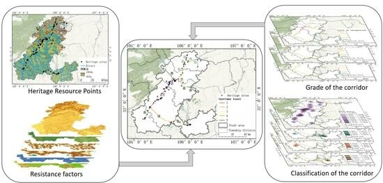
:Heritage corridors are methods to effectively protect and utilize linear cultural heritage based on the concept of regional conservation. The construction of a heritage corridor system is extremely important to preserve the natural environment of the heritage corridor area as well as the history and culture alongside. The majority of the research on the construction of heritage corridors heretofore focused on the generation of corridors, whereas studies on the classification of corridors are relatively limited, without a complete system for the construction of heritage corridors. Therefore, this paper aimed to (1) establish a comprehensive system for the construction of heritage corridors, (2) provide new ideas for the construction of heritage corridors, and (3) guide the scientific development of heritage corridors combining conservation and tourism. In the first place, the minimum cumulative resistance (MCR) model was applied to analyze the spatial structure of the study area and explore site selection of the heritage corridors; secondly, spatial syntax was used to measure the heritage corridors and determine the level of the heritage corridors; last but not least, the kernel density analysis was used to classify the types of heritage corridors. The present study shows that the heritage corridor system is built in a scientific approach, covering all aspects including construction, protection, and development.
1. Introduction
Since the mid-19th century, the conservation of historical and cultural heritage has gradually become a focused problem around the world. The concern of heritage conservation has shifted from individual heritage to historical sites, with expanded range and incisive content [1]. In this context, the concept of heritage corridors was proposed. Heritage corridors originated in the United States in the 1980s, developed from the concept of the greenway [2]. Heritage corridors are linear cultural landscapes with special collections of cultural resources, and the conservation objects can be natural river valleys, canals, roads, and railway lines, or linear corridors of historical significance that connect individual heritage sites [3,4,5]. Until 2023, the United States had seven officially named heritage corridors and one named heritage canal within the 55 designated National Heritage Areas. Other typical heritage corridors include the Rideau Canal in Canada, the route of Santiago de Compostela in Spain, the Midi Canal in France, and the Kumano Kodo Trail in Japan, to name a few. Heritage corridors are of comprehensive conservation measure that promote the simultaneous and balanced development of nature, the economy, history, and culture. Therefore, the construction of heritage corridors is not only a meaningful way to realize the harmonious development of heritage conservation, tourism economic development, and ecological sustainability [6,7], but also a vigorous improvement for the cultural status and reputation of tourist places [8].
The construction of heritage corridors primarily includes generation, grading, and classification. (1) Various methods of corridor generation have been applied at home and abroad such as the qualitative analysis method [9,10,11], analytic hierarchy process [12,13], and minimum cumulative resistance (MCR) model [14,15,16] As the most prominent method to construct heritage corridors, the MCR model calculates the cost of a species’ movement from the source to the destination, and primarily focuses on horizontal ecological processes. It was first applied to establish ecological security patterns for biodiversity conservation [17,18]. As the minimum cumulative resistance (MCR) model is being employed by a growing number of researchers, the method has been gradually applied for urban land use analysis [19,20], ecological pattern analysis [21], and corridor suitability analysis [22,23,24]. The model can calculate the least costly path based on the spatial unit resistance index, which takes full consideration of the geographical and behavioral characteristics with advanced operability and feasibility [25]. (2) In terms of the grading of heritage corridors, literature analysis [26] and connectivity indices [27,28,29] are usually used to assist with the analysis. The literature analysis method is mainly based on the researcher’s analysis of a large amount of literature to obtain the grading results, of which the quality may be compromised by the skill of the associated researchers; the connectivity index is a measure of the corridor connectivity but lacks the visualization of the corridor characteristics. The concept of spatial syntax, officially introduced by Hillier et al. in 1984, is employed for the research of space as an independent element to outline the relationship among architectural, social, and cognitive domains and space [30]. The primary application field of spatial syntax includes spatial morphology [31,32], urban planning and design [33,34], and architectural design [35,36], while further development of the spatial syntax theory and method enables the spatial analysis of street and road networks [37,38]. In the road analysis, corridors can be characterized from multiple perspectives such as connectivity, choice, and integration. The results can be visualized in ArcGIS, which overcomes the drawbacks of the aforementioned and is more accurate and objective. (3) Most studies are deficient in the consideration of heritage corridor classification. Classification is a core component of heritage corridor studies regarding refined conservation, development themes, and the functional positioning of heritage corridors. Kernel density analysis is extensively applied in spatial clustering analysis, which can intuitively obtain the aggregation and dispersion characteristics of point data to describe the distribution characteristics [39]. By using kernel density analysis, the degree of clustering and dispersion for different types of heritage sites can be visualized, which provides scientific guidance for the classification of heritage corridors.
This paper introduces spatial syntax and kernel density analysis based on the least cumulative resistance model to conduct a hierarchical classification study of heritage corridors with the aim of providing new ideas for the construction of heritage corridors and scientific guidance for the protection and tourism development of heritage corridors. The objectives of this study are as follows: (1) determining resistance factors based on natural conditions and social environment, applying the minimum cumulative resistance (MCR) model for suitability analysis, and generating heritage corridors; (2) using the spatial syntax to measure heritage corridors and determine heritage corridors levels; (3) classifying the heritage corridor types with the assistance of kernel density analysis.
2. Materials and Methods
2.1. Study Area
The Shu Road is a major transportation route that stretched for more than 2000 years from the Warring States Period to the era of the Republic of China, with long historical standing and usage, a complicated terrain environment, and great historical and social influence. The Shu Road is a symbol of the ancient road system in terms of transportation, military activities, cultural communications, economics, and politics. In 2009, Sichuan Province launched the nomination of the Shu Road to the World Heritage List. In 2013, the Shu Road (Guangyuan section of the Jinniu Road) was honored on the Preparatory List of World Cultural Heritage in China. In November 2015, it was inscribed on the UNESCO World Heritage Center’s Tentative List of World Heritage Sites and has been included in the scope of nominated sites for declaration of World Natural and Cultural Heritage. Exploring the generation and classification of the Shu Road heritage corridors is a key step for the nomination of the Shu Road to the World Heritage List and the economic and social development of the region. The study area included Chaotian, Lizho, Zhaohua, Jiang, Zitong, and Langzhong, which are located at the edge of the Sichuan Basin. The terrain transitions from mountains to gentle hills from the north to the south, with numerous remains along the road (as shown in Figure 1). Four types of heritage, namely road remains, plants, buildings, and ancient ruins, have been formed in different historical periods and various environments (as shown in Table 1).
2.2. Data Sources
The research data mainly included: (1) information on the ruins of the Shu Road, obtained from the archival records of the preliminary declaration of the Shu Road World Cultural Heritage List and the Sichuan Provincial Culture and Tourism Resources Cloud, which identified a total of 124 heritage resources of various types along the Shu Road; (2) a DEM with a spatial resolution of 30 m, attained from the geospatial data cloud platform of the Chinese Academy of Sciences (https://www.gscloud.cn/home, accessed on 26 November 2022); (3) land use classification data in 2022 with a spatial resolution of 10 m, obtained from Google Earth Engine; (4) data on administrative divisions, rivers, roads, etc., obtained from the National Catalogue Service for Geographic Information (webmap.cn, accessed on 14 December 2022); (5) POI data on restaurants, hotels, scenic spots, etc., obtained from Baidu Maps, containing a total of 4252 POI of public service facilities within the study area.
2.3. Data Processing
In the selection of heritage sites, this paper first collected literature related to the Shu Road, pre-determination of the heritage site, and then the former ancient road area of research, in order to complete the further screening work. DEM data were used for the elevation and slope analysis in ArcGIS.
In terms of land use types, these were based on the Google Earth Engine cloud platform combined with Sentinel-2 data to construct a classification feature set. We used the random forest algorithm to classify the land use types in 2022 into building land, grassland, forest land, cultivated land, and bare land by combining the spectral, textural, and topographic features and evaluating the accuracy of the classification results. To evaluate the results of the classification, a confusion matrix of land use types in the study area was calculated in conjunction with the validation sample (as shown in Table 2). The classification of forested and other land was good, with high producer accuracy. The categorization of construction land and cultivated land was effective, with a small number of cases of the misclassification of construction land as cultivated land and some misclassification between cultivated land and forest land. The poor classification of grass and bare ground and the low accuracy of the producers were due to the relative scarcity of grass and bare ground, while there was confusion between grass and forested land, and it was more difficult to distinguish between bare ground and built-up land. There was an overall accuracy of 85.83% with a kappa coefficient of 82.70%.
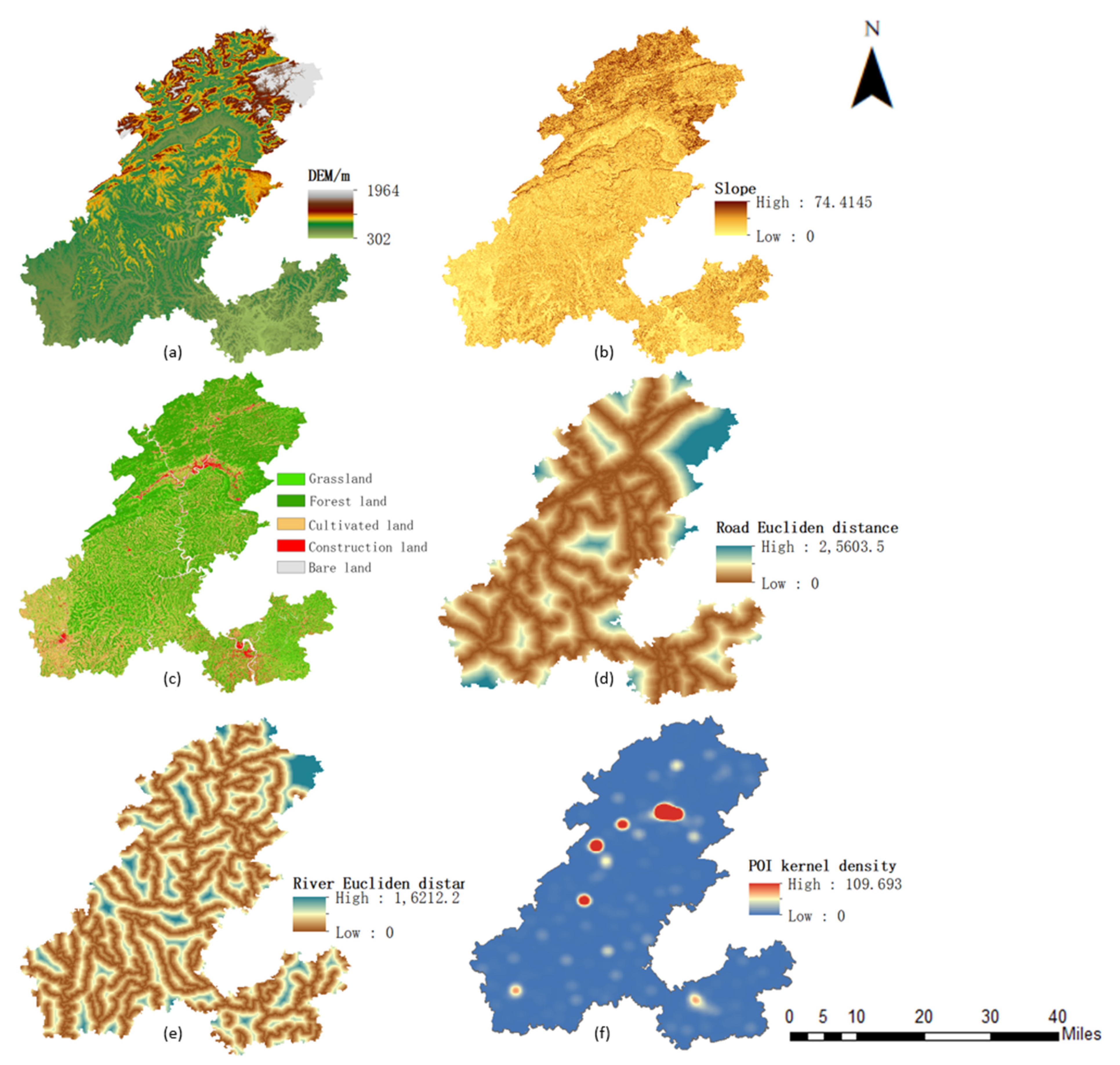
The data on administrative divisions, rivers and roads as well as restaurants, hotels, and scenic areas were downloaded and then manually screened to eliminate duplicates and irrelevant data. The data were imported into ArcGIS and then analyzed for Euclidean distance for its river road data and kernel density for the POI data (as shown in Figure 2).
2.4. Research Methods
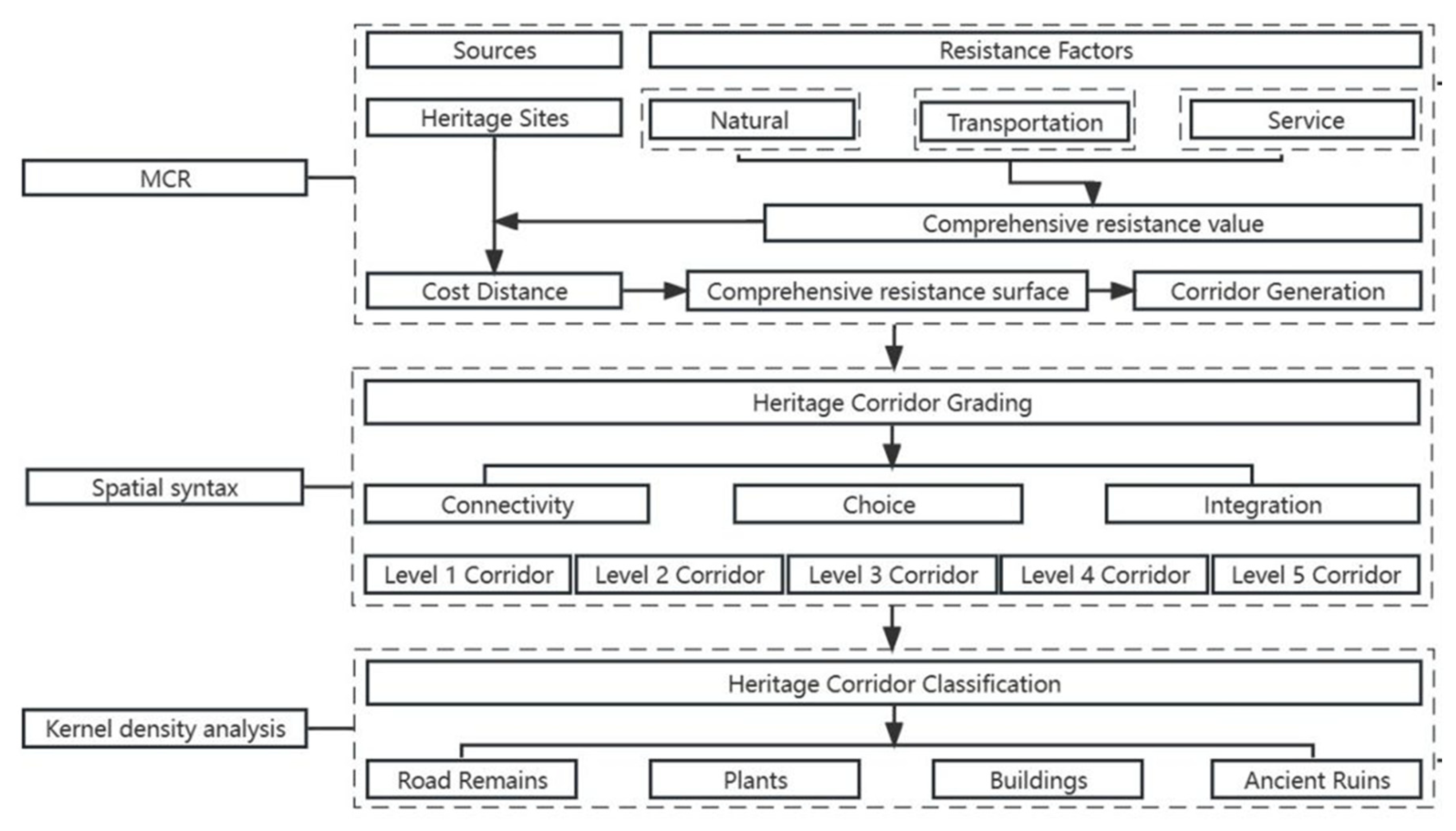
In this paper, the construction of heritage corridors was mainly carried out in three steps: first, the evaluation index system was established, and the least cumulative resistance model was used to generate heritage corridors; second, the spatial syntax analysis was applied, and the connectivity, choice, and integration were selected for the grading of heritage corridors; lastly, heritage corridors were classified by combining with the kernel density analysis method. The research framework of this paper is shown in Figure 3.
2.4.1. Heritage Corridor Generation
The generation of heritage corridors is mainly based on the establishment of a suitability evaluation index system and the use of the minimum cumulative resistance model to simulate the generation of potential heritage corridors.
In this paper, on the basis of reference to existing studies and considering the actual situation of the Shu Road, 12 types of resistance factors constituting a comprehensive resistance surface were determined from three aspects including the natural environment, traffic network, and public services, and the reasons for selecting the above resistance factors are shown in Table 3.
In order to determine the resistance value of each resistance factor, this paper invited experts in the fields of cultural heritage, tourism, geography, ecology, landscape architecture, and other professional fields to score the weights of the resistance factors of the heritage corridor based on the characteristics of the heritage of the Shu Road and the current situation of the ecological environment, determine the weight of each resistance factor after repeated discussion, and to finally construct a system of evaluation indices, as shown in Table 4.
Based on the determination of the suitability evaluation index system, this study adopted the minimum cumulative resistance model for the generation of heritage corridors. Minimum cumulative resistance modeling focuses on simulating the minimum work undertaken or the minimum cumulative cost of passing from a “source” through various types of landscapes with different resistance values. The model was first proposed by the Dutch ecologist Knappen and has been mainly used for the study of species dispersal processes [40]. Yu K et al. introduced the minimum cumulative resistance model into the field of heritage corridors for the first time when discussing a new approach to heritage corridor suitability analysis [41]. The minimum cumulative resistance model simulates the resistance posed by different resistance factors to the process of heritage preservation and recreational experience during the generation of heritage corridors, and heritage corridor suitability is inversely proportional to the magnitude of resistance values. The formula is as follows:
where MCR is the minimum cumulative resistance value; Dij is the spatial distance of the person experiencing from environmental element i to heritage source j; Ri is the resistance value of environmental element i to the spatial movement process of the experience.
Using the minimum cumulative resistance model and ArcGIS spatial analysis method, we constructed a single-factor resistance surface, weighted, and superimposed it to obtain the comprehensive resistance distribution map, then used the cost distance tool in ArcGIS10.7 to calculate and acquire the suitability evaluation of the Shu Road heritage corridor, and divided the study area into five suitability zones: the high suitability zone, middle-high suitability zone, middle suitability zone, middle-low suitability zone, and low suitability zone by using the natural break-point method.
2.4.2. Heritage Corridor Grading
In order to better study heritage corridors, this paper graded heritage corridors, where objective and logical grading is essential for heritage corridors. In this study, spatial syntax analysis was used and connectivity, choice, and integration were selected to classify the heritage corridors.
Space Syntax was proposed by Prof. Bill Hillier to take the spatial organization and human social relations as the research object, and geometric topology as the theoretical basis for analyzing the complex urban network relationship [42]. Connectivity refers to the number of nodes in the space that directly connect to other nodes [43]. The higher the connectivity of a node, the more influence it has on surrounding nodes. Choice is the probability or frequency of the shortest path from a node to other nodes in a spatial system [44]. Nodes with high choice are more important in the spatial network and are more likely to be passed by the crowd. The formula is as follows:
where n indicates the total number of heritage points within the search radius, and ACH indicates the degree of the angular selection of X.
Integration, which refers to the degree of aggregation and dispersion between a node and other nodes in the space, also represents the associativity of the space [45] A region with a high level of integration exhibits better convenience and accessibility. The formula is as follows:
where n indicates the total number of heritage points within the search radius, and dθ(x,i) indicates the angular topological distance between space x and space i.
Based on the above research, this paper categorized the generated heritage corridors into five classes. The higher the grade of the heritage corridor, the greater its connectivity, choice, and integration, and the more accessible, attractive the heritage corridor will be.
2.4.3. Heritage Corridor Classification
In order to analyze the heritage corridors more comprehensively, this study used kernel density analysis to classify the types of heritage corridors. Kernel density analysis was used to calculate the degree of aggregation of spatial elements throughout the study area in order to visualize the degree of aggregation and the dispersion of the spatial distribution of heritage sites. A greater kernel density value f(x) indicates a higher degree of aggregation [46]. The formula is as follows:
where kx − xih is the kernel density formula; h is the search range and h ≠ 0; n is the number of heritage points in the search range; x − xi is the distance from the valuation point x to the measurement point xi, and the density distribution has the highest value at the center of each xi point, decreases continuously outward, and when the distance reaches a certain threshold value h at the center, the density decreases to zero.
In this paper, we selected the appropriate analysis radius for the kernel density analysis according to the four types of road remains, plants, structures, and ancient sites, in order to characterize the degree of aggregation and dispersion of heritage resource sites in the spatial distribution and classify heritage corridors into a total of eight types.
3. Results
3.1. Heritage Corridor Generation
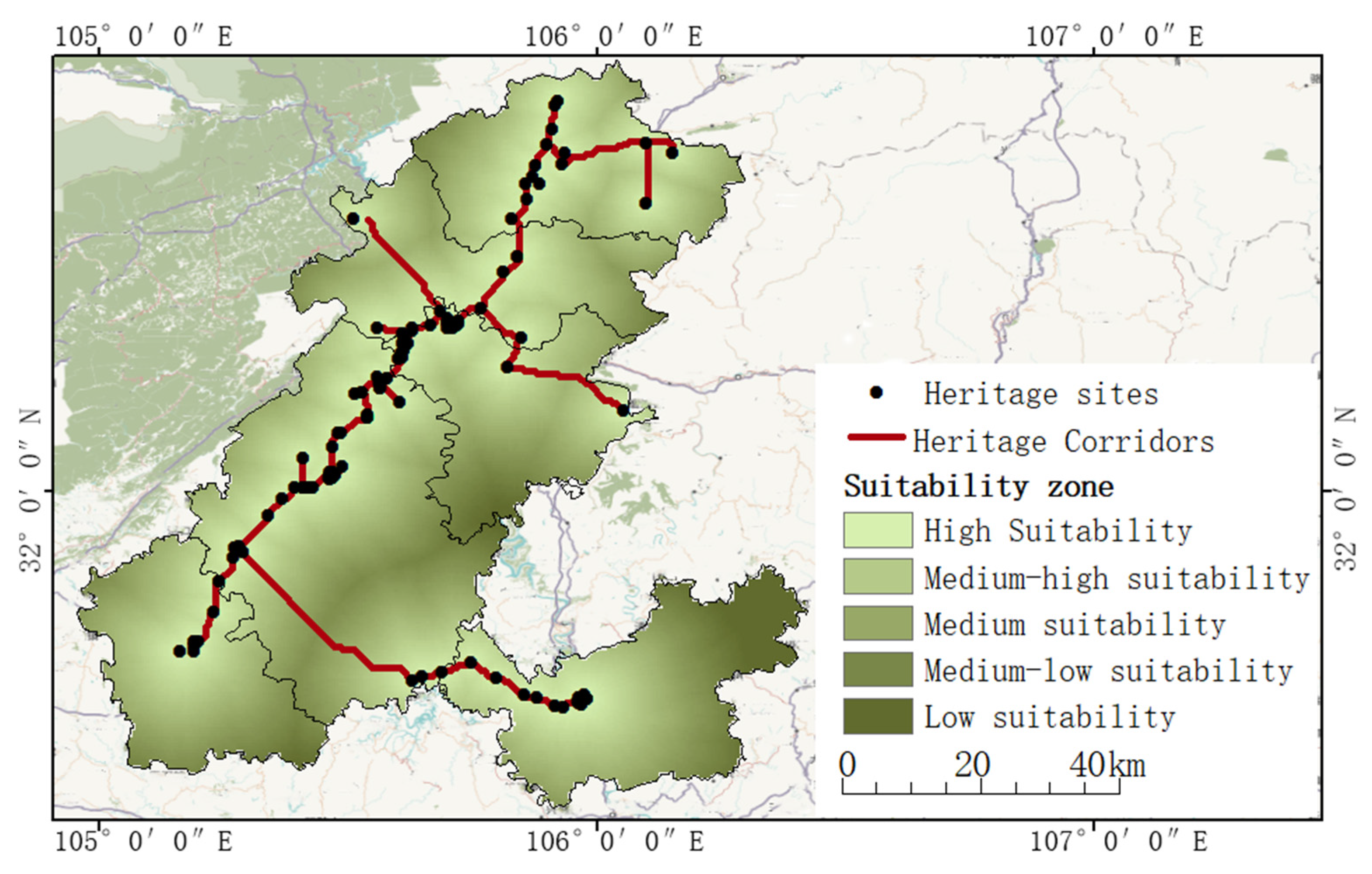
Based on the established heritage corridor generation methodology described above, the results of the potential heritage corridors generated are shown in Figure 4. The medium-high suitability zone shows a distinct linear distribution characteristic, with a total corridor length of 405.625 km, and the corridor is roughly southwest–northeast oriented, showing a non-closed-ring radial shape.
The northern corridors were mainly composed of three branches: the first from Zhahua ancient city to the Daitan at the northern end of the corridors, which was roughly the same direction as the Jialing River due to the undulating terrain; the second started from Mingyue Gorge and passed through the remains of the road to reach Tandu Pass, connecting with the northern Baoxie Road; the third showed an east–west direction, connecting Shuanglong Bridge with the remains of the Xiaoshikou of the road. The central corridors were mainly located in Jiange including the Jianmen Pass military system, the ancient city of Jiange, the Daoist stone statues in Heming Mountain, and numerous bridges. There were two main branches in the south, the first started from the Wulian stage and connected to the Temple of Qiqu Mountain in the south, through which it could enter Deyang to Chengdu. The second one connected Jiange with Langzhong, and this branch roughly followed the same path as the Baixihao River.
3.2. Heritage Corridor Grading
As can be seen from Figure 5a, the degree of connectivity was generally low, and most of the heritage resource sites showed a decentralized distribution, while the areas with a higher degree of connectivity were mostly tourism scenic spots with a large number of heritage resource sites that are concentrated and more maturely developed including the Jianmen Pass, Langzhong Ancient City, Zhaohua Ancient City, and so on.
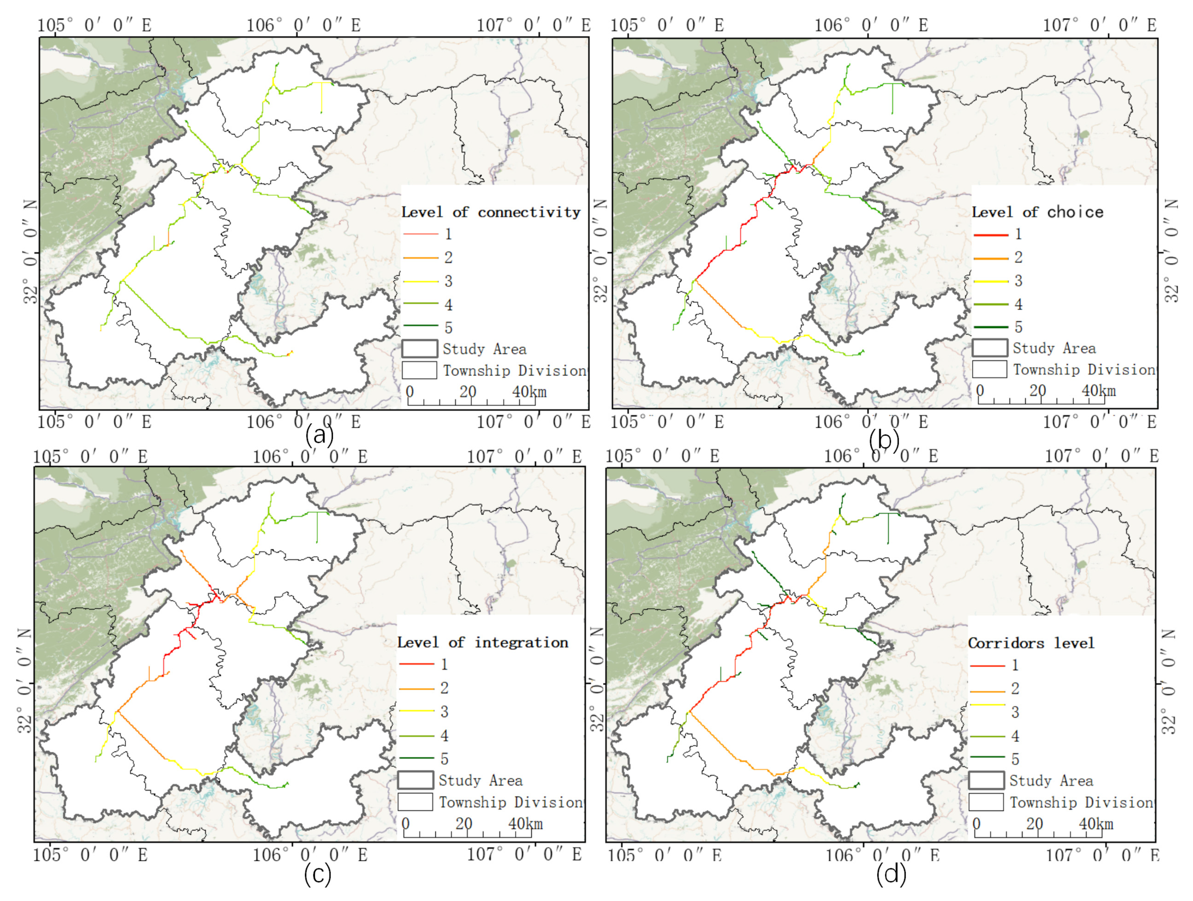
As can be seen from Figure 5b, choice showed an obvious core-edge decreasing distribution pattern, with the highest-value area located in Jiange County and Zhaohua District, where Jiange County and Zhaohua District have a significant advantage in terms of the quantity and quality of the heritage sites, and the area contains the Cuiyun Corridor, Jiange Ancient City, Jianmen Pass, and Zhaohua Ancient City, etc. The second-highest-value area is the corridor connecting Lizhou and Chaotian Districts, and the area is connected to the Mingyue Gorge via Huangze Temple, Thousand Buddha Cliff, and Flying Immortal Pass, etc.
As can be seen in Figure 5c, it can be seen that the corridor integration has formed a more obvious spatial aggregation feature in the middle of the study area, and the integration of the surrounding branches is lower.
As can be seen from Figure 5d, the overall distribution pattern of the heritage corridor grade showed a decreasing pattern from the central high-value area to the surrounding area. The first-level corridor consists of two sections, mainly concentrated in Jiange County, the first section is from Jueyuan Temple to Jianmen Pass, and the second section is from Jianmen Pass to Guanyin Rock, which together with the surrounding branch corridors form a “high-level corridor aggregation area”. The second-level and third-level corridors are mainly the corridors connecting Jiange and Langzhong as well as the corridors in the northern part of Lizhou District and Chaotian District. The fourth and fifth level corridors are mainly located in Zitong County and Chaotian District at the edge of the study area.
3.3. Heritage Corridor Classification
As can be seen in Figure 6, a high-density of road remains was located in Langzhong and Chaotian, while the other areas had a lower nuclear density; the high-density areas of plants were mainly located in Jiange and Zitong, with the Cuiyun Corridor as the main representative; the high-density areas of buildings were found in Zhaohua Ancient City, Jiange Ancient City, and Langzhong Ancient City; ancient ruins are scattered throughout the study area, and there were high-density clusters in Zhaohua District.
3.4. Heritage Corridor Construction
As can be seen from Figure 7 and Table 5, a total of 15 segments of corridors were divided by manual discrimination including two first-level corridors, two second-level corridors, three third-level corridors, four fourth-level corridors, and four fifth-level corridors. On this basis, the 15 sections of the corridor were categorized into eight types: two sections of three composite types, five sections of double composite types, and eight sections of the single type. Corridors located in the central part of the study area are mostly composite high-grade corridors, and the farther away from the center, the lower the grade of the corridor, and mostly single-type corridors such as the first-grade corridors in Jiange County and the first-grade corridors in Zhaohua District are three kinds of composite corridors, and the single-type corridors are concentrated in the fourth- and fifth-grade corridors.
4. Discussion
4.1. Discussion on Research Methodology
The existing research approaches to heritage corridor construction have mostly focused on the generation of heritage corridors, and few studies have focused on the grading and classification of heritage corridors [47,48,49].
This study not only analyzed the generation of heritage corridors, but also focused on the grading and classification of heritage corridors, discussed the construction of the heritage corridor system in depth, and proposed a more systematic and complete construction system of heritage corridors. In the construction of an evaluation index system for heritage corridor generation, existing studies have tended to focus on natural factors [50,51,52] such as elevation, terrain undulation, slope, land use type, and other indicators, while human factors such as road density, public services, and other human activities closely related to the corridor also affect the structural characteristics of the corridor to a certain extent, so this study not only considered the natural environment elements in the selection of resistance factors, but also considered the socio-economic elements to make the evaluation index system more objective. In terms of heritage corridor grading, this paper chose spatial syntax for heritage corridor grading research, as the introduction of spatial syntax can comprehensively analyze the characteristics of the heritage corridor, enabling the grading characteristics of the corridor to achieve visualization, corridor grading protection and development as well as the grading of the configuration of tourism facilities to provide a scientific basis. In terms of heritage corridor classification, this study used kernel density analysis to observe the spatial visualization pattern of elements of heritage sites to obtain the spatial layout and degree of agglomeration and disaggregation of heritage sites in the study area, which increases the scientific process of corridor classification and has a certain value of reference for the conservation strategy, thematic planning, and thematic area delineation of heritage corridors.
Although the results of the heritage corridor construction method obtained based on the minimum cumulative resistance model and spatial syntax and kernel density analysis are reliable, this study still inevitably had some shortcomings. First of all, there was inconsistency in the accuracy between the data of the suitability evaluation index system adopted in the study such as the higher accuracy of the index data obtained based on the interpretation of high spatial resolution remote sensing data and the lower accuracy of the index data obtained based on the National Geographic Information Resources Catalog Service System, which to a certain extent affects the accuracy of the generation of heritage corridors. Secondly, the factors affecting the construction of the Shu Road heritage corridor are complex and variable, and some indicators are difficult to quantify and were therefore not included in the evaluation index system and heritage corridor grading indicators. For example, this study did not consider the impact of the degree of conservation and development of heritage resource sites on the generation and hierarchical classification of heritage corridors. In addition, the application for World Heritage listing of the Shu Road is constantly advancing, and information on the number, location, and chronology of heritage resource sites is being updated and supplemented, so we were not able to comprehensively include heritage resource sites in our study.
The heritage corridor construction system established in this study is an effective method for constructing large-scale cross-regional heritage corridors, so it is applicable to the construction of large-scale cross-regional heritage corridors. Second, this methodology is applicable to other small- and medium-sized heritage corridors. However, it should be noted that the natural environment and socio-economic conditions specific to different regions should be fully taken into account when constructing the resistance surface evaluation index system.
4.2. Strategies for the Protection and Development of the Shu Road Heritage Corridor
The generation of heritage corridors as well as hierarchical classification studies provide a scientific basis for the protection and development of the Shu Road heritage corridors. The generation of heritage corridors connects heritage resource sites and heritage areas, forming a multi-scale heritage protection and development structure of “heritage resource sites–heritage corridors–heritage areas”. The hierarchical classification study of heritage corridors explored the refined spatial structure of heritage corridors with multiple levels and types, and delicately portrays the spatial hierarchy and functionality of corridors, which is of reference value for the protection of heritage corridors, the planning of tourism across the whole region, the organization of tourism routes, and the utilization of heritage as a whole. Based on the above research results as a reference, combined with the current situation of the protection and development of the Shu Road, this study proposes the following protection and development strategies:
The Level 1 corridor is divided into two sections, with the Wulian Station–Jianmen Pass section located in Jiange County. This section, as the area with the highest grade and the richest type of heritage resource points, has advantages in terms of protection and development, with maturely developed scenic spots such as Jianmen Pass, Jiange Ancient City, and Cuiyun Corridor in the area, which includes plants, buildings, ruins, and other types of heritage resource points. In terms of protection, as there are a large number of national and provincial cultural protection units in the region, in the core area of the heritage resource sites following the principle of “protection-oriented”, the protection of cultural relics, display, and archaeological works have been carried out to ensure that the heritage resource sites are protected in a comprehensive and static manner. In terms of development, this section has the national 5A level tourist attraction Jianmen Pass Scenic Spot and the national 4A level tourist attraction Cuiyun Corridor. Relying on the development of mature scenic spots with the theme of heritage sightseeing, it creates a leisure and sightseeing resort area integrating the experience of distinctive transportation, the experience of outdoor extreme sports, and the experience of the ancient Shu Road and the Three Kingdoms culture. The section of Gaomiao Station–Orange Cypress is located in Zhaohua District, and the area is rich in heritage resources, with the ruins of the Zhaohua Ancient City and Stage as the main ones. In terms of protection, Zhaohua Ancient City has a number of provincial-level cultural relic protection units such as Longmen Academy, Yixinyuan, Yihetang, Zhaohua Examination Sheds, and the Bell and Drum Tower Ancient Architecture Area, where these heritage resource points, in accordance with relevant laws and regulations for protection, constantly update the corresponding protection and development charter to improve the construction of the protection system. In terms of development, this section of the heritage corridor should be centered on the Zhaohua Ancient City, with the Shu Road culture as the core and the Three Kingdoms culture as the supplement, in order to build up the theme of cultural experience and leisure in the ancient town, and to combine Tianxiong Pass, Dazhao Station, and other heritage resource points to create the Shu Road theme tourism and leisure area.
The level 2 and 3 corridors are mainly double-composite corridors, connecting a larger number of heritage resource sites and possessing higher conservation and development values. The Jueyuan Temple–Houzi Station section mainly consists of the remains of the road connecting Jiange and Langzhong and the ruins of the post store, of which Jueyuan Temple is a national key cultural relic protection unit. This section of heritage resource sites is mainly implemented in a single-point protection mode, based on the existing corridor, which relies on the beautiful natural landscape of the village combined with the surrounding villages and towns to develop tourism in the Shu Road original township. The Guangyin Rock–Mingyue Gorge section has heritage resource sites such as the Guanyin Rock Carvings, Huangze Temple, Thousand Buddha Cliff, and the Mingyue Gorge. With the section of the Mingyue Gorge as the core, and the ancient palisades and canyon landscape as the characteristics of the development of the Mingyue Gorge scenic area while at the same time relying on the Thousand Buddha Cliff, Huangze Temple, and other development of the Queen’s hometown regarding the humanities scenic area, this section will be created for the Shu Road cultural enlightenment routes and recreational and vacation routes.
Level 4 and 5 corridors are mainly low-grade corridors of a single type. Under the principle of “protection-oriented and rational utilization”, important heritage resource sites on the corridors will be protected and repaired, and under the condition of satisfying the protection of the heritage resource sites, the construction of tourism infrastructures will be improved, and leisure and tourism projects related to their themes will be developed. Road-based heritage corridors should be protected and repaired on the basis of their remaining roads, setting up hiking, cycling, and other experiences, restoring the important post stations and pavilions along the roads as well as the commercial and postal service system of the Shu Road, and reproducing the prosperity of the ancient Shu Road. For corridors that are dominated by ruins, the main strategy is to implement monolithic protection, restore important ruins, thoroughly excavate the historical stories of the ruins, improve the interpretation system of the ruins, avoid excessive development and utilization, and carry out regular inspections and repairs.
5. Conclusions
This study mainly focused on the heritage corridor construction system for the Shu Road with the support of ArcGIS and used the minimum cumulative resistance model, spatial syntax, and kernel density analysis to construct the heritage corridor. Through the whole study, we can obtain the following conclusions:
Heritage corridors show highly concentrated non-closed-loop radial distribution characteristics; heritage corridors have multi-center features that show a core-edge attenuation distribution pattern. Based on the natural discontinuity method, the corridor can be divided into five levels, where the heritage corridor grade shows the center of the high, surrounded by the low distribution characteristics. Heritage corridors can be divided into eight types; the corridors located in the center of the study area are multi-complex high-grade corridors, whereas farther away from the center of the corridors, the corridor grade is lower, and most of them are mono-functional corridors. It can be seen that this paper used the minimum cumulative resistance model to generate heritage corridors, adopted the spatial sentence method to assess the corridor centrality characteristics for corridor classification, and combined the kernel density analysis method to form the corridor classification scheme, which together constitute a systematic and comprehensive heritage corridor construction system. The study confirmed that the minimum cumulative resistance model, from a regional perspective, combined with spatial syntax and kernel density analysis, provides a new research idea for the conservation and sustainable development of this type of trans-regional linear cultural heritage, and guides the conservation and development work related to heritage corridors. In the next step of the study, we will supplement the information on the quantity, location, and date of the heritage resource points according to the inscription of the Shu Road, and at the same time, we will consider how to incorporate the information on the protection status of the heritage resource points into the evaluation index system to further improve the methodology of constructing the heritage corridor system proposed in this paper.
Author Contributions
Conceptualization, X.L.; Methodology, F.Y.; Software, F.Y.; Data curation, D.L.; Writing—original draft preparation, F.Y.; Writing—review and editing, X.L.; Visualization, Q.H.; Supervision, X.L. All authors have read and agreed to the published version of the manuscript.
Funding
This work funded by the Chengdu University of Technology “Double First-Class” initiative Construction Philosophy and Social Sciences Key Construction Project (ZDJS202217).
Data Availability Statement
The data presented in this study are available on request from the corresponding author.
Acknowledgments
We thank the reviewers for scrutinizing the manuscript with their insight. We are grateful to the experts who provided us with advice and input in determining the resistance factor.
Conflicts of Interest
The authors declare no conflict of interest.
References
- Chen, Y.; Dang, A.; Peng, X. Building a cultural heritage corridors based on geodesign theory and methodology. J. Urban Manag. 2014, 3, 97–112. [Google Scholar] [CrossRef]
- Ji, X.; Shao, L. The Application of Landscape Infrastructure Approaches in the Planning of Heritage Corridors Supporting System. Procedia Eng. 2017, 198, 1123–1127. [Google Scholar] [CrossRef]
- Searns, R.M. The evolution of greenways as an adaptive urban landscape form. Landsc. Urban Plan. 1995, 33, 65–80. [Google Scholar] [CrossRef]
- Ahern, J. Greenways as a planning strategy. Landsc. Urban Plan. 1995, 33, 131–155. [Google Scholar] [CrossRef]
- Zou, T.; Hao, Y.; Jiang, L.; Xue, B. Identifying Brand Genes in Tourism Branding Strategy: A Case Study of “Chang’an-Tianshan” Heritage Corridors. In Proceedings of the International Conference Proceedings: Heritage Tourism & Hospitality 2015, Amsterdam, The Netherlands, 26–27 November 2015; pp. 211–222. [Google Scholar]
- Li, H.; Jing, J.; Fan, H.; Li, Y.; Liu, Y.; Ren, J. Identifying cultural heritage corridors for preservation through multidimensional network connectivity analysis—A case study of the ancient Tea-Horse Road in Simao, China. Landsc. Res. 2021, 46, 96–115. [Google Scholar] [CrossRef]
- Zhang, S.; Liu, J.; Pei, T.; Chan, C.-S.; Wang, M.; Meng, B. Tourism value assessment of linear cultural heritage: The case of the Beijing–Hangzhou Grand Canal in China. Curr. Issues Tour. 2023, 26, 47–69. [Google Scholar] [CrossRef]
- Shishmanova, M.V. Cultural tourism in cultural corridors, itineraries, areas and cores networked. Procedia-Soc. Behav. Sci. 2015, 188, 246–254. [Google Scholar] [CrossRef]
- Zhang, D.Q.; Shao, W.W.; Feng, T.Q. Discussion on Construction of the Weihe River System Heritage Corridors in Xi’an Metropolitan Area. Appl. Mech. Mater. 2014, 641, 531–536. [Google Scholar] [CrossRef]
- Kashid, M.; Ghosh, S.; Narkhede, P. A Conceptual Model for Heritage Tourism Corridors in the Marathwada Region. In Proceedings of the National Online Conference on Planning, Design and Management, Pune, India, 6–7 May 2022. [Google Scholar]
- Hui, C.; Dong, C.; Yuan, Z.; Sicheng, M. Construction of corridors of architectural heritage along the line of ZiJiang River in Hunan Province in the background of the Tea Road Ceremony. In IOP Conference Series: Materials Science and Engineering; IOP Publishing: Bristol, UK, 2019; Volume 471, p. 082024. [Google Scholar]
- Li, H.; Duan, Q.; Zeng, Z.; Tan, X.; Li, G. Value Evaluation and Analysis of Space Characteristics on Linear Cultural Heritage Corridors Ancient Puer Tea Horse Road. In Proceedings of the Geo-Informatics in Resource Management and Sustainable Ecosystem: Third International Conference, GRMSE 2015, Wuhan, China, 16–18 October 2015; Revised Selected Papers 3. Springer: Berlin/Heidelberg, Germany, 2016; pp. 733–740. [Google Scholar]
- Morandi, D.T.; de Jesus França, L.C.; Menezes, E.S.; Machado, E.L.M.; da Silva, M.D.; Mucida, D.P. Delimitation of ecological corridors between conservation units in the Brazilian Cerrado using a GIS and AHP approach. Ecol. Indic. 2020, 115, 106440. [Google Scholar] [CrossRef]
- Lin, F.; Zhang, X.; Ma, Z.; Zhang, Y. Spatial Structure and Corridors Construction of Intangible Cultural Heritage: A Case Study of the Ming Great Wall. Land 2022, 11, 1478. [Google Scholar] [CrossRef]
- Li, Y.; Wang, X.; Dong, X. Delineating an integrated ecological and cultural corridors network: A case study in Beijing, China. Sustainability 2021, 13, 412. [Google Scholar] [CrossRef]
- Zhang, L.; Peng, J.; Liu, Y.; Wu, J. Coupling ecosystem services supply and human ecological demand to identify landscape ecological security pattern: A case study in Beijing–Tianjin–Hebei region, China. Urban Ecosyst. 2017, 20, 701–714. [Google Scholar] [CrossRef]
- Ye, H.; Yang, Z.; Xu, X. Ecological corridors analysis based on MSPA and MCR model—A case study of the Tomur World Natural Heritage Region. Sustainability 2020, 12, 959. [Google Scholar] [CrossRef]
- Li, F.; Ye, Y.; Song, B.; Wang, R. Evaluation of urban suitable ecological land based on the minimum cumulative resistance model: A case study from Changzhou, China. Ecol. Model. 2015, 318, 194–203. [Google Scholar] [CrossRef]
- Jiang, W.; Cai, Y.; Tian, J. The application of minimum cumulative resistance model in the evaluation of urban ecological land use efficiency. Arab. J. Geosci. 2019, 12, 714. [Google Scholar] [CrossRef]
- Huang, L.; Wang, D.; He, C. Ecological security assessment and ecological pattern optimization for Lhasa city (Tibet) based on the minimum cumulative resistance model. Environ. Sci. Pollut. Res. 2022, 29, 83437–83451. [Google Scholar] [CrossRef]
- Tang, F.; Zhang, P.T.; Zhang, G.J.; Zhao, L.; Zheng, Y.; Wei, M.H.; Jian, Q. Construction of ecological corridors in Changli County based on ecological sensitivity and ecosystem service values. J. Appl. Ecol. 2018, 29, 2675–2684. [Google Scholar]
- Li, P.; Cao, H.; Sun, W.; Chen, X. Quantitative evaluation of the rebuilding costs of ecological corridors in a highly urbanized city: The perspective of land use adjustment. Ecol. Indic. 2022, 141, 109130. [Google Scholar] [CrossRef]
- Wei, Z.; Xu, Z.; Dong, B.; Xu, H.; Lu, Z.; Liu, X. Habitat suitability evaluation and ecological corridors construction of wintering cranes in Poyang Lake. Ecol. Eng. 2023, 189, 106894. [Google Scholar] [CrossRef]
- Peng, J.; Zhao, H.; Liu, Y. Urban ecological corridors construction: A review. Acta Ecol. Sin. 2017, 37, 23–30. [Google Scholar] [CrossRef]
- Rodríguez-Espinosa, V.M.; Aguilera-Benavente, F.; Gómez-Delgado, M. Green infrastructure design using GIS and spatial analysis: A proposal for the Henares Corridors (Madrid-Guadalajara, Spain). Landsc. Res. 2020, 45, 26–43. [Google Scholar] [CrossRef]
- Pascual-Hortal, L.; Saura, S. Comparison and development of new graph-based landscape connectivity indices: Towards the priorization of habitat patches and corridors for conservation. Landsc. Ecol. 2006, 21, 959–967. [Google Scholar] [CrossRef]
- Guo, X.; Zhang, X.; Du, S.; Li, C.; Siu, Y.L.; Rong, Y.; Yang, H. The impact of onshore wind power projects on ecological corridors and landscape connectivity in Shanxi, China. J. Clean. Prod. 2020, 254, 120075. [Google Scholar] [CrossRef]
- Xiao, S.; Wu, W.; Guo, J.; Ou, M.; Pueppke, S.G.; Ou, W.; Tao, Y. An evaluation framework for designing ecological security patterns and prioritizing ecological corridors: Application in Jiangsu Province, China. Landsc. Ecol. 2020, 35, 2517–2534. [Google Scholar] [CrossRef]
- Xiao, Y.; Xiao, Y. Space Syntax Methodology Review. In Urban Morphology and Housing Market; Springer: Berlin/Heidelberg, Germany, 2017; pp. 41–61. [Google Scholar]
- Jiang, B.; Claramunt, C.; Klarqvist, B. Integration of space syntax into GIS for modelling urban spaces. Int. J. Appl. Earth Obs. Geoinf. 2000, 2, 161–171. [Google Scholar] [CrossRef]
- Alkamali, N.; Alhadhrami, N.; Alalouch, C. Muscat City expansion and Accessibility to the historical core: Space syntax analysis. Energy Procedia 2017, 115, 480–486. [Google Scholar] [CrossRef]
- Karimi, K. A configurational approach to analytical urban design: ‘Space syntax’ methodology. Urban Des. Int. 2012, 17, 297–318. [Google Scholar] [CrossRef]
- Atakara, C.; Allahmoradi, M. Investigating the urban spatial growth by using space syntax and GIS—A case study of Famagusta city. ISPRS Int. J. Geo-Inf. 2021, 10, 638. [Google Scholar] [CrossRef]
- Dursun, P. Space syntax in architectural design. In Proceedings of the 6th International Space Syntax Symposium, Istanbul, Turkey, 12–15 June 2007; pp. 1–56. [Google Scholar]
- Alitajer, S.; Nojoumi, G.M. Privacy at home: Analysis of behavioral patterns in the spatial configuration of traditional and modern houses in the city of Hamedan based on the notion of space syntax. Front. Archit. Res. 2016, 5, 341–352. [Google Scholar] [CrossRef]
- Li, W.; Chen, M.; Yao, N.; Luo, Z.; Jiao, Y. Spatial-temporal evolution of roadway layout system from a space syntax perspective. Tunn. Undergr. Space Technol. 2023, 135, 105038. [Google Scholar] [CrossRef]
- Law, S.; Chiaradia, A.; Schwander, C. Towards a multimodal space syntax analysis: A case study of the London street and underground network. In Proceedings of the 8th International Space Syntax Symposium, Santiago de Chile, Chile, 3–6 January 2012; p. 36. [Google Scholar]
- Yu, W.; Ai, T.; Shao, S. The analysis and delimitation of Central Business District using network kernel density estimation. J. Transp. Geogr. 2015, 45, 32–47. [Google Scholar] [CrossRef]
- Zhang, J.; Cenci, J.; Becue, V.; Koutra, S. Analysis of spatial structure and influencing factors of the distribution of national industrial heritage sites in China based on mathematical calculations. Environ. Sci. Pollut. Res. 2022, 29, 27124–27139. [Google Scholar] [CrossRef] [PubMed]
- Qiu, S.; Fang, M.; Yu, Q.; Niu, T.; Liu, H.; Wang, F.; Xu, C.; Ai, M.; Zhang, J. Study of spatialtemporal changes in Chinese forest eco-space and optimization strategies for enhancing carbon sequestration capacity through ecological spatial network theory. Sci. Total Environ. 2023, 859, 160035. (In Chinese) [Google Scholar] [CrossRef] [PubMed]
- Yu, K.; Li, W.; Li, D. Suitability analysis of heritage corridor in rapidly urbanizing region: A case study of Taizhou city. Geogr. Res. 2005, 24, 69–76+162. (In Chinese) [Google Scholar]
- Dong, Y.; Jiang, Y.; Quan, D.; Zhu, H. Study on the heritage corridors construction of the western han dynasty mausoleums region. Curr. Urban Stud. 2022, 10, 55–72. (In Chinese) [Google Scholar] [CrossRef]
- Hillier, B.; Leaman, A.; Stansall, P.; Bedford, M. Space syntax. Environ. Plan. B Plan. Des. 1976, 3, 147–185. [Google Scholar] [CrossRef]
- Bafna, S. Space syntax: A brief introduction to its logic and analytical techniques. Environ. Behav. 2003, 35, 17–29. [Google Scholar] [CrossRef]
- Li, Y.; Xiao, L.; Ye, Y.; Xu, W.; Law, A. Understanding tourist space at a historic site through space syntax analysis: The case of Gulangyu, China. Tour. Manag. 2016, 52, 30–43. (In Chinese) [Google Scholar] [CrossRef]
- Hillier, B. Network effects and psychological effects: A theory of urban movement. In Proceedings of the 5th International Space Syntax Symposium, Delft, The Netherlands, 13–17 June 2005. [Google Scholar]
- Wang, Y.; Zeng, G. Research on the construction of the Silk Road Cultural Heritage Corridor form the spatial perspective-A case of Gansu section. World Reg. Stud. 2022, 31, 862–871. (In Chinese) [Google Scholar]
- Yang, X.; Chen, J. Construction of linear intangible cultural heritage corridor along the Chinese section of the “Silk Road Economic Belt”. J. Arid Land Resour. Environ. 2021, 35, 202–208. (In Chinese) [Google Scholar]
- Li, H.; Wang, Z. Study on the Anti-Japanese Heritage Corridor System based on GIS Spatial Analysis: A case of Main Urban Area in Chongqing. Urban Dev. Stud. 2017, 24, 86–93. (In Chinese) [Google Scholar]
- Ten, Y. Xiaohe Ancient Road Heritage Corridor Construction Based on Minimum Cumulative Resistance Model. Planners 2020, 36, 66–70. (In Chinese) [Google Scholar]
- Yuan, Y.; Xu, J.; Zhang, X. Construction of Heritage Corridor Network Based on Suitability Analysis: A case Study of the Ancient Capital of Luoyang. Remote Sens. Inf. 2014, 29, 117–124. (In Chinese) [Google Scholar]
- Wang, S.; Li, T.; Dong, Y. Spatial structure heritages and establishment of heritage corridor network in Beijing. J. Arid Land Resour. Environ. 2010, 24, 51–56. (In Chinese) [Google Scholar]
Figure 1.
Study area. (a) Location of the study area in Sichuan Province. (b) Overview of the study area.
Figure 1.
Study area. (a) Location of the study area in Sichuan Province. (b) Overview of the study area.

Figure 2.
Processing of data. (a) Elevation analysis of the study area. (b) Slope analysis of the study area. (c) Analysis of land use types in the study area. (d) Euclidean distance analysis of rivers in the study area. (e) Euclidean distance analysis of roads in the study area. (f) Kernel density analysis of POI in the study area.

Figure 3.
Research framework.

Figure 4.
Partition of the suitability of the heritage corridors.

Figure 5.
Level analysis of the heritage corridors. (a) Connectivity of the heritage corridors; (b) choice of the heritage corridors; (c) integration of the heritage corridors; (d) level of the heritage corridors.
Figure 5.
Level analysis of the heritage corridors. (a) Connectivity of the heritage corridors; (b) choice of the heritage corridors; (c) integration of the heritage corridors; (d) level of the heritage corridors.

Figure 6.
Relationship between heritage kernel density and corridor grade. (a) Relationship between the kernel density of buildings and corridor grade; (b) relationship between kernel density of ancient ruins and corridor grade; (c) relationship between the kernel density of road remains and corridor grade; (d) relationship between the kernel density of plants and corridor grade.

Figure 7.
Classification of heritage corridors. Note: The corridor’s name corresponding to the corridor’s serial number is shown in Table 4. The numbers with circles indicate the serial numbers of the corridor.
Figure 7.
Classification of heritage corridors. Note: The corridor’s name corresponding to the corridor’s serial number is shown in Table 4. The numbers with circles indicate the serial numbers of the corridor.


Table 1.
Heritage resources and resource dating of the Shu Road.
| Types | Historic Sites |
|---|---|
| Road remains | Qingfeng Gorge, Mingyue Gorge1, Mingyue Gorge (Pre Qin Dynasty); Datan Section1, Datan Section2, Jiange Section (The Spring and Autumn Period and the Warring States Period); SantanGou, Longdongbei1, Longdongbei2, Jie Cypress Crossing, Temple of Qiqu mountain Section, Xiaoshikou Section, Houzi Station Section, Songlintang Section1, Songlintang Section2, Mulintang Section, Xiangjiatang Section1, Xiangjiatang Section2 (data deficiencies) |
| Plants | Huang Cypress, Jiange Cypress, King of Cypress (Qin Dynasty); Hanzhuan Cypress, Adou Cypress, Zhuangyuan Cypress, Tangchang Cypress, Huaitai Cypress, Guest-Greeting Pine, Fuqi Cypress, Zhuxiang Cypress, Jin Cypress (Three Kingdoms) |
| Buildings | Qiaogouli Bridge, Xiaohe Bridge, Shidonggou Beacon Tower, Shiban Street, Wuhou Bridge, Guangji Bridge (data deficiencies); Jiameng Pass (Qin and Han Dynasties); Xiaojian City Ruins, Jianhua Beacon Tower (Han Dynasty); Yingpan Ruins, Wugong Bridge (Three Kingdoms); Temple of Qiqu Mountain (Jin Dynasty); Jueyuan Temple, Huaguang Tower, Huangze Temple (Tang Dynasty); Kuzhu Village Ruins (Song Dynasty); Tianxiong Pass, Chaotian Pass (Yuan Dynasty); Xinmin Station Bridge, Jianzhou Confucius Temple, Shitaya Bridge, Jianmen Pass, Well of Eight Diagrams, South Gate and Arrow Tower, Bell Tower and Drum Tower, Ancient City Wall, Zhangheng Ancestral Temple, Dazhao Station (Ming Dynasty); Shuanglong Bridge, Tieshuanzi Bridge, Guafu Bridge, Songning Bridge, Jianxi Bridge, Qingliang Bridge, Shuigouwan Bridge, Zhahua Ancient Town Gate, Longmen Academy, Yihetang, Yixin Garden, Zhaohua Kaopeng, Jia Courtyard, Gu Courtyard, Zhang Courtyard, Jianshan Academy, Erxian Ancestral temple, Langzhong Confucius Temple, Baba Temple, Examination Hall, Guanyin Temple, Mosque, Jianzhou White Tower (Qing Dynasty); Zhaohua Yue Tower (the Republic of China) |
| Ancient ruins | Choubi Stage, Chaoshou Station, Shangting Station, Yanwu Station, Horse blocking wall, Ganchangya, Xin Station, Qipan Pass, Tangfangwan, Zhuyazi, Jiaxiandian, Houzi Station, Guaner Station, Zhaohua Pavilion Ruins, Wulian Stage, Tandu Pass, Baiyang Plank path, Horsepond (data deficiencies); Baiyanba Western Zhou City Ruins (Shang Dynasty); Shangxin Station, Gaomiao Station (Qin and Han Dynasties); Baosanniang Tomb, Jiangwei Tomb, Feiyi Tomb, Jiangewei (Three Kingdoms); Qianfo Ya (Thousand Buddha Cliff) (Wei Dynasty); Guanyin Rock, Heming Mountain Taoism Stone Carving, Baiwei Mountain, Wangyun Stage (Tang Dynasty); Liangshan Station, Shangxin Station, Chuiquan Station (Song Dynasty); Jiaochangba Ancient Architectural Complex, Songxian Pavilion, Jianzhou Pavilion Ruins, Jingu Stage (Qing Dynasty) |
Table 2.
Confusion matrix for the classification of land use types.
| Land Use Type | Number of Pixels | Producer’s Accuracy/% | ||||||
|---|---|---|---|---|---|---|---|---|
| Grassland | Forest Land | Cultivated Land | Construction Land | Bare Land | Other Land | Total | ||
| Grassland | 7 | 2 | 3 | 0 | 0 | 0 | 12 | 70.00 |
| Forest land | 1 | 30 | 0 | 0 | 0 | 0 | 31 | 93.75 |
| Cultivated land | 1 | 0 | 22 | 3 | 1 | 0 | 27 | 81.48 |
| Construction land | 0 | 0 | 0 | 22 | 3 | 0 | 25 | 78.57 |
| Bare land | 1 | 0 | 1 | 3 | 14 | 0 | 19 | 77.78 |
| Other land | 0 | 0 | 1 | 0 | 0 | 26 | 27 | 100 |
| Total | 10 | 32 | 27 | 28 | 18 | 26 | 140 | |
| Producer’s accuracy/% | 58.33 | 96.77 | 81.48 | 88.00 | 73.68 | 96.30 | ||
Table 3.
Indicator system for evaluating the suitability of heritage corridors.
| Resistance Factor | Resistance Factor Selection Basis | Access Time |
|---|---|---|
| Elevation and Slope | Elevation and slope are the basic geomorphological indicators, and the mountains and valleys are the natural skeleton of the heritage corridor. At the same time, the undulating changes of the land surface make the construction of the heritage corridor, the linking of the heritage resource sites, and the accessibility of the corridor more difficult. In the study area, the topography varies greatly, so the elevation and slope have an important influence on the suitability of the construction of heritage corridors. | Calculated from a digital elevation model (DEM) with a spatial resolution of 30 m. |
| Land use type | The land use type in part affects the orientation and ease of construction of heritage corridors. Areas that are more accessible to human activities such as construction land are more suitable for heritage corridors, while types of land such as cultivated land, forested land, and bare land can be more resistant to the construction of heritage corridors. | Land use data from 2022 Sentinel-2 imagery from the Google Earth Engine (GEE) platform with a product level of L2A. |
| Rivers | The most important role of rivers in the construction of heritage corridors is to serve as natural environmental elements linking heritage resource sites, enhancing the excellent landscape value of the heritage corridors, and improving the accessibility of the heritage corridors. The study area has rivers such as the Jialing River, and the ancient Shu Road built the Mingyue Gorge trestle as well as the Orange Cypress Ferry and so on based on the rivers during the construction period. Therefore, this paper selected the distance from the river as an indicator factor to measure whether the river system has a significant connecting effect on the heritage corridor. | River data derived from the National Geographic Information Resources Catalog Service System 2021 1:1 million basic geographic information data. |
| Railroads and Highways | Roads are an important part of the settlement, an important skeleton connecting heritage resource sites and affecting the distribution of heritage resource sites, while road traffic also reflects the accessibility of heritage corridors. Thus, in this paper, railroads, highways, and first, second, and third class national roads were selected as indicators to reflect the influence of road transportation networks on the construction of heritage corridors. | Road data derived from the National Geographic Information Resources Catalog Service System 2021 1:1 million basic geographic information data. |
| Dining spots, Hotels and Scenic spots | The degree of infrastructure will affect the tourism value of the heritage corridor and its attractiveness to tourists, so this paper screened three indicators: restaurants, hotels, and scenic areas. Dining spots and hotels provide convenience for tourists to visit, eat, and stay in the area, and the number of scenic spots reflects to some extent the level of tourism development in the study area. | Dining spot, hotels scenic spot data obtained from Baidu Maps Platform in 2022. |
Table 4.
Heritage corridor resistance factors and their weights and relative resistance values.
| Resistance Factor | Weight | Resistance Value | ||||
|---|---|---|---|---|---|---|
| 1 | 2 | 3 | 4 | 5 | ||
| Elevation/m | 0.1 | 0~500 | 500~700 | 700~900 | 900~1200 | >1200 |
| Slope/° | 0.15 | 5 | 5~10 | 10~15 | 15~25 | >25 |
| Land use type | 0.23 | Construction land | Grassland | Forest land | Cultivated land | Bare land |
| Distance from the river/km | 0.15 | 0~0.5 | 0.5~1 | 1~2 | 2~3 | >3 |
| Distance from the railroad/km | 0.08 | 0~0.5 | 0.5~1 | 1~3 | 3~5 | >5 |
| Distance from the highway/km | 0.07 | 0~0.5 | 0.5~1 | 1~3 | 3~5 | >5 |
| Distance from the primary road/km | 0.05 | 0~0.5 | 0.5~1 | 1 ~3 | 3~5 | >5 |
| Distance from the secondary road/km | 0.03 | 0~0.5 | 0.5~1 | 1~3 | 3~5 | >5 |
| Distance from the tertiary road/km | 0.01 | 0~0.5 | 0.5~1 | 1~3 | 3~5 | >5 |
| Dining locations | 0.05 | 30 | 10~30 | 3~10 | 0.1~3 | 0~0.1 |
| Hotels | 0.05 | 10 | 5~10 | 2~5 | 0.1~2 | 0~0.1 |
| Scenic spots | 0.03 | 8 | 5~8 | 2~5 | 0.1~2 | 0~0.1 |
Table 5.
Grade and type characteristics of the porcelain heritage corridors.
| No. | Name of Corridors | Level | Type |
|---|---|---|---|
| 1 | Wulian Stage—Jiameng Pass | 1 | Plants—Buildings—Ruins |
| 2 | Gaomiao Station—Jie Cypress | 1 | Roads—Buildings—Ruins |
| 3 | Jueyuan Temple—Houzi Station | 2 | Roads—Ruins |
| 4 | Xiaohe Bridge—Songlintang Section | 3 | Roads—Buildings |
| 5 | Songlintang—Guanyin Temple | 4 | Roads—Buildings |
| 6 | Wugong Bridge—Temple of Qiqu Mountain | 4 | Plants—Ruins |
| 7 | Guanyin Rock—Jingu Stage | 3 | Ruins |
| 8 | Jingu Stage—Meiling Pass | 4 | Ruins |
| 9 | Meiling Pass—Shuanglong Bridge | 5 | Buildings |
| 10 | Baosanniang Tomb—Xiaoshikou | 5 | Roads |
| 11 | Guanyin Rock—Mingyue Gorge | 2 | Roads—Ruins |
| 12 | Mingyue Gorge—Qingfeng Gorge | 3 | Roads |
| 13 | Qingfeng Gorge—Datan | 5 | Roads |
| 14 | Qingfeng Gorge—Longdongbei | 4 | Roads |
| 15 | Qipan Pass—Baiyang Plank path | 5 | Ruins |
Disclaimer/Publisher’s Note: The statements, opinions and data contained in all publications are solely those of the individual author(s) and contributor(s) and not of MDPI and/or the editor(s). MDPI and/or the editor(s) disclaim responsibility for any injury to people or property resulting from any ideas, methods, instructions or products referred to in the content. |
© 2023 by the authors. Licensee MDPI, Basel, Switzerland. This article is an open access article distributed under the terms and conditions of the Creative Commons Attribution (CC BY) license (https://creativecommons.org/licenses/by/4.0/).
Share and Cite
MDPI and ACS Style
Yue, F.; Li, X.; Huang, Q.; Li, D. A Framework for the Construction of a Heritage Corridor System: A Case Study of the Shu Road in China. Remote Sens. 2023, 15, 4650. https://doi.org/10.3390/rs15194650
AMA Style
Yue F, Li X, Huang Q, Li D. A Framework for the Construction of a Heritage Corridor System: A Case Study of the Shu Road in China. Remote Sensing. 2023; 15(19):4650. https://doi.org/10.3390/rs15194650
Chicago/Turabian StyleYue, Fengting, Xiaoqin Li, Qian Huang, and Dan Li. 2023. "A Framework for the Construction of a Heritage Corridor System: A Case Study of the Shu Road in China" Remote Sensing 15, no. 19: 4650. https://doi.org/10.3390/rs15194650
Note that from the first issue of 2016, this journal uses article numbers instead of page numbers. See further details here.