
Advancing Skyborne Technologies and High-Resolution Satellites for Pasture Monitoring and Improved Management: A Review
 and
and
Abstract
:
1. Introduction
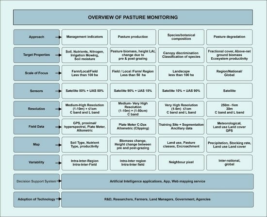
2. Methods
- The geographical location/site of a study.
- The type of sensor used (i.e., optical, multispectral, hyperspectral, SAR).
- Whether a single sensor was used or a combination of sensors together (i.e., fusion).
- The scale with which pasture was monitored (i.e., ≤5 ha, ≥10 ha, ≤50 ha and ≥100 ha);
- The approach for retrieving vegetation parameters for estimating pasture indicators and how this was validated. Information on the adoption of remote sensing approaches by end users.
- Whether environmental (climate and anthropogenic) variables and machine learning were considered.
3. Results
3.1. Spatial and Temporal Dimensions of Reviewed Papers
3.2. Remotely Sensed Environmental Parameters Applied to Pasture Monitoring
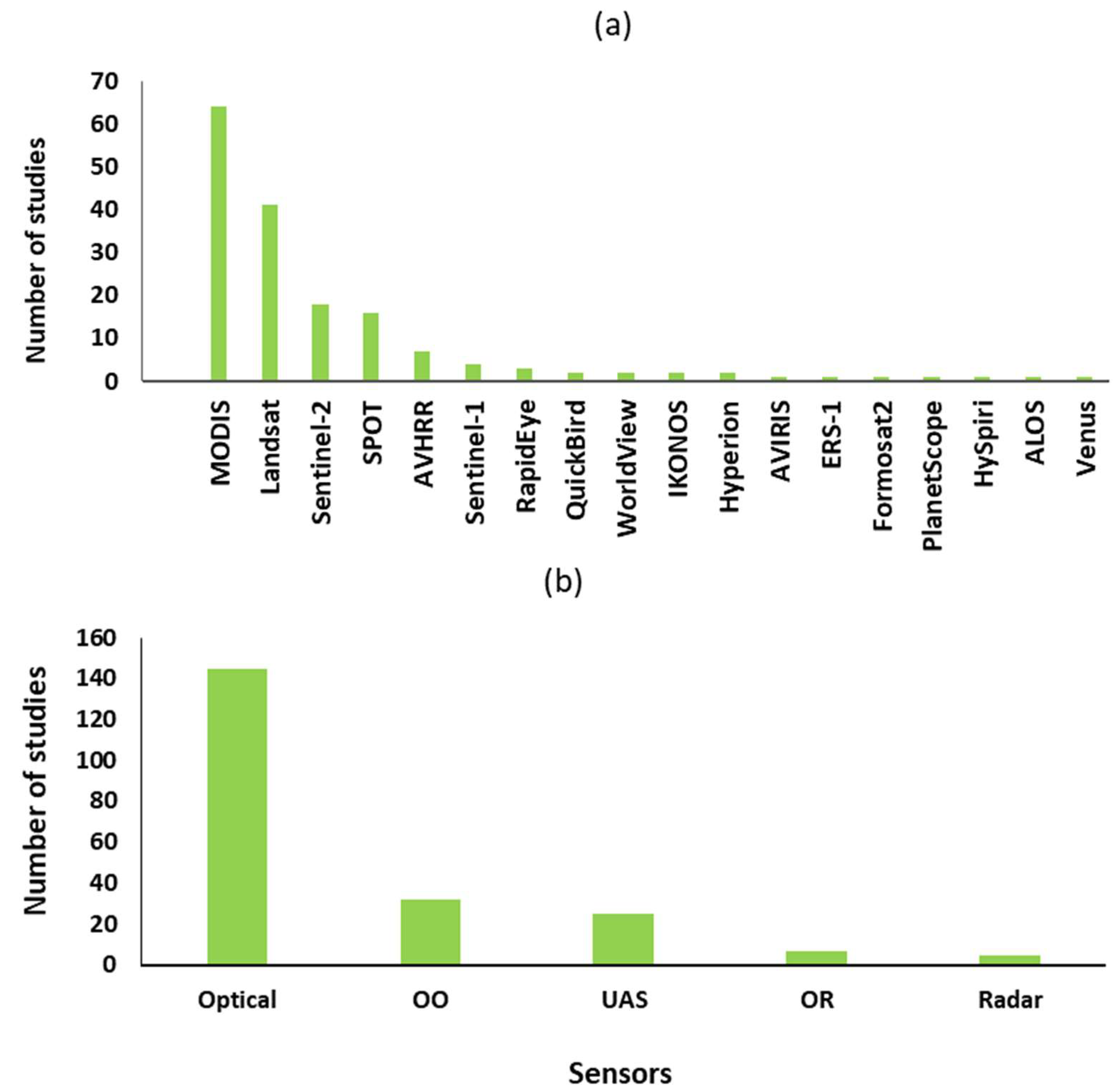
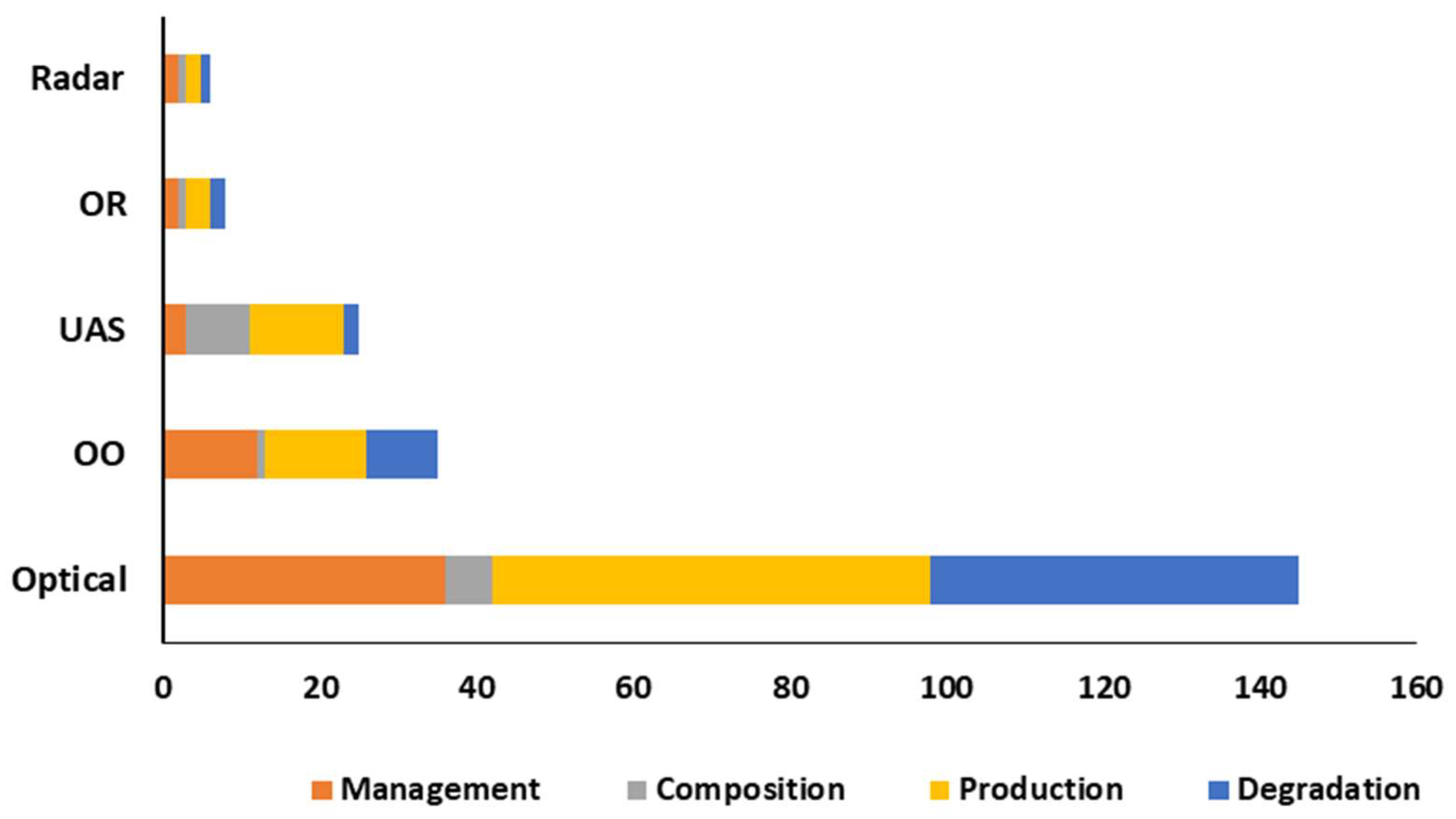
3.3. Remote Sensing Technologies Used for Pasture Monitoring
3.3.1. Description of Remote Sensing Technologies Used
3.3.2. Definition of Pasture Feature Terminologies as Used in the Review

| Satellite Instrument | Version | Altitude (km) | Launch Year | Revisit (Day) | Spatial Resolution (m) | Spectral Bands | Red Edge Inclusion | Main Focus | References |
|---|---|---|---|---|---|---|---|---|---|
| MODIS | 705 | 1999/2002 | 1 | 250/5000/1000 | 36(2, 5, 29) | Nil | Regional and global daily application. (MOD 17 model) | [6,71,90,123,124,126,155,156] | |
| Landsat | 5 to 8 | 705 | 1972 | 16 | 15/30/100 | 11 | Nil | Regional and global seasonal coverage. | [78,144,152,154,157,158,159,160,161,162,163] |
| Sentinel-2 | 786 | 2015 | 5–10 | 10/20/60 | 13–22 | Yes | Flexible resolution (revisit spatial) and red-edge inclusion. | [3,32,50,76,148,164] | |
| SPOT | 2 to 7 | 694 | 1990–2014 | 1 to 3 | 2/8 | 5 | Nil | Vegetation instrument and stereo capability. | [31,149,150,152,165] |
| AVHRR | 1 | 833 | 1998–2018 | 1 | 1100 | 5 | Nil | Daily global application archive. | [91,166,167] |
| Sentinel-1 | 693 | 2014 | 6 to 12 | Depend on acquisition mode. | 3 (0.12–0.50 nm) | Provide global free C-band SAR data. Unique acquisition mode. | [132,168,169] | ||
| RapidEye | 1 and 2 | 630 | 1998–2008 | 1 | 6.5 | 5 | Yes | Very high daily global imagery. | [140] |
| QuickBird | 482 | 2001 | 1–3.5 | 0.61/2.4 | 4 | Nil | Very high daily global imagery. | [78] | |
| Worldview | 1 to 4 | 617 | 2007–2016 | <1 | 0.31/30 | 29 | Yes | More bands for global distinctive imaging. | [170,171] |
| IKONOS | 681 | 1999 | 1–3, 14 | 1/4 | 4 | Very high imaging and stereo capability. | [157,172] | ||
| Hyperion | 705 | 2000 | 16 | 30 | hyperspectral | Narrow bands | [173,174] | ||
| ERS-1 * | 782 | 1991 | 10/30 | C-band SAR data and polarization. | [153,175] | ||||
| Formosat2 | 888 | 2004 | 1 | 2/8 | 5 | Nil | [176] | ||
| PlaneScope | 461 | 1 | 3 | 5 | Yes | Daily fine global imaging. | [173,177,178] | ||
| HySpiri | 2018 | 5 | 60 | hyperspectral | Narrow bands for characterization. | [177,179] | |||
| ALOS | 1 and 2 | 628 | 2006–2014 | 14, 46 | 2.5/10 | L-band SAR data and 4 optical bands. | Nil | Optical and SAR imaging possibilities. | [7,180] |
| Venus | 720 | 2017/2005 | 2 | 3/5.3 | 12 | Yes | High spatial and spectral application. | [177] |
| Generic Name | Traditional Name | Sensor | Spatial Resolution | Focus | Reference |
|---|---|---|---|---|---|
| UAS | Phantom | Multispectral | <1 m | Pasture biomass | [58] |
| UAS | UAS LiDAR | LiDAR sensor | 40 m | Biomass estimation and species classification | [181] |
| UAS | Phantom and Sequoia | Multispectral | 1.5 cm and 3.7 cm | Classifying fractional cover | [116] |
| UAS | Hexa Copter System | Multispectral | 10 cm | Pasture biomass productivity | [182] |
| UAS + PlanetScope (fused) | MicaSense | Multispectral | 30 cm | Aboveground net production | [114] |
| UAS | Micro MCA | Multispectral | 30 m | Pasture quality | [183] |
| UAS | AisaFENIX | Hyperspectral (VIs-SWIR | 1 m | Pasture nutrient | [142] |
| UAS | HySpex | Hyperspectral | Depend on altitude | Pasture species (classification) | [131] |
| Airborne laser scanning | Riegl LMS-Q680 sensor | LiDAR; reflectance, echo width NDSM | Depend on altitude | Pasture mapping | [184] |
| UAS | Hymap | Hyperspectral | 5 m | Pasture species (classification) | [52] |
| Aircraft mounted + calibrate Landsat 5 (TMS) | Very-large-scale aerial (VLSA) | Multispectral of Landsat | 1 mm (VLSA), Landsat 30 m | Pasture cover from Landsat calibration | [143] |
3.4. Approaches for Pasture Quantification
3.4.1. Pasture Production
| Vegetation Indices | Model | Studies Focus | Sensor | Reference |
|---|---|---|---|---|
| Ratio vegetation index (RVI), enhanced vegetation index (EVI), NDVI | Logarithmic regression | Aboveground biomass | MODIS | [64,189,194,196] |
| EVI, LAI, | Linear regression model | Aboveground biomass | Worldview, Sentinel-1, Sentinel-2, Landsat | [45,196] |
| Vegetation indices | Sparse partial least-square regression | Aboveground biomass | Sentinel-2, HySpiri, | [179,197] |
| Pasture quality | UAS, | [120,142] | ||
| AVHRR | [91] | |||
| NDVI | Power regression | Pasture biomass, forage dry biomass | MODIS, | [91] |
| LAI derived from satellite | Radiative transfer model | Pasture biomass prediction at the paddock level | Sentinel-2 | [32] |
| NDVI derived from fused satellite sensors | Linear regression model | Aboveground net primary production (i.e., carbon stock) (ANPP) estimated from Absorbed photosynthetically active radiation (APAR) at paddock level | Fusion of Landsat/MODIS | [34] |
| NDVI derived from fused satellite sensors + UAS | Linear regression + Light use efficiency model | Aboveground net primary production (ANPP) estimated from Absorbed photosynthetically active radiation (APAR) | Fusion of UAS/PlanetScope | [114] |
| To compare NDVI and FVC derived from UVA (multispectral image) | Exponential function, linear function, logarithmic function, polynomial function and power function | Estimate carbon yield canopy cover for individual plant and across | Multispectral camera (i.e., SpecTerra) | [130] |
| NDVI + cellulose absorption index derived from satellites | Linear unmixing approach and multiple linear regression | FVC, non-photosynthetic vegetation cover and bare soil | Hyperion and MODIS | [91,141] |
| Methods/Biophysical/Spectral Parameters | Machine Learning/Model | Approach | Sensor | Ground Approach | Achievement | Reference |
|---|---|---|---|---|---|---|
| LAI derived from satellite | Radiative transfer model + artificial neural network as retrieval | Pasture biomass | Sentinel-2 | [135] | ||
| NDVI derived from UAS | Statistical (GAM) + Machine Learning (RF) | Pasture biomass prediction at the paddock level | Multispectral camera | Ground calibration with RPM | 27% (GAM) and 22% (RF) | [58] |
| NDVI and spectral variables derived from satellite imagery | Artificial neural network | Pasture biomass prediction at the paddock level | Sentinel-2 | Calibration with C-Dax and RPM | 51% (ANN) and 39% (NDVI) | [3] |
| LAI + soil leaf canopy (SLC) derived from satellite | RF + Radiative transfer model (RTM) | LAI and aboveground biomass (AGB) | Sentinel-2 | Field sampling | RMSE of 0.4. | [164] |
| VIs (NDVI, EVI and Land surface water index) derived from satellite | SVM, RF and Multiple linear regression (MLR) | Estimate LAI and aboveground biomass (AGB) | Sentinel-2, Sentinel-1 Landsat | Field sampling (destructive) | 30% improvement by combining sensors | [45] |
| Surface reflectance data (Landsat 8 + MODIS) compared to NDVI, EVI +SAVI | Gaussian Process Regression (GPR) | Estimation of aboveground biomass | Landsat 8 and MODIS | Field sampling (destructive) | GPR outperformed the three VIs R2 = 0.64 and RMSE = 48.13 g/m2 | [198] |
| Spectral reflectance | ANN | Quantifying aboveground | Landsat 8 | Field sampling (destructive) | [174] | |
| Fractional of Absorbed Photosynthesis Active Radiation (FAPAR) derived from RS | Decision Tree (Machine Learning) | Estimation of herbaceous yield in a (savanna ecosystem) | Traditional FAPAR + meteorological data | ML + FAPAR + climate data performed better than FAPAR model only and/or climate variables. | [99] | |
| LAI + NDVI + Fractional vegetation cover (FVC) derived from satellite | K-NN | Mapping grazing and mowing | SPOT | Field measurement (spectrometer) | 82% | [188] |
3.4.2. Botanical Composition
| Classifier | Methods | Sensor | Accuracy | Reference |
|---|---|---|---|---|
| SVM + PCA | Pixel-based | Sentinel-2 | 80% (overall) | [133] |
| RF | Pixel-based | Sentinel-2, Sentinel-1, ALOS | 86% (overall) | [7] |
| SVM + RF | Object-image based | Landsat | ||
| Kernel + SVM | Non-linear performed better (0.55 ≤ R2CV ≤ 0.78; 6.68% ≤ nRMSECV ≤ 26.47%) | [142] | ||
| Decision tree | Object-based classification | IKONOS | 83% | [172] |
| SVM | ||||
| Decision tree | SPOT | |||
| SVM | linear regression/classification | Landsat | [136] | |
| K-NN | SPOT | Kappa index= 0.82 | ||
| Maximum Likelihood Classifier (MLC) | Object-image based | Landsat, SPOT | Landsat = 60.1%, SPOT = 65.5%, | [31] |
| Multivariate | Hierarchical clustering | Landsat | [203] | |
| RF | Pixel-based classification | Sentinel-1A, Sentinel-2 | 76%, 62%, 75% | [138] |
| RF, SVM, KNN | Pixel-based classification | Sentinel-1, Sentinel-2 | KNN 0.89, RF 0.96, SVM 0.96 | [139] |
| Multivariate | Where several treatments are needed | [204] | ||
| Fuzzy/KNN | Pixel-based | HyMap | 98% and 64% | [52] |
3.4.3. Pasture Management Traits
3.4.4. Pasture Degradation
4. Adoption of the Remote Sensing Information by End Users
5. Discussion
5.1. Trend in the Remote Sensing of Pasture Management Traits, Species Composition, Pasture Production, and Pasture Degradation
5.2. Assessing the Current Remote Sensing of Pasture Monitoring
5.3. Assessing the Approaches Used in the Remote Sensing of Pasture Monitoring
5.4. Adaptive Pasture Management and Factors That Influence the Monitoring of Pastures with Remote Sensing
5.5. Analysing End Users’ Perception and Adoption of the Remote Sensing Products and Technology
6. Conclusions
Author Contributions
Funding
Data Availability Statement
Acknowledgments
Conflicts of Interest
Appendix A

References
- Rendel, J.; Mackay, A.; Smale, P.; Manderson, A.; Scobie, D. Optimisation of the resource of land-based livestock systems to advance sustainable agriculture: A farm-level analysis. Agriculture 2020, 10, 331. [Google Scholar] [CrossRef]
- Rigge, M.; Homer, C.; Shi, H.; Wylie, B. Departures of Rangeland Fractional Component Cover and Land Cover from Landsat-Based Ecological Potential in Wyoming, USA. Rangel. Ecol. Manag. 2020, 73, 856–870. [Google Scholar] [CrossRef]
- Chen, Y.; Guerschman, J.; Shendryk, Y.; Henry, D.; Harrison, M.T. Estimating pasture biomass using sentinel-2 imagery and machine learning. Remote Sens. 2021, 13, 603. [Google Scholar] [CrossRef]
- Sándor, R.; Ehrhardt, F.; Grace, P.; Recous, S.; Smith, P.; Snow, V.; Soussana, J.-F.; Basso, B.; Bhatia, A.; Brilli, L.; et al. Ensemble modelling of carbon fluxes in grasslands and croplands. Field Crop. Res. 2020, 252, 107791. [Google Scholar] [CrossRef]
- Harrison, M.T.; Cullen, B.R.; Mayberry, D.E.; Cowie, A.L.; Bilotto, F.; Badgery, W.B.; Liu, K.; Davison, T.; Christie, K.M.; Muleke, A.; et al. Carbon myopia: The urgent need for integrated social, economic and environmental action in the livestock sector. Glob. Chang. Biol. 2021, 27, 5726–5761. [Google Scholar] [CrossRef]
- Stanimirova, R.; Arévalo, P.; Kaufmann, R.K.; Maus, V.; Lesiv, M.; Havlík, P.; Friedl, M.A. Sensitivity of Global Pasturelands to Climate Variation. Earth’s Futur. 2019, 7, 1353–1366. [Google Scholar] [CrossRef]
- Spagnuolo, O.S.B.; Jarvey, J.C.; Battaglia, M.J.; Laubach, Z.M.; Miller, M.E.; Holekamp, K.E.; Bourgeau-Chavez, L.L. Mapping Kenyan Grassland Heights across large spatial scales with combined optical and radar satellite imagery. Remote Sens. 2020, 12, 1086. [Google Scholar] [CrossRef]
- Grigera, G.; Oesterheld, M.; Pacín, F. Monitoring forage production for farmers’ decision making. Agric. Syst. 2007, 94, 637–648. [Google Scholar] [CrossRef]
- Pfadenhauer, J.S.; Klötzli, F.A. Global Vegetation; Springer International: Berlin/Heidelberg, Germany, 2020; ISBN 9783030498603. [Google Scholar]
- Rawnsley, R.P.; Smith, A.P.; Christie, K.M.; Harrison, M.T.; Eckard, R.J. Current and future direction of nitrogen fertiliser use in Australian grazing systems. Crop Pasture Sci. 2019, 70, 1034–1043. [Google Scholar]
- Kurtz, D.B.; Schellberg, J.; Braun, M. Ground and satellite based assessment of rangeland management in sub-tropical Argentina. Appl. Geogr. 2010, 30, 210–220. [Google Scholar] [CrossRef]
- Allen, V.G.; Batello, C.; Berretta, E.J.; Hodgson, J.; Kothmann, M.; Li, X.; Mcivor, J.; Milne, J.; Morris, C.; Peeters, A.; et al. An international terminology for grazing lands and grazing animals. Grass Forage Sci. 2011, 66, 2–28. [Google Scholar] [CrossRef]
- Christie, K.M.; Rawnsley, R.P.; Harrison, M.T.; Eckard, R.J. Using a modelling approach to evaluate two options for improving animal nitrogen use efficiency and reducing nitrous oxide emissions on dairy farms in southern Australia. Anim. Prod. Sci. 2014, 54, 1960–1970. [Google Scholar] [CrossRef]
- Phelan, D.C.; Harrison, M.T.; McLean, G.; Cox, H.; Pembleton, K.G.; Dean, G.J.; Parsons, D.; do Amaral Richter, M.E.; Pengilley, G.; Hinton, S.J.; et al. Advancing a farmer decision support tool for agronomic decisions on rainfed and irrigated wheat cropping in Tasmania. Agric. Syst. 2018, 167, 113–124. [Google Scholar] [CrossRef]
- Bai, Z.G.; Dent, D.L.; Olsson, L.; Schaepman, M.E. Global Assessment of Land Degradation and Improvement: 1. Identification by Remote Sensing; ISRIC-World Soil Information: Wageningen, The Netherlands, 2008. [Google Scholar]
- Stellmes, M.; Udelhoven, T.; Röder, A.; Sonnenschein, R.; Hill, J. Dryland observation at local and regional scale—Comparison of Landsat TM/ETM+ and NOAA AVHRR time series. Remote Sens. Environ. 2010, 114, 2111–2125. [Google Scholar] [CrossRef]
- McClaran, M.P.; Wei, H. Recent drought phase in a 73-year record at two spatial scales: Implications for livestock production on rangelands in the Southwestern United States. Agric. For. Meteorol. 2014, 197, 40–51. [Google Scholar] [CrossRef]
- Zucca, C.; Wu, W.; Dessena, L.; Mulas, M. Assessing the Effectiveness of Land Restoration Interventions in Dry Lands by Multitemporal Remote Sensing—A Case Study in Ouled DLIM (Marrakech, Morocco). Land Degrad. Dev. 2015, 26, 80–91. [Google Scholar] [CrossRef]
- Huang, K.; Zhang, Y.; Zhu, J.; Liu, Y.; Zu, J.; Zhang, J. The influences of climate change and human activities on vegetation dynamics in the Qinghai-Tibet plateau. Remote Sens. 2016, 8, 876. [Google Scholar] [CrossRef]
- Fetzel, T.; Petridis, P.; Noll, D.; Singh, S.J.; Fischer-Kowalski, M. Reaching a socio-ecological tipping point: Overgrazing on the Greek island of Samothraki and the role of European agricultural policies. Land Use Policy 2018, 76, 21–28. [Google Scholar] [CrossRef]
- Jansen, V.S.; Kolden, C.A.; Schmalz, H.J. The development of near real-time biomass and cover estimates for adaptive rangeland management using Landsat 7 and Landsat 8 surface reflectance products. Remote Sens. 2018, 10, 1057. [Google Scholar] [CrossRef]
- Zhou, W.; Li, J.; Yue, T. Grassland Degradation Restoration and Constructing Green Ecological Protective Screen. In Remote Sensing Monitoring and Evaluation of Degraded Grassland in China; Springer Geography; Springer: Singapore, 2020; pp. 125–138. [Google Scholar] [CrossRef]
- Li, R.; Han, R.; Yu, Q.; Qi, S.; Guo, L. Spatial heterogeneous of ecological vulnerability in arid and semi-arid area: A case of the Ningxia Hui autonomous region, China. Sustainability 2020, 12, 4401. [Google Scholar] [CrossRef]
- Ara, I.; Turner, L.; Harrison, M.T.; Monjardino, M.; deVoil, P.; Rodriguez, D. Application, adoption and opportunities for improving decision support systems in irrigated agriculture: A review. Agric. Water Manag. 2021, 257, 107161. [Google Scholar] [CrossRef]
- Reinermann, S.; Asam, S.; Kuenzer, C. Remote sensing of grassland production and management—A review. Remote Sens. 2020, 12, 1949. [Google Scholar] [CrossRef]
- Langworthy, A.D.; Rawnsley, R.P.; Freeman, M.J.; Pembleton, K.G.; Corkrey, R.; Harrison, M.T.; Lane, P.A.; Henry, D.A. Potential of summer-active temperate (C3) perennial forages to mitigate the detrimental effects of supraoptimal temperatures on summer home-grown feed production in south-eastern Australian dairying regions. Crop Pasture Sci. 2018, 69, 808–820. [Google Scholar] [CrossRef]
- Hodgkinson, K.C.; Wang, D. Preventing rangeland degradation: A shared problem for Australia and China. Rangel. J. 2020, 42, 323–328. [Google Scholar] [CrossRef]
- Fernández-Giménez, M.E.; Venable, N.H.; Angerer, J.; Fassnacht, S.R.; Reid, R.S.; Khishigbayar, J. Exploring linked ecological and cultural tipping points in Mongolia. Anthropocene 2017, 17, 46–69. [Google Scholar] [CrossRef]
- Harrison, M.T.; Roggero, P.P.; Zavattaro, L. Simple, efficient and robust techniques for automatic multi-objective function parameterisation: Case studies of local and global optimisation using APSIM. Environ. Model. Softw. 2019, 117, 109–133. [Google Scholar] [CrossRef]
- Trotter, M.G.; Lamb, D.W.; Donald, G.E.; Schneider, D.A. Evaluating an active optical sensor for quantifying and mapping green herbage mass and growth in a perennial grass pasture. Crop Pasture Sci. 2010, 61, 389–398. [Google Scholar] [CrossRef]
- Edirisinghe, A.; Clark, D.; Waugh, D. Spatio-temporal modelling of biomass of intensively grazed perennial dairy pastures using multispectral remote sensing. Int. J. Appl. Earth Obs. Geoinf. 2012, 16, 5–16. [Google Scholar] [CrossRef]
- Punalekar, S.M.; Verhoef, A.; Quaife, T.L.; Humphries, D.; Bermingham, L.; Reynolds, C.K. Application of Sentinel-2A data for pasture biomass monitoring using a physically based radiative transfer model. Remote Sens. Environ. 2018, 218, 207–220. [Google Scholar] [CrossRef]
- Ara, I.; Harrison, M.T.; Whitehead, J.; Waldner, F.; Bridle, K.; Gilfedder, L.; Marques Da Silva, J.; Marques, F.; Rawnsley, R. Modelling seasonal pasture growth and botanical composition at the paddock scale with satellite imagery. In Silico Plants 2021, 3, diaa013. [Google Scholar] [CrossRef]
- Gaffney, R.; Porensky, L.M.; Gao, F.; Irisarri, J.G.; Durante, M.; Derner, J.D.; Augustine, D.J. Using MODIS imagery, climate and soil data to estimate pasture growth rates on farms in the south-west of Western Australia. Remote Sens. 2018, 10, 1474. [Google Scholar] [CrossRef]
- Liu, Q.; Yang, Z.; Han, F.; Shi, H.; Wang, Z.; Chen, X. Ecological environment assessment in world natural heritage site based on remote-sensing data. A case study from the Bayinbuluke. Sustainability 2019, 11, 6385. [Google Scholar] [CrossRef]
- Butterfield, H.S.; Malmström, C.M. The effects of phenology on indirect measures of aboveground biomass in annual grasses. Int. J. Remote Sens. 2009, 30, 3133–3146. [Google Scholar] [CrossRef]
- Flynn, E.S.; Dougherty, C.T.; Wendroth, O. Assessment of pasture biomass with the normalized difference vegetation index from active ground-based sensors. Agron. J. 2008, 100, 114–121. [Google Scholar] [CrossRef]
- Starks, P.J.; Zhao, D.; Brown, M.A. Estimation of nitrogen concentration and in vitro dry matter digestibility of herbage of warm-season grass pastures from canopy hyperspectral reflectance measurements. Grass Forage Sci. 2008, 63, 168–178. [Google Scholar] [CrossRef]
- Starks, P.J.; Zhao, D.; Phillips, W.A.; Coleman, S.W. Development of canopy reflectance algorithms for real-time prediction of bermudagrass pasture biomass and nutritive values. Crop Sci. 2006, 46, 927–934. [Google Scholar] [CrossRef]
- Pullanagari, R.R.; Yule, I.; King, W.; Dalley, D.; Dynes, R. The use of optical sensors to estimate pasture quality. Int. J. Smart Sens. Intell. Syst. 2011, 4, 125–137. [Google Scholar] [CrossRef]
- Thulin, S.; Hill, M.J.; Held, A.; Jones, S.; Woodgate, P. Hyperspectral determination of feed quality constituents in temperate pastures: Effect of processing methods on predictive relationships from partial least squares regression. Int. J. Appl. Earth Obs. Geoinf. 2012, 19, 322–334. [Google Scholar] [CrossRef]
- Pullanagari, R.R.; Yule, I.J.; Hedley, M.J.; Tuohy, M.P.; Dynes, R.A.; King, W.M. Multi-spectral radiometry to estimate pasture quality components. Precis. Agric. 2012, 13, 442–456. [Google Scholar] [CrossRef]
- Serrano, J.; Shahidian, S.; Marques Da Silva, J.; Sales-Baptista, E.; Ferraz De Oliveira, I.; Lopes De Castro, J.; Pereira, A.; Cancela De Abreu, M.; Machado, E.; Carvalho, M.D. Tree influence on soil and pasture: Contribution of proximal sensing to pasture productivity and quality estimation in montado ecosystems. Int. J. Remote Sens. 2018, 39, 4801–4829. [Google Scholar] [CrossRef]
- Guo, X.; Wilmshurst, J.F.; Li, Z. Comparison of laboratory and field remote sensing methods to measure forage quality. Int. J. Environ. Res. Public Health 2010, 7, 3513–3530. [Google Scholar] [CrossRef] [PubMed]
- Wang, J.; Xiao, X.; Bajgain, R.; Starks, P.; Steiner, J.; Doughty, R.B.; Chang, Q. Estimating leaf area index and aboveground biomass of grazing pastures using Sentinel-1, Sentinel-2 and Landsat images. ISPRS J. Photogramm. Remote Sens. 2019, 154, 189–201. [Google Scholar] [CrossRef]
- Wachendorf, M.; Fricke, T.; Möckel, T. Remote sensing as a tool to assess botanical composition, structure, quantity and quality of temperate grasslands. Grass Forage Sci. 2018, 73, 1–14. [Google Scholar] [CrossRef]
- Moeckel, T.; Safari, H.; Reddersen, B.; Fricke, T.; Wachendorf, M. Fusion of ultrasonic and spectral sensor data for improving the estimation of biomass in grasslands with heterogeneous sward structure. Remote Sens. 2017, 9, 98. [Google Scholar] [CrossRef]
- Starks, P.J.; Zhao, D.; Phillips, W.A.; Coleman, S.W. Herbage mass, nutritive value and canopy spectral reflectance of bermudagrass pastures. Grass Forage Sci. 2006, 61, 101–111. [Google Scholar] [CrossRef]
- Wagle, P.; Gowda, P.H.; Northup, B.K.; Starks, P.J.; Neel, J.P.S. Response of tallgrass prairie to management in the U.S. Southern great plains: Site descriptions, management practices, and eddy covariance instrumentation for a Long-Term Experiment. Remote Sens. 2019, 11, 1988. [Google Scholar] [CrossRef]
- Serrano, J.; Shahidian, S.; da Silva, J.M.; Paixão, L.; Carreira, E.; Carmona-Cabezas, R.; Nogales-Bueno, J.; Rato, A.E. Evaluation of near infrared spectroscopy (NIRS) and remote sensing (RS) for estimating pasture quality in Mediterranean montado ecosystem. Appl. Sci. 2020, 10, 4463. [Google Scholar] [CrossRef]
- Röder, A.; Udelhoven, T.; Hill, J.; del Barrio, G.; Tsiourlis, G. Trend analysis of Landsat-TM and -ETM+ imagery to monitor grazing impact in a rangeland ecosystem in Northern Greece. Remote Sens. Environ. 2008, 112, 2863–2875. [Google Scholar] [CrossRef]
- Oldeland, J.; Dorigo, W.; Lieckfeld, L.; Lucieer, A.; Jürgens, N. Combining vegetation indices, constrained ordination and fuzzy classification for mapping semi-natural vegetation units from hyperspectral imagery. Remote Sens. Environ. 2010, 114, 1155–1166. [Google Scholar] [CrossRef]
- Kakembo, V.; Ndou, N. Relating vegetation condition to grazing management systems in the central Keiskamma Catchment, Eastern Cape Province, South Africa. Land Degrad. Dev. 2019, 30, 1052–1060. [Google Scholar] [CrossRef]
- Dorigo, W.; Richter, R.; Baret, F.; Bamler, R.; Wagner, W. Enhanced Automated Canopy Characterization from Hyperspectral Data by a Novel Two Step Radiative Transfer Model Inversion Approach. Remote Sens. 2009, 1, 1139–1170. [Google Scholar] [CrossRef]
- Boch, S.; Bedolla, A.; Ecker, K.T.; Ginzler, C.; Graf, U.; Küchler, H.; Küchler, M.; Nobis, M.P.; Holderegger, R.; Bergamini, A. Threatened and specialist species suffer from increased wood cover and productivity in Swiss steppes. Flora Morphol. Distrib. Funct. Ecol. Plants 2019, 258, 151444. [Google Scholar] [CrossRef]
- Redhead, J.; Cuevas-Gonzales, M.; Smith, G.; Gerard, F.; Pywell, R. Assessing the effectiveness of scrub management at the landscape scale using rapid field assessment and remote sensing. J. Environ. Manag. 2012, 97, 102–108. [Google Scholar] [CrossRef] [PubMed]
- Verrelst, J.; Malenovský, Z.; Van der Tol, C.; Camps-Valls, G.; Gastellu-Etchegorry, J.-P.; Lewis, P.; North, P.; Moreno, J. Quantifying Vegetation Biophysical Variables from Imaging Spectroscopy Data: A Review on Retrieval Methods. Surv. Geophys. 2019, 40, 589–629. [Google Scholar] [CrossRef] [PubMed]
- De Rosa, D.; Basso, B.; Fasiolo, M.; Friedl, J.; Fulkerson, B.; Grace, P.R.; Rowlings, D.W. Predicting pasture biomass using a statistical model and machine learning algorithm implemented with remotely sensed imagery. Comput. Electron. Agric. 2021, 180, 105880. [Google Scholar] [CrossRef]
- Schellberg, J.; Hill, M.J.; Gerhards, R.; Rothmund, M.; Braun, M. Precision agriculture on grassland: Applications, perspectives and constraints. Eur. J. Agron. 2008, 29, 59–71. [Google Scholar] [CrossRef]
- Jadhav, R.N.; Kimothi, M.M.; Kandya, A.K. Grassland mapping/monitoring of Banni, Kachchh (Gujarat) using remotely-sensed data. Int. J. Remote Sens. 1993, 14, 3093–3103. [Google Scholar] [CrossRef]
- Na, Y.; Li, J.; Hoshino, B.; Bao, S.; Qin, F.; Myagmartseren, P. Effects of different grazing systems on aboveground biomass and plant species dominance in typical Chinese and Mongolian steppes. Sustainability 2018, 10, 4753. [Google Scholar] [CrossRef]
- Xu, D.; Chen, B.; Shen, B.; Wang, X.; Yan, Y.; Xu, L.; Xin, X. The Classification of Grassland Types Based on Object-Based Image Analysis with Multisource Data. Rangel. Ecol. Manag. 2019, 72, 318–326. [Google Scholar] [CrossRef]
- Kimura, R.; Moriyama, M. Use of a satellite-based aridity index to monitor decreased soil water content and grass growth in grasslands of north-east Asia. Remote Sens. 2020, 12, 3556. [Google Scholar] [CrossRef]
- Wang, X.; Dong, J.; Baoyin, T.; Bao, Y. Estimation and climate factor contribution of aboveground biomass in Inner Mongolia’s typical/desert steppes. Sustainability 2019, 11, 6559. [Google Scholar] [CrossRef]
- Jansen, V.S.; Kolden, C.A.; Taylor, R.V.; Newingham, B.A. Quantifying livestock effects on bunchgrass vegetation with Landsat ETM+ data across a single growing season. Int. J. Remote Sens. 2016, 37, 150–175. [Google Scholar] [CrossRef]
- Xu, D.; Koper, N.; Guo, X. Quantifying the influences of grazing, climate and their interactions on grasslands using Landsat TM images. Grassl. Sci. 2018, 64, 118–127. [Google Scholar] [CrossRef]
- Reeves, M.C.; Hanberry, B.B.; Wilmer, H.; Kaplan, N.E.; Lauenroth, W.K. An Assessment of Production Trends on the Great Plains from 1984 to 2017. Rangel. Ecol. Manag. 2020, 78, 165–179. [Google Scholar] [CrossRef]
- Guo, X.; Price, K.P.; Stiles, J. Grasslands Discriminant Analysis Using Landsat TM Single and Multitemporal Data. Photogramm. Eng. Remote Sens. 2003, 69, 1255–1262. [Google Scholar] [CrossRef]
- Chu, D. Aboveground biomass estimates of grassland in the north tibet using modis remote sensing approaches. Appl. Ecol. Environ. Res. 2020, 18, 7655–7672. [Google Scholar] [CrossRef]
- Wei, D.; Zhao, H.; Zhang, J.; Qi, Y.; Wang, X. Human activities alter response of alpine grasslands on Tibetan Plateau to climate change. J. Environ. Manag. 2020, 262, 110335. [Google Scholar] [CrossRef]
- Lyu, X.; Li, X.; Gong, J.; Wang, H.; Dang, D.; Dou, H.; Li, S.; Liu, S. Comprehensive grassland degradation monitoring by remote sensing in Xilinhot, Inner Mongolia, China. Sustainability 2020, 12, 3682. [Google Scholar] [CrossRef]
- Ma, Q.; Chai, L.; Hou, F.; Chang, S.; Ma, Y.; Tsunekawa, A.; Cheng, Y. Quantifying grazing intensity using remote sensing in alpine meadows on Qinghai-Tibetan Plateau. Sustainability 2019, 11, 417. [Google Scholar] [CrossRef]
- Dong, S.; Shang, Z.; Gao, J.; Boone, R.B. Enhancing sustainability of grassland ecosystems through ecological restoration and grazing management in an era of climate change on Qinghai-Tibetan Plateau. Agric. Ecosyst. Environ. 2020, 287, 106684. [Google Scholar] [CrossRef]
- Bretas, I.L.; Valente, D.S.M.; Silva, F.F.; Chizzotti, M.L.; Paulino, M.F.; D’Áurea, A.P.; Paciullo, D.S.C.; Pedreira, B.C.; Chizzotti, F.H.M. Prediction of aboveground biomass and dry-matter content in brachiaria pastures by combining meteorological data and satellite imagery. Grass Forage Sci. 2021, 76, 340–352. [Google Scholar] [CrossRef]
- Hott, M.C.; Carvalho, L.M.T.; Antunes, M.A.H.; Resende, J.C.; Rocha, W.S.D. Analysis of grassland degradation in Zona da Mata, MG, Brazil, based on NDVI time series data with the integration of phenological metrics. Remote Sens. 2019, 11, 2956. [Google Scholar] [CrossRef]
- Sibanda, M.; Onisimo, M.; Dube, T.; Mabhaudhi, T. Quantitative assessment of grassland foliar moisture parameters as an inference on rangeland condition in the mesic rangelands of southern Africa. Int. J. Remote Sens. 2021, 42, 1474–1491. [Google Scholar] [CrossRef]
- Sandhage-Hofmann, A.; Löffler, J.; Kotzé, E.; Weijers, S.; Wingate, V.; Wundram, D.; Weihermüller, L.; Pape, R.; du Preez, C.C.; Amelung, W. Woody encroachment and related soil properties in different tenure-based management systems of semiarid rangelands. Geoderma 2020, 372, 114399. [Google Scholar] [CrossRef]
- Röder, A.; Kuemmerle, T.; Hill, J.; Papanastasis, V.P.; Tsiourlis, G.M. Adaptation of a grazing gradient concept to heterogeneous Mediterranean rangelands using cost surface modelling. Ecol. Modell. 2007, 204, 387–398. [Google Scholar] [CrossRef]
- Dostine, P.L.; Woinarski, J.C.Z.; Mackey, B.; Nix, H. Patterns of grassland productivity, composition and seed abundance, and the diet of the flock bronzewing pigeon Phaps histrionica at one site in northern Australia over a period of marked seasonal change. Wildl. Res. 2014, 41, 343–355. [Google Scholar] [CrossRef]
- Watson, C.J.; Restrepo-Coupe, N.; Huete, A.R. Multi-scale phenology of temperate grasslands: Improving monitoring and management with near-surface phenocams. Front. Environ. Sci. 2019, 7, 14. [Google Scholar] [CrossRef]
- Donald, G.E.; Scott, J.M.; Vickery, P.J. Satellite derived evidence of whole farmlet and paddock responses to management and climate. Anim. Prod. Sci. 2013, 53, 699–710. [Google Scholar] [CrossRef]
- Gallego, F.; Paruelo, J.M.; Baeza, S.; Altesor, A. Distinct ecosystem types respond differentially to grazing exclosure. Austral Ecol. 2020, 45, 548–556. [Google Scholar] [CrossRef]
- Castro, M.; Ameray, A.; Castro, J.P. A new approach to quantify grazing pressure under mediterranean pastoral systems using GIS and remote sensing. Int. J. Remote Sens. 2020, 41, 5371–5387. [Google Scholar] [CrossRef]
- Fenetahun, Y.; Xu, X.W.; Wang, Y.D. Analysis of eco-environmental vulnerability: Implication for bush encroachment and livestock population dynamics of the teltele rangeland, southern, ethiopia. Appl. Ecol. Environ. Res. 2020, 18, 7255–7278. [Google Scholar] [CrossRef]
- Wall, A.J.; Asher, G.W.; Netzer, M.S.; Johnson, M.G.H.; O’neill, K.T.; Littlejohn, R.P.; Cox, N. Farmed red deer home range, habitat use and daily movement patterns in a southland, New Zealand, tussock grassland over calving and lactation. Anim. Prod. Sci. 2018, 59, 549–563. [Google Scholar] [CrossRef]
- Schucknecht, A.; Meroni, M.; Kayitakire, F.; Boureima, A. Phenology-based biomass estimation to support rangeland management in semi-arid environments. Remote Sens. 2017, 9, 463. [Google Scholar] [CrossRef]
- Hill, M.J.; Donald, G.E.; Vickery, P.J.; Furnival, E.P. Integration of satellite remote sensing, simple bioclimatic models and GIS for assessment of pastoral development for a commercial grazing enterprise. Aust. J. Exp. Agric. 1996, 36, 309–321. [Google Scholar] [CrossRef]
- Doan, T.; Guo, X. Understanding Bison Carrying Capacity Estimation in Northern Great Plains Using Remote Sensing and GIS. Can. J. Remote Sens. 2019, 45, 139–162. [Google Scholar] [CrossRef]
- Goodrich, D.C.; Wei, H.; Burns, I.S.; Guertin, D.P.; Spaeth, K.; Hernandez, M.; Holifield-Collins, C.; Kautz, M.; Heilman, P.; Levick, L.R.; et al. Evaluation of Conservation Effects Assessment Project Grazing Lands conservation practices on the Cienega Creek watershed in southeast Arizona with AGWA/RHEM modeling tools. J. Soil Water Conserv. 2020, 75, 304–318. [Google Scholar] [CrossRef]
- de Leeuw, J.; Rizayeva, A.; Namazov, E.; Bayramov, E.; Marshall, M.T.; Etzold, J.; Neudert, R. Application of the MODIS MOD 17 Net Primary Production product in grassland carrying capacity assessment. Int. J. Appl. Earth Obs. Geoinf. 2019, 78, 66–76. [Google Scholar] [CrossRef]
- Geerken, R.; Ilaiwi, M. Assessment of rangeland degradation and development of a strategy for rehabilitation. Remote Sens. Environ. 2004, 90, 490–504. [Google Scholar] [CrossRef]
- Jones, M.O.; Allred, B.W.; Naugle, D.E.; Maestas, J.D.; Donnelly, P.; Metz, L.J.; Karl, J.; Smith, R.; Bestelmeyer, B.; Boyd, C.; et al. Innovation in rangeland monitoring: Annual, 30 m, plant functional type percent cover maps for U.S. rangelands, 1984–2017. Ecosphere 2018, 9, e02430. [Google Scholar] [CrossRef]
- Mekuyie, M.; Jordaan, A.; Melka, Y. Land-use and land-cover changes and their drivers in rangeland-dependent pastoral communities in the southern Afar Region of Ethiopia. Afr. J. Range Forage Sci. 2018, 35, 33–43. [Google Scholar] [CrossRef]
- Khishigbayar, J.; Fernández-Giménez, M.E.; Angerer, J.P.; Reid, R.S.; Chantsallkham, J.; Baasandorj, Y.; Zumberelmaa, D. Mongolian rangelands at a tipping point? Biomass and cover are stable but composition shifts and richness declines after 20years of grazing and increasing temperatures. J. Arid. Environ. 2015, 115, 100–112. [Google Scholar] [CrossRef]
- Liu, M.; Dries, L.; Heijman, W.; Huang, J.; Zhu, X.; Hu, Y.; Chen, H. The Impact of Ecological Construction Programs on Grassland Conservation in Inner Mongolia, China. Land Degrad. Dev. 2018, 29, 326–336. [Google Scholar] [CrossRef]
- An, N.; Price, K.P.; Blair, J.M. Estimating above-ground net primary productivity of the tallgrass prairie ecosystem of the Central Great Plains using AVHRR NDVI. Int. J. Remote Sens. 2013, 34, 3717–3735. [Google Scholar] [CrossRef]
- An, R.; Wang, H.-L.; Feng, X.-Z.; Wu, H.; Wang, Z.; Wang, Y.; Shen, X.-J.; Lu, C.-H.; Quaye-Ballard, J.A.; Chen, Y.-H.; et al. Monitoring rangeland degradation using a novel local NPP scaling based scheme over the “Three-River Headwaters” region, hinterland of the Qinghai-Tibetan Plateau. Quat. Int. 2017, 444, 97–114. [Google Scholar] [CrossRef]
- Feng, Y.; Wu, J.; Zhang, J.; Zhang, X.; Song, C. Identifying the relative contributions of climate and grazing to both direction and magnitude of Alpine grassland productivity dynamics from 1993 to 2011 on the Northern Tibetan Plateau. Remote Sens. 2017, 9, 136. [Google Scholar] [CrossRef]
- Diouf, A.A.; Hiernaux, P.; Brandt, M.; Faye, G.; Djaby, B.; Diop, M.B.; Ndione, J.A.; Tychon, B. Do agrometeorological data improve optical satellite-based estimations of the herbaceous yield in Sahelian semi-arid ecosystems? Remote Sens. 2016, 8, 668. [Google Scholar] [CrossRef]
- Yang, X.; Guo, X.; Fitzsimmons, M. Assessing light to moderate grazing effects on grassland production using satellite imagery. Int. J. Remote Sens. 2012, 33, 5087–5104. [Google Scholar] [CrossRef]
- Nightingale, J.M.; Phinn, S.R. Assessment of relationships between precipitation and satellite derived vegetation condition within South Australia. Aust. Geogr. Stud. 2003, 41, 180–195. [Google Scholar] [CrossRef]
- De Keersmaecker, W.; van Rooijen, N.; Lhermitte, S.; Tits, L.; Schaminée, J.; Coppin, P.; Honnay, O.; Somers, B. Species-rich semi-natural grasslands have a higher resistance but a lower resilience than intensively managed agricultural grasslands in response to climate anomalies. J. Appl. Ecol. 2016, 53, 430–439. [Google Scholar] [CrossRef]
- Shrestha, S.; Rahimzadeh-Bajgiran, P.; De Urioste-Stone, S. Probing recent environmental changes and resident perceptions in Upper Himalaya, Nepal. Remote Sens. Appl. Soc. Environ. 2020, 18, 100315. [Google Scholar] [CrossRef]
- Feng, X.M.; Zhao, Y.S. Grazing intensity monitoring in northern China steppe: Integrating CENTURY model and MODIS data. Ecol. Indic. 2011, 11, 175–182. [Google Scholar] [CrossRef]
- Fenetahun, Y.; Yong-Dong, W.; You, Y.; Xinwen, X. Dynamics of forage and land cover changes in Teltele district of Borana rangelands, southern Ethiopia: Using geospatial and field survey data. BMC Ecol. 2020, 20, 55. [Google Scholar] [CrossRef] [PubMed]
- Akinyemi, F.O.; Kgomo, M.O. Vegetation dynamics in African drylands: An assessment based on the Vegetation Degradation Index in an agro-pastoral region of Botswana. Reg. Environ. Chang. 2019, 19, 2027–2039. [Google Scholar] [CrossRef]
- Ye, H.; Huang, X.-T.; Luo, G.-P.; Wang, J.-B.; Zhang, M.; Wang, X.-X. Improving remote sensing-based net primary production estimation in the grazed land with defoliation formulation model. J. Mt. Sci. 2019, 16, 323–336. [Google Scholar] [CrossRef]
- Shoko, C.; Mutanga, O.; Dube, T. Remotely sensed C3 and C4 grass species aboveground biomass variability in response to seasonal climate and topography. Afr. J. Ecol. 2019, 57, 477–489. [Google Scholar] [CrossRef]
- Cao, Y.; Wu, J.; Zhang, X.; Niu, B.; Li, M.; Zhang, Y.; Wang, X.; Wang, Z. Dynamic forage-livestock balance analysis in alpine grasslands on the Northern Tibetan Plateau. J. Environ. Manag. 2019, 238, 352–359. [Google Scholar] [CrossRef]
- Li, C.; de Jong, R.; Schmid, B.; Wulf, H.; Schaepman, M.E. Spatial variation of human influences on grassland biomass on the Qinghai-Tibetan plateau. Sci. Total Environ. 2019, 665, 678–689. [Google Scholar] [CrossRef]
- Donald, G.E.; Gherardi, S.G.; Edirisinghe, A.; Gittins, S.P.; Henry, D.A.; Mata, G. Using MODIS imagery, climate and soil data to estimate pasture growth rates on farms in the south-west of Western Australia. Anim. Prod. Sci. 2010, 50, 611–615. [Google Scholar] [CrossRef]
- Addimando, N.; Nana, E.; Bocchiola, D. Modeling pasture dynamics in a mediterranean environment: Case study in Sardinia, Italy. J. Irrig. Drain. Eng. 2015, 141, 04014063. [Google Scholar] [CrossRef]
- Marston, C.G.; Aplin, P.; Wilkinson, D.M.; Field, R.; O’Regan, H.J. Scrubbing up: Multi-scale investigation of woody encroachment in a Southern African savannah. Remote Sens. 2017, 9, 419. [Google Scholar] [CrossRef]
- Liu, H.; Dahlgren, R.A.; Larsen, R.E.; Devine, S.M.; Roche, L.M.; O’ Geen, A.T.; Wong, A.J.Y.; Covello, S.; Jin, Y. Estimating rangeland forage production using remote sensing data from a Small Unmanned Aerial System (sUAS) and planetscope satellite. Remote Sens. 2019, 11, 595. [Google Scholar] [CrossRef]
- Dieguez, F.J.; Pereira, M. Uruguayan native grasslands net aerial primary production model and its application on safe stocking rate concept. Ecol. Modell. 2020, 430, 109060. [Google Scholar] [CrossRef]
- Gillan, J.K.; Karl, J.W.; van Leeuwen, W.J.D. Integrating drone imagery with existing rangeland monitoring programs. Environ. Monit. Assess. 2020, 192, 269. [Google Scholar] [CrossRef] [PubMed]
- Yu, R.; Evans, A.J.; Malleson, N. An agent-based model for assessing grazing strategies and institutional arrangements in Zeku, China. Agric. Syst. 2019, 171, 135–142. [Google Scholar] [CrossRef]
- Zhang, B.; Zhang, L.; Xie, D.; Yin, X.; Liu, C.; Liu, G. Application of synthetic NDVI time series blended from landsat and MODIS data for grassland biomass estimation. Remote Sens. 2016, 8, 10. [Google Scholar] [CrossRef]
- Sanderson, M.A.; Liebig, M.A.; Hendrickson, J.R.; Kronberg, S.L.; Toledo, D.; Derner, J.D.; Reeves, J.L. Long-term agroecosystem research on northern great plains mixed-grass prairie near mandan, north dakota. Can. J. Plant Sci. 2015, 95, 1101–1116. [Google Scholar] [CrossRef]
- Pellissier, P.A.; Ollinger, S.V.; Lepine, L.C.; Palace, M.W.; McDowell, W.H. Remote sensing of foliar nitrogen in cultivated grasslands of human dominated landscapes. Remote Sens. Environ. 2015, 167, 88–97. [Google Scholar] [CrossRef]
- Fassnacht, F.E.; Li, L.; Fritz, A. Mapping degraded grassland on the Eastern Tibetan Plateau with multi-temporal Landsat 8 data—Where do the severely degraded areas occur? Int. J. Appl. Earth Obs. Geoinf. 2015, 42, 115–127. [Google Scholar] [CrossRef]
- Wylie, B.K.; Boyte, S.P.; Major, D.J. Ecosystem performance monitoring of rangelands by integrating modeling and remote sensing. Rangel. Ecol. Manag. 2012, 65, 241–252. [Google Scholar] [CrossRef]
- Hudson, T.D.; Reeves, M.C.; Hall, S.A.; Yorgey, G.G.; Neibergs, J.S. Big landscapes meet big data: Informing grazing management in a variable and changing world. Rangelands 2021, 43, 17–28. [Google Scholar] [CrossRef]
- Dingaan, M.N.V.; Tsubo, M. Improved assessment of pasture availability in semi-arid grassland of South Africa. Environ. Monit. Assess. 2019, 191, 733. [Google Scholar] [CrossRef] [PubMed]
- Jafari, R.; Bashari, H.; Tarkesh, M. Discriminating and monitoring rangeland condition classes with MODIS NDVI and EVI indices in Iranian arid and semi-arid lands. Arid. Land Res. Manag. 2017, 31, 94–110. [Google Scholar] [CrossRef]
- Rigge, M.; Smart, A.; Wylie, B.; Gilmanov, T.; Johnson, P. Linking phenology and biomass productivity in south dakota mixed-grass prairie. Rangel. Ecol. Manag. 2013, 66, 579–587. [Google Scholar] [CrossRef]
- Minor, T.B.; Lancaster, J.; Wade, T.G.; Wickham, J.D.; Whitford, W.; Jones, K.B. Evaluating change in rangeland condition using multitemporal AVHRR data and geographic information system analysis. Environ. Monit. Assess. 1999, 59, 211–223. [Google Scholar] [CrossRef]
- Duan, C.; Shi, P.; Song, M.; Zhang, X.; Zong, N.; Zhou, C. Land use and land cover change in the Kailash Sacred Landscape of China. Sustainability 2019, 11, 1788. [Google Scholar] [CrossRef]
- Elmore, A.J.; Asner, G.P. Effects of grazing intensity on soil carbon stocks following deforestation of a Hawaiian dry tropical forest. Glob. Chang. Biol. 2006, 12, 1761–1772. [Google Scholar] [CrossRef]
- Liu, N.; Harper, R.J.; Handcock, R.N.; Evans, B.; Sochacki, S.J.; Dell, B.; Walden, L.L.; Liu, S. Seasonal timing for estimating carbon mitigation in revegetation of abandoned agricultural land with high spatial resolution remote sensing. Remote Sens. 2017, 9, 545. [Google Scholar] [CrossRef]
- Möckel, T.; Dalmayne, J.; Schmid, B.C.; Prentice, H.C.; Hall, K. Airborne hyperspectral data predict fine-scale plant species diversity in grazed dry grasslands. Remote Sens. 2016, 8, 133. [Google Scholar] [CrossRef]
- Raab, C.; Riesch, F.; Tonn, B.; Barrett, B.; Meißner, M.; Balkenhol, N.; Isselstein, J. Target-oriented habitat and wildlife management: Estimating forage quantity and quality of semi-natural grasslands with Sentinel-1 and Sentinel-2 data. Remote Sens. Ecol. Conserv. 2020, 6, 381–398. [Google Scholar] [CrossRef]
- Wakulinśka, M.; Marcinkowska-Ochtyra, A. Multi-temporal sentinel-2 data in classification of mountain vegetation. Remote Sens. 2020, 12, 2696. [Google Scholar] [CrossRef]
- Bayle, A.; Carlson, B.Z.; Thierion, V.; Isenmann, M.; Choler, P. Improved mapping of mountain shrublands using the sentinel-2 red-edge band. Remote Sens. 2019, 11, 2807. [Google Scholar] [CrossRef]
- Klingler, A.; Schaumberger, A.; Vuolo, F.; Kalmár, L.B.; Pötsch, E.M. Comparison of Direct and Indirect Determination of Leaf Area Index in Permanent Grassland. PFG-J. Photogramm. Remote Sens. Geoinf. Sci. 2020, 88, 369–378. [Google Scholar] [CrossRef]
- Rufin, P.; Müller, H.; Pflugmacher, D.; Hostert, P. Land use intensity trajectories on Amazonian pastures derived from Landsat time series. Int. J. Appl. Earth Obs. Geoinf. 2015, 41, 1–10. [Google Scholar] [CrossRef]
- Wang, J.; Li, A.; Bian, J. Simulation of the grazing effects on grassland aboveground net primary production using DNDC model combined with time-series remote sensing data-a case study in Zoige plateau, China. Remote Sens. 2016, 8, 168. [Google Scholar] [CrossRef]
- Crabbe Richard, A.; Lamb David, W.; Edwards, C. Discriminating between C3, C4, and Mixed C3/C4 Pasture Grasses of a Grazed Landscape Using Multi-Temporal Sentinel-1a Data Richard. Remote Sens. 2019, 11, 253. [Google Scholar] [CrossRef]
- Crabbe, R.A.; Lamb, D.; Edwards, C. Discrimination of species composition types of a grazed pasture landscape using Sentinel-1 and Sentinel-2 data. Int. J. Appl. Earth Obs. Geoinf. 2020, 84, 101978. [Google Scholar] [CrossRef]
- Chabalala, Y.; Adam, E.; Oumar, Z.; Ramoelo, A. Exploiting the capabilities of Sentinel-2 and RapidEye for predicting grass nitrogen across different grass communities in a protected area. Appl. Geomatics 2020, 12, 379–395. [Google Scholar] [CrossRef]
- Guerschman, J.P.; Hill, M.J.; Renzullo, L.J.; Barrett, D.J.; Marks, A.S.; Botha, E.J. Estimating fractional cover of photosynthetic vegetation, non-photosynthetic vegetation and bare soil in the Australian tropical savanna region upscaling the EO-1 Hyperion and MODIS sensors. Remote Sens. Environ. 2009, 113, 928–945. [Google Scholar] [CrossRef]
- Pullanagari, R.R.; Kereszturi, G.; Yule, I.J. Mapping of macro and micro nutrients of mixed pastures using airborne AisaFENIX hyperspectral imagery. ISPRS J. Photogramm. Remote Sens. 2016, 117, 1–10. [Google Scholar] [CrossRef]
- Sivanpillai, R.; Booth, D.T. Characterizing rangeland vegetation using Landsat and 1-mm VLSA data in central Wyoming (USA). Agrofor. Syst. 2008, 73, 55–64. [Google Scholar] [CrossRef]
- Hagen, S.C.; Heilman, P.; Marsett, R.; Torbick, N.; Salas, W.; Van Ravensway, J.; Qi, J. Mapping total vegetation cover across western rangelands with moderate-resolution imaging spectroradiometer data. Rangel. Ecol. Manag. 2012, 65, 456–467. [Google Scholar] [CrossRef]
- Mueller, T.; Olson, K.A.; Fuller, T.K.; Schaller, G.B.; Murray, M.G.; Leimgruber, P. In search of forage: Predicting dynamic habitats of Mongolian gazelles using satellite-based estimates of vegetation productivity. J. Appl. Ecol. 2008, 45, 649–658. [Google Scholar] [CrossRef]
- Tiscornia, G.; Baethgen, W.; Ruggia, A.; Do Carmo, M.; Ceccato, P. Can we monitor height of native grasslands in Uruguay with earth observation? Remote Sens. 2019, 11, 1801. [Google Scholar] [CrossRef]
- Hunt, E.R., Jr.; Everitt, J.H.; Ritchie, J.C.; Moran, M.S.; Booth, D.T.; Anderson, G.L.; Clark, P.E.; Seyfried, M.S. Applications and Research Using Remote Sensing for Rangeland Management. Photogramm. Eng. Remote Sens. 2003, 69, 675–693. [Google Scholar] [CrossRef]
- Meshesha, D.T.; Ahmed, M.M.; Abdi, D.Y.; Haregeweyn, N. Prediction of grass biomass from satellite imagery in Somali regional state, eastern Ethiopia. Heliyon 2020, 6, e05272. [Google Scholar] [CrossRef]
- Hanna, M.M.; Steyn-Ross, D.A.; Steyn-Ross, M. Estimating biomass for New Zealand pasture using optical remote sensing techniques. Geocarto Int. 1999, 14, 89–94. [Google Scholar] [CrossRef]
- Yang, X.; Guo, X. Investigating vegetation biophysical and spectral parameters for detecting light to moderate grazing effects: A case study in mixed grass prairie. Cent. Eur. J. Geosci. 2011, 3, 336–348. [Google Scholar] [CrossRef]
- Lopes, M.; Fauvel, M.; Ouin, A.; Girard, S. Spectro-temporal heterogeneity measures from dense high spatial resolution satellite image time series: Application to grassland species diversity estimation. Remote Sens. 2017, 9, 993. [Google Scholar] [CrossRef]
- Maynard, C.L.; Lawrence, R.L.; Nielsen, G.A.; Decker, G. Ecological site descriptions and remotely sensed imagery as a tool for rangeland evaluation. Can. J. Remote Sens. 2007, 33, 109–115. [Google Scholar] [CrossRef]
- Smith, A.M.; Major, D.J.; McNeil, R.L.; Willms, W.D.; Brisco, B.; Brown, R.J. Complementarity of radar and visible-infrared sensors in assessing rangeland condition. Remote Sens. Environ. 1995, 52, 173–180. [Google Scholar] [CrossRef]
- Aragón, R.; Oesterheld, M. Linking vegetation heterogeneity and functional attributes of temperate grasslands through remote sensing. Appl. Veg. Sci. 2008, 11, 117–130. [Google Scholar] [CrossRef]
- Jin, Y.; Yang, X.; Li, Z.; Qin, Z.; Zhang, H.; Xu, B. Remote sensing estimation of forage mass and spatiotemporal change analysis in the Beijing-Tianjin sandstorm source region, China. Int. J. Remote Sens. 2019, 40, 2212–2226. [Google Scholar] [CrossRef]
- Lebed, L.; Qi, J.; Heilman, P. An ecological assessment of pasturelands in the Balkhash area of Kazakhstan with remote sensing and models. Environ. Res. Lett. 2012, 7, 025203. [Google Scholar] [CrossRef]
- Sant, E.D.; Simonds, G.E.; Ramsey, R.D.; Larsen, R.T. Assessment of sagebrush cover using remote sensing at multiple spatial and temporal scales. Ecol. Indic. 2014, 43, 297–305. [Google Scholar] [CrossRef]
- Lal, J.B.; Gulati, A.K.; Bist, M.S. Satellite mapping of alpine pastures in the himalayas. Int. J. Remote Sens. 1991, 12, 435–443. [Google Scholar] [CrossRef]
- Yool, S.R.; Makaio, M.J.; Watts, J.M. Techniques for computer-assisted mapping of rangeland change. J. Range Manag. 1997, 50, 307–314. [Google Scholar] [CrossRef]
- Ringrose, S.; Musisi-Nkambwe, S.; Coleman, T.; Nellis, C.; Bussing, D. Use of landsat thematic mapper data to assess seasonal rangeland changes in the Southeast Kalahari, Botswana. Environ. Manag. 1998, 23, 125–138. [Google Scholar] [CrossRef]
- Clark, P.E.; Seyfried, M.S.; Harris, B. Intermountain plant community classification using landsat TM and SPOT HRV data. J. Range Manag. 2001, 54, 152–160. [Google Scholar] [CrossRef]
- Marsett, R.C.; Qi, J.; Heilman, P.; Biedenbender, S.H.; Watson, M.C.; Amer, S.; Weltz, M.; Goodrich, D.; Marsett, R. Remote sensing for grassland management in the arid Southwest. Rangel. Ecol. Manag. 2006, 59, 530–540. [Google Scholar] [CrossRef]
- Karl, J.W. Spatial predictions of cover attributes of rangeland ecosystems using regression kriging and remote sensing. Rangel. Ecol. Manag. 2010, 63, 335–349. [Google Scholar] [CrossRef]
- Schwieder, M.; Buddeberg, M.; Kowalski, K.; Pfoch, K.; Bartsch, J.; Bach, H.; Pickert, J.; Hostert, P. Estimating Grassland Parameters from Sentinel-2: A Model Comparison Study. PFG-J. Photogramm. Remote Sens. Geoinf. Sci. 2020, 88, 379–390. [Google Scholar] [CrossRef]
- Rahetlah, V.B.; Salgado, P.; Andrianarisoa, B.; Tillard, E.; Razafindrazaka, H.; Le Mézo, L.; Ramalanjaona, V.L. Relationship between normalized difference vegetation index (NDVI) and forage biomass yield in the Vakinankaratra region, Madagascar. Livest. Res. Rural Dev. 2014, 26, 19. [Google Scholar]
- Hill, M.J.; Donald, G.E.; Hyder, M.W.; Smith, R.C.G. Estimation of pasture growth rate in the south west of Western Australia from AVHRR NDVI and climate data. Remote Sens. Environ. 2004, 93, 528–545. [Google Scholar] [CrossRef]
- Paruelo, J.M.; Oesterheld, M.; Di Bella, C.M.; Arzadum, M.; Lafontaine, J.; Cahuepé, M.; Rebella, C.M. Estimation of primary production of subhumid rangelands from remote sensing data. Appl. Veg. Sci. 2000, 3, 189–195. [Google Scholar] [CrossRef]
- Ambrosone, M.; Matese, A.; Di Gennaro, S.F.; Gioli, B.; Tudoroiu, M.; Genesio, L.; Miglietta, F.; Baronti, S.; Maienza, A.; Ungaro, F.; et al. Retrieving soil moisture in rainfed and irrigated fields using Sentinel-2 observations and a modified OPTRAM approach. Int. J. Appl. Earth Obs. Geoinf. 2020, 89, 102113. [Google Scholar] [CrossRef]
- Ai, Z.; An, R.; Chen, Y.; Huang, L. Comparison of hyperspectral HJ-1A/HSI and multispectral Landsat 8 and Sentinel-2A imagery for estimating alpine grassland coverage in the Three-River Headwaters region. J. Appl. Remote Sens. 2019, 13, 014504. [Google Scholar] [CrossRef]
- Zengeya, F.M.; Mutanga, O.; Murwira, A. Linking remotely sensed forage quality estimates from worldview-2 multispectral data with cattle distribution in a savanna landscape. Int. J. Appl. Earth Obs. Geoinf. 2012, 21, 513–524. [Google Scholar] [CrossRef]
- Dalmayne, J.; Möckel, T.; Prentice, H.C.; Schmid, B.C.; Hall, K. Assessment of fine-scale plant species beta diversity using WorldView-2 satellite spectral dissimilarity. Ecol. Inform. 2013, 18, 1–9. [Google Scholar] [CrossRef]
- Fava, F.; Pulighe, G.; Monteiro, A.T. Mapping Changes in Land Cover Composition and Pattern for Comparing Mediterranean Rangeland Restoration Alternatives. Land Degrad. Dev. 2016, 27, 671–681. [Google Scholar] [CrossRef]
- Psomas, A.; Kneubühler, M.; Huber, S.; Itten, K.; Zimmermann, N.E. Hyperspectral remote sensing for estimating aboveground biomass and for exploring species richness patterns of Grassland habitats. Int. J. Remote Sens. 2011, 32, 9007–9031. [Google Scholar] [CrossRef]
- Li, F.; Zheng, J.; Wang, H.; Luo, J.; Zhao, Y.; Zhao, R. Mapping grazing intensity using remote sensing in the Xilingol steppe region, Inner Mongolia, China. Remote Sens. Lett. 2016, 7, 328–337. [Google Scholar] [CrossRef]
- Moreau, S.; Le Toan, T. Biomass quantification of Andean wetland forages using ERS satellite SAR data for optimizing livestock management. Remote Sens. Environ. 2003, 84, 477–492. [Google Scholar] [CrossRef]
- Courault, D.; Hadria, R.; Ruget, F.; Olioso, A.; Duchemin, B.; Hagolle, O.; Dedieu, G. Combined use of FORMOSAT-2 images with a crop model for biomass and water monitoring of permanent grassland in Mediterranean region. Hydrol. Earth Syst. Sci. 2010, 14, 1731–1744. [Google Scholar] [CrossRef]
- Sibanda, M.; Mutanga, O.; Rouget, M. Discriminating Rangeland Management Practices Using Simulated HyspIRI, Landsat 8 OLI, Sentinel 2 MSI, and VENμS Spectral Data. IEEE J. Sel. Top. Appl. Earth Obs. Remote Sens. 2016, 9, 3957–3969. [Google Scholar] [CrossRef]
- Li, F.; Zhao, Y.; Zheng, J.; Luo, J.; Zhang, X. Monitoring grazing intensity: An experiment with canopy spectra applied to satellite remote sensing. J. Appl. Remote Sens. 2016, 10, 026032. [Google Scholar] [CrossRef]
- Sibanda, M.; Mutanga, O.; Rouget, M. Comparing the spectral settings of the new generation broad and narrow band sensors in estimating biomass of native grasses grown under different management practices. GIScience Remote Sens. 2016, 53, 614–633. [Google Scholar] [CrossRef]
- Fadaei, H. A total ratio of vegetation index (TRVI) for shrubs sparse cover delineating in open woodland. J. Rangel. Sci. 2018, 8, 176–185. [Google Scholar]
- Madsen, B.; Treier, U.A.; Zlinszky, A.; Lucieer, A.; Normand, S. Detecting shrub encroachment in seminatural grasslands using UAS LiDAR. Ecol. Evol. 2020, 10, 4876–4902. [Google Scholar] [CrossRef]
- Vogel, S.; Gebbers, R.; Oertel, M.; Kramer, E. Evaluating soil-borne causes of biomass variability in Grassland by remote and proximal sensing. Sensors 2019, 19, 4593. [Google Scholar] [CrossRef]
- Gao, R.; Kong, Q.; Wang, H.; Su, Z. Diagnostic Feed Values of Natural Grasslands Based on Multispectral Images Acquired by Small Unmanned Aerial Vehicle. Rangel. Ecol. Manag. 2019, 72, 916–922. [Google Scholar] [CrossRef]
- Zlinszky, A.; Schroiff, A.; Kania, A.; Deák, B.; Mücke, W.; Vári, Á.; Székely, B.; Pfeifer, N. Categorizing grassland vegetation with full-waveform airborne laser scanning: A feasibility study for detecting natura 2000 habitat types. Remote Sens. 2014, 6, 8056–8087. [Google Scholar] [CrossRef]
- Gillan, J.K.; Karl, J.W.; Duniway, M.; Elaksher, A. Modeling vegetation heights from high resolution stereo aerial photography: An application for broad-scale rangeland monitoring. J. Environ. Manag. 2014, 144, 226–235. [Google Scholar] [CrossRef]
- Dawson, S.K.; Fisher, A.; Lucas, R.; Hutchinson, D.K.; Berney, P.; Keith, D.; Catford, J.A.; Kingsford, R.T. Remote sensing measures restoration successes, but canopy heights lag in restoring floodplain vegetation. Remote Sens. 2016, 8, 542. [Google Scholar] [CrossRef]
- Dusseux, P.; Zhao, Y.; Cordier, M.-O.; Corpetti, T.; Delaby, L.; Gascuel-Odoux, C.; Hubert-Moy, L. PaturMata, a model to manage grassland under climate change. Agron. Sustain. Dev. 2015, 35, 1087–1093. [Google Scholar] [CrossRef]
- Dusseux, P.; Vertès, F.; Corpetti, T.; Corgne, S.; Hubert-Moy, L. Agricultural practices in grasslands detected by spatial remote sensing. Environ. Monit. Assess. 2014, 186, 8249–8265. [Google Scholar] [CrossRef]
- Blanco, L.J.; Paruelo, J.M.; Oesterheld, M.; Biurrun, F.N. Spatial and temporal patterns of herbaceous primary production in semi-arid shrublands: A remote sensing approach. J. Veg. Sci. 2016, 27, 716–727. [Google Scholar] [CrossRef]
- Irisarri, J.G.N.; Oesterheld, M.; Paruelo, J.M.; Texeira, M.A. Patterns and controls of above-ground net primary production in meadows of Patagonia. A remote sensing approach. J. Veg. Sci. 2012, 23, 114–126. [Google Scholar] [CrossRef]
- Tsalyuk, M.; Kelly, M.; Koy, K.; Getz, W.M.; Scott Butterfield, H. Monitoring the impact of grazing on rangeland conservation easements using MODIS vegetation indices. Rangel. Ecol. Manag. 2015, 68, 173–185. [Google Scholar] [CrossRef]
- Karunaratne, S.; Thomson, A.; Morse-McNabb, E.; Wijesingha, J.; Stayches, D.; Copland, A.; Jacobs, J. The Fusion of Spectral and Structural Datasets Derived from an Airborne Multispectral Sensor for Estimation of Pasture Dry Matter Yield at Paddock Scale with Time Senani. Remote Sens. 2020, 12, 2017. [Google Scholar] [CrossRef]
- Gillan, J.K.; McClaran, M.P.; Swetnam, T.L.; Heilman, P. Estimating forage utilization with drone-based photogrammetric point clouds. Rangel. Ecol. Manag. 2019, 72, 575–585. [Google Scholar] [CrossRef]
- Liu, Y.; Feng, Q.; Wang, C.; Tang, Z. A risk-based model for grassland management using MODIS data: The case of Gannan region, China. Land use policy 2018, 72, 461–469. [Google Scholar] [CrossRef]
- Bao, N.; Li, W.; Gu, X.; Liu, Y. Biomass estimation for semiarid vegetation and mine rehabilitation using worldview-3 and sentinel-1 SAR imagery. Remote Sens. 2019, 11, 2855. [Google Scholar] [CrossRef]
- Mundava, C.; Schut, A.G.T.; Helmholz, P.; Stovold, R.; Donald, G.; Lamb, D.W. A novel protocol for assessment of aboveground biomass in rangeland environments. Rangel. J. 2015, 37, 157–167. [Google Scholar] [CrossRef]
- Shoko, C.; Mutanga, O.; Dube, T.; Slotow, R. Characterizing the spatio-temporal variations of C3 and C4 dominated grasslands aboveground biomass in the Drakensberg, South Africa. Int. J. Appl. Earth Obs. Geoinf. 2018, 68, 51–60. [Google Scholar] [CrossRef]
- Yin, G.; Li, A.; Wu, C.; Wang, J.; Xie, Q.; Zhang, Z.; Nan, X.; Jin, H.; Bian, J.; Lei, G. Seamless upscaling of the field-measured grassland aboveground biomass based on Gaussian process regression and gap-filled landsat 8 OLI reflectance. ISPRS Int. J. Geo-Inf. 2018, 7, 242. [Google Scholar] [CrossRef]
- Mansour, K.; Mutanga, O.; Everson, T.; Adam, E. Discriminating indicator grass species for rangeland degradation assessment using hyperspectral data resampled to AISA Eagle resolution. ISPRS J. Photogramm. Remote Sens. 2012, 70, 56–65. [Google Scholar] [CrossRef]
- Mirik, M.; Ansley, R.J. Comparison of ground-measured and image-classified mesquite (Prosopis glandulosa) canopy cover. Rangel. Ecol. Manag. 2012, 65, 85–95. [Google Scholar] [CrossRef]
- Espunyes, J.; Bartolomé, J.; Garel, M.; Gálvez-Cerón, A.; Aguilar, X.F.; Colom-Cadena, A.; Calleja, J.A.; Gassó, D.; Jarque, L.; Lavín, S.; et al. Seasonal diet composition of Pyrenean chamois is mainly shaped by primary production waves. PLoS ONE 2019, 14, e0210819. [Google Scholar] [CrossRef]
- Villamuelas, M.; Fernández, N.; Albanell, E.; Gálvez-Cerón, A.; Bartolomé, J.; Mentaberre, G.; López-Olvera, J.R.; Fernández-Aguilar, X.; Colom-Cadena, A.; López-Martín, J.M.; et al. The Enhanced Vegetation Index (EVI) as a proxy for diet quality and composition in a mountain ungulate. Ecol. Indic. 2016, 61, 658–666. [Google Scholar] [CrossRef]
- Han, W.; Lu, H.; Liu, G.; Wang, J.; Su, X. Quantifying Degradation Classifications on Alpine Grassland in the Lhasa River Basin, Qinghai-Tibetan Plateau. Sustainability 2019, 11, 7067. [Google Scholar] [CrossRef]
- Griffith, J.A.; Price, K.P.; Martinko, E.A. A multivariate analysis of biophysical parameters of tallgrass prairie among land management practices and years. Environ. Monit. Assess. 2001, 68, 249–271. [Google Scholar] [CrossRef] [PubMed]
- Durante, M.; Oesterheld, M.; Piñeiro, G.; Vassallo, M.M. Estimating forage quantity and quality under different stress and senescent biomass conditions via spectral reflectance. Int. J. Remote Sens. 2014, 35, 2963–2981. [Google Scholar] [CrossRef]
- Falldorf, T.; Strand, O.; Panzacchi, M.; Tømmervik, H. Estimating lichen volume and reindeer winter pasture quality from Landsat imagery. Remote Sens. Environ. 2014, 140, 573–579. [Google Scholar] [CrossRef]
- Sibanda, M.; Mutanga, O.; Rouget, M. Examining the potential of Sentinel-2 MSI spectral resolution in quantifying above ground biomass across different fertilizer treatments. ISPRS J. Photogramm. Remote Sens. 2015, 110, 55–65. [Google Scholar] [CrossRef]
- Gómez Giménez, M.; de Jong, R.; Della Peruta, R.; Keller, A.; Schaepman, M.E. Determination of grassland use intensity based on multi-temporal remote sensing data and ecological indicators. Remote Sens. Environ. 2017, 198, 126–139. [Google Scholar] [CrossRef]
- Baeza, S.; Lezama, F.; Piñeiro, G.; Altesor, A.; Paruelo, J.M. Spatial variability of above-ground net primary production in Uruguayan grasslands: A remote sensing approach. Appl. Veg. Sci. 2010, 13, 72–85. [Google Scholar] [CrossRef]
- Robinson, N.P.; Jones, M.O.; Moreno, A.; Erickson, T.A.; Naugle, D.E.; Allred, B.W. Rangeland productivity partitioned to sub-pixel plant functional types. Remote Sens. 2019, 11, 1427. [Google Scholar] [CrossRef]
- Xu, B.; Yang, X.C.; Tao, W.G.; Miao, J.M.; Yang, Z.; Liu, H.Q.; Jin, Y.X.; Zhu, X.H.; Qin, Z.H.; Lv, H.Y.; et al. MODIS-based remote-sensing monitoring of the spatiotemporal patterns of China’s grassland vegetation growth. Int. J. Remote Sens. 2013, 34, 3867–3878. [Google Scholar] [CrossRef]
- Oesterheld, M.; Di Bella, C.M.; Kerdiles, H. Relation between NOAA-AVHRR satellite data and stocking rate of rangelands. Ecol. Appl. 1998, 8, 207–212. [Google Scholar] [CrossRef]
- Jacques, D.C.; Kergoat, L.; Hiernaux, P.; Mougin, E.; Defourny, P. Monitoring dry vegetation masses in semi-arid areas with MODIS SWIR bands. Remote Sens. Environ. 2014, 153, 40–49. [Google Scholar] [CrossRef]
- Zhang, B.; Carter, J. FORAGE—An online system for generating and delivering property-scale decision support information for grazing land and environmental management. Comput. Electron. Agric. 2018, 150, 302–311. [Google Scholar] [CrossRef]
- Higgins, S.; Schellberg, J.; Bailey, J.S. Improving productivity and increasing the efficiency of soil nutrient management on grassland farms in the UK and Ireland using precision agriculture technology. Eur. J. Agron. 2019, 106, 67–74. [Google Scholar] [CrossRef]
- Eastwood, C.; Dela, B.; Joanne, R. Developing an approach to assess farmer perceptions of the value of pasture assessment technologies. Grass Forage Sci. 2020, 75, 474–485. [Google Scholar] [CrossRef]
- Paltsyn, M.Y.; Gibbs, J.P.; Mountrakis, G. Integrating Traditional Ecological Knowledge and Remote Sensing for Monitoring Rangeland Dynamics in the Altai Mountain Region. Environ. Manag. 2019, 64, 40–51. [Google Scholar] [CrossRef]
- Butterfield, H.S.; Malmstrom, C.M. Experimental use of remote sensing by private range managers and its influence on management decisions. Rangel. Ecol. Manag. 2006, 59, 541–548. [Google Scholar] [CrossRef]
- Tiangang, L.; Quangong, C.; Jizhou, R.; Yuansu, W. A GIS-based expert system for pastoral agricultural development in Gansu Province, PR China. New Zealand J. Agric. Res. 2004, 47, 313–325. [Google Scholar] [CrossRef]
- Rasmussen, M.S.; James, R.; Adiyasuren, T.; Khishigsuren, P.; Naranchimeg, B.; Gankhuyag, R.; Baasanjargal, B. Supporting Mongolian pastoralists by using GIS to identify grazing limitations and opportunities from livestock census and remote sensing data. GeoJournal 1999, 47, 563–571. [Google Scholar] [CrossRef]
- Jacobsen, A.; Jacobsen, A.; Nielsen, A.; Ejmais, R.; Groom, G.B. Spectral identification of plant communities for mapping of semi-natural grasslands. Can. J. Remote Sens. 2000, 26, 370–383. [Google Scholar] [CrossRef]
- Hall, K.; Reitalu, T.; Sykes, M.T.; Prentice, H.C. Spectral heterogeneity of QuickBird satellite data is related to fine-scale plant species spatial turnover in semi-natural grasslands. Appl. Veg. Sci. 2012, 15, 145–157. [Google Scholar] [CrossRef]
- Mutanga, O.; Adam, E.; Cho, M.A. High density biomass estimation for wetland vegetation using WorldView-2 imagery and random forest regression algorithm. Int. J. Appl. Earth Obs. Geoinf. 2012, 18, 399–406. [Google Scholar] [CrossRef]
- Lehnert, L.W.; Meyer, H.; Meyer, N.; Reudenbach, C.; Bendix, J. A hyperspectral indicator system for rangeland degradation on the Tibetan Plateau: A case study towards spaceborne monitoring. Ecol. Indic. 2014, 39, 54–64. [Google Scholar] [CrossRef]
- Ali, I.; Cawkwell, F.; Dwyer, E.; Barrett, B.; Green, S. Satellite remote sensing of grasslands: From observation to management. J. Plant Ecol. 2016, 9, 649–671. [Google Scholar] [CrossRef]
- Drusch, M.; Moreno, J.; Del Bello, U.; Franco, R.; Goulas, Y.; Huth, A.; Kraft, S.; Middleton, E.M.; Miglietta, F.; Mohammed, G.; et al. The FLuorescence EXplorer Mission Concept—ESA’s Earth Explorer 8. IEEE Trans. Geosci. Remote Sens. 2017, 55, 1273–1284. [Google Scholar] [CrossRef]


| Search Categories | Search Strings/Synonyms/Terms |
|---|---|
| Pasture Management traits | quality, fertilizer, manure, irrigation, nutrient, management, “soil condition”, “water”, “mowing” |
| Pasture Production | quantity, height*, sward, biomass, production, productivity, yield*, growth, “growth rate” |
| Pasture Composition | species, botanical*, classification, |
| Pasture Degradation | decline, “grazing intensity”, “grazing pressure”, “overgrazing”, “carrying capacity”, “stocking rate”, “stocking density”, “land use”, “fractional cover” |
| Vegetation | Grassland*, rangeland*, pasture *, graz* |
| Remote Sensing | “Earth observation”, UAS or UAV, drone, satellite*, |
| Remote Sensing Adoption | “end-user* ”, adoption*, technology |
| Remote Sensing Data | Main Focus | End user/s | Country of Adoption | Economic Cost | Year | Inference | Reference |
|---|---|---|---|---|---|---|---|
| Perspective article: (satellite) | Pasture degradation | Government, pastoralist | Australia and China | Nil | 2020 | Researchers should partner with end users. | [27] |
| Perspective article (satellite) | Pasture biomass determination. | Farmers | New Zealand | Nil | 2020 | Value proposition defines how farmers would adopt satellite data. | [216] |
| UAS (Phantom) | Pasture biomass/herbage utilisation. | Researchers, rangers, farmers | USA | $1500 | 2019 | Cloud-based remote sensing utilisation where spatial resolution counts. | [193] |
| Perspective article (satellite) | Pasture management focusing on precision agriculture. | Farmers | United Kingdom and Ireland | Nil | 2019 | Improvement in pasture quality through management (nutrients). | [215] |
| NDVI derived from MODIS | Pasture quality. | Farmers | Altai Mountain (Russia, Mongolia, China and Kazakhstan). | Free | 2019 | Integrate farmers’ ground-based pasture management with satellite data. | [217] |
| MODIS derived Enhanced vegetation index (EVI). | Grassland classification. | Policymakers and farmers | China | Free | 2018 | To manage the carrying capacity of sheep. | [194] |
| Satellite imagery (Landsat) | FORAGE system estimator. | The general public (emphasis on range managers) | Australia | Free | 2018 | A web-based system prepared by the Queensland state government, Australia. | [214] |
| Above Net Primary Production from NDVI derived from MODIS. (Satellite data and GIS). | Forage productivity to manage stocking rate and the carrying capacity. | Policy makers and farmers | Argentina | Free | 2007 | Monthly monitoring tool within the selected farms. | [8] |
| NDVI derived from Landsat imagery | Increased pasture productivity by eliminating noxious weeds. Pasture conservation. | Farmers and range managers | USA | Free | 2006 | An online password-protected decision support tool | [218] |
| Landsat imagery and GIS system. | Land cover classification and pasture management. | Government, range manager. | China | Nil | 2004 | Expert system toward database inventory. | [219] |
| ERS satellite data | Estimating pasture biomass | Policymakers and national agency | Bolivia | Nil | 2003 | Research was initiated to validate and support a national framework. | [175] |
| Landsat and SPOT imagery and GIS system. | Data to support pasture management framework. | Farmers | Mongolia | Satellite imagery came with a cost. | 1999 | [220] | |
| Landsat and SPOT imagery and GIS system. | Pasture growth and productivity through fertilizer application. | Researchers, research institution (CSIRO) and Agric company. | Australia | Satellite imagery was provided through a license. | 1996 | Research was conducted through a vendor. | [87] |
| Name of Agency | Data Source | Data Archive |
|---|---|---|
| United States Geological Survey (USGS) | Landsat, MODIS, Sentinel-2, and others | https://earthexplorer.usgs.gov |
| Sen2Agri | R&D on Sentinel-2 data | http://due.esrin.esa.int/page_users.php |
| National Aeronautics and Space Administrative (NASA) | MODIS, VIIRS, SMAP (data on vegetation dynamics) | https://www.earthdata.nasa.gov |
| European Space Agency (ESA) | Sentinel satellites (Sentinel-2 and Sentinel-1 for vegetation monitoring) | https://scihub.copernicus.eu/dhus |
| National Oceanic and Atmospheric Administration (NOAA) | AVHRR | https://www.avl.class.noaa.gov |
| Food and Agriculture Organization (FAO) | Geospatial datasets in agriculture and vegetation | https://data.apps.fao.org/map/catalog/srv/eng/catalog.search#/home |
| Digital Earth Africa (DEA) | Sentinel-2, Landsat, Sentinel-1 and others | https://www.digitalearthafrica.org/ |
| Digital Earth Australia (DEA) | Sentinel-2, Landsat, Sentinel-1 and others | https://www.dea.ga.gov.au/about/open-data-cube |
| Sentinel Hub | Cloud API for satellite imagery | https://www.sentinel-hub.com/ |
| Google Earth Engine (GEE) | Cloud API for most satellite imagery archive | https://developers.google.com/earth-engine/datasets |
| Launch RAP (rangeland analysis platform) | Landsat (rangeland monitor for the USA) | https://rangelands.app/ |
| FORAGE | Landsat (rangeland monitor for Queensland) | https://www.longpaddock.qld.gov.au/forage/ |
| Linear Imaging Self-scanning sensor-3 (LISS-3) | Indian satellites (IRS-1C, IRS-1D and Resourcesat-2) for vegetation monitoring | https://www.isro.gov.in/ |
Disclaimer/Publisher’s Note: The statements, opinions and data contained in all publications are solely those of the individual author(s) and contributor(s) and not of MDPI and/or the editor(s). MDPI and/or the editor(s) disclaim responsibility for any injury to people or property resulting from any ideas, methods, instructions or products referred to in the content. |
© 2023 by the authors. Licensee MDPI, Basel, Switzerland. This article is an open access article distributed under the terms and conditions of the Creative Commons Attribution (CC BY) license (https://creativecommons.org/licenses/by/4.0/).
Share and Cite
Ogungbuyi, M.G.; Mohammed, C.; Ara, I.; Fischer, A.M.; Harrison, M.T. Advancing Skyborne Technologies and High-Resolution Satellites for Pasture Monitoring and Improved Management: A Review. Remote Sens. 2023, 15, 4866. https://doi.org/10.3390/rs15194866
Ogungbuyi MG, Mohammed C, Ara I, Fischer AM, Harrison MT. Advancing Skyborne Technologies and High-Resolution Satellites for Pasture Monitoring and Improved Management: A Review. Remote Sensing. 2023; 15(19):4866. https://doi.org/10.3390/rs15194866
Chicago/Turabian StyleOgungbuyi, Michael Gbenga, Caroline Mohammed, Iffat Ara, Andrew M. Fischer, and Matthew Tom Harrison. 2023. "Advancing Skyborne Technologies and High-Resolution Satellites for Pasture Monitoring and Improved Management: A Review" Remote Sensing 15, no. 19: 4866. https://doi.org/10.3390/rs15194866