Moving from Space-Based to Ground-Based Solutions in Remote Sensing for Archaeological Heritage: A Case Study from Egypt

Department of Anthropology, The University of Alabama at Birmingham, Birmingham, AL 35294, USA
Remote Sens. 2017, 9(12), 1297; https://doi.org/10.3390/rs9121297
Submission received: 5 November 2017
/
Revised: 23 November 2017
/
Accepted: 7 December 2017
/
Published: 12 December 2017
(This article belongs to the Special Issue Advances in Remote Sensing for Archaeological Heritage)
Abstract
:This paper evaluates the results of a 2016 study examining high-resolution open-source satellite data from 2002–2013 for sites across Egypt that mapped looting and site encroachment. The author features a looted tripartite coffin (now returned to Egypt) to suggest how satellite imagery might narrow down or provide the general provenience of looted objects and their possible site origins. Mapping where looting has occurred, the intensity of the looting, and emerging future threats to sites are important, but there is no established method at present to work backwards from unprovenanced looted items. Through an assessment of when objects enter countries illegally, the time-period of the looted objects, and an analysis of satellite imagery looting data concerning their country of origin, it is possible to suggest a potential provenance for looted objects. This approach shows how satellite data can be integrated into traditional provenance research. This study presents a workflow for how other projects might utilize a similar approach in other countries.
1. Introduction
The effectiveness of satellite imagery for the identification, mapping, tracking, and quantifying of archaeological site looting and damage is now fully accepted. Archaeologists have long lamented the scale of looting [1], with new studies showing the global nature of ongoing looting as witnessed by archaeologists during their research seasons [2]. General awareness of major looting in war-torn or more looting-prone regions like the Middle East became more apparent 10 years ago [3,4,5]. Open-access datasets in Google Earth have facilitated the mapping of looting across broad areas [6,7], as well as calculating potential value of objects stolen from sites in places like Jordan [8]. Mapping widescale looting is easier in desert regions, including Peru, where vegetation cannot obscure the spread of pits or bulldozer marks [9].
New remote sensing technologies, including RADAR, can assist with measuring looting rates [10], but costs may be prohibitive to wide-scale adoption. Using multiple sensor systems in combination with Digital Elevation Models may assist with small-scale site changes, as demonstrated by work on the Nazca lines in Peru [11,12]. Site damage and encroachment are not modern issues. Changes prior to the 1970s cannot be tracked with satellite data, but combining this data with WW2 aerial photos, high resolution black and white CORONA, and KVR imagery together with high resolution imagery can reveal trends in land-use changes. One study in the northern basin of Mexico revealed that encroachment caused by longer-term landscape changes [13] represented a great threat to ancient sites. Encroachment may represent an even greater threat to sites when compared to looting, but does not receive as much press. High resolution satellites can also be used as an early warning system, especially in areas where small-scale systematic looting exists [14], but varying restrictions may exist regarding data access. Drones offer far greater control and resolution that satellites lack, allowing for rapid responses to short-term site changes, as shown in Jordan [15]. However, in many places affected by looting and site damage, drone mapping is not feasible, due to the impossibility of operating drones in violence-prone areas, or they are simply not permitted by the military or other government agencies.
At present, multiple projects exist that aim to map and assess damage to archaeological sites in Syria, Iraq, and elsewhere [16]. Each one has individual foci, with some projects concentrating specifically on World Heritage sites (in Syria [17]). Others have adopted a more widescale approach across the Middle East and North Africa, like the Endangered Archaeology in the Middle East and North Africa (EAMENA) project, primarily using open-access satellite data for mapping and site damage [18]. The availability of high resolution data for areas affected by looting and site damage can be a major challenge. Data accessibility restrictions, when overcome, show the major benefit that near real-time data might play in future archaeological assessment projects. The American Schools for Oriental Research (ASOR) project, focusing on satellite data in Syria and Iraq since 2014, has shown the potential of this approach [19,20]. Satellite imagery analysis can sometimes lead to effective on the ground training efforts. The Safeguarding the Heritage of Syria and Iraq (SHOSI) project has approached this from a humanitarian perspective, offering training and resources to indigenous heritage professionals [21].
No single technological advance offers as much at present to the mapping of widescale site damage and looting as machine learning. This is not in the realm of the “semi-automated” approaches discussed by some scholars, namely standard remote sensing techniques in use for 35+ years, including maximum likelihood classification. Once trained, the machine would be able to locate looting pits and changes in site size across inputted areas of interest. One study exists at present that has tested this approach at archaeological sites in Egypt [22]. Using looting pits in the Dashur region as a training tool, this study assessed machine learning approaches across a broader area in the Saqqara/Dashur region. This allowed for the identification of additional looting pits, with an accuracy rate of 85%. While the approach is not perfect so far, it closely mimics the estimated 90% accuracy rate assessed by the author for any looting study, including ambiguous pits. On a local level, a machine learning approach may miss 10%+ of looting pits [22], but across an entire country with largescale looting it would facilitate the identification of numerous looted ancient sites. Speed has become essential for looting mapping, and automation of imagery processing is both an exciting and crucial development.
These studies help show how and where satellite imagery can identify looting or site encroachment, and can aid in connecting the ongoing looting to larger issues, whether economic, social, political, or environmental. Such projects, however, have only recently started to translate into a real-world impact aside from increased awareness, whether this involves policy change, new laws, or prosecuted antiquities theft. While the archaeological community is aware that there is increased looting in Syria and Iraq post 2011 (with the pre-2011 looting patterns in Syria still in question), despite spurious estimates of value, we do not know the exact role antiquities theft has played in funding extremism.
Such looting data collected from satellite imagery have played a significant role in legislation and Memorandums of Understanding passed by Congress and the US State Department, respectively. The first bilateral Memorandum of Understanding on cultural property protection agreement between the US and a country in the MENA region, signed by then Secretary of State John Kerry and Egyptian Foreign Minister Sameh Shoukry, allowed for import restrictions on Egyptian objects dating from 5200 BC–1517 AD [23]. During the hearings for this in June 2014, the author presented data on looting across Egypt seen in satellite datasets to the panel recommending in favor of this MOU, with additional Egyptology experts testifying on other factors. HR 1493, the Protect and Preserve International Cultural Property Act, passed during 2015–2016 Congress, allowed for the creation of a cultural property coordination committee and for import restrictions on archaeological materials from Syria. Key testimony from an expert on the SHOSI team, who discussed the use of satellite imagery in assessing the scale of site damage and looting in Syria, played a role in the passing of the act [24].
At present, no published satellite remote sensing studies have led to individual objects or groups of objects being returned to their country of origin. The origin of objects and dates of their looting are needed for four main reasons: (1) for their countries of origin to make a stronger claim for their return in international courts; (2) to allow indigenous communities to advocate for their return to local or regional museums; (3) to recontextualize, in part, the pieces for academic study; and (4) to give international bodies more evidence to prosecute those accused of looting the pieces.
The idea of mapping a stolen antiquity to its place of origin may at first seem impossible. How can we ever know an objects’ origins without photographic evidence of its provenance in-situ? This is an angle in the use of satellite data that archaeologists have not considered fully. Using satellite imagery to map looting or site encroachment (where objects can easily be uncovered during illegal construction), site date ranges from previous survey and excavation work can be calculated for many of the looted sites. The temporal nature of newly-rediscovered sites can sometimes be calculated by near-surface features detectable on the satellite imagery [25] or via their proximity to known sites (i.e., the sites may have once been connected). Once archaeologists and Ministries learn of the likely date ranges of affected sites (e.g., more narrowly dated areas or sites), they can create detailed lists of likely objects looted from those sites and share them with auction houses and international entities lie ICE, Interpol, and the Carabinieri, stressing that the objects were recently looted, and are thus “hot”.
2. Materials and Methods
This paper furthers research done in a 2016 study using open-access and high-resolution satellite imagery to examine looting and archaeological site changes across Egypt’s Delta and floodplain regions from 2002–2013. The team examined over 1100 “sitescapes” or larger archaeological landscapes (i.e., Luxor) over this 12-year period to assess patterns of looting, landscape change, and threats to ancient sites. Of the 1100 sitescapes, our team identified looting at 279 sites, with over 200,000 looting pits mapped. An unexpected finding involved the increase of looting beginning not in 2011 after the Arab Spring, as preconceived, but in 2009–2010, following the global recession, showing how patterns of looting can be closely linked to periods of economic instability [26].
Given the range of Egyptian antiquities recovered from auction houses, busts, and at key ports, there is a pressing need to establish likely site origins for these pieces [27]. Without chemical testing to match geological/soil samples taken from an as-yet-not-in-existence database of sites across Egypt, there does not appear to be any other way to suggest a potential provenience for said objects. If dirt samples could be taken from looted pieces (which could be found in tiny crevices), and a soil database existed for all of Egypt, then scientists might be able to suggest likely sites or regions of origin for pieces. This would assist with prosecution and returning the objects to their sites of origin and local museums/storehouses, and would aid Egyptologists in studying the objects. Until such a soil database exists and is a proven success, archaeologists must rely on possible sites of origin for objects. The Ministry of Antiquities Recovery and Repatriation unit investigates dozens of cases a year in Egypt and abroad, but does not have potential site provenience data for the thousands of recovered objects in their database from seizures in Egypt or abroad.
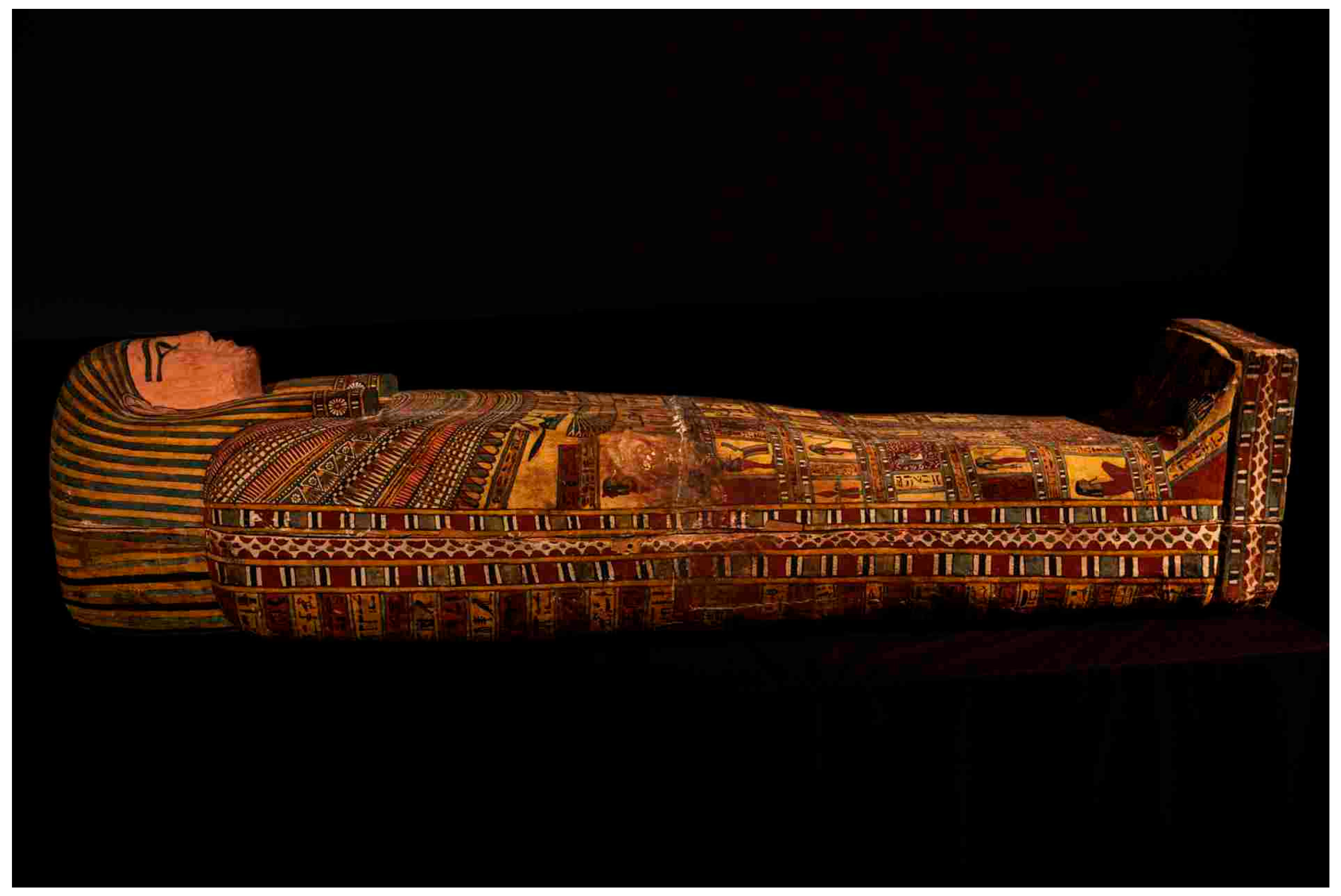
This paper attempts to establish the likely provenience for a looted Saite- Early Ptolemaic period (ca., 664 BC–323 BC) tripartite coffin repatriated to Egypt in 2015 (Figure 1) and to establish methods to be replicated by other satellite remote sensing looting studies. For the 2016 Egypt looting project [26], compiling previous excavation and survey reports allowed us to calculate many temporal ranges for sites. We created a detailed database of all the looted and damaged sites from the open-access and high-resolution satellite imagery, including number of looting pits, type of damage to sites, and their date ranges. Some sites only had data from a limited time-period (a single dynasty or period), while others had multiple periods of occupation. This database is kept securely on a private server, accessible only by the author and project collaborators. It is being updated as new imagery becomes available. To protect those sites, and at the request of Egypt’s Ministry of Antiquities, it is not possible to share the database.
During a 2009 raid, US ICE agents found an Egyptian Saite Period sarcophagus, with $2.5 million total of antiquities seized from that location [28]. This case, called “Operation Mummy’s Curse”, began when Special Agent Brenton Easter of the U.S. Department of Homeland Security (DHS) discovered a known looted head of an Iraqi statue, owned by antiquities dealer Mousa “Morris” Khouli. Agent Easter noted additional unprovenanced antiquities for sale on the website of Windsor Antiquities (owned by Khouli) in New York. He examined Khouli’s import records and discovered dozens of antiquities with the United Arab Emirates noted as their origin. Easter visited his gallery and obtained a warrant after Khouli had explained he imported the Egyptian objects from UAE [29]. This violated the National Stolen Property Act [29], which states it is against the law to import cultural treasures in violation of that country’s heritage laws. In Egypt, it is illegal to export any treasures greater than 100 years of age, with all antiquities found after 1983 belonging to Egypt’s government. This applies to all current archaeological projects in Egypt, where special permits must be obtained to take any samples out of the country. Easter found the sarcophagus (part of the tripartite coffin) in Khouli’s garage. Additional finds included another sarcophagus, furniture, wooden boat models from the Middle Kingdom, as well as limestone figures.
Three other individuals faced charges: Salem Alshdaifat (a numismatics dealer); Ayman Ramadan (an antiquities dealer); and Joseph A. Lewis II, a pharmacy company CEO and well-known collector of butterflies and antiquities. They received the equivalent of a wrist slap: Alshdaifat had to pay a $1000 fine (after being accused of assisting transactions between overseas sellers and Khouli), and Lewis had all charges dismissed, despite paying $150,000 for the antiquities. Khouli got a year’s probation, 200 h of community service and half a year of house arrest [30]. No one charged with any Federal antiquities-related crime has gone to jail in the US since 2002, when a judge sentenced ancient art dealer Frederick Schultz to serve 33 months in federal prison [31]. Schultz claimed that as no one technically owned the antiquities in question, they could not be deemed stolen.
As part of National Geographic story on looting in Egypt [32], the author visited an ICE facility in New York, where she met with ICE agents working on the case and shared the preliminary results of the Egypt looting research project with them. During the process of artifact assessment, the author asked if a provisional provenience assignment based on the satellite survey data might assist with the case. A lack of probable cause for antiquities trafficking case will make prosecution unlikely in the first instance. While the establishment of probable cause does not guarantee a case will be heard in court, it at least will make prosecution more likely. Thus, the author developed this research project as a test case: Is it remotely possible to work backwards from a known looted object to a potential site of origin, as mapped from satellite imagery? The implications for a successful test would be significant for archaeologists conducting looting mapping projects across the MENA region, in China, Peru, Mongolia, and any other countries where site looting is clearly visible on high-resolution satellite data.
3. Results
Case Study: Operation Mummy’s Curse
The tripartite coffin of Shesep-amun-tayes-herit, “Mistress of the House” (a common ancient Egyptian title), looted from an as-yet unknown site in Egypt, can be dated stylistically to the Saite Period-early Ptolemaic Period. There are multiple parallels for this coffin type, with similar decoration and iconography [33]. The lid is shrine-shaped, typical of coffins from this period, with four posts for attached wooden ba-birds. The inner and outer coffins are made from wood, with the outer coffin being anthropoid in shape, with a striped wig and highly decorated collar. Hieroglyphic inscriptions appear on the front in a series of yellow and white lines. The inner coffin, plastered and painted, has elaborate decorations, with a yellow and blue-striped wig, and a collar with multicolored floral and bead details. Book of the Dead spells can be seen along the sides of the coffin. Agents did not recover any mummies with the sarcophagus, but some mummy wrapping remnants can be seen in the interior of the inner coffin.
The quality of the tripartite coffin set is equivalent in quality to any from this period on display in museum collections globally. It is not surprising that a collector like Joe Lewis would seek to add it to his collection. The colors are striking, and the attention to detail suggest that a master artisan and their associated workshop prepared this coffin set. Looking closely, especially in the tiny crevices around the inner coffin’s eyes, tiny silicate particles catch the light, suggesting a sandy primary deposition. Thus, the likeliest scenario is that this coffin comes from a desert site, free from potential groundwater contamination. In the Delta, while it is not unheard of to uncover coffins, the state of preservation is generally very poor. Even if this object had come from the Delta, looters would have likely attempted to clean it, leading to colors running or dirt being evident in some of the crevices. There is no apparent organic debris on any of the three coffins, with significant time spent by the author in their presence closely examining the coffins using a magnifying glass. The best-preserved objects from ancient Egypt typically come from desert sites. Thus, we have a tripartite coffin from the Saite Period-early Ptolemaic Period, coming from what appears to be a desert site.
Using our satellite database of 279 looted sites, we could then begin to narrow down potential areas for the coffins’ origins. It is noted that, should looters have obtained them from a rock-cut tomb, a tomb beneath a house, or a tomb connected to an already-exposed tomb excavated by archaeologists, it would not be possible to see those areas on satellite imagery. Typically, in ancient Egypt, cemeteries would be found along the desert edges, close to the settlements where the people had lived. Given the quality of the tripartite coffin, Shesep-amun-tayes-herit came from a wealthy family, with the ability to pay for a top artisan. They would have likely resided in or near a major urban center.
The looting likely occurred between 2005 and early 2009, given that the seizures of the pieces took place between September and November 2009. It is not known how long it takes for a looted piece to move from Egypt to the US, nor are the routes well-understood. According to informal discussions with antiquities officials, a piece can stay for years in Egypt before it is deemed safe to transport. Assuming a 2+ year wait, plus a year or more in-transit to foreign auction houses, 2005 would seem to be the earliest the piece could have been looted. Most of the looting documented on the satellite imagery took place from 2009 onward, following the global recession. Also, given the dramatic increase in site looting in 2011, this narrows down the potential sites from which the sarcophagus might have come. Thus, could the satellite imagery have documented this looting incident? During the Saite-Ptolemaic period 2500 years ago, many sarcophagi like this would have come from either subterranean or rock cut tombs. Satellites could document the former looting, but not the latter, unless the looters left significant debris. Thus, we require a search in our database of large desert cemeteries, with major looting prior to early 2009, visible on satellite imagery.
Does this tripartite coffin then represent an upper or lower Egyptian piece, and could it have undergone reuse and moved from its place of original deposition? With a reference to Amun, it certainly could come from the Luxor area, yet Amun represented a powerful god during the Saite Period, and names with Amun in them are not uncommon throughout Egypt. Thus, we rely on the name itself. The title “Mistress of the House” is common [34], but the name, Shesep-amun-tayes-herit, is not. Searches through ancient Egyptian coffin books did not yield any somewhat identical parallels.
It is not insignificant that a coffin with the exact same name, located in the Tampa Museum of Art (on loan from the Ransohoff family), is said to come from Abusir el Maleq: “polychrome wood sarcophagus of Shesep-amun-tayes-herit, provenance Abusir-el-Meleq, north of Saqqara, Egypt, 1000–300 BC. Private collection, Tampa, FL, on loan to the Tampa Museum of Art” [35]. The name is a perfect match, which suggests a similar point of origin for the tripartite coffin sarcophagus. The suggested date rages are broad, covering the end of the New Kingdom to the Ptolemaic Period. The sarcophagus does look more Saite Period-early Ptolemaic Period in date. The quality of this sarcophagus is excellent, but it is not nearly as high quality as the piece from this case. It was restored by Caryatid conservation and then put on display at the Tampa Museum of Art.
The provenances of pieces like this can be suspect, and should be questioned. Any student of Egyptology would know at first glance that this sarcophagus is not New Kingdom in origin. Perhaps along the way to the Tampa Museum individuals gave the sarcophagus a broader date range, but it is curious as to why the exact location of origin is shared. Additional information about the sarcophagus is currently being sought. If the piece truly does come from Abusir el Malik, then the original acquisition information can be combined with the satellite data to determine when it may have been taken from Egypt. This represents a new tool for provenance researchers, and can be used in nearly every instance where there is clear satellite data alongside acquisition information.
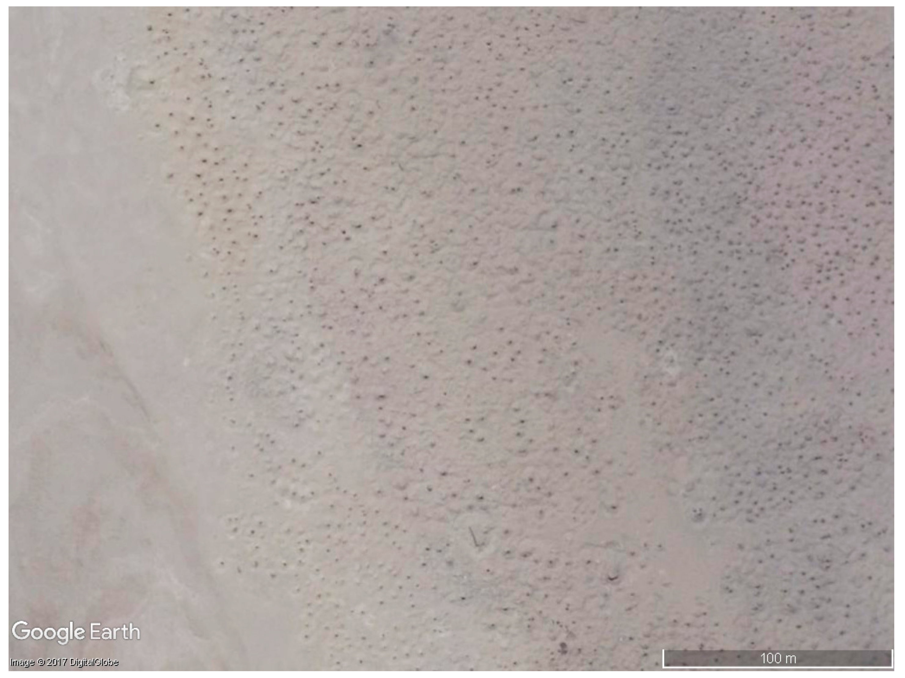
Abusir el Malik represents one of the worst-looted cemeteries from ancient Egypt (Figure 2), next to a settlement dating from the New Kingdom to the Roman Period. Satellite images show a cratered moonscape covered by thousands of looting holes. In a satellite image from 2004, the earliest date for which there is high resolution satellite data of the site, there were an apparent 6682 looting pits. The number dropped to 1530 in 2009, with many holes filling in, but jumped again to 4546 in 2010. For the 2016 study, the team analyzed each high-resolution satellite image (either Quickbird, WorldView-2, or Worldview-3 imagery), drawing a polygon around each looting pit or affected site area. We repeated this for each year where open pits were visible on imagery for each individual site [26].
Each pit may not in fact represent a single tomb, since shaft tombs in ancient Egypt can be for family groups or reused over time by non-family members. For example, at Lisht, a single tomb shaft can have upwards of 10 individual burials. This may explain why looters reopened some holes from earlier digging. We do not know when the intensive looting at Abusir el Malik began, as anecdotal evidence from local villagers suggests the looting has gone on for decades. It is not well-guarded, with new pits appearing in 2017 satellite imagery, and over 37 square hectares of total affected area.
Further research on the name of the individual on the tripartite coffin yielded a statue of interest from the Griffiths Institute [36], a block statuette of an individual named Nasekheperen-sekhmet-na-sheperen-shemt (note: name transliterated for the purposes of this article). This person’s mother had the name of Shesep-amun-tayes-herit, identical to the “Mummy’s Curse” lady. The individual served as a Vizier, second in charge of Egypt after Pharaoh. The head on the statue is modern, with the statue carved in greywacke (an extremely dense stone), and there are cartouches of Psamtik 1 (664–610 BC), with notes stating the statue is said to have come from Saqqara [37]. Could this then be the son of the original owner of the recovered sarcophagus? It is possible they may come from the same family, especially since the piece may have come from Saqqara, just north of Abusir el Malik, and it is the only other known instance of the name of the tripartite coffin owner, save the Tampa piece, which states clearly it has a provenience of Abusir el Malik (which also draws into question if the Tampa piece is looted). The Tampa piece represents a vital clue, given its state of preservation and data, showing that, at the very least, it comes from a desert cemetery site of the same date range as the “Mummy’s Curse” lady. This block statue may come from several hundred years before our lady lived, but it is only the 2nd known instance of this name, from a wealthy and powerful family, as only the wealthiest of families could have afforded such a coffin. Also, we can posit that the Mistress of the House Shesep-amun-tayes-herit was respected enough for her family to have ensured such a high-quality coffin, and it may or may not have been made before she died. We have no information about the additional items in her tomb, but we can assume that it would have represented a high-status burial, and would have contained numerous tomb goods like ushabitis, linens, pottery, offerings, jewelry, and other items.
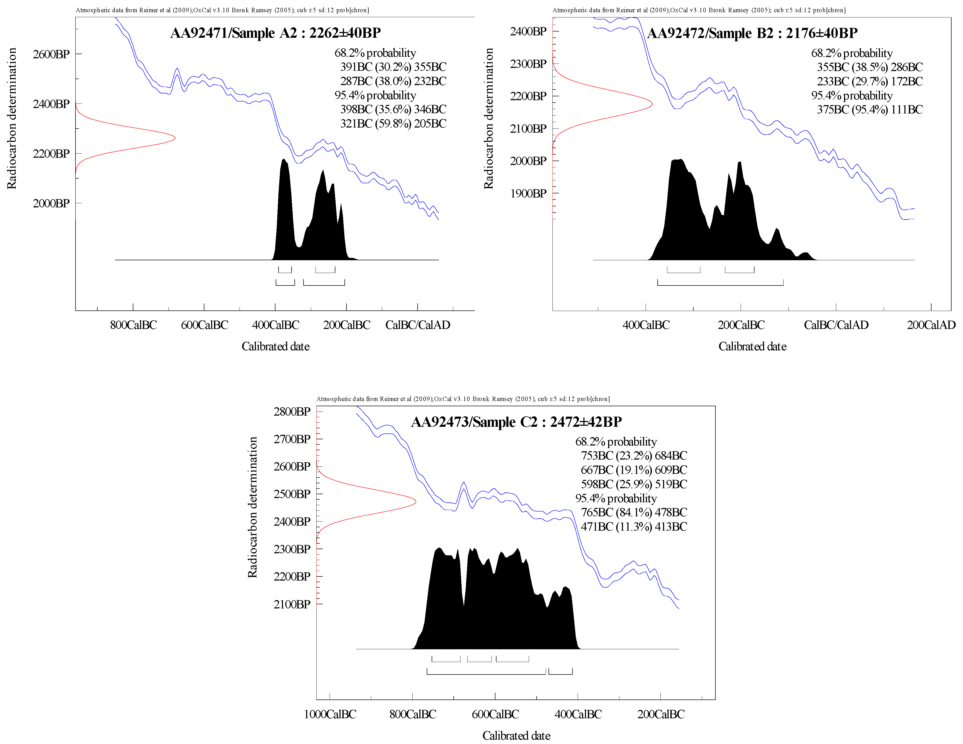
To determine the authenticity of the tripartite coffin, ICE, in collaboration with the University of Arizona, had it radiocarbon dated with a sample from each of the coffins [38] (Figure 3). It is not known which of the following dates correspond to which coffins, but each provides a calibrated date range. Reuse of older wood was common in ancient Egypt, so the one earlier date rage is not surprising. Sample A2 had a 95.4% probability of dating between 398 and 346 BC (35.6%) and 321 BC and 205 BC (59.8%). Sample B2 has a 95.4% probability of dating between 375 BC and 111 BC. Sample C2 dates to a bit earlier, with a 95.4% probability of a range between 765 BC and 478 BC (84.1%) and 471 BC and 413 BC (11.3%). Giving the highest probability date ranges a halfway point, we have 283 BC for sample A, 245 BC for sample B, and 622 BC for sample C. Samples A2 and B2 have a high probability of dating in the reign of Ptolemy II Philadelphus (283 BC–246 BC) and the start of the rule of Ptolemy III Euergetes (246 BC–221 BC). Sample C2 has a midway high probability of dating in the reign of Psamtik I (664 BC–602 BC) of Dynasty 26, which is the same date as the Vizier with an occurrence of the “Mummy’s Curse” lady’s name. Thus, there is a high probability that the tripartite coffin dates to the early part of the Ptolemaic Period, as suggested by its style, with potential reused material from Dynasty 26.
Abusir el Malik thus represents the most intensely looted desert cemetery dating to the Late Period-early Ptolemaic Period in the 2004–2009 period in the Saqqara region, with a long history of looting at the site. It has never been a well-guarded site, unlike Abusir or Saqqara, which did not experience intense looting until following the Arab Spring in 2011. It represents a smoking gun for the most likely place of origin for the sarcophagus in the ICE case. Regarding the Tampa Museum piece, its very provenance brings into question its legal status.
Could this tripartite coffin have come from any other sites? We will never know for sure, until geochemical testing for object provenience becomes standardized. Also, interviews with locals might provide confirmation if they remember the piece in question. At the very least, based on the tripartite coffin date, preservation, and silicates, we know it comes from an elite Saite-early Ptolemaic desert site, and looters removed it prior to 2009. Thus, do other sites from the database of 279 sites fit the bill as a possible site of origin? There are 43 looted sites (including Abusir el Malik) that have Late Period remains, 33 of which have both Late Period and Ptolemaic Period remains. There are 25 additional sites that have Ptolemaic Period remains (and earlier/later remains, but no noted Late Period remains). Of those Late Period/Ptolemaic sites, nine are desert cemetery sites (Abusir el Malik, Abydos, Atfih, Gebelein, Nag el-Deir, Qift, Sidment el-Gebel, Thebes, Tuna el-Gebel). Of the 25 Ptolemaic Period sites, one is a desert site (Gurob). Of those nine Late Period/Ptolemaic sites, three had clear evidence of looting prior to 2009 (Atfih, with mainly filled in older pits and 15 open pits in 2004; Sidment el-Gebel, with 357 pits in 2002, and Thebes, with 28 pits in 2005), with ambiguous data from Tuna el-Gebel (filled in earlier looting pits). Gurob has 798 open pits from 2008.
Could any of these be a stronger candidate than Abusir el Malik for the location of our tripartite coffin? Thebes and Atfih are easy to rule out, given the low number of looting pits in relationship to the other sites, and it is likely that the looting pits observed at Thebes had tombs containing material culture mainly from the New Kingdom. Tuna el-Gebel’s data is simply unclear. Thus, we are left with Gurob and Sidment el-Gebel as the main competitors, with clear open looting pits in 2002 and 2008, respectively. Located near the entrance to the Fayoum, each site is not near a major Late Period population center, unlike Abusir el Malik. Gurob has extensive New Kingdom remains as well, making it an attractive site for looters. We are left with Abusir al-Malik as our strongest candidate based on the looting database and other evidence.
4. Discussion
This research represents a test case of determining the provenance of a single object (or objects in association with one another) from satellite imagery and additional Egyptological research. Until a definitive soil and geological database exists for every known archaeological site in Egypt, testing samples from objects will not be possible. This additional technique may produce multiple results: the original site of deposition, where the object may have been moved to in antiquity, and the multiple sites where looters may have stored it in more recent times. ICE and other enforcement and policing organizations like it will have the specific entry port data for the object(s) in question. Objects typically take time to leave a country, so it is logical to assume the looters removed the object(s) in question a minimum of a year earlier. If the satellite data is good, with multiple images per year, archaeologists can determine when looting accelerated at a site.
In some cases, looters target high-value goods from elite tombs at specific sites. Lisht is one example. There are likely to 5000+ individual tombs at Lisht, with many partially-complete and intact ones based on the Joint Lisht Mission’s survey efforts [39]. A majority of Middle Kingdom material culture for sale today in auction houses or online globally likely came from Lisht from 2011 onwards. Given the satellite looting data and the types of objects to come from the site previously, a strong case could be made for the repatriation of said items. There are other sites like Lisht in Egypt that have cemeteries from a specific time-period, but most sites have multiple time periods.
Not all looting can be mapped with satellite data. Pits need to be clear enough to be detected from space, and if they are not, drones may be the best option. With many security and other restrictions in place, drone mapping is not easily feasible in countries like Egypt, and is best done for focused single region-only studies. Open-access data provides the best information for longitudinal studies, but the higher resolution imagery on Google Earth may not be up to date, missing key years, or may simply not even exist in some areas. Access to raw satellite data and the costs associated with it may be prohibitive for many teams working in heavily looted regions [39].
There are also numerous ethical issues associated with looting mapping that have yet escaped academic debate. The first is data sharing. How should academics share looting data with one another, and with the country where the looting has taken place? While an individual may show great care in storing data securely, with multiple copies around, there could easily be a security breach. Cultural ministries have their own diverse data storage policies, and may or may not be running up to date security software. A good alternative is to have all data hosted on a secure server, with restricted log-ins that can be tracked and monitored, so all parties involved can have equal and appropriate access (or perhaps access only to necessary data). The second major issue is the involvement of local people with ground confirmation of looting or site damage in times of war. If the individuals are doing this of their own free will, and sharing the information openly on blogs or social media, that is one matter. If a foreign project specifically asks individuals to input data, and these data are not anonymized, then the foreign individuals could be at enormous risk, either in their own country, or internationally, where these data may be used in courts of law. In these cases, and any cases that involve formalized interviewing of subjects, IRB (Institutional Review Board) approval must be gained. This ensures that ethical standards and protocols are followed when dealing with human subjects.
Looting is, of course, a complex topic. While archaeologists can map looting from satellite imagery, it is not possible to distinguish the types of looting taking place, or indeed the actors behind the looting. In the region of Lisht, where the author runs her joint mission with Egypt’s Ministry of Antiquities, there are multiple communities near archaeological sites. The author has learned through informal dialogue with people of the region that two types of looting occur on archaeological sites in Egypt. The first involves the community looting as a collective, where men will band together and focus on a tomb or series of tombs. They agree beforehand to loot and share the profits equally. The second type of looting is more nefarious, and fits with the “standard” type of looting most people assume takes place across Egypt: Gangs of men gather and dig illegally, and are paid either per tomb or per night, with bonuses associated with major discoveries. They are controlled by a mafioso-type leader, who organizes the hiding of the discoveries and delivery to middle men involved with shipments overseas. In the first instance, these individuals may live next to ancient sites. They do not feel connected to the sites, even though they may see them every day. Thus, they experience no shame when looting. This underlies the importance of local archaeological engagement with towns next to sites to prevent or reduce long-term site looting, far beyond the mere hiring of local workmen. Many projects are taking this approach in Egypt and elsewhere, but more must be done.
The narrative about when and where looting took place also needs to change. The standard story is that looting worsened after the Arab spring across the MENA region. Although archaeologists completed remote sensing work mapping looting in Iraq prior to 2011, we simply do not know the scale of looting in Syria before the Arab Spring. Understanding how, why, and where looting occurred will be crucial in connecting it to larger patterns. This will also help archaeologists understand the types of objects looted from sites, and when they might have entered the European or U.S. markets.
Future efforts with provenance research and tracking objects should incorporate satellite looting data, even if there is a list of more than one potential site from which an object may have originated. Egypt’s Recovery and Repatriation Unit has a list of unprovenanced objects in the many thousands that come from busts in Egypt or from objects recovered abroad. This author has shared her looting database with them in the hope that we can begin to piece together potential origin places for even a small fraction of the objects. Satellite data has an obvious place within traditional provenance research and can aid in the process of narrowing down the original location of objects. It also can help law enforcement investigation, suggesting when pieces may have been removed from countries initially. Best practices for this type of activity will eventually be established.
Using satellite data, auction houses could determine risk for any objects for sale after cross-referencing to a worldwide looting database. Why would they not wish to take the same care with determining whether a piece was “clean” (i.e., not looted) as they take with determining artifact authenticity? This could ultimately increase the value of non-looted antiquities for sale, representing good business practice.
5. Conclusions
Looting continues, unabated, across the globe, and urgent attention needs to be given to the issue before many sites are mostly destroyed above ground. Regulating the market presents an enormous challenge with diverse stakeholders [40,41]. Illegal quarrying and unchecked development represent two major threats to sites in Egypt at present, especially in the Dashur and Lisht regions, where illegal quarrying has increased 29,700% percent over time, with hundreds of tombs and even a potential pyramid destroyed [42]. Massive population growth has fueled the need for additional construction materials. This unchecked development, whether in the form of site destruction or encroachment, is of greater risk to sites versus looting. Large fences are not the answer: We simply do not know where all the sites are to protect, or even the limits of their boundaries. We know objects from these sites leave countries, but the timelines and routes they take to western markets are simply not well understood [43], and the laws can be ambiguous [44]. The first step to reducing and ideally stopping looting is the development of a worldwide site looting database. With advents in machine learning, the open-accessibility of new satellite datasets, and crowdsourcing it may be possible to have this database within the next 10 years. Once methods are in place to connect looted sites with objects and the dates those objects may have been removed from countries, an important threshold will be crossed in discouraging their removal in the first place. The antiquities market should be put on notice.
Acknowledgments
Funding support for this research came from the National Geographic Society; The National Science Foundation, and private donors. Special thanks to Egypt’s Ministry of Antiquities for their ongoing support of the author’s Joint Lisht Mission, especially Minister of Antiquities Khaled el Anany, Aynman Eshmawy, Mohammed el Badaie, Mohammed Ismail, Adel Okasha, and Sharif Abd el Monaem.
Conflicts of Interest
Sarah Parcak is President of the Board of Globalxplorer. She is also an archaeology Fellow with the National Geographic Society.
References
- Brodie, N.; Renfrew, C. Looting and the world’s archaeological heritage: The inadequate response. Ann. Rev. Anthropol. 2005, 34, 343–361. [Google Scholar] [CrossRef]
- Proulx, B. Archaeological site looting in ‘glocal’ perspective: Nature, scope, and frequency. Am. J. Archaeol. 2013, 117, 111–125. [Google Scholar] [CrossRef]
- Parcak, S. Going, going, gone: Towards a satellite remote-sensing methodology for monitoring archaeological tell sites under threat in the Middle East. J. Field Archaeol. 2007, 42, 61–83. [Google Scholar]
- Stone, E. Patterns of looting in southern Iraq. Antiquity 2008, 82, 125–138. [Google Scholar] [CrossRef]
- Hritz, C. Remote sensing of cultural heritage in Iraq: A case study of Isin. TAARII Newslett. 2008, 3, 1–8. [Google Scholar]
- Thomas, D.; Kidd, C.; Nikolovski, F.; Zipfel, C. The archaeological sites of Afghanistan in Google Earth. Aer. Archaeol. Res. Group News 2008, 37, 22–30. [Google Scholar]
- Contreras, D.; Brodie, N. The utility of publicly available satellite imagery for investigating looting of archaeological sites in Jordan. J. Field Archaeol. 2010, 35, 101–114. [Google Scholar] [CrossRef]
- Brodie, N.; Contreras, D. The economics of the looted archaeological site of Bâb edh-Dhrâ’: A view from Google Earth. In All the King’s Horses: Looting, Antiquities Trafficking and the Integrity of the Archaeological Record; Lazrus, P.K., Barker, A.W., Eds.; Society for American Archaeology: Washington, DC, USA, 2012. [Google Scholar]
- Coluzzi, R.; Lasaponara, R.; Masini, N. Satellite Imagery Time Series for the Detection of Looting Activities at Archaeological Sites; CNR-IMAA; EGU General Assembly: Vienna, Austria, 2010; p. 10569. [Google Scholar]
- Contreras, D. Huaqueros and remote-sensing imagery: Assessing looting damage in the Virú Valley, Peru. Antiquity 2010, 84, 544–555. [Google Scholar] [CrossRef]
- Tapete, D.; Cigna, F.; Donoghue, D. Looting marks’ in space-borne SAR imagery: Measuring rates of archaeological looting in Apamea (Syria) with TerraSAR-X Staring Spotlight. Remote Sens. Environ. 2016, 178, 42–58. [Google Scholar] [CrossRef]
- Hesse, R. Combining structure-from-motion with high- and intermediate-resolution satellite images to document threats to archaeological heritage in arid environments. J. Cult. Herit. 2015, 16, 192–201. [Google Scholar] [CrossRef]
- Morehart, C.; Millhauser, J. Monitoring cultural landscapes from space: Evaluating archaeological sites in the Basin of Mexico using very high resolution satellite imagery. J. Archaeol. Sci. Rep. 2016, 10, 363–376. [Google Scholar] [CrossRef]
- Agapiou, A.; Lysandrou, V.; Diofantos, G. Hadjimitsis, Optical Remote Sensing Potentials for Looting Detection. Geosciences 2017, 7, 98. [Google Scholar] [CrossRef]
- Kersel, M.; Hill, A. Aerial innovations: Using drones to document looting. Orient. Inst. News Notes 2015, 224, 8–9. [Google Scholar]
- Bjørgo, E.; Boccardi, G.; Cunliffe, E.; Fiol, M.; Jellison, T.; Pedersen, W.; Saslow, C. Satellite-Based Damage Assessment to Cultural Heritage Sites in Syria; United Nations Institute for Training and Research: Geneva, Switzerland, 2014; Available online: http://www.unitar.org/unosat/chs-syria (accessed on 26 October 2017).
- Wolfinbarger, S.; Drake, J.; Ashcroft, E.; Hanson, K. Ancient History, Modern Destruction: Assessing the Current Status of Syria’s World Heritage Sites Using High-Resolution Satellite Imagery. 2014. Available online: http://www.aaas.org/page/ancient-history-modern-destruction-assessing-current-status-syria-s-world-heritage-sites-using (accessed on 2 October 2017).
- Rayne, L.; Bradbury, J.; Mattingly, D.; Philip, G.; Bewley, R.; Wilson, A. From Above and on the Ground: Geospatial Methods for Recording Endangered Archaeology in the Middle East and North Africa. Geosciences 2017, 7, 100. [Google Scholar] [CrossRef]
- Casana, J.; Panahipour, N. Notes on a disappearing past: Satellite-based monitoring of looting and damage to archaeological sites in Syria. J. East. Mediterr. Herit. Stud. 2014, 128–151. [Google Scholar] [CrossRef]
- Danti, M.; Branting, S.; Penacho, S. The American Schools of Oriental Research Cultural Heritage Initiatives: Monitoring Cultural Heritage in Syria and Northern Iraq by Geospatial Imagery. Geosciences 2017, 7, 95. [Google Scholar] [CrossRef]
- Al Quntar, S.; Hanson, K.; Daniels, B.; Wegener, C. Responding to a cultural heritage crisis: The example of the Safeguarding the Heritage of Syria and Iraq Project. Near East. Archaeol. 2015, 78, 154–160. [Google Scholar] [CrossRef]
- Bowden, E.; Tofel, B.; Parcak, S.; Granger, R. Algorithmic Identification of Looted Archeological Sites from Space. Front. ICT 2017. [Google Scholar] [CrossRef]
- Anonymous. Secretary Kerry Signs Cultural Property Protection Agreement with Egypt. Available online: https://2009-2017.state.gov/r/pa/prs/ps/2016/11/264632.htm (accessed on 26 October 2017).
- Anonymous. H.R.1493—Protect and Preserve International Cultural Property Act. Available online: https://www.congress.gov/bill/114th-congress/house-bill/1493/text (accessed on 28 October 2017).
- Parcak, S.; Childs, C.; Mumford, G. Using satellite data vs. ground based remote sensing: An assessment, with case studies from Egypt’s Delta. Geosciences 2017, 7, 94. [Google Scholar] [CrossRef]
- Parcak, S.; Gathings, D.; Childs, C.; Mumford, G.; Cline, E. Satellite Evidence of Archaeological Site Looting in Egypt: 2002–2013. Antiquity 2016, 90, 188–205. [Google Scholar] [CrossRef]
- International Council of Museums (ICOM). ICOM Publishes a New Emergency Red List: The Emergency Red List of Egyptian Cultural Objects at Risk; International Council of Museums (ICOM): Paris, France, 2012. [Google Scholar]
- Lewis, D. How “Operation Mummy’s Curse” is Helping Fight Terrorism. Smithsonian Magazine. 2015. Available online: https://www.smithsonianmag.com/smart-news/federal-agents-are-fighting-terrorism-tracking-down-missing-mummies-180955113/ (accessed on 28 October 2017).
- Caulderwood, K. US Returns $2.5M In Egyptian Antiquities As Experts Call For Tougher Punishment on Smugglers. 2015. Available online: http://www.ibtimes.com/us-returns-25m-egyptian-antiquities-experts-call-tougher-punishment-smugglers-1892622 (accessed on 28 October 2017).
- Anonymous. 18 U.S. Code § 2315—Sale or Receipt of Stolen Goods, Securities, Moneys, or Fraudulent State Tax Stamps. Available online: https://www.law.cornell.edu/uscode/text/18/2315 (accessed on 28 October 2017).
- United States Court of Appeals, Second Circuit. United States of America, Appellee, V. Frederick SCHULTZ, Defendant-Appellant. Available online: http://caselaw.findlaw.com/us-2nd-circuit/1456261.html (accessed on 28 October 2017).
- Moeller, T. How Tomb Raiders Are Stealing Our History. National Geographic Magazine, 2016. Available online: https://www.nationalgeographic.com/magazine/2016/06/looting-ancient-blood-antiquities/ (accessed on 28 October 2017).
- Silverman, D.; Houser, J. Unpublished Report on the Tripartite Coffin Set; Penn Museum; University of Pennsylvania Museum: Philadelphia, PA, USA.
- Robins, G. Women in Ancient Egypt; Harvard University Press: Cambridge, MA, USA, 1993. [Google Scholar]
- Ancient Art. Available online: https://caryatidconservation.sharepoint.com/Pages/ancient.aspx (accessed on 28 October 2017).
- Malek, J.; Magee, D.; Miles, E. Topographical Bibliography of Ancient Egyptian Hieroglyphic Texts, Statues, Reliefs and Paintings. Volume VIII: Objects of Provenance Not Known: Statues; Peeters: Leuven, Belgium, 1999; pp. 846–847. [Google Scholar]
- Moret, A. Sarcophages de L’époque Bubastite à L’époque Saïte; Institut Français D’archéologie Orientale du Caire: Cairo, Egypt, 1913. [Google Scholar]
- Hodgkins, G. Report on the Radiocarbon Dates for the Mummy’s Curse Case; Department of Anthropology, University of Arizona: Tucson, AZ, USA, Unpublished work; 2017. [Google Scholar]
- Parcak, S. Archaeological looting in Egypt: A geospatial View (case studies from Saqqara, Lisht, and el Hibeh). Near East. Archaeol. 2015, 78, 196–203. [Google Scholar] [CrossRef]
- Nikolentzos, K.; Voutsa, K.; Koutsothanasis, C. What Does It Take to Protect Cultural Property? Some Aspects on the Fight against Illegal Trade of Cultural Goods from the Greek Point of View. Int. J. Cult. Prop. 2017, 24, 351–376. [Google Scholar] [CrossRef]
- Gerstenblith, P. Controlling the international market in antiquities: Reducing the harm, preserving the past. Chic. J. Int. Law 2007, 8, 167–185. [Google Scholar]
- Parcak, S. Threats to the archaeological sites of Egypt: A response to Fradley and Sheldrick. Antiquity 2017, 91, 782–792. [Google Scholar] [CrossRef]
- Kerselm, M. Transcending borders: Objects on the move. Archaeologies 2007, 3, 81–98. [Google Scholar] [CrossRef]
- Brodiem, N.; Tubbm, K. Illicit Antiquities: The Theft of Culture and the Extinction of Archaeology; Routledge: London, UK, 2001. [Google Scholar]
Figure 1.
The mummy of the lady Shesep-amun-tayes-herit. Imagery courtesy Rebecca Hale, National Geographic.
Figure 1.
The mummy of the lady Shesep-amun-tayes-herit. Imagery courtesy Rebecca Hale, National Geographic.

Figure 2.
Satellite image of Abusir el Malik, taken 8 August 2017. Imagery courtesy of Google Earth.
Figure 2.
Satellite image of Abusir el Malik, taken 8 August 2017. Imagery courtesy of Google Earth.

Figure 3.
Calibrated radiocarbon dates from the tripartite coffins. Images courtesy University of Arizona, Department of Anthropology.
Figure 3.
Calibrated radiocarbon dates from the tripartite coffins. Images courtesy University of Arizona, Department of Anthropology.

© 2017 by the author. Licensee MDPI, Basel, Switzerland. This article is an open access article distributed under the terms and conditions of the Creative Commons Attribution (CC BY) license (http://creativecommons.org/licenses/by/4.0/).
Share and Cite
MDPI and ACS Style
Parcak, S. Moving from Space-Based to Ground-Based Solutions in Remote Sensing for Archaeological Heritage: A Case Study from Egypt. Remote Sens. 2017, 9, 1297. https://doi.org/10.3390/rs9121297
AMA Style
Parcak S. Moving from Space-Based to Ground-Based Solutions in Remote Sensing for Archaeological Heritage: A Case Study from Egypt. Remote Sensing. 2017; 9(12):1297. https://doi.org/10.3390/rs9121297
Chicago/Turabian StyleParcak, Sarah. 2017. "Moving from Space-Based to Ground-Based Solutions in Remote Sensing for Archaeological Heritage: A Case Study from Egypt" Remote Sensing 9, no. 12: 1297. https://doi.org/10.3390/rs9121297
Note that from the first issue of 2016, this journal uses article numbers instead of page numbers. See further details here.