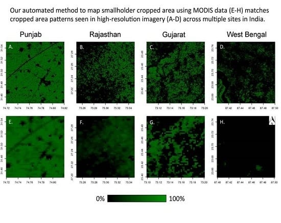
An Automated Approach to Map Winter Cropped Area of Smallholder Farms across Large Scales Using MODIS Imagery
Abstract
:1. Introduction
2. Study Area
3. Data and Methods
3.1. Data
3.2. Method
3.3. High-Resolution Imagery Validation
3.4. Additional Comparisons
4. Results
4.1. High-Resolution Imagery Validation
4.2. Additional Comparisons
5. Discussion
6. Conclusions
Supplementary Materials
Acknowledgments
Author Contributions
Conflicts of Interest
References
- DeFries, R.; Mondal, P.; Singh, D.; Agrawal, I.; Fanzo, J.; Remans, R.; Wood, S. Synergies and trade-offs for sustainable agriculture: Nutritional yields and climate-resilience for cereal crops in Central India. Glob. Food Secur. 2016, 11, 44–53. [Google Scholar] [CrossRef]
- Fishman, R. More uneven distributions overturn benefits of higher precipitation for crop yields. Environ. Res. Lett. 2016, 11, 024004. [Google Scholar] [CrossRef]
- Lobell, D.B.; Schlenker, W.; Costa-Roberts, J. Climate trends and global crop production since 1980. Science 2011, 333, 616–620. [Google Scholar] [CrossRef] [PubMed]
- Godfray, H.C.J.; Beddington, J.R.; Crute, I.R.; Haddad, L.; Lawrence, D.; Muir, J.F.; Pretty, J.; Robinson, S.; Thomas, S.M.; Toulmin, C. Food security: The challenge of feeding 9 billion people. Science 2010, 327, 812–818. [Google Scholar] [CrossRef] [PubMed]
- Ray, D.K.; Ramankutty, N.; Mueller, N.D.; West, P.C.; Foley, J.A. Recent patterns of crop yield growth and stagnation. Nat. Commun. 2012, 3, 1293. [Google Scholar] [CrossRef] [PubMed]
- Shanahan, J.F.; Schepers, J.S.; Francis, D.D.; Varvel, G.E.; Wilhelm, W.W.; Tringe, J.M.; Schlemmer, M.R.; Major, D.J. Use of remote-sensing imagery to estimate corn grain yield. Agron. J. 2001, 93, 583–589. [Google Scholar] [CrossRef]
- Quarmby, N.A.; Milnes, M.; Hindle, T.L.; Silleos, N. The use of multi-temporal NDVI measurements from AVHRR data for crop yield estimation and prediction. Int. J. Remote Sens. 1993, 14, 199–210. [Google Scholar] [CrossRef]
- Doraiswamy, P.C.; Sinclair, T.R.; Hollinger, S.; Akhmedov, B.; Stern, A.; Prueger, J. Application of MODIS derived parameters for regional crop yield assessment. Remote Sens. Environ. 2005, 97, 192–202. [Google Scholar] [CrossRef]
- Wardlow, B.D.; Egbert, S.L. Large-area crop mapping using time-series MODIS 250 m NDVI data: An assessment for the U.S. Central Great Plains. Remote Sens. Environ. 2008, 112, 1096–1116. [Google Scholar] [CrossRef]
- Morton, J.F. The impact of climate change on smallholder and subsistence agriculture. Proc. Natl. Acad. Sci. USA 2007, 104, 19680–19685. [Google Scholar] [CrossRef] [PubMed]
- Jain, M.; Mondal, P.; DeFries, R.S.; Small, C.; Galford, G.L. Mapping cropping intensity of smallholder farms: A comparison of methods using multiple sensors. Remote Sens. Environ. 2013, 134, 210–213. [Google Scholar] [CrossRef]
- Jain, M.; Srivastava, A.K.; Balwinder-Singh; Joon, R.K.; McDonald, A.; Royal, K.; Lisaius, M.C.; Lobell, D.B. Mapping smallholder wheat yields and sowing dates using micro-satellite data. Remote Sens. 2016, 8, 860. [Google Scholar] [CrossRef]
- Carletto, C.; Jolliffe, D.; Banerjee, R. The Emperor Has No Data! Agricultural Statistics in Sub-Saharan Africa; World Bank Working Paper; World Bank: Washington, DC, USA, 2013; Available online: http://mortenjerven.com/wp-content/uploads/2013/04/Panel-3-Carletto.pdf (accessed on 7 January 2016).
- Whitcraft, A.K.; Vermote, E.F.; Becker-Reshef, I.; Justice, C.O. Cloud cover throughout the agricultural growing season: Impacts on passive optical earth observations. Remote Sens. Environ. 2015, 156, 438–447. [Google Scholar] [CrossRef]
- Biradar, C.M.; Xiao, X. Quantifying the area and spatial distribution of double-and triple-cropping croplands in India with multi-temporal MODIS imagery in 2005. Int. J. Remote Sens. 2011, 32, 367–386. [Google Scholar] [CrossRef]
- Spera, S.A.; Cohn, A.S.; VanWey, L.K. Recent cropping frequency, expansion, and abandonment in Mato Grosso, Brazil had selective land characteristics. Environ. Res. Lett. 2014, 9, 064010. [Google Scholar] [CrossRef]
- Lesk, C.; Rowhani, P.; Ramankutty, N. Influence of extreme weather disasters on global crop production. Nature 2016, 529, 84–87. [Google Scholar] [CrossRef] [PubMed]
- Gajbhiye, K.S.; Mandal, C. Agro-Ecological Zones, Their Soil Resource and Cropping Systems; National Bureau of Soil Survey and Land Use Planning: Nagpur, India, 2000; Available online: http://www.indiawaterportal.org/sites/indiawaterportal.org/files/01jan00sfm1.pdf (accessed on 11 December 2016).
- Chand, R.; Lakshmi Prasanna, P.A.; Singh, A. Farm size and productivity: Understanding the strengths of smallholders and improving their livelihoods. Econ. Political Wkly. 2011, 46, 5–11. [Google Scholar]
- Lobell, D.B.; Burke, M.B.; Tebaldi, C.; Mastrandrea, M.D.; Falcon, W.P.; Naylor, R.L. Prioritizing climate change adaptation needs for food security in 2030. Science 2008, 319, 607–610. [Google Scholar] [CrossRef] [PubMed]
- Mall, R.K.; Singh, R.; Gupta, A.; Srinivasan, G.; Rathore, L.S. Impact of climate change on Indian agriculture: A review. Clim. Chang. 2006, 78, 445–478. [Google Scholar] [CrossRef]
- Erenstein, O.; Thorpe, W. Livelihoods and agro-ecological gradients: A meso-level analysis in the Indo-Gangetic Plains, India. Agric. Syst. 2011, 104, 42–53. [Google Scholar] [CrossRef]
- Jain, M.; Naeem, S.; Orlove, B.; Modi, V.; DeFries, R.S. Understanding the causes and consequences of differential decision-making in adaptation research: Adapting to a delayed monsoon onset in Gujarat, India. Glob. Environ. Chang. 2015, 31, 98–109. [Google Scholar] [CrossRef]
- Wardlow, B.; Egbert, S.; Kastens, J. Analysis of time-series MODIS 250 m vegetation index data for crop classification in the U.S. Central Great Plains. Remote Sens. Environ. 2007, 108, 290–310. [Google Scholar] [CrossRef]
- Sakamoto, T.; Wardlow, B.D.; Gitelson, A.A.; Verma, S.B.; Suyker, A.E.; Arkebauer, T.J. A Two-step filtering approach for detecting maize and soybean phenology with time-series MODIS data. Remote Sens. Environ. 2010, 114, 2146–2159. [Google Scholar] [CrossRef]
- National Food Security Mission Crop Calendar of NFSM Crops. Available online: http://nfsm.gov.in/nfmis/RPT/CalenderReport.aspx (accessed on 10 January 2017).
- Xiao, X.; Boles, S.; Liu, J.; Zhuang, D.; Frolking, S.; Li, C.; Salas, W.; Moore, B., III. Mapping paddy rice agriculture in southern China using multi-temporal MODIS images. Remote Sens. Environ. 2005, 95, 480–492. [Google Scholar] [CrossRef]
- Ren, J.; Chen, Z.; Zhou, Q.; Tang, H. Regional yield estimation for winter wheat with MODIS-NDVI data in Shandong, China. Int. J. Appl. Earth Obs. Geoinf. 2008, 10, 403–413. [Google Scholar] [CrossRef]
- Becker-Reshef, I.; Vermote, E.; Lindeman, M.; Justice, C. A generalized regression-based model for forecasting winter wheat yields in Kansas and Ukraine using MODIS data. Remote Sens. Environ. 2010, 114, 1312–1323. [Google Scholar] [CrossRef]
- O’Brien, K.; Leichenko, R.; Kelkar, U.; Venema, H.; Aandahl, G.; Tompkins, H.; Javed, A.; Bhadwal, S.; Barg, S.; Nygaard, L.; et al. Mapping vulnerability to multiple stressors: Climate change and globalization in India. Glob. Environ. Chang. 2004, 14, 303–313. [Google Scholar] [CrossRef]
- Shah, T. Crop per drop of diesel? Energy squeeze on India’s smallholder irrigation. Econ. Political Wkly. 2007, 42, 4002–4009. [Google Scholar]
- Division, A.I. District Wise Land Use Statistics. Available online: http://aps.dac.gov.in/APY/Index.htm (accessed on 10 January 2017).
- Directorate of Economics and Statistics Area Production Yield Dataset-District 2016. Available online: http://aps.dac.gov.in/APY/Public_Report1.aspx (accessed on 1 September 2016).
- Duncan, J.M.A.; Dash, J.; Atkinson, P.M. Elucidating the impact of temperature variability and extremes on cereal croplands through remote sensing. Glob. Chang. Biol. 2014, 21, 1541–1551. [Google Scholar] [CrossRef] [PubMed]
- Xiao, X.; Boles, S.; Frolking, S.; Li, C.; Babu, J.Y.; Salas, W.; Moore, B., III. Mapping paddy rice agriculture in South and Southeast Asia using multi-temporal MODIS images. Remote Sens. Environ. 2006, 100, 95–113. [Google Scholar] [CrossRef]
- Lobell, D.B.; Thau, D.; Seifert, C.; Engle, E.; Little, B. A scalable satellite-based crop yield mapper. Remote Sens. Environ. 2015, 164, 324–333. [Google Scholar] [CrossRef]
- Planet Team. Planet Application Program Interface: In Space for Life on Earth. San Francisco, CA, 2017. Available online: https://api.planet.com (accessed on 1 February 2017).
| Location | Image Date | Satellite | MSA R2 | MSA RMSE | Phenology Match |
|---|---|---|---|---|---|
| Rajasthan | 1-12-16 | RapidEye | 0.89 | 10.13 | Yes |
| Punjab | 1-31-11 | WorldView-2 | 0.78 | 7.75 | Yes |
| Uttar Pradesh 1 | 2-17-15 | RapidEye | 0.74 | 14.33 | Yes |
| Uttar Pradesh 2 | 2-15-15 | RapidEye | 0.72 | 13.18 | Yes |
| Bihar | 2-11-16 | SkySat | 0.73 | 22.14 | Yes |
| Haryana | 1-18-15 | RapidEye | 0.60 | 21.04 | Yes |
| Andhra Pradesh | 2-25-15 | RapidEye | 0.55 | 34.38 | No |
| Karnataka | 2-18-15 | RapidEye | 0.52 | 33.21 | No |
| Gujarat | 1-18-10 | WorldView-2 | 0.45 | 21.53 | Yes |
| Maharashtra | 2-17-15 | RapidEye | 0.41 | 30.02 | No |
| West Bengal | 1-12-08 | Quickbird | 0.19 | 27.87 | No |
| All 11 Sites | - | - | 0.71 | 18.47 | - |
| Sites with Phenology Match | - | - | 0.75 | 16.29 | - |
© 2017 by the authors. Licensee MDPI, Basel, Switzerland. This article is an open access article distributed under the terms and conditions of the Creative Commons Attribution (CC BY) license (http://creativecommons.org/licenses/by/4.0/).
Share and Cite
Jain, M.; Mondal, P.; Galford, G.L.; Fiske, G.; DeFries, R.S. An Automated Approach to Map Winter Cropped Area of Smallholder Farms across Large Scales Using MODIS Imagery. Remote Sens. 2017, 9, 566. https://doi.org/10.3390/rs9060566
Jain M, Mondal P, Galford GL, Fiske G, DeFries RS. An Automated Approach to Map Winter Cropped Area of Smallholder Farms across Large Scales Using MODIS Imagery. Remote Sensing. 2017; 9(6):566. https://doi.org/10.3390/rs9060566
Chicago/Turabian StyleJain, Meha, Pinki Mondal, Gillian L. Galford, Greg Fiske, and Ruth S. DeFries. 2017. "An Automated Approach to Map Winter Cropped Area of Smallholder Farms across Large Scales Using MODIS Imagery" Remote Sensing 9, no. 6: 566. https://doi.org/10.3390/rs9060566
APA StyleJain, M., Mondal, P., Galford, G. L., Fiske, G., & DeFries, R. S. (2017). An Automated Approach to Map Winter Cropped Area of Smallholder Farms across Large Scales Using MODIS Imagery. Remote Sensing, 9(6), 566. https://doi.org/10.3390/rs9060566


