1. Introduction
The Indo Gangetic Plain (IGP) is considered to be one of the most highly polluted regions of the world due to persistent heavy aerosol loading in its atmosphere [
1,
2]. Due to the high level of air pollution, premature mortality as a result of exposure to PM
2.5 in the Indian section of IGP alone is estimated to be 240,000 per annum [
3]. Krishna Moorthy et al. [
4] analysed the historical data from aerosol observatories in India and found that the aerosol optical depth (AOD) had increased at a rate of 2.3% (relative to 1985) per annum and the increasing trend was further increased (to 4%) in the last decade. High atmospheric pollution in this region is not only due to emissions from an increased use of fossil fuel in transportation and the industrial sector, but also due to a high dependence on biomass being used mainly for cooking in the residential sector [
5,
6]. In addition, the burning of crop residue (rice and wheat) in the field has significantly contributed to the high level of aerosols during the post monsoon and pre monsoon seasons in the IGP [
7,
8,
9,
10,
11]. Furthermore, the unique topographic features of the IGP with the Hindu Kush Himalayan range to the north, moderate hills in the south, Thar desert and Arabian sea to the west, and the Bay of Bengal to the east, in combination with rapidly increasing anthropogenic aerosol loading in the region and mineral dust from the Thar desert, has resulted in an alarming increase in aerosol loading in this region [
1]. Based upon the annual mean PM
2.5 concentration, 17 cities of the IGP were included in the 20 most polluted cities of the world [
12]. Given that all the representative concentration pathway (RCP) scenarios indicate that the air quality in this region is likely to degrade further. It is expected that severe negative effects on public health and the ecosystem will continue into the future [
13].
Along with the negative effects on public health, it is reported that the high level of atmospheric aerosols in the IGP has also affected natural systems significantly. Unlike other parts of the world, solar dimming is found to be continued in India even after 2000 [
14]. Similarly, while analyzing net downward shortwave radiation (NDSWR) over south Asia for the period of 1979–2004, it was found that solar dimming continues in south Asia with a trend of −0.54 W/m
2/year [
15]. Singh et al. [
16] analyzed the solar radiation and evaporation trends at four metrological stations in India during 1975–1995 and found solar diming in the range of 1.5% to 3.4% per decade across the stations. Similarly, it is reported that the net incoming radiation reduced by about 19% in the Indo Gangetic basin due to aerosols, which is expected to effect the regional climate significantly [
17]. The atmospheric brown cloud (ABC) over the north Indian Ocean and south Asia, due to anthropogenic atmospheric aerosols, was documented after the Indian Ocean Experiment (INDOEX) and several studies into its possible effects on regional and global climate [
18,
19,
20,
21,
22]. In the study of the IGP region using remote sensing techniques, Devara and Manoj [
23] concluded that there is strong association between atmospheric aerosol content and monsoon precipitation. Since the summer monsoon provides 75–90% of the annual rainfall in the IGP, the agricultural performance of this region is also expected to be affected by the high level of atmospheric aerosols.
Aerosols also have a significant effect on fog formation in the IGP region [
24]. Every winter, the whole IGP region is engulfed by dense fog with a significant increasing trend in the number of foggy days during the past 35 years [
25,
26]. The increasing trend of winter fog has not only affected day-to-day life of millions of people living in this region, through frequent flight/train delay due to poor visibility [
27], but it also negatively affected the production of several winter crops [
28,
29]. A statistical model of historical rice harvest in India, coupled with a regional climate scenario, indicated that there has been a slowdown in the increase in production over the last two decades due to increased brown cloud and greenhouse gas [
30]. Similarly, Latha et al. [
31] compared the radiative forcing of atmospheric black carbon at two locations in IGP, Varanasi and Ranchi by using Santa Barbara DISTORT Atmospheric Radiative Transfer (SBDART) model and concluded that the incoming radiation is reduced by about 5% due to black carbon (BC) during any time of day at Varanasi and 4% at Ranchi. This study also estimated the loss of wheat crop at Varanasi and Ranchi while using the empirical model that was developed by Ahmed and Hassen [
32] as −149 kg/ha and −141 kg/ha, respectively, due to the reduction of solar radiation because of atmospheric black carbon. Moreover, a crop response simulation model has shown that there is a direct relationship between the increase (decrease) in solar irradiance and increase (decrease) in rice and wheat yield in China and that due to atmospheric aerosols and regional haze there has been a reduction in wheat and rice yields in China by 5 to 30% [
33]. In this context, information on the effect of aerosols on solar radiation in the IGP is important not only to study the effect on the climate and ecosystem in the long run, but also to study the immediate effects of atmospheric aerosols on solar radiation availability for agricultural production in the region.
The effect of atmospheric aerosols on climate is generally measured in terms of aerosol radiative forcing, which is defined as the effect of anthropogenic aerosols on the radiative fluxes [
34]. The radiative forcing is estimated at the top of atmosphere (TOA), bottom of atmosphere (BOA), and in the atmosphere. Ramanathan & Ramana [
19] studied the direct radiative forcing of atmospheric brown clouds in the Himalayan foot hills and Indo Gangetic Plains (IGPs) by using MODIS Terra satellite data during 2001 to 2003 and found the average surface radiative forcing during the dry season (October to May) in the region is about −32 ± 5 Wm
−2. Similarly, Dey and Tripathi [
35] studied the direct radiative effect of aerosols in the IGP during 2001 to 2005 by using an aerosol optical model and found the annual average radiative forcing at the surface at Kanpur was −31.8 ± 10.9 Wm
−2. Their study also concluded that anthropogenic aerosols contributed 80% of the radiative forcing at Kanpur during October to February. Similarly, Ramachandran and Kedia [
36] investigated the seasonal variation of aerosol radiative forcing at Kanpur and Gandhi college during January 2006 to December 2007 by using AERONET data and the Santa Barbara DISORT Atmospheric Radiative Transfer (SBDART) model, which provided very similar results. The maximum radiative forcing in the atmosphere and at the surface was in the pre-monsoon season at both stations. Das et al. [
37] studied winter haze in the eastern Indo Gangetic Basin through ground measurements during December 2013 to February 2014 and the radiative effect of haze by using SBDART and found the radiative forcing at the BOA in Silguri, Kolkata and Sunderban was −39.3, −70.3 and −38 Wm
−2 respectively. In addition, Latha et al. [
31] studied the radiative forcing of atmospheric black carbon at Varanasi and Ranchi using SBDART and concluded that the radiative forcing due to atmospheric black carbon is significantly increased from February to March (i.e., from −30 Wm
−2 to −50 Wm
−2) at Varanasi due to an increased BC concentration and mixing layer height. The radiative forcing due to atmospheric aerosols at IGP stations has been studied at the annual, seasonal, and in some cases, monthly time scale by using radiative transfer models [
36,
38,
39,
40,
41,
42,
43,
44].
The Santa Barbara DISTORT Atmospheric Radiative Transfer (SBDART) model was developed to model the plane parallel radiative transfer within the atmosphere and at the earth surface [
45]. SBDART is a comprehensive model that consists of six standard atmospheric profiles, five basic surface types and four standard aerosol types, SBDART is widely used to study direct radiative forcing due to atmospheric aerosols at the earth surface, within the atmosphere and at the top of atmosphere [
38,
46,
47,
48]. However, it requires a large number of input parameters (and therefore assumptions) and high processing time, making it unrealistic for use with large amounts of data across spatial and temporal scales [
49]. In this context, there is a need for a simple model to determine radiative forcing across the IGP at daily time scale. Determination of the daily radiative forcing across the IGP may also help to determine the change in radiative flux due to atmospheric aerosols loading, and this could help to assess the effect of atmospheric aerosols on terrestrial ecosystems at the regional scale. In turn, this will help to investigate the effects of atmospheric aerosols on the crop production system at the regional level, as suggested by Huntingford et al. [
50].
We aimed to develop a simple regression model to determine daily radiative forcing from high quality station data in the IGP, which can then be driven by remotely sensed data (which has wide temporal and spatial coverage). Within the IGP, there are several AERONET (AErosol RObotic NETwork) stations that are part of the global network of ground based remote sensing aerosol stations initiated by National Aeronautics and Space Administration (NASA) [
51]. These stations provide continuous high-quality point observations of aerosol loading and radiative forcing due to atmospheric aerosols. Garcia et al. [
52] validated the AERONET estimated radiative forcing against ground based broad band measurements from the Baseline Surface Radiation (BSRN) and the Solar Radiation Networks (SolRad-Net), and found that AERONET estimated radiative forcing is very close to ground measurements with uncertainty less than 15 Wm
−2 for all stations, which is within the uncertainty of BSRN and SolRad-Net observed data. AERONET ground observation data are extensively used to study the optical properties of atmospheric aerosols and their radiative effects [
48,
53,
54,
55]. In addition, AERONET observations are also considered to be the benchmark for the validation of aerosol properties obtained from other indirect methods, such as models and satellite imagery. But, these point data on aerosol optical properties and radiative forcing due to atmospheric aerosols at the surface and top of atmosphere are limited to the location of the AERONET stations.
In this context, it is planned to develop and evaluate a multiple regression model to estimate daily radiative forcing at the bottom of the atmosphere in the IGP by using the quality AERONET station point data and spatially distributed satellite remotely sensed data in the region. Remer et al. [
56] extensively validated the Moderate Resolution Imaging Spectrometers (MODIS) retrieved AOD with AERONET measured AOD at the global scale and found that MODIS products are accurate within prelaunch expectations and they are sufficiently accurate for a variety of applications, including improved estimates of observationally based aerosol radiative effects. For the wide scale application of this simple regression model, it is evaluated by using MODIS derived aerosol properties at the AERONET stations located in IGP. After successful evaluation of the model with MODIS derived aerosol properties at AERONET stations in the IGP, this model can be used to estimate the radiative forcing due to atmospheric aerosols at the surface on any day at any location of the IGP because MODIS sensors on the Terra and Aqua earth observing system (EOS) satellites provide continuous and near real time aerosol properties of the earth at higher temporal and spatial resolutions. This model will help to estimate the reduction of solar radiation at the surface of the IGP, which may be utilised to study the immediate effects of aerosols in the IGP on, for example, crop production, evapotranspiration, etc., along with the long-term effects of aerosols on climate change and the natural systems of the IGP.
The important feature of this study is the development and evaluation of a simple regression model to estimate direct daily radiative forcing due to atmospheric aerosol (ADRF) in the IGP region by using point AERONET data. Once established, the model will be evaluated while using MODIS inputs at the AERONET stations, where AERONET ADRF is available. Using MODIS products of daily average AOD and precipitable water vapour in this model will allow, ADRF to be estimated at any location across the IGP. This simple model may be used to assess the effect of atmospheric aerosols on solar radiation, and consequently environmental effects at daily time scale in the IGP region.
5. Summary and Conclusions
The IGP region is considered to have an extremely high loading of atmospheric aerosols in the south Asian region [
97]. The high loading of atmospheric aerosols has not only negatively affected the public health and day to day life of people, but also the natural systems in the IGP. The ADRF is a measure to estimate the effect of atmospheric aerosols on the regional and global natural systems. Various studies indicate that there is a significant effect of atmospheric aerosols on solar radiation in the IGP. To estimate the ADRF at the BOA and TOA, radiative transfer models are used, and, among them, SBDART is found to be comprehensive and widely used. However, the complexity of SBDART, which requires more than 60 input parameters [
48] and high processing time, are limitations to wider use. To address these limitations, here we developed a simple year-round model to estimate the daily radiative forcing due to atmospheric aerosols (ADRF) at the surface of the IGP through multiple regressions of AERONET AOD, atmospheric water vapour, and the radiative forcing at the surface using data from 2002 to 2015 at 10 stations in the IGP. The goodness of fit of the developed ADRF model is indicated by the adjusted R
2 value of 0.834. The Jackknife method of delete one group (station data) was employed to study the stability of the model and the model was found to be robust because adjusted R
2 fluctuated between 0.813 and 0.842 and the standard error varied from 13.791 to 15.098. Station wise and season wise evaluations of the model were performed and found that the model performed well in all seasons and stations.
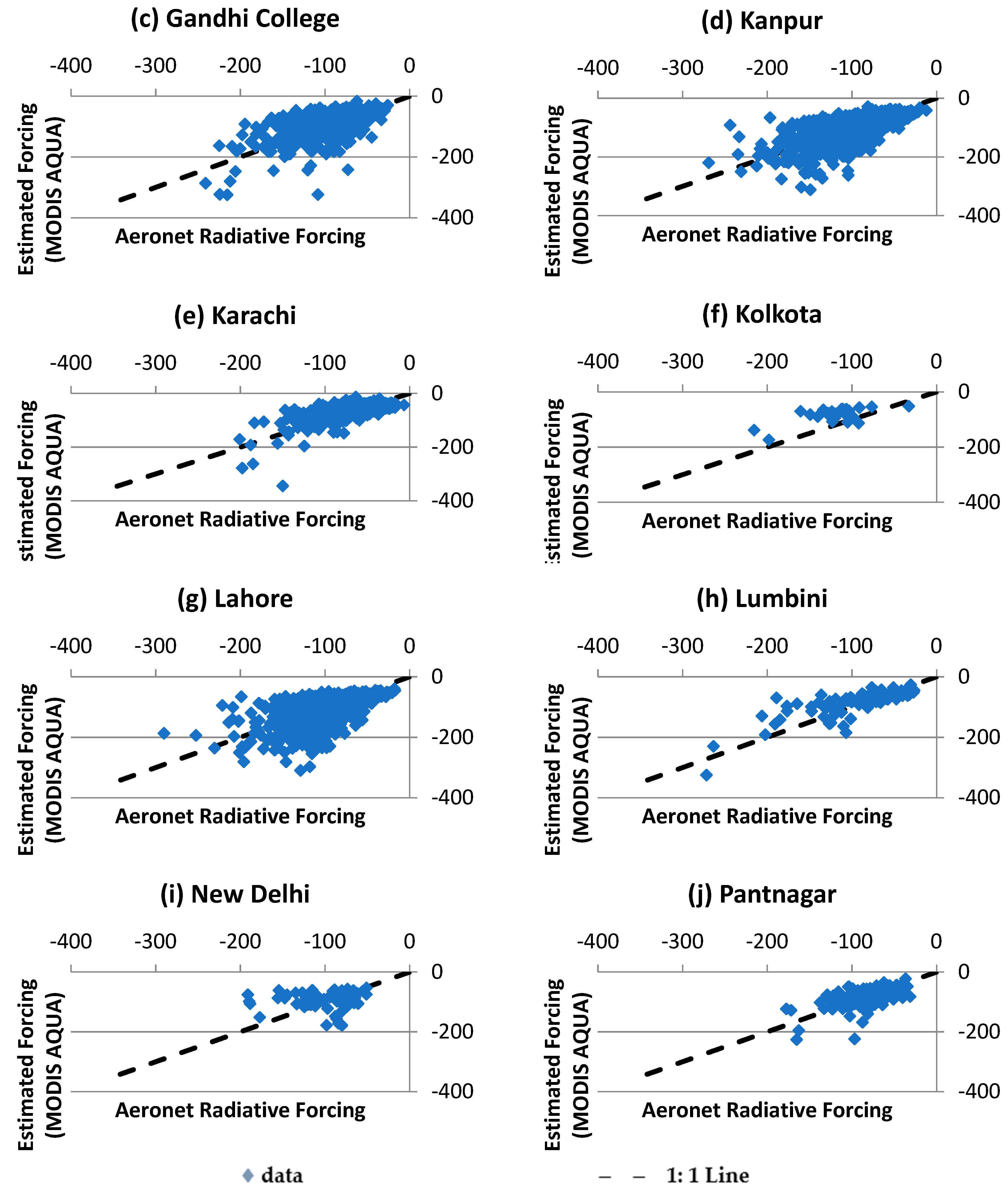
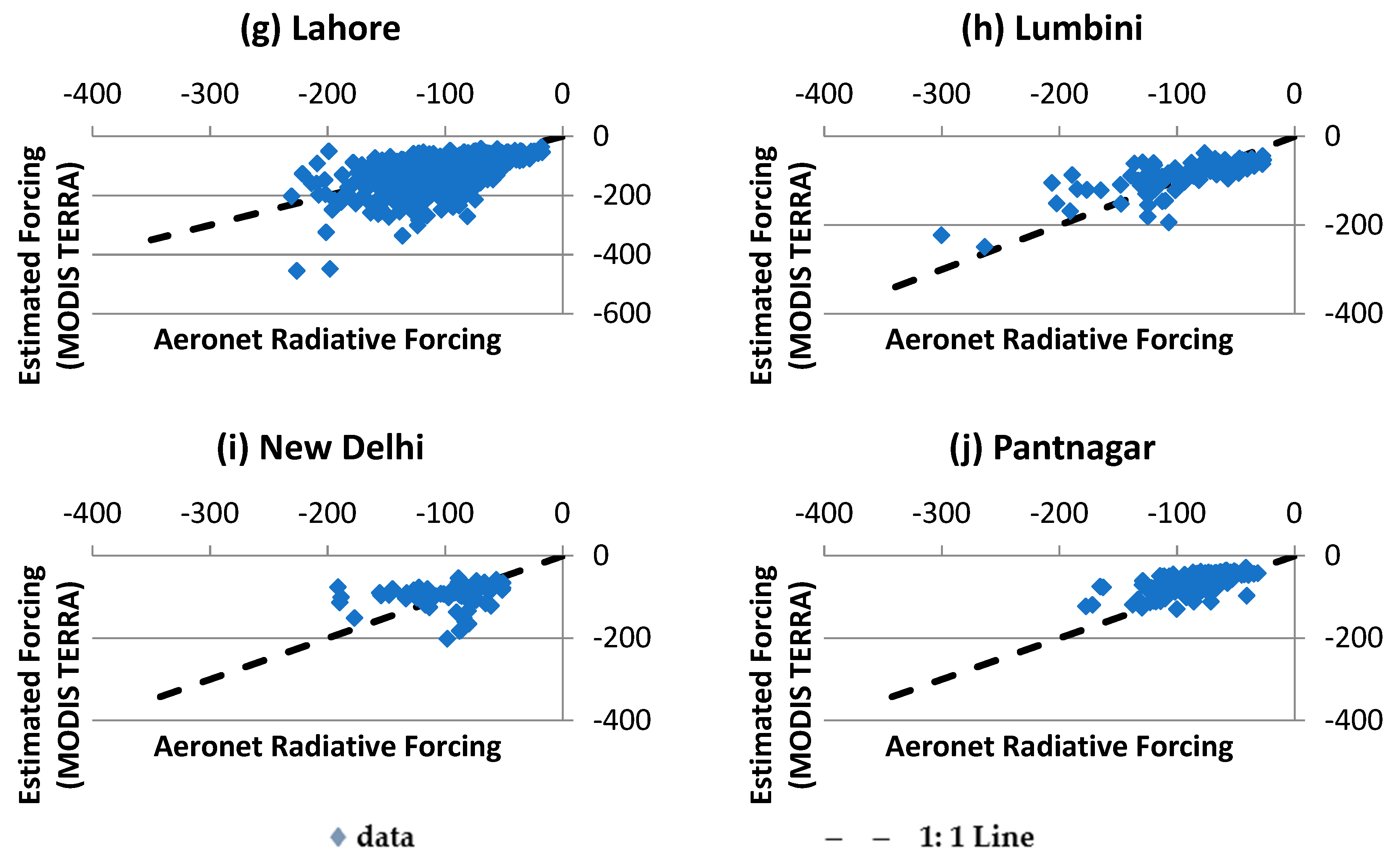
In order to use the year-round ADRF model beyond the AERONET stations, AOD and atmospheric water vapour products from MODIS Aqua and Terra (daily mean AOD at 550 nm and daily mean precipitable water vapour) were compared against AERONET AOD and atmospheric water vapour. Since the RMSE of MODIS Aqua derived daily mean AOD and precipitable water vapour in IGP stations is 0.210 and 0.638 cm with correlation coefficients 0.778 and 0.887, MODIS Aqua product is found to be similar to the AERONET product. Similarly, MODIS Terra product is also found to be similar to the AERONET products because RMSE of MODIS Terra retrieved daily mean AOD and precipitable water vapour is 0.230 and 0.646 cm, respectively, with Pearson correlation coefficients of 0.781 and 0.880, respectively.
By using the MODIS Aqua and MODIS Terra products, the year round ADRF is evaluated in the IGP stations and found that the model performed well with both MODIS products with RMSE 30.700 Wm−2 and 33.080 Wm−2 respectively with Pearson correlation coefficient 0.660 and 0.654 respectively. The ADRF model performed slightly better with MODIS Aqua products than MODIS Terra products. The ADRF model was also compared against the published SBDART results at Karachi and Lahore. The results indicate the ADRF model is comparable with the complex SBDART results. Even though SBDART is found to be better than the year round ADRF model, with respect to RMSE (7.16 Wm−2 against 11.52 Wm−2 at Karachi and 8.86 Wm−2 against 15.67 Wm−2 at Lahore) and correlation coefficients (0.92 against 0.82 at Karachi and 0.98 against 0.71 at Lahore), the developed year round model is much simpler and it requires less input parameters (two compared to more than 60 in SBDART) to estimate radiative forcing at the surface in the IGP.


