Article

Monitoring Seasonal Pasture Quality Degradation in the Mediterranean Montado Ecosystem: Proximal versus Remote Sensing

by
João Serrano
1,*,
Shakib Shahidian
1 and
José Marques da Silva
1,2
1
Instituto de Ciências Agrárias e Ambientais Mediterrânicas, Departamento de Engenharia Rural, Universidade de Évora, P.O. Box 94, 7002-554 Évora, Portugal
2
Agroinsider Lda. (Spin-off of Universidade de Évora), Parque Industrial e Tecnológico de Évora, R. Circular Norte, NERE, Sala 18, 7005-841 Évora, Portugal
*
Author to whom correspondence should be addressed.
Water 2018, 10(10), 1422; https://doi.org/10.3390/w10101422
Submission received: 3 September 2018 / Revised: 7 October 2018 / Accepted: 8 October 2018 / Published: 11 October 2018
(This article belongs to the Special Issue Water Management Using Drones and Satellites in Agriculture)

Abstract

:
Montado is an agro-forestry system occupying a large surface in countries of the Mediterranean region. In this system, the natural dryland pasture is the principal source for animal feed in extensive grazing. The climatic seasonality associated with the inter-annual irregularity of precipitation greatly influences the development of pasture and its vegetative cycle. The end of spring is a critical period in terms of animal feed due to the notable reduction in the nutritive value of the plants. The objective of this work was to evaluate, through the correlation between pasture quality indexes (Pasture Quality Degradation Index, PQDI and Normalized Difference Vegetation Index, NDVI), two technological approaches for monitoring the evolution of the quality of a biodiverse pasture in the period of greatest vegetative development (between February and June). The technological approaches consisted of (i) proximal sensing (PS), with the use of an active optical sensor; and (ii) remote sensing (RS), using images captured by a Sentinel-2 satellite. The results of this study show strong and significant correlations between PQDI and NDVI (obtained by PS or RS). These two techniques (PS or RS) can, therefore, be used in a complementary way to identify and anticipate the food supplementation needs for animals and support farmers in decision making.

Graphical Abstract

1. Introduction

Montado is the most widespread agro-forestry system in Europe, covering 3.5–4.0 Mha in Portugal and Spain (where it is named “Dehesa”) and is commonly found in other Mediterranean regions such as Algeria, Italy, Greece, and Morocco [1]. It represents 33% of the total Portuguese forest area [2] and is usually associated with poor soils. Montado consists of natural or improved (by soil amendment or fertilization) dryland pastures, mainly grazed by sheep, cattle, and pigs, under a sparse cover of cork oak (Quercus suber L.) or of holm oak (Quercus ilex ssp. rotundifolia Lam.). These low maintenance pastures fulfill an important function in rangeland ecology and are fundamental contributors to the productivity and biodiversity of these ecosystems, while sustaining livestock in soils that otherwise would have been considered unproductive [3,4]. Given the fragility of these soils, continued efforts are needed to improve their quality and thus achieve sustained pasture production. At the same time, improvement of pasture quality is an additional management concern because it is fundamental for profitable animal production [5]. Given the seasonal variability in rainfall and temperatures in the Mediterranean climate, pastures associated with montado are characterized by significant seasonal fluctuations in plant species composition and productivity [6]. Dry summers and irregular winter rainfall affect the productivity and duration of the vegetative cycle of dryland pastures [7]. Therefore, vegetation resilience to water stress is an essential factor for the development of pasture in these ecosystems [8].
The annual vegetative cycle begins in autumn, with the appearance of the first rains, and then goes through a dormancy period in winter, due to the low temperatures. In the spring, the simultaneous combination of temperature and precipitation creates conditions for a period of great vegetative vigor. From autumn to spring, pasture is the main source of animal feed in extensive grazing systems; however, starting in late spring or early summer, low precipitation and high temperatures accelerate the final stages in the pasture vegetative cycle, clearly decreasing its nutritional value. In this critical period, farmers need essential data on the spatial and temporal variability of pasture biomass availability in order to safeguard a minimum supply of high quality feed throughout the year [5] and evaluate possible feeding supplementation strategies for the animals, to cover at least their maintenance needs. This information can assist farmers in site-specific soil, pasture, and animal management in agro-silvo-pastoral systems [9]. Viable animal production under these conditions depends heavily on well-informed pasture management and feed planning [3].
Pasture quality can be quantified by certain parameters, such as neutral detergent fiber (NDF) and crude protein (CP) content [10]. It is known that high CP content and low NDF content indicate higher quality pastures [11], which is usually the case when the plants are young. As the pasture develops during the spring, the CP content tends to decrease while the NDF content tends to increase. Serrano et al. [12,13] presented an index designated the pasture quality degradation index, (PQDI, Equation (1)), which uses the NDF/CP ratio to quantify the progressive degradation of pasture quality throughout the growth cycle.
PQDI = NDF CP
The conventional method for obtaining these indicators of pasture quality (CP and NDF) is based on in-situ sampling and chemical analysis. However, this conventional methodology involves intensive field work and lengthy laboratory analysis, which are relatively expensive and sometimes belated, making them unpractical for day-to-day farm management [5,6,10,14].
Remote sensing is becoming an increasingly appealing technology [15], using the relationship between satellite-derived indices and certain crop characteristics [6]. Nonetheless, the application of RS technology in precision grassland management is still relatively limited due to the variability in pastures species [16]. Over the past few years, important developments have been achieved in sensor technology and analytical algorithms, enabling RS to supply comprehensive data for pastures management [5]. These emerging technologies that facilitate the mapping and analysis of pasture variability [
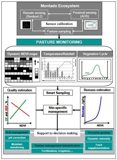
17] are more and more crucial for sustainable animal production. Evaluation of variability is both the first important step and a required condition in the implementation of “Precision Agriculture” (PA) technologies. Current developments in PA, RS, and PS and geospatial analyses associated with GPS provide expedite and non-destructive mapping techniques for portraying the spatial and temporal variation of pasture properties with increasing spatial resolution [18].
The normalized difference vegetation index (NDVI, Equation (2)) is the most frequently used crop index for the definition of management zones [6,14]. It can be obtained using a variety of RS mapping platforms, as well as through PS sensors. This index is based on the measurement of radiation reflected by the plant canopy at two wavelengths: red (RED) and near infrared (NIR).
NDVI = NIR RED NIR + RED
Use of satellite data for RS purposes is very appealing due to the low cost of the images, their geographic scale, and their availability [19]. The resolution of satellite images has improved significantly over the past years, and “Landsat 8”, “Sentinel-1”, or “Sentinel-2” satellites can provide images with a 10 to 30 m resolution [20,21]. Sentinel-1 and Sentinel-2 satellites open new horizons in monitoring pasture growth due to their five-day repeat cycle. According to Lumbierres et al. [6], RS techniques may represent a key tool for the long-term monitoring and management of seasonal ecosystems, as well as for the reconstruction of historical trends, using satellite image time series. However, satellite images obtained on cloudy days can contain patches of highly unreliable values, rendering them mostly unusable [3]. The major disadvantage of optical satellite imagery is thus the requirement of a clear, cloud-free view of the object of interest, which is especially challenging in temperate and rainy regions [22]. Remote sensing images used to study pastures in the montado ecosystem have the added limitation of not accessing the pasture under the tree canopies. This limitation of RS images reinforces the usefulness of PS in montado ecosystems and in any ecosystem where there is an interest in monitoring the understory vegetation [14,23].
The recent evolution of sensor technologies, especially of PS such as “OptRx”, and tools for data analysis and interpretation, provide farmers with easy access to high resolution imagery, allowing the fine scale monitoring of the variability of pastures in montado ecosystems [15]. Complementing this data with RS imagery provides full information on the parameters to support management decisions [18] both under and outside the tree canopy [15].
The objective of this work was to evaluate, through the correlation between pasture quality indexes (PQDI and NDVI), two technological approaches for monitoring the evolution of the quality of a biodiverse pasture in the period of greatest vegetative development (between February and June). The technological approaches consisted of (i) PS, with the use of an active optical sensor; and (ii) RS, using images captured by a Sentinel-2 satellite.

2. Materials and Methods

2.1. Study Area

The area of the study, a paddock, with a size of 2.3 ha (Figure 1), is located in the South of Portugal (38°32.2′ N; 8°01.1′ W). A field of Quercus ilex ssp. rotundifolia Lam., with a tree density of approximately 10 trees ha−1, was maintained for more than two decades with bio-diverse permanent pastures (grasses, legumes, and others) and used for sheep production. The most frequent botanical species present in this ecosystem, in spring 2016, were Chamaemelum mixtum (family Asteraceae), Erodium moschatum (family Geraniaceae), Leontodon taraxacoides (family Asteraceae), Trifolium resupinatum (family Fabaceae), and Plantago coronopus (family Plantaginaceae). Taken together, these represented more than 60% of total cover outside the tree canopy [24]. The main soil is a Cambisol with a granite origin [25]. Cambisols are characterized by slight or moderate weathering of parent material and by the absence of appreciable quantities of illuviated clay, organic matter, aluminium, and/or iron compounds in the top soil.
The Mediterranean climate which characterizes this region, a transition between temperate and dry subtropical climates, normally presents dry summers, where rain is practically absent, and mild or moderately cold winters, with a rather variable rainfall regime. Temperatures are between 8 °C and 26 °C (monthly average), and the minimum temperatures are close to 0 °C in the winter time. Annual rainfall varies between 400 and 600 mm and normally occurs between October and March.
Figure 2 shows the thermo-pluviometric diagram of the Mitra meteorological station between September 2016 and June 2018, which directly affects the vegetative cycle of the dryland pastures in Alentejo. The irregularity of inter-annual distribution of the monthly rainfall is clearly evident. The accumulated rainfall between February and June was 249 mm in 2016, around half of that value in 2017 (125 mm), and practically double in 2018 (457 mm). The rainfall concentration in spring (April and May) is important for the maintenance of pasture growth and the lengthening of the pasture vegetative cycle. In June, the absence of rain and higher temperatures naturally reduces the productivity and the quality of the pasture.

2.2. Pasture Monitoring

Pasture growth was determined in 12 sampling areas without trees using Sentinel 10 m × 10 m pixel (Figure 1) imagery, at each monitoring date of 2017 (coinciding with the dates of the satellite imagery without cloud cover): at the end of winter (14 February and 16 March), and then each month during spring (15 April, 25 May, and 14 June). Multispectral measurements with a proximal optical sensor were carried out immediately before pasture sampling.

2.2.1. Vegetation Multispectral Measurements by Proximal Sensing

The multispectral bands were obtained with a commercial “OptRxTM” active optical sensor, manufactured by Ag Leader (Ames, IA, USA). This sensor was associated with a Trimble GNSS GeoExplorer 6000 series model 88951 (Trimble Navigation Limited, Raunheim, Germany), with sub-meter precision. The sensor was transported by a mobile platform at an average speed of 5 km h−1, and was positioned approximately 0.50 m above the pasture, with a field of view of about 0.3 m2. The sensor emits radiation in a modulated frequency and receives back the radiance in the different channels. With this particular sensor, the following radiance bands were obtained: (i) RED (670 nm); (ii) RED EDGE (728 nm); and (iii) NIR (775 nm). With the RED and the NIR bands, the NDVI was calculated using Equation (1).
In each of the 12 geo-referenced pixels, measurements were performed for a 2 min period. On average, in each sampling date, 120 measurements were taken (one per second) in three representative locations within each pixel area (10 m × 10 m) and from these, the mean, the standard deviation (SD), the coefficient of variation (CV), and the NDVI range were calculated.

2.2.2. Vegetation Multispectral Measurements by Remote Sensing

Sentinel-2 is an earth observation mission, managed by the European Satellite Agency. The twin optical satellites produce a frequency of revisit of five days at the Equator [26].
For this particular work, Sentinel-2 band 8 (NIR; 10 m spatial resolution; 842 nm) and band 4 (RED; 10 m spatial resolution; 665 nm), atmospherically corrected imagery [26], were downloaded from Copernicus data hub and used to calculate NDVI (Equation (1)). Satellite vegetation index (NDVISAT) data was extracted in the 12 geo-referenced pixels where the measurements with the active optical sensor were performed between February and June 2017. In order to conduct the reconstruction of historical NDVI trends, following the same procedure as formerly described, time series NDVI records were retrieved for the spring of 2016, 2017, and 2018.

2.2.3. Pasture Sample Collection and Analysis

After proximal sensing data acquisition, a composite pasture sample was collected, taking into consideration a 0.25 m2 area (0.50 m × 0.50 m) at three representative locations within each of the 12 pixels sampled. Inside each sampling point, pasture was: (i) harvested 1 to 2 cm above ground level; (ii) freshly weighted; (iii) dehydrated (72 h at 65 °C); and (iv) dry weighted again, in order to establish pasture productivity in terms of biomass (kg·ha−1). The dried samples were analysed (in % of dry matter) [27] in order to determine CP and NDF content.

2.3. Statistical Analysis

The range, mean, SD, and CV were obtained for pasture (Biomass, CP, NDF, PQDI) and sensor parameters (NDVI, obtained from PS and satellite) data.
In order to perform non-linear regression analysis (p < 0.05) between pasture and sensor variables, ‘MSTAT’ software (MSTAT-C, East Lansing, MI, USA) was used.

3. Results and Discussion

3.1. Evolution of Pasture Parameter Patterns throughout the Vegetative Cycle

Table 1 summarizes the results of descriptive statistics (mean, SD, CV, and interval of variation) of pasture parameters, measured at the twelve sampling points of the studied field, for each sampling date and for the total period considered (between February and June 2017).
The characteristic seasonality of the Mediterranean climate is evident, showing the typical evolution of parameters over the months, which will be discussed in detail in the following figures. Another highlight is related to the great spatial variability, especially of biomass (CV above 30% at all evaluation periods), an aspect already described in other works related to the montado ecosystem [28]. This spatial variability is the starting point for a PA strategy [13].
Another salient aspect is related to the pasture quality parameters: CVs above 20% were observed in February (24.6, 25.2, and 51.8, respectively, for CP, NDF, and PQDI), with a tendency for CV to decrease during the vegetative cycle, reaching minimum values in June (14.5, 3.4, and 17.1, respectively, for CP, NDF, and PQDI). This behavior reflects, in February, the variability resulting from the heterogeneous development of the different plant species that are part of the biodiverse pasture. On the other hand, at the end of the vegetative cycle of dryland annual pastures, the nutritive value of the plants is generally low, as a result of lack of soil moisture, which can be more or less homogeneous.
Regarding NDVI, obtained by PS or RS, the CVs were lower than 15% during the months of greater vegetative growth (February, March and April), but increased to values of around 15–25% in the last months of the vegetative cycle (May and June), when the average values of NDVI decreased below 0.350.
Figure 3 and Figure 4 illustrate the evolution of mean values of pasture parameters (Biomass, CP, NDF, PQDI, and NDVI) over the period considered (February–June 2017).
Figure 3 shows the discrepancy between the peak biomass production (in this case occurring in April 2017) and the NDVI peak (which occurred in March 2017). This behaviour reflects the principle on which NDVI measurement is based: the optical sensor detects high levels of chlorophyll (photosynthetically active vegetation), which is abundant in green vegetation [29]. As pasture develops, the fiber content increases, resulting in a proportional decrease in the chlorophyll content and leading to a reduction in the NDVI, while the total pasture biomass continues to increase until full maturation of the pasture [24].
The NDVI obtained between April and June from satellite images shows a similar trend to that determined from PS, only with a smaller amplitude of variation, which can be justified by the sampling area: while the measurements of the PS are restricted to small sampling areas (3 locations × 0.50 m × 0.50 m), those obtained from satellite images involve a much larger area (10 m × 10 m pixel).
The typical pattern of quality decrease over the growth cycle of pasture under the montado system is presented in Figure 4: as the end of spring approaches, a significant reduction in CP and a sustained increase in NDF can be observed [12,30]. A critical moment for pasture management and animal husbandry is when CP content decreases to below the animal maintenance requirement, which is 9.4% for sheep [31]. In this study, feed supplementation was required from mid-April onwards, which occurred earlier than usual given that 2017 was a relatively dry year (Figure 2), reinforcing the interest in tools that can quickly monitor the pasture and identify and anticipate these critical moments in terms of management of animal feed supplementation.
The ratio between NDF and CP was presented in [12,13] as an index (PQDI) that reflects the degradation of pasture quality: higher values of this index correspond to a higher fiber content and lower CP content in the pasture. Figure 4 shows the continuous increase of this index between March and June 2017, which is different from the pattern observed for NDVI. The arrows in this figure indicate the correspondence between animal maintenance requirements in terms of CP, PQDI (7 in this case), and NDVI (0.6 in this case, independently of the form of measurement, PS or RS). The evaluation of the behaviour of NDVI (and, consequently, of PQDI and CP) may be important in order to understand the critical moment at which animal feed supplementation should be introduced, which will continue until the first rains at the beginning of autumn [12,13].
Published results [13] show strong correlations between NDVIPS and pasture quality indicators (CP, NDF, PQDI) in tests conducted in the same field during spring 2016. Although all-terrain vehicle transported PS associated with geo-referencing systems represents an expedited way of monitoring pasture, it requires the participation of technicians in the field, entailing costs and time, which need to be reduced through further research and technical developments.

3.2. NDVI Time Series Obtained from Satellite during Three Consecutive Springs (2016–2018)

Remote sensing techniques based on satellite images using time series are especially important for the identification of stable recurring crop patterns [22], even though the practical application is constrained by poor quality images on cloudy days [23], which can occur frequently during the spring.
Figure 5 shows the reconstruction of historical NDVI trends, time series records of NDVISAT, retrieved between February and June of 2016, 2017, and 2018. Values are the mean of the 12 pixels considered in this study. Red circles identify, in each year, the images affected by cloud cover. In 2018, the shorter interval between successive satellite revisits (five-day temporal resolution) allowed a higher frequency of image capture than in 2016 and 2017 (usually 10 days), which is an important advantage when the cloud interference partially or totally affects the images [3].
Figure 6 shows the same trends, but without the records affected by the existence of clouds. There is a trend, common to the three years, consisting of a rise in NDVI values at the beginning of spring, reaching a maximum value between March and April, followed by a clear fall. This pattern reflects the effect of the distribution of precipitation (Figure 7): while in 2017 (which may be considered a relatively dry year, with only 120 mm of accumulated rainfall between February and April and only 5 mm between May and June), the NDVI break occurs early in April (shortly after the day of the year (DOY), 95); and in 2018 (which can be considered a relatively humid year, with 382 mm of accumulated rainfall between February and April and 74 mm between May and June), the break only occurs at the end of May (after DOY 135). However, in 2018, the tendency for an NDVI break which should have occurred around DOY 95 (same as in a dry year, 2017), was inverted from DOY 110 onwards (mid-April) due to the greater availability of water to plants, associated with the increase in the air temperature. This greater availability of water in the soil was due to the significant amount of rainfall accumulated in April 2018 (104 mm), which inverted the tendency observed in the months of March (72 mm) and May (49 mm) (Figure 7). In 2016 (which may be considered an intermediate year, with 244 mm of accumulated rainfall between February and June and only 5 mm between May and June), the NDVI break occurs in early May (after DOY 121). This pattern confirms that pasture biomass production is strongly dependent on precipitation in dryland ecosystems [28]. Gao et al. [32] and Jin et al. [33] also state that climatic factors such as precipitation and temperature are responsible for inter-annual fluctuations of biomass. In Figure 6, arrows indicate the moment in which, in each year, the abrupt fall of the NDVI below 0.6 occurs: the difference of about one month between the dry year (2017, fall in mid-April) and the other years (2016 and 2018, mid and late May) highlights the interest and importance of this approach in the dynamic management of animal grazing. Since this indicator (NDVI = 0.6) identifies the moment when pasture CP content falls below the animal maintenance requirements, it allows adjusting the timing of supplementary feeding over a period of one month, with important cost saving implications.
Figure 8 shows the trend line of NDVISAT observed between February and June over the three years (2016–2018). The use of NDVI time series was proposed in study [6] to estimate the parameters describing vegetation phenology, a technique which is very relevant in multiple domains, such as productivity and the carbon cycle, climate change and its impacts on ecosystems, and crop and pasture monitoring.

3.3. Correlation between Pasture Parameters and NDVI Obtained from Proximal and Remote Sensing

Figure 9 shows the correlation between NDVI values obtained by PS (NDVIPS) and those obtained by the satellite (NDVISAT), in the set of monthly sampling dates (between February and June 2017). The resulting significant and strong coefficient of determination (R2 = 0.8138, p < 0.01) shows the close relationship between these indexes. The smaller amplitude of variation of NDVISAT is also evident, as noted above. This “dilution effect” (NDVISAT > NDVIPS for values less than 0.5 and NDVISAT < NDVIPS for NDVI values greater than 0.5) would be expected as a result of the different scales of pasture sampling areas considered: while the sampling carried out with PS only covered three small areas (0.25 m2 each), RS sampling covered the area of a satellite pixel (100 m2) and can include the spatial details of the aboveground biomass across the entire area. “Scale effect” between RS and PS data was also reported by Zhao et al. [34].
Figure 10, Figure 11, Figure 12 and Figure 13 show the correlations between NDVI (estimated from both PS and satellite images) and biomass, CP, NDF, and PQDI. All these correlations are significant, although stronger in the case of NDVIPS than in the case of NDVISAT, which immediately reflects the sampling process: while NDVIPS was obtained from PS measurements carried out directly on the pasture that was to be cut and subjected to analytical determinations (biomass, CP, NDF, and PQDI), NDVISAT involved a considerably larger sampling area, a factor particularly important due to the strong spatial and temporal heterogeneity characteristics of biodiverse pastures [10]. According to these authors, this factor contributes to non-linear relationships between NDVI and pasture parameters. Other key problem related to NDVI images may be due to noise or errors, which can contribute to non-linear relationships between NDVI and pasture parameters [5,6]. Although this article focuses on the monitoring of pasture quality indicators, the correlation of NDVI (obtained from PS and satellite) with pasture productivity is presented in Figure 10.
Several studies, based on advances in RS technology, have used higher-resolution images to estimate grassland productivity and biomass [33,34]. The correlations obtained in this study are significant, but the coefficients of determination are relatively low (R2 = 0.4686, p < 0.05 for NDVIPS and R2 = 0.3801, p < 0.05 for NDVISAT) and are in line with other studies. Lumbierres et al. [6] obtained coefficients of determination between 0.39 and 0.65 when estimating pasture biomass based on NDVI. According to Pullanagari et al. [35], pastures have high diversity due to spatial and temporal heterogeneity resulting from a number of confounding factors, including diverse species, morphology and interactions between the grazing animals, the natural environmental conditions, and management practices. Jin et al. [33] and Zhao et al. [34] state that the high spatial heterogeneity of grassland species and, specifically in low-coverage grasslands, the significant influence of the soil background, can lead to high errors of estimation. In addition, in high-coverage grasslands, the NDVI shows decreased sensitivity, resulting in a decline in the accuracy of biomass estimates [34]. The saturation point is dependent on the pasture species, chlorophyll content, and the morphology of the plants [36]. In this grassland ecosystem, NDVI saturated at biomass values of approximately 15,000 kg·ha−1 (Figure 10). Schmidt et al. [4], Lumbierres et al. [6], Trotter et al. [36], Schaefer and Lamb [37], and Serrano et al. [38] also referenced the saturation of NDVI for pasture biomass. To overcome this problem, Schaefer and Lamb [37] suggested the use of an index that associates spectral reflectance measurements (NDVI) with a vegetation property such as plant height, thus mitigating the saturation issue and increasing the biomass range that can be estimated from NDVI. On the other hand, Serrano et al. [38] developed calibration equations for a capacitance probe (“Grassmaster II”; Novel Ways Electronic, Hamilton, New Zealand) and demonstrated the ability of this device to estimate the productivity of typical Mediterranean pastures (grasses, vegetables, mixture and volunteer annual species) with a very acceptable degree of precision at different phenological stages and pasture moisture contents, suggesting that the quantitative information (pasture productivity) obtained by the capacitance probe can complement qualitative information obtained by optical PS or RS (pasture quality).
Correlations of NDVI obtained from PS or RS with pasture quality parameters (CP and NDF, Figure 11 and Figure 12, respectively) were relatively strong and significant: with CP, R2 = 0.7537, p < 0.01 for NDVIPS and R2 = 0.503, p < 0.05 for NDVISAT; with NDF, R2 = 0.8335, p < 0.01 for NDVIPS and R2 = 0.7633, p < 0.01 for NDVISAT. These values are within the order of magnitude of those obtained by Serrano et al. [13] with PS (0.69 and 0.78, respectively, for CP and NDF) and of those obtained by Zhao et al. [19] (0.61 and 0.58, respectively, for CP and NDF) with reflectance data obtained by RS. Pullanagari et al. [35] and Albayrak [39] also found satisfactory relationships between spectral measurements and pasture quality parameters, which can be attributed to the absorbance of visible radiance by the existing chlorophyll in green vegetation.
Correlations of NDVI obtained from PS or RS with the pasture quality degradation index (PQDI, Figure 13) were relatively strong and significant: R2 = 0.8346, p < 0.01 for NDVIPS and R2 = 0.6451, p < 0.01 for NDVISAT. The synoptic and sequential coverage provided by RS imagery, supplemented by ecological indicators and biophysical pasture properties, provides the necessary tools for integrated data analysis and the development of predictive models for decision making at the farmer level. The seasonality of pasture production and the typical inter-annual variability of the Mediterranean climate accentuate the importance of developing monitoring and management systems and even alarm systems for farmers based on the measurement of montado NDVI from satellite images (RS). Proximal sensing can be used in a complementary way, helping to overcome the main difficulties associated with satellite imagery, in particular those related to resolution, access under the tree canopy and, especially, with cloud cover.
To summarize, in a context where the inter-annual variation in precipitation is a key climatic driver for biomass production and quality, a site-specific approach is needed for implementing smart pasture/animal management systems [6]. Mapping patterns of pasture yield and quality is an important first step to support management strategies to prevent land degradation and biodiversity loss. In this regard, the study of pasture management zones could be improved by correlating the changes in vegetation biomass (quantity and quality) with rainfall distribution trends in order to support decision-making at the levels of soil management, pasture intensification, or precision grazing. Therefore, the grassland response to climate change is complex, and deserves more detailed and deeper inquiry in future research [34].

4. Conclusions

In a montado ecosystem, dryland pastures are the principal source of food for animals under extensive grazing. Under these conditions, the climatic seasonality associated with the inter-annual irregularity of precipitation, especially during spring, greatly determines the development of the pasture vegetative cycle and the evolution of its nutritive value. At this stage, a critical period begins for the farmer, who needs access to information on the evolution of PQDI in order to anticipate the supplementation of the animals to ensure their maintenance needs. The results of this exploratory and pioneer study in pastures in Portugal, show strong and significant correlations between PQDI and NDVI, obtained by proximal sensing (PS) or remote sensing (RS). The vegetation index (NDVI) below 0.6 (and PQDI above 7) indicated, in 2017, the need for animal supplementation starting in mid-April. However, the historical recovery of vegetation indexes (VI) from time series obtained by RS for 2016 and 2018 showed inter-annual variability of about one month for this threshold to be achieved, which highlights the interest and importance of this approach in the dynamic management of animal grazing. Although RS presents several operational advantages over PS, frequent spring cloudiness may be an obstacle to the regular determination of VI, which can lead to longer periods of time without information. This obstacle, together with the difficulty in evaluating VI under the tree canopy, justifies the interest in using these two techniques in a complementary way as information and alarm systems to support soil, pasture, and grazing management. Therefore, it is important to disseminate the potential of these techniques and technologies and extend these studies to other type of pastures/grasslands and production systems.

Author Contributions

J.S.: Conceptualization, literature review, planning and execution of experimental work, processing of data, discussion of results, and writing original draft of this manuscript. S.S.: Conceptualization, planning and execution of experimental work, discussion of results, and final revision/edition of the English. J.M.d.S.: Conceptualization, processing of data, discussion of results, and help producing the final version of the paper.

Funding

This work was funded by National Funds through FCT (Foundation for Science and Technology) under the Project UID/AGR/00115/2013, and by the project INNOACE—Innovación abierta e inteligente en la EUROACE (Tarea 2.1.3).

Acknowledgments

The authors would like to express their sincere appreciation to Emanuel Carreira and Graça Machado of Animal Production Department of University of Évora for their support in, respectively, collection and analysis of pasture data. They would also like to express their sincere appreciation to Luís Paixão for your support in data collection of satellite images.

Conflicts of Interest

The authors declare no conflict of interest.

References

  1. Seddaiu, G.; Porcua, G.; Ledda, L.; Roggero, P.; Agnelli, A.; Cortic, G. Soil organic matter content and composition as influenced by soil management in a semi-arid Mediterranean agro-silvo-pastoral system. Agric. Ecosyst. Environ. 2013, 167, 1–11. [Google Scholar] [CrossRef]
  2. David, T.; Pinto, C.; Nadezhdina, N.; Kurz-Besson, C.; Henriques, M.; Quilhó, T.; Cermak, J.; Chaves, M.; Pereira, J.; David, J. Root functioning, tree water use and hydraulic redistribution in Quercus suber trees: A modeling approach based on root sap flow. For. Ecol. Manag. 2013, 307, 136–146. [Google Scholar] [CrossRef]
  3. Wang, X.; Linlin, G.; Li, X. Pasture monitoring using SAR with COSMO-SkyMed, ENVISAT ASAR, and ALOS PALSAR in Otway, Australia. Remote Sens. 2013, 5, 3611–3636. [Google Scholar] [CrossRef]
  4. Schmidt, M.; Carter, J.; Stone, G.; O’Reagain, P. Integration of optical and X-band radar data for pasture biomass estimation in an open savannah woodland. Remote Sens. 2016, 8, 989. [Google Scholar] [CrossRef]
  5. Pullanagari, R.R.; Kereszturi, G.; Yule, I. Integrating airborne hyperspectral, topographic, and soil data for estimating pasture quality using recursive feature elimination with random forest regression. Remote Sens. 2018, 10, 1117. [Google Scholar] [CrossRef]
  6. Lumbierres, M.; Méndez, P.F.; Bustamante, J.; Soriguer, R.; Santamaria, L. Modeling biomass production in seasonal wetlands using Modis NDVI land surface phenology. Remote Sens. 2017, 9, 392. [Google Scholar] [CrossRef]
  7. Murray, R.I.; Yule, I.J.; Gillingham, A.G. Developing variable rate application technology: Modelling annual pasture production on hill country. N. Z. J. Agric. Res. 2007, 50, 41–52. [Google Scholar] [CrossRef]
  8. Paço, T.; David, T.; Henriques, M.; Pereira, J.; Valente, F.; Banza, J.; Pereira, F.; Pinto, C.; David, J. Evapotranspiration from a Mediterranean evergreen oak savannah: The role of trees and pasture. J. Hydrol. 2009, 369, 98–106. [Google Scholar] [CrossRef]
  9. Safari, H.; Fricke, T.; Reddersen, B.; Mockel, T.; Wachendorf, M. Comparing mobile and static assessment of biomass in heterogeneous grassland with a multi-sensor system. J. Sens. Sens. Syst. 2016, 5, 301–312. [Google Scholar] [CrossRef] [Green Version]
  10. Lugassi, R.; Chudnovsky, A.; Zaady, E.; Dvash, L.; Goldshleger, N. Spectral slope as an indicator of pasture quality. Remote Sens. 2015, 7, 256–274. [Google Scholar] [CrossRef]
  11. Ren, Q.; Jin, X.; Zhang, Z.; Yang, H.; Li, S. Effects of dietary neutral detergent fibre to protein ratio on duodenal microbial nitrogen flow and nitrogen losses in lactating cows fed high-concentrate total mixed rations with different forage combinations. J. Agric. Sci. 2015, 153, 753–764. [Google Scholar] [CrossRef]
  12. Serrano, J.; Sales-Baptista, E.; Shahidian, S.; Marques da Silva, J.; Ferraz de Oliveira, I.; Lopes de Castro, J.; Pereira, A.; Cancela d’Abreu, M.; Carvalho, M. Proximal sensors for monitoring seasonal changes of feeding sites selected by grazing ewes. Agrofor. Syst. 2018. [Google Scholar] [CrossRef]
  13. Serrano, J.; Shahidian, S.; Marques da Silva, J.; Carvalho, M. A holistic approach to the evaluation of the montado ecosystem using proximal sensors. Sensors 2018, 18, 570. [Google Scholar] [CrossRef] [PubMed]
  14. Louhaichi, M.; Hassan, S.; Clifton, K.; Johnson, D.E. A reliable and non-destructive method for estimating forage shrub cover and biomass in arid environments using digital vegetation charting technique. Agrofor. Syst. 2018, 92, 1341–1352. [Google Scholar] [CrossRef]
  15. Nawar, S.; Corstanje, R.; Halcro, G.; Mulla, D.; Mouazen, A.M. Delineation of soil management zones for variable-rate fertilization: A review. Adv. Agron. 2017, 143, 175–245. [Google Scholar]
  16. Garrido, P.; Elbakidze, M.; Angelstam, P.; Plieninger, T.; Pulido, F.; Moreno, G. Stakeholder perspectives of wood-pasture ecosystem services: A case study from Iberian dehesas. Land Use Policy 2017, 60, 324–333. [Google Scholar] [CrossRef]
  17. Zhang, Y.; Xiao, Y.; Zhuang, Z.; Zhou, L.; Liu, F.; He, Y. Development of a near ground remote sensing system. Sensors 2016, 16, 648. [Google Scholar] [CrossRef] [PubMed]
  18. Moeckel, T.; Safari, H.; Reddersen, B.; Fricke, T.; Wachendorf, M. Fusion of ultrasonic and spectral sensor data for improving the estimation of biomass in grassland with heterogeneous sward structure. Remote Sens. 2017, 9, 98. [Google Scholar] [CrossRef]
  19. Zhao, D.; Starks, P.; Brown, M.; Phillips, W.; Coleman, S. Assessment of forage biomass and quality parameters of bermudagrass using proximal sensing of pasture canopy reflectance. Grassl. Sci. 2007, 53, 39–49. [Google Scholar] [CrossRef]
  20. Modica, G.; Solano, F.; Merlino, A.; Di Fazio, S.; Barreca, F.; Laudari, L.; Fichera, C.R. Using Landsat 8 imagery in detecting cork oak (Quercus suber L.) woodlands: A case study in Calabria (Italy). J. Agric. Eng. 2016, 47, 205–215. [Google Scholar] [CrossRef]
  21. Edirisinghe, A.; Hill, M.J.; Donald, G.E.; Hyder, M. Quantitative mapping of pasture biomass using satellite imagery. Int. J. Remote Sens. 2011, 32, 2699–2724. [Google Scholar] [CrossRef]
  22. Georgi, C.; Spengler, D.; Itzerott, S.; Kleinschmit, B. Automatic delineation algorithm for site-specific management zones based on satellite remote sensing data. Precis. Agric. 2018, 19, 684–707. [Google Scholar] [CrossRef]
  23. Handcock, R.N.; Gobbett, D.L.; González, L.A.; Bishop-Hurley, G.J.; McGavin, S.L. A pilot project combining multispectral proximal sensors and digital cameras for monitoring tropical pastures. Biogeosciences 2016, 13, 4673–4695. [Google Scholar] [CrossRef]
  24. Serrano, J.; Shahidian, S.; Marques da Silva, J.; Sales-Baptista, E.; Ferraz de Oliveira, I.; Lopes de Castro, J.; Pereira, A.; Cancela de Abreu, M.; Machado, E.; Carvalho, M. Tree influence on soil and pasture: Contribution of proximal sensing to pasture productivity and quality estimation in montado ecosystems. Int. J. Remote Sens. 2018, 39, 4801–4829. [Google Scholar] [CrossRef]
  25. FAO. World Reference Base for Soil Resources; Food and Agriculture Organization of the United Nations, World Soil Resources Reports No. 103; IUSS Working Group WRB: Rome, Italy, 2006. [Google Scholar]
  26. ESA (European Space Agency). S2 MPC: Sen2Cor Configuration and User Manual; Ref. S2-PDGS-MPC-L2A-SUM-V2.5.5; ESA (European Space Agency): Paris, France, 2018. [Google Scholar]
  27. AOAC. AOAC Official Methods of Analysis of AOAC International, 18th ed.; AOAC International: Arlington, VA, USA, 2005. [Google Scholar]
  28. Serrano, J.; Peça, J.; Marques da Silva, J.; Shahidian, S. Spatial and temporal stability of soil phosphate concentration and pasture dry matter yield. Precis. Agric. 2011, 12, 214–232. [Google Scholar] [CrossRef]
  29. Reddy, A.R.; Chaitanya, K.V.; Vivekanandan, M. Drought-induced responses of photosynthesis and antioxidant metabolism in higher plants. J. Plant Physiol. 2004, 161, 1189–1202. [Google Scholar] [CrossRef]
  30. Ferraz de Oliveira, M.; Lamy, E.; Bugalho, M.; Vaz, M.; Pinheiro, C.; Cancela d’Abreu, M.; Capela e Silva, F.; Sales-Baptista, E. Assessing foraging strategies of herbivores in Mediterranean oak woodlands: A review of key issues and selected methodologies. Agrofor. Syst. 2013, 87, 1421–1437. [Google Scholar] [CrossRef] [Green Version]
  31. National Research Council. Nutrient Requirements of Sheep (Vol. 5), Six Revised ed.; National Academy Press: Washington, DC, USA, 1985. [Google Scholar]
  32. Gao, T.; Yang, X.C.; Jin, Y.X.; Ma, H.L.; Li, J.Y.; Yu, H.D.; Yu, Q.Y.; Xiao, Z.; Xu, B. Spatio-temporal variation in vegetation biomass and its relationships with climate factors in the Xilingol grasslands, Northern China. PLoS ONE 2013, 8, e83824. [Google Scholar] [CrossRef] [PubMed]
  33. Jin, Y.; Yang, X.; Qiu, J.; Li, J.; Gao, T.; Wu, Q.; Zhao, F.; Ma, H.; Yu, H.; Xu, B. Remote Sensing-Based Biomass Estimation and Its Spatio-Temporal Variations in Temperate Grassland, Northern China. Remote Sens. 2014, 6, 1496–1513. [Google Scholar] [CrossRef] [Green Version]
  34. Zhao, F.; Xu, B.; Yang, X.; Jin, Y.; Li, J.; Xia, L.; Chen, S.; Ma, H. Remote Sensing Estimates of Grassland Aboveground Biomass Based on MODIS Net Primary Productivity (NPP): A Case Study in the Xilingol Grassland of Northern China. Remote Sens. 2014, 6, 5368–5386. [Google Scholar] [CrossRef] [Green Version]
  35. Pullanagari, R.; Yule, I.; Tuohy, M.; Hedley, M.; Dynes, R.; King, W. Proximal sensing of the seasonal variability of pasture nutritive value using multispectral radiometry. Grass Forage Sci. 2013, 68, 110–119. [Google Scholar] [CrossRef]
  36. Trotter, M.G.; Lamb, D.W.; Donald, G.E.; Schneider, D.A. Evaluating an active optical sensor for quantifying and mapping green herbage mass and growth in a perennial grass pasture. Crop Pasture Sci. 2010, 61, 389–398. [Google Scholar] [CrossRef]
  37. Schaefer, M.T.; Lamb, D.W. A combination of plant NDVI and Lidar measurements improve the estimation of pasture biomass in Tall Fescue (Festuca Arundinacea Var. Fletcher). Remote Sens. 2016, 8, 109. [Google Scholar] [CrossRef]
  38. Serrano, J.; Shahidian, S.; Marques da Silva, J. Calibration of GrassMaster II to estimate green and dry matter yield in Mediterranean pastures: Effect of pasture moisture content. Crop Pasture Sci. 2016, 67, 780–791. [Google Scholar] [CrossRef]
  39. Albayrak, S. Use of reflectance measurements for the detection of N, P, K, ADF and NDF contents in Sainfoin pasture. Sensors 2008, 8, 7275–7286. [Google Scholar] [CrossRef] [PubMed]
Figure 1. Experimental field located at the Mitra farm in the summer of 2016.
Water 10 01422 g001
Figure 2. Thermo-pluviometric diagram of the Mitra meteorological station between September 2015 and June 2018.
Water 10 01422 g002
Figure 3. Evolution, between February and June 2017, of pasture productivity (Biomass) and vegetation index obtained by proximal sensor (NDVIPS) and by satellite (NDVISAT). Data are average values of the twelve sampling points.
Water 10 01422 g003
Figure 4. Evolution, between February and June 2017, of pasture nutritive value parameters (crude protein, CP; neutral detergent fiber, NDF; and pasture quality degradation index, PQDI) and vegetation index (obtained from proximal sensor, NDVIPS; and from satellite, NDVISAT). Data are average values of the twelve sampling points. The arrows indicate the sheep maintenance requirements in terms of CP (9.4%) and their correspondence with PQDI (7 in this case) and with NDVI (0.6 in this case).
Water 10 01422 g004
Figure 5. Reconstruction of historical vegetation index trends using time series records of satellite images (NDVISAT), retrieved between February and June 2016 (a), 2017 (b) and 2018 (c). Data are average values of the twelve sampling points. Red circles identify, in each year, the images affected by cloud cover over the study field. Note: Date format: Day/Month.
Water 10 01422 g005
Figure 6. Reconstruction of historical vegetation index trends using time series records of satellite images (NDVISAT), retrieved between February and June 2016, 2017, and 2018, without the records affected by the existence of clouds. Data are average values of the twelve sampling points. Arrows indicate the moment in which, in each year, the abrupt fall of the NDVI below 0.6 occurs.
Water 10 01422 g006
Figure 7. Accumulate monthly rainfall and vegetation index time series obtained by satellite images (NDVISAT) between February and June 2016 (a), 2017 (b), and 2018 (c).
Water 10 01422 g007
Figure 8. Trend line of vegetation index obtained by satellite (NDVISAT) between February and June over three years (2016–2018). Data are average values of the twelve sampling points. DOY-Day of the year.
Water 10 01422 g008
Figure 9. Correlation between vegetation index values obtained by proximal sensor (NDVIPS) and those obtained by satellite (NDVISAT), in the set of monthly sampling dates (between February and June 2017). The dotted line corresponds to the perfect correlation (R2 = 1).
Water 10 01422 g009
Figure 10. Correlation between vegetation index values (obtained by proximal sensor, NDVIPS; and by satellite, NDVISAT) and pasture biomass, in the set of monthly sampling dates (between February and June 2017).
Water 10 01422 g010
Figure 11. Correlation between vegetation index values (obtained by proximal sensor, NDVIPS; and by satellite, NDVISAT) and pasture crude protein (CP), in the set of monthly sampling dates (between February and June 2017).
Water 10 01422 g011
Figure 12. Correlation between vegetation index values (obtained by proximal sensor, NDVIPS; and by satellite, NDVISAT) and pasture neutral detergent fiber (NDF), in the set of monthly sampling dates (between February and June 2017).
Water 10 01422 g012
Figure 13. Correlation between NDVI values (obtained by proximal sensor, NDVIPS; and by satellite, NDVISAT) and pasture quality degradation index (PQDI), in the set of monthly sampling dates (between February and June 2017).
Water 10 01422 g013
Table 1. Descriptive statistics of pasture parameters, measured at the twelve sampling points of the studied field, for each sampling date and for the total period considered (between February and June 2017).
Pasture ParametersMean ± SDCV (%)Range
Biomass (kg·ha−1)
February6300 ± 380260.4800–11,900
March11,292 ± 604153.53200–25,000
April14,567 ± 844057.97200–36,700
May5767 ± 217837.82900–9800
June1725 ± 76344.21000–3900
February–June7930 ± 666084800–36,700
CP (%)
February14.2 ± 3.524.68.6–18.7
March14.8 ± 3.221.610.2–19.8
April7.4 ± 1.317.85.6–10.3
May7.7 ± 1.2165.5–9.8
June5.4 ± 0.814.54.4–6.9
February–June9.9 ± 4.545.24.4–19.8
NDF (%)
February51.2 ± 12.925.235.0–77.5
March49.6 ± 7.815.736.9–64.6
April60.4 ± 5.18.454.0–70.2
May72.7 ± 3.75.165.6–79.6
June78.1 ± 2.63.474.2–83.9
February–June62.4 ± 13.521.635.0–83.9
PQDI
February4.0 ± 2.151.82.0–9.0
March3.5 ± 1.233.62.3–6.4
April8.5 ± 1.922.95.4–12.5
May9.7 ± 2.020.36.9–14.4
June14.9 ± 2.517.111.1–18.8
February–June8.1 ± 4.656.72.0–18.8
NDVIPS
February0.748 ± 0.10914.50.563–0.860
March0.813 ± 0.0536.50.680–0.890
April0.554 ± 0.06511.70.450–0.650
May0.314 ± 0.07724.50.240–0.450
June0.173 ± 0.03117.90.160–0.190
February–June0.520 ± 0.25749.40.160–0.890
NDVISAT
February0.576 ± 0.05910.20.475–0.649
March0.640 ± 0.0396.10.560–0.692
April0.596 ± 0.0518.50.516–0.686
May0.340 ± 0.05215.40.264–0.444
June0.261 ± 0.04818.30.201–0.345
February–June0.460 ± 0.14331.20.201–0.692
CP-Crude protein; NDF-Neutral detergent fiber; PQDI-Pasture quality degradation index; NDVIPS-Normalized difference vegetation index determined by optical active sensor; NDVISAT-Normalized difference vegetation index determined by satellite; SD-Standard deviation; CV-Coefficient of variation.

