Article

Preliminary Numerical Analysis of the Efficiency of a Central Lake Reservoir in Enhancing the Flood and Drought Resistance of Dongting Lake

1
School of Hydraulic Engineering, Changsha University of Science & Technology, Changsha 410114, Hunan, China
2
Hunan Province Key Laboratory of Water, Sediment Sciences & Flood Hazard Prevention, Changsha 410114, Hunan, China
3
Hunan Provincial Communications Planning, Survey & Design Institute Co., Ltd., Changsha 410008, Hunan, China
*
Author to whom correspondence should be addressed.
Water 2018, 10(2), 225; https://doi.org/10.3390/w10020225
Submission received: 12 December 2017 / Revised: 14 February 2018 / Accepted: 16 February 2018 / Published: 23 February 2018

Abstract

:
During the past few decades, the ecosystems of lakes have been reshaped greatly by global climate change and expanding human activities. As the second largest freshwater lake in China, Dongting Lake is the most important regulating lake in the Yangtze River Basin because it has extensive flood storage capacity. The dynamic characteristics of its circulation and sediment transport are significantly affected by the scheduling and interception of control reservoirs at the upper reaches of the Yangtze River. In this paper, a central lake reservoir is proposed to improve the flood and drought resistance of Dongting Lake. The efficiency of the central lake reservoir is investigated numerically by developing a two-dimensional shallow water model. We demonstrate that current velocity and water elevation during flood and drought events can be influenced significantly by the construction of the central lake reservoir. The flood storage capacity of the central lake reservoir can reduce the peak flood elevation significantly in West Dongting Lake, which would enhance its flood resistance. The water replenishment of the central lake reservoir in the dry season can also efficiently increase the lake water elevation to enhance the drought resistance in the area surrounding the lake. Our findings have important implications for policy makers and their management of Dongting Lake.

1. Introduction

Over the past few decades, the ecosystems of lakes have been reshaped greatly by global climate change especially global warming effect on lakes [1,2,3,4,5] and expanding human activities [6,7]. The gradual deterioration of lake resources and the destruction of the lake ecosystem has led to the annual decline [8,9,10], salinization [11,12] and extinction of some lakes [8]. In densely populated areas, lakes have been silted and reclaimed while pollution and eutrophication were aggravated [13]. Due to the influence of lake basin silting and reclamation, lakes are shrinking to a great extent, which leads to the occurrence of floods and other disasters [14,15,16]. These problems have become an important factor affecting and restricting sustainable social and economic development in the Dongting Lake region. The hydrodynamic characteristics of lakes ecosystems and its corresponding management strategies have been studied extensively by many researchers [17,18,19,20,21]. To pursue sustainable developments of lakes, necessary adjustment should be archived on human activities. The deterioration of the lakes ecosystems is caused by the mutual interaction of natural factors and human activities [22]. Therefore, due to global climate change, we need to pay more attention to the theoretical study of the natural evolution and development laws of lakes. Additionally, it is also necessary to gradually establish large-scale water conservancy and scientifically restrict the influence of human activities on the evolution of lakes. It is also key to carry out correct judgment and decision-making along with maintaining the sustainable and healthy development of lakes.
Dongting Lake, the second largest freshwater lake in China, is the most important regulating lake in the Yangtze River Basin due to its major flood storage capacity. Dongting Lake is located at 28°30’–30°20’ N and 111°40’–113°40’ E in the northeastern part of Hunan Province and covers a water surface area of about 2681 km2 [17]. It consists of West Dongting Lake, South Dongting Lake and East Dongting Lake, which spans from the convergence zone of the upper reaches to the lower reaches of Yangtze River. We demonstrate that the dynamic characteristics of the water and sediment transport in Dongting Lake can be affected greatly by the scheduling and interception of control reservoirs on the upper reaches of the Yangtze River. Unfortunately, silting of mud and sands in the lake along with the anthropogenic environmental transformations in the lowland areas reduces the lake area and its storage capacity significantly, which causes the rapid deterioration of the lake’s flood diversion and flood storage functions. This diminishing capacity increases the frequency of flood disasters.
As reported by Wan et al. (2014) [23], the exchange rate of the water, the evolution of the sediment erosion and deposition, and the material and energy exchange between the Yangtze River and Dongting lake have changed significantly during the over few decades. Over the past 200 years, the area of the Dongting Lake shrank due to very serious sediment deposition. This reduced the capacity of catchment and flood storage of Dongting Lake significantly. The impact of human activities on Dongting Lake has increased gradually since the construction of sluices in the Huarong River in 1958. At the same time, the upstream sediment transport was intercepted significantly by the construction of the reservoir. Therefore, the space-time relationship of the inflow conditions of the Dongting Lake has changed in major ways, which directly causes the imbalance of the water and sediment relationship. Over the last few decades, the water and sediment diversion ratios of the three inlets of Dongting Lake have declined significantly. This is a direct outcome of climate change and expanding human activity on Yangtze River and Dongting Lake [24]. In addition, frequent floods, seasonal water shortage, and ecological imbalance cause very serious social and economic consequences in Dongting Lake economic belt. They have become a serious threat to ecological water security. Therefore, as a major scientific problem, developing comprehensively and managing scientifically the existing resources of Dongting Lake needs to be solved urgently.
To meet the urgent need discussed above, many studies focusing on Dongting Lake have been carried out due its vulnerability to flood disasters in the Yangtze River Basin and its complex relationship with the Yangtze River [25,26,27,28,29,30,31,32,33,34,35]. However, according to the authors’ understanding, there is still a knowledge gap. This gap is mainly due to the complicated relationship between Dongting Lake and Yangtze River. The study on the efficient utilization of water resources and control of the ecological environment in Dongting Lake focuses on building a barrage in the Songcihou, establishing the flood forecast scheme, building the polders, disposing heavy metal pollution, and protecting the wetland [36,37]. Nevertheless, these measures cannot radically solve these problems. It is very difficult to balance disaster prevention and reduction as well as resource utilization and environmental protection. Therefore, an effective method is urgently needed to ensure the efficient utilization of natural resources in Dongting Lake, and to protect the natural ecological environment from flood and drought at the same time.
To solve this urgent issue, a new Dongting Lake treatment strategy has been proposed in this study. The proposal includes a central lake reservoir, which can greatly enhance the flood and drought resistance of Dongting Lake. The central lake reservoir is constructed as a jetty around the lake with several connecting sluice gates. It can easily separate the lakes. When the water level in the Yangtze River approaches its low water level every February, water stored in the central lake reservoir would be released to the death level. All of the sluice gates of the jetty should be opened. Once a disaster flood occurs in the Yangtze River region, the central lake reservoir begins to store the flood water. Then, the gate of the reservoir would be closed. It will stop until the central lake reservoir is filled. When the water level in the lake area drops below the safe level, the gate of the central lake reservoir will open again until the second flood crest arrives. To verify the feasibility of applying the central lake reservoir in Dongting Lake, a series of numerical simulations are carried out. The findings have been used to analyze the dynamic characteristics, flood control, drought resistance, and other related problems before and after the construction of the central lake reservoir.

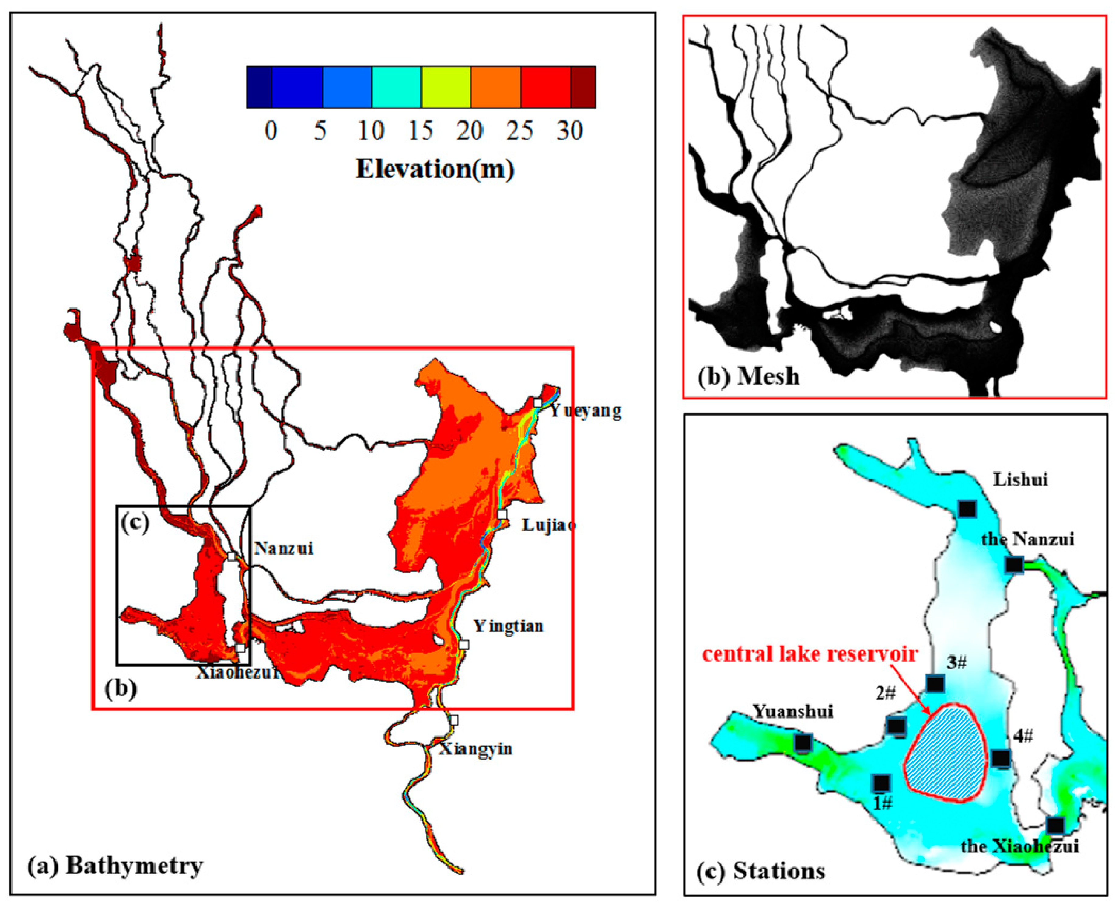
2. Model Description

2.1. Numerical Methods

Dongting Lake is generally shallow with an average water depth of six to seven meters [38]. Therefore, a 2D horizontal depth-averaged hydrodynamic model based on Mike 21 has been applied to investigate the flow characteristics in Dongting Lake. The governing equations of the numerical model in this paper are the two-dimensional depth-averaged continuity and momentum equations as below.
h t + h u ¯ x + h v ¯ y = 0
u ¯ t + u ¯ u ¯ x + v ¯ u ¯ y + g η x + g u ¯ u ¯ 2 + v ¯ 2 C 2 h = v t ( 2 u ¯ x 2 + 2 u ¯ y 2 )
v ¯ t + u ¯ v ¯ x + v ¯ v ¯ y + g η y + g v ¯ u ¯ 2 + v ¯ 2 C 2 h = v t ( 2 v ¯ x 2 + 2 v ¯ y 2 )
where t is time, x and y are Cartesian coordinate system coordinates, d is static water depth, η is water level, h = η + d is the total water depth, u and v are the corresponding velocity components in x and y directions, respectively, g is gravitational acceleration (m/s2), n is Manning coefficient, C is Chezy coefficient, and C = 1 n h 1 6 , v t is turbulence viscosity coefficient.
The hydrodynamic model in the MIKE21 FM is based on a flexible mesh approach. This model has been developed for applications within rivers, lakes, and coastal estuarine environments in China, such as Poyang Lake [39], Xiangjiang River [40], and Tieshan Bay [41]. The model is based on the solution of the incompressible Reynolds Averaged Navier-Stokes equations, which are subject to the assumptions of Boussinesq and hydrostatic pressure [42].

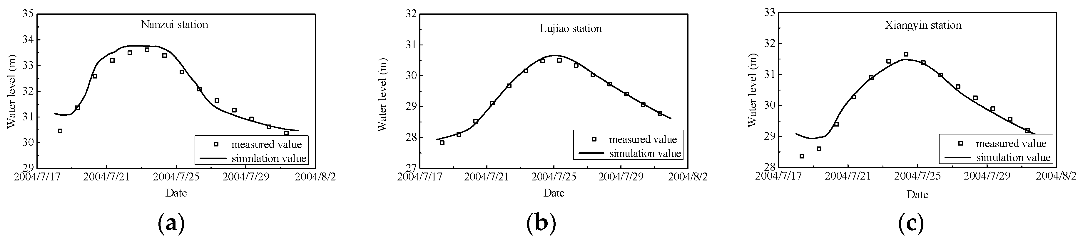
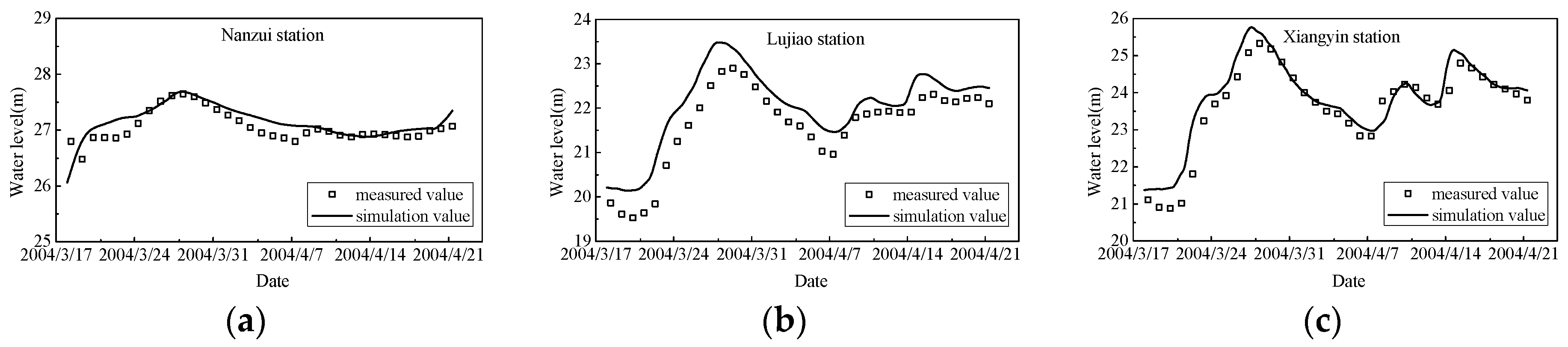
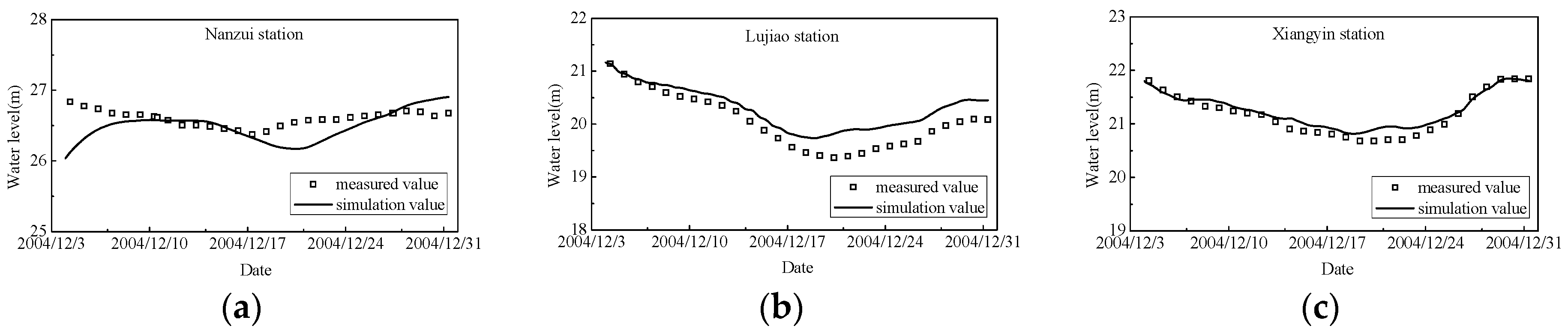
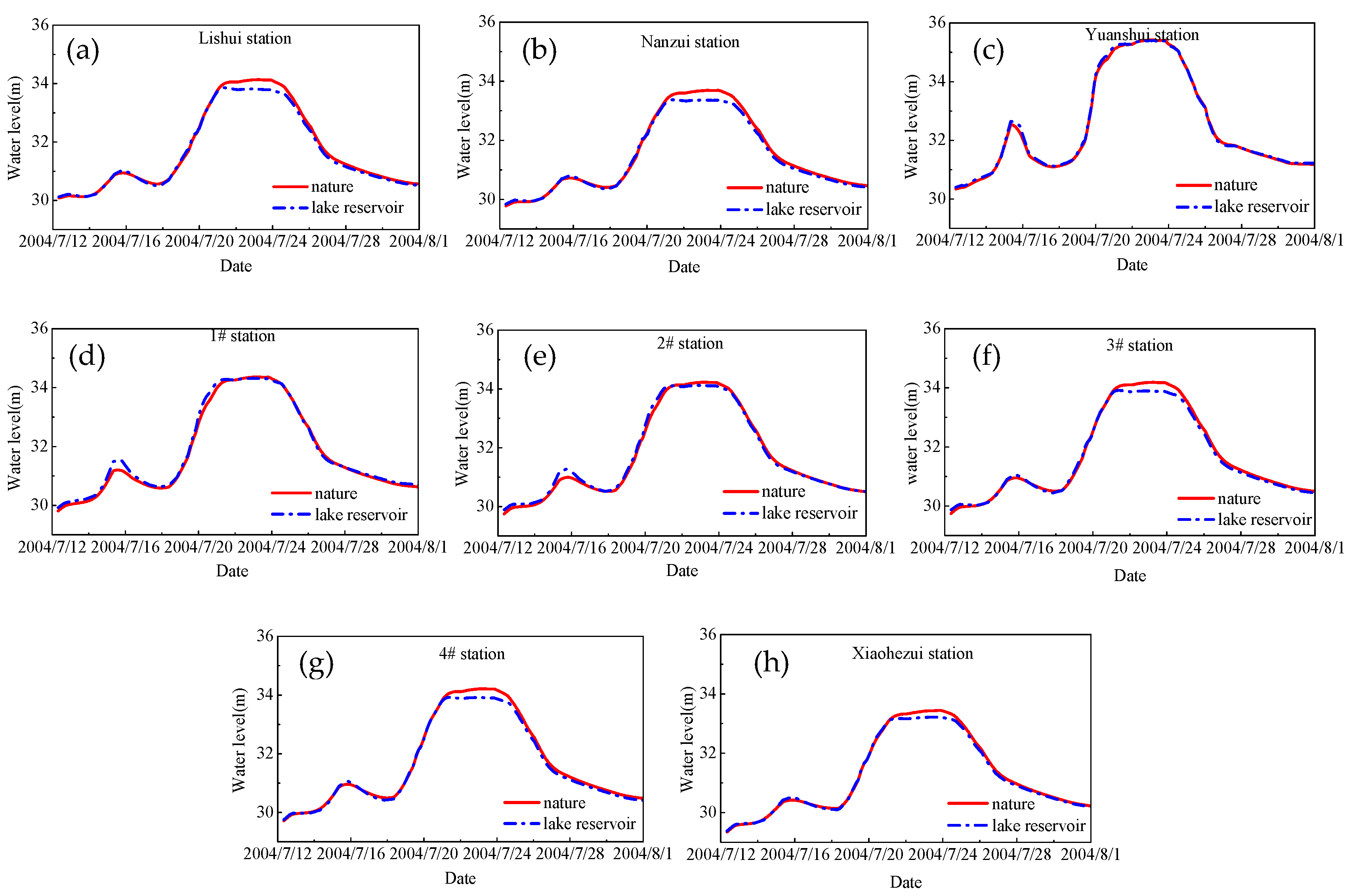
2.2. Model Validation

There are 403 river systems in the Dongting Lake District with a total length of more than five kilometers, which forms a very complex river network. The bathymetry distribution of the Dongting Lake District is shown in Figure 1a, which has 30 to 50 m resolution in most regions. The triangular mesh elements have been used to approximate the whole computational domain of Dongting Lake. To ensure the mesh quality, triangular element size is chosen based on the local topographic characteristics. High resolution mesh (about 30 m) is applied in the small river channels, the central lake reservoir, the regions with a large bed slope, and in the region with small bed slopes. Mesh elements with 500 m resolution are used, which is in Figure 1b. The whole computation mesh consists of 204,716 nodes and 462,082 elements.
In this study, it is assumed that the central lake reservoir is constructed in the West Dongting Lake, which is shown in Figure 1c. Its total surface area is about 4.37 km2. As depicted in Figure 1c, eight elevation stations are selected to analyze the variation of water elevation in the West Dongting Lake. Nanzui station and the Xiaohezui station are picked as the main flood control station. Li River station, Yuan River station, 1#, 2#, 3# and 4# are picked as the characteristic water elevation stations. The data recorded at these stations are used to analyze the variations of water elevation in West Dongting Lake since the construction of the central lake reservoir.
To validate the computational capability of our model, the water circulation process in the Dongting Lake region goes through three different time periods, which include the wet season (18 July, 2004 00:00–28 July, 2004 00:00), the normal season (19 March, 2004 00:00–21 April, 2004 00:00) and the dry season (4 December, 2004 00:00–21 December, 2004 00:00). The predicted water elevations are compared with the measured data at three selected stations (Nanzui, Lujiao and Xiangyin) as shown in Figure 2, Figure 3 and Figure 4 to account for the wet, normal and dry seasons, respectively. The minimum time step of the numerical integration is set to 0.01 s to maintain the Courant–Friedrich–Levy (CFL) condition for a stable solution [43].The running time for different time period is about 24 h (wet season), 72 h (normal season) and 72 h (dry season), which is calculated using a computer with i7-4790 CPU (3.6 GHz, Intel Core).The calculated values of the Coefficient of variation (Cv) of the water level at selected stations at different time periods are listed in Table 1. Most of them are less than 1.50% except for the water level at Lujiao station (i.e., Cv = 2.15%), which indicates that the predicted water elevations agree well with the observations.

3. Results and Discussion

3.1. The Central Lake Reservoir Effect

In this section, the hydrodynamic characteristics of the Dongting Lake after the construction of the central lake reservoir are discussed. The flow velocity contours are plotted in Figure 5 for different flood stages including the flood rise stage (18 July, 2004 08:00), flood peak stage (23 July, 2004 00:00), and the flood fall stage (27 July, 2004 05:00) in Dongting Lake without the central lake reservoir. As observed in Figure 5a, during the flood rising stage, it is shown that high flow velocity is formed in the main channel (0.8 m/s ~ 2.0 m/s), and the flow velocity in the rest of the region is between 0 and 0.2 m/s. At the flood peak stage, the flow velocity in the whole lake area increases significantly especially in the West Dongting Lake and the South Dongting Lake, which is shown in Figure 5b. However, in the flood fall stage, the flow velocity in the lake area decreases sharply (see Figure 5c).
Figure 6 depicts the contour of the velocity difference with and without the central lake reservoir for different flood stages including the flood rise stage (18 July, 2004 08:00), flood peak stage (23 July, 2004 00:00), and the flood fall stage (27 July, 2004 05:00) in Dongting Lake after the construction of the central lake reservoir. The area of the central lake reservoir equals 4.37 km2 and the height of the central lake reservoir is 12 m in this section. The flow velocity around the lake reservoir has increased in different degrees after the reservoir was built. During the peak time, the flow velocity increased about 0.5 m/s in the narrow channels between the central lake reservoir and the lake banks. This is due to the central lake reservoir reducing the discharge section area and the water being able to only flow between the lake reservoir and the embankments of the lake. For the rest of the region, the current speed does not change significantly.
Figure 7 plots the time series of water elevations at eight selected stations before and after the construction of the central lake reservoir. The existence of the central lake reservoir impacts the time series of water elevation separately at different station sites. The recorded water elevations decrease to some extent at Lishui, Nanzui, Xiaohezui, 3#, and 4# stations after the construction of the central lake reservoir. The decrease in water elevations ranges from 0.01 to 0.02 m. The recorded water elevations increase to some extent at Yuanshui, 1#, and 2# stations in the vicinity region of the central lake reservoir. The increase in water elevation ranges from 0.13 to 0.24 m. This is because the existence of the central lake reservoir has reduced the discharge section area, and the dammed water is observed at the upstream stations (Yuanshui, 1# and 2# stations). We demonstrate that water elevation of the downstream area and the northern region of West Dongting Lake decreases due to the water resistance of the reservoir.

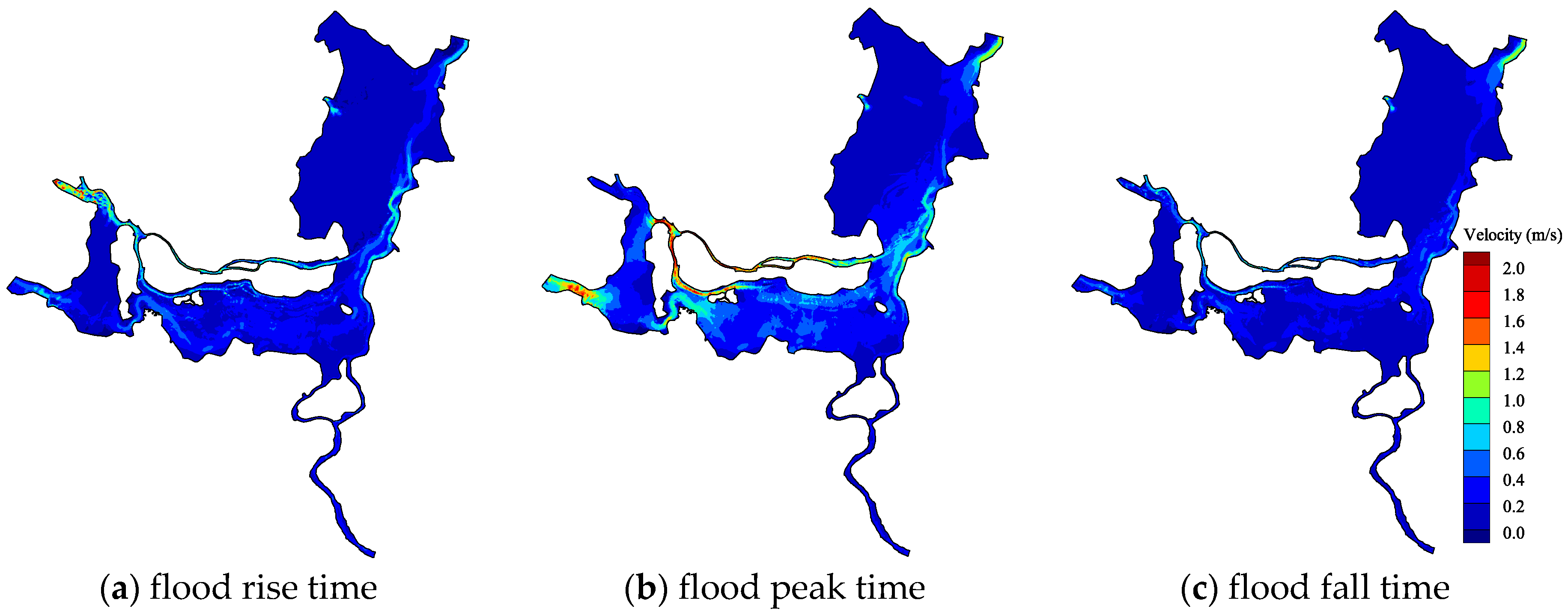
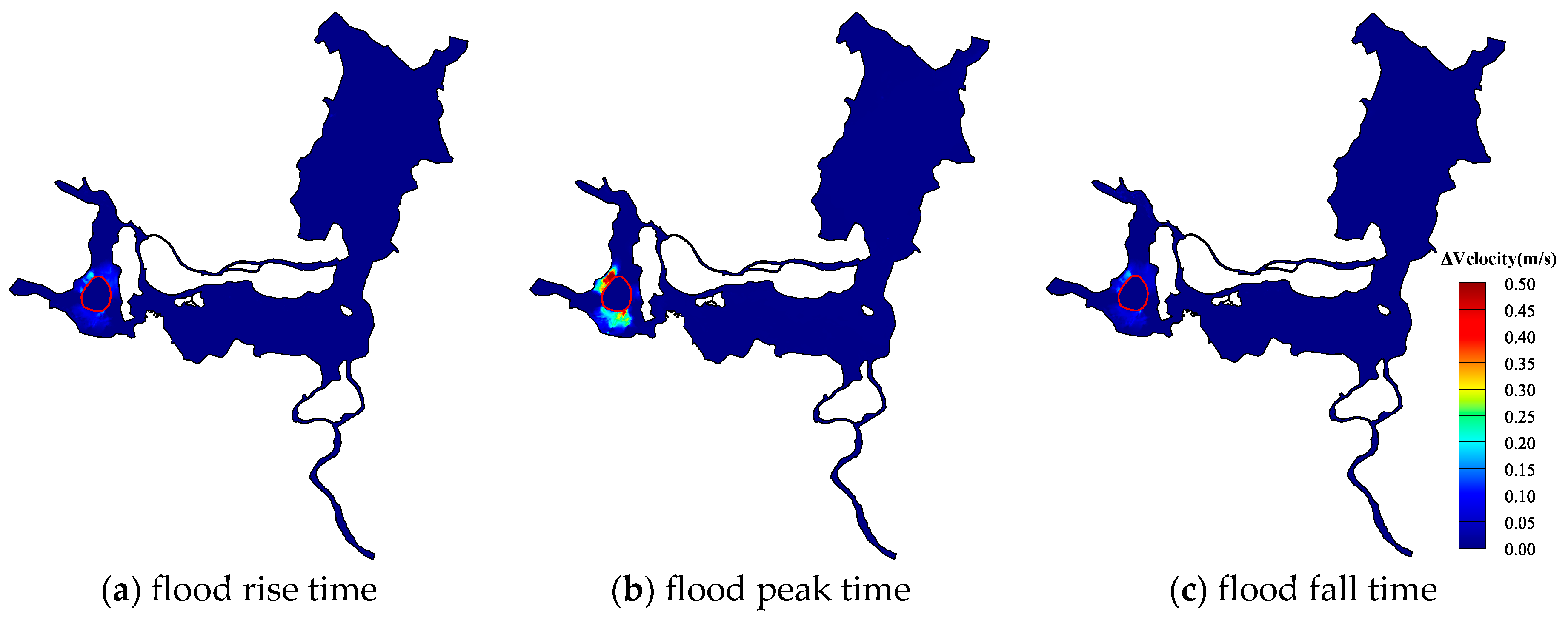
3.2. Flood Resistance Analysis

In order to alleviate the flood control pressure in the lake area during a flood event, the central lake reservoir begins to store flood water when the water elevation at characteristic sites reaches the warning water level. In this section, the effects of the central lake reservoir on the flood resistance of the Dongting Lake are discussed. To analyze the effects of the reservoir depth on flood resistance, three design depths were selected, which are 10 m, 12 m, and 15 m. Figure 8 plots the time series of water elevation at two main flood control stations (Nanzui and Xiaohezui stations) before and after the construction of the central lake reservoir in the West Dongting Lake between 12 July, 2004 to 1 August 2004. It is observed that, during the flood rising stage, the temporal variations of water elevation basically coincide for all of the situations. This is due to the fact that the central lake reservoir does not begin to store flood water at the flood rising stage. During the flood peak stage, the flood peak elevations at the two main flood control stations can be reduced significantly after the construction of the central lake reservoir. It was also observed that the design depth of the reservoir has a limited contribution to the reduction of the peak flood elevation if the design depth is larger than 10 m. In the flood decline stage, the existence of the central lake reservoir can speed up the flood releasing rate.
Table 2 shows the influence of different design depth on the peak flood elevation reduction at eight stations (Lishui, Nanzui, Yuanshui, 1#, 2#, 3#, 4#, and Xiaohezui). It can be seen from the table that the peak flood elevation at each site is clearly reduced by the central lake reservoir. The elevation reduction grows when the design depth increases. The construction of the central lake reservoir can relieve the flood control pressure of the lower reaches of the lake reservoir. Although the flood elevations at the Yuanshui, 1# and 2# stations can be somewhat affected by the central lake reservoir, the flood elevations at Lishui, Nanzui, 4#, and Xiaohekou stations can be influenced greatly by the central lake reservoir.

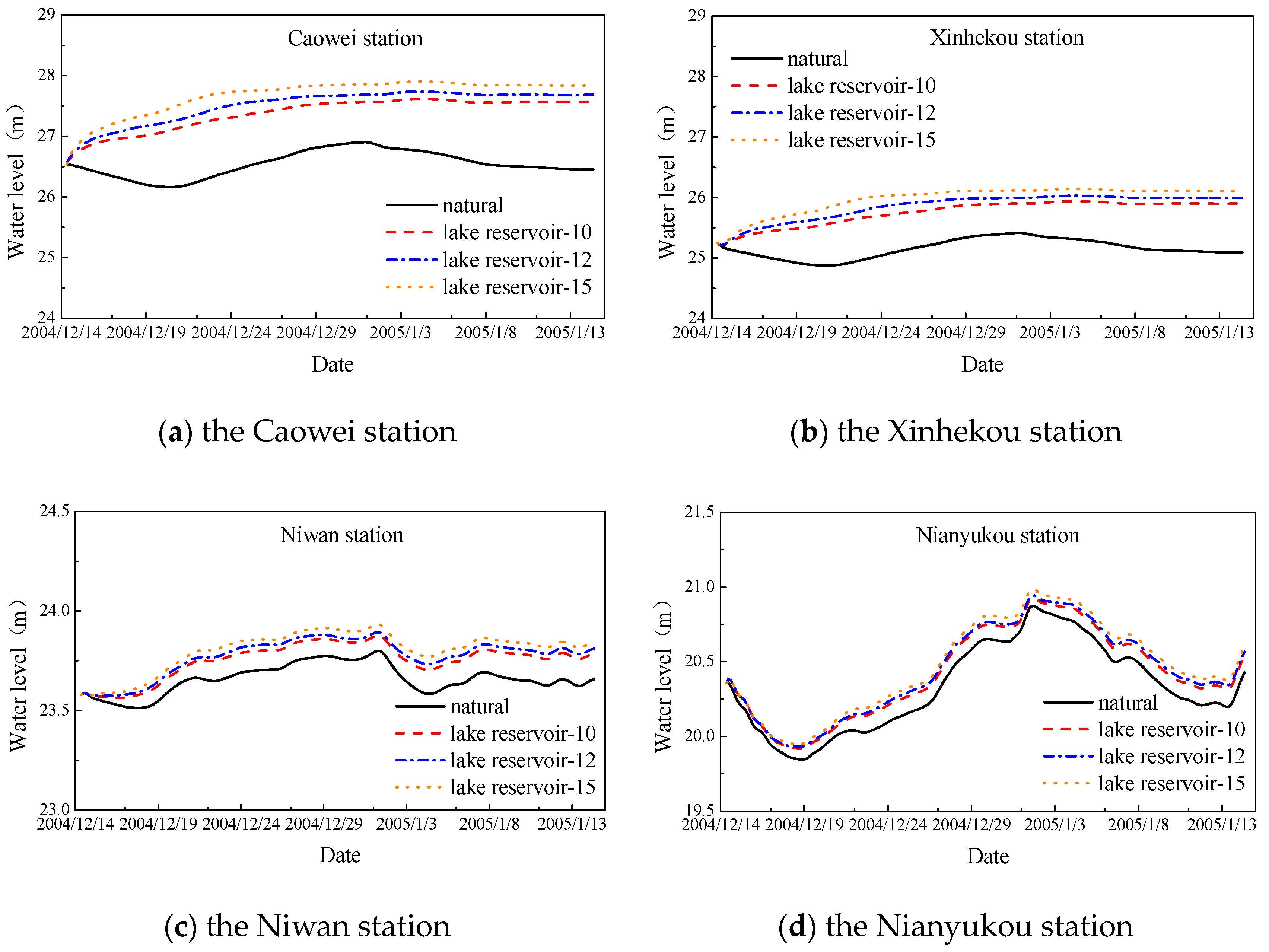
3.3. Drought Resistance Analysis

Once the central reservoir is completely filled, the gate of the training jetty will be closed. Then, the reservoir will store a large amount of water, which can be used to ensure that the Dongting Lake can have some drought resistance. Figure 9 plots the processing of water elevation along the Dongting Lake channel during the dry season (4 December, 2004 00:00- 14 January, 2005 00:00). The effects of the design depth (10 m, 12 m and 15 m) are also discussed in this section. As shown in Figure 9, the distribution of water elevation from the Caowei channel to the Luhu channel can be raised significantly by the supplemental water from the central lake reservoir. The supplemental water from the central lake reservoir can also increase the gradient of the water elevation along the Dongting Lake channel. The uplift value of water elevation also increases when the design depth of the central lake reservoir increases. However, a limited change in water elevation from the Luhu reach to the Zhanyukou reach can be observed.
To develop a detailed discussion on the impact of water replenishment from the central lake reservoir to the water level of the channel during the dry season, the time series of water elevation are selected at four stations, which include Caowei, Xinhekou, Niwan, and Nianyukou. The data are plotted in Figure 10 and the station locations are depicted in Figure 9. As shown in Figure 10a,b, after using the supplemental water from the central lake reservoir, the water levels during the dry season at the Caowei station and Xinhekou stations increase significantly.
Figure 10c,d plot the time series of water elevations at the Niwan and Nianyukou stations before and after water replenishment from the central lake reservoir. Since the Niwan station is located at the intersection of the Eastern Dongting Lake, its water elevation can be influenced by the Caowei, South Dongting Lake and Xiangjiang River. It is observed that the time series of the water elevation at the Niwan station is different from that of the upstream stations (the Caowei station and the Xinhekou station). The water level is relatively stable and maintained at about 23.6 m. The Nianyukou station is located in the East Dongting Lake, and its water level is influenced mainly by the South Dongting Lake and Xiangjiang River. Similar to the Niwan station, the Nianyukou station is only somewhat influenced by the water replenishment of the central lake reservoir. However, the water level at the Nianyukou station does increase to some extent. The average rise of water level of the Niwan station and the Nianyukou station is about 0.10–0.15 m. Additionally, the water elevations at all of the stations tend to increase during the dry season. There is no doubt that the water replenishment from the central lake reservoir can significantly enhance the drought resistance of the Dongting Lake.

4. Conclusions

In the past, a large amount flood water flowed into the lake, which resulted in flood disaster in the lake area during the rainy season. However, the lake area also faces a water crisis during the drier months. If the central lake reservoir is constructed, surplus flood water could be stored in the central lake reservoir which would to mitigate the flood disaster during rainy season. Additionally, water stored during the flood season can be used to relieve the nearby water supply stress during the dry season. Therefore, this is a win-win situation once the central lake reservoir is developed. The feasibility of the central lake reservoir has been verified by series simulations carried out by a shallow water model. We believe that the results and discussion presented in this paper have important implications for policy makers and their management of Dongting Lake. The main conclusions are below:
(1)
The replenishment of the central lake reservoir can increase the water exchange rate in the Kaihu channel and the Xiangjiang River downstream channel. Therefore, it is favorable for reducing the risk of water eutrophication and improving the water environment in the channel.
(2)
The existence of the central lake reservoir can effectively reduce the peak flood water level in the West Dongting Lake, and finally reduce the flood pressure.
(3)
The capacity of water storage of the central lake reservoir during the dry season can efficiently increase the lake water level in the upstream channel and thereby, enhance the drought resistance of the lake area.
(4)
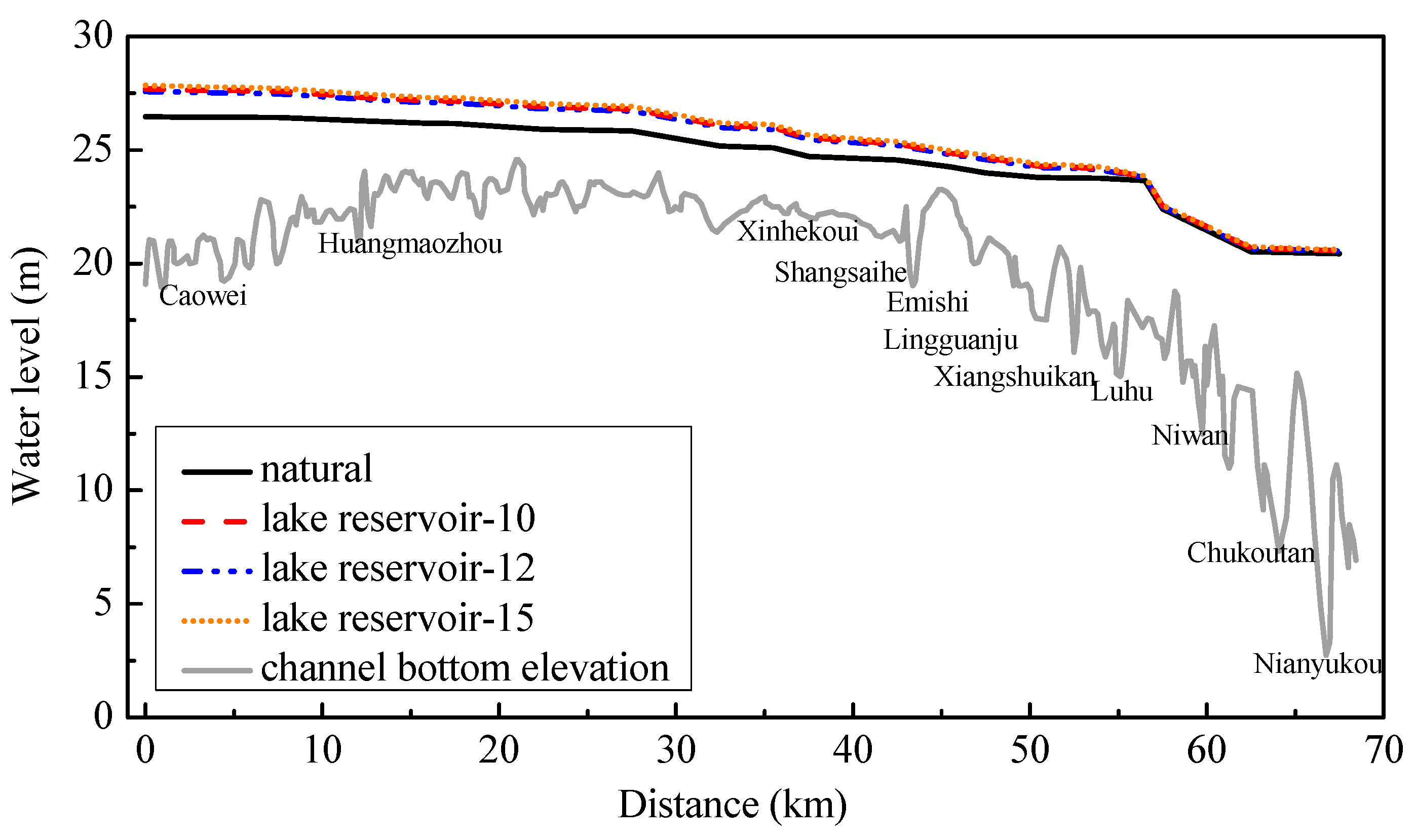
It is also observed that the design depth of the reservoir makes a limited contribution to the reduction of the peak flood elevation if the design depth is larger than 10 m. The uplift value of water elevation also increases when the design depth of the central lake reservoir increases.

Acknowledgments

This research was partially supported by the National Natural Science Foundation of China (51509023), the Natural Science Foundation of Hunan Province, China (2018JJ3535, 2016JJ3011 and 2016WK2017), the Scientific Research Fund of Hunan Provincial Education Department, China (16C0056), and the Open Fund Program of Key Laboratory of Water & Sediment Science and Water Hazard Prevention, Changsha University of Science & Technology (2017SS05). The second author was partially supported by the China Scholarship Council. We received funds for covering the costs to publish in open access.

Author Contributions

Huying Liu and Bin Deng analyzed the data and wrote the manuscript. Changbo Jiang put forward the framework of this study and revised the manuscript. YuannanLong and Zhiyuan Wu designed the modeling approach. Yizhuang Liu implemented the hydraulic model.

Conflicts of Interest

The authors declare no conflict of interest. The founding sponsors had no role in the design of the study. in the collection, analyses, or interpretation of data, in the writing of the manuscript, or in the decision to publish the results.

References

  1. Schneider, P.; Hook, S.J. Space observations of inland water bodies show rapid surface warming since 1985. Geophys. Res. Lett. 2010, 37, 208–217. [Google Scholar] [CrossRef]
  2. O’Reilly, C.M.; Sharma, S.; Gray, D.K.; Hampton, S.E.; Read, J.S.; Rowley, R.J.; Schneider, P.; Lenters, J.D.; McIntyre, P.B.; Kraemer, B.M.; et al. Rapid and highly variable warming of lake surface waters around the globe. Geophys. Res. Lett. 2015, 42. [Google Scholar] [CrossRef]
  3. Rose, K.C.; Winslow, L.A.; Read, J.S.; Hansen, G.J. Climate-induced warming of lakes can be either amplified or suppressed by trends in water clarity. Limnol. Oceanogr. Lett. 2016, 1, 44–53. [Google Scholar] [CrossRef]
  4. Woolway, R.I.; Merchant, C.J. Amplified surface temperature response of cold, deep lakes to inter-annual air temperature variability. Sci. Rep. 2017, 7, 4130. [Google Scholar] [CrossRef] [PubMed]
  5. Woolway, R.I.; Dokulil, M.T.; Marszelewski, W.; Schmid, M.; Bouffard, D.; Merchant, C.J. Warming of Central European lakes and their response to the 1980s climate regime shift. Clim. Change 2017, 142, 505–520. [Google Scholar] [CrossRef]
  6. Goldman, C.R.; Michio, K.; Richard, D.R. Climatic change and global warming of inland waters: impacts and mitigation for ecosystems and societies. John Wiley & Sons: New York, NY, USA, 2012. [Google Scholar]
  7. Fukushima, T.; Ozaki, N.; Kaminishi, H.; Harasawa, H.; Matsushige, K. Forecasting the changes in lake water quality in response to climate changes, using past relationships between meteorological conditions and water quality. Hydrol. Process. 2015, 14, 593–604. [Google Scholar] [CrossRef]
  8. Larsen, J. Disappearing lakes, shrinking seas. Eco-Econ. Update 2005, 3. Available online: http://www.earth-policy.org/ plan_b_updates/2005/update47 (accessed on 1 December 2017).
  9. Du, Y.; Xue, H.P.; Wu, S.J.; Ling, F.; Xiao, F.; Wei, X. Lake area changes in the middle Yangtze region of China over the 20th century. J. Environ. Manag. 2011, 92, 1248–1255. [Google Scholar] [CrossRef] [PubMed]
  10. Wurtsbaugh, W.A.; Miller, C.; Null, S.E.; DeRose, R.J.; Wilcock, P.; Hahnenberger, M.; Howe, F.; Moore, J. Decline of the world's saline lakes. Nature Geosci. 2017, 10, 816. [Google Scholar] [CrossRef]
  11. Dugan, H.A.; Bartlett, S.L.; Burke, S.M.; Doubek, J.P.; Krivak-Tetley, F.E.; Skaff, N.K.; Summers, J.C.; Farrell, K.J.; McCullough, I.M.; Morales-Williams, A.M.; et al. Salting our freshwater lakes. Proc. Natl. Acad. Sci. USA 2017, 114, 4453–4458. [Google Scholar] [CrossRef] [PubMed]
  12. Chen, J.L.; Pekker, T.; Wilson, C.R.; Tapley, B.D.; Kostianoy, A.G.; Cretaux, J.F.; Safarov, E.S. Long-term Caspian Sea level change. Geophys. Res. Lett. 2017, 44, 6993–7001. [Google Scholar] [CrossRef]
  13. Wang, S.; Meng, W.; Jin, X.; Zheng, B.; Zhang, L.; Xi, H. Ecological security problems of the major key lakes in China. Environ. Earth Sci. 2015, 74, 3825–3837. [Google Scholar] [CrossRef]
  14. Nakayama, T.; Watanabe, M. Role of flood storage ability of lakes in the Changjiang River catchment. Glob. Planet. Change 2008, 63, 9–22. [Google Scholar] [CrossRef]
  15. Yahaya, S.; Ahmad, N.; Abdalla, R.F. Multicriteria analysis for flood vulnerable areas in Hadejia-Jama’are River basin, Nigeria. Eur. J. Sci. Res. 2010, 42, 71–83. [Google Scholar]
  16. Henny, C.; Meutia, A.A. Urban lakes in Megacity Jakarta: risk and management plan for future sustainability. Procedia Environ. Sci. 2014, 20, 737–746. [Google Scholar] [CrossRef]
  17. Li, Y.S.; Raso, G.; Zhao, Z.Y.; He, Y.K.; Ellis, M.K.; McManus, D.P. Large water management projects and schistosomiasis control, Dongting Lake region, China. Emerg. Infect. Dis. 2007, 13, 973. [Google Scholar] [CrossRef] [PubMed]
  18. Osti, R.; Egashira, S. Hydrodynamic characteristics of the Tam Pokhari Glacial Lake outburst flood in the Mt. Everest region, Nepal. Hydrol. Process. 2009, 23, 2943–2955. [Google Scholar] [CrossRef]
  19. Xu, X.; Liu, Q. Numerical study on the characteristics of wind-induced current in Taihu Lake. J. Hydrodyn. (Ser. A) 2009, 4, 018. [Google Scholar]
  20. Paerl, H.W.; Xu, H.; McCarthy, M.J.; Zhu, G.; Qin, B.; Li, Y.; Gardner, W.S. Controlling harmful cyanobacterial blooms in a hyper-eutrophic lake (Lake Taihu, China): the need for a dual nutrient (N & P) management strategy. Water Res. 2011, 45, 1973–1983. [Google Scholar] [PubMed]
  21. Sun, Z.; Huang, Q.; Opp, C.; Hennig, T.; Marold, U. Impacts and implications of major changes caused by the Three Gorges Dam in the middle reaches of the Yangtze River, China. Water Resour. Manag. 2012, 26, 3367–3378. [Google Scholar] [CrossRef]
  22. Liu, J.; Dietz, T.; Carpenter, S.R.; Alberti, M.; Folke, C.; Moran, E.; Pell, A.N.; Deadman, P.; Kratz, T.; Lubchenco, J.; et al. Complexity of coupled human and natural systems. Science 2007, 317, 1513–1516. [Google Scholar] [CrossRef] [PubMed]
  23. Wan, R.; Yang, G.; Wang, X. Progress of research on the relationship between the Yangtze River and its connected lakes in the middle reaches, China. J. Lake Sci. 2014, 26, 1–8. [Google Scholar]
  24. Niu, X. Integrated management strategies for Dongting Lake, China. J. Hydroelectr. Eng. 2007, 80, 1–7. [Google Scholar]
  25. Tang, R. Impact of river bend cut-off of lower Jingjiangriver on the river and Dongtinglake, China. Yangtze River 1999, 30, 24–26. [Google Scholar]
  26. Hu, Q.; Feng, S.; Guo, H.; Chen, G.; Jiang, T. Interactions of the Yangtze river flow and hydrologic processes of the Poyang Lake, China. J. Hydrol. 2007, 347, 90–100. [Google Scholar] [CrossRef]
  27. Chen, J. An approach on flood control strategy in middle and lower reaches of Yangtze River after the completion of the Three Gorges Dam project, China. Adv. Water Sci. 2014, 25, 745–751. [Google Scholar]
  28. Lai, H.; Mo, D.; Su, C. Discussion on the evolutionary trend of Lake Dongting, China. Geograph. Res. 2004, 23, 78–86. [Google Scholar]
  29. Jiang, J.; Huang, Q.; Sun, Z. Study on sediment deposition and continental beach change in dongting lake, China. Yangtze River 2009, 40, 74–75. [Google Scholar]
  30. Lu, C. The relationship between dongting lake governance and jianghu, China. Hunan Hydro & Power 2005, 50, 13–15. [Google Scholar]
  31. Li, J.; Wang, K.; Qin, J. The Evolution of Annual Runoff and Sediment in the Dongting Lake and Their Driving Foeces, China. Acta Geographica Sinica 2005, 60, 503–510. [Google Scholar]
  32. Zhang, O.; Xiong, M. Analysis on the variation and influencing factors of sediment release ratio in Dongtinglake, China. Yangtze River 2006, 37, 117–119. [Google Scholar]
  33. Li, Z.; Xie, Y.; Xu, D. Runoff-sediment Variation and Its Effect on the Dongting Lake, China. J. China Hydrol. 2011, 31, 010. [Google Scholar]
  34. Xie, Y.; Li, F.; Chen, X. Study on the Minimum Ecological Water Demand for the Dongting Lake, China. Resour. Environ. Yangtze Basin 2012, 21, 64–70. [Google Scholar]
  35. Wang, X.; Li, X.; Wu, Y. Maintaining the connected river-lake relationship in the middle Yangtze River reaches after completion of the Three Gorges Projec. Int. J. Sediment Res. 2017, 32, 487–494. [Google Scholar] [CrossRef]
  36. Deng, M.; Yi, F.; Luan, Z. Analysis of impacts on Dongting Lake by flood control of Songzi sluice under operation of Three Gorges project. J. Hydroelectr. Eng. 2013, 32, 156–162. [Google Scholar]
  37. Xu, H.; Xu, D.; Xiao, H. Discussion on the utilization of water resources in four water system in Dongtinglake. Express Water Resour. Hydropower Inf. 2013, 34, 13–16. [Google Scholar]
  38. Zheng, M.H.; Zhang, B.; Bao, Z.C.; Yang, H.; Xu, X.B. Analysis of pentachlorophenol from water, sediments, and fish bile of Dongting Lake in China. Bull. Environ. Contam. Toxicology 2000, 64, 16–19. [Google Scholar] [CrossRef]
  39. Li, Y.; Yao, J. Estimation of transport trajectory and residence time in large river–lake systems: application to Poyang Lake (China) using a combined model approach. Water 2015, 7, 5203–5223. [Google Scholar] [CrossRef]
  40. Long, Y.; Wu, C.; Jiang, C.; Hu, S.; Liu, Y. Simulating the Impacts of an Upstream Dam on Pollutant Transport: A Case Study on the Xiangjiang River, China. Water 2016, 8, 516. [Google Scholar] [CrossRef]
  41. Jiang, C.; Liu, Y.; Long, Y.; Wu, C. Estimation of Residence Time and Transport Trajectory in Tieshangang Bay, China. Water 2017, 9, 321. [Google Scholar] [CrossRef]
  42. MIKE21, D.H.I.; MIKE3 Flow Model, F.M. Hydrodynamic and Transport Module Scientific Documentation. Denmark:DHl water Environ. 2009. [Google Scholar]
  43. Danish Hydraulic Institute (DHI). MIKE 21 Flow Model: Hydrodynamic Module User Guide; DHIWater and Environment: Hørsholm, Denmark, 2014. [Google Scholar]
Figure 1. (a) The bathymetry distribution of Dongting Lake District; (b) Layout of computational mesh; (c) Distribution of stations (filled black squares).
Water 10 00225 g001
Figure 2. Comparisons of time series of water elevation between predictions and measurement during the wet season. (a) the Nanzui station; (b) the Lujiao station; (c) the Xiangyin station.
Water 10 00225 g002
Figure 3. Comparisons of time series of water elevation between predictions and measurement during the normal season. (a) the Nanzui station; (b) the Lujiao station; (c) the Xiangyin station.
Water 10 00225 g003
Figure 4. Comparisons of time series of water elevation between predictions and measurement during the dry season. (a) the Nanzui station; (b) the Lujiao station; (c) the Xiangyin station.
Water 10 00225 g004
Figure 5. The flow velocity contour without the construction of the central lake reservoir (unit: m/s)
Water 10 00225 g005
Figure 6. The change of flow velocity contour with the central lake reservoir (unit: m/s).
Water 10 00225 g006
Figure 7. The time series of water elevations recorded at eight selected stations.
Water 10 00225 g007
Figure 8. The time series of water elevation at two main flood control stations in the West Dongting Lake.
Water 10 00225 g008
Figure 9. The distribution of the processing water elevation along the Dongting Lake channel.
Water 10 00225 g009
Figure 10. The time series of water elevation at different sites under different design depth during the dry season.
Water 10 00225 g010
Table 1. The values of Cv calculated at the selected stations in the Dongting Lake area during different time periods.
Coefficient of variation (%)NanzuiLujiaoXiangyin
Wet season0.800.410.77
Normal season0.602.151.45
Dry season0.861.500.56
Table 2. The influence of different design depth on the peak water elevation (m).
StationMeasure valueThe Design Depth of the Middle Lake Reservoir
10 m12 m15 m
Water levelWater levelDifference valueWater levelDifference valueWater levelDifference value
Lishui34.1433.81−0.3333.74−0.433.73−0.41
Nanzui33.6933.36−0.3333.31−0.3833.3−0.39
Yuanshui35.4335.4−0.0335.36−-0.0735.34−0.09
1#34.3634.32−.0434.24−0.1234.22−0.14
2#34.2334.12−0.1134.05−0.1634.02−0.21
3#34.1733.89−0.2833.82−0.3533.81−0.36
4#34.2233.92−0.3033.85−0.3733.84−0.38
Xiaohezui33.4433.22−0.2233.2−0.2833.16−0.29
Notice: The positive values indicate rising water level and the negative values indicate falling water level.

