Case Study on Water Quality Improvement in Xihu Lake through Diversion and Water Distribution

SKLOE, CISSE, School of Naval Architecture, Ocean and Civil Engineering, Shanghai Jiao Tong University, Shanghai 200240, China
*
Author to whom correspondence should be addressed.
Water 2018, 10(3), 333; https://doi.org/10.3390/w10030333
Submission received: 25 January 2018
/
Revised: 15 March 2018
/
Accepted: 15 March 2018
/
Published: 16 March 2018
(This article belongs to the Special Issue Eutrophication Management: Monitoring and Control)
Abstract
:Eutrophication in lakes and reservoirs is a serious environmental problem that has damaged ecosystem health worldwide. Water diversion is one of the most popular methods for improving the water quality in shallow lakes, as it dilutes pollutants in and diverts them out of the lake. However, simple diversion without rational water distribution cannot significantly enhance water exchange in the entire lake because dead water zones always exist. This paper illustrates a case study on water quality improvement in Xihu Lake by diversion and water distribution. Based on theoretical calculation, the diversion water discharge was determined and rationally distributed into four different locations. According to the field observations after the implementation of the diversion and water distribution project, the average velocity over the dead water zones increased approximately 50 times over that of prior to the project. The average water exchange period reduced from 68 days to 22.5 days. The average turbidity was 8.8% and 12.4% lower than before after two and four months of diversion, respectively. The maximum turbidity reduced from the original 27.5 NTU (Nephelometric Turbidity Unit) to 20.1 NTU after two months of diversion, then to 16.1 NTU after four months of diversion. It shows that this diversion and rational water distribution eliminates most of the dead water zones and achieves a favorable flow field, thus reducing the turbidity and increasing water transparency, which is conducive to the improvement of water quality.
1. Introduction
Eutrophication in lakes and reservoirs is a serious environmental problem that damages ecosystems worldwide [1,2,3]. In shallow unstratified lakes, it is more difficult to decrease algal biomass and increase transparency than in deep stratified lakes [4,5]. Consequently, the control and prevention of shallow lake eutrophication have attracted the attention of scientists, the public, local authorities, and governments. In general, methods to improve water quality in shallow lakes mainly are divided into three categories: biological [6,7,8,9,10], chemical [11,12,13], and physical [14,15,16,17,18,19]. Among these methods, water diversion has been proposed as an important physical method for lake restoration [20,21]. Water diversion diverts clean and low-nutrient water to a eutrophic lake in order to improve the water quality [22]. The theory behind this mechanism is that adding large amounts of low-nutrient water not only can dilute the pollution in a lake, but also accelerate water exchange and eliminate dead water zones in the water body. The advantages of water diversion are that it is low cost, easy to conduct, and can show a quick response in nutrient reduction when a suitable quantity of dilution water is available [23].
In many countries, water diversions have been successfully implemented to improve water quality in lakes. Examples include Moses Lake in Washington, DC, USA, into which a large volume of low-nutrient water from the Columbia River was introduced during the spring and summer of 1977 [24,25]; another water project in the United States that involved diverting the Mississippi River into Lake Pontchartrain [26,27]; and a diversion project for Lake Veluwe in Holland [28]. In Canada, water has been diverted from the Red Deer River to Alix Lake by eight kilometers of pipelines, channels, and small ponds [29]. Although comparative pre-diversion data are limited, it appears that the diversion has had a positive influence on the recreational water quality of Alix Lake since 1997, and the annual diversion volumes have risen from 6.8 million m3 in 2000 to 15.4 million m3 in 2001. Enhanced flushing from the diversion has generally reduced phosphorus and chlorophyll concentrations in the lake. Since the 1990s in China, the pollution in large shallow lakes such as Lakes Taihu, Dianchi, Xuanwu, Xihu, and Jinshan also has been diluted through diversion projects, and positive results regarding water quality were achieved [20,30,31,32,33]. For example, the aim of the Yangtze River water diversion project was to enhance water exchange in Taihu Lake 2, which is the third largest freshwater lake in China [34]. Water transfer from the Yangtze River was initiated in 2002 to dilute polluted water in the lake and to accelerate the flushing of pollutants and algae out of the lake. The main route of the original water transfer brought fresh water from the Yangtze River into Taihu Lake via the Wangyu River and took water out of the lake through the Taipu River. To date, four different routes have been implemented. The diversion from the Yangtze to rescue Taihu Lake has improved the water quality of Taihu Lake and its affiliated networks while also increasing the carrying capacity of water resources in the Taihu Lake Basin [35,36].
However, some diversions improve water quality only marginally; they cannot significantly enhance water exchange in the entire lake, thus heavily polluted areas still exist [37]. For example, Zhai et al. [38] assessed ecosystem health based on the ecological indicators: the exergy, structural exergy, phytoplankton buffer capacity, and trophic state index. Exergy expresses the biomass of the lake system and the information that the biomass is carrying. Structural exergy is defined as exergy divided by the total biomass. It expresses the dominance of the higher organisms and measures the ability of the ecosystem to utilize the available resources. The phytoplankton buffer capacity is the ability of water to resist changes in pollutant concentration. The trophic state index expresses the quantities of nitrogen, phosphorus, and other biologically useful nutrients of the water body. An ecosystem with high exergy, high structural exergy, high buffer capacities and low trophic state index could be considered to be of good health. The results showed that the original Yangtze River diversion had a positive effect on water quality only in parts of the lake, such as Gonghu Bay and the northwest, southwest and central zones, but had no significant effect on Meiliang Bay based on regression analysis of long-term data. The original Yangtze River diversion may have alleviated the eutrophication issue in parts of the lake, but it has not substantially enhanced water exchange in Meiliang and Zhushan Bays [39]. The improvement in water quality from these diversion projects did not afford sufficient benefits. The defect of current diversion projects is that the diversions generally have only one outlet so that the diverted clean water always forms a main current that flows faster through the lake. In such situations, the flow field of the lake may not be ideally reconstructed. Namely, some dead water zones still exist where water runs quite slow or even stagnates, hence the diverted clean water cannot fully flush out the turbid water [37]. The diverted water needs to be properly distributed to various key locations to holistically enhance water exchange in the system [21]. Thus, it is necessary to investigate the proper mode of water diversion and distribution.
This case study concerns the water diversion and distribution project that has been successfully implemented in Beili Lake, which is part of Xihu Lake. In this case, the clean water was diverted from Xili Lake through one input and was systematically distributed to four outputs to fully reconstruct the flow field of Beili Lake.
2. Materials and Methods
2.1. Study Area
Xihu Lake is located in the city of Hangzhou in Zhejiang Province and has an area of 6.5 km2 and a perimeter of about 15 km. The lake consists of the main lake, Beili Lake, Xili Lake, Xiaonan Lake, and Yue Lake, as shown in Figure 1.
The bed of Xihu Lake is relatively flat, with sediment that mainly contains high organic limnic deposition, and silty clay loam. The area of the Xihu Lake basin is about 21.22 km2, and the annual runoff is 14 million m3. The water capacity of the entire lake is about 16.25 million m3 when the water level is maintained at the Yellow Sea elevation of 7.18 + 0.05 m, and the water storage capacity is nearly 10 million m3. The natural exchange frequency of water is 2 times/year [40].
In September 1986, the Hangzhou municipal government completed sewage interception and diversion works for Xihu Lake. Since then, diversion from the Qiantang River has a water discharge of 3 × 10⁵ m3/day to Xihu Lake. Later, two pretreatment sedimentation tanks employing the flocculation precipitation method were built to purify the diverted water, and their daily processing capacities were 3 × 10⁵ m3/day and 1 × 10⁵ m3/day. With these pretreatment sedimentation tanks, the raw water was purified, so that the water quality into the lake was greatly improved [20]. The diversion of 4 × 10⁵ m3 water per day from the Qiantang River altered the original water exchange rate of Xihu Lake from once a year to once a month. As shown in Figure 1, five inlets and nine outlets are located in the shoreline; their discharges are listed in Table 1. However, places such as the southeast corner of the lake, Beili Lake, and the southwest region of Yue Lake, where the concentration of total phosphorus (TP) has not been reduced, are the dead corners of the diversion works.
Beili Lake is located in the northern part of Xihu Lake. It has a total water surface area of 0.27 km2 and an average water depth of 2.2 m. Under normal circumstances, the lake has a total storage capacity of about 49 million m3. Beili Lake connects to Xihu Lake through three tunnels and bridges. A small outlet pipeline discharges the lake water into the sewage system. The flow in Beili Lake is very slow, water exchange cycle is long, and the water quality is rather poor (Bad V class according to Chinese water quality standards [41] as shown in Table 2).
2.2. Requirements for Diversion and Water Distribution
To improve the water quality of eutrophic lakes, the concentrations of phosphorus and nitrogen need to be reduced and controlled. Biologically, nitrate can be absorbed by aquatic plants, which are artificially planted in shallow rivers, canals, and lakes, as shown in Figure 2. In addition, the pollutants can also be degraded by microorganisms. It should be noted that nitrate is very soluble, which is generally detrimental to plants [42]. Hydraulically, these constituents can be washed away from their places of production and be diluted by a large amount of water. The advection–diffusion equation for a pollutant can be expressed by
where S is the concentration of the pollutant, i.e., inorganic forms of either phosphorus or nitrogen; U, V, and W are the flow velocities in the x, y, and z directions, respectively; ν is the diffusion coefficient of the pollutant; k is the biodegradation rate of the pollutants, which represents the capability of bacteria, fungi, or other biological means to disintegrate pollutants; q is the source, which may be linked with atmospheric deposition and release from bottom sediments; and x, y, and z are the relative coordinates of the pollutant source in the Cartesian coordinates.
However, many dead water zones generally exist where flow velocity is null in shallow lakes, such as Xihu Lake. Within the dead water zones, flow velocities U, V, and W, respectively, in the x, y, and z directions are zero. In other words, the advection term inside the dead water zones is zero. Then, Equation (1) becomes:
Comparing Equations (1) and (2), the following can be seen. (1) In a running flow field, the flow provides advection hydrodynamics, which takes pollutants away from their production places, akin to the Chinese idiom that running water never gets stale. The higher the flow velocities are, the faster the pollutants are taken away; (2) In the dead water zone, without the advection provided by the flow, the concentration of pollutant mainly changes via diffusion and the absorption by the aquatic plants. Because of the small magnitude of the diffusion coefficient, the amount of pollutant passing through the boundary of the dead water zone would be very small. In other words the exchange of pollutant between the outer and inner layers of the dead water zone can be regarded as null; (3) In the dead water zone, the concentration of the pollutant would gradually increase with time, i.e., the water quality would become increasingly worse over time unless a sufficient quantity of aquatic plants is implanted therein. Hence, to reduce the concentration of pollutants and improve the water quality in lakes, the dead water zone should be eliminated.
2.3. Hydrological Calculations of Diversion Discharge
The flow velocity in Beili Lake is very low, such that the lake is almost a stagnant water body. Under such flow conditions, the turbidity in Beili Lake cannot decrease if there is no diversion. The suspension and transport of bottom mud in Beili Lake are mainly due to wind and current. When the maximum orbital velocity (Ubmax) of water particles from wave motion is higher than the threshold velocity (Uc) of the bottom sediments, the bottom sediments will be suspended. However, the orbital velocity (Ub) can only suspend sediments vertically. The velocities of Stokes drift (Ut) and wind driven current (Uw) cause sediment transport. Thus, the required amount of diverted water can be calculated as follows.
When no sediment is coming in, the movement of bottom sediment in the lake is in equilibrium, meaning that the amounts of suspended and settled sediments in a unit time are equal. Thus, the sediment transport rate per unit width (qs) is
where , C is the Chezy’s coefficient, Kb is the sediment transport coefficient, Kb = (0.12~0.18) [43], γs is the specific weight of sediments, γ is the specific weight of water, Vm is the resultant velocity of the velocities of Stokes drift and wind driven current, and ω is the sediment settling velocity.
The orbital velocity of particles due to wave motion averaged over half a period can be calculated using [44]
where H is the wave height, T is the wave period, L is the wave length, and h is the water depth. The Stokes drift velocity (the wave velocity of mass transfer) averaged over a wave period is
where c is the wave speed. According to technological specification of harbor engineering [45], the velocity of wind driven current is
where Vw is the wind speed. Thus, the resultant velocity Vm is
When the median grain size (d50) of sediments is less than 0.03 mm, the fine sediments are flocculated, with the settling velocity of flocculating sediments [46] calculated using
According to the method proposed by Teng et al. [47], the wave elements of wind waves can be calculated as
where F is the fetch length.
The area of Beili Lake is 0.27 km2; the average water depth is 2.2 m; and, generally, the total water storage is 4.9 × 10⁴ m3. Based on the results of sampling and grain analysis, the median grain size of the bottom mud in Beili Lake is 0.003 mm. The annual average wind velocity is 1.3–2.4 m/s, and the constant wind velocity is chosen as 2.25 m/s, which is the maximum value of the monthly averaged velocity. Therefore, based on Equations (3)–(11), it can be calculated that about 186.36 kg sediments could be suspended from the bottom of Beili Lake every day. The amount of diverted water and drained water should be the same. Meanwhile, the drained water should meet the water quality requirement for turbidity (5 NTU) and remove the suspended sediments. Thus, the amount of clean water diverted to Beili Lake in one day needs to be at least
where Q is the volume of water; m is the mass of water; T is the turbidity of the water; and s is the sediment concentration, [48].
2.4. Data Collection and Measurement
The historical data (2006–2010), including the water level, flow condition, and concentrations of total nitrogen (TN), total phosphorus (TP) and chlorophyll a, were provided by the Hangzhou Municipal Xihu Lake Administration Office. Two field observations of flow field, water depth, turbidity, and the concentrations of TP and chlorophyll a in Beili Lake were conducted after the implementation of the project. As shown in Figure 3, the measurements were carried out at 47 different locations in Beili Lake. At each location, the flow velocity and chlorophyll a concentration at two different depths (0.1 m and 1 m below the water surface) were measured. An ADV (Acoustic Doppler Velocimetry) Flow Tracker and a five-meter measuring rod were used for flow velocity and water depth measurements, along with a PCH-800 Chlorophyll Analyzer for chlorophyll a measurements. The principle of PCH-800 Chlorophyll Analyzer is using the characteristics that chlorophyll a has absorption peaks and emission peaks in the spectrum. The monochromatic light of specific wavelength is emitted into the water. Then, chlorophyll a in the water absorbs the energy of this light, and releases another monochromatic light of emission peak of another wavelength. The intensity of the light emitted by chlorophyll a is proportional to the content of chlorophyll a in water. The water 0.1 m and 1 m below the water surface was collected via syringe and preserved in numbered glass sample bottles. The turbidity and TP were measured in the laboratory using a WGZ-200 Ratio Turbidimeter and a LH-TP2M Portable TP Analyzer, respectively. The core method of the LH-TP2M Portable TP Analyzer is the spectrophotometric molybdenum blue method. It involves the formation of molybdophosphoric acid from orthophosphate and an excess of molybdate in acidic solution followed by reduction to give molybdenum blue. Using the photoelectron colorimetric detection method, the absorbance of thus produced molybdenum blue is measured spectrophotometrically at a certain wave length that gives maximum absorbance. The intensity of the blue color is proportional to the amount of phosphate in water. To check the actual amount and water quality of the diverted water, the discharge and turbidity at the water inlet were also measured. In the front edge of the water inlet, the area of cross section was measured and three measuring verticals were determined for velocity measurement. Six levels on each vertical line were used for velocity and turbidity measurements.
Meteorological observation data for Xihu Lake was provided from the China Meteorological Data Sharing Service System (http://cdc.cma.gov.cn/home.do) and included daily atmospheric pressure, temperature, cloud cover, wind speed, and wind direction.
3. Results and Discussion
3.1. Demonstrative Project in Beili Lake
Considering the differences in water temperature and wind-current conditions among different seasons and the limitations of theoretical calculation, the required amount of diverted clean water was determined to be 2 × 10⁴ m3/day. The diversion water was taken from Xili Lake, as its water quality is almost as good as the purified water from the Qiantang River and its water quantity is abundant. The average water exchange period should be at least 24.5 days, as the total storage of Beili Lake is 4.9 × 10⁵ m3. Then, through optimization of selective schemes, such as two different water sources, eight different pumping station layouts, seven different pipeline network layouts, and four different water distribution layouts, the final diversion and distribution scheme was determined and confirmed by the related departments of the Hangzhou municipal government. The water diversion and distribution project for improving the water quality of Beili Lake started on 8 February 2012. Owing to constrains on construction, most of the construction had to be carried out at night, and finally was completed after three months. A centrifugal pump was installed to pump water from Xili Lake to Beili Lake through pipelines that were buried in the lakebed. The locations of the water inlets and outlets and the Beili Lake water distribution network layout are shown in Figure 4.
The total construction included one inlet with a debris screen (Figure 5), one pump operation control station, one submersible pump station, one water gate, 1630 m of underwater buried pipeline, and four water distribution outlets (Figure 4). The locations and discharges of the four water distribution outlets were decided as: Location #1 (30°15′6.89″ N, 120°8′20.54″ E) with flow discharge of 0.08 m3/s, Location #2 (30°15′17.23″ N, 120°8′33.37″ E) with flow discharge of 0.04 m3/s, Location #3 (30°15′14.36″ N, 120°8′43.02″ E) with flow discharge of 0.04 m3/s, and Location #4 (30°15′13.19″ N, 120°8′48.89″ E) with flow discharge of 0.072 m3/s. The underwater steel pipes had diameters of 200, 250, 300, 350, 400, and 450 mm, corresponding to lengths of 70, 155, 230, 140, 460, and 575 m, respectively, for a total of 1630 m of installed pipeline. A submersible centrifugal pump model with a flow rate of 730 m3/h, water head of 14 m, and motor power of 37 kW was used.
On 15 May 2012, the demonstration project began its pilot run. It has been running well so far. Every day, 20,000 tons of water from Xili Lake has been transported to different water distribution locations in Beili Lake through the submersible pump and pipeline.
3.2. Field Observations after the Implementation of the Project
To assess the effect of the water diversion and distribution project on the water quality of Beili Lake after the project implementation, two field observations were carried out, one on 22–23 July 2012, and one on 10–11 September 2012. The results are listed in Table 3. At the water inlet, the total diversion discharge was nine percent more than the design value. This might be because the actual pipeline length was six percent shorter than the designed one. Because of the heavy rainfall before the second observation, the turbidity at the water inlet for the second observation was higher than that for the first observation.
The weather conditions before and during the field observations not only affected the observation activities, but also influenced the turbidity values in the lake. Strong winds and heavy storms prior to the observations increased the turbidity in the lake for a short period. Thus, the two field observations were all carried out when the wind was low or slight. As shown in Table 4, the gentle breeze lasted for three consecutive sunny days before the first observation. However, rainfall occurred and the wind was relatively strong before the second observation.
3.3. Flow Field Improvement and Velocity Increment
Before implementation of the project, Beili Lake was almost a pond of stagnant water as shown in Figure 6. Its cross-sectional width is about 350 m with average water depth and average velocity of 2.25 m and 0.0001 m/s, respectively. About 28% of the lake area was regarded as stagnant. It was estimated that it took 68 days for a water exchange cycle to occur. After implementation of the project, as shown in Figure 7, the measured average flow velocity increased to 0.005 m/s, which was approximately 50 times higher than before implementation. The results of the two field observations showed that the flow velocity over the entire lake significantly increased and most of the dead zones had been removed. The water exchange cycle after the diversion and distribution project was 22.5 days, which was two days shorter than the designed water exchange cycle. Thus, the flow field was favorably constructed to facilitate water quality improvement.
3.4. Transparency Improvement
Before the implementation of the project, the average turbidity of the one-meter surface water was 14.6 NTU and the maximum turbidity was 27.5 NTU at the water surface. Two months after the implementation of the water diversion and distribution project, the measured average turbidity in the top one-meter layer was 13.3 NTU, which was 8.8% lower than that before implementation of the project. Four months after the implementation of the project, the measured average turbidity of the top one-meter water layer of Beili Lake was 12.8 NTU, which was 12.4% lower than that before the project implementation. The maximum turbidity at water surface was reduced from the original value of 27.5 NTU to 20.1 NTU (27%) after two months of diversion, and further reduced to 16.1 NTU (41%) after four months of diversion. It should be noted that rainfall occurred before the second observation so that the turbidity of water might be temporally increased by the strong wind. Therefore, the actual turbidity was likely reduced by more than 12.4% because of the diversion. The water turbidity has been gradually decreased, and the transparency has been continuously and obviously improved, because of the implementation of the project.
3.5. Pollutants Reduction
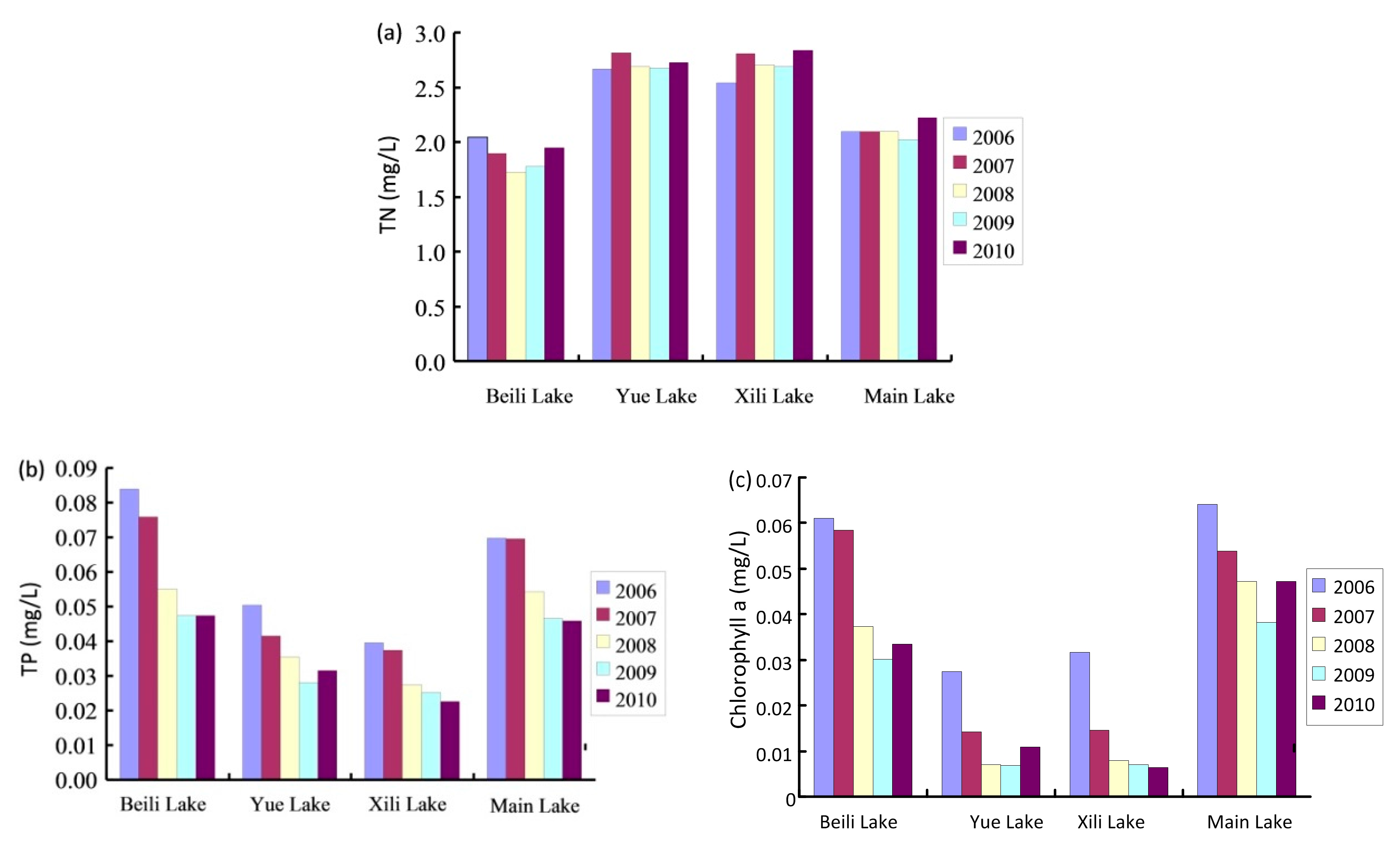
Figure 8 shows the annual average (2006–2010) TN, TP, and chlorophyll a concentrations in different regions of Xihu Lake before the implementation of the project. As shown in Figure 8a, the TN concentration in all those regions changed lightly from 2006 to 2010. In Beili Lake, the TN concentration was always lower compared to those in Yue Lake and Xili Lake. Although the TP and chlorophyll a concentrations in Beili Lake decreased during the water transfers, especially from 2006 to 2008, this decline has nearly stopped since 2009. In 2010, the average TP concentration in Beili Lake was about 0.047 mg/L, which was still about 50% and 104% higher than that in Yue Lake and Xili Lake, respectively. Moreover, associated with the poor water mobility in Beili Lake, the chlorophyll a concentration (0.33 mg/L) in Beili Lake was about three times and five times higher than that in Yue Lake and Xili Lake, respectively. Thus, the TP and chlorophyll a concentrations in Beili Lake have the potential to be reduced through rationally redistributing the water in the system.
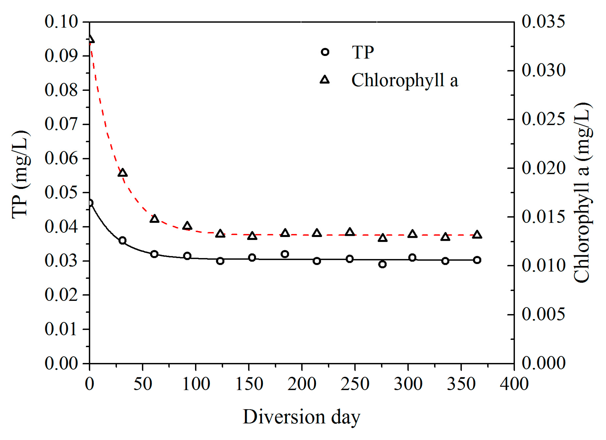
After the implementation of the project, the TP and chlorophyll a concentrations in Beili Lake dramatically decreased. With the dilution by the clean water diverted from Xili Lake, the TP concentration in Beili Lake was reduced by 32% after two months of diversion and 55% after four months of diversion. Meanwhile, the chlorophyll a concentration in Beili Lake decreased by 55% after two months of diversion and 61% after four months of diversion. In addition, as shown in Figure 9, the monthly continuous monitoring data provided by the Hangzhou Municipal Xihu Lake Administration Office clearly shows that the concentrations of TP, and chlorophyll a in Beili Lake had a downward trend after the diversion. In the first month after the implementation of the project, the concentrations of TP and chlorophyll a rapidly decreased. On average, the TP concentration decreased about 0.00038 mg/L per day and the chlorophyll a concentration decreased about 0.00044 mg/L per day. In the second month, the rate of descent of the TP and chlorophyll a concentrations decreased to 0.00011 mg/L per day and 0.00029 mg/L per day, respectively. The rate of descent gradually decreased with time as the concentrations of TP and chlorophyll a in Beili Lake got closer to those in Xili Lake, which is the water source of the diversion. After four months of diversion, the TP and chlorophyll a concentrations tended to stabilize, reaching 0.03 mg/L and 0.013 mg/L, respectively. The water quality has greatly improved (Class V, almost Class III).
4. Conclusions
In this study, the water diversion and distribution project in Beili Lake, a part of Xihu Lake, was introduced, and the flow field and turbidity of Beili Lake before and after the implementation of the water diversion and distribution project were investigated.
The concentration of the pollutants is highly related to the diffusion and advection of flow. Thus, to remove local pollutants, dead water zones in the lakes have to be eliminated. The Beili Lake water quality improvement project demonstrates that water diversion and proper distribution from Xili Lake, which has better water quality, can effectively replace the turbid water and increase the water transparency. For this small-scale diversion, the project was composed of an inlet with a debris screen, a submersible pump, pipelines, and four water distribution outlets with specified flow direction. With the implementation of this project, the flow velocity in Beili Lake significantly increased as the average velocity over the dead water zones increased approximately 50 times over that of prior to the project. The water exchange rate was increased as the average water exchange period reduced from 68 days to 22.5 days. The diversion and distribution has reconstructed an ideal flow field, which is conducive to improving the water quality of Beili Lake. The water transparency has increased and the water turbidity has decreased visibly and continues to decline. Moreover, the TP and chlorophyll a concentrations have obviously decreased after four months of diversion. The water quality in Beili Lake has greatly improved. The results offer useful information for understanding the efficiency of water diversion and distribution in improving the water quality of shallow lakes, and thus can give guidance to practical engineering for such systems.
Acknowledgments
This work was financially supported by the Major Science and Technology Program for Water Pollution Control and Treatment (2017ZX07206-03) and Major Science and Technology Program for Water Pollution Control and Treatment (2012ZX07101007) from Chinese Government. The authors thank the editor and reviewers for their valuable suggestions. We also appreciate the help of Zhiying Wu and Lin Chen in Hangzhou Municipal Xihu Lake Administration Office regarding the completion of this project.
Author Contributions
M.Z. performed most analysis and writing; A.D. helped with writing and drawing conclusions; W.Z. was instrumental on data collection; G.Y. supervised this study, led the data collection and revised the paper. All authors contributed substantially to revisions.
Conflicts of Interest
The authors declare no conflict of interest. The funding sponsors had no role in the design of the study; in the collection, analyses, or interpretation of data; in the writing of the manuscript, and in the decision to publish the results.
References
- Smith, V.H.; Schindler, D.W. Eutrophication science: Where do we go from here? Trends Ecol. Evol. 2009, 24, 201–207. [Google Scholar] [CrossRef] [PubMed]
- Qin, B.; Zhu, G.; Gao, G.; Zhang, Y.; Wei, L.; Paerl, H.W.; Carmichael, W.W. A drinking water crisis in Lake Taihu, China: Linkage to climatic variability and lake management. Environ. Manag. 2010, 45, 105–112. [Google Scholar] [CrossRef] [PubMed]
- Beklioğlu, M.; Bucak, T.; Coppens, J.; Bezirci, G.; Tavşanoğlu, Ü.N.; Çakıroğlu, A.İ.; Levi, E.E.; Erdoğan, Ş.; Filiz, N.; Özkan, K.; et al. Restoration of eutrophic lakes with fluctuating water levels: A 20-Year monitoring study of two Inter-Connected lakes. Water 2017, 9, 127. [Google Scholar] [CrossRef]
- Welch, E.B.; Cooke, G.D. Internal phosphorus loading in shallow lakes: Importance and control. Lake Reserv. Manag. 2005, 11, 273–281. [Google Scholar] [CrossRef]
- Norris, B.; Laws, E.A. Nutrients and phytoplankton in a shallow, hypereutrophic urban ake: Prospects for restoration. Water 2017, 9, 431. [Google Scholar] [CrossRef]
- Donabaum, K.; Schagerl, M.; Dokulil, M.T. Integrated management to restore macrophyte domination. Hydrobiologia 1999, 395/396, 87–97. [Google Scholar] [CrossRef]
- Mitsch, W.J.; Gosselink, J.G. Wetlands, 4th ed.; John Wiley & Sons, Inc.: New York, NY, USA, 2007; 582p, ISBN 978-0-471-69967-5. [Google Scholar]
- Mander, U.; Mitsch, W.J. Pollution control by wetlands. Ecol. Eng. 2009, 35, 153–158. [Google Scholar] [CrossRef]
- Sierp, M.T.; Qin, J.G.; Recknagel, F. Biomanipulation: A review of biological control measures in eutrophic waters and the potential for murray cod Maccullochella peelii peelii, to promote water quality in temperate Australia. Rev. Fish Biol. Fish. 2009, 19, 143–165. [Google Scholar] [CrossRef]
- Ying, A.; Bi, Y.; Hu, Z. Response of predominant phytoplankton species to anthropogenic impacts in Lake Taihu. J. Freshw. Ecol. 2015, 30, 99–112. [Google Scholar] [CrossRef]
- Jeppesen, E.; Søndergaard, M.; Meerhoff, M.; Lauridsen, T.L.; Jensen, J.P. Shallow lake restoration by nutrient loading reduction—Some recent findings and challenges ahead. Hydrobiologia 2007, 584, 239–252. [Google Scholar] [CrossRef]
- Winks, A.; Tian, K.; Liu, Y. Water Eutrophication Prevention by Phoslock Flocculation and Sediment Capping Reaction. In Proceedings of the International Conference on Environmental Science and Information Application Technology, Wuhan, China, 4–5 July 2009; Volume 1, pp. 349–352. [Google Scholar]
- Reitzel, K.; Lotter, S.; Dubke, M.; Egemose, S.; Jensen, H.S.; Andersen, F.Ø. Effects of phoslock®, treatment and chironomids on the exchange of nutrients between sediment and water. Hydrobiologia 2013, 703, 189–202. [Google Scholar] [CrossRef]
- Oglesby, R.T. Effects of controlled nutrient dilution on the eutrophication of a lake. In Eutrophication: Causes, Consequences, Correctives; Proceedings of a Symposium; National Academy of Sciences: Washington, DC, USA, 1969. [Google Scholar]
- Hosper, H.; Meyer, M.L. Control of phosphorus loading and flushing as restoration methods for Lake Veluwe, The Netherlands. Aquat. Ecol. 1986, 20, 183–194. [Google Scholar] [CrossRef]
- Vanderdoes, J.; Verstraelen, P.; Boers, P.; Vanroestel, J.; Roijackers, R.; Moser, G. Lake restoration with and without dredging of phosphorus-enriched upper sediment layers. Hydrobiologia 1992, 233, 197–210. [Google Scholar] [CrossRef]
- Moss, B.; Stansfield, J.; Irvine, K.; Perrow, M.; Phillips, G. Progressive restoration of a shallow lake: A 12-year experiment in isolation, sediment removal and biomanipulation. J. Appl. Ecol. 1996, 33, 71–86. [Google Scholar] [CrossRef]
- Hu, W.; Zhai, S.; Zhu, Z.; Han, H. Impacts of the Yangtze River water transfer on the restoration of Lake Taihu. Ecol. Eng. 2008, 34, 30–49. [Google Scholar] [CrossRef]
- James, R.T.; Pollman, C.D. Sediment and nutrient management solutions to improve the water quality of Lake Okeechobee. Lake Reserv. Manag. 2011, 27, 28–40. [Google Scholar] [CrossRef]
- Wu, J.; Wang, R.; Yu, J.Y.; Yu, Z.M.; Shen, X.D. Macrozoobenthos communities of West Lake after drawing fresh water from Qiantang River. Environ. Pollut. Control 1999, 21, 25–29. (In Chinese) [Google Scholar] [CrossRef]
- Gao, X.; Xu, L.; Zhang, C. Modelling the effect of water diversion projects on renewal capacity in an urban artificial lake in China. J. Hydroinform. 2015, 17, 990–1002. [Google Scholar] [CrossRef]
- Welch, E.B.; Barbiero, R.P.; Bouchard, D.; Jones, C.A. Lake trophic state change and constant algal composition following dilution and diversion. Ecol. Eng. 1992, 1, 173–197. [Google Scholar] [CrossRef]
- Hu, L.; Hu, W.; Zhai, S. Effects on water quality following water transfer in Lake Taihu, China. Ecol. Eng. 2010, 36, 471–481. [Google Scholar] [CrossRef]
- Welch, E.B.; Patmont, C.R. Lake restoration by dilution: Moses Lake, Washington. Water Res. 1980, 14, 1317–1325. [Google Scholar] [CrossRef]
- Welch, E.B. Phosphorus reduction by dilution and shift in fish species in Moses Lake, WA. Lake Reserv. Manag. 2009, 25, 276–283. [Google Scholar] [CrossRef]
- Lane, R.R.; Day, J.W., Jr.; Kemp, G.P.; Demcheck, D.K. The 1994 experimental opening of the Bonnet Carre Spillway to divert Mississippi River water into Lake Pontchartrain, Louisiana. Ecol. Eng. 2001, 17, 411–422. [Google Scholar] [CrossRef]
- Mishra, D.R.; Mishra, S. Plume and bloom: Effect of the Mississippi River diversion on the water quality of Lake Pontchartrain. Geocarto Int. 2010, 25, 555–568. [Google Scholar] [CrossRef]
- Jagtman, D.; Van der Molen, D.T.; Vermij, S. The influence of flushing on nutrient dynamics, composition and densities of algae and transparency in Veluwemeer, The Netherlands. Hydrobiologia 1992, 233, 187–196. [Google Scholar] [CrossRef]
- Das, D.K. Environmental Impact of Inter-Basin Water Transfer Projects: Some Evidence from Canada. Econ. Polit. Wkly. 2006, 41, 1703–1707. [Google Scholar]
- Miao, Z.L. Diversion works of channelling water into the lakes in Guilin. J. Guilin Inst. Technol. 2000, 20, 371–374. (In Chinese) [Google Scholar] [CrossRef]
- Hua, Z.L.; Gu, L.; Xue, H.; Liu, X.D. Assessing indicators for water diversion based on improving water quality of shallow lakes. J. Lake Sci. 2008, 5, 623–629. (In Chinese) [Google Scholar] [CrossRef]
- Jia, S.; You, Y.; Wang, R. Influence of water diversion from Yangtze River to Taihu Lake on nitrogen and phosphorus concentrations in different water areas. Water Resour. Prot. 2008, 24, 53–56. (In Chinese) [Google Scholar] [CrossRef]
- Zheng, J.Z.; Wang, L.; You, Z.Y.; Jiang, R.D. Influence of water diversion and drainage on lake current of Wuxi Watershed in Taihu Lake Basin. Autom. Water Resour. Hydrol. 2009, 4, 47–50. (In Chinese) [Google Scholar] [CrossRef]
- Zeng, H.; Wu, J. Tracing the Nitrate Sources of the Yili River in the Taihu Lake Watershed: A Dual Isotope Approach. Water 2015, 7, 188–201. [Google Scholar] [CrossRef]
- Li, Y.; Tang, C.; Wang, C.; Tian, W.; Pan, B.; Hua, L.; Lau, J.; Yu, Z.; Acharya, K. Assessing and modeling impacts of different inter-basin water transfer routes on Lake Taihu and the Yangtze River, China. Ecol. Eng. 2013, 60, 399–413. [Google Scholar] [CrossRef]
- Huang, J.; Gao, J.; Zhang, Y.; Xu, Y. Modeling impacts of water transfers on alleviation of phytoplankton aggregation in Lake Taihu. J. Hydroinform. 2015, 119, 329–337. [Google Scholar] [CrossRef]
- Li, Y.; Tang, C.; Wang, C.; Anim, D.O.; Yu, Z.; Acharya, K. Improved Yangtze River Diversions: Are they helping to solve algal bloom problems in Lake Taihu, China? Ecol. Eng. 2013, 51, 104–116. [Google Scholar] [CrossRef]
- Zhai, S.; Hu, W.; Zhu, Z. Ecological impacts of water transfers on Lake Taihu from the Yangtze River, China. Ecol. Eng. 2010, 36, 406–420. [Google Scholar] [CrossRef]
- Li, Y.P.; Acharya, K.; Chen, D.; Stone, M. Modeling water ages and thermal structure of Lake Mead under changing water levels. Lake Reserv. Manag. 2010, 26, 258–272. [Google Scholar] [CrossRef]
- Yu, J.J. Effects of water transfer on water quality improvement in Xihu Lake, a review. Water Resour. Prot. 1998, 2, 50–55. (In Chinese) [Google Scholar]
- General Bureau of China National Environmental Protection. National Environmental Protection Standard (GHZB 1-1999): Environmental Quality Standard for Surface Water; General Bureau of China National Environmental Protection: Beijing, China, 2000.
- Lambert, S.J.; Davy, A.J. Water quality as a threat to aquatic plants: Discriminating between the effects of nitrate, phosphate, boron and heavy metals on charophytes. New Phytol. 2011, 189, 1051–1059. [Google Scholar] [CrossRef] [PubMed]
- Luo, Z. Prediction of sedimentation for the navigation channel of a tidal inlet with mouth bar. IRTCES. In Proceedings of the 4th International Symposium on River Sedimentation, Beijing, China, 5–9 June 1989; China Ocean Press: Beijing, China, 1989; pp. 5–9. [Google Scholar]
- Luo, Z. Sediment transportation under wind, wave and tidal current. Hydro-Sci. Eng. 2004, 3, 1–6. (In Chinese) [Google Scholar] [CrossRef]
- Ministry of Communications of PRC. Technological Specification of Harbour Engineering (JTJ221-87); China Communications Press: Beijing, China, 1988. (In Chinese) [Google Scholar]
- Yan, K. Coastal Engineering; China Ocean Press: Beijing, China, 2002; ISBN 9787502754730. (In Chinese) [Google Scholar]
- Teng, X.; Wu, X.; Dong, J. A method of calculating wind wave elements. J. Oceanogr. Huanghai Bohai Seas 1985, 3, 5–17. (In Chinese) [Google Scholar]
- Cao, W.; Li, J.; Li, K.; Peng, Y. The measurement of sediment concentration using the turbidity measuring method and its applications. In Proceedings of the 8th National Symposium on Environmental and Ecological Hydraulics, Anshun, China, 1 September 2008; China Water & Power Press: Beijing, China, 2008; pp. 103–108. (In Chinese). [Google Scholar]
Figure 1.
Shoreline features of Xihu Lake.
Figure 2.
Aquatic plants artificially planted in a shallow lake in China.
Figure 3.
Locations of the field observations.
Figure 4.
Layout of diversion and water distribution for Beili Lake.
Figure 5.
Inlet of the pump station.
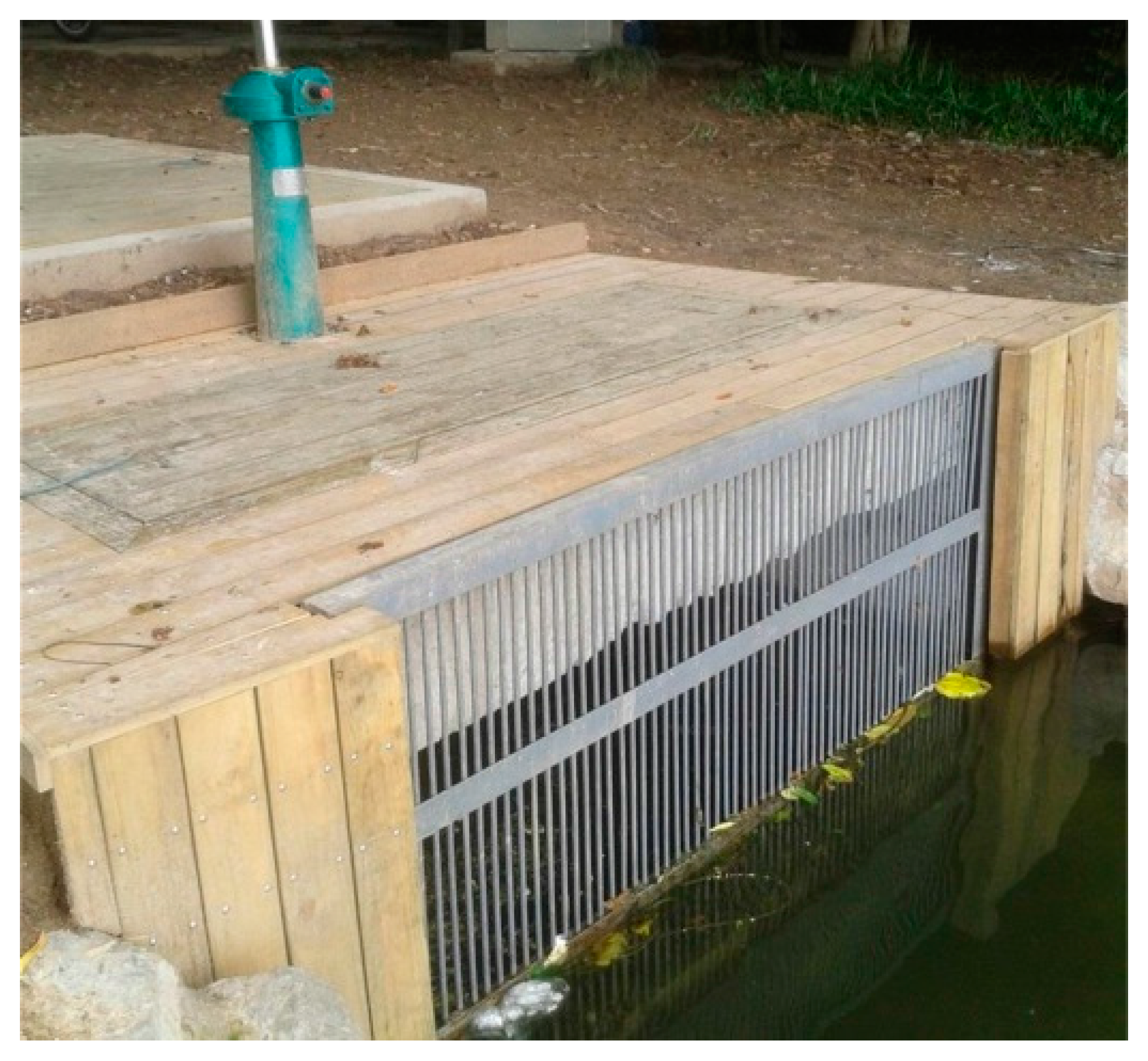
Figure 6.
Flow field of Beili Lake prior to the water diversion and distribution project (20 September 2010, provided by the Hangzhou Municipal Xihu Lake Administration Office).
Figure 6.
Flow field of Beili Lake prior to the water diversion and distribution project (20 September 2010, provided by the Hangzhou Municipal Xihu Lake Administration Office).
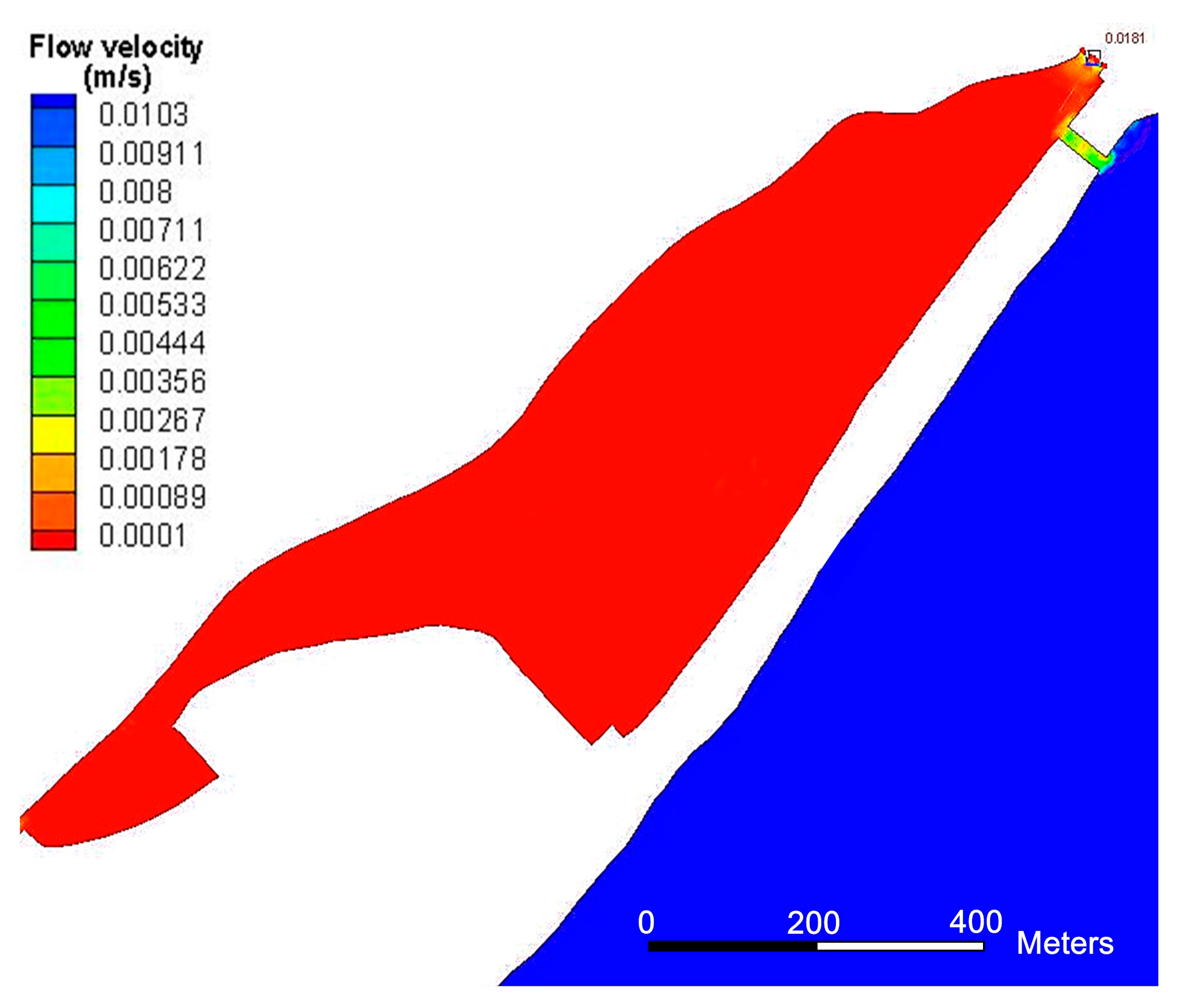
Figure 7.
Flow field of Beili Lake after the water diversion and distribution project (10 September 2012).
Figure 7.
Flow field of Beili Lake after the water diversion and distribution project (10 September 2012).
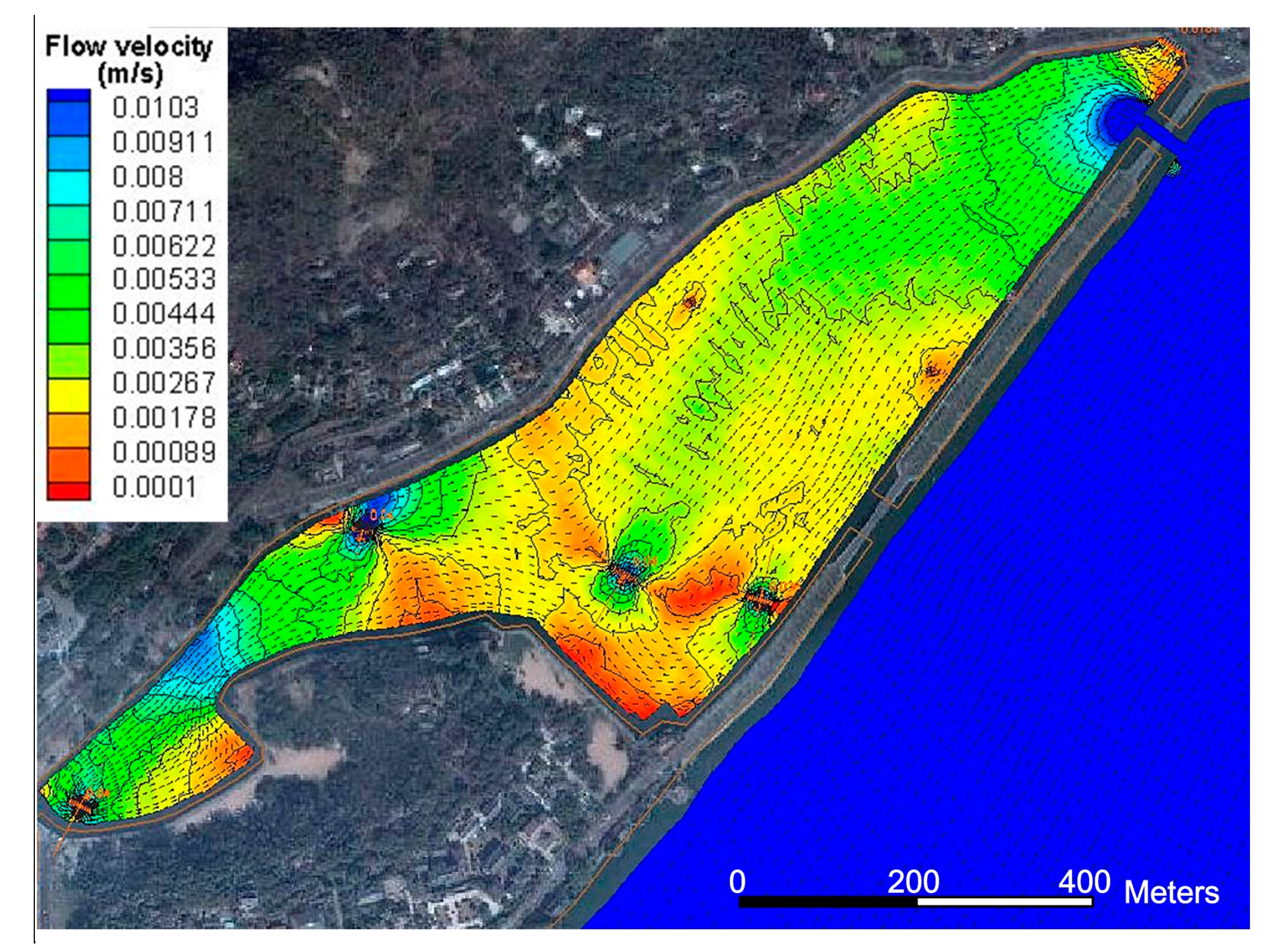
Figure 8.
(a) Total nitrogen (TN), (b) Total phosphorus (TP), and (c) chlorophyll concentrations in the lakes from 2006 to 2010.
Figure 8.
(a) Total nitrogen (TN), (b) Total phosphorus (TP), and (c) chlorophyll concentrations in the lakes from 2006 to 2010.

Figure 9.
Downward trend of TP and chlorophyll a in Beili Lake after the diversion.


Table 1.
Discharge at the five inlets and nine outlets.
| Outlets | Inlets | ||
|---|---|---|---|
| Name | Discharge (m3/s) | Name | Discharge (m3/s) |
| Beili Lake | 0.2496 | Xiaonan Lake | 2.351 |
| Yue Lake | 0.9632 | Huangmi House | 0.22 |
| Liulang | 0.0228 | Wugui Pool | 0.285 |
| Jinniuchi | 0.0588 | Zuibai House | 0.571 |
| Yongjin Gate | 0.0604 | Changqiao Bay | 1.16 |
| Dahua | 0.0081 | ||
| Park I | 0.0859 | ||
| Park V | 0.2310 | ||
| Shengtang Gate | 3.1223 | ||
Table 2.
Standard values of specific items for lakes and reservoirs [41].
Table 2.
Standard values of specific items for lakes and reservoirs [41].
| Item No. | Classification Standard Value Items | Class I | Class II | Class III | Class IV | Class V |
|---|---|---|---|---|---|---|
| 1 | Total Phosphorus (mg/L) ≤ | 0.002 | 0.01 | 0.025 | 0.06 | 0.12 |
| 2 | Total nitrogen (mg/L) ≤ | 0.2 | 0.5 | 1.0 | 1.5 | 2.0 |
| 3 | Chlorophyll a (mg/L) ≤ | 0.001 | 0.004 | 0.01 | 0.03 | 0.065 |
| 4 | Transparency (m) ≥ | 15 | 4 | 2.5 | 1.5 | 0.5 |
Table 3.
Data for the two field observations.
| Date | Water Inlet | Beili Lake | ||||||
|---|---|---|---|---|---|---|---|---|
| Average Velocity (m/s) | Diversion Discharge (m3/s) | Average Turbidity (NTU) | Average Velocity (m/s) | Average Turbidity (NTU) | Maximum Turbidity (NTU) | Average TP (mg/L) | Average Chlorophyll a (mg/L) | |
| 22–23 July 2012 | 0.119 | 0.246 | 6.80 | 0.0051 | 13.3 | 20.1 | 0.032 | 0.015 |
| Standard deviation | 0.009 | 1.26 | 0.0028 | 2.22 | 0.0053 | 0.0025 | ||
| 10–11 September 2012 | 0.122 | 0.252 | 7.84 | 0.0053 | 12.8 | 16.1 | 0.030 | 0.013 |
| Standard deviation | 0.007 | 0.99 | 0.0025 | 1.41 | 0.0033 | 0.0014 | ||
Table 4.
Weather condition before and during the field observations.
| Date | Weather | Temperature | Wind Direction | Beaufort Scale |
|---|---|---|---|---|
| 19 July 2012 | cloudy and sunny | 27–32 °C | Eastern | 3–4 |
| 20 July 2012 | cloudy and sunny | 26–36 °C | null | 2–3 |
| 21 July 2012 | cloudy and sunny | 26–36 °C | null | 2–3 |
| 22 July 2012 (Obs.) | cloudy and sunny | 27–36 °C | East-South | 3–4 |
| 23 July 2012 (Obs.) | sunny and cloudy | 27–34 °C | East-South | 3–4 |
| 7 September 2012 | shower to cloudy | 23–29 °C | East | 6–7 |
| 8 September 2012 | cloudy to shower | 24–31 °C | East-North | 5–6 |
| 9 September 2012 | moderate rain to shower | 23–28 °C | East-South | 4–5 |
| 10 September 2012 (Obs.) | cloudy | 22–26 °C | East-North | 3–4 |
| 11 September 2012 (Obs.) | cloudy | 23–30 °C | Eastern | 3–4 |
© 2018 by the authors. Licensee MDPI, Basel, Switzerland. This article is an open access article distributed under the terms and conditions of the Creative Commons Attribution (CC BY) license (http://creativecommons.org/licenses/by/4.0/).
Share and Cite
MDPI and ACS Style
Zhang, M.; Dolatshah, A.; Zhu, W.; Yu, G. Case Study on Water Quality Improvement in Xihu Lake through Diversion and Water Distribution. Water 2018, 10, 333. https://doi.org/10.3390/w10030333
AMA Style
Zhang M, Dolatshah A, Zhu W, Yu G. Case Study on Water Quality Improvement in Xihu Lake through Diversion and Water Distribution. Water. 2018; 10(3):333. https://doi.org/10.3390/w10030333
Chicago/Turabian StyleZhang, Minxi, Azam Dolatshah, Wenlong Zhu, and Guoliang Yu. 2018. "Case Study on Water Quality Improvement in Xihu Lake through Diversion and Water Distribution" Water 10, no. 3: 333. https://doi.org/10.3390/w10030333
Note that from the first issue of 2016, this journal uses article numbers instead of page numbers. See further details here.