Mountaintop Removal Mining and Catchment Hydrology

Abstract
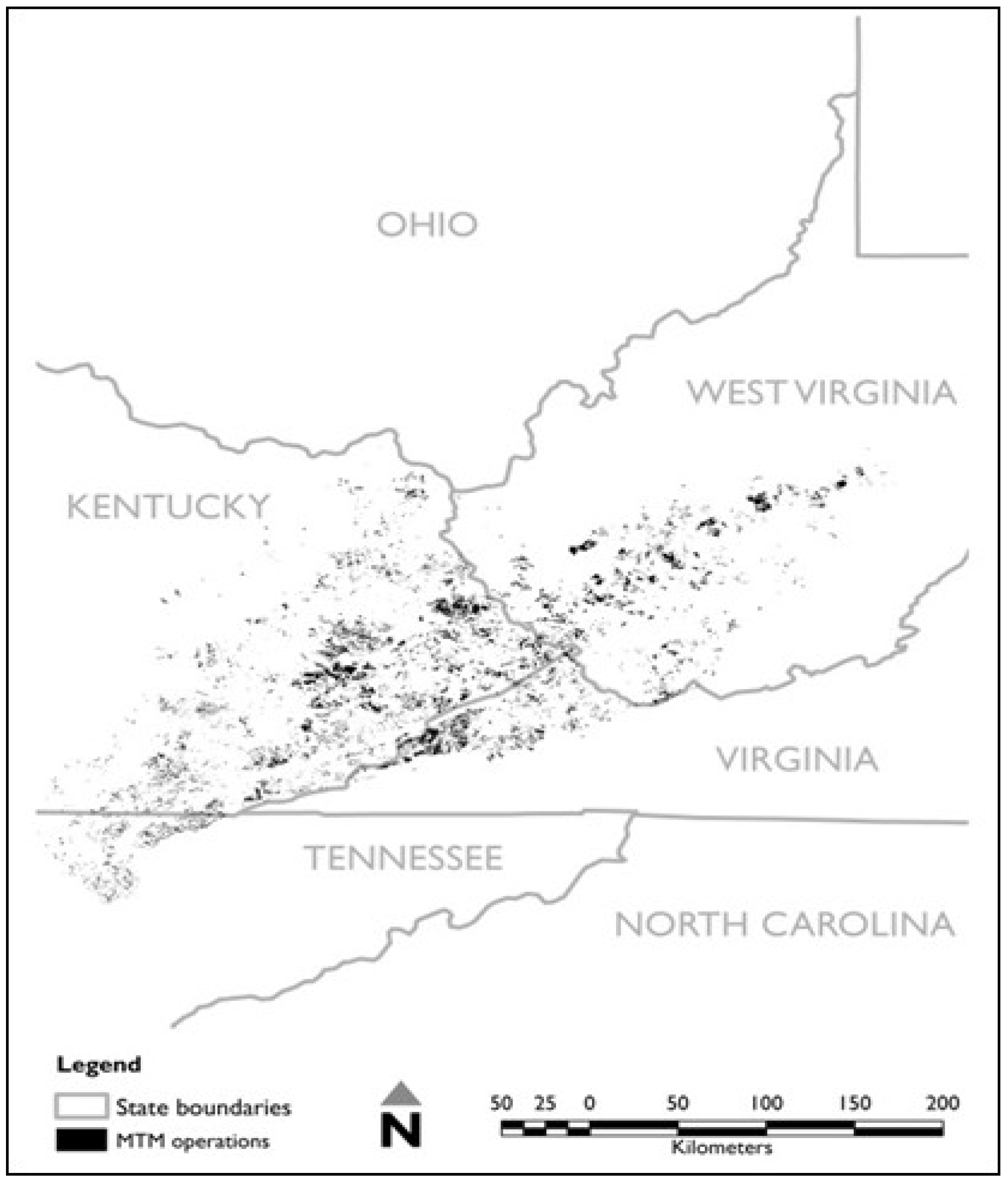
:1. Introduction

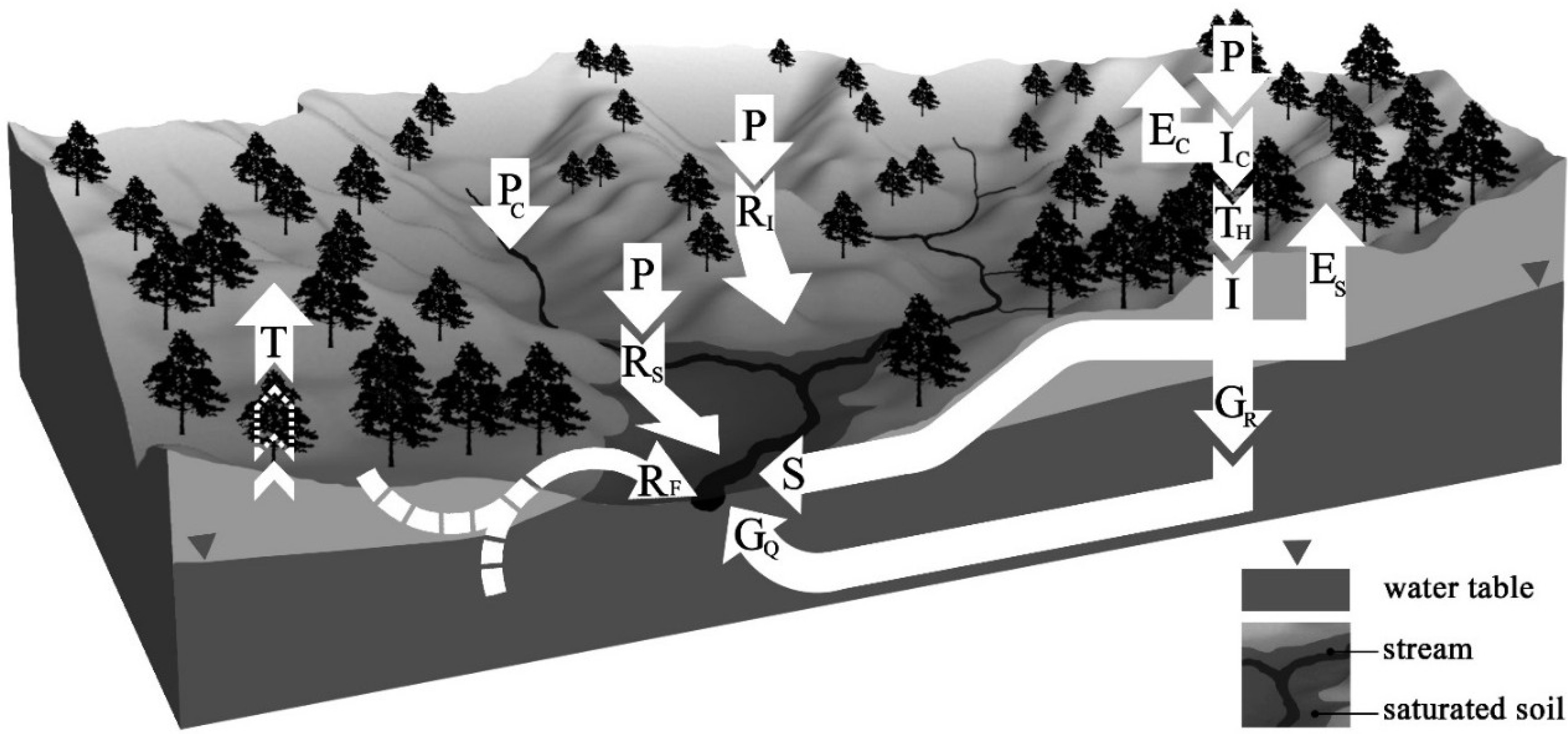
2. Overview of Catchment Hydrology
2.1. Water Balance and Catchment Processes

2.2. Landuse and Land Cover Changes
3. Impacts of Mountaintop-Removal Mining and Valley Fill on Hydrology
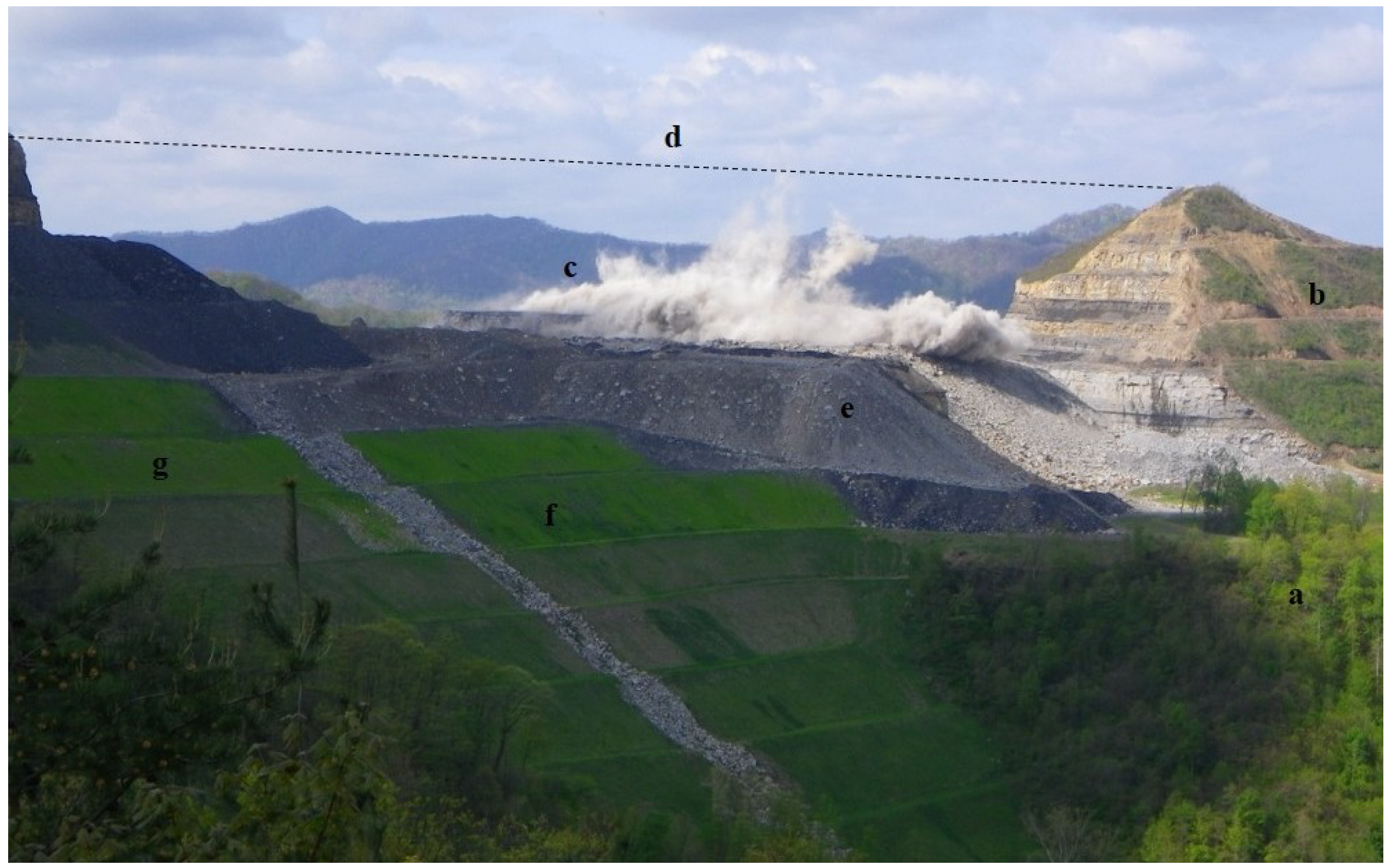
3.1. Overview of MTM/VF Operations


| Reference a | Year b | Location | Mining Method | # of catchments | Spatial Scale c | Time scale/ study duration | Key hydrologic observations |
|---|---|---|---|---|---|---|---|
| [47] | 1965 | Indiana | pre-SMCRA surface mining | 2 | HW to MS: 55.4 & 111.4 km2 | 3 months | Show that spoil piles act as reservoirs for groundwater storage. |
| [48] | 1966 | Indiana | pre-SMCRA surface mining | 2 | HW: 55 & 111 km2 | 12 months | Surface mine impacted watersheds maintained flows while forested catchments went dry during extreme draught conditions. |
| [49] | 1970 | Kentucky | pre-SMCRA strip mining | 3 | HW: 0.67–2.2 km2 | 4 years | Greater flow variability, less storage, larger peakflows in mined catchments. |
| [50,51] | 1972 | Kentucky | pre-SMCRA strip mining | 4 | HW: 0.66–1.8 km2 | Single storm event | During a major storm event, surface mined watersheds had smaller peak discharges than adjacent, undisturbed catchments. |
| [52] | 1972 | Kentucky | pre-SMCRA surface and underground mining | 1 | BA: 2442 km2 | 25 years | Streamflow is maintained during extended dry periods in mined catchments after streams in unmined catchments have ceased flowing, which the authors attributed to storage of water in underground mines, spoil piles, and strip pits. |
| [53] | 1981 | Kentucky | pre-SMCRA strip mining | 6 | HW: 0.70–1.5 km2 | 4 years | Storm flow volumes were unchanged but peak flows increased by 36% in mined catchments. This effect was most prominent during smaller events; higher magnitude peaks were unaffected. |
| [54] | 1987 | Pennsylvania | post-SMCRA surface mining | - | PS: 78 Infiltration tests on 5 reclaimed surface mines | 30 minutes tests on reclaimed mines 1–4 years old | Infiltration rates on newly reclaimed mine soil were an order of magnitude lower than undisturbed soils. Infiltration rate recovered through time the extent of which appeared to be controlled by overburden lithology. |
| [9] | 1989 | Tennessee | pre- and post-SMCRA contour mining; small scale MTM operations | 5 | HW: 1.74–11.2 km2 | 8 years | Total flow increased in mine-impacted catchments, particularly during low flow conditions. Authors attributed this to decreased ET losses from deforestation and the storage and slow release of runoff from mine spoil. |
| [55] | 1989 | West Virginia | pre-SMCRA strip and underground mining | 5 | HW: 4.66–20.07 km2 | 3–5 years | Synoptic discharge measurements revealed the importance of underground mining in rerouting subsurface water. A rainfall-runoff model indicated increased ET losses and decreased runoff in surface mined catchments. |
| [56] | 1991 | West Virginia | pre- and post-SMCRA strip mining; underground mining | 4 | HW: 12.6–21.8 km2 | 3 years | Peak stream discharges from mined basins were smaller than those from unmined areas, and mined basins had lower high flows and higher low flows than the unmined basins. |
| [57] | 1993 | Pennsylvania | post-SMCRA surface mining | 3 | HW: 0.11 & 0.32 km2 | 3 & 11 years in each catchment | The extent of infiltration rate recovery of reclaimed surface mines will control the storm hydrograph and drainage network evolution. Where recovery occurs, saturation excess overland flow becomes primary runoff mechanism. |
| [58] | 1995 | West Virginia | Unclear | - | PS: 8 ha spoil pile | 14 years | The spoil pile contained highly permeable spoil channels that are variably oriented and interconnected which created a pseudo-karst hydrologic setting. |
| [59] | 1997 | Ohio | post-SMCRA contour-area and haul-back mining | 3 | HW: ~0.12–0.2 km2 | 5–6 years | Mining and reclamation activities caused more frequent higher daily flow volumes. Peak flows on mined lands decreased with reclamation but were still greater than pre-mining flows. |
| [12,60,61] | 1999 | Kentucky | VF | 1 | HW: 4.1 km2 mine spoil area with 2 VFs | multiple scales/4 years | Identified 3 distinct but interconnected zones of water stored in mine spoil: slow moving water in the spoil interior and more rapidly moving water in the valley fills at lower elevations. |
| [62] | 2001 | Pennsylvania | post-SMCRA surface mining | 1 | HW: 0.32 km2 | 4 years | In spite of an increase in infiltration rate, little change is observed in total runoff from a reclaimed surface mine indicating contributions through throughflow and return flow. Dye tracing revealed a developed macropore network. |
| [63] | 2002 | West Virginia | MTM (VFs not considered in model) | 3 | HW: 9.9–26.1 km2 | 3 modeled storm events | Peak runoff increased 3%–21% in surface mined and timbered catchments based on hydrologic modeling. This significance of this additional input was lessened downstream. |
| [11] | 2003 | West Virginia | MTM/VF | 3 | Headwater: 0.49–5.67 km2 | storm event/2 years | During larger storm events, the mined catchment produced more unit runoff than the forested catchment. Double peaks were observed in the heavily mined catchment during intense storms. |
| [14] | 2003 | West Virginia | MTM/VF | 3 | 3 catchments: 0.49–5.67 km2 | daily & monthly/2 years | Total unit flow in mined catchment was approximately 2× greater than forested catchment, with greatest differences occurring dry periods. Unit flow during high flows was similar between the mined and forested catchment. |
| [16] | 2003 | West Virginia | MTM/VF | 5 | HW: 0.49–3.03 km2 | single storm event | Return interval in forested catchment varied from 10–25 years compared to <2 to >100 years in mined catchments. |
| [64] | 2004 | Kentucky | MTM/VF | 4 | HW: 1.4–6.5 km2 (theoretical catchments) | 2 storms; summer 2001 | Highly variable model outcomes, with surface mining either increasing or decreasing flood potential. However, the author concludes that, on balance, MTM/VF is likely to increase flood potential. |
| [65] | 2006 | Maryland | post-SMCRA strip mining | 2 | Headwater: 0.03 & 2.7 km2 | event-annual/3 years | Mined/reclaimed catchment show 2.5× higher storm runoff coefficients, 3× greater total runoff volume, and 2× higher peak hourly runoff rates than the forested catchment. |
| [41] | 2009 | Maryland | pre- and post-SMCRA strip mining | 1 | MS: 187.5 km2 | 310-year periods: 1971–1981, 1982–1992, 1994–2004 | Estimations of flood response showed that the rate at which flood magnitude increases due to increased mining is linear, a response synonymous with urbanization rather than deforestation. |
| [66] | 2009 | Maryland | pre- and post-SMCRA strip mining | 2 | Meso-scale: 127.2 &187.5 km2 | multiple scales /57 years | Floods in the mined catchment showed higher peak runoff and shorter centroid lag than the forested catchment but less total stormflow volume due to water lost through underground mine workings. |
| [67] | 2009 | Kentucky | loose dumped mine spoil | - | PS: 6 test cells: ~ 1 acre | 12 storm events / 15 month study period | Loose-dumped spoil of varying composition generally produced low discharge volumes (12% of rainfall), small peak discharge rates (between 2.5 × 10⁻⁵ and 3.0 × 10⁻³ m3/s), and long discharge durations (6 days on average). |
| [68] | 2011 | Maryland | pre- and post-SMCRA strip mining | 4 | Headwater: 3.0–27.1 ha | 15–61 storm events /3–8 years | Calculated curve numbers (range: 68–92) for three mined watersheds were generally higher than estimates from engineering methods (range: 65–79). |
| [69] | 2013 | West Virginia | MTM/VF | 1 | BA: 1011 km2 | annual /16 years | Statistically significant mean annual streaflow change not detected |
| [70] | 2014 | West Virginia | pre-SMCRA surface mine to MTM/VF | 2 | HW to BA:6.4 & 1011 km2 | storm event to annual/41 years | Characterized streamflow changes over lifetime of MTM/VF practice (1969–2010). Significant changes in streamflow variability and baseflow at different spatial & temporal scales. |
3.2. Traditional Surface Mining
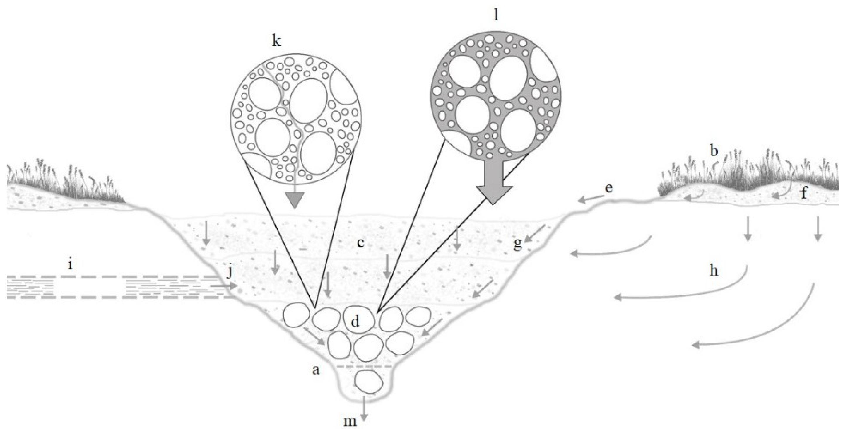
3.3. The Valley Fill
3.4. Mountaintop Mining and Valley Fill—A Two Part System
4. Knowledge Gaps and Future Research Directions
4.1. Streamflow Generation Processes in MTM-Impacted Catchments
4.2. Hydrology of Non-MTM Catchments in the Central Appalachian Coalfields
4.3. Valley Fill Hydrology
4.4. MTM/VF Reclamation Techniques
4.5. Thresholds
4.6. Multiple Spatial and Temporal Scales
4.7. Altered Topography
5. Concluding Remarks
Acknowledgments
Conflicts of Interest
References
- World Coal Association. Available online: http://www.worldcoal.org (accessed on 1 June 2013).
- Sayler, K.L. Land Cover Trends: Central Appalachians; US Geological Survey: Washington, DC, USA, 2008. [Google Scholar]
- US Environmental Protection Agency (EPA). The Effects of Mountaintop Mines and Valley Fills on Aquatic Ecosystems of the Central Appalachian Coalfields; US EPA: Washington, DC, USA, 2011; p. 153. [Google Scholar]
- US Energy Information Administration (EIA). Annual Energy Outlook 2013: Early Release Overview; DOE/EAI-0383ER(2013); U.S. Department of Energy: Washington, DC, USA, 2012; pp. 1–16. [Google Scholar]
- SkyTruth Mountaintop Removal Mining, Part 1: Measuring the Extent of Mountaintop Removal in Appalachia. Available online: http://blog.skytruth.org/2009/12/measuring-mountaintop-removal-mining-in.html (accessed on 5 March 2013).
- Griffith, M.B.; Norton, S.B.; Alexander, L.C.; Pollard, A.I.; LeDuc, S.D. The effects of mountaintop mines and valley fills on the physicochemical quality of stream ecosystems in the central Appalachians: A review. Sci. Total Environ. 2012, 417–418, 1–12. [Google Scholar] [CrossRef]
- Lindberg, T.T.; Bernhardt, E.S.; Bier, R.; Helton, A.M.; Merola, R.B.; Vengosh, A.; Di Giulio, R.T. Cumulative impacts of mountaintop mining on an Appalachian watershed. Proc. Natl. Acad. Sci. USA 2011, 108, 20929–20934. [Google Scholar]
- Bernhardt, E.S.; Lutz, B.D.; King, R.S.; Fay, J.P.; Carter, C.E.; Helton, A.M.; Campagna, D.; Amos, J. How Many Mountains Can We Mine? Assessing the regional degradation of central appalachian rivers by surface coal mining. Environ. Sci. Technol. 2012, 46, 8115–8122. [Google Scholar] [CrossRef]
- Dickens, P.S.; Minear, R.A.; Tschantz, B.A. Hydrologic alteration of mountain watersheds from surface mining. J. Water Pollut. Control Fed. 1989, 61, 1249–1260. [Google Scholar]
- Caruccio, F.T.; Geidel, G.; Williams, R. Induced Alkaline Recharge Zones to Mitigate Acidic Seeps. In Proceedings of the National Symposium on Surface Mining, Hydrology, Sedimentology and Reclamation, Lexington, KY, USA, 2 December 1984.
- Messinger, T. Comparison of Storm Response of Streams in Small, Unmined and Valley-Filled Watersheds, 1999–2001, Ballard Fork, West Virginia; US Geological Survey: Charleston, WV, USA, 2003; p. 22. [Google Scholar]
- Wunsch, D.R.; Dinger, J.S.; Graham, C.D.R. Predicting ground-water movement in large mine spoil areas in the Appalachian Plateau. Int. J. Coal Geol. 1999, 41, 73–106. [Google Scholar] [CrossRef]
- Green, J.; Passmore, M.; Childers, H. A Survey of the Condition of Streams in the Primary Region of Mountaintop Mining/Valley Fill Coal Mining; US Environmental Protection Agency: Philadelphia, PA, USA, 2000. [Google Scholar]
- Messinger, T.; Paybins, K.S. Relations between Precipitation and Daily and Monthly Mean Flows in Gaged, Unmined and Valley-Filled Watersheds, Ballard Fork, West Virginia, 1999–2001; WRi No.2003–4113; US Geological Survey: Charleston, WV, USA, 2003; p. 51. [Google Scholar]
- Wiley, J.B.; Evaldi, R.D.; Eychaner, J.H.; Chambers, D.B. Reconnaissance of Stream Geomorphology, Low Streamflow, and Stream Temperature in the Mountaintop Coal-Mining Region, Southern West Virginia, 1999–2000; US Geological Survey: Charleston, WV, USA, 2001; pp. 1–38. [Google Scholar]
- Wiley, J.B.; Brogan, F.D. Comparison of Peak Discharges Among Sites with and without Valley Fills for the July 8–9 2001, Flood in the Headwaters of Clear Fork, Coal River Basin, Mountaintop Coal-Mining Region, Southern West Virginia; U.S. Department of the Interior, U.S. Geological Survey: Charleston, WV, USA, 2003; pp. 1–16. [Google Scholar]
- Higginbotham, A.; Witt, T.S.; Childs, R.; Kent, C.; Pardue, E.; Risch, C. The West Virginia Coal Economy: 2008; Bureau of Business and Economic Research, West Virginia University and Center for Business and Economic Research, Marshall University: Huntington, WV, USA, 2008. [Google Scholar]
- Adams, M.B.; Edwards, P.J.; Ford, W.M.; Schuler, T.M.; Thomas-Van Gundy, M.; Wood, F. Fernow Experimental Forest: Research History and Opportunities; USDA Forest Service: Washington, DC, USA, 2012; p. 26. [Google Scholar]
- Carlyle-Moses, D.E.; Price, A.G. An evaluation of the Gash interception model in a northern hardwood stand. J. Hydrol. 1999, 214, 103–110. [Google Scholar] [CrossRef]
- Helvey, J.D.; Patric, J.H. Canopy and litter interception of rainfall by hardwoods of eastern United States. Water Resour. Res. 1965, 1, 193–206. [Google Scholar] [CrossRef]
- Price, K.; Jackson, C.R.; Parker, A.J. Variation of surficial soil hydraulic properties across land uses in the southern Blue Ridge Mountains, North Carolina, USA. J. Hydrol. 2010, 383, 256–268. [Google Scholar] [CrossRef]
- Moore, I.D.; Burch, G.J.; Wallbrink, P.J. Preferential flow and hydraulic conductivity of forest soils. Soil Sci. Soc. Am. J. 1985, 50, 876–881. [Google Scholar]
- Bonell, M. Progress in the understanding of runoff generation dynamics in forests. J. Hydrol. 1993, 150, 217–275. [Google Scholar] [CrossRef]
- Burns, D.A.; McDonnell, J.J.; Hooper, R.P.; Peters, N.E.; Freer, J.E.; Kendall, C.; Beven, K. Quantifying contributions to storm runoff through end-member mixing analysis and hydrologic measurements at the Panola Mountain Research Watershed (Georgia, USA). Hydrol. Process. 2001, 15, 1903–1924. [Google Scholar] [CrossRef]
- Hornberger, G.M.; Scanlon, T.M.; Raffensperger, J.P. Modelling transport of dissolved silica in a forested headwater catchment: The effect of hydrological and chemical time scales on hysteresis in the concentration-discharge relationship. Hydrol. Process. 2001, 15, 2029–2038. [Google Scholar] [CrossRef]
- Eshleman, K.N. Hydrological Consequences of Land Use Change: A Review of the State-of-Science. In Ecosystems and Land Use Change; AGU: Washington, DC, 2004; pp. 13–29. [Google Scholar]
- Hornbeck, J.W.; Pierce, R.S.; Federer, C.A. Streamflow changes after forest clearing in New England. Water Resour. Res. 1970, 6, 1124–1132. [Google Scholar] [CrossRef]
- Jones, J.A.; Grant, G.E. Peak flow responses to clear-cutting and roads in small and large basins, western Cascades, Oregon. Water Resour. Res. 1996, 32, 959–974. [Google Scholar] [CrossRef]
- Thomas, R.B.; Megahan, W.F. Peak flow responses to clear-cutting and roads in small and large basins, western Cascades, Oregon: A second opinion. Water Resour. Res. 1998, 34, 3393–3403. [Google Scholar] [CrossRef]
- Potter, K.W. Hydrological impacts of changing land management practices in a moderate-sized agricultural catchment. Water Resour. Res. 1991, 27, 845–855. [Google Scholar] [CrossRef]
- Gremillion, P.; Gonyeau, A.; Wanielista, M. Application of alternative hydrograph separation models to detect changes in flow paths in a watershed undergoing urban development. Hydrol. Process. 2000, 14, 1485–1501. [Google Scholar] [CrossRef]
- O’Driscoll, M.; Clinton, S.; Jefferson, A.; Manda, A.; McMillan, S. Urbanization effects on watershed hydrology and in-stream processes in the southern United States. Water 2012, 2. [Google Scholar] [CrossRef]
- Rose, S.; Peters, N.E. Effects of urbanization on streamflow in the Atlanta area (Georgia, USA): A comparative hydrological approach. Hydrol. Process. 2001, 15, 1441–1457. [Google Scholar] [CrossRef]
- Bosch, J.M.; Hewlett, J.D. A review of catchment experiments to determine the effect of vegetation changes on water yield and evapotranspiration. J. Hydrol. 1982, 55, 3–23. [Google Scholar] [CrossRef]
- Wemple, B.C.; Jones, J.A.; Grant, G.E. Channel network extension by logging roads in two basins, western Cascades, Oregon. J. Am. Water Resour. Assoc. 1996, 32, 1195–1207. [Google Scholar] [CrossRef]
- Jones, J.A.; Swanson, F.J.; Wemple, B.C.; Snyder, K.U. Effects of roads on hydrology, geomorphology, and disturbance patches in stream networks. Conserv. Biol. 2000, 14, 76–85. [Google Scholar] [CrossRef]
- Eisenbies, M.H.; Aust, W.M.; Burger, J.A.; Adams, M.B. Forest operations, extreme flooding events, and considerations for hydrologic modeling in the Appalachians—A review. For. Ecol. Manag. 2007, 242. [Google Scholar] [CrossRef]
- Sidle, R.C.; Ziegler, A.D.; Negishi, J.N.; Nik, A.R.; Siew, R.; Turkelboom, F. Erosion processes in steep terrain—Truths, myths, and uncertainties related to forest management in Southeast Asia. For. Ecol. Manag. 2006, 224, 199–225. [Google Scholar] [CrossRef]
- Skaggs, R.W.; Brevé, M.A.; Gilliam, J.W. Hydrologic and water quality impacts of agricultural drainage. Crit. Rev. Environ. Sci. Technol. 1994, 24, 1–32. [Google Scholar] [CrossRef]
- Dow, C.L.; DeWalle, D.R. Trends in evaporation and Bowen Ratio on urbanizing watersheds in eastern United States. Water Resour. Res. 2000, 36, 1835–1843. [Google Scholar] [CrossRef]
- Ferrari, J.R.; Lookingbill, T.R.; McCormick, B.; Townsend, P.A.; Eshleman, K.N. Surface mining and reclamation effects on flood response of watersheds in the central Appalachian Plateau region. Water Resour. Res. 2009, 45. [Google Scholar] [CrossRef]
- Peng, S.S. Mountaintop removal controversy slows West Virginia coal mining. Min. Eng. 2000, 52, 53–58. [Google Scholar]
- US Congress. Surface Mining Control and Reclamation Act. US Congress: Washington, DC, USA, 1977. [Google Scholar]
- Angel, P.; Graves, D.; Barton, C.; Warner, R.C.; Conrad, P.; Sweigard, R.C.; Agouridis, C. Surface mine reforestation research: Evaluation of tree response to low compaction reclamation techniques. In Proceedings of the 7th International Conference on Acid Rock Drainage (ICARD); American Society of Mining and Reclamation (ASMR): St. Louis, MO, USA, 2006; pp. 45–58. [Google Scholar]
- Graves, D.H.; Ringe, J.M.; Pelkki, M.H.; Sweigard, R.J.; Warner, R. High value tree reclamation research. In Environmental Issues and Management of Waste in Energy and Mineral Production; CRC Press: Boca Raton, FL, USA, 2000; pp. 413–421. [Google Scholar]
- Zipper, C.; Burger, J.; Skousen, J.; Angel, P.; Barton, C.; Davis, V.; Franklin, J. Restoring forests and associated ecosystem services on appalachian coal surface mines. Environ. Manag. 2011, 47, 751–765. [Google Scholar] [CrossRef]
- Traux, C.N. Water storage potential of surface coal mined lands. Min. Congr. J. 1965, 51, 40–46. [Google Scholar]
- Agnew, A.F. A quarter to zero—Surface mining and water supplies. Min. Congr. J. 1966, 52, 29, 32–34, 38–40. [Google Scholar]
- Collier, C.R.; Pickering, R.J.; Musser, J.J. Influences of Strip Mining on the Hydrologic Environment of Parts of the Beaver Creek Basin, Kentucky, 1955–66; US Geological Survey: Lexington, KY, USA, 1970. [Google Scholar]
- Curtis, W.R. Strip-mining increases flood potential of mountain watersheds. In National Symposium of Watersheds in Transition; American Water Resources Association: Fort Collins, CO, USA, 1972; pp. 357–360. [Google Scholar]
- Curtis, W.R. Surface Mining and the Flood of April 1977; US Forest Service Research Note NE-248: Berea, KY, USA, 1977; pp. 1–4. [Google Scholar]
- Grubb, H.F.; Ryder, P.O. Effect of Coal Mining on the Water Resources of the Tradewater River Basin, Kentucky; US Geological Survey: Lexington, KY, USA, 1972; pp. 1–91. [Google Scholar]
- Bryan, B.A.; Hewlett, J.D. Effect of surface mining on storm flow and peak flow from six small basins in eastern Kentucky. JAWRA J. Am. Water Resour. Assoc. 1981, 17, 290–299. [Google Scholar] [CrossRef]
- Jorgensen, D.W.; Gardner, T.W. Infiltration capacity of disturbed soils: Temporal changes and lithologic controls. JAWRA JAWRA J. Am. Water Resour. Assoc. 1987, 23, 1161–1172. [Google Scholar] [CrossRef]
- Puente, C.; Atkins, J.T. Simulation of Rainfall-Runoff Response in Mined and Unmined Watersheds in Coal Areas of West Virginia; US Geological Survey: Charleston, WV, USA, 1989; pp. 1–56. [Google Scholar]
- Borchers, J.W.; Ehlke, T.A.; Mathes, M.V.; Downs, S.C. The Effects of Coal Mining on the Hydrologic Environmnet of Selected Stream Basins in Southern West Virginia; U.S. Geological Survey: Charleston, WV, USA, 1991. [Google Scholar]
- Ritter, J.B.; Gardner, T.W. Hydrologic evolution of drainage basins disturbed by surface mining, central Pennsylvania. Geol. Soc. Am. Bull. 1993, 105, 101–115. [Google Scholar]
- Caruccio, F.T.; Geidel, G. Status Report: Long-Term Effects of Alkaline Trenches and Funnels at the Mercer Site; West Virginia Surface Mine Drainage Task Force Symposium: Morgantown, WV, USA, 4 April 1995. [Google Scholar]
- Bonta, J.V.; Amerman, C.R.; Harlukowicz, T.J.; Dick, W.A. Impact of surface coal mining on three Ohio watersheds—Surface water hydrology. JAWRA J. Am. Water Resour. Assoc. 1997, 33, 907–917. [Google Scholar] [CrossRef]
- Wunsch, D.; Dinger, J.; Taylor, P. Design, Construction, and Monitoring of the Ground-Water Resources of a Large Spoil Area: Star Fire Tract, Eastern Kentucky; Kentucky Geological Survey: Lexington, KY, USA, 1992; pp. 1–16. [Google Scholar]
- Wunsch, D.; Dinger, J.; Taylor, P.; Carey, D.; Graham, C. Hydrogeology, hydrogeochemistry, and spoil settlement at a large mine-spoil area in eastern Kentucky: Star Fire Tract; Kentucky Geological Survey: Lexington, KY, USA, 1996; pp. 1–55. [Google Scholar]
- Guebert, M.D.; Gardner, T.W. Macropore flow on a reclaimed surface mine: Infiltration and hillslope hydrology. Geomorphology 2001, 39, 151–169. [Google Scholar] [CrossRef]
- Flood Advisory Taskforce. Runoff Analyses of Seng, Scrabble, and Sycamore Creeks, Part 1; WV Department of Environmental Protection: Charlseton, WV, USA, 2002. [Google Scholar]
- Phillips, J.D. Impacts of surface mine valley fills on headwater floods in eastern Kentucky. Environ. Geol. 2004, 45, 367–380. [Google Scholar] [CrossRef]
- Negley, T.L.; Eshleman, K.N. Comparison of stormflow responses of surface-mined and forested watersheds in the Appalachian Mountains, USA. Hydrol. Process. 2006, 20, 3467–3483. [Google Scholar] [CrossRef]
- McCormick, B.C.; Eshleman, K.N.; Griffith, J.L.; Townsend, P.A. Detection of flooding responses at the river basin scale enhanced by land use change. Water Resour. Res. 2009, 45, W08401. [Google Scholar]
- Taylor, T.J.; Agouridis, C.T.; Warner, R.C.; Barton, C.D.; Angel, P.N. Hydrologic characteristics of Appalachian loose-dumped spoil in the Cumberland Plateau of eastern Kentucky. Hydrol. Process. 2009, 23, 3372–3381. [Google Scholar] [CrossRef]
- McCormick, B.C.; Eshleman, K.N. Assessing hydrologic change in surface-mined watersheds using the curve number method. J. Hydrol. Eng. 2011, 16, 575–584. [Google Scholar] [CrossRef]
- Zégre, N.P.; Maxwell, A.; Lamont, S. Characterizing streamflow response of a mountaintop-mined watershed to changing land use. Appl. Geogr. 2013, 39, 5–15. [Google Scholar] [CrossRef]
- Zégre, N.; Miller, A.J.; Maxwell, A.; Lamont, S. Multi-scale analysis of hydrology in a mountaintop mineimpacted watershed. J. Am. Water Resour. Assoc. in press.
- Rodrigue, J.A.; Burger, J.A. Forest productivity and woody species diversity on pre-SMCRA mined land. In National Meeting for the American Society of Mine Reclamation; American Society of Mine Reclamation: Tampa, FL, USA, 2000; pp. 205–225. [Google Scholar]
- Bussler, B.H.; Byrnes, W.R.; Pope, P.E.; Chaney, W.R. Properties of minesoil reclaimed for forest land use. Soil Sci. Soc. Am. J. 1984, 48, 178–184. [Google Scholar] [CrossRef]
- Holl, K.D. Long-term vegetation recovery on reclaimed coal surface mines in the eastern USA. J. Appl. Ecol. 2002, 39, 960–970. [Google Scholar] [CrossRef]
- Barnhisel, R.I.; Hower, J.M. Coal surface mine reclamation in the eastern United States: The revegetation of disturbed lands to hayland/pasture or cropland. In Advances in Agronomy; Academic Press: San Diego, CA, USA, 1997. [Google Scholar]
- Bradshaw, A.D. The reclamation of derelict land and the ecology of ecosystems. In Restoration Ecology: A Synthetic Approach to Ecological Research; Jordan, W.R., Gilpin, M.E., Aber, J.D., Eds.; Cambridge Unversity Press: Cambridge, UK, 1990; pp. 53–75. [Google Scholar]
- Kelliher, F.M.; Leuning, R.; Schulze, E.D. Evaporation and canopy characteristics of coniferous forests and grasslands. Oecologia 1993, 95, 153–163. [Google Scholar] [CrossRef]
- Webb, W.; Szarek, S.; Lauenroth, W.; Kinerson, R.; Milton, S. Primary productivity and water use in native forest, grassland, and desert ecosystems. Ecology 1978, 59, 1239–1247. [Google Scholar] [CrossRef]
- Bell, J.C.; Cunningham, R.L.; Anthony, C.T. Morphological characteristics of reconstructed prime farmland soils in western Pennsylvania. J. Environ. Qual. 1994, 23, 515–520. [Google Scholar]
- Indorante, S.J.; Jansen, I.J.; Boast, C.W. Surface mining and reclamation: Initial changes in soil character. J.Soil Water Conserv. 1981, 36, 347–351. [Google Scholar]
- Ciolkosz, E.J.; Cronce, R.C.; Cunningham, R.L.; Petersen, G.W. Characteristics, genesis, and classification of Pennsylvania minesoils. Soil Science 1985, 139, 232–238. [Google Scholar] [CrossRef]
- Chong, S.K.; Cowsert, P.T. Infiltration in reclaimed mined land ameliorated with deep tillage treatments. Soil Tillage Res. 1997, 44, 255–264. [Google Scholar] [CrossRef]
- Silburn, D.M.; Crow, F.R. Soil properties of surface mined land. Am. Soc. Agric. Eng. 1984, 27, 827–832. [Google Scholar]
- Power, J.F.; Ries, R.E.; Sandoval, F.M. Reclamation of coal-mined land in the northern great plains. J. Soil Water Conserv. 1978, 33, 69–74. [Google Scholar]
- Potter, K.; Carter, F.; Doll, E. Physical properties of constructed and undisturbed soils. Soil Sci. Soc. Am. J. 1988, 52, 1435–1438. [Google Scholar] [CrossRef]
- McSweeney, K.; Jansen, I.J. Soil structure and associatedrooting behavior in minesoils. Soil Sci. Soc. Am. J. 1984, 48, 607–612. [Google Scholar] [CrossRef]
- Pedersen, T.A.; Rogowski, A.S.; Pennock, R. Physical characteristics of some minesoils. Soil Sci. Soc. Am. J. 1980, 44, 321–328. [Google Scholar] [CrossRef]
- Bonta, J.V. Impact of coal surface mining and reclamation on suspended sediment in three Ohio watersheds. JAWRA J. Am. Water Resour. Assoc. 2000, 36, 869–887. [Google Scholar] [CrossRef]
- Fox, J.F. Identification of sediment sources in forested watersheds with surface coal mining disturbance using carbon and nitrogen isotopes. JAWRA J. Am. Water Resour. Assoc. 2009, 45, 1273–1289. [Google Scholar] [CrossRef]
- Lemieux, C.R. Infiltration Characteristics and Hydrologic Modeling of Disturbed Land, Moshannon, Pennsylvania. Master’s Thesis, Pennsylvania State University, University Park, PA, USA, 1987. [Google Scholar]
- Ritter, J.B. Surface Hydrology of Drainage Basins Disturbed by Surface Mining and Reclamation, Central Pennsylvania. Ph.D Thesis, Pennsylvania State University, University Park, PA, USA, 1990. [Google Scholar]
- Curtis, W.R. Surface mining and the hydrologic balance. Min. Congr. J. 1979, 7, 35–40. [Google Scholar]
- Sherman, L.K. Streamflow from rainfall by the unit-graph method. Eng. News Record 1932, 108, 501–505. [Google Scholar]
- US Environmental Protection Agency (EPA). Draft Programmatic Environmental Impact Statement —Mountaintop Mining/Valley Fills in Appalachia; US EPA-Region 3: Philadelphia, PA, USA, 2003. [Google Scholar]
- Michael, P.R.; Superfesky, M.J.; Uranowski., L.J. Challenges to Applying Geomorphic and Stream Reclamation Methodologies to Mountaintop Mining and Excess Spoil Fill Construction in Steep-Slope Topography (e.g. Central Appalachia). In Proceedings of the 2010 National Meeting of the American Society of Mining and Reclamation, Pittsburgh, PA, USA, 5–11 June 2010.
- Hawkins, J.W.; Dunn, M. Hydrologic characteristics of a 35-year-old underground mine pool. Mine Water Environ. 2007, 26, 150–159. [Google Scholar] [CrossRef]
- Hirsh, R.M.; Scott, A.G.; Wyant, T. Investiagation of trends in flooding in the Tug Fork basin of Kentucky, Virginia, and West Virginia; US Geological Survey: Alexandria, VA, USA, 1982; pp. 1–41. [Google Scholar]
- Larson, J.D.; Powell, J.D. Hydrology and Effects of Mining in the Upper Russell Fork Basin, Buchanan and Dickenson Counties, Virginia; US Geological Survey: Lexiongton, KY, USA, 1986; pp. 1–62. [Google Scholar]
- Bonta, J.V. Challenges in conducting hydrologic and water quality research in drastically disturbed watersheds. J. Soil Water Conserv. 2005, 60, 121–133. [Google Scholar]
- Meriano, M.; Howard, K.W.F.; Eyles, N. The role of midsummer urban aquifer recharge in stormflow generation using isotopic and chemical hydrograph separation techniques. J. Hydrol. 2011, 396, 82–93. [Google Scholar] [CrossRef]
- Zegre, N.; McGuire, K. Characterizing the Hydrologic Impacts of Mountaintop Mining Using Stable Isotopes. EOS Trans. Am. Geophys. Union, 2011; Fall Meeting 2011, abstract #H31A-1120. [Google Scholar]
- DeWalle, D.R.; Swistock, B.R.; Sharpe, W.E. Three-component tracer model for stormflow on a small Appalachian forested catchment. J. Hydrol. 1988, 104, 301–310. [Google Scholar] [CrossRef]
- Kipp, J.A.; Dinger, J.S. Stress-Relief Fracture Control of Ground-Water Movement in the Appalachian Plateaus, In Proceedings of the Fourth Annual Eastern Regional Ground Water Conference, Burlington, VT, USA, 14–16 July 1987; National Water Welll Association: Burlington, VT, 1987; pp. 423–438.
- Wyrick, G.G.; Borchers, J.W. Hydrologic Effects of Stress-Relief Fracturing an Appalachian Valley [West Virginia]; US Geological Survey: Washington, DC, USA, 1981; pp. 1–51. [Google Scholar]
- Merriam, E.R.; Petty, J.T.; Merovich, G.T.; Fulton, J.B.; Strager, M.P. Additive effects of mining and residential development on stream conditions in a central Appalachian watershed. J. North Am. Benthol. Soc. 2011, 30, 399–418. [Google Scholar] [CrossRef]
- Petty, J.T.; Fulton, J.B.; Strager, M.P.; Merovich, G.T.; Stiles, J.M.; Ziemkiewicz, P.F. Landscape indicators and thresholds of stream ecological impairment in an intensively mined Appalachian watershed. J. North Am. Benthol. Soc. 2010, 29, 1292–1309. [Google Scholar] [CrossRef]
- Burger, J.; Graves, D.; Angel, P.; Davis, V.; Zipper, C. The forestry reclamation approach; Appalachian Regional Reforestation Initiative. Forest Reclamation Advisory. 2005, 2. [Google Scholar]
- Rogowski, A.S.; Jacoby, E.L. Monitoring water movement through strip mine spoil profiles. Trans. ASAE 1979, 22, 104–109. [Google Scholar] [CrossRef]
- Ehlke, T.E.; Runner, G.S.; Downs, S.C. Hydrology of Area 9, Eastern Coal Province, West Virginia. US Geological Survey: Charleston, WV, USA, 1982. [Google Scholar]
- Stednick, J.D. Monitoring the effects of timber harvest on annual water yield. J. Hydrol. 1996, 176, 79–95. [Google Scholar] [CrossRef]
- McGlynn, B.L.; McDonnell, J.J.; Seibert, J.; Kendall, C. Scale effects on headwater catchment runoff timing, flow sources, and groundwater-streamflow relations. Water Resour. Res. 2004, 40, W07504. [Google Scholar]
- McGuire, K.J.; McDonnell, J.J. Hydrological connectivity of hillslopes and streams: Characteristic time scales and nonlinearities. Water Resour. Res. 2010, 46, W10543. [Google Scholar]
© 2014 by the authors; licensee MDPI, Basel, Switzerland. This article is an open access article distributed under the terms and conditions of the Creative Commons Attribution license (http://creativecommons.org/licenses/by/3.0/).
Share and Cite
Miller, A.J.; Zégre, N.P. Mountaintop Removal Mining and Catchment Hydrology. Water 2014, 6, 472-499. https://doi.org/10.3390/w6030472
Miller AJ, Zégre NP. Mountaintop Removal Mining and Catchment Hydrology. Water. 2014; 6(3):472-499. https://doi.org/10.3390/w6030472
Chicago/Turabian StyleMiller, Andrew J., and Nicolas P. Zégre. 2014. "Mountaintop Removal Mining and Catchment Hydrology" Water 6, no. 3: 472-499. https://doi.org/10.3390/w6030472