
Radon in Groundwater of the Northeastern Gran Canaria Aquifer

Abstract
:1. Introduction
2. Area of Study
2.1. General Description

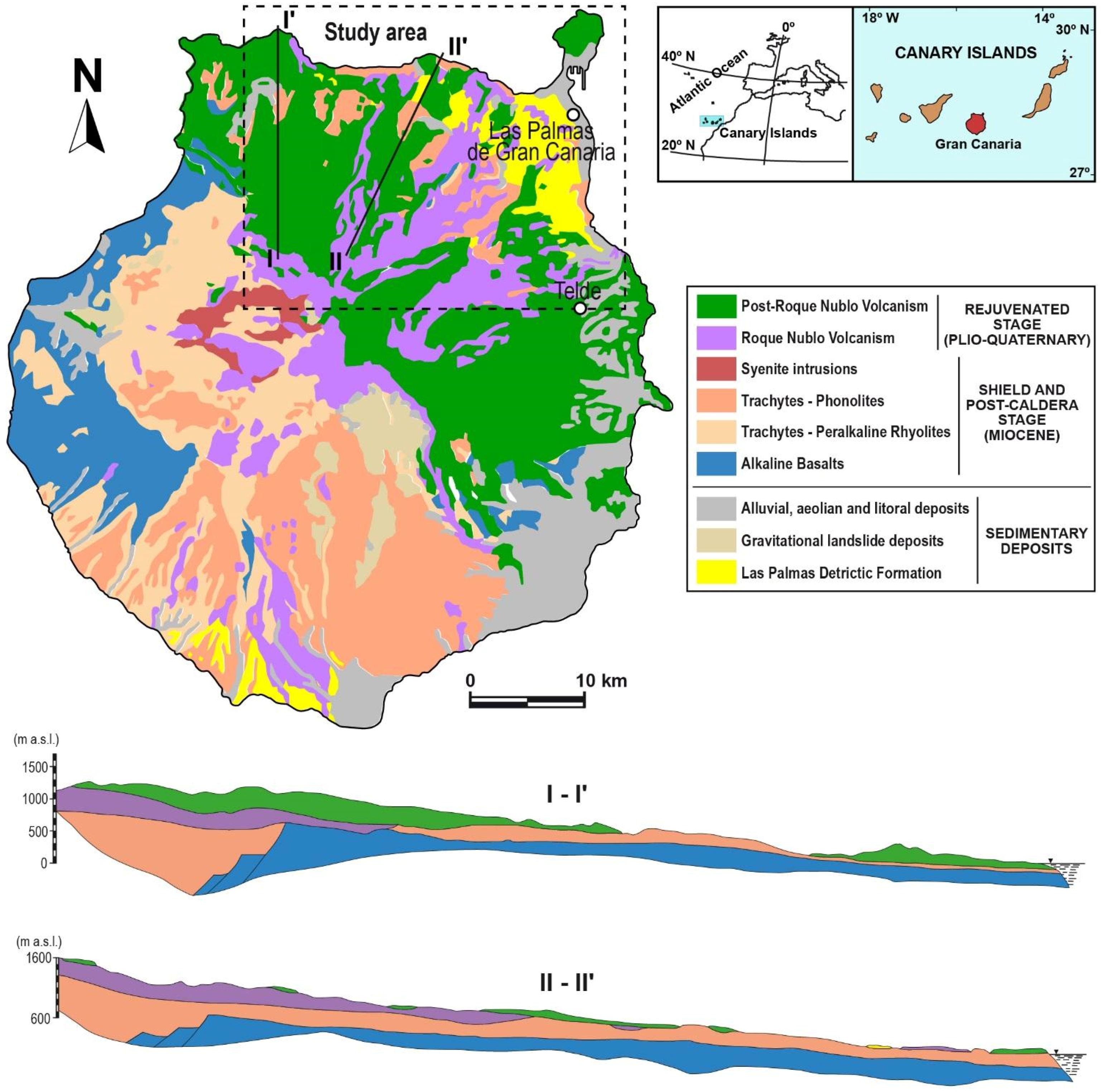
2.2. Geological Setting
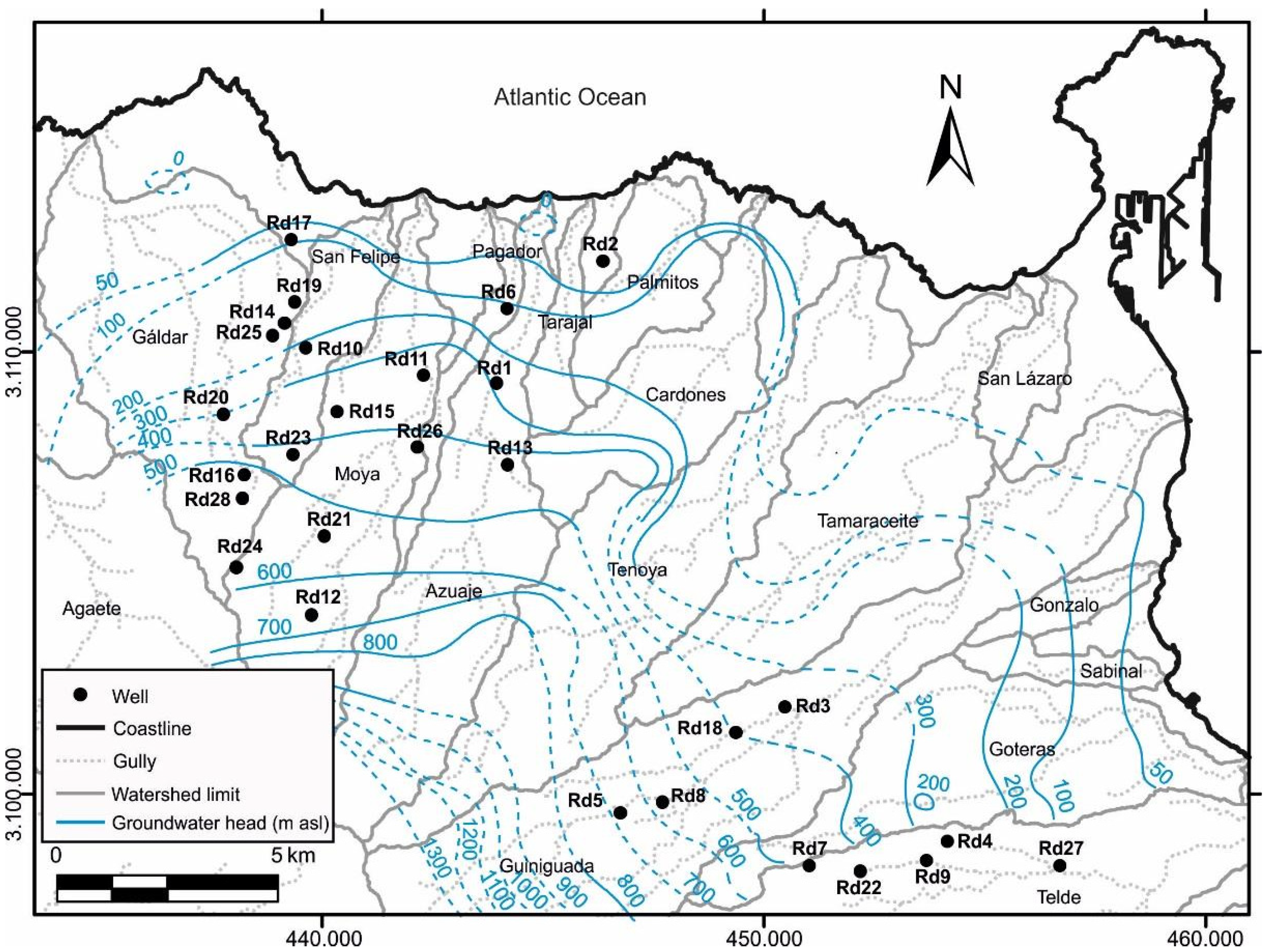
2.3. Hydrogeological and Hydrogeochemical Characteristics
2.4. Area of Study

3. Materials and Methods
3.1. Sample Characteristics and Sampling Procedure
3.2. Equipment Setup

4. Results and Discussion
4.1. Radon as a Natural Radioactive Tracer to Study Aquifer Systems

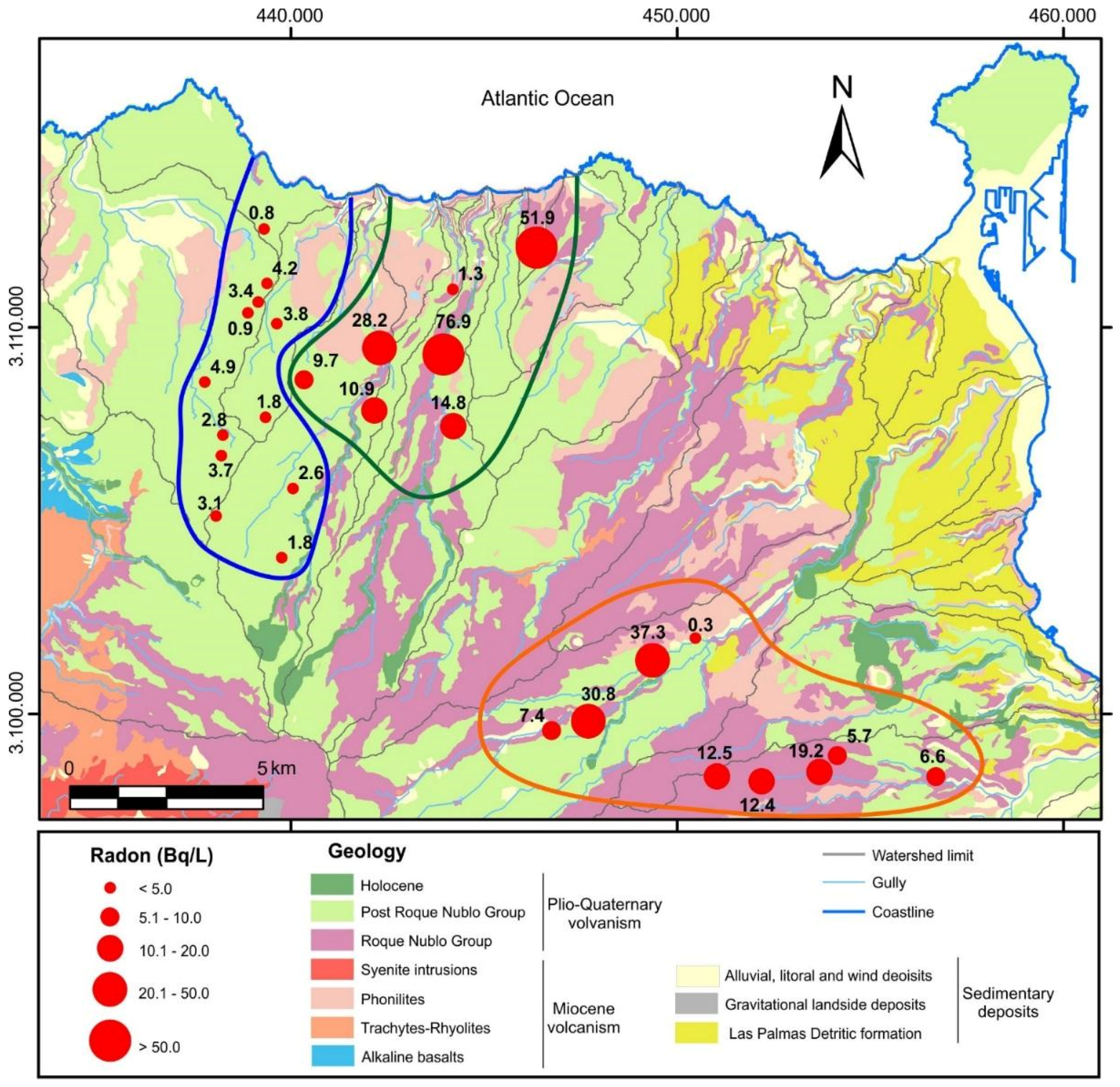
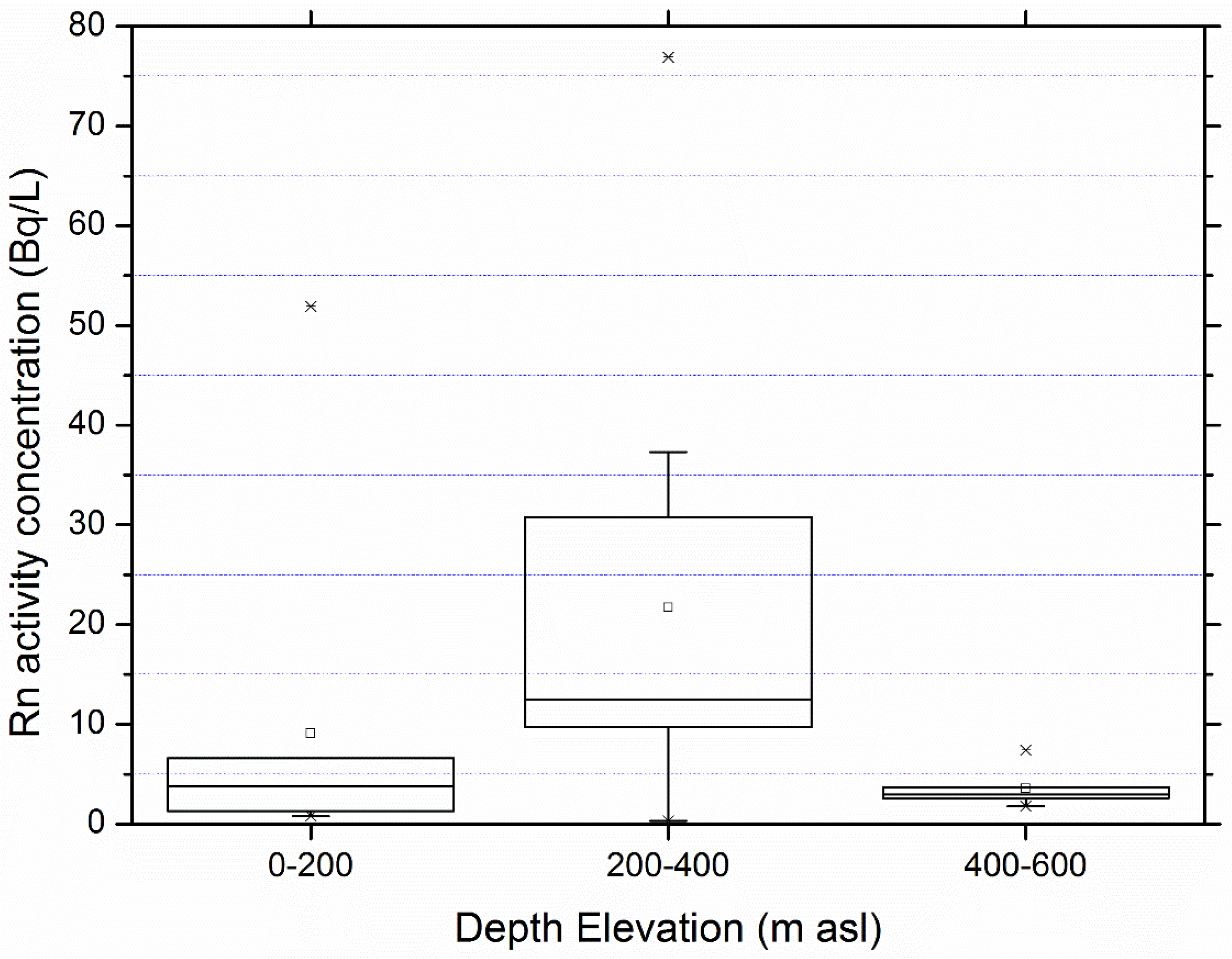
| Samples | Elevation (m above Sea Level) | Depth (m asl) | Depth Elevation (m asl) | Radon Concentration (Bq/L) |
|---|---|---|---|---|
| Rd1 | 235 | 0 | 235 | 76.9 ± 8.3 |
| Rd2 | 108 | 150 | −42 | 51.9 ± 8.9 |
| Rd3 | 430 | 176 | 254 | 0.3 ± 0.3 |
| Rd4 | 354 | 192 | 162 | 5.7 ± 1.9 |
| Rd5 | 725 | 151 | 574 | 7.4 ± 3.7 |
| Rd6 | 235 | 123 | 112 | 1.3 ± 1.0 |
| Rd7 | 679 | 290 | 389 | 12.5 ± 3.1 |
| Rd8 | 603 | 340 | 263 | 30.8 ± 6.4 |
| Rd9 | 345 | 150 | 195 | 19.2 ± 4.6 |
| Rd10 | 515 | 360 | 155 | 3.8 ± 2.4 |
| Rd11 | 377 | 125 | 252 | 28.2 ± 6.1 |
| Rd12 | 996 | 450 | 546 | 1.8 ± 1.0 |
| Rd13 | 499 | 200 | 299 | 14.8 ± 4.1 |
| Rd14 | 452 | 400 | 52 | 0.9 ± 0.8 |
| Rd15 | 620 | 315 | 305 | 9.7 ± 2.6 |
| Rd16 | 740 | 280 | 460 | 2.8 ± 1.2 |
| Rd17 | 260 | 170 | 90 | 0.8 ± 0.8 |
| Rd18 | 523 | 230 | 293 | 37.3 ± 8.1 |
| Rd19 | 420 | 372 | 48 | 4.2 ± 1.9 |
| Rd20 | 625 | 400 | 225 | 4.9 ± 1.7 |
| Rd21 | 810 | 302 | 508 | 2.6 ± 1.4 |
| Rd22 | 481 | 143 | 338 | 12.4 ± 3.3 |
| Rd23 | 750 | 608 | 142 | 1.8 ± 0.9 |
| Rd24 | 1050 | 540 | 510 | 3.1 ± 1.4 |
| Rd25 | 445 | 340 | 105 | 3.4 ± 1.5 |
| Rd26 | 598 | 394 | 204 | 10.9 ± 2.8 |
| Rd27 | 182 | 150 | 32 | 6.6 ± 2.5 |
| Rd28 | 827 | 355 | 472 | 3.7 ± 1.5 |

- (a)
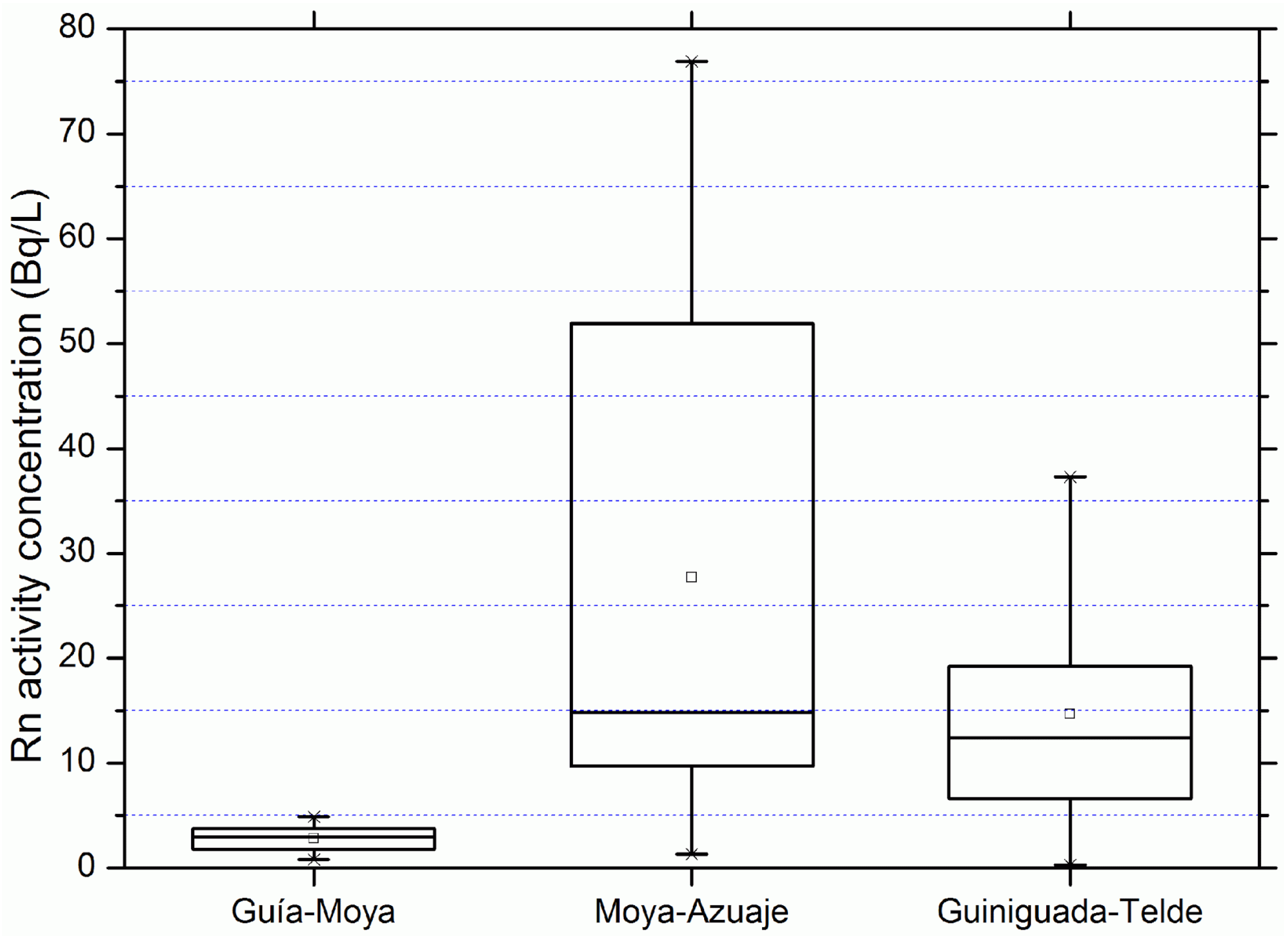
- Northwestern group (Guia-Moya). This group (blue line in Figure 4) has lower radon concentration values (lower than 10 Bq/L) and it is mainly located in the Guía basin but includes some points associated with the Moya basin. The samples included in this group are Rd10, Rd12, Rd14, Rd16, Rd17, Rd19, Rd20, Rd21, Rd23, Rd24, Rd25, and Rd28. Some statistical parameters are: arithmetic mean, 2.82 Bq/L; geometric mean, 2.47 Bq/L; median, 2.95 Bq/L; and standard deviation, 1.29 Bq/L. According to the deep geology of the area (cross section I-I′ in Figure 1), groundwater in these areas flow through basic rocks with little content in radon precursors.
- (b)
- Northwestern group (Guia-Moya). This group (blue line in Figure 4) has lower radon concentration values (lower than 10 Bq/L) and it is mainly located in the Guía basin but includes some points associated with the Moya basin. The samples included in this group are Rd10, Rd12, Rd14, Rd16, Rd17, Rd19, Rd20, Rd21, Rd23, Rd24, Rd25, and Rd28. Some statistical parameters are: arithmetic mean, 2.82 Bq/L; geometric mean, 2.47 Bq/L; median, 2.95 Bq/L; and standard deviation, 1.29 Bq/L. According to the deep geology of the area (cross section I-I′ in Figure 1), groundwater in these areas flow through basic rocks with little content in radon precursors.
- (c)
- Northern group (Moya-Azuaje). This group (green line in Figure 4) has the highest radon concentration values (reaching 76.9 Bq/L) and it is mainly located in the Azuaje basin but includes some points from the Moya basin. The samples included in this group are Rd1, Rd2, Rd6, Rd11, Rd13, Rd15 and Rd26. These data have an arithmetic mean of 27.67 Bq/L; geometric mean of 15.64 Bq/L; median of 14.8 Bq/L; and a standard deviation of 27.31 Bq/L. In this case the high values of radon could suggest that the underlying territory, through which the groundwater flows, has a great proportion of acidic rock with higher contents of radon precursors as shown by the deep geology of the area (cross section II-II′ in Figure 1).
- (d)
- Northeastern group (Guiniguada-Telde). This group (orange line in Figure 4) has intermediate radon concentration values and combines points belonging to both the Guiniguada and Telde basins. The samples included in this group are Rd3, Rd4, Rd5, Rd7, Rd8, Rd9, Rd18, Rd22, and Rd27. These data have an arithmetic mean of 14.69 Bq/L; geometric mean of 8.7 Bq/L; median of 12.4 Bq/L; and a standard deviation of 12.28 Bq/L. The characteristics of this group are similar to the Moya-Azuaje group. Although there is no geological cross section for this area, and many of the wells are located at the Roque Nublo group, phonolite outcrops are observed, so that a greater proportion of basic rock in the subsurface is plausible.
4.2. Radiological Quality of Ground Waters: Radon and Gross Alpha Activity


| Samples | Group | A (Bq/L) |
|---|---|---|
| Rd18 | Northeast | 0.044 ± 0.004 |
| Rd8 | Northeast | 0.172 ± 0.007 |
| Rd9 | Northeast | 1.08 ± 0.02 |
| Rd7 | Northeast | 0.046 ± 0.004 |
| Rd22 | Northeast | 0.034 ± 0.004 |
| Rd1 | North | 0.306 ± 0.004 |
| Rd2 | North | 0.94 ± 0.02 |
| Rd13 | North | 0.004 ± 0.001 |
| Rd11 | North | 0.344 ± 0.009 |
| Rd26 | North | 0.087 ± 0.006 |
5. Conclusions
Acknowledgments
Author Contributions
Conflicts of Interest
References
- Gundersen, L.C.S.; Schumann, R.R.; Otton, J.K.; Owen, D.E.; Dubiel, R.F.; Dickinson, K.A. Geology of radon in the United States. Geol. Soc. Am. Spec. Pap. 1992, 271, 1–16. [Google Scholar]
- Choubey, V.M.; Ramola, R.C. Correlation between geology and radon levels in groundwater, soil and indoor air in Bhilangana Valley, Garhwal Himalaya, India. Environ. Geol. 1997, 32, 258–262. [Google Scholar] [CrossRef]
- Choubey, V.M.; Sharma, K.K.; Ramola, R.C. Geology of radon occurrence around Jari in Parvati Valley, Himachal Pradesh, India. J. Environ. Radioact. 1997, 34, 139–147. [Google Scholar] [CrossRef]
- Skeppström, K.; Olofsson, B. Uranium and radon in ground water. Eur. Water 2007, 17, 51–62. [Google Scholar]
- Schubert, M.; Brueggemann, L.; Knoeller, K.; Schirmer, M. Using radon as an environmental tracer for estimating groundwater flow velocities in single well tests. Water Resour. Res. 2011, 47. [Google Scholar] [CrossRef]
- Ortega, L.; Manzano, M.; Custodio, E.; Hornero, J.; Rodríguez-Arévalo, J. Using 222Rn to identify and quantify groundwater inflows to the Mundo River (SE Spain). Chem. Geol. 2015, 395, 67–79. [Google Scholar] [CrossRef]
- Hoehn, E.; von Gunten, H.R.; Stauffer, F.; Dracos, T. Radon-222 as a groundwater tracer. A laboratory study. Environ. Sci. Technol. 1992, 26, 734–738. [Google Scholar] [CrossRef]
- Crawford-Brown, D.J. Risk and Uncertainty Analysis for Radon in Drinking Water; Final Report; American Water Works Association: Chapel Hill, NC, USA, 1991. [Google Scholar]
- U.S. Environmental Protection Agency (EPA). Cancer Risk Coefficients for Environmental Exposure to Radionuclides; Federal Guidance Report No. 13; EPA: Washington, DC, USA, 1999. [Google Scholar]
- Yu, D.; Kim, K.J. A Physiologically based assessment of human exposure to radon released from groundwater. Chemosphere 2004, 54, 639–645. [Google Scholar] [CrossRef] [PubMed]
- Council Directive 2013/51/EURATOM of 22 October 2013 Laying Down Requirements for the Protection of the Health of the General Public with Regard to Radioactive Substances in Water Intended for Human Consumption. Available online: http://eur-lex.europa.eu/legal-content/EN/TXT/?uri=uriserv:OJ.L_.2013.296.01.0012.01.ENG (accesedd on 25 May 2015).
- Moreno, V.; Bach, J.; Baixeras, C.; Font, L. Radon levels in groundwaters and natural radioactivity in soils of the volcanic region of La Garrotxa, Spain. J. Environ. Radioact. 2014, 128, 1–8. [Google Scholar] [CrossRef] [PubMed]
- Corrêa, J.; Paschuk, S.; Kappke, J.; Perna, A.; França, A.; Schelin, H.; Denyak, V. Measurementsof 222Rn activity in well water of the Curitiba metropolitan area (Brazil). Radiat. Phys. Chem. 2014, 104, 108–111. [Google Scholar] [CrossRef]
- Cosma, C.; Moldovan, M.; Dicu, T.; Kovacs, T. Radon in water from Transylvania (Romania). Radiat. Meas. 2008, 43, 1423–1428. [Google Scholar] [CrossRef]
- Papastefanou, C. An overview of instrumentation for measuring radon in soil gas and groundwaters. J. Environ. Radioact. 2002, 63, 271–283. [Google Scholar] [CrossRef] [PubMed]
- Talha, S.A.; Lindsay, R.; Newman, R.T.; de Meijer, R.J.; Maleka, P.P.; Hlatshwayo, I.N.; Mlwilo, N.A.; Mohanty, A.K. ©-Ray spectrometry of radon in water and the role of radon to representatively sample aquifers. Appl. Radiat. Isot. 2008, 66, 1623–1626. [Google Scholar] [CrossRef] [PubMed]
- Instituto Tecnológico Geominero de España (ITGE). Plan Magna. In Memorias y Mapas Geológicos de España. E:1:25000; ITGE: Isla de Gran Canaria, España, 1990. [Google Scholar]
- PHGC. Actualización del Conocimiento Hidrogeológico de Gran Canaria; Gran Canaria Hydrogeologic Plan Office: Las Palmas de Gran Canaria, España, 1991. [Google Scholar]
- Carracedo, J.C. Growth, structure, instability and collapse of Canarian volcanoes and comparisons with Hawaiian volcanoes. J. Volcanol. Geotherm. Res. 1999, 94, 1–19. [Google Scholar] [CrossRef]
- Carracedo, J.C.; Pérez Torrado, F.J.; Ancochea, E.; Meco, J.; Hernán, F.; Cubas, C.R.; Casillas, R.; Rodríguez Badiola, E.; Ahijado, A. Cenozoic volcanicsm II: The Canary Islands. In The Geology of Spain; Gibbons, W., Moreno, T., Eds.; The Geological Society of London: London, UK, 2002; pp. 439–472. [Google Scholar]
- Perez-Torrado, F.J.; Carracedo, J.C.; Mangas, J. Geochronology and stratigraphy of the Roque Nublo Cycle, Gran Canaria, Canary Islands. J. Geol. Soc. 1995, 152, 807–818. [Google Scholar] [CrossRef]
- Guillou, H.; Pérez-Torrado, F.J.; Hansen-Machin, A.R.; Carracedo, J.C.; Gimeno, D. The Plio-Quaternary volcanic evolution of Gran Canaria based on new K–Ar ages and magnetostratigraphy. J. Volcanol. Geotherm. Res. 2004, 135, 221–246. [Google Scholar] [CrossRef]
- Aulinas, M.; Gimeno, D.; Fernández-Turiel, J.L.; Pérez-Torrado, F.J.; Rodríguez-González, A.; Gasperini, D. The Plio-Quaternary magmatic feeding system beneath Gran Canaria (Canary Islands, Spain): Constraints from thermobarometric studies. J. Geol. Soc. Lond. 2010, 167, 785–801. [Google Scholar] [CrossRef]
- Perez-Torrado, F.J. Volcanoestratigrafía del grupo Roque Nublo (Gran Canaria). Ph.D. Thesis, Universidad de Las Palmas de Gran Canaria, Las Palmas de Gran Canaria, España, 1992. [Google Scholar]
- MOP-UNESCO. Estudio Científico de los Recursos de Agua en las Islas Canarias, Project SPA/69/515 MOP (DGOH)-PNUD (UNESCO); Dirección General de Obras Hidráulicas-UNESCO: Madrid, Spain, 1975. [Google Scholar]
- Cruz-Fuentes, T.; Heredia, J.; Cabrera, M.C.; Custodio, E. Behaviour of a small sedimentary volcanic aquifer receiving irrigation return flows: La Aldea, Gran Canaria, Canary Island (Spain). Hydrogeol. J. 2014, 22, 865–882. [Google Scholar] [CrossRef]
- Cabrera, M.C.; Custodio, E. Groundwater flow in a volcanic-sedimentary coastal aquifer: Telde area, Gran Canaria, Canary Islands, Spain. Hydrogeol. J. 2004, 12, 305–320. [Google Scholar] [CrossRef]
- Benavides, A.; Galindo, E. Evolución de la piezometría de la zona norte de la isla de Gran Canaria. In El Conocimiento de los Recursos Hídricos en Canarias Cuatro Décadas Después del Proyecto SPA-15; Cabrera, M.C., Jiménez, J., Custodio, E., Eds.; Asociación internacional de hidrogeólogos Grupo Español: Las Palmas, Spain, 2010; pp. 53–59. [Google Scholar]
- Estévez, E.; Cabrera, M.C.; Molina-Díaz, A.; Robles-Molina, J.; Palacios-Díaz, M.P. Screening of emerging contaminants and priority substances (2008/105/EC) in reclaimed water for irrigation and groundwater in a volcanic aquifer (Gran Canaria, Canary Islands, Spain). Sci. Tot. Environ. 2012, 433, 538–546. [Google Scholar] [CrossRef]
- SAPHYMO. AlphaGUARD Portable Radon Monitor User Manual; SAPHYMO: Frankfurt am Main, Germany, 1998. [Google Scholar]
- Kotrappa, P.; Sieff, L.R.; Volkovoitsky, P. Radon monitor calibration using NIST radon emanation standards steady flow method. Radiat. Prot. Dosim. 2005, 113, 70–74. [Google Scholar] [CrossRef] [Green Version]
- SAPHYMO. AquaKIT user manual. In Accesory for Radon Water Measurement in Combination with the Radon Monitor AlphaGUARD; SAPHYMO: Frankfurt am Main, Germany, 2007. [Google Scholar]
- Schubert, M.; Buerkin, W.; Peña, P.; López, A.E.; Balcázar, M. On-site determination of the radon concentratiom in water samples: Methodical background and results from laboratory studies and a field-scale test. Radiat. Meas. 2006, 41, 492–497. [Google Scholar] [CrossRef]
- Kendall, C.; McDonnell, J.J. Isotope Tracers in Catchment Hydrology; Elsevier: New York, NY, USA, 1998; p. 839. [Google Scholar]
- Mullinger, N.J.; Pates, J.M.; Binley, A.M.; Cook, N.P. Controls on the spatial and temporal variability of 222Rn in riparian groundwater in a low land Chalk catchment. J. Hydrol. 2009, 376, 58–69. [Google Scholar] [CrossRef]
- Przylibski, T.A. Radon as a natural radioactive tracer for studying crystalline rock aquifers–a few usage concepts. Acta Univ. Wratislav. 2007, 3041, 125–142. [Google Scholar]
- Przylibski, T.A.; Gorecka, J. 222Rn activity concentration differences in groundwaters of three Variscan granitoid massifs in the Sudetes (NE Bohemian Massif, SW Poland). J. Environ. Radioact. 2014, 134, 43–53. [Google Scholar] [CrossRef] [PubMed]
- Eisenbud, M.; Gessell, T. Environmental Radioactivity. From Natural, Industrial and Military Sources, 4th ed.; Academic Press: San Diego, CA, USA, 1997. [Google Scholar]
- Naranjo, G; Cruz-Fuentes, T.; Cabrera, M.C.; Custodio, E. Estimating natural recharge by means of chloride mass balance in a volcanic aquifer: North-eastern Gran Canaria (Canary Islands, Spain). Water. in press.
- International Commission on Radiological Protection (ICRP). Age dependent Doses to Members of the Public from Intake of Radionuclides, Part 5 Compilation of Ingestion and Inhalation Dose Coefficients. In Annals on the ICRP, ICRP Publication 72; Pergamon Press: Oxford, UK, 1996. [Google Scholar]
- Aieta, E.M.; Singley, J.E.; Trussell, A.R.; Thorbjarnarson, K.W.; McGuire, M.J. Radionuclides in Drinking Water: An Overview. J. Am. Water Works Assoc. 1987, 79, 144–152. [Google Scholar]
- Salonen, L. 238U series radionuclides as a source of increased radioactivity in groundwater originating from Finnish bedrock. In IAHS Publications-Series of Proceedings and Reports-International Association Hydrological Sciences; Great Britain Institute of Hidrology: Wallingford, Great Britain, 1994; Volume 222, pp. 71–84. [Google Scholar]
- Suárez-Navarro, J.A.; Pujol, L.; de Pablo, M.A. Rapid determination of gross alpha-activity in sea water by coprecipitation. J. Radioanal. Nuclear Chem. 2002, 253, 47–52. [Google Scholar] [CrossRef]
- Procedimiento Para la Determinación del Índice de Actividad alfa Total en Muestras de Agua. Métodos de Coprecipitación y Evaporación. Available online: http://www.csn.es/publicaciones/pro_09.pdf (accessed on 31 March 2015).
© 2015 by the authors; licensee MDPI, Basel, Switzerland. This article is an open access article distributed under the terms and conditions of the Creative Commons Attribution license (http://creativecommons.org/licenses/by/4.0/).
Share and Cite
Alonso, H.; Cruz-Fuentes, T.; Rubiano, J.G.; González-Guerra, J.; Cabrera, M.D.C.; Arnedo, M.A.; Tejera, A.; Rodríguez-Gonzalez, A.; Pérez-Torrado, F.J.; Martel, P. Radon in Groundwater of the Northeastern Gran Canaria Aquifer. Water 2015, 7, 2575-2590. https://doi.org/10.3390/w7062575
Alonso H, Cruz-Fuentes T, Rubiano JG, González-Guerra J, Cabrera MDC, Arnedo MA, Tejera A, Rodríguez-Gonzalez A, Pérez-Torrado FJ, Martel P. Radon in Groundwater of the Northeastern Gran Canaria Aquifer. Water. 2015; 7(6):2575-2590. https://doi.org/10.3390/w7062575
Chicago/Turabian StyleAlonso, Héctor, Tatiana Cruz-Fuentes, Jesús G. Rubiano, Jonay González-Guerra, María Del Carmen Cabrera, Miguel A. Arnedo, Alicia Tejera, Alejandro Rodríguez-Gonzalez, Francisco J. Pérez-Torrado, and Pablo Martel. 2015. "Radon in Groundwater of the Northeastern Gran Canaria Aquifer" Water 7, no. 6: 2575-2590. https://doi.org/10.3390/w7062575
APA StyleAlonso, H., Cruz-Fuentes, T., Rubiano, J. G., González-Guerra, J., Cabrera, M. D. C., Arnedo, M. A., Tejera, A., Rodríguez-Gonzalez, A., Pérez-Torrado, F. J., & Martel, P. (2015). Radon in Groundwater of the Northeastern Gran Canaria Aquifer. Water, 7(6), 2575-2590. https://doi.org/10.3390/w7062575