Article

A Participatory Approach for Adapting River Basins to Climate Change

by
Pieter Johannes Verkerk
1,*,
Anabel Sánchez
2,
Steven Libbrecht
3,
Annelies Broekman
2,
Adriana Bruggeman
4,
Hamed Daly-Hassen
5,
Elias Giannakis
4,
Sihem Jebari
5,
Kasper Kok
6,
Aleksandra Krivograd Klemenčič
7,8,
Manca Magjar
7,
Inazio Martinez de Arano
1,
Nicolas Robert
1,
Nataša Smolar-Žvanut
7,
Elsa Varela
1 and
Christos Zoumides
4
1
Mediterranean Regional Office, European Forest Institute, St. Antoni M. Claret 167, 08025 Barcelona, Spain
2
Centre for Ecological Research and Forestry Applications, 08193 Cerdanyola del Vallès, Spain
3
Prospex bvba, Vlugestal 6, B-3140 Keerbergen, Belgium
4
Energy, Environment and Water Research Center, The Cyprus Institute, 20 Konstantinou Kavafi Street, Nicosia 2121, Cyprus
5
National Research Institute of Rural Engineering, Water and Forests, Rue Hedi Karray, Ariana 2080, Tunisia
6
Soil Geography and Landscape Group, Wageningen University, Droevendaalsesteeg 3, 6708 PB Wageningen, The Netherlands
7
Institute for Water of the Republic of Slovenia, Dunajska cesta 156, SI-1121 Ljubljana, Slovenia
8
Faculty of Civil and Geodetic Engineering, University of Ljubljana, Jamova 2, SI-1000 Ljubljana, Slovenia
*
Author to whom correspondence should be addressed.
Water 2017, 9(12), 958; https://doi.org/10.3390/w9120958
Submission received: 16 June 2017 / Revised: 1 December 2017 / Accepted: 5 December 2017 / Published: 8 December 2017

Abstract

:
Climate change is expected to reduce water availability in the Mediterranean region and water management needs to adapt to future conditions. The aims of this study were (1) to develop a participatory approach for identifying and evaluating management options for river basin climate adaptation and (2) to apply and evaluate the approach in four case-study river basins across the Mediterranean. As part of the approach, a diverse group of stakeholders joined a series of workshops and consultations in four river basins located in Cyprus, Slovenia, Spain and Tunisia. In each river basin, stakeholders expressed their views on challenges in their river basins, as well as options to tackle these challenges. We used the information on challenges, as well as the factors contributing to these challenges to develop a fuzzy cognitive map for each basin. These maps were converted into mathematical models and were used to assess the impact of a total of 102 suggested management options for the four river basins. We linked the options and their estimated impacts with a multi-criteria analysis to identify the most preferred options. The approach was positively evaluated by the participating stakeholders and allowed the link of stakeholders’ knowledge and perceptions about their river basin with their preferences for options to adapt the management of their river basins to future conditions.

1. Introduction

Society crucially depends on access to high quality water resources. Unfortunately, water resources are limited and climate change is expected to exacerbate water scarcity [1,2], particularly affecting drier regions such as the Mediterranean. Temperatures are expected to increase, seasonal precipitation patterns are expected to shift and extreme events (heatwaves, droughts, heavy rain) are projected to become more frequent and intense [3]. Despite the uncertainties in climate model simulations, the projections for the Mediterranean area indicate a strong consistency in reduced future availability of water [4].
Climate change impacts should be analyzed together with other factors that influence water resources. The population in the Mediterranean has been growing significantly in recent decades and this trend is expected to continue during the next decades, especially in the Southern part of the Mediterranean [5]. Furthermore, land cover and land use influence both the amount and the quality of available water [6,7]. Humans have modified Mediterranean landscapes for millennia [8] and the area has experienced urban expansion in coastal areas and contraction of croplands during recent decades, followed by an expansion of the forest area [9,10]. Water is already under high demand due to agriculture, urbanization and tourism with negative consequences on water quality [11,12,13]. The demand for water is estimated to increase in the future and may lead to further pressure on water availability and quality [14,15]. Altogether, these constraints indicate the need to develop water management strategies to adapt to future conditions.
To ensure that adaptation strategies for water management are credible, informed and achievable, they need to be developed through an open and transparent process with the active participation of diverse stakeholders, representing different sectors and policy areas in the river basin [13,16,17]. Stakeholder participation in water management planning is thought to (i) contribute to acceptability, sustainability and resilience in water projects and policies; (ii) strengthen capacity building and empowerment; (iii) guarantee equity and democracy in decision making; (iv) provide solutions for conflict situations; and (v) contribute to economic efficiency [18,19,20]. The importance of involving stakeholders in decision-making is increasingly acknowledged at the policy level. For example, the European Union’s Water Framework Directive (Directive 2000/60/EC) requires public consultation in the water management planning process. However, this directive neither prescribes how public participation should be operationalized [21], nor does it explicitly consider climate change [22].
Numerous studies have developed and applied participatory approaches for climate change adaptation [23,24,25], including for the management of water resources under climate change [26,27]. Quantitative simulation models are frequently used to provide detailed and important insights in the effects of water management under climate change [28,29,30]. The use of such quantitative and often complex models in participatory processes is not straightforward, as such models may be perceived by stakeholders as black-boxes. Furthermore, data to feed quantitative models may not always be available, and semi or non-quantitative, participatory modelling methods may be a suitable approach to deal with data gaps. Participatory modelling methods have been developed and used to enhance stakeholders’ knowledge and understanding of a system (e.g., a river basin) and its dynamics and to assess impacts of policies or management strategies [31]. In this study, we applied such a participatory modelling method and combined it with a multi-criteria analysis in an attempt to involve stakeholders from four river basins across the Mediterranean to plan for the adaptation of the management of their river basins. The aims of this study were (1) to develop a participatory approach for identifying and evaluating management options for river basin adaptation planning and (2) to apply and evaluate the approach in four case-study river basins across the Mediterranean.

2. Materials and Methods

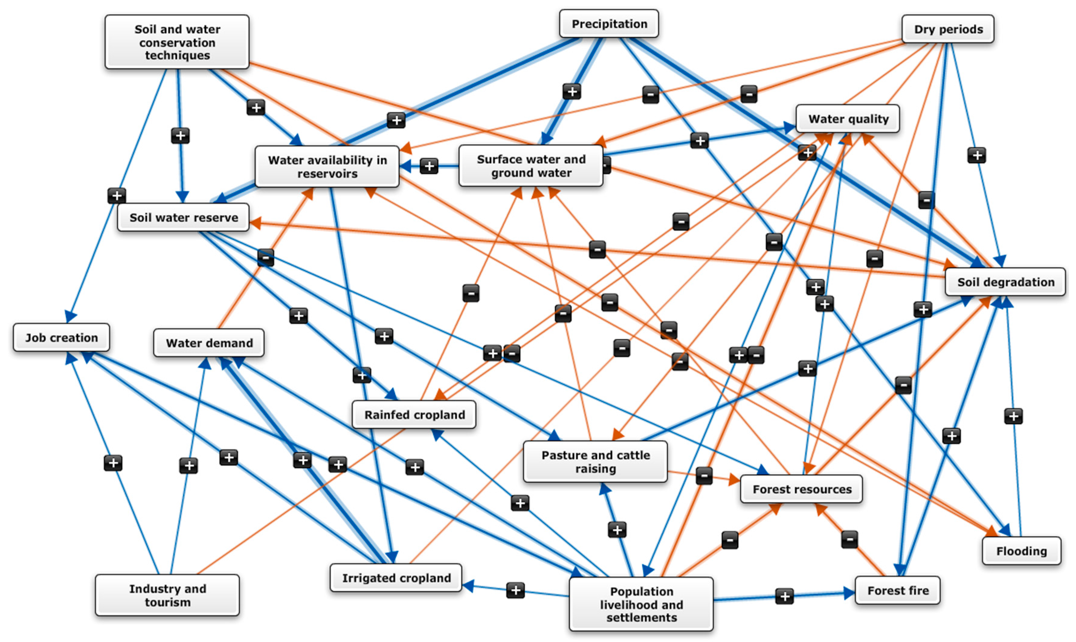
2.1. Case-Study Approach

To formulate and evaluate water management options, we focused on four Mediterranean case study river basins, which are located across the Mediterranean area: the Pedieos river basin (Cyprus) in the east, the Rmel river basin (Tunisia) in the south, the Tordera river basin (Spain) in the west, and the Vipava river basin (Slovenia) in the north. The four river basins cover different Mediterranean conditions with regard to climate, land use and socio-economic conditions (Table 1).

2.2. Stakeholder Participation

Stakeholders played a central role in the approach to identify and evaluate management options for each of the four river basins. To involve them, we built on the Stakeholder Integrated Research (STIR) approach [32], which was developed as a structured approach for stakeholder engagement in climate change adaptation. The STIR approach consists of a number of steps, including stakeholder identification and selection, and engages them in a carefully designed and professionally facilitated process, building on scientific methods. While the STIR approach provides a general framework for stakeholder participation, the approach does not prescribe individual methods to be used in all these steps. We identified and applied specific methods for each step in the STIR approach as shown in Table 2.
We identified stakeholders as any group or individual who is affected by or can affect the preparation of water adaptation options in each of the four case study river basins (adapted from [33]). We identified stakeholders for each river basin by following the Criteria–Quota–Individuals method [32] to ensure diversity and representativeness in the group of workshop participants. In practice, stakeholder groups were identified, starting from broad categories (academia, civil society, media, environment, business, policy) and gradually refining to sectors (e.g., water, energy, textile, tourism) relevant for each of the river basins. Subsequently, we identified individuals belonging to these categories and sectors to create a pool of candidate participants to the stakeholder workshops and consultations. Next, multiple criteria were stated together with quota to guide the selection of participants to be invited for a stakeholder workshop, out of the pool of candidate participants. As an example, gender would be a criterion and the quotum would be 30%, implying that the aim would be to achieve a participant group composition with at least 30% of either gender. In reality, it was not always possible to achieve the pre-defined group composition due to late cancellations or replacements of individuals.
To integrate these stakeholders in the process, we invited them to two major participatory workshops in each river basin, complemented with additional consultations or events to ensure their engagement throughout the process (Table 3). All workshops and consultations were held in the local language (i.e., Greek, Arabic, Catalan and Slovenian). The interactions took place at key stages of the process (as outlined in Section 2.3, Section 2.4 and Section 2.5) to ensure the provision of the required information for each step in our approach.

2.3. Eliciting Expectations

To identify the issues to be tackled in each river basin, we elicited stakeholders’ expectations for river basin management during Stakeholder workshop I. Stakeholders that could not participate in the workshops were interviewed. During these workshops and interviews, we presented and discussed the results of previous (quantitative) studies on the potential future impacts of climate change and other relevant factors (e.g., population development, land use change, etc.) on their river basins. In a next step, we asked participants “From your perspective, what are the biggest challenges in the medium-long term for this river basin?” and “If you are allowed to dream, and looking from your perspective, what should water management have achieved by 2030, in this river basin?” Workshop participants addressed these questions during group discussions and we captured their responses by taking notes and photographs of the post-its they filled-in and placed on flip-charts during the discussions. The interviewed stakeholders responded to the same set of questions and their answers were captured by taking notes.
All the information obtained during the workshops and interviews was organized and synthesized by the researchers into narratives for each basin. These narratives described stakeholders’ beliefs and expectations for management of each river basin along a common storyline. Each narrative consisted of a text and a graphic. The text described the context, the status and the challenges of water management in the river basins verbally. The graphic consisted of a Fuzzy Cognitive Map (FCM) [34,35,36,37,38]. A FCM is a graphical representation of the dynamics in a system—a river basin in this case—based on the understanding of individuals and can include local and expert knowledge. The components (factors) are represented as boxes and relationships as arrows. The arrows reflect the sign and strength of the relationships between the factors. FCMs can be converted into simple mathematical models to assess the impact of management options on river basins.
We constructed FCMs using Mental Modeler (http://www.mentalmodeler.org/), based on statements provided by the participants in the stakeholder workshops and interviews. Factors in the FCMs could be challenges, drivers, or other aspects that describe the river basin system. Challenges represented issues that require attention in the years to come, as indicated by stakeholders in their responses to the abovementioned questions. Next, we identified drivers, which are factors that exert influence on the system, but are not affected by other factors in the system. We systematically included water quality and water quantity among the challenges in each basin, as our study intended to contribute to the development of adaptation plans for each river basin, but we did not prescribe any other factors. After identifying all relevant factors, we connected these factors with arrows and qualified the relationships as being positive or negative. A positive relationship indicates a positive causality, i.e., a factor that receives a positive arrow changes in the same direction as the factor sending the arrow, while a negative arrow indicates a negative causality. Finally, we assigned strengths to these relationships. To facilitate interaction with stakeholders, relationships were expressed in seven classes: strong (+++ or –––), medium (++ or ––), weak (+ or –) or no relationship.
On the basis of the first versions of the FCMs, we consulted the stakeholders in the Rmel, Tordera and Vipava river basins and expert stakeholders and researchers in the Pedieos river basin (stakeholder consultation I; Table 3). This consultation was done in the form of interviews in the Vipava river basin and in a workshop setting in the three other basins. Stakeholders commented on the FCMs and suggested factors and relationships to be added, removed or modified. After the consultations in each of the four river basins, we refined the FCMs [39]. These refinement steps resulted in a final version of a FCM, as well as the narrative, for each basin, which we presented to stakeholders in Stakeholder workshop II.

2.4. Formulating Management Options

To address the challenges specified by the participants of Stakeholder workshop I and the subsequently interviewed stakeholders, they also were asked to respond to the question: “What options do you see to help achieve that desired state by 2030?” Suggestions made by stakeholders were formulated as options. Each option was characterized using a set of pre-defined descriptors (Table S1 in the Supplementary Materials). Using this characterization, we checked for gaps and redundancies in the identified options, such that each challenge was addressed by multiple options and that options represented different types of solutions (e.g., options addressing water demand and options addressing water supply). After these checks, we prepared a first list of synthesized options and discussed it with participants of Stakeholder workshop II. In this workshop, participants discussed the descriptions of the options. In several cases, they asked for refining, improving or correcting the formulation of the options. These comments were recorded and used to develop a second version of the options list. This revised list was presented and discussed during stakeholder consultation II. This iterative approach resulted in a final set of options for each basin.

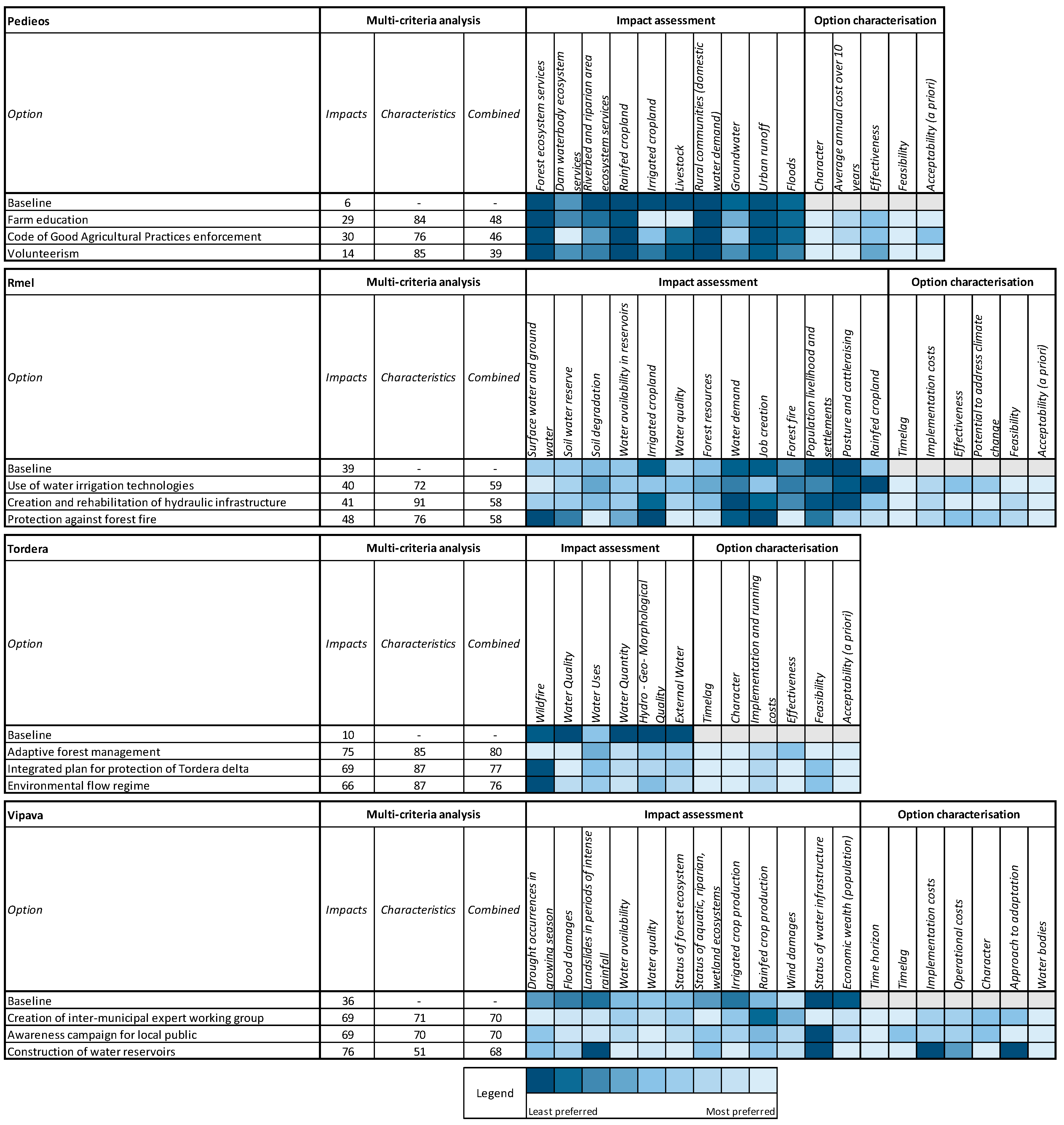
2.5. Evaluating Management Options

2.5.1. Impact Assessment

We used the FCMs to assess how the management options would affect each river basin. To do this, the FCMs were converted to mathematical models [36,37] in Excel (Microsoft Corporation, 2016, Redmond, WA, USA). The models for Rmel, Tordera and Vipava were implemented as linear models. We assigned an initial value of 1 to drivers that were expected to increase in the future (e.g., temperature), an initial value of −1 to drivers that were expected to decrease in the future (e.g., precipitation) and an initial value of 0 to all other factors (i.e., non drivers) in the map. Whether a driver was expected to increase or decrease was determined based on the literature. The strength of the relationships between factors was converted to semi-quantitative values; we assigned the values 0.3, 0.6 and 0.9 to indicate weak, medium, and strong relationships, respectively. By iteratively multiplying the initial values of all factors with the strength of the relationships, we investigated how the change in drivers would affect the dynamics in each basin. The models converged generally within 30 iterations. For Pedieos, a non-linear model was developed; a sigmoid (logistic) function (see e.g., [40]) was used to normalize all factors before each multiplication. This was done to prevent oscillations caused by the multiplication of negative relations with negative values and resulted in a physically expected behavior of the map. A starting value of 0.659 was taken for the drivers and 0.5 for all other factors (these values are the transformation of 1 and 0, respectively, with the sigmoid function). The values of all factors stabilized within eight iterations.
For all basins, we assessed the impacts of the options by (i) changing existing relationships between factors; (ii) introducing new relationships; (iii) introducing new factors and relationships, or by a combination of these three possibilities. The decision on how to implement an option was based on the description of each option separately. For example, an option suggesting the reconstruction of an existing irrigation system was introduced by modifying arrows already included in a FCM, while an option suggesting the construction of a new irrigation system was introduced by adding a new factor and arrow. To avoid the loss of relationships in case of reduced intensity of “weak” relationships (i.e., one + or one −) we added a “very weak” category (+0.1 for positive relationships and −0.1 for negative relationships). By comparing the new equilibrium from the modified model for each option with the baseline model, we were able to assess the impacts of all options for each basin separately.

2.5.2. Multi-Criteria Analysis

Following the impact assessment, we conducted a multi-criteria analysis to be able to compare and prioritize the identified options, based on their characteristics and impacts on the basin. We prepared a list of criteria composed of the set of descriptors that characterize the options (e.g., cost, efficiency, feasibility, acceptability), as well as the factors from the FCMs (excluding drivers) as potential criteria to be considered in the analysis. From this list, the participants of Stakeholder workshop II selected the criteria that should be considered in the evaluation of the options. They also indicated what values of each criterion would represent the most and least preferred outcome. Finally, participants assigned individually a weight to each criterion on an ascending scale of 1 to 10, depending on their preferences. To evaluate the management options we combined (i) the scores and weights of the criteria given by the stakeholders; (ii) the characterization of the management options and (iii) the normalized (based on the minimum and maximum values of the data range for each factor over all options) outcomes of the impact assessment. We averaged the evaluation of the management options over all workshop participants and presented the outcome of the multi-criteria analysis to the stakeholders at the end of Stakeholder workshop II. Taking into account their feedback, we made corrections to the formulation of some of the management options. Final versions of the options were presented to and discussed with stakeholders in Stakeholder consultation II.

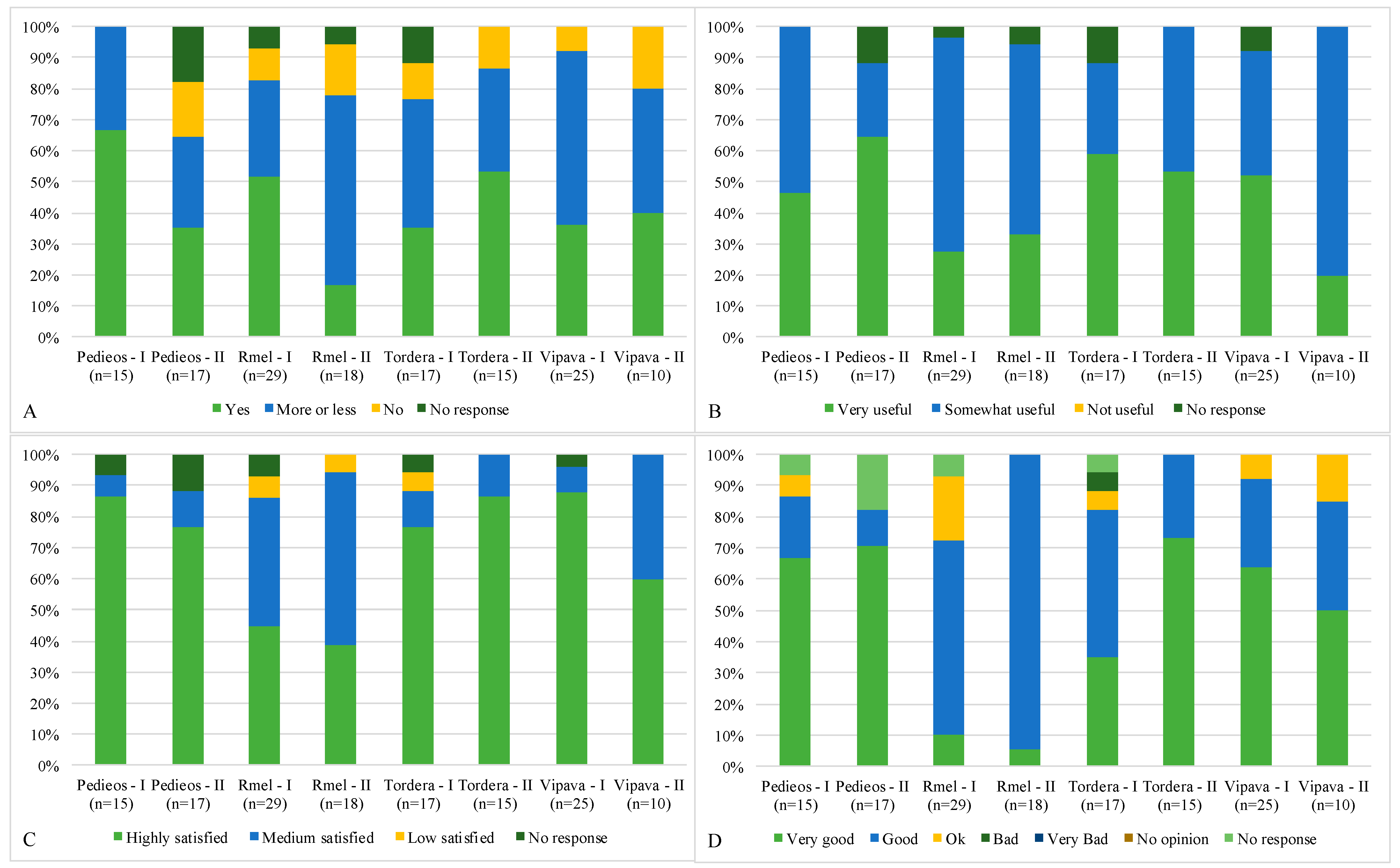
2.6. Evaluating the Approach

To evaluate our approach, most participants of Stakeholder workshops I and II—with the exception of a few that left before the end of the workshop—completed an evaluation questionnaire. The questionnaire included questions including: (1) do you believe that basin stakeholders have the necessary knowledge and the skills to influence local policies in issues regarding climate change and adaptation; (2) do you consider the involvement of stakeholders in the process of developing climate change adaptation plans useful; (3) are you satisfied with how the workshops included your opinions and views; and (4) how do you rate the workshops in general?

3. Results

3.1. Challenges and Options for River Basin Management

Stakeholders highlighted three to five challenges in each of the four river basin. For a complete description of these challenges, we refer to [41,42,43,44]. These challenges included water quantity and water quality in all four river basins. Flooding-related challenges were identified in both the Pedieos and Vipava river basins, while the status of forests represented challenges in Rmel and Tordera. Awareness of civil society and Integrated Water Management were specific challenges for the Rmel and Tordera river basins, resp. Multiple factors affected these challenges and such factors included climate variables, population development, but also various land use sectors (Figure 1, Figures S1–S4 and Tables S2–S9 of the Supplementary Materials).
Agriculture and forestry were included in all four FCMs as land use sectors influencing the river basins’ dynamics. In the Pedieos, Rmel and Vipava river basins, a separation was made between rainfed crop production and irrigated crop production. In the Tordera river basin, irrigation was also considered, but embedded into different land exploitation regimes: extensive and intensive agriculture. In the Pedieos and Rmel basins, livestock was considered as a third agricultural land use sector. In the Pedieos river basin, irrigated agriculture was considered to have a negative effect on water quantity and quality, whereas rain-fed agriculture had no impact on water resources. In the other three basins, agriculture negatively affected water quantity and water quality. In all four maps, forests affected water availability and the relationship was considered positive in three out of the four basins. Stakeholders in the Rmel river basin considered that forests affect water availability negatively, because trees consume water from aquifers. In the case of the Pedieos, Rmel, and Vipava basins, forests positively affect water quality by protecting soil from degradation and minimizing soil erosion on site, and through trapping or filtering other water pollutants. In the Tordera river basin, the relation between water quality and forests was considered indirectly, i.e., the relationship was included through linkages with other factors in the map.
A total of 102 management options were identified and formulated to address the challenges in the Pedieos (30 options), Rmel (19 options), Tordera (33 options), and Vipava (20 options) river basins. The definition and evaluation of all these options are documented in detail in [41,42,43,44]. Here we focus on the three highest-ranked options for each basin. In Figure 2, the outcomes of the impact assessment with the FCMs and the characterization of management options are shown as heatmaps. The results of the impact assessment indicate that management options can improve the overall dynamics in each river basin, compared to their baseline conditions (i.e., a situation where no management options are assumed). For example, the highest-ranked option for Tordera was the option Adaptive Forest Management, which aimed to foster pilot cases for specific adaptive forest management agreements between forest landowners and the local administration. By reducing uncontrolled biomass accumulation, stakeholders considered this option could help to reduce forest evapotranspiration and wildfire risk, as well as improving forest health. The impact assessment with the FCM supported this assertion and also indicated this option could have positive impacts on biodiversity and would increase water quantity in rivers and aquifers. Results of the impact assessment for this option, as well as other options in other basins, indicate that due to feedbacks in the river basin systems not all options have a positive impact on all factors. For example, improved water quantity in the Tordera river basin was considered to stimulate water uses and this was considered an undesirable development according to the outcomes of the multi-criteria analysis. In fact, none of the 102 options that were proposed and analyzed were fully in agreement with the preferences stated by workshop participants with regards to the characteristics and impacts of the options. Moreover, the results suggest that the preference for particular options is to a larger extent determined by their characteristics, rather than by their impacts on the river basin systems.

3.2. Stakeholder Evaluation of the Process

Results of the evaluations carried out at the end of Stakeholder workshops I and II are shown in Figure 3. Across all basins and workshops, 83% of the participants indicated that stakeholders have (to some extent) the necessary knowledge and the skills to influence local policies on issues regarding climate change and adaptation (Figure 3A). Only 12% of the respondents answered no to the question whether stakeholders would be able to influence local policies on issues regarding climate change and adaptation, indicating some scepticism towards the uptake of their contribution in possible decision-making processes. Yet, the majority of the respondents indicated they considered their involvement in the process very useful (45%) or somewhat useful (50%) and no respondent considered participation not useful (Figure 3B). This outcome reflects the endorsement given by the stakeholders to the participatory approach, which is a condition for successful stakeholder engagement. With regards to our approach, 68% of the respondents were highly satisfied, 24% were medium satisfied and 3% were not satisfied with the way the workshops allowed them to express their perspectives and the extent to which their arguments were taken into account. A similar pattern in responses can be seen for the response on the evaluation of the workshop (irrespective of their rating of the facilitators, content supporters, reporters, venue, etc.). In general, the participants positively evaluated the workshops; 87% of the respondents rated the workshops as good or very good, sometimes even going up to 100% (second workshops in the Rmel and Tordera basins). For none of the workshops did participants rate the workshop as very bad and only one participant of the first workshop in Tordera gave a bad rating (Figure 3D).

4. Discussion

To plan the adaptation of river basin management to future climate conditions, we presented a bottom-up approach to ensure that stakeholders from local societies can play an active role and become engaged in selecting suitable options to manage river basins. Our approach is a variant of the STIR approach [32] and we elaborated this approach by focusing on methods to capture the stakeholders’ knowledge and understanding of a river basin, as well as their preferences for management options to address issues at hand. Specifically, we adapted the STIR approach to the context in four Mediterranean river basins and applied it to guide the overall participatory process. As an innovation, we applied this approach by using and linking a participatory modelling method to assess impacts of management options with a multi-criteria analysis. The outcomes of the analyses contributed to the development of four river basin adaptation plans (see [41,42,43,44]).
FCMs have been applied in previous water management studies to gain a shared understanding of the dynamics of their study object or to assess impacts of (few) management options [21,45,46], but it has, to our knowledge, not been combined before with a multi-criteria analysis. The combination of these methods, however, was a valuable step to evaluate the impacts of 102 options in total, taking into account the stakeholder preferences in the evaluation of the options. Combining these two methods revealed that while the four river basins faced similar challenges, stakeholders in these basins had different preferences to address these challenges. Stakeholders in the Pedieos and Vipava basins generally preferred options that target or involve society through awareness campaigns or education and for options to improve the knowledge basis of water management through improved monitoring or hydrological studies. Stakeholders in the Tordera basin preferred mostly green options that addressed important ecosystems in the basin (i.e., forests, water, wetlands) and soft approaches to better prevent over-exploitation of water resources. The most preferred option in this forested basin targeted adaptive forest management, as stakeholders considered forest management as a key issue to address climate change impacts. Finding optimal integrated forest and water management interventions [47] are needed to benefit both forest and water ecosystems. In general, the suggested water management options for the Pedieos, Tordera and Vipava could be characterized by requiring minor or moderate investment or operational costs and give limited space for potential conflicts. Strikingly, technological solutions, such as irrigation, were mentioned by stakeholders but were not amongst the most preferred options in these three basins. Giannakis et al. [48] suggested that one reason for the limited uptake of irrigation could be related to the aging and less trained farm population, the small farm size, the low level of farm investments and the low water price elasticities. Increased support for farm training schemes, including issues such as agro-ecological innovation, water conservation and climate change mitigation and adaptation, could improve the knowledge and skills of farmers and foster the adoption of new technologies [49]. Stakeholders in the Rmel basin had different preferences for water management options as compared to the other three basins, which may be explained by different socio-economic conditions. Important options were those that improved or developed water infrastructures or options that aim to generate income and jobs. Altogether, these results indicate that while river basins can have similar challenges, (preferred) solutions to these challenges may be different.
Our approach provided the tools to understand the dynamics of a river basin and to evaluate identified management options. For example, some stakeholders in the first workshop proposed the demolition of the dam in the Pedieos river basin as an adaptation option. The creation and application of the FCM brought a more general understanding about the potential effects of this option, such as flooding in the downstream urban areas. The FCM application also showed that another proposed option (dynamic dam management) could maintain the ecosystems services of the dam reservoir, release surface water for biodiversity downstream of the dam, and improve groundwater recharge of the alluvial river aquifer downstream. In general, our approach provided a neutral and objective framework to guide the stakeholder discussions. Stakeholders actively participated and highly appreciated the approach and their involvement, as demonstrated by the positive evaluations of the events.
We elaborated and tested our approach to identify management options for four river basins across the Mediterranean. To facilitate the application of our approach in other settings, we here document lessons learned during the process. First, through a specified stakeholder identification procedure [32], we attempted to include a broad range of views on water management in each of these river basins. Obviously, we could only include views and preferences of the stakeholders that participated in the different workshops and consultations, although an effort was made in the Pedieos river basin to involve also the general public [50]. The incorporation of only the perceptions and preferences of stakeholders that participated in the process may have affected the outcomes of the FCMs and multi-criteria analysis. To avoid the exclusion of important views and perceptions, we discussed all analyses with stakeholders in multiple events. Each of these events included stakeholders new to the process and they generally did not disagree when we presented results from previous workshops. The inclusion of new stakeholders during the process, in addition to stakeholders participating in all events, helped to verify the results obtained throughout the process.
Second, a careful balance is needed between providing stakeholders with relevant information and directing the workshops to particular outcomes. We tried to avoid introducing bias by carefully planning each stakeholder workshop through a clear process design and by defining the roles of scientists (focusing on the scientific methodology) and facilitators (focusing on the participatory approach) that were guiding the process. Yet, some steering of the process is unavoidable. For example, participants of Stakeholder workshop I were informed about the potential impacts of global change, including climate change, based on the existing scientific knowledge. Providing such information could have influenced the specification of the challenges in each basin. Furthermore, stakeholders provided many suggestions for water management options and researchers processed these suggestions and prepared a list of synthesized options. This processing may have influenced the formulation of the options in each basin. However, in subsequent events, stakeholders new to the process did not question the challenges or the suggested options. Hence, we believe that the information provided and the processing of information did not influence the identification of challenges to a considerable extent.
Third, the outcomes of our analyses of management options are largely based on the FCMs. We constructed the FCMs on the basis of statements by stakeholders expressed during Stakeholder workshop I and the subsequent interviews, and then discussed the FCMs during workshops and interviews with (expert) stakeholders who could propose modifications. FCMs can, however, be constructed with different levels of stakeholder involvement, ranging from desk research [37], interviews [21] to workshops [38,40,51]. While we did not develop the FCMs in a workshop setting, we believe that such a setting could enhance the involvement of the stakeholders and enable them to better understand the role of the maps in our analyses. Developing FCMs is possible within a one- to two-day workshop [51], but in our experience a refinement of the map would be needed before its use as a tool for assessing impacts of management options.
Altogether, our approach allows identifying locally-relevant challenges for the management and adaptation of river basins, understanding how these challenges are interrelated and how they could be tackled through river basin management. However, our approach captures uncertainty associated with future changes in climate, land use, population development, etc. only to a limited extent and quantitative methods and approaches are more appropriate to assess the effectiveness of management options in uncertain future conditions [28,29,30]. A combination of quantitative and qualitative methods could be pursued to better integrate stakeholders in the process for adaptation planning. Quantitative (modeling) methods could help to assess the impact of climate change and other relevant factors on water resources and its adaptive management over a range of climate projections, while locally-relevant adaptation measures could be identified through a participatory process with the relevant stakeholders and experts [52]. This scoping of relevant options would narrow down the total number of options that could be subject to a detailed quantitative analysis in a next step. Thus, combining qualitative stakeholder-based approaches, such as ours, with more quantitative approaches is a promising avenue to better integrate stakeholders in adaptation planning, while considering uncertain future conditions [25,52].

5. Conclusions

To address sustainable water management and adaptation to global change, we developed an approach to ensure that stakeholders from local societies can play an active role and become engaged in determining appropriate strategies to manage their river basins. While we relied on the STIR approach to guide the overall participatory process, we applied it using state-of-the-art methods, including FCMs and multiple criteria analysis, to capture the stakeholders’ knowledge and understanding of a river basin and to evaluate their preferences for management options to address the basin challenges. Our approach can represent a useful contribution to existing, quantitative approaches for identifying and evaluating management options. Our approach contributes to these existing methodologies by explicitly harnessing stakeholders’ knowledge, perceptions and preferences. We tested this approach to identify and evaluate management options in four river basins across the Mediterranean region, covering entirely different contexts from a geographical, environmental, socio-economic, cultural and political perspective. This shows that the approach has the potential to be applied in a wide range of river basins across the Mediterranean area and potentially beyond. The approach was met with enthusiasm by the individuals participating in the process, which provides the basis to enhance the shared understanding of the challenges and solutions for managing river basins.

Supplementary Materials

The following are available online at www.mdpi.com/2073-4441/9/12/958/s1, Table S1: descriptors used to characterize water management options; Figures S2–S5: Fuzzy Cognitive Maps developed for the four river basins; Tables S2–S9: documentation of the factors and relationships in the Fuzzy Cognitive Maps for the four river basins.

Acknowledgments

This work has been funded through the EU 7th framework project BeWater (grant agreement 612385). The authors thank all stakeholders for their active and constructive participation during the workshops and consultations, Marjan Maes, Roxana Dude, Martin Watson, Valérie Boiten, Marc Gramberger for their support during the workshops, Andrea Leone for support in the workshop evaluations, Ines Saidi, Doha Zamel, Hédia Ezdin, Dalel Oussaifi, Katerina Charalambous, Marinos Eliades and Corrado Camera for providing technical support and all BeWater partners for providing comments on the approach. The authors also thank three anonymous reviewers for their valuable comments. Opinions expressed in this paper are those of the authors only.

Author Contributions

Pieter Johannes Verkerk and Steven Libbrecht coordinated the design of study. Annelies Broekman, Adriana Bruggeman, Hamed Daly-Hassen, Elias Giannakis, Sihem Jebari, Aleksandra Krivograd Klemenčič, Manca Magjar, Anabel Sánchez, Nataša Smolar-Žvanut and Christos Zoumides contributed to the design of the study, carried out the workshops and analysed results for the four river basins. Inazio Martinez de Arano, Kasper Kok and Elsa Varela assisted in the analysis. Pieter Johannes Verkerk analysed the results across all river basins and wrote the paper, with support from all co-authors.

Conflicts of Interest

The authors declare no conflict of interest.

References

  1. Gerten, D.; Lucht, W.; Ostberg, S.; Heinke, J.; Kowarsch, M.; Kreft, H.; Kundzewicz, Z.W.; Rastgooy, J.; Warren, R.; Schellnhuber, H.J. Asynchronous exposure to global warming: Freshwater resources and terrestrial ecosystems. Environ. Res. Lett. 2013, 8, 034032. [Google Scholar] [CrossRef]
  2. Schewe, J.; Heinke, J.; Gerten, D.; Haddeland, I.; Arnell, N.W.; Clark, D.B.; Dankers, R.; Eisner, S.; Fekete, B.M.; Colón-González, F.J.; et al. Multimodel assessment of water scarcity under climate change. Proc. Natl. Acad. Sci. USA 2014, 111, 3245–3250. [Google Scholar] [CrossRef] [PubMed] [Green Version]
  3. Giannakopoulos, C.; Le Sager, P.; Bindi, M.; Moriondo, M.; Kostopoulou, E.; Goodess, C.M. Climatic changes and associated impacts in the Mediterranean resulting from a 2 °C global warming. Glob. Planet. Chang. 2009, 68, 209–224. [Google Scholar] [CrossRef]
  4. Jiménez Cisneros, B.E.; Oki, T.; Arnell, N.W.; Benito, G.; Cogley, J.G.; Döll, P.; Jiang, T.; Mwakalila, S.S. Freshwater resources. In Climate Change 2014: Impacts, Adaptation, and Vulnerability. Part A: Global and Sectoral Aspects. Contribution of Working Group II to the Fifth Assessment Report of the Intergovernmental Panel on Climate Change; Field, C.B., Barros, V.R., Dokken, D.J., Mach, K.J., Mastrandrea, M.D., Bilir, T.E., Chatterjee, M., Ebi, K.L., Estrada, Y.O., Genova, R.C., et al., Eds.; Cambridge University Press: Cambridge, UK; New York, NY, USA, 2014; pp. 229–269. [Google Scholar]
  5. United Nations. World Population Prospects: The 2015 Revision, Key Findings and Advance Tables; Working Paper No. ESA/P/WP.241; United Nations: New York, NY, USA, 2015; Available online: https://esa.un.org/unpd/wpp/publications/files/key_findings_wpp_2015.pdf (accessed on 6 December 2017).
  6. Foley, J.A.; DeFries, R.; Asner, G.P.; Barford, C.; Bonan, G.; Carpenter, S.R.; Chapin, F.S.; Coe, M.T.; Daily, G.C.; Gibbs, H.K.; et al. Global consequences of land use. Science 2005, 309, 570–574. [Google Scholar] [CrossRef] [PubMed]
  7. Sterling, S.M.; Ducharne, A.; Polcher, J. The impact of global land-cover change on the terrestrial water cycle. Nat. Clim. Chang. 2013, 3, 385–390. [Google Scholar] [CrossRef]
  8. Anthony, E.J.; Marriner, N.; Morhange, C. Human influence and the changing geomorphology of Mediterranean deltas and coasts over the last 6000 years: From progradation to destruction phase? Earth-Sci. Rev. 2014, 139, 336–361. [Google Scholar] [CrossRef]
  9. Kuemmerle, T.; Levers, C.; Erb, K.; Estel, S.; Jepsen, M.R.; Müller, D.; Plutzar, C.; Stürck, J.; Verkerk, P.J.; Verburg, P.H.; et al. Hotspots of land use change in Europe. Environ. Res. Lett. 2016, 11, 064020. [Google Scholar] [CrossRef]
  10. Levers, C.; Müller, D.; Erb, K.; Haberl, H.; Jepsen, M.; Metzger, M.; Meyfroidt, P.; Plieninger, T.; Plutzar, C.; Stürck, J.; et al. Archetypical patterns and trajectories of land systems in Europe. Reg. Environ. Chang. 2015, 1–18. [Google Scholar] [CrossRef]
  11. Vanham, D.; Bidoglio, G. A review on the indicator water footprint for the EU28. Ecol. Indic. 2013, 26, 61–75. [Google Scholar] [CrossRef]
  12. Rico-Amoros, A.M.; Olcina-Cantos, J.; Sauri, D. Tourist land use patterns and water demand: Evidence from the Western Mediterranean. Land Use Policy 2009, 26, 493–501. [Google Scholar] [CrossRef]
  13. Iglesias, A.; Garrote, L.; Flores, F.; Moneo, M. Challenges to Manage the Risk of Water Scarcity and Climate Change in the Mediterranean. Water Resour. Manag. 2007, 21, 775–788. [Google Scholar] [CrossRef]
  14. Ferguson, G.; Gleeson, T. Vulnerability of coastal aquifers to groundwater use and climate change. Nat. Clim. Chang. 2012, 2, 342–345. [Google Scholar] [CrossRef]
  15. Konzmann, M.; Gerten, D.; Heinke, J. Climate impacts on global irrigation requirements under 19 GCMs, simulated with a vegetation and hydrology model. Hydrol. Sci. J. 2013, 58, 88–105. [Google Scholar] [CrossRef]
  16. Pahl-Wostl, C. Transitions towards adaptive management of water facing climate and global change. Water Resour. Manag. 2007, 21, 49–62. [Google Scholar] [CrossRef]
  17. Pahl-Wostl, C.; Sendzimir, J.; Jeffrey, P.; Aerts, J.; Berkamp, G.; Cross, K. Managing change toward adaptive water management through social learning. Ecol. Soc. 2007, 12, 30. [Google Scholar] [CrossRef]
  18. Organization for Economic Cooperation and Development (OECD). Stakeholder Engagement for Inclusive Water Governance; OECD Publishing: Paris, France, 2015; Available online: http://dx.doi.org/10.1787/9789264231122-en (accessed on 6 December 2017).
  19. Wright, S.A.L.; Fritsch, O. Operationalising active involvement in the EU Water Framework Directive: Why, when and how? Ecol. Econ. 2011, 70, 2268–2274. [Google Scholar] [CrossRef]
  20. Kochskämper, E.; Challies, E.; Newig, J.; Jager, N.W. Participation for effective environmental governance? Evidence from Water Framework Directive implementation in Germany, Spain and the United Kingdom. J. Environ. Manag. 2016, 181, 737–748. [Google Scholar] [CrossRef] [PubMed]
  21. Mouratiadou, I.; Moran, D. Mapping public participation in the Water Framework Directive: A case study of the Pinios River Basin, Greece. Ecol. Econ. 2007, 62, 66–76. [Google Scholar] [CrossRef]
  22. Quevauviller, P. European water policy and research on water-related topics—An overview. J. Hydrol. 2014, 518, 180–185. [Google Scholar] [CrossRef]
  23. Faysse, N.; Rinaudo, J.-D.; Bento, S.; Richard-Ferroudji, A.; Errahj, M.; Varanda, M.; Imache, A.; Dionnet, M.; Rollin, D.; Garin, P.; et al. Participatory analysis for adaptation to climate change in Mediterranean agricultural systems: possible choices in process design. Reg. Environ. Chang. 2014, 14, 57–70. [Google Scholar] [CrossRef] [Green Version]
  24. Campos, I.; Vizinho, A.; Coelho, C.; Alves, F.; Truninger, M.; Pereira, C.; Santos, F.D.; Penha Lopes, G. Participation, scenarios and pathways in long-term planning for climate change adaptation. Plan. Theory Pract. 2016, 17, 1–20. [Google Scholar] [CrossRef]
  25. Harrison, P.A.; Holman, I.P.; Cojocaru, G.; Kok, K.; Kontogianni, A.; Metzger, M.J.; Gramberger, M. Combining qualitative and quantitative understanding for exploring cross-sectoral climate change impacts, adaptation and vulnerability in Europe. Reg. Environ. Chang. 2013, 13, 761–780. [Google Scholar] [CrossRef] [Green Version]
  26. Van Vliet, M.; Kok, K. Combining backcasting and exploratory scenarios to develop robust water strategies in face of uncertain futures. Mitig. Adapt. Strateg. Glob. Chang. 2015, 20, 43–74. [Google Scholar] [CrossRef]
  27. Iital, A.; Voronova, V.; Klõga, M. Development of water scenarios for large lakes in Europe: The case of Lake Peipsi. J. Water Clim. Chang. 2011, 2, 154–165. [Google Scholar] [CrossRef]
  28. Haasnoot, M.; Kwakkel, J.H.; Walker, W.E.; ter Maat, J. Dynamic adaptive policy pathways: A method for crafting robust decisions for a deeply uncertain world. Glob. Environ. Chang. 2013, 23, 485–498. [Google Scholar] [CrossRef]
  29. Haasnoot, M.; Middelkoop, H.; van Beek, E.; van Deursen, W.P.A. A method to develop sustainable water management strategies for an uncertain future. Sustain. Dev. 2011, 19, 369–381. [Google Scholar] [CrossRef]
  30. Poff, N.L.; Brown, C.M.; Grantham, T.E.; Matthews, J.H.; Palmer, M.A.; Spence, C.M.; Wilby, R.L.; Haasnoot, M.; Mendoza, G.F.; Dominique, K.C.; et al. Sustainable water management under future uncertainty with eco-engineering decision scaling. Nat. Clim. Chang. 2015, 6, 25–34. [Google Scholar] [CrossRef] [Green Version]
  31. Voinov, A.; Bousquet, F. Modelling with stakeholders. Environ. Model. Softw. 2010, 25, 1268–1281. [Google Scholar] [CrossRef]
  32. Gramberger, M.; Zellmer, K.; Kok, K.; Metzger, M. Stakeholder integrated research (STIR): A new approach tested in climate change adaptation research. Clim. Chang. 2015, 128, 201–214. [Google Scholar] [CrossRef]
  33. Freeman, R.E. Strategic Management: A Stakeholder Approach; Pitman Publishing: Boston, MA, USA, 1984. [Google Scholar]
  34. Kosko, B. Fuzzy cognitive maps. Int. J. Man-Mach. Stud. 1986, 24, 65–75. [Google Scholar] [CrossRef]
  35. Özesmi, U.; Özesmi, S.L. Ecological models based on people’s knowledge: A multi-step fuzzy cognitive mapping approach. Ecol. Model. 2004, 176, 43–64. [Google Scholar] [CrossRef]
  36. Jetter, A.J.; Kok, K. Fuzzy Cognitive Maps for futures studies—A methodological assessment of concepts and methods. Futures 2014, 61, 45–57. [Google Scholar] [CrossRef]
  37. Kok, K. The potential of Fuzzy Cognitive Maps for semi-quantitative scenario development, with an example from Brazil. Glob. Environ. Chang. 2009, 19, 122–133. [Google Scholar] [CrossRef]
  38. Gray, S.A.; Gray, S.; De Kok, J.L.; Helfgott, A.E.R.; O’Dwyer, B.; Jordan, R.; Nyaki, A. Using fuzzy cognitive mapping as a participatory approach to analyze change, preferred states, and perceived resilience of social-ecological systems. Ecol. Soc. 2015, 20. [Google Scholar] [CrossRef]
  39. Vanclay, J.K.; Prabhu, R.; Sinclair, F. Realizing Community Futures: A Practical Guide to Harnessing Natural Resources; Earthscan: London, UK, 2006. [Google Scholar]
  40. Penn, A.S.; Knight, C.J.K.; Lloyd, D.J.B.; Avitabile, D.; Kok, K.; Schiller, F.; Woodward, A.; Druckman, A.; Basson, L. Participatory Development and Analysis of a Fuzzy Cognitive Map of the Establishment of a Bio-Based Economy in the Humber Region. PLoS ONE 2013, 8, e78319. [Google Scholar] [CrossRef] [PubMed]
  41. Giannakis, E.; Bruggeman, A.; Zoumides, C.; Charalambous, K. Pedieos River Basin Adaptation Plan. Available online: https://doi.org/10.5281/zenodo.439477 (accessed on 6 December 2017).
  42. Broekman, A.; Sánchez, A. Tordera River Basin Adaptation Plan. Available online: https://doi.org/10.5281/zenodo.439491 (accessed on 6 December 2017).
  43. Jebari, S.; Daly, H.; Saidi, I.; Ezzeddine, H.; Oussaifi, D. Rmel River Basin Adaptation Plan. Available online: https://doi.org/10.5281/zenodo.439489 (accessed on 6 December 2017).
  44. Magjar, M.; Suhadolnik, P.; Šantl, S.; Vrhovec, Š.; Klemenčič, A.K.; Smolar, N. Vipava River Basin Adaptation Plan. Available online: https://doi.org/10.5281/zenodo.439502 (accessed on 6 December 2017).
  45. Özesmi, U.; Özesmi, S. A Participatory Approach to Ecosystem Conservation: Fuzzy Cognitive Maps and Stakeholder Group Analysis in Uluabat Lake, Turkey. Environ. Manag. 2003, 31, 518–531. [Google Scholar] [CrossRef] [PubMed]
  46. Cakmak, E.; Dudu, H.; Eruygur, O.; Ger, M.; Onurlu, S.; Tonguç, Ö. Participatory fuzzy cognitive mapping analysis to evaluate the future of water in the Seyhan Basin. J. Water Clim. Chang. 2013, 4, 131–145. [Google Scholar] [CrossRef]
  47. Garcia-Prats, A.; del Campo, A.D.; Pulido-Velazquez, M. A hydroeconomic modeling framework for optimal integrated management of forest and water. Water Resour. Res. 2016, 52, 8277–8294. [Google Scholar] [CrossRef]
  48. Giannakis, E.; Bruggeman, A.; Djuma, H.; Kozyra, J.; Hammer, J. Water pricing and irrigation across Europe: Opportunities and constraints for adopting irrigation scheduling decision support systems. Water Sci. Tech. Water Supply 2016, 16, 245–252. [Google Scholar] [CrossRef]
  49. Giannakis, E.; Bruggeman, A. The highly variable economic performance of European agriculture. Land Use Policy 2015, 45, 26–35. [Google Scholar] [CrossRef]
  50. Giannakis, E.; Bruggeman, A.; Poulou, D.; Zoumides, C.; Eliades, M. Linear Parks along Urban Rivers: Perceptions of Thermal Comfort and Climate Change Adaptation in Cyprus. Sustainability 2016, 8, 1023. [Google Scholar] [CrossRef]
  51. Van Vliet, M.; Kok, K.; Veldkamp, T. Linking stakeholders and modellers in scenario studies: The use of Fuzzy Cognitive Maps as a communication and learning tool. Futures 2010, 42, 1–14. [Google Scholar] [CrossRef]
  52. Girard, C.; Pulido-Velazquez, M.; Rinaudo, J.D.; Pagé, C.; Caballero, Y. Integrating top-down and bottom-up approaches to design global change adaptation at the river basin scale. Glob. Environ. Chang. 2015, 34, 132–146. [Google Scholar] [CrossRef]
Figure 1. Fuzzy cognitive map developed for the Rmel river basin. Blue lines indicate positive relationships and red lines indicate negative relationships. Line thickness indicates to the strength of the relationships (e.g., a thick line corresponds to a strong relationship).
Water 09 00958 g001
Figure 2. Illustration of the results obtained for the top three management options in the Pedieos, Rmel, Tordera and Vipava river basins. Results are shown as heatmaps in which the impacts and characterization of management options are displayed, which served as input to the multi-criteria analysis.
Water 09 00958 g002
Figure 3. Response to evaluation questions: (A) Do you believe that basin stakeholders have the necessary knowledge and the skills to influence local policies in issues regarding climate change and adaptation?; (B) Do you think that your involvement in the process of developing climate change adaptation plans is useful?; (C) Are you satisfied how this workshop included your opinions and views?; and (D) How do you rate the workshop in general? Responses are shown per basin for Stakeholder workshops I and II separately.
Water 09 00958 g003
Table 1. Characteristics of the Pedieos, Rmel, Tordera and Vipava river basins.
CharacteristicPedieosRmelTorderaVipava
CountryCyprusTunisiaSpainSlovenia
Area (km2)120860865589
Inhabitants (number)192,00040,000157,50052,000
European Union member stateYesNoYesYes
Mean annual temperature (°C) *1918.51412.1
Mean annual precipitation (mm) *320 (downstream) to 670 (upstream)350 to 6007481500 (downstream) to 2000 (upstream)
Dominant land usesForest (42%), agriculture (31%), urban (27%)Forest (20%), agriculture (75%)Forest (81%), agriculture (10%)Forest (61%), agriculture (33%)
Dominant water usesAgriculture (90%), urban (10%)Agriculture (60%); urban (18%); other (22%)Urban (39%), industry (35%), agriculture (26%)Urban (43%), industry (34%), agriculture (20%)
Note: * Reference period: 1981–2010 for Pedieos, Rmel and Vipava; 1984–2008 for Tordera.
Table 2. Steps in the approach to involve society in the formulation and evaluation of river basin management options.
NumberStepMethod(s)
1Identify who is affected by or can affect the transition towards a more sustainable, resilient and adaptive river basin managementStakeholder identification
2Elicit expectations with regards to water management for the futureWorkshops, interviews, narratives
3Develop a model for the river basin to portray the complexity of the river basin informationFuzzy Cognitive Mapping
4Formulate management options to overcome the challengesWorkshops, interviews
5Assess the impacts of the options on the river basin through the modelImpact assessment, Fuzzy Cognitive Map application
6Evaluate the options to identify which options have desirable impacts on the river basin Combination of Fuzzy Cognitive Map application and Multi-criteria analysis, workshops
Table 3. Type of stakeholder interactions and number of stakeholders involved in the Pedieos, Rmel, Tordera and Vipava river basins.
Type of InteractionPedieosRmelTorderaVipava
Stakeholder workshop I (May–June 2014)20302432
Stakeholder interviews (September–November 2014)10101114
Stakeholder consultation I (December 2014–March 2015)12422219
Stakeholder workshop II (May–June 2015)19181612
Stakeholder consultation II (October 2015)-301516

