Article

Reservoir Characteristics and Main Factors Controlling Carboniferous Volcanic Rocks in the Well CH471 Area of the Hongche Fault Zone: Northwest Margin of Junggar Basin, China

1
School of Geoscience and Technology, Southwest Petroleum University, Chengdu 610500, China
2
Sichuan College of Architectural Technology, Chengdu 610399, China
3
Research Institute of Exploration and Development, PetroChina Southwest Oil and Gas Field Company, Chengdu 610051, China
4
Research Institute of Exploration and Development, Xinjiang Oilfield Company, PetroChina, Karamay 834000, China
*
Authors to whom correspondence should be addressed.
Minerals 2023, 13(11), 1455; https://doi.org/10.3390/min13111455
Submission received: 8 September 2023 / Revised: 10 November 2023 / Accepted: 17 November 2023 / Published: 19 November 2023

Abstract

:
Nearly 100 million tons of reserves have been explored in the Well 471 area of the Hongche Fault zone. The Carboniferous volcanic rock reservoir is the main oil-bearing reservoir in the well CH471 area and is the main target of exploration and development. The characteristics of the Carboniferous volcanic rock reservoir are studied through core, thin section, physical property, logging, and other data, and its main controlling factors are analyzed in combination with actual means of production. The lithologies of the volcanic reservoir in the study area are mainly volcanic breccia, andesite, and basalt. The matrix physical properties of volcanic rock reservoirs are medium-porosity and ultralow-permeability, among which volcanic breccia has the best physical properties. The reservoir space mainly comprises primary pores, secondary dissolution pores, and fractures, resulting in a dual medium pore-fracture-type reservoir. Combined with production data analysis, the lateral distribution of oil and gas is controlled by lithology and lithofacies, with explosive volcanic breccia being the best, followed by the basalt and andesite of overflow facies, which are vertically affected by weathering and leaching and distributed within 50~300 m from the top of the Carboniferous system. The area with densely developed fractures was conducive to developing high-quality reservoirs. The tectonic movement promoted the formation of weathering and controlled the development of faults. Based on a comprehensive analysis, it is believed that the formation of Carboniferous volcanic oil and gas reservoirs in the study area was controlled and influenced by the lithology, lithofacies, weathering, leaching, faults (fractures), and tectonics.

1. Introduction

Volcanic oil and gas reservoirs have been explored for more than 130 years [1], and great achievements have been made worldwide thus far [2,3,4,5]. Volcanic reservoirs have become an important field of oil and gas exploration [6,7,8,9]. Volcanic oil and gas reservoirs were first discovered in the northwest margin of the Junggar Basin in China in the 1950s. To date, breakthroughs have been made in 14 petroliferous basins [10,11,12,13,14]. The Junggar Basin hosts one of the largest volcanic oil and gas reservoirs discovered [15]. Since the 1950s, several single wells in the Junggar Basin with Triassic and Jurassic as the target layers have encountered industrial oil flow in the Carboniferous strata, which has opened the prelude to the exploration of Carboniferous volcanic oil and gas in this area [16]. Volcanic oil and gas reservoirs have been found in Shixi, Kebai fault, Chepaizi, and other areas, with proven reserves of more than 100 million tons [17,18]. The Carboniferous strata of the Hongche fault zone in the northwest margin of the Junggar Basin contain one of the most important oil and gas enrichment zones in this area [19], and the object of this study is the Carboniferous volcanic reservoir of the CH471 well area in the middle part of the Hongche fault zone.
Reservoir identification and development is the main task of volcanic oil and gas exploration and development. The reservoir characteristics and main controlling factors are the foci of volcanic rock reservoir research [20,21]. Early studies on volcanic rock reservoirs mainly focused on the distribution of lithology and lithofacies and the influence of different lithologies and lithofacies on the relative reservoir space [22,23,24,25,26,27]. Some areas are limited by the strong heterogeneity of volcanic rocks, which makes their study difficult, and the effect on exploration and development is not ideal. In recent years, it has been gradually realized that the formation of volcanic rock reservoirs depends on late reconstruction, so the research direction has gradually changed to research on weathering, leaching, and the controlling range of tectonic fractures, and some achievements have been made [28,29,30,31,32,33,34,35].
Since the discovery of the Carboniferous volcanic rock oil and gas reservoir in the CH471 well area in the middle section of the Hongche Fault Zone in 1985, the exploration and development approach has been guided by the distribution of lithology and lithofacies. The particularities of volcanic reservoirs have not received sufficient attention, and systematic research on lithology, lithofacies, fractures, weathering, and other controlling factors is insufficient, which leads to difficulty in achieving the expected output. This study studied the characteristics and main factors controlling volcanic rock reservoirs using core and logging data combined with thin section observations and physical property experiments to provide a theoretical reference for reservoir prediction and efficient development in this area.

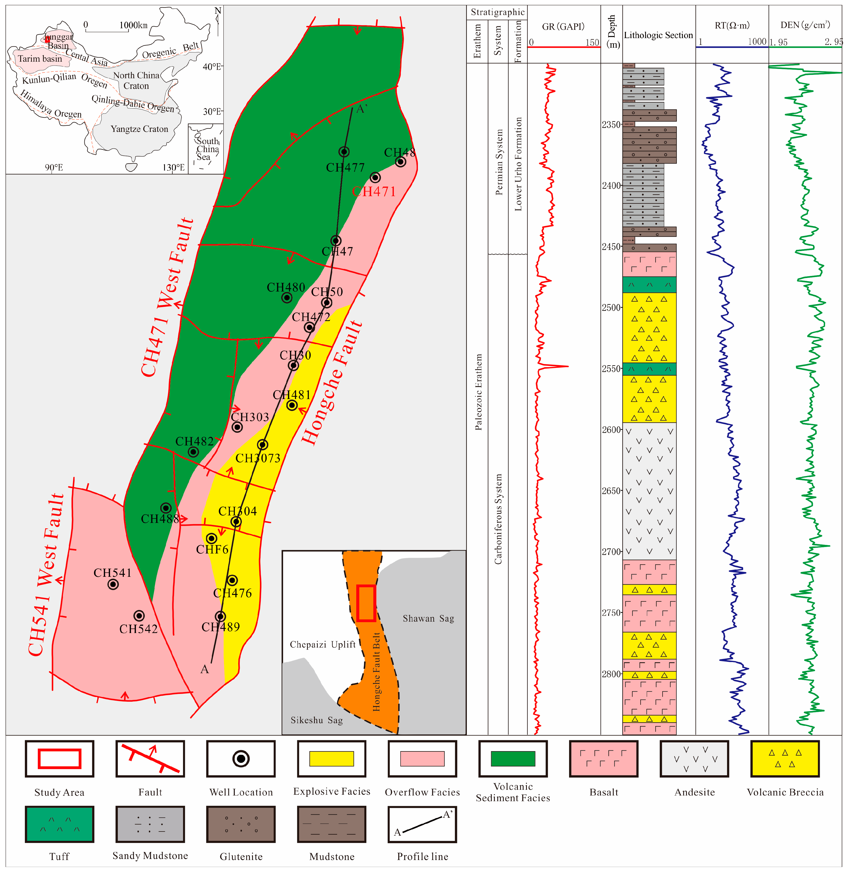
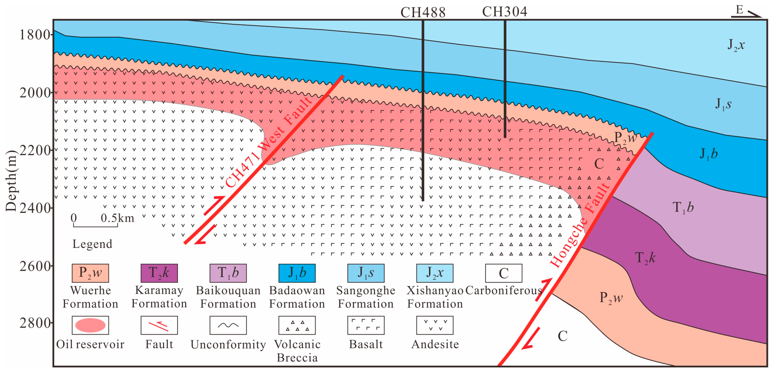
2. Geological Setting

The study area is located in the southern Chepaizi oilfield on the northwest margin of the Junggar Basin and is tectonically located in the upper disk-shaped segment of the Hongche fault belt on the northwest margin of the Junggar Basin [36,37] (Figure 1). The volcanic rocks in the study area were formed by the collision and closure of the Junggar Ocean Basin during the Carboniferous period under the influence of Hercynian movement and are typical continental island arc volcanic rocks at the active edge of converging plates [38,39,40,41]. After the formation of the Carboniferous volcanic mechanism in the study area, the area experienced the superimposed transformation of the Hercynian, Indosinian, Yanshan, and Himalayan tectonic movements, and the resulting internal structure is extremely complex [42,43,44,45]. At the end of the Hercynian movement, volcanic rocks in the study area experienced tectonic inversion from regional stretching to thrust nappe, and the Hongche fault zone began forming (Figure 2). The Indochinese period began to be transformed into a southwest–northeast oblique extrusion deformation, and the Hongche fault zone began to be transformed into a right-lateral strike-slip extrusion and continued to act in the Yanshanian period and Himalayan period [46,47].
Laterally, the Carboniferous system mainly contains two groups of nearly S-N and E-W reverse faults [48]. Among them, the north–south fault is the main fault in the study area, which was formed in the thrust-napping process of the middle Hercynian to late Hercynian. The Indosinian and Yanshan Epochs mainly inherited and formed synsedimentary faults based on the original structure. The overall formation time was early, and the faults cut many horizons over a large scale. The other group of east–west faults was formed in the middle to late Indosinian period. The right-lateral strike-slip fault occurred along the Hongche fault zone, and the thrust fault perpendicular to the main fault was formed under the action of extrusion. The main disconnected beds were Carboniferous beds, with faults with small fault spacing and late formation times that cut through the early north–south faults (Figure 1) [44]. Longitudinally, the Carboniferous strata are dominated by igneous rocks, which are in unconformable contact with the lower Wuerhe Formation (P2w). Influenced by the thrust nappe of the Hongche fault zone (middle Hercynian to late Hercynian), the Carboniferous strata gradually uplifted from east to west and underwent denudation, and a weathering crust formed at the top boundary of the Carboniferous system.

3. Samples and Methods

In this paper, core observation and description are carried out in 17 wells with a total of 250 m and 33 samples. Preparation of 0.03 mm-thick cast thin sheets for more than 30 samples from the research area was performed, and microscopic studies of these thin sections were carried out using LB102 optical microscope produced by Laite Company. At the same time, 50 cast thin slices, 72 fluorescence thin slices, and 140 scanning electron microscopes were collected. Various types of pore spaces were evaluated through tissue observation and thin-section studies of resin-impregnated samples.
Petrophysical analysis was performed on more than 200 porosity samples from 17 wells in the CH471 area to measure the range of porosity and permeability. According to China National Petroleum Industry Standard (SY/T 5830-1993) [49] requirements, the porosity, and permeability were measured using a PoreMaster60 automatic mercury injection instrument. The analyzer measures the porosity of the rock by the mercury injection method. By pressurizing the mercury into the rock sample, the mercury volume change in the different hole grades can be measured when the pressure of the hole is continuously changed, and the porosity can be obtained by comparing the volume of the rock sample.
Many types of information on oil and gas exploration from Xinjiang Oilfield Company, PetroChina, including logging, mud logging, and oil and gas testing, were used to study and evaluate the characteristics of volcanic rock reservoirs.

4. Experimental Results

4.1. Volcanic Reservoir Characteristics of Lithology and Lithofacies

Through observations of more than 200 m of Carboniferous volcanic rock cores and identification of corresponding rock thin sections, combined with a comparative analysis of logging data, the volcanic facies in the study area are mainly divided into volcanic sedimentary facies, overflow facies, and explosive facies. The lithology mainly consists of tuffaceous sandstone, tuff, andesite, basalt, and volcanic breccia. Laterally, the Carboniferous volcanic rocks are distributed in a southwest–northeast strip shape with good continuity and rapidly pinch out from east to west (Figure 1).
The tuff in the study area is mainly cemented by volcanic debris. The interior is mostly composed of debris, crystal pyroclasts, glass shards, flame, and volcanic ash, and the appearance is mostly dark gray or gray-black (Figure 3a). The material in tuffaceous sandstone volcanic rock is lower than that of tuff, and the material is mixed with normal sediments, such as sediment and gravel. Under the microscope, the particle size of the tuff debris is less than 2 mm, and the particles have a tuff structure (Figure 3b). Andesite is a neutral extrusive rock; fresh surfaces are brownish gray; after weathering or alteration, it is generally purple-red, and the cracks in the core are filled by white material (Figure 3c). The andesite is mainly composed of medium feldspar and labradorite, with some dark minerals, and the matrix shows an interweaving structure (Figure 3d). Basalt is a basic extrusive rock. The rock core color is usually dark black or dark green, with pores and almond-shaped pores. The pores are mostly filled with chlorite and calcite in the later stage, affected by weathering or alteration (Figure 3e). Under the microscope, the basalt is composed of basic plagioclase and pyroxene, and it has a porphyritic structure (Figure 3f,g). The volcanic breccia in the area is mainly basaltic andesitic volcanic breccia. The fresh surface of the core is mostly grayish black, with a volcanic breccia structure and block structure. The breccia content is more than 50%, the particle size is more than 1 cm, and some breccia surface pores are developed (Figure 3h). Under the microscope, the matrix is mainly strip-shaped plagioclase, with a small amount of chlorite and pyroxene and a porphyritic structure (Figure 3i).

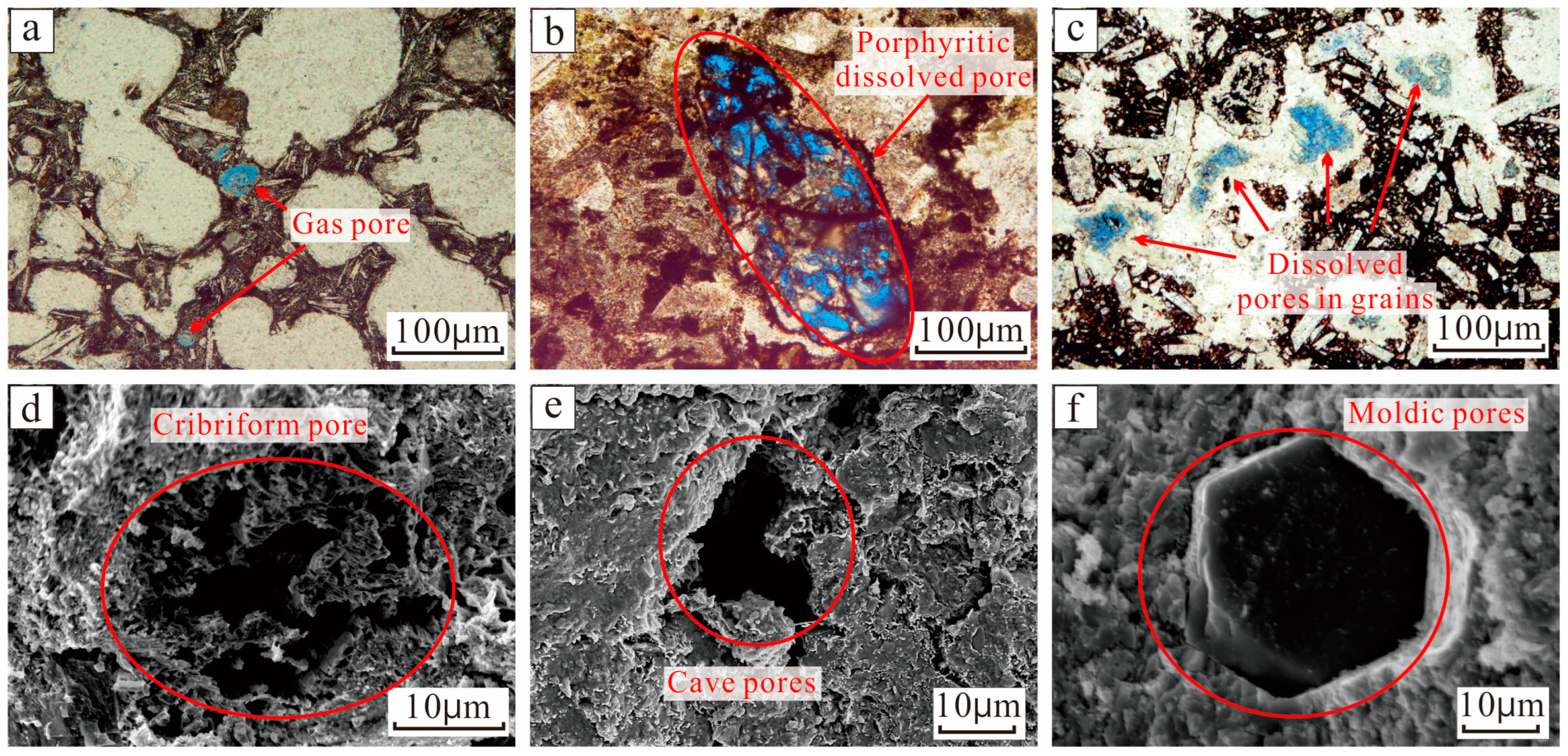
4.2. Volcanic Reservoir Pore Types and Characteristics

Through core observations, thin section identification, and scanning electron microscope observation and analysis, it is suggested that the reservoir space of the Carboniferous volcanic reservoir in the area can be divided mainly into two categories, namely, pore type and fracture type, which can be further subdivided into four categories: primary pore, secondary pore, primary fracture, and secondary fracture [50,51,52,53,54,55].
The main pores of the reservoir in the study area are mainly primary pores (Figure 4a). The upwelling and decompression of molten magma causes a “degassing” effect of volatile components, such as water or carbon dioxide, which erupts to the surface and cools quickly and then is fixed in the rocks to form pores; these pores are developed mostly in the upper parts of lava, such as basalt and andesite [56,57]. The observations under the microscope showed that the stomatal distribution is uneven, the pore shape is mainly round, and some pores have irregular shapes with different sizes. The larger pores are visible to the naked eye at approximately 1 cm, and the smaller pores need to be observed under the microscope. Some pores are filled with calcite, chlorite, and other minerals, forming semifilled pores or amygdules, resulting in poor reservoir storage. The primary pores that developed in the volcanic rocks are mostly isolated, and their connectivity is poor. In the later stage, the transformation of tectonism and weathering dissolution is needed to form effective reservoir space. Secondary pores are dominated by various dissolution pores, mainly pores formed by the complete or partial dissolution of the volcanic rock matrix or soluble minerals in the later stage. The phenocryst dissolved pores, intragranular dissolved pores, and sieve pores are pores formed via hydrothermal dissolution in the later soluble mineral stage (Figure 4b–d). The volcanic matrix’s dissolution forms the Cave pores (Figure 4e). Moldic pores (Figure 4f) are formed through mineral shedding [58].
The proportion of primary fractures in the study area is small, being mainly condensation shrinkage fractures [59]. As a typical rock-forming fracture formed in the process of volcanic rock diagenesis, there are two ways to form condensation shrinkage fractures. One method of formation is the process of magma condensation and crystallization, which forms inside clastic particles (Figure 5a). The other formation method is via the tensile stress caused by the cooling and shrinkage of volcanic rocks, which makes the surface of the rock mass rupture and form cold shrinkage joints (Figure 5b). The secondary fractures mainly include structural fractures and dissolution fractures. Structural fractures are caused by tectonic stress, which has the characteristics of long extension, directionality, and regularity (Figure 5c). Some structural fractures are affected by breccia and develop along the edge of breccia to form intergravel fractures (Figure 5d). A dissolution fracture is based on an original fracture or joint, which is dissolved by dissolution fluid, and dissolution expansion occurs at the edge of the fracture (Figure 5e,f).

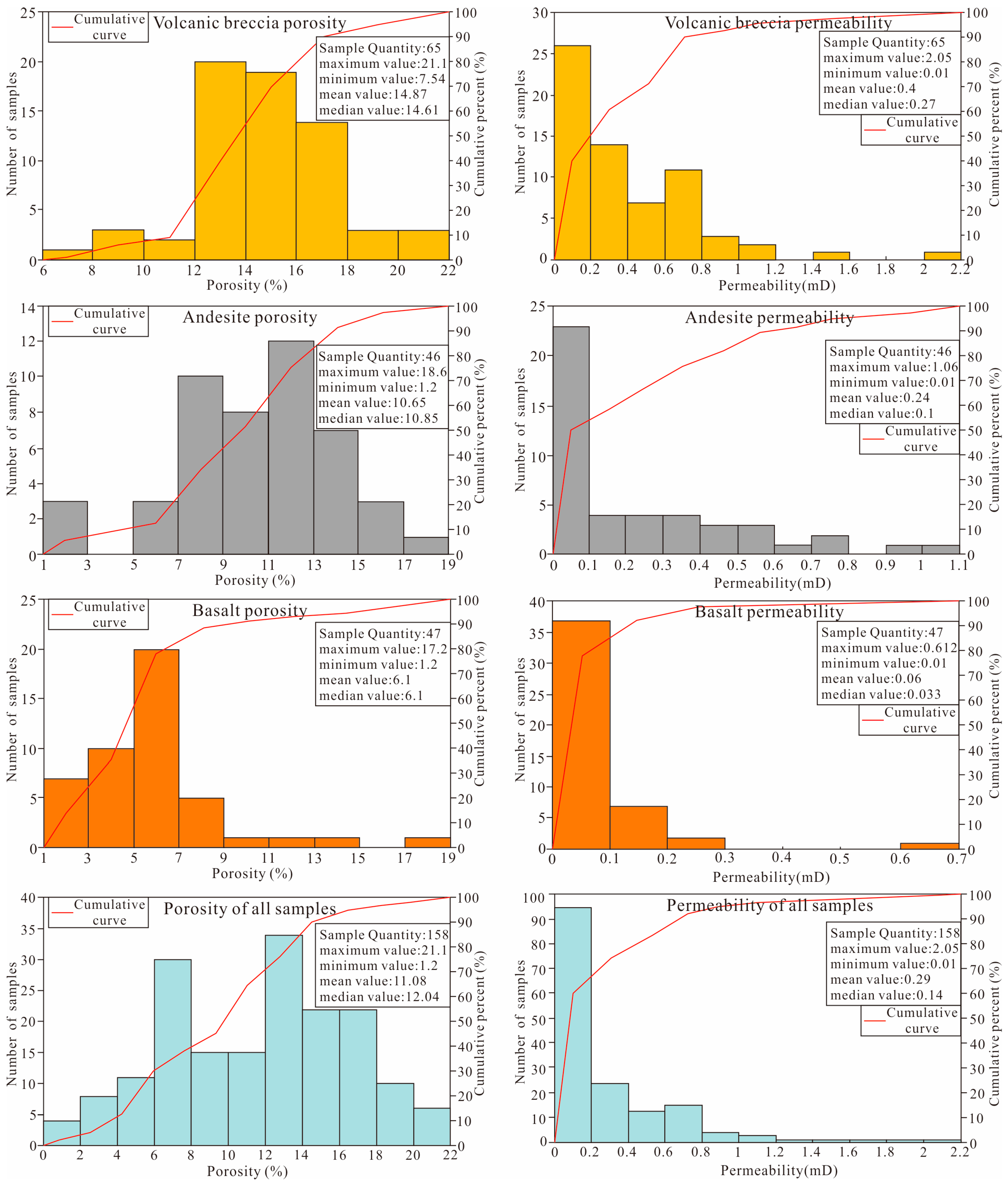
4.3. Reservoir Physical Properties

The experimental results of the porosity and permeability analysis of Carboniferous volcanic rock core samples in the study area show that (Figure 6) the porosity and permeability of volcanic breccia are generally high, the porosity values are between 7.54% and 21.1%, with an average of 14.87%, and the permeability values are between 0.01 mD and 2.05 mD, with an average of 0.4 mD; andesite has the second highest porosity and permeability, with porosity values of 1.2%~18.6% and an average of 10.65%, and permeability values of 0.01 mD~1.06 mD, with an average of 0.24 mD; basalt is the densest, with porosity values of 1.2%~17.2%, and a mean value of 6.1%, permeability values of 0.01 mD~0.612 mD, and a mean value of 0.06 mD.
The overall porosity values of volcanic rocks in the study area are between 1.2% and 21.1%, with an average of 11.08%, and the average permeability values are less than 0.3 mD, which indicates medium-porosity and ultralow-permeability rocks. Because the study area is located on the hanging wall of the Hongche fault zone, the regional structure is complex, the faults and cracks are extremely developed, and the volcanic rock itself is highly heterogeneous, experiments on the porosity and permeability cannot show the improvement in the physical properties of the volcanic rock matrix caused by large cracks. The porosity and permeability of the layers with microcracks, pores, and dissolved pores are much higher than those of the undeveloped layers, which causes the overall experimental results to have a poor correlation with the real porosity and permeability, and the actual porosity and permeability are higher [60,61,62]. The experimental results show that without considering other factors, the volcanic breccia matrix has the best physical properties, followed by andesite, and basalt is the densest.

5. Discussion

Volcanic rocks have strong heterogeneity, and it is impossible to track reservoirs simply by the distribution of the dominant lithology. As the basis of reservoir development, the dominant lithology is not a decisive factor [63,64]. The main body of the study area is located on the hanging wall of the Hongche fault zone. After forming the Carboniferous volcanic rocks, many cracks are generated inside the rock mass under the influence of thrust nappe. At the same time, they are uplifted and subjected to weathering and denudation so that the isolated pores inside the volcanic rocks can be connected, and finally, a high-quality reservoir is formed. The above comprehensive analysis considers the lithology the basis for developing volcanic reservoirs in the area. The later transformation of fractures, weathering and leaching is the key to reservoir formation. Tectonic action controls the development of faults and promotes the occurrence of weathering. The above points are the main factors controlling reservoir development. Based on the above control factors, the control influence range and degree of each factor on the reservoir can be divided, respectively, and the advantage area can be superimposed to track the favorable reservoir.

5.1. Lithology Is the Foundation of Reservoirs

Physical properties experiments show that the volcanic rock matrix has medium-to low-porosity and ultralow-permeability physical properties. Some pores are present in the matrix, but there is a lack of connectivity. The formation of reservoirs is more dependent on later fracturing, weathering, and leaching, but the matrix pores of different lithologies are different, and the later transformation is different and difficult [65]. Among them, the volcanic breccia matrix of the explosive facies has the best physical properties, and internal pores, such as gravel fissures, are conducive to transformation via later weathering and dissolution and fracture development. The physical properties of andesite and basalt are relatively poor, and basalt is denser, but as a basic magmatic rock, basalt is more susceptible to weathering and dissolution. The acidic andesite has a strong anti-weathering ability, and the effect on later transformation is poor. Therefore, volcanic breccia is the best lithology for reservoirs, followed by basalt, and andesite is a poor reservoir lithology.
According to the statistics of 13 single wells with a cumulative production of more than 3000 tons and oil test data in the study area, the cumulative total reservoir thickness is 586 m (Table 1): the thickness of the volcanic breccia reservoir accounts for 63%, that of andesite accounts for 9.5%, and that of basalt accounts for 27.5%; the oil test production values are 192 t/d, 27 t/d, and 103 t/d, respectively; and the statistical results are consistent with the research findings; that is, lithology cannot be used as a decisive factor, but the matrix porosity and permeability are better, and the lithology with poor weathering resistance is more likely to become a reservoir.
According to the results of a single-well volcanic reservoir, the lateral distribution of Carboniferous volcanic reservoirs with different lithologies and lithofacies is reconstructed and analyzed by using Gxplorer software. The distribution of volcanic breccia reservoirs with explosive facies is relatively concentrated, and the thickness is large. This type is mainly located in the eastern part of the study area and is distributed in a north—south strip (Figure 7a). This feature occurs because the explosive facies is mainly developed near the crater. The basalt and andesite reservoirs with the overflow facies are widely distributed laterally, have small thicknesses, are mainly located in the central and western parts of the study area, and are distributed in a north—south strip (Figure 7b).

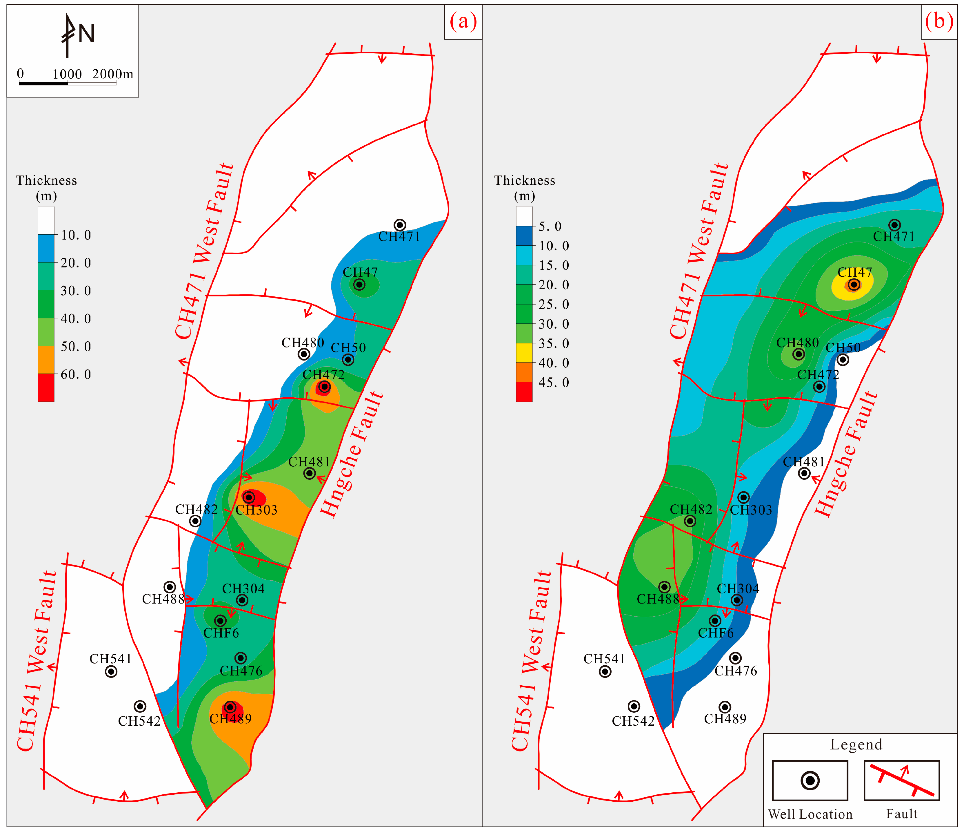
5.2. Fracturing, Weathering, and Leaching Are the Key to Reservoir Formation

The primary pores in the early stage of volcanic rock formation are often isolated and disconnected from each other. The reservoir needs to be reformed through fracturing, weathering, and leaching to improve the connectivity and increase the reservoir space before it can become an effective reservoir.

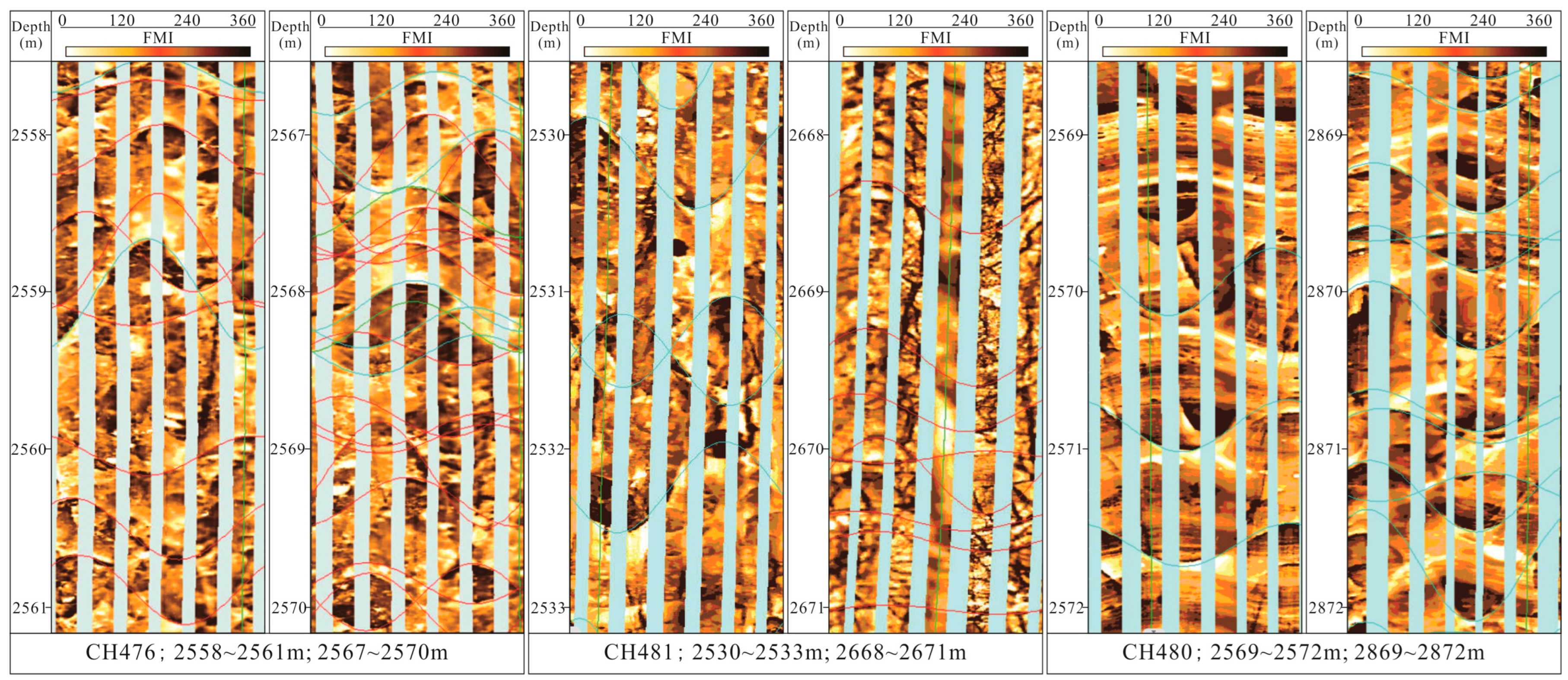
5.2.1. Effect of Fracturing on the Reservoir

The development of fractures is very important for forming volcanic reservoirs [51,66]. The development of fractures not only improves the connectivity and increases the reservoir space but also provides a channel for hydrothermal infiltration of later weathering and leaching, accelerating the weathering of volcanic rocks and forming effective reservoirs. The study area is located on the front edge of the hanging wall of the Hongche fault zone. In the Hercynian period, multiple faults were formed under the influence of thrust nappe tectonic activity, which caused extreme development of the cracks in the Carboniferous volcanic rocks in the area and provided conditions for the formation of reservoirs. In this paper, the influence of fractures on reservoirs is further verified by core observations and imaging logging combined with production data.
A total of more than 200 m of statistics and observations of volcanic rock cores in the study area show that the filling degree of core fractures in the oil layer is low, with unfilled fractures accounting for more than 60%, semifilled fractures accounting for 27%, and fully filled fractures accounting for only 11%. The filling degree of the fractures in the core in the non-oil layer is high, the sum of fully filled and half-filled fractures accounts for nearly 95%, and the unfilled fractures account for only approximately 5% (Figure 8). The effectiveness of the fractures in the volcanic reservoir section is significantly higher than that in the non-oil section.
In the imaging logging data comparison, three high-production Wells CH476, CH481, and CH480 are taken as examples. The first is CH476: the depths of the perforated section are 2558~2561 m, the lithology is volcanic breccia, the fracture density is 2.6 bar/m, the permeability is 4.72 mD, and the oil test output is 1.6 t/d. The depths of the perforated section are 2567~2570 m, the lithology is volcanic breccia, the fracture density is 7 bar/m, the permeability is 13.97 mD, and the test oil production is 6.9 t/d. The second is CH481: the depths of the perforated section are 2530~2533 m, the lithology is volcanic breccia, the fracture density is 1.3 bar/m, the permeability is 1.46 mD, and the oil test output is 14.2 t/d. The depths of the perforated section are 2668~2671 m, the lithology is volcanic breccia, the fracture density is 2.6 bar/m, the permeability is 8.11 mD, and the test oil production is 24.27 t/d. The second is CH480: the depths of the perforated section are 2569~2572 m, the lithology is basalt, the fracture density is 1 bar/m, the permeability is 2.72 mD, and the oil test output is 0.49 t/d. The depths of the perforated section are 2869~2872 m, the lithology is basalt, the fracture density is 3 bar/m, the permeability is 15.25 mD, and the test oil production is 21.13 t/d (Figure 9). In summary, it is concluded that the test oil production is relatively high in the layers with high fracture density.
According to the analysis of the above research results, based on the same lithology in the same single well, the high fracture development density can effectively improve the reservoir permeability and obtain relatively high oil test data, the density and effectiveness of fractures are key factors controlling reservoir development, and the area with dense development of effective fractures is conducive to the development of high-quality reservoirs.

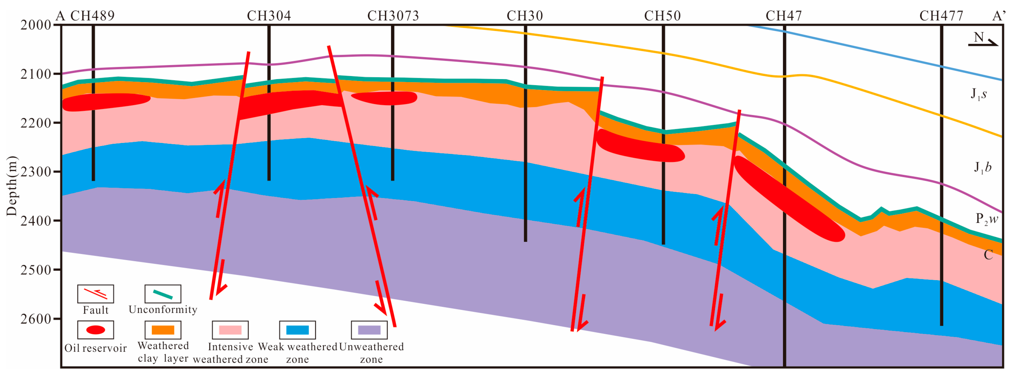
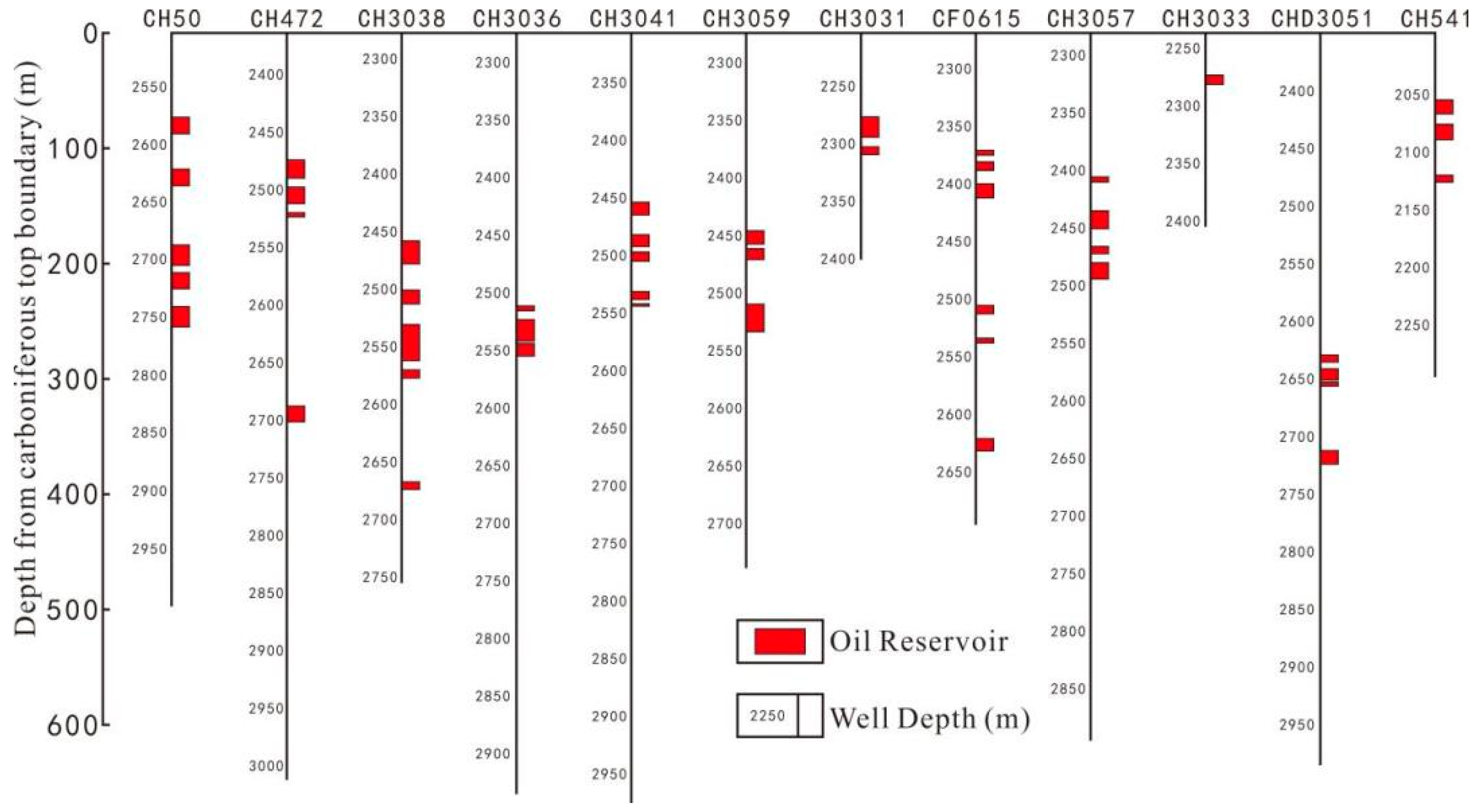
5.2.2. Effect of Weathering and Leaching on Reservoirs

The influence of weathering and leaching on volcanic reservoirs is similar to that of fractures, which mainly improves connectivity and increases reservoir space. The difference is that the influence of weathering and leaching on volcanic reservoirs is vertical and regular [67,68]. The study area is located in the middle section of the hanging wall of the Hongche fault zone. The Carboniferous volcanic rocks in the area were affected by the late Hercynian thrust nappe after formation. After uplift, they were exposed at the surface and affected by weathering and leaching for a long time, forming an ancient weathering crust at the top of the Carboniferous strata.
According to core observations and statistical work, the volcanic rocks have obvious weathering and leaching in the depth range of 200–300 m from the top boundary of the Carboniferous system. This depth difference should be due to the different weathering resistances of different lithologies. Taking well CH48 as an example, at the top boundary of the Carboniferous strata (2631.10 m), the core is the most affected by weathering, and some parts of the core have been broken. However, with increasing distance from the top boundary, the degree of weathering of the core gradually decreases. The core above 100 m (2726.67 m) from the top boundary is still affected by weathering to a certain extent, with obvious development of dissolution pores and fractures. Until the depth reaches more than 250 m (2885.71 m), the core has no obvious weathering (Figure 10).
Based on the above understanding, a map of the longitudinal distribution of the weathering degree in the study area was established (Figure 11). The range within 50 m from the top boundary of the Carboniferous system is part of the weathered clay layer. In this range, the reservoir is blocked by clayization due to excessive weathering. The range of 50~200 m from the top boundary of the Carboniferous strata is a strong weathering zone. The closer to the top of this range, the stronger the weathering is, and the more favorable the formation of high-quality reservoirs. In the range of 200~300 m, the strata are part of the weak weathering zone, the reservoir development is relatively poor, and the reservoir physical properties are general. The unweathered zone greater than 300 m basically does not contain reservoirs.
To further verify the influence of weathering and leaching on the reservoir, the distance between the oil-bearing intervals of 12 wells in the study area and the top boundary of the Carboniferous system is statistically analyzed. The results are as follows (Figure 12). The oil-bearing layers in the study area are mainly concentrated in the range of 50~300 m from the top boundary of the Carboniferous strata, and the cumulative production of some single wells can reach more than 20,000 tons. The analysis shows that the oil-bearing layers are too close to the top surface of the weathering crust (less than 50 m), and the weathering effect is too strong, which causes the layers to be easily blocked by clay and have difficultly forming a reservoir. However, far away (more than 300 m), the weathering effect is weak, the transformation effect is poor, and it is also difficult to form high-quality reservoirs. In the range of 50~300 m, the weathering and leaching effect is not strong enough to destroy the reservoir but can also complete the transformation of the reservoir, thus forming a high-quality reservoir. The strong weathering zone within 50~200 m is the optimal reservoir interval, and the closer to the top, the easier it is to form high-quality reservoirs.

5.3. Tectonic Movement Is the Basis of Volcanic Reservoir Formation

Volcanic reservoirs are different from sedimentary reservoirs. Their formation is inseparable from the influence of tectonic movement. In the long period of geological history after its formation, volcanic rocks experience multiple stages and various forms of superposition due to tectonic movement, which promotes the formation of a large number of structural fractures in volcanic rocks and increases connectivity. The high part of the volcanic rock mass is uplifted via tectonic movement and subjected to weathering and denudation to form a weathering crust, forming many dissolution pores and dissolution fractures in the volcanic rock, further improving the connectivity and increasing the reservoir space.
The Carboniferous volcanic rocks in the study area are located on the hanging wall of the Hongche fault zone. Since their formation, they have been superimposed by a series of tectonic movements, such as the Hercynian, Indosinian, Yanshanian, and Himalayan movements. It is mainly divided into the following three stages: (1) The volcanic rocks in the late Hercynian movement were uplifted and subjected to weathering and denudation under the action of thrust and napper. A large number of fractures occur in the rock mass during the tectonic inversion from tension to extrusion. (2) Under the influence of the Indosinian tectonic movement, the Hongche fault began to have right-lateral strike-slip extrusion movement, accompanied by a large number of fractures, while the weathering and denudation weakened and received deposition again. (3) The Yanshan Stage and Himalayan Stage inherited the original tectonic activity, but the intensity gradually weakened.
The influence of tectonic movement on the reservoir in the area mainly manifests in the following two points. The first point is that the superposition of multistage tectonic movements causes a large number of structural fractures to be formed inside the tight volcanic rocks, which increases the connectivity and provides a channel for the infiltration of the dissolution fluid to promote dissolution. The second point is that the rock mass is uplifted and subjected to weathering and denudation under the influence of the thrust nappe structure, and the weathering crust forms on top of the volcanic rock, which greatly improves the reservoir physical properties of the volcanic rock within a certain range from the weathering crust.

6. Conclusions

(1) The volcanic reservoir lithology in the study area mainly consists of volcanic breccia, andesite, and basalt. Among them, the volcanic breccia matrix has the best physical properties and the largest reservoir thickness, and it is the dominant lithology of reservoir development, followed by basalt. Andesite is the least dominant lithology.
(2) The reservoir space of the Carboniferous volcanic reservoir in the study area is mainly composed of primary pores, secondary structural fractures, and dissolution pores. The primary pores depend on the later transformation of secondary pores to form effective reservoirs.
(3) Due to the uplift of the Carboniferous system in the study area by a thrust nappe, the surface is exposed to weathering and denudation, and the weathering crust is formed at the top. The top weathering crust of the Carboniferous strata is divided into a clay layer, strong weathering layer, weak weathering layer, and unweathered area from top to bottom. The reservoirs with the best physical properties are mainly found in the interval of 50~300 m from the top of the Carboniferous strata.
(4) The formation of Carboniferous volcanic reservoirs in the CH471 well area is controlled by lithological facies, weathering and leaching, fractures, and tectonic action. Vertically, the reservoir is controlled by weathering and leaching within 400 m from the top boundary of the Carboniferous. Laterally, the volcanic reservoir is controlled by the distribution of the dominant lithology and the area of dense fracture development. The fractures mainly develop near the fault zone. Tectonic movement promotes the development of faults and the formation of weathering and leaching.

Author Contributions

Z.C. and Q.Q. are responsible for analyzing the data and writing the manuscript. H.L. is responsible for manuscript and experimental design. J.Z. and J.W. are responsible for data. All authors have read and agreed to the published version of the manuscript.

Funding

The research was supported by: (1) Research Institute of Exploration and Development, Xinjiang Oilfield Company, PetroChina: grant No. 20203006; (2) The key R&D projects of the Deyang Science and Technology Plan: grant No. 2022SZ049.

Data Availability Statement

Since the data in this study are the production data of Xinjiang Oilfield Company and belong to trade secrets, the data are not suitable for wide dissemination, so the selected data are not available.

Acknowledgments

We thank the Research Institute of Exploration and Development staff for their technical support in writing this article.

Conflicts of Interest

Jie Wang is affiliated with Research Institute of Exploration and Development, Xinjiang Oilfield Company, PetroChina, and the other authors declared no potential conflict of interest with respect to the research, authorship, and publication of this article.

References

  1. Schutter, S.R. Occurrences of Hydrocarbons in and around Igneous Rocks; The Geological Society: London, Britain, 2003; Volume 214, pp. 35–68. [Google Scholar] [CrossRef]
  2. Nakata, J.K. Distribution and Petrology of the Anderson-Coyote Reservoir Volcanic Rocks, California; Open-File Report—US Geological Survey, No. 80-1256; United States Department of the Interior Geological Survey: Reston, VA, USA, 1980. [CrossRef]
  3. Sruoga, P.; Rubinstein, N.; Hinterwimmer, G. Porosity and permeability in volcanic rocks: A case study of the Serie Tobifera, South Patgonia, Argentina. J. Volcanol. Geotherm. Res. 2004, 132, 31–43. [Google Scholar] [CrossRef]
  4. Tang, F.H.; Tian, Z.W.; Gao, Y.F.; Dai, X.J. Review of volcanic reservoir geology in China. Earth-Sci. Rev. 2022, 232, 104158. [Google Scholar] [CrossRef]
  5. Magara, K. Volcanic reservoir rocks of northwestern Honshu Island, Japan. Geol. Soc. Lond. Spec. Publ. 2003, 214, 69–81. [Google Scholar] [CrossRef]
  6. Wang, L.; Li, J.H.; Shi, Y.M.; Zhao, Y.; Ma, Y.S. Review and prospect of global volcanic reservoirs. Geol. China 2015, 42, 1610–1620. [Google Scholar] [CrossRef]
  7. Mao, Z.G.; Zhu, R.K.; Luo, J.L.; Wang, J.H.; Du, Z.H.; Su, L.; Zhang, S.M. Reservoir characteristics, formation mechanisms and petroleum exploration potential of volcanic rocks in China. Pet. Sci. 2015, 12, 54–66. [Google Scholar] [CrossRef]
  8. Jiang, H.; Shi, Y.; Zhang, Y.; Fan, Z.; Shi, F.; Kou, Y.; Wang, L. Potential of global volcanics-hosted oil-gas resources. Resour. Ind. 2009, 11, 20–22. [Google Scholar] [CrossRef]
  9. Petford, N.; McCaffrey, K. Hydrocarbons in Crystalline Rocks: An Introduction; The Geological Society: London, Britain, 2003; Volume 214, pp. 1–5. [Google Scholar] [CrossRef]
  10. Zou, C.N.; Zhao, W.Z.; Jia, C.Z.; Zhu, R.K.; Zhang, G.Y.; Zhao, X.; Yuan, X.J. Formation and distribution of volcanic hydrocarbon reservoirs in sedimentary basins of China. Pet. Explor. Dev. 2008, 35, 257–271. [Google Scholar] [CrossRef]
  11. Jiang, F.; Cheng, R.H.; Ruan, B.T.; Lin, B.; Xu, Z.J.; Li, Z.C. Formation mechanism of volcanic reservoirs within a volcanostratigraphic framework: The case of the Wangfu fault depression in the Songliao Basin, China. Mar. Pet. Geol. 2017, 84, 160–178. [Google Scholar] [CrossRef]
  12. Yang, H.; Zhang, Y.; Zou, C.N.; Wen, B.H.; Li, J.Z.; Li, M. Exploration scheme of gas in deep-seated volcanic rocks in Songliao Basin. Pet. Explor. Dev. 2006, 33, 274–281. [Google Scholar] [CrossRef]
  13. Lin, R.J.; Xu, K.D. The discussion of hydrocarbon in Mesozoic volcanic rocks distributed zone in the eastern parts of Zhejiang, Fujian and Guangdong provinces. Acta Pet. Sin. 1995, 16, 23–30. [Google Scholar] [CrossRef]
  14. Lu, B.Q.; Zhang, Y.J.; Wang, H.G.; Zhuang, Y.L. Present and Prospect of Cenozoic/Mesozoic Volcanic Rock Oil and Gas Accumulations in East of China. Offshore Oil 2003, 23, 9–13. [Google Scholar] [CrossRef]
  15. Chen, Z.H.; Liu, W.; Zhang, Y.; Yan, D.T.; Yang, D.S.; Zha, M.; Li, L. Characterization of the paleocrusts of weathered carboniferous volcanics from the Junggar Basin, western China: Significance as gas reservoirs. Mar. Pet. Geol. 2016, 77, 216–234. [Google Scholar] [CrossRef]
  16. Kuang, L.C.; Xue, X.K.; Zou, C.N.; Hou, L.H. Oil accumulation and concentration regularity of volcanic lithostratigraphic oil reservoir: A case from upper-plate Carboniferous of KA-BAI fracture zone, Junggar Basin. Pet. Explor. Dev. 2007, 34, 285–290. [Google Scholar] [CrossRef]
  17. Gao, C.H.; Zhang, J.H.; Jiang, R.F. Fault Plugging History and Hydrocarbon Accumulation of Carboniferous Volcanic Rock in the Northwestern Margin of Junggar Basin. J. Xi’an Shiyou Univ. Nat. Sci. Ed. 2018, 7, 1–7. [Google Scholar] [CrossRef]
  18. Chen, Z.H.; Wang, X.Y.; Wang, X.L.; Zhang, Y.G.; Yang, D.S.; Tang, Y. Characteristics and petroleum origin of the Carboniferous volcanic rock reservoirs in the Shixi Bulge of Junggar Basin, western China. Mar. Pet. Geol. 2017, 80, 517–537. [Google Scholar] [CrossRef]
  19. Zhu, D.P.; Liu, X.W.; Guo, S.B. Reservoir Formation Model and Main Controlling Factors of the Carboniferous Volcanic Reservoir in the Hong-Che Fault Zone, Junggar Basin. Energies 2020, 13, 6114. [Google Scholar] [CrossRef]
  20. Zheng, H.; Sun, X.M.; Zhu, D.F.; Tian, J.X.; Wang, P.J.; Zhang, X.Q. Characteristics and factors controlling reservoir space in the Cretaceous volcanic rocks of the Hailar Basin, NE China. Mar. Pet. Geol. 2018, 91, 749–763. [Google Scholar] [CrossRef]
  21. Sruoga, P.; Rubinstein, N. Processes controlling porosity and permeability in volcanic reservoirs from the Austral and Neuquén basins, Argentina. AAPG Bull. 2007, 91, 115–129. [Google Scholar] [CrossRef]
  22. Feng, Z.H.; Yin, C.H.; Liu, J.J.; Zhu, Y.K.; Lu, J.M.; Li, J.H. Formation mechanism of in-situ volcanic reservoirs in eastern China: A case study from Xushen gasfield in Songliao Basin. Sci. China-Earth Sci. 2014, 57, 2998–3014. [Google Scholar] [CrossRef]
  23. Tang, Y.J.; Chen, F.K.; Peng, P. Characteristics of volcanic rocks in Chinese basins and their relationship with oil-gas reservoir forming process. Acta Petrol. Sin. 2010, 26, 185–194. [Google Scholar] [CrossRef]
  24. Chen, H.Q.; Hu, Y.L.; Jin, J.Q.; Ran, Q.Q.; Yan, L. Fine Stratigraphic Division of Volcanic Reservoir by Uniting of Well Data and Seismic Data-Taking Volcanic Reservoir of Member One of Yingcheng Formation in Xudong Area of Songliao Basin for an Example. J. Earth Sci. 2014, 25, 337–347. [Google Scholar] [CrossRef]
  25. Zou, C.N.; Zhu, R.K.; Zhao, W.Z.; Jia, C.Z.; Zhang, G.Y.; Yuan, X.J.; Zhao, X.; Wen, B.H. Geologic Characteristics of Volcanic Hydrocarbon Reservoirs and Exploration Directions in China. Acta Geol. Sin.-Engl. Ed. 2010, 84, 194–205. [Google Scholar] [CrossRef]
  26. Sun, H.T.; Zhong, D.K.; Zhan, W.J. Reservoir characteristics in the Cretaceous volcanic rocks of Songliao Basin, China: A case of dynamics and evolution of the volcano-porosity and diagenesis. Energy Explor. Exploit. 2019, 37, 607–625. [Google Scholar] [CrossRef]
  27. Du, S.; Shan, X.L.; Yi, J.; Li, J.Y. Controlling factors of high-quality volcanic reservoirs of Yingcheng Formation in the Songnan gas field. J. Cent. South Univ. 2018, 25, 892–902. [Google Scholar] [CrossRef]
  28. Li, X.L.; Song, M.S.; Lin, H.X.; Zhang, K.H.; Shi, H.G.; Zhang, Y.J.; Hou, D.J. Characteristics of Carboniferous volcanic reservoirs in the Chun-feng Oilfield of the Junggar basin, China. Arab. J. Geosci. 2019, 12, 500. [Google Scholar] [CrossRef]
  29. Sun, X.M.; Cao, S.Y.; Pan, X.; Hou, X.Y.; Gao, H.; Li, J.B. Characteristics and prediction of weathered volcanic rock reservoirs: A case study of Carboniferous rocks in Zhongguai paleouplift of Junggar Basin, China. Interpret.-A J. Subsurf. Charact. 2018, 6, T431–T447. [Google Scholar] [CrossRef]
  30. Fan, C.H.; Li, H.; Qin, Q.R.; Shang, L.; Yuan, Y.F.; Li, Z. Formation mechanisms and distribution of weathered volcanic reservoirs: A case study of the carboniferous volcanic rocks in Northwest Junggar Basin, China. Energy Sci. Eng. 2020, 8, 2841–2858. [Google Scholar] [CrossRef]
  31. Li, H.; Tang, H.M.; Qin, Q.R.; Fan, C.H.; Han, S.; Yang, C.; Zhong, C. Reservoir characteristics and hydrocarbon accumulation of Carboniferous volcanic weathered crust of Zhongguai high area in the western Junggar Basin, China. J. Cent. South Univ. 2020, 8, 2841–2858. [Google Scholar] [CrossRef]
  32. Zhang, K.L.; Wang, Z.L.; Jiang, Y.Q.; Wang, A.G.; Xiang, B.L.; Zhou, N.; Wang, Y. Effects of weathering and fracturing on the physical properties of different types of volcanic rock: Implications for oil reservoirs of the Zhongguai relief, Junggar Basin, NW China. J. Pet. Sci. Eng. 2020, 193, 107351. [Google Scholar] [CrossRef]
  33. Tian, M.; Xu, H.M.; Cai, J.; Wang, J.; Wang, Z.Z. Artificial neural network assisted prediction of dissolution spatial distribution in the volcanic weathered crust: A case study from Chepaizi Bulge of Junggar Basin, northwestern China. Mar. Pet. Geol. 2019, 110, 928–940. [Google Scholar] [CrossRef]
  34. Zhou, L.; Zhou, K.; Wang, G. Distribution features and main controlling factors of volcanic buried hill reservoirs in carboniferous basement of Junggar Basin. Arab. J. Geosci. 2021, 13, 1297. [Google Scholar] [CrossRef]
  35. Ma, S.W.; Luo, J.L.; He, X.Y.; Xu, X.L.; Dai, J.J. The influence of fracture development on quality and distribution of volcanic reservoirs: A case study from the carboniferous volcanic reservoirs in the Xiquan area, eastern Junggar Basin. Arab. J. Geosci. 2019, 12, 110. [Google Scholar] [CrossRef]
  36. Zhou, Y.M. The Gravitational and Magnetic Field Research of Carboniferous Volcanic Rocks in Western-Central Junggar Basin. Ph.D. Thesis, Nanjing University, Nanjing, China, 2018. [Google Scholar]
  37. Liang, Y.S. Geological Structure, Formation and Evolution of Chepaizi Uplift in Western Junggar Basin. Ph.D. Thesis, China University of Geosciences, Beijing, China, 2019. [Google Scholar]
  38. Wang, J.; Chen, J.; Chen, R.B.; Liu, X.J.; Liu, J.; Lian, L.X.; Ma, C. Forming environment of Carboniferous volcanic rocks and its influence mechanism on reservoir performance in the eastern Junggar Basin. Nat. Gas Geosci. 2022, 33, 1785–1797. [Google Scholar]
  39. Jiao, X.Q.; Zhang, G.L.; Niu, H.P.; Wang, S.Z. Genesis of Carboniferous volcanic rocks in northeastern Junggar Basin: New insights into the Junggar Ocean closure. Earth Sci. Front. 2022, 29, 385–402. [Google Scholar] [CrossRef]
  40. Yiming, A.; Bian, B.L.; Liu, L.S.; Chen, H.L.; Shan, X.L.; Li, A. Types and Eruption Patterns of the Carboniferous Volcanic Edifices in the Shixi Area, Junggar Basin. Front. Earth Sci. 2022, 10, 906782. [Google Scholar] [CrossRef]
  41. Mao, L.X.; Chang, X.C.; Xu, Y.D.; Shi, B.B.; Gao, D.K. Geochemical characterization and possible hydrocarbon contribution of the Carboniferous interval natively developed in the Chepaizi Uplift of Junggar Basin, northwestern China. Energy Explor. Exploit. 2020, 38, 654–681. [Google Scholar] [CrossRef]
  42. He, D.F.; Yi, C.; Du, S.K.; Shi, X.; Ma, H.S. Characteristics of structural segmentation of foreland thrust belts—A case study of the fault belts in the northwestern margin of Junggar Basin. Earth Sci. Front. 2004, 11, 91–101. [Google Scholar]
  43. Meng, J.F.; Guo, Z.J.; Fang, S.H. A new insight into the thrust structures at the northwestern margin of Junggar Basin. Earth Sci. Front. 2009, 35, 55–67. [Google Scholar] [CrossRef]
  44. Yu, Y.L.; Wang, X.; Rao, G.; Wang, R.F. Mesozoic reactivated transpressional structures and multi-stage tectonic deformation along the Hong-Che fault zone in the northwestern Junggar Basin, NW China. Tectonophysics 2016, 679, 156–168. [Google Scholar] [CrossRef]
  45. Sui, F.G. Tectonic Evolution and Its Relationship with Hydrocarbon Accumulation in the Northwest Margin of Junggar Basin. Acta Geol. Sin. 2015, 89, 779–793. [Google Scholar] [CrossRef]
  46. Yu, Y.L. Mesozoic Strike-slip Structure and Tectonic Evolution of Hong-Che Fault Zone in the Northwest margin of Junggar Basin, XinJiang, China. Ph.D. Thesis, Zhejiang University, Hangzhou, China, 2016. [Google Scholar]
  47. Ji, Y.L.; Zhou, Y.; Kuang, J.; Wan, L.; Zhang, R.; Lu, C.H. The formation and evolution of Chepaizi-Mosuowan paleo-uplift and its control on the distributions of sedimentary facies in the Junggar Basin. Sci. China-Earth Sci. 2010, 53, 818–831. [Google Scholar] [CrossRef]
  48. Yao, W.J.; Dang, Y.F.; Zhang, S.C.; Zhi, D.M.; Xing, C.Z.; Shui, J.A. Formation of Carboniferous Reservoir in Hongche Fault Belt, Northwestern Margin of Junggar Basin. Nat. Gas Geosci. 2010, 21, 917–923. [Google Scholar] [CrossRef]
  49. SY/T 5830-1993; Description Method of Volcanic Rock Reservoir. Oil and Gas Industry Standards of the People’s Republic of China: Beijing, China, 1993.
  50. Tang, F.H.; Wang, P.J.; Bian, W.H.; Huang, Y.L.; Gao, Y.F.; Dai, X.J. Review of volcanic reservoir geology. Acta Pet. Sin. 2020, 41, 1744–1773. [Google Scholar] [CrossRef]
  51. Li, H.; Tang, H.M.; Qin, Q.R.; Zhou, J.L.; Qin, Z.J.; Fan, C.H.; Su, P.D.; Wang, Q.; Zhong, C. Characteristics, formation periods and genetic mechanisms of tectonic fractures in the tight gas sandstones reservoir: A case study of Xujiahe Formation in YB area, Sichuan Basin, China. J. Pet. Sci. Eng. 2019, 178, 723–735. [Google Scholar] [CrossRef]
  52. Wang, J.; Wang, X.L. Seepage characteristic and fracture development of protected seam caused by mining protecting strata. J. Min. Strat. Control Eng. 2021, 3, 033511. [Google Scholar] [CrossRef]
  53. Li, J.; Li, H.; Yang, C.; Ren, X.H.; Li, Y.D. Geological characteristics of deep shale gas and their effects on shale fracability in the Wufeng–Longmaxi Formations of the southern Sichuan Basin, China. Lithosphere 2023, 2023, 4936993. [Google Scholar] [CrossRef]
  54. Shan, S.C.; Wu, Y.Z.; Fu, Y.K.; Zhou, P.H. Shear mechanical properties of anchored rock mass under impact load. J. Min. Strat. Control Eng. 2021, 3, 043034. [Google Scholar] [CrossRef]
  55. Li, H.; Wang, Q.; Qin, Q.R.; Ge, X.Y. Characteristics of natural fractures in an ultradeep marine carbonate gas reservoir and their impact on the reservoir: A case study of the Maokou Formation of the JLS Structure in the Sichuan Basin, China. Energy Fuels 2021, 35, 13098–13108. [Google Scholar] [CrossRef]
  56. Puffer, J.H.; Laskowich, C. Volcanic diapirs in the Orange Mountain flood basalt: New Jersey, USA. J. Volcanol. Geotherm. Res. 2012, 237, 1–9. [Google Scholar] [CrossRef]
  57. Nabawy, B.S.; Wassif, N.A. Effect of the mineralogical composition on the petrophysical behavior of the amygdaloidal and vesicular basalt of Wadi Wizr, Eastern Desert, Egypt. J. Afr. Earth Sci. 2017, 134, 613–625. [Google Scholar] [CrossRef]
  58. Huang, Q.F.; Dou, Q.F.; Sun, Y.F. Characterization of Pore Structure Variation and Permeability Heterogeneity in Carbonate Rocks Using MICP and Sonic Logs: Puguang Gas Field, China. Petrophysics 2018, 58, 576–591. [Google Scholar]
  59. Ren, Z.W.; Jin, C.S. Reservoir space feature of the volcanic rocks in the area of Well Wa 609, Liaohe sag. Pet. Explor. Dev. 1999, 26, 54–56. [Google Scholar] [CrossRef]
  60. Li, H.; Tang, H.M.; Qin, Q.R.; Wang, Q.; Zhong, C. Effectiveness evaluation of natural fractures in Xujiahe Formation of Yuanba area, Sichuan basin, China. Arab. J. Geosci. 2019, 12, 194. [Google Scholar] [CrossRef]
  61. Wang, S.L.; Li, H.; Lin, L.F.; Yin, S. Development characteristics and finite element simulation of fractures in tight oil sandstone reservoirs of Yanchang Formation in western Ordos Basin. Front. Earth Sci. 2022, 9, 823855. [Google Scholar] [CrossRef]
  62. Li, J.J.; Qin, Q.R.; Li, H.; Wan, Y.F. Numerical simulation of the stress field and fault sealing of complex fault combinations in Changning area, southern Sichuan Basin, China. Energy Sci. Eng. 2022, 10, 278–291. [Google Scholar] [CrossRef]
  63. Ndiaye, M.; Ngom, P.M.; Gorin, G.; Villeneuve, M.; Sartori, M.; Medou, J. A new interpretation of the deep-part of Senegal-Mauritanian Basin in the Diourbel-Thies area by integrating seismic, magnetic, gravimetric and borehole data: Implication for petroleum exploration. J. Afr. Earth Sci. 2016, 121, 330–341. [Google Scholar] [CrossRef]
  64. Villeneuve, M.; Theveniaut, H.; Ndiaye, P.M.; Retière, S. Re-assessment of the northern Guinean “Koubia-Lessere unconformity” (KLU): Consequences on the geological correlations throughout West Africa. Comptes Rendus Geosci. 2014, 346, 262–272. [Google Scholar] [CrossRef]
  65. He, S.; Qin, Q.R.; Li, H.; Zhao, S.X. Geological characteristics of deep shale gas in the Silurian Longmaxi Formation in the southern Sichuan Basin, China. Front. Earth Sci. 2022, 9, 818543. [Google Scholar] [CrossRef]
  66. Liu, J.W.; Zhou, G.L.; Wu, N. Weakening effect of artificial fracture morphology on the tensile strength and energy accumulation of coal. J. Min. Strat. Control Eng. 2022, 4, 053011. [Google Scholar] [CrossRef]
  67. Villeneuve, M.; Wazi, N.; Kalikone, C.; Gärtner, A. A review of the G4 “tin granites” and associated mineral occurrences in the Kivu Belt (Eastern Democratic Republic of the Congo) and their relationships with the last Kibaran tectono-thermal events. Minerals 2022, 12, 737. [Google Scholar] [CrossRef]
  68. Zhang, Z.H.; Yu, H.G.; Chen, H.Y.; Du, S.K.; Li, C. Quantitative characterization of fracture-pore distribution and effects on production capacity of weathered volcanic crust reservoirs: Insights from volcanic gas reservoirs of the Dixi area, Junggar Basin, Western China. Mar. Pet. Geol. 2022, 140, 105651. [Google Scholar] [CrossRef]
Figure 1. Regional tectonic map and Carboniferous strata histogram of the study area.
Minerals 13 01455 g001
Figure 2. Schematic diagram of E-W strike section in the study area.
Minerals 13 01455 g002
Figure 3. Lithological characteristics of Carboniferous volcanic rocks. (a) Tuff, CH545, 2097.84–2098.3 m; (b) Tuff structure and microfractures, CH545, 2097.84 m; (c) Andesite, CH47, 2770.97–2771.15 m; (d) Andesite with interwoven structure with visible medium feldspar, CH47, 2770.97 m. (e) Basalt with visible stomatal development, CH471, 2630.59–2630.72 m. (f) Half-filling fractures and oil spots can be seen in basalt, CH471, 2630.59 m. (g) Basalt, Porphyritic structure, CH471, 2633.75 m. (h) Some breccia surface pores are developed, CH472, 2627.35–2627.69 m. (i) The basaltic andesitic breccia has breccia and interweaving structures, CH472, 2627.35 m.
Minerals 13 01455 g003
Figure 4. Pore types of volcanic reservoirs. (a) Gas pore of basalt, CH541, 2079.05 m. (b) Porphyritic dissolved pore, CH541, 2055.89 m. (c) Dissolved pores in grains, CHF061, 2546.55 m. (d) Cribriform pore, CH541, 2055.89 m. (e) Cave pore, CH542, 2090.86 m. (f) Moldic pore, CH541, 2057.31 m.
Minerals 13 01455 g004
Figure 5. Fracture types of volcanic reservoir. (a) Microfracture and condensation shrinkage fractures, CH30, 2287.08 m. (b) Condensation shrinkage fractures and tension fractures, CH471, 2625.09–2625.38 m. (c) Structural fractures, CH472, 2956.78 m. (d) Intergravel fractures, CH48, 3165.22–3165.41 m. (e) Dissolution fractures, CH48, 2726.67–2726.97 m. (f) Half-filled dissolution fractures, CHF6, 2506.11 m.
Minerals 13 01455 g005
Figure 6. Volcanic rock porosity and permeability distribution histograms.
Minerals 13 01455 g006
Figure 7. The distribution map of reservoir plane thickness in the study area. (a) Plane thickness distribution diagram of explosive facies volcanic breccia reservoir; (b) plane thickness distribution diagram of overflow facies basalt and andesite reservoir.
Minerals 13 01455 g007
Figure 8. Core fracture filling degree distribution histograms. (a) Histogram of distribution of oil layer core filling degree; (b) histogram of distribution of non-oil layer core filling degree.
Minerals 13 01455 g008
Figure 9. CH476, CH481, and CH480 imaging logging figure.
Minerals 13 01455 g009
Figure 10. Core photo of well CH48.
Minerals 13 01455 g010
Figure 11. The longitudinal distribution map of weathering degree in the study area.
Minerals 13 01455 g011
Figure 12. The depth of oil-bearing interval from the top boundary of Carboniferous in the study area.
Minerals 13 01455 g012
Table 1. Statistical table of lithologic reservoir thickness and oil test results.
WellVolcanic Breccia Reservoir (m)Volcanic Breccia Oil Test
(t/Day)
Andesite Reservoir (m)Andesite Oil Test
(t/Day)
Basalt Reservoir (m)Basalt Oil Test
(t/Day)
CH47100104.452410.69
CH4726831.4500144.01
CH47623100000
CH480004.52.9228.518.21
CH4814738.470000
CH48200002926.26
CH48800003018.71
CH4896414.720000
CH473925.9442.120.07500
CH501813.860000
CHF63821.0900143.89
CH3036418.66001117.58
CH3042718.020094.3
Sum388192.2156.627.445159.5103.65
Disclaimer/Publisher’s Note: The statements, opinions and data contained in all publications are solely those of the individual author(s) and contributor(s) and not of MDPI and/or the editor(s). MDPI and/or the editor(s) disclaim responsibility for any injury to people or property resulting from any ideas, methods, instructions or products referred to in the content.

