The Use of Heavy Minerals in the Investigation of Barrier-Lagoon Coasts Development in Dapeng Peninsula, China


School of Geography, South China Normal University, Guangzhou 510631, China
*
Author to whom correspondence should be addressed.
Minerals 2019, 9(6), 347; https://doi.org/10.3390/min9060347
Submission received: 30 April 2019
/
Revised: 20 May 2019
/
Accepted: 3 June 2019
/
Published: 5 June 2019
(This article belongs to the Special Issue Chemical-Physical Properties of Minerals and Minerogenesis in Supergene Environment)
Abstract
:Typical barrier-lagoon systems are developed at Dongchong and Xichong on the southern coast of the Dapeng Peninsula of Guangdong, China. This paper studies the evolution of the barrier coasts of the peninsula, using the examples of the Dongchong and Xichong Bays. The Holocene stratigraphic records from borehole drilling on the coast of Dongchong and Xichong show that lagoon sediments are overlaid with beach deposits, indicating that the barriers migrated landward and climbed over the lagoon sediments when the shoreface retreated during the Holocene transgression, reaching the present positions after 7–8 ka BP. Heavy mineral analysis in this paper shows that: (1) the ancient beach sediments of the two bays have the same heavy mineral assemblages, which are different from those of modern beaches; (2) the present beaches of the two bays have different heavy mineral assemblages, even they are located less than 3000 m from each other on the same coast. This supports the hypothesis that the barriers originally came from the inner shelves during the Holocene transgression, but draws a new conclusion that the source of the beach sediments changed to inland rivers over the last thousand years because of a lack of sediment source from the sea floor.
1. Introduction
Coastal barriers and barrier islands fringe about one-eighth of the world’s coastlines [1]. For more than a century, the origin of barriers and barrier islands has been debated [2,3,4]. Emergent shoals, submergent bars and spit progradation of offshore bars were some early hypotheses [5]. There is no common agreement on their origin, as no single mode of origin seems to explain the observed occurrence and distribution of the world’s barrier coasts, although some modifications and elaborations have been made to each theory in light of the growing body of data [1,6]. It is now widely acknowledged that instead of being solely the products of interglacial sea-level high stands, barriers also existed at lower sea levels and moved landward during the Holocene transgression [5]. As the barriers moved landward, sediment transfers can take place through three primary mechanisms: (1) transfers through the tidal inlets into the lagoon system; (2) overwash of sediments onto the back barrier and into the lagoon; and (3) aeolian sediment transport, directly over the foredune crest onto the lee slope of the barriers and beyond [7]. However, due to variations in regional conditions, especially sediment supply, the growth of the barrier coasts was also different in the world after the Holocene transgression maximum [1,6,8].
Barriers exist in virtually any part of the world on nearly any coastal type [6]. From north to south, barriers, including barrier spit coasts, are well developed on the coasts of China [9,10,11,12,13,14,15,16,17,18,19]. The formation characteristics of the barrier-lagoon coast in Shandong, Hebei, Guangdong, Hong Kong and Hainan in China have been studied [9,10,11,12,13,14,15,16,17,18,19]. Most studies believe that the sediment supply for the barriers in these areas is derived from in situ coastal erosion or inshore rivers, and the barrier itself is mainly formed by coastal sediment movement [9,10,11,12,13,14,15]. Few studies have dealt with the theory of Holocene shoreface translation in the barrier coast evolutions in these areas. Notably, Li et al. [16], Li [17,18] and Dai et al. [19] deduced that the barrier-lagoon systems on the rocky and indented coasts of the western and eastern Guangdong, China, originated from shoreface translation when sea levels rose during the Holocene transgression, based on the following reasons: (1) No mainland beaches formed on the mainland side coast of modern lagoons, while ancient lagoon sediments, the back-barrier deposits, are overlaid with barrier sands; (2) the present coastal sediment supply conditions, including the amount of sediment generated by the direct wave erosion of the coastal bedrock and the grain size of the stream sediments, do not match with the large size of the barriers in South China, which are generally from several kilometers to 20 kilometers long and 2–5 kilometers wide [17]. The Dapeng Peninsula is located along the South China coast, projecting into the South China Sea between Dapeng Bay and Daya Bay on its eastern and western sides, respectively (Figure 1). The barrier-lagoon systems are well developed in the Xichong and Dongchong Bays on the southern coast of the peninsula. Huang et al. [20] suggested that no sea-level highstands existed in the Mid-Late Holocene period, because they found that the beachrock outcrop occurring near the southern end of the present beach face at Xichong can be submerged by sea water during local high tide period with a 14C age of 2170 ± 85 a BP. Lu et al. [21] also obtained a 14C age of 2080 ± 95 a BP from the beachrock in the same section of Xichong Beach. However, the outcrop of the same beachrock was found by Zhang et al. [22] about 30 years later, at a level of 2.08 m higher than the local mean high level (MHW) and 1.34 m higher than the local mean higher high water (MHHW), while the local mean tidal range is not more than 1m [23], indicating a possible higher sea level in the Holocene period. Using thermoluminescence (TL) dating technique, Lu et al. [21] showed that the coastal dune ridges at the top of the Xichong barrier were younger, i.e., shoreward from 2.7 to 1.4 ka BP. Zhang et al. [22] discovered that the sand from streams is the main sedimentary source for the modern beaches of Dongchong and Xichong Bays, based on the analysis of heavy minerals in the sediments of the modern beaches and inland rivers that flow into the bays. However, the sediment source of modern beaches can only reflect the current conditions of coastal dynamics. It is not yet known if the sediment from the barrier-lagoon coasts has come from the inland rivers since the Holocene transgression, or if it came firstly from the continental shelves, and then from inland rivers.
So far, no study has been involved in the evolution of the barrier-lagoon coasts of the peninsula during the Holocene lowstand events. The aim of our study is to establish a conceptual model of Holocene evolution of the barrier–lagoon systems of the Dapeng Peninsula, using the data of borehole strata and heavy minerals in present and ancient deposits at Dongchong and Xichong. The findings of the study give a reference guide for existing coastal studies, which lack sufficient information on coastal responses during the Holocene sea level changes on the coasts of the peninsula and, furthermore, provide evidence to support the validity of the hypothesis of shoreface translation, which played an important role in coastal development in China.
2. Study Area
Dongchong Bay and Xichong Bay are the two largest bays in the Dapeng Peninsula. The two bays are situated on the southern margin of the peninsula facing the South China Sea, and is characterized by embracing a sand barrier with rocky headlands on both sides (Figure 1). The Xichong barrier is about 3 km long with a lagoon behind and three inland streams. The Xichong River, the Danshuichong River and the Nanmenchong River flow into the lagoon with outlets in the middle and on both sides of the barrier, respectively (Figure 1). The Xichong barrier consists of four ridges that are formed parallel to the shoreline with surmounting dunes [20,21] that can be easily identified in the field nowadays [24]. The Dongchong barrier, which is less than 1 km in length with a lagoon behind, is located next to Xichong Bay on the same coast, and the distance between them is no more than 3000 m (Figure 1). An inland stream (the Dongchong River) flows into the lagoon, and the outlet of the stream is located at the western end of the barrier (Figure 1). Most of the lagoon areas behind the barriers of the two bays were artificially filled as cultivated lands and modified as aquaculture ponds (Figure 1).
The Dapeng Peninsula has a subtropical monsoon climate with an average annual temperature of 22 °C and an annual rainfall of about 2280 mm, 80% of which occurs in the period from April to September. Easterly winds prevail throughout the year and constantly blow from the southeast in summer and the northeast in winter. September is the most active month for tropical cyclones and typhoons, producing abundant rain fall [22]. In the sea of the Dapeng Bay, west of the peninsula, the annual maximum wave height is 2 m, and the annual mean wave height is only 0.34 m. Waves from the south are predominant, occupying about 19.23% of the year. Higher waves occur in the period from July to September due to tropical cyclones. The waves within the Daya Bay, east of the peninsula, are generally 1.0–1.5 m in height, and the highest waves occur in October in an easterly direction [23]. The tide on the peninsula is an irregular semidiurnal one. In Daya Bay, the average tidal range is less than 1 m and the average maximum tidal range is about 2.3–2.7 m, while on the coast of Dapeng Bay, the average maximum tidal range is about 2.22–2.51 m and the average tidal range is about 0.91–0.93 m [23].
The bedrock around Xichong Bay is composed of Mesozoic granitic rocks and Paleozoic sedimentary rocks [25]. Before reaching the western side of Xichong Bay, the Xichong River flows across an area where the Upper Jurassic medium-grained porphyritic biotite granite and Lower Cretaceous biotite (monzonitic) granite are widely exposed [22,25]. The rocks that form the headlands on both sides of Xichong Bay are Devonian sedimentary [25]. The Dongchong River begins in an area composed of Mesozoic granites and Devonian sedimentary rocks, and then cuts through an area occupied by Cretaceous and Jurassic volcanic rocks, known as Qiniang Mountain volcanic system, before entering Dongchong Bay [22,25].
3. Materials and Methods
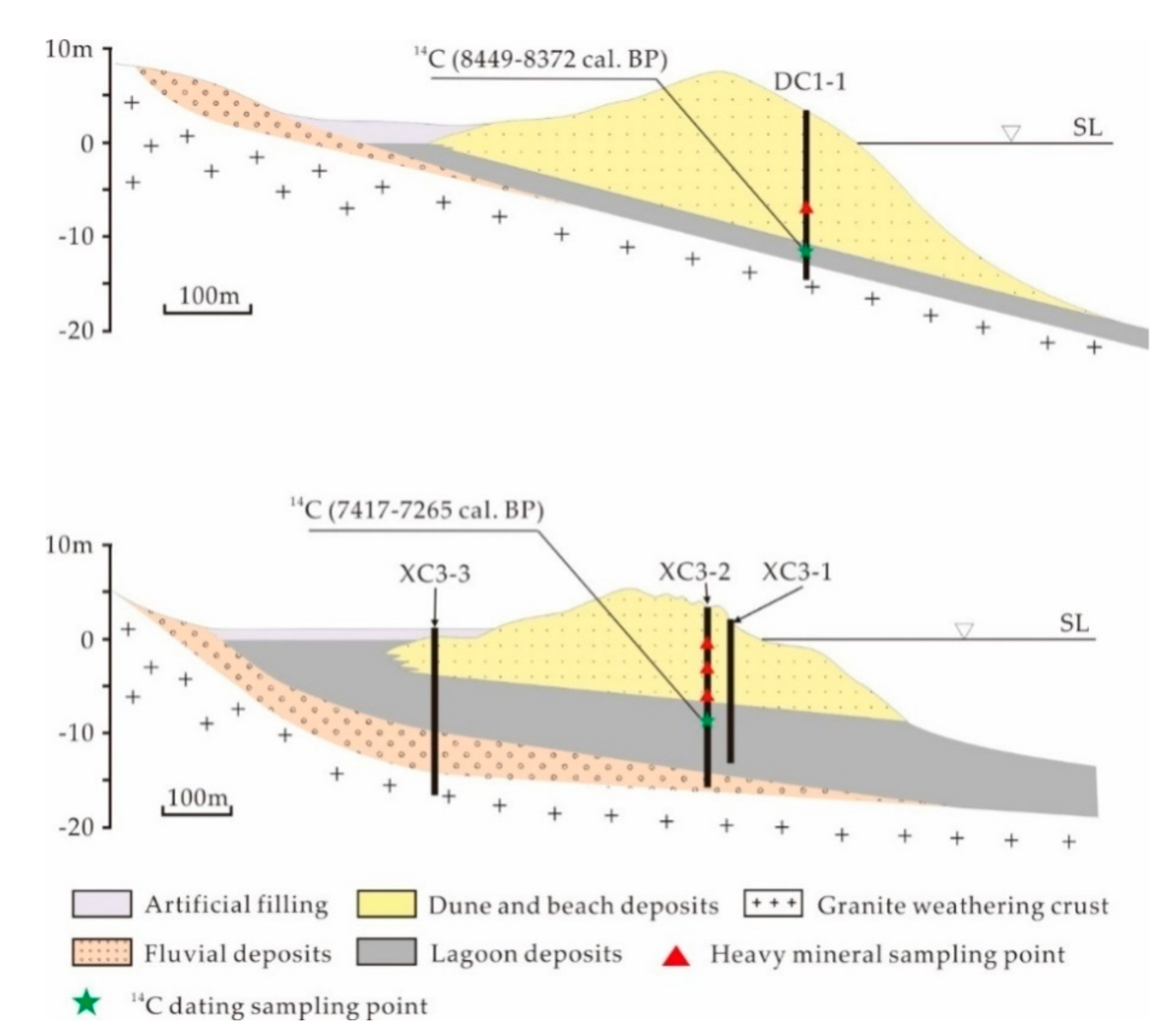
Three boreholes, XC3-1 through XC3-2 and XC3-3, were drilled in the sand barrier and the modern lagoon of Xichong Bay, and DC1-1, in the barrier of Dongchong Bay in 2016. XC3-1 was drilled at the back side of the modern beach, XC3-2 in the lowlands behind the first dune ridge of the barrier and XC3-3 in the modern dry lagoon that has been artificially modified into cultivated land. DC1-1 was drilled at top of the barrier. Figure 2 shows the localities of the cores and the related strata profiles. The borehole depths of DC1-1, XC3-1, XC3-2 and XC3-3 are 19, 16.4, 19 and 18m, respectively. The top elevations of the cores, DC1-1, XC3-1, XC3-2 and XC3-3, measured with real-time kinematic (RTK), are 4.8, 3.17, 4.25 and 2.06m, respectively.
The sedimentary facies of the boreholes were identified based on the color, lithology and borehole locations in the field, as well as on the grain size and the organic matter (OM) and calcium carbonate (CaCO3) contents, which were measured in the laboratory. The core samples for these measurements were taken at 2 cm intervals in lagoon deposits, which are black silt and mud, and 10 cm intervals in sand-sized sediments, representing eolian, beach and river deposits. The samples were used to calculate grain size and OM and CaCO3 contents. The grain size was measured using a Mastersizer 2000 particle size analyzer (Malvern Panalytical, Shanghai, China). The grain-size parameters (mean particle size (Mz)) were calculated by means of the graphical method [26], the CaCO3 content was determined by the gasometric method [27] and the OM content was measured using potassium dichromate oxidation-ferrous sulfate titrimetry [28].
Samples of ancient beach sediments were taken from core XC3-2 at depths of 3.7, 6.5 and 9.5m, respectively, and from core DC1-1 at a depth of 11m for heavy mineral analysis (Figure 2). The work of heavy mineral separation and identification includes dry weighting, crushing, washing, sieving, and magnetic and heavy liquid separation of the samples. The work was carried out in the Rock Test Center of Geological Surveying Institute of Hebei Province, Langfang, China. A more detailed description of the procedures can be found in Ren and Zhu [29].
Based on the results of the identification, the percentage of particles of each mineral species was calculated. The mineral species were further divided into eight groups according to their similarities. Then, the main group of each sample was used to form a mineral assemblage, representing the mineral features of the sample. In this study, a comparison of heavy mineral assemblages was made between the old beach sediments in the boreholes and the deposits taken from the modern rivers and beaches of the two bays. The work of identifying the heavy mineral assemblages of modern beaches and their river sources in Xichong and Dongchong Bays was carried out by Zhang et al. [22].
Two samples of AMS carbon-14 (14C) age were determined and taken from the lagoon deposits at depths of 12.18m for XC3-2, and 15.5m for DC1-1, respectively. The location of the samples is shown in Figure 2. These samples were dated in the Beta Analytic Testing Laboratory in the United States.
4. Results
4.1. Stratigraphic
The stratum profiles of Xichong and Dongchong coasts are similar. The sequence of the strata from the top to the bottom of the boreholes is as follows: coastal dunes, beach deposits, lagoon sediments, river sediments (which cannot be found in the core of Dongchong), and granite weathering crusts (Figure 3). Coastal dunes and beach sediments are generally medium and coarse sands, and have a low content of OM and high content of CaCO3 due to large amounts of shell debris. Lagoon sediments are usually silt and mud, which are grey or dark black in color, with a high content of OM and lower content of CaCO3. River sediments are usually coarse sand, containing well-rounded gravel and pebbles with lower content of CaCO3. The weathering crust is indicated by a layer of greenish-yellow or reddish-yellow clay, representing the granite weathering profile of Zone I [30]. The depths of the lagoon sedimentary layers in the boreholes are 14.5–17.9m for DC1-1, 10–16.4m for XC3-1, 10.7–17.4m for XC3-2, and 5–11m for XC3-3, respectively.
4.2. Chronology
The radiocarbon ages of the lagoon deposits of the boreholes of DC1-1and XC3-2 are 8449–8372 calibrated BP and 7417–7265 calibrated BP, respectively. The ages are calibrated by Beta Laboratory. The results of the radiocarbon dating are shown in Table 1, Figure 2. Also, the combined topography and facies cross-sections are shown in Figure 3.
4.3. Heavy Mineral Species of Ancient Beach Sands in Xichong Bay and Dongchong Bay
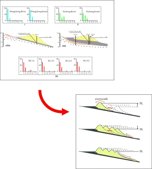
A total of 11 heavy minerals species were found in the sediments of Dongchong and Xichong ancient beaches; their mineral characteristics are described in Table 2. The heavy mineral parentages of the sediment samples are listed in Table 3. Zhang et al. [22] have divided the heavy mineral species of the beaches and streams of Xichong and Dongchong into eight groups based on their similarities: opaque minerals, stable minerals, platy minerals, epidote group minerals, amphibole group minerals, pyroxene group minerals, authigenic minerals and metamorphic minerals. In order to compare the minerals of older beaches with modern sediments (beaches and rivers), the heavy mineral species of the ancient sediments are also divided into the same eight groups, according to Zhang et al. [22]. For comparison, the heavy mineral parentages and eight mineral groups of the present sediments of Xichong River (XC-R), Xichong Beach (XC-B), Dongchong River (DC-R) and Dongchong Beach (DC-B) at Dongchong and Xichong, derived from Zhang et al. [22], are also listed in Table 3 and Table 4, respectively.
The heavy mineral species of the three samples of XC-3.7, XC-6.5 and XC-9.5 in the Xichong ancient beach are the same as those of DC-11 in the old beach of Dongchong (Table 3 and Table 4). Opaque minerals are the most common minerals in the ancient beaches of Dongchong and Xichong, with a content of more than 59%, including iron mineral, ilmenite, leucoxene and anatase, of which the ilmenite content is the most abundant, with a content of more than 20% (Table 3). Stable minerals include zircon, garnet, tourmaline and rutile. The content of zircon is significantly higher than that of other minerals, which is above 10% and is followed by tourmaline (Table 3). Each of the mineral groups of amphiboles, epidotes and metamorphs in the older beaches contains only one kind of mineral. They are hornblende, green epidote and kyanite, respectively, whose content is less than 10% (Table 3).
5. Discussion
5.1. Stratigraphic and Chronology Evidence of the Barrier-Lagoon Coasts
A coastal lagoon is a body of water that has been cut off from the sea by a barrier or barrier island, and the sediments of a lagoon are carried by rivers, by tidal currents entering from the sea and by winds blowing sand from bordering coastal dunes [1]. The lagoon environment exists only in the protection of barriers. As a sedimentary element behind the barrier, lagoon sediments should be deposited on the landward side of, but not beneath, the barrier.
However, the stratigraphic sequences in the boreholes of XC3-2 at Xichong and DC1-1 at Dongchong show that the lagoon sediments that should be deposited in back-barrier situations are overlaid by barrier sand bodies (Figure 3). Such a stratigraphic sequence in the present environments provides evidence for the pre-existence of lagoons, as well as barriers at low sea levels, indicating that the barriers migrated landward across lagoon and swamp deposits through the postglacial marine transgression and moved to their present-day controlled locations, rather than by in situ accretion when sea level was stabilized [5]. The lagoon deposits in XC3-2 and DC1-1 yielded radiocarbon ages around 7000–8000 years BP, indicating that the areas of the cores were back barrier environments at that time, and that afterwards, the barrier moved up landward over the lagoon as the sea level continued to rise, reaching the present position on the Holocene sea level high stand.
5.2. Heavy Minerals and Sedimentary Sources for the Barrier-Lagoon Coasts
The heavy minerals from the ancient beaches of Xichong and Dongchong have the same mineral assemblages (see Assemblage type III in Figure 4). This supports the conclusion drawn from the stratigraphic data that barriers existed when sea level was lower on the continental shelf, rather than being formed by in situ accretion on the Holocene sea level high stand. As a result of this process, the beaches (or barriers) formed at the two bays, which were very close on the same coast, had the same sediment source. However, the heavy mineral compositions of the ancient beaches are obviously different from those of the modern beaches and rivers at Xichong and Dongchong. The percentages of heavy mineral groups of the modern streams and beaches at Dongchong and Xichong are listed in Table 3 and Table 4; they consist of different mineral assemblages (see Assemblage types II and III in Figure 4) [22].
As shown in Table 3, Pyrite, despite the fact that it comprises less than 1% of the total material, is contained in modern sediments both at Dongchong and Xichong, but cannot be found in the ancient beaches of the two bays. At Xichong, chlorite, whose contents are 26.36% and 15.42%, respectively, is an important mineral both in the modern beach and in the stream, but could not be found in the ancient beach. Similarly, modern sediments have high contents of iron minerals, i.e., 51.50% for the Dongchong River and 15.74% for the Dongchong Beach, respectively, but the content of the same mineral is less than 3% in the ancient beach of Dongchong (Table 3). This suggests that the sediments of the present beaches are no longer from the continental shelf. The work of Zhang et al. [22] has shown that the types of heavy minerals in the sediments of the present beach at Xichong are different from those at Dongchong, even though the two beaches are separated by less than 3000 m. The significant differences in the heavy mineral assemblages between the old and the present sediments provide evidence of a shift in the sediment sources for the barriers from the sea floor to inland rivers. The different types of heavy mineral assemblages in the old and present sediments of each bay are illustrated by Figure 4.
5.3. The Evolution of the Barrier-Lagoon Coasts
Sea level change is a fundamental driver of long-term coastal evolution and shoreline migration [31]. Cessation of barrier transgression and barrier stabilization is a function of sand supply in relation to relative sea level (RSL), and there is no common agreement on the Holocene relative higher sea level on the coasts of Dapeng Peninsula [20,22]. The reasons for the existence of the Holocene higher sea level are as follows: the local mean tidal range is less than 1 m and the local mean maximum tidal range (2.48 m) is similar to or a little bit smaller than the thickness (2.85 m) of the beachrock outcrops exposed in the Xichong beach, and the lowest level of the outcrop is only 0.27 m below the mean water level; however, the maximum height of the outcrop occurring on the beach is 2.31 m higher than the local mean water level (MWL), more than 2.08 m higher than MHW and 1.34 m higher than MHHW [22]. This indicates that RSL remained higher than the present sea level at least before 2170 years BP, and then declined to the present level. The four ridges of the Xichong barrier with surmounting dunes, which are younger shoreward, from 2700 to 1400 a BP [21], suggest that the barrier prograded shoreward. Favorable conditions for barrier progradation occur when sea levels rise slowly, stabilize or fall [5]. Thus, it can be concluded that the landward migration of the barrier ceases when the Holocene marine transgression comes to an end, and then with the decline of the sea level after the mid-Holocene high stand, the barrier subsequently widened by progradation, with successive parallel ridges being added on the seaward side.
At this stage, the sediment source for the progradation still came from the inner shelf erosion due to the decline in sea-level [5,32]. Inland stream sediments cannot be the main source for the barrier at this stage, because all the streams in the Dapeng Peninsula are so short that they could not provide enough sediment to maintain the large sand bodies of the barrier that prograded shoreward. Longshore drifts were truncated by the headlands on both sides of the embayment, and the eroded material from the cliffs of the headland did not contribute much to the formation of the barrier, which was verified by heavy mineral analysis [22].
However, this study shows that there was a shift in the sediment source of the barrier from the inner shelf to the inland streams. As previously mentioned, the sediments provided by the streams cannot maintain the sandy bay barrier and, as a result, the barrier beach will suffer from erosion, which is distinguished by the beachrock outcrops occurring on Xichong Beach at a level lower than local MW about 30 years ago [20], but more than 2.31 m higher nowadays [22], indicating that the beach is now being cut back by erosion. The reduction of sediment supply from the sea floor occurs on the coast undergoing a marine transgression and long-term erosion, either because the RSL is rising or due to a negative imbalance in the sediment budget [5]. Much of the sediments from the inner continent shelf are now stored in the form of beach and dune systems, and as a result, the sediment supply to many barrier systems is now much lower than it was several hundreds to thousands of years ago [7]. Then, the ceased growth of the barriers due to a lack of sediment supply from the sea floor may be the cause for the shift from progradation to erosion. The cessation of the shoreward drift of beach sediment could also be due to the diminished production of washed shell deposits from the sea floor, or to increased growth of sea grasses or other marine vegetation due to ecological changes [1]. Ecological changes in China in recent decades and rising sea levels due to global warming could also be contributing factors.
The modal evolution can be summarized in three stages as follows (Figure 5):
(I) The pre-existing barrier-lagoons on the inner shelf when the sea level was lower, migrating landward across lagoon/swamp deposits as a result of recurrent overwashing by storm waves (controlled by shoreface transition) during the postglacial marine transgression and moving to their present-day locations when the Holocene marine transgression came to an end.
(II) When the sea level decreased after the highstand events, the barrier widened shoreward with successive parallel ridges being added to the seaward side; the sediment sources for the progradation originated from the erosion of the sediments on the inner shelf.
(III) The barrier ceased growing in the last 1000–2000 years and was eroded, and the sediment source was replaced by stream deposits due to the reduced supply of sea floor sediment.
6. Conclusions
Based on the stratigraphic records and heavy mineral analysis, it can be concluded that pre-existing barriers on the inner shelf migrated landward and rose over the lagoon sediments when the shoreface retreated during the Holocene transgression. At the time in which the sea level dropped after the previous sea level highstand, the barrier widened shoreward with successive parallel ridges being added to the seaward side. The barrier ceased to grow in the last 1000–2000 years and was eroded, and the sediment source was replaced by stream deposits due to the reduced supply of sea floor sediment.
Author Contributions
W.W. designed research and interpreted results; J.F. performed the experiments and analyzed the data; The manuscript was written by J.F. and corrected by W.W.
Funding
This work was supported by Natural Science Foundation of China (allotment grant number 41571002).
Acknowledgments
We would like to give a special thanks to the post graduate students of School of Geography science, South China Normal University, Zhang Ke, Zheng Wanli, Huang Qianwei, Wu Song and Sheng Li for their assistance in laboratory works. We also thank three anonymous reviews for their helpful comments and suggestions.
Conflicts of Interest
The authors declare no conflict of interest.
References
- Bird, E. Coastal Geomorphology: An Introduction, 2nd ed.; John Wiley & Sons: Chichester, UK, 2008; pp. 201–222. [Google Scholar]
- Hoyt, J.H. Influence of island migration on barrier island sedimentation. Geol. Soc. Am. Bull. 1967, 78, 77–86. [Google Scholar] [CrossRef]
- Schwartz, M.L. Barrier Island; Dowden, Hutchinson & Ross: Stroudsburg, PA, USA, 1973. [Google Scholar]
- Otvos, E.G. Barrier island evolution and history of migration, north-central Gulf Coast. In Barrier Island; Leatherman, S.P., Ed.; Academic Press: New York, NY, USA, 1979; pp. 291–319. [Google Scholar]
- Roy, P.S.; Cowell, P.J.; Ferland, M.A.; Thom, B.G. Wave-dominated coasts. In Coastal Evolution: Late Quaternary Shoreline Morphodynamics; Carter, R.W.G., Woodroffe, C.D., Eds.; Cambridge University Press: Cambridge, UK, 1994; pp. 121–186. [Google Scholar]
- Davis, J.R.A. Barrier island systems-a geologic overview. In Geology of Holocene Barrier Island Systems; Davis, J.R.A., Ed.; Springer: Berlin/Heidelberg, Germany, 1994; pp. 1–46. [Google Scholar]
- Davidson-Arnott, R. Introduction to Coastal Processes and Geomorphology; Cambridge University Press: Cambridge, UK, 2010. [Google Scholar]
- Bird, E. Coastline changes. In Encyclopedia of Coastal Science; Schwartz, M., Ed.; Springer: Dordrecht, The Netherlands, 2005; pp. 319–323. [Google Scholar]
- Li, F. Evolvement of little lagoon on Baishakou coast and formation barrier-lagoon coast. Mar. Sci. 1983, 7, 12–18. [Google Scholar]
- Li, C.X.; Chen, G. Vertical sequences and sedimentary environments of the Taoyuan barrier-lagoon area, Rongcheng, Shandong Province. Mar. Sci. Bull. 1984, 3, 38–44. [Google Scholar]
- Chen, G.; Li, C.X. Sedimentary characteristics and developmental process of the Qilihai barrier-lagoon system, Hebei Province. J. Oceanogr. HuanghaiBohai Seas. 1984, 2, 39–48. [Google Scholar]
- Zhang, Z.Y.; Ju, L.J.; Feng, X.L.; Peng, X.M. Barrier lagoon sedimentation and evolution in Sanshan Island-Diaolongzui area, Laizhou, Shandong. Mar. Geol. Quat. Geol. 1994, 14, 43–52. [Google Scholar]
- Li, X.A.; Yin, Y.; Jia, P.H.; Gao, X.Y. The evolution of sedimentary environment of Lingshui barrier-lagoon coast since the Late Pleistocene, Southeastern Hainan Island. Quat. Sci. 2016, 36, 44–56. [Google Scholar]
- Wang, W. The sediment source for the bay barrier on the Hong Kong Coasts-A case study in Pui O Bay in Lantau Island, Hong Kong. Sci. Geogr. Sin. 2000, 20, 45–50. [Google Scholar]
- Gao, S.; Zhou, L.; Li, G.C.; Wang, D.D.; Yang, Y.; Dai, C.; Han, Z.C.; Wang, H.; Tu, J.Y.; Yang, B.M. Processes and sedimentary records for Holocene coastal environmental changes, Hainan Island: An overview. Quat. Sci. 2016, 36, 1–17. [Google Scholar]
- Li, C.C.; Luo, X.L.; Zhang, Z.Y.; Chen, Y.T. Formation and evolution of the barrier-lagoon systems in Shuidong, Western Guangdong. Chin. Sci. Bull. 1986, 31, 1579–1582. [Google Scholar]
- Li, C.C. Geomorphic characteristics of the harbor-coast in South China. Acta Geogr. Sin. 1986, 41, 311–320. [Google Scholar]
- Li, C.C. Several problems of sedimentary coastal geomorphology and shoreface translation, China. Mar. Sci. Bull. 1987, 69–73. [Google Scholar]
- Dai, Z.J.; Han, L.; Shi, W.Y. Analyses of dynamics and evolution on bar-lagoon coast in Houjiang Bay, east Guangdong. J. Oceanogr. Taiwan Strait 2001, 20, 142–146. [Google Scholar]
- Huang, Z.G.; Li, P.R. Shenzhen Geomorphology; Guangdong Science and Technology Press: Guangzhou, China, 1983; pp. 64–105. [Google Scholar]
- Lu, Y.C.; Zhang, J.Z.; Xie, J. Thermoluminescence dating of coarse-grain quartz of sand bars along the Dapeng Bay in Shenzhen, Guangdong Province, China. Acta Oceanol. Sin. 1991, 13, 531–539. [Google Scholar]
- Zhang, S.; Wang, W.; Huang, R.H.; Xu, L.B. The sedimentary source, planform stability and shore normal morphological change of the Xichong beach on the southern coast of the Dapeng Peninsula of Shenzhen, Guangdong Province, China. Acta Oceanol. Sin. 2015, 34, 76–89. [Google Scholar] [CrossRef]
- Huang, F.; Ye, C.C. Ocean Hydrology of Islands off the Coast of Guangdong; Guangdong Science and Technology Press: Guangzhou, China, 1995; pp. 10–77. [Google Scholar]
- Zhang, S.; Sun, X.L.; Wang, W.; Huang, R.H.; Lai, Y.X.; Liu, Y.; Zhu, L.; Song, T.; Jin, X.X.; Zhang, H.H.; et al. Features of Coastal Landforms in Dapeng Peninsula of Shenzhen, China. Trop. Geogr. 2013, 33, 647–658. [Google Scholar]
- Writing Group for Shenzhen Geology. Shenzhen Geology; Geological Publishing House: Beijing, China, 2009; pp. 53–97. [Google Scholar]
- Folk, P.L.; Ward, W.D. Brazos River bar [Texas]: A study in the significance of grain size parameters. J. Sediment. Res. 1957, 27, 3–26. [Google Scholar] [CrossRef]
- Bien, G.S. Chemical Analysis Methods; University of California: Berkeley, CA, USA, 1952; pp. 52–58. [Google Scholar]
- State Oceanic Administration of People’s Republic of China. GB 17378.5-2007; Standards Press of China: Beijing, China, 2007; pp. 50–52.
- Ren, Y.X.; Zhu, B.H. Heavy Placer Mineral Separation and Identification; China University of Geosciences Press: Wuhan, China, 1987; pp. 17–36. [Google Scholar]
- Ruxton, B.P.; Berry, L. Weathering of granite and associated erosional features in Hong Kong. Geol. Soc. Am. Bull. 1957, 68, 1263–1292. [Google Scholar] [CrossRef]
- Kinsela, M.A.; Cowell, P.J. Controls of shoreface response to sea level change. In The Proceedings of the Coastal Sediments 2015; Wang, P., Rosati, J.D., Cheng, J., Eds.; World Scientific Publishing: Singapore, 2015. [Google Scholar]
- Bruun, P. Coastal Erosion and the Development of Beach Profiles; Beach Erosion Board Technical Memorandum, No. 44; US Army Engineer Waterways Experiment Station: Vicksburg, MS, USA, 1954. [Google Scholar]
Figure 1.
Map of study area. Red circles are the locations of cores at Dongchong and Xichong.

Figure 2.
The strata profiles with portholes at Xichong and Dongchong. The red triangle is the sampling point of heavy minerals. The green star is the sampling point of 14C dating; calibrated age is in parenthesis.
Figure 2.
The strata profiles with portholes at Xichong and Dongchong. The red triangle is the sampling point of heavy minerals. The green star is the sampling point of 14C dating; calibrated age is in parenthesis.

Figure 3.
The description of strata profiles in Xichong Bay and Dongchong Bay. Red star denotes 14C dating.
Figure 3.
The description of strata profiles in Xichong Bay and Dongchong Bay. Red star denotes 14C dating.

Figure 4.
Three different heavy mineral assemblages in the sediments of ancient beaches, modern beaches and streams at Dongchong and Xichong. 1—Opaque minerals; 2—stable minerals; 3—platy minerals; 4—amphibole group minerals; 5—epidote group minerals; 6—authigenous minerals; 7—pyroxene group minerals; 8—metamorphic minerals; I—assemblage of present sediments at Dongchong; II—assemblage of present sediments at Xichong; III—assemblage of ancient beach sands at Dongchong and Xichong.

Figure 5.
Three stages in the evolution of the barrier-lagoon coasts of the Dapeng Peninsula.


Table 1.
14C data and calibrations of ancient beach sediments of Xichong and Dongchong.
| Sample Code Number | Elevation (m) | Laboratory Number | Analysis Material | 14C Age (BP) | Calendar Calibrated Age (cal. BP) | Medium (BP) |
|---|---|---|---|---|---|---|
| XC3-2-12.18 | −7.9 | Beta-522996 | Mud | 6390 ± 30 | 7417–7265 | 7341 |
| DC1-1-15.5 | −10.7 | Beta-523000 | Mud | 7619 ± 30 | 8449–8372 | 8311 |
Table 2.
The description of heavy mineral characteristics.
| Mineral Species | Characteristic Description |
|---|---|
| Zircon | The light rose is the main color, the deep rose is the second, the rounded column is mainly granular, the prism is the second, and the individual is the long column. Most of the crystal surface is slightly rough, the transparency is low, a shiny glass surface, and a few crystal surfaces are smooth and transparent. It is diamond shiny, and some crystals contain solid and gas-liquid inclusions. |
| Rutile | Reddish brown, black brown, irregular granular, plate column, greasy luster–semi-metallic luster, translucent–opaque. |
| Anatase | Brownish yellow, yellowish green, blue-green, blue-black, irregular granular, double-cone, greasy luster, opaque. |
| Leucoxene | Yellow wax, off-white, wax red, irregular granular, waxy luster–earthy luster, opaque. |
| Kyanite | White, light pink, granular, Plate column, frosted glass luster, translucent. |
| Garnet | Light and dark pink, persimmon yellow, irregular granular, glass luster, transparent. |
| Epidote | Emerald green, irregular granular, greasy luster, translucent. |
| Hornblende | Dark green, plate, granular, waxy luster, translucent. |
| Tourmaline | Tea brown, black brown, blue, irregular granular, elliptical granular, columnar, glassy, transparent. |
| Iron mineral | Maroon, irregular granular, semi-metallic luster, opaque. |
| Ilmenite | Iron black, irregular granular, elliptical granular, plate, semi-metallic luster, opaque. |
Table 3.
Heavy minerals and percentages of sediment particles at Xichong and Dongchong.
| Mineral Group | Mineral Species | XC-3.7 | XC-6.5 | XC-9.5 | DC-11 | XC-R | XC-B | DC-R | DC-B |
|---|---|---|---|---|---|---|---|---|---|
| Opaque minerals (%) | iron mineral | 2.75 | 8.49 | 2.87 | 2.83 | 34.95 | 8.69 | 51.50 | 15.74 |
| ilmenite | 31.35 | 21.86 | 31.34 | 31.6 | 8.98 | 12.91 | 3.97 | 24.86 | |
| leucoxene | 19.22 | 16.97 | 16.51 | 13.68 | 1.56 | 18.03 | 4.34 | 16.29 | |
| anatase | 6.18 | 12.34 | 10.29 | 11.08 | 1.99 | 8.24 | 14.72 | 12.81 | |
| chromite | 0 | 0 | 0 | 0 | 1.70 | 0 | 0 | 0 | |
| Stable minerals (%) | zircon | 16.93 | 11.31 | 13.16 | 13.91 | 14.09 | 26.83 | 13.32 | 11.40 |
| garnet | 5.49 | 3.85 | 6.46 | 3.54 | 1.74 | 2.49 | 0.98 | 7.60 | |
| tourmaline | 7.55 | 7.45 | 8.85 | 5.66 | 0.52 | 0.70 | 0 | 2.71 | |
| rutile | 2.29 | 4.62 | 2.87 | 2.12 | 1.12 | 2.44 | 0.73 | 1.95 | |
| sphene | 0 | 0 | 0 | 0 | 0.34 | 0.36 | 1.22 | 0 | |
| kietyoite | 0 | 0 | 0 | 0 | 0.13 | 0 | 0.06 | 0 | |
| corundum | 0 | 0 | 0 | 0 | 1.39 | 0 | 0.31 | 0.54 | |
| monazite | 0 | 0 | 0 | 0 | 0 | 0.25 | 0 | 1.30 | |
| Platy minerals (%) | chlorite | 0 | 0 | 0 | 0 | 26.36 | 15.42 | 0 | 0 |
| Amphibole group minerals (%) | hornblende | 0.46 | 1.8 | 0.48 | 4.25 | 0.74 | 0.30 | 2.99 | 0 |
| tremolite | 0 | 0 | 0 | 0 | 0 | 0.40 | 0 | 0.98 | |
| Epidote group minerals (%) | epidote | 3.67 | 5.66 | 3.83 | 9.91 | 0.52 | 1.37 | 4.03 | 2.17 |
| zoisite | 0 | 0 | 0 | 0 | 0 | 0.06 | 0 | 0 | |
| Authigenous minerals (%) | pyrite | 0 | 0 | 0 | 0 | 0.48 | 0.65 | 1.83 | 0.54 |
| calcite | 0 | 0 | 0 | 0 | 1.87 | 0 | 0 | 0 | |
| Pyroxene group minerals (%) | pyroxene | 0 | 0 | 0 | 0 | 1.52 | 0.70 | 0 | 0.54 |
| Metamorphic minerals (%) | kyanite | 4.11 | 5.66 | 3.35 | 1.42 | 0 | 0.15 | 0 | 0.54 |
Table 4.
Percentages (%) of heavy mineral groups of sediment samples at Xichong and Dongchong.
| Mineral Group | XC-3.7 | XC-6.5 | XC-9.5 | DC-11 | XC-R | XC-B | DC-R | DC-B |
|---|---|---|---|---|---|---|---|---|
| Opaque minerals | 59.5 | 59.65 | 61.01 | 59.19 | 49.18 | 47.87 | 74.53 | 69.7 |
| Stable minerals | 32.26 | 27.24 | 31.33 | 25.24 | 19.33 | 33.07 | 16.62 | 25.5 |
| Platy minerals | 0 | 0 | 0 | 0 | 26.36 | 15.42 | 0 | 0 |
| Amphibole group minerals | 0.46 | 1.8 | 0.48 | 4.25 | 0.74 | 0.7 | 2.99 | 0.98 |
| Epidote group minerals | 3.67 | 5.66 | 3.83 | 9.91 | 0.52 | 1.43 | 4.03 | 2.17 |
| Authigenous minerals | 0 | 0 | 0 | 0 | 2.35 | 0.65 | 1.83 | 0.54 |
| Pyroxene group minerals | 0 | 0 | 0 | 0 | 1.52 | 0.7 | 0 | 0.54 |
| Metamorphic minerals | 4.11 | 5.66 | 3.35 | 1.42 | 0 | 0.15 | 0 | 0.54 |
© 2019 by the authors. Licensee MDPI, Basel, Switzerland. This article is an open access article distributed under the terms and conditions of the Creative Commons Attribution (CC BY) license (http://creativecommons.org/licenses/by/4.0/).
Share and Cite
MDPI and ACS Style
Feng, J.; Wang, W. The Use of Heavy Minerals in the Investigation of Barrier-Lagoon Coasts Development in Dapeng Peninsula, China. Minerals 2019, 9, 347. https://doi.org/10.3390/min9060347
AMA Style
Feng J, Wang W. The Use of Heavy Minerals in the Investigation of Barrier-Lagoon Coasts Development in Dapeng Peninsula, China. Minerals. 2019; 9(6):347. https://doi.org/10.3390/min9060347
Chicago/Turabian StyleFeng, Jing, and Wei Wang. 2019. "The Use of Heavy Minerals in the Investigation of Barrier-Lagoon Coasts Development in Dapeng Peninsula, China" Minerals 9, no. 6: 347. https://doi.org/10.3390/min9060347
Note that from the first issue of 2016, this journal uses article numbers instead of page numbers. See further details here.