1. Introduction
Maps help us to locate ourselves in time and space, but concepts about what a map is have changed over the centuries. Michel de Certeau describes the function of the map as moving over time from the marking out of itineraries (“performative indications chiefly concerning pilgrimages”) to the colonization of space ([
1], p. 120). He suggests that the map has now become an authority on “place” where there are sets of rules and plans, streets and architecture, points of interest, whereas “space”, which is the tour, the narrative, the context, and the human perspective, has disappeared from the map. Similarly, Robert Macfarlane describes what he terms “story maps” and “grid maps” as the difference between imaginative and functionalistic. Macfarlane defines story maps as “forms of spatial expressions that embody our personal experiences of the environment and contribute to creating a deep understanding of places” ([
2], p. 142), whereas grid maps train the imagination to see and think in so-called “scientific” ways that purport to be “objective.” However, Doreen Massey critiques the construction of binaries such as “space” and “place” (or “story” and “map”), suggesting instead that space be seen as “the product of interrelations…always under construction” and as “a simultaneity of stories-so-far” ([
3], p. 9).
Strategies of “deep mapping” or “deep topography” hold much potential to expand spatial knowledge to inter-related and simultaneous connections of “stories-so-far”, particularly if extended to cinema. These terms usually refer to practices of landscape-based writing that can incorporate history, (auto)biography, folklore, memory, and all types of narratives and emotions, and that may manifest as any combination of literature and illustration, as well as radio, performance, and multimedia [
4,
5,
6,
7]. Denis Wood points out, however, that these “deep maps” are more metaphorical than cartographic; he also calls into question the designation of “deep” mapping
versus “thin” mapping [
8]. As Wood has shown, all maps tell stories [
9], and I do not wish to set up an opposition but rather a description (just as deep and shallow waters are not opposed but descriptive of depth) of how a “deep map” can move beyond the “surface” imagery that a grid map provides. As Deleuze and Guattari say, “Make a map, not a tracing” ([
10], p. 12)!
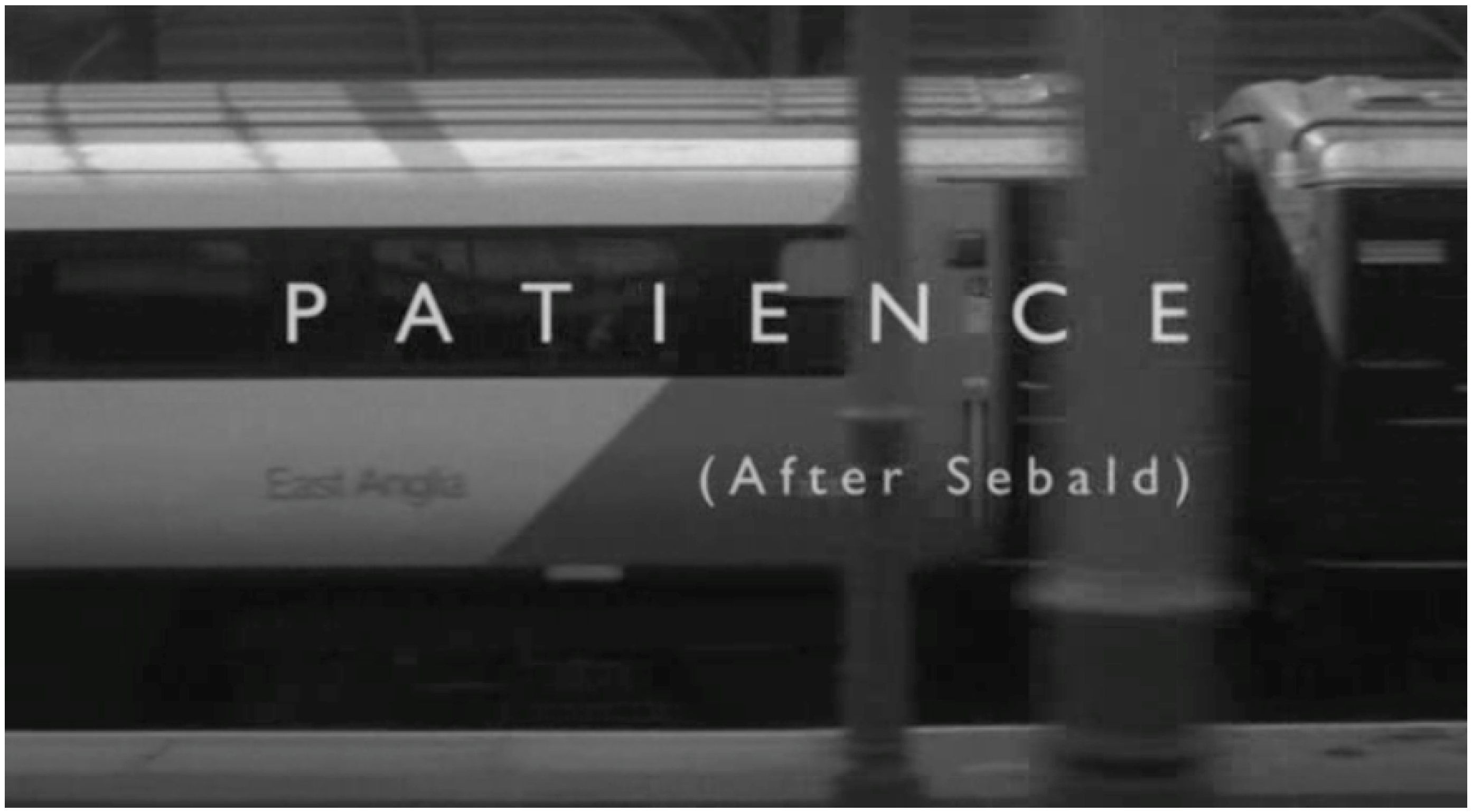
A recent film
Patience (After Sebald) by Grant Gee [
11] can be considered a deep map, one that demonstrates a necessary synthesis of story map and grid map, or the narrative and the functionalistic, by using both as frameworks for a cinematic exploration.
Patience literally follows in the footsteps of writer W.G. Sebald, in modes of film essay/biography/travel documentary, by traversing the same path described in Sebald’s literary work
The Rings of Saturn [
12]. It is not a direct translation of the book, but rather the director’s experience of those same landscapes, mixed in with a more traditional “talking heads” documentary approach with interviews of people who knew or have been influenced by Sebald. It is the story about pilgrimage, which, as Macfarlane points out in an interview within the film, is the subtitle of the English version of the book (originally written in German). Lise Patt, editor of the anthology
Searching for Sebald and another interviewee, makes note of the “image” in the word “pilgrimage.” She points to medieval itinerary maps with images of the pilgrimages for those who did not actually go on the journey. People would use the maps to meditate upon, to move their minds through the different parts of the journey on the way to Jerusalem. Thus, in addition to being a meta-travelogue—that is, a travel story about a travel story—
Patience functions as a kind of image-map, addressing the question of how both locational knowledge and emotional experience of place can be transmitted through cinema.
Cinematic narratives and maps have been linked since the earliest days of silent filmmaking, when newsreels and travelogues provided glimpses of distant lands [
13,
14,
15]. Maps and travel films both provide a sense of possibility and accessibility to “foreign” lands that, as Tom Gunning points out, “forms a cornerstone of the modern worldview in which technology can render every distant thing somehow available to us” ([
14], pp. 27–28). In addition, filmmakers and cartographers are closely related through their attempts in visualizing the world, as Teresa Castro shows in her essay “Cinema’s Mapping Impulse” [
16]. She identifies three “cartographic shapes” that are present in cinema: the aerial view, the panorama, and the atlas. Each of these shapes are very different: “if panoramas maximize the notion of point view, atlases relate to a way of assembling images, while aerial views concern a particular angle of view” ([
16], p. 11). Through Castro’s cartographic shapes, I propose to trace some of the functions and tropes of cinematic cartography and its relation to cartographic cinema, as they are used in
Patience (After Sebald). I suggest that cartographic cinema can be especially effective in relating the tour, that is, narrative, the human perspective and the movement through place, while the map remains necessary to delineate location.
Patience (After Sebald) offers a variety of cinematic and cartographic strategies, including both the map and the tour, which, I argue, are both necessary not only to have a deep understanding of the world and our place in it, but also in how to transmit that knowledge to others.
2. Cinematic Cartography/Cartographic Cinema
W.G. Sebald was a German writer who, at the time of his early death at the age of 57, had been cited by literary critics such as Susan Sontag as one of the world’s greatest authors [
17]. His works are a strange and unique blend of memoir, travelogue, history, and fiction, particularly concerning the trauma of the Second World War. British filmmaker Grant Gee, on the tenth anniversary of Sebald’s death, released the documentary film
Patience (After Sebald), a cinematic pilgrimage that follows Sebald’s tour of the areas around the University of East Anglia, England, where Sebald taught for much of his later life. Elements in
Patience take off from cinematic cartography, showing the locations of Sebald’s walking tour of Suffolk as well as the locations mentioned in the spiralling and divergent narrative, as plotted out on Google Maps. This use of the grid map allows for a geographical overview of place, a precise pinpointing of location. Cartographic cinema is also a device used in the film to describe architecture and landscapes, and allows the more subjective experience of place to filter through the imagery. Both of these modes of cinematic cartography are necessary to the narrative, and this documentary is perhaps the first to relate the different mapping practices together quite consciously. In fact, Gee has studied geography and even completed a year towards a Ph.D. in the field [
18]. He has undoubtedly read—and even interviews in the film—some of the same writers that I draw upon in this analysis (Robert Macfarlane, for instance).
Cinematic cartography is a rapidly growing subfield of interdisciplinary study, as evidenced by a plethora of books recently published on the subject (for example, see [
19,
20,
21]). The term has been used to describe many different relationships between mapping and cinema. Les Roberts, in his essay “Cinematic Cartography: Projecting Place Through Film” [
22], identifies five different main approaches, or clusters, as he calls them, which are by nature inexact and overlapping. Of the five clusters mentioned, four can be found in
Patience, the exception being the mapping of film production and consumption. Gee brings in maps and mapping in film, that is, the plotting of geospatial data onto a map, as already discussed, as well as movie mapping and cinematographic tourism; cognitive and emotional mapping; and film as spatial critique. In this essay I suggest a differentiation between cinematic cartography as specifically the use of maps to plot out a film’s spatial data, and cartographic cinema as the exploration of space through the moving image, which often includes cognitive and emotional mapping and film as spatial critique.
Castro addresses cartographic cinema, particularly how both cartography and cinema share “a particular way of seeing and looking at the world, a visual regime” ([
16], p. 10). She draws on Svetlana Alper’s book
The Art of Describing [
23], which shows that seventeenth century visual culture in the Netherlands, including maps and paintings, were historical modes of thought impacting how space is represented in modernity. Through an investigation of three cartographic shapes, Castro also links these views to war, as they were made possible by wartime technology and used for military applications. This has relevance to today’s digital maps that are made possible through satellite technologies, also invented for military purposes. The themes of landscape, history, and war are all prevalent in Sebald’s work, and further support the usefulness of Castro’s three cartographic shapes to this analysis. I also extrapolate their significance to modern digital technologies, including online mapping services such as Google Maps and Google Street View. And finally, I suggest that the combination of both grid and story map can be achieved through cinema as an extremely useful tool for the practice of deep mapping, particularly as a compelling way to associate emotions, stories and histories with geographic locations.
3. Cinematic Cartography and the Mapping of Location
Maps have often appeared in films to provide locational grounding and to lend realism or metaphor to the narrative, whether documentary or fiction [
13]. However, it is only more recently that cartography has included the practice of plotting a film’s, or any other kind of narrative’s, locations on a map. As Sébastien Caquard in “Mapping Narrative Cartography” notes, “maps are more and more commonly used as an analytical tool to explore the spatial dimension of narratives, marking the emergence of hybridized practices” including literary and cinematic mapping ([
24], p. 135). Barbara Piatti
et al. point out that there are examples of literary maps dating back to the beginning of the 20th century, for instance, William Sharp’s map of Scotland depicting the zone of action for several novels by Walter Scott. However, they argue that these early experiments in literary geography were rudimentary and illustrative of other written texts, without having much weight of their own, and maintain that it has only been since Franco Moretti’s work
Atlas of the European Novel (1998) have narrative maps “become truly tools of interpretation, allowing to see something which hasn’t been evident before” ([
25], p. 180).
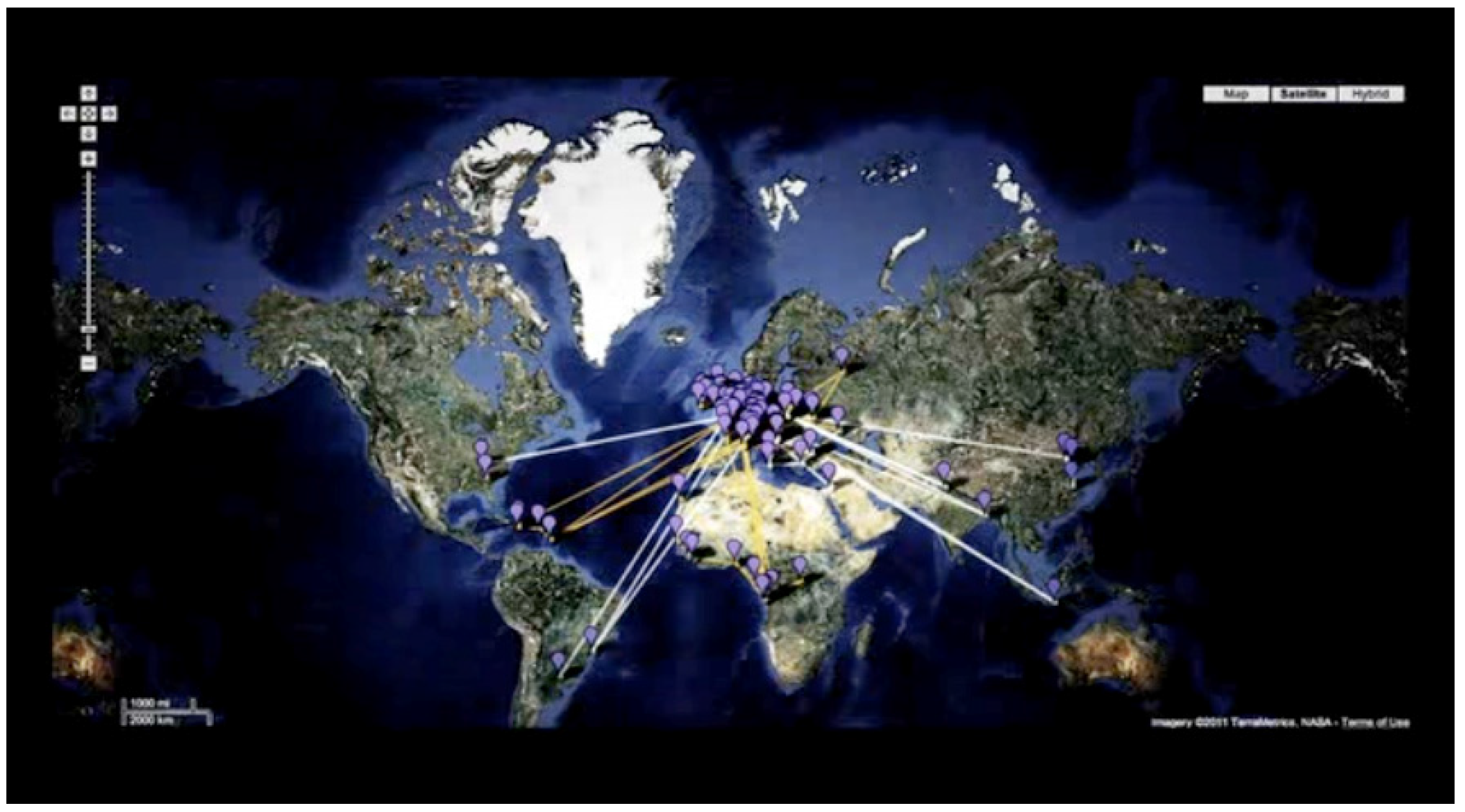
In Patience (After Sebald) the very first image that we see is a Google Map with placemarkers and lines stretching out all over the world (see
Figure 1).
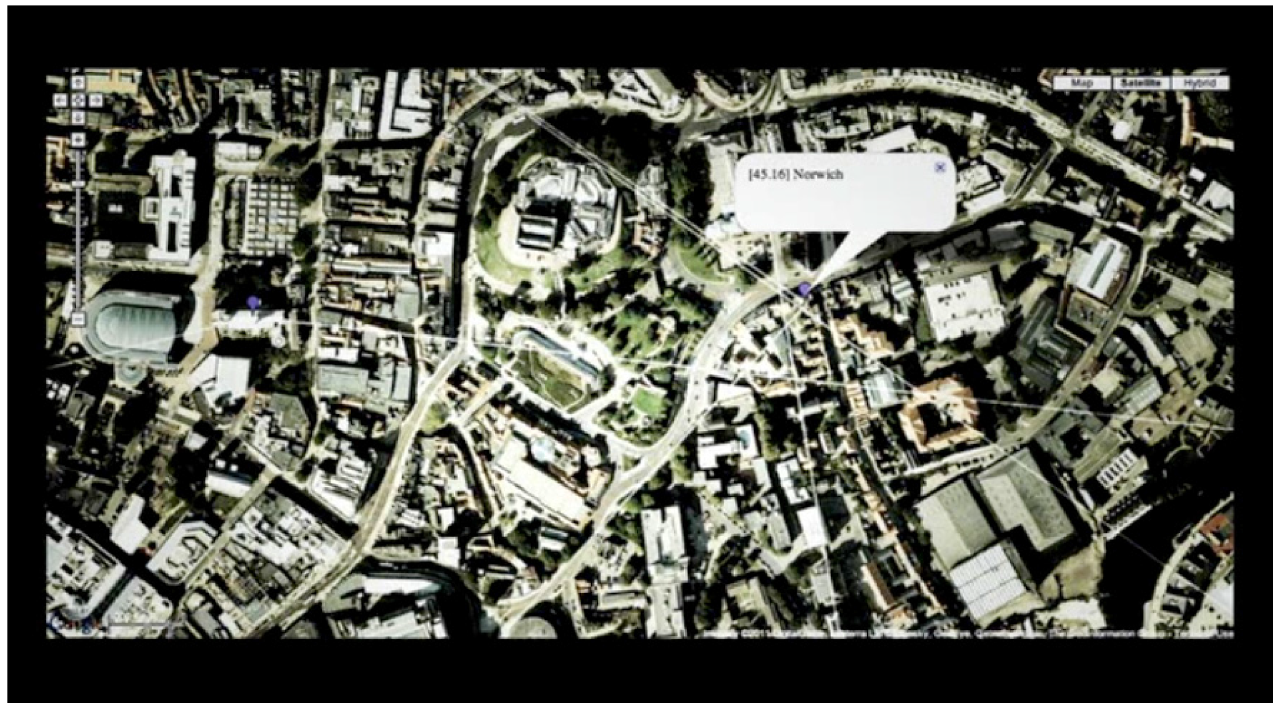
We begin to zoom in to England, where the majority of placemarkers are found, to the sound of birds and the crack of a rifle. We keep zooming in, jump cuts simulating the redrawing of the computer screen that happens in Google Maps. We begin to make out details in the satellite images of the land. As buildings and roads take shape, a placemarker pops up, reading “Norwich”, where Sebald’s book The Rings of Saturn begins (see
Figure 2).
Figure 1.
Screenshot from the opening sequence of the film Patience (After Sebald) by director Grant Gee (2011), showing placemarkers and connecting lines on the world map.
Figure 1.
Screenshot from the opening sequence of the film Patience (After Sebald) by director Grant Gee (2011), showing placemarkers and connecting lines on the world map.
Figure 2.
Screenshot from the opening sequence of the film Patience (After Sebald) by director Grant Gee (2011), showing “Norwich”.
Figure 2.
Screenshot from the opening sequence of the film Patience (After Sebald) by director Grant Gee (2011), showing “Norwich”.
Barbara Hui, writer and creator of the Litmap project, is one of the interviewees in Patience, and it is her Google Maps mashup that opens and frames the film’s narrative (a mashup combines data or content from several different sources). Hui relates how, since Sebald’s book is full of geographic place names, she decided to plot each place using the Google Maps Application Programming Interface (API) tool. Hui uses the colour red on the map to indicate places from Sebald’s actual walking tour, with links out to the places that he mentions as his thoughts are roaming. This use of maps in the film works doubly as literary cartography that plots the locations of a work of literature and cinematic cartography about where the film was shot as well.
This instance of narrative cartography conveys an immediate and explicit spatial dimension to the analysis. One is able to see the lay of the land, the distances involved, how things are in relation to each other, the shape of the coastlines, the topography, the outline of the journey. These are all extremely helpful things in setting a film or fleshing out any kind of narrative, and maps often appear in films for these reasons. The use of the digital map in
Patience also indicates how many place names are mentioned in the book’s narrative, and that these are very specific locations of the world, aiding in the documentary aspects of the film. And finally, as Hui points out, “in
The Rings of Saturn, Sebald illustrates a spatialized view of history that sees the local as globally defined” [
26]. This is shown graphically through the use of connecting lines that join distant countries to the places of Sebald and Gee’s walking tour. Local history cannot be disassociated from global history.
Hui acknowledges, however, that there are certain challenges and limitations with her project, and with narrative cartography in general. For instance, she points out that “Sebald has a ‘cosmological’ notion of historical space in addition to the local and global one. It is not possible to map this cosmological notion of space using the Google Maps API!” [
26]. Sebald’s writing is a hybrid of travelogue, autobiography, history, and fiction, among other genres, and as Piatti
et al. have pointed out, there are particular challenges in mapping fictions, even those based in real world counterparts [
25]. Locations may be vague, partly or completely invented. In addition, Hui points out that the use of Google Maps or similar “restricts the user to that vision/version of geographical space. When you’re working with that data, be aware that you’re working with those pre-provided layers of information, which have their own inherent assumptions built in” [
26].
Wood calls maps “arguments about existence” ([
9], p. 34). They tell stories through what is included and what is left out. Colonial maps, for instance, helped to shape nations and states by presenting them as united by imaginary borders [
27]. Instead of colonial interests, the digital grid map, most popularly represented by Google Maps, now depicts commercial ones, a view of the landscape as places of consumption. The Google satellite view seen in the film thus adds other layers of meaning, with its scientific overtones and notions of indexicality. It gives as well the pleasure of being able to see the whole Earth from an exotic and in fact impossible angle. It places a grid upon the world, so that anything can be found according to exact coordinates of longitude and latitude, thus, the term “grid map” as advanced by Macfarlane.
The grid map of Google’s satellite view corresponds with Castro’s aerial view, in that both strive through photographic means to make accurate plans of the land from above. They both aim to make landscapes into maps as accurately as possible, and they are both associated with military uses as well as pleasurable and thrilling emotions. Castro, in her discussion of the aerial view as a cartographic shape, looks at films shot from balloons, dirigibles, and airplanes, which were part of an increasingly popular theme of travel during the early part of the 20th century. She points out that the Lumière brothers had made films shot from hot-air balloons as early as 1898. Castro focuses particularly on one film,
En dirigeable sur les champs de bataille (1918), which was made by the Cinematographic Service of the French Army (Service Cinématographique de l’Armée). Shot from a dirigible shortly after the First World War, the camera flies over the combat zones of Northern France, exposing precise quantities and locations of the devastation, while “the smoothness and fluidity of its aerial movement represent an unquestionable source of emotion” that includes the visual pleasure of a novel angle of vision, the horror at the ruins of war, and the “e-motion” of the feeling of flying through space ([
16], p. 14). Such “airplane maps” were part of a larger post-war documentary and cartographic project that needed accurate plans in order to progress in the reconstruction. In addition to an inventory of the land, such images also acted as nationalistic propaganda “in particular because of their insistence on the image of a sacrificed land and on the urgency of the rebuilding campaign” ([
16], p. 14).
The aerial view pre-dates the satellite view, of course, but anticipates how science, accuracy, and representational economies (particular scopic regimes) have transformed the world into the gold of “tradeable values” ([
28], p. 22). The satellite view is able to take the aerial view to the extreme, framing the entire planet in its view. There have been incredible advances and benefits made possible by such grid maps, but while they are powerful tools, as Macfarlane points out, “their virtue is also their danger: that they reduce the world only to data, that they record space independent of being” ([
2], p. 141). One might see the grid map as useful for locating and positioning and for mapping surfaces, but inappropriate for mapping the deeper layers of story, emotion and history. The Google Map can tell me where Norwich, East Anglia or Somerleyton Hall is, geographically, but otherwise, to me, not being familiar with the area, they are just names, placemarkers, or points on the map.
How then to trace and convey the narratives and contexts without losing location and cartographic functionality? As Sébastien Caquard and Fraser Taylor note, the diversity and power of cinematic approaches to evoke emotional, political and personal dimensions of a place contrasts with the scarcity of those dimensions in cartographic practices [
29]. A hybridized cartographic cinema can help map and convey the affective experiences of place, as the next two sections will explore.
4. Cartographic Cinema and the Mapping of Space
From the Google Maps mashup in the opening shots of
Patience, we move to a long horizontal tracking shot of an East Anglia train, which we would infer (if we are following along with book in hand) is leaving from Norwich, bound for Somerleyton Hall, Sebald’s first stop (see
Figure 3). The film cuts from the satellite map of the world to the street level point of view on the train station, encapsulating the movement to the second of the three “cartographic shapes” of the film: the panorama. A beautiful black and white extended tracking shot travels the length of a train, the words “East Anglia” on the sides of the coaches, giving way to travelling shots from the train, of the tracks and the countryside.
Figure 3.
Screenshot from the opening credits sequence of the film Patience (After Sebald) by director Grant Gee (2011), showing the panoramic viewpoint.
Figure 3.
Screenshot from the opening credits sequence of the film Patience (After Sebald) by director Grant Gee (2011), showing the panoramic viewpoint.
Tom Conley, in his book
Cartographic Cinema, contends that “[e]ven if a film does not display a map as such, by nature it bears an implicit relation with cartography” ([
30], p. 1). The panorama is evidence of this. Castro describes the panorama shape as responding to “a desire to embrace and to circumscribe space, allowing for the observer’s eye to seize the whole of an image” ([
16], p. 11). She refers to early cinema’s penchant for capturing views and landscapes that represented “the careful scaling and coding of the world through filmic means, namely, horizontal and 360° panoramic shots” ([
16], p. 12). While there are few actual panoramic shots in
Patience (that is, where the camera turns or pans around, rotating on a tripod axis), there are numerous horizontal tracking shots that guide the spectator through time and space. Even when there is no camera movement, the landscapes that Gee films with his 16mm Bolex invite the connection to 18th and 19th century painting as well as modern landscape photography, invoking the spectacularization of landscape and the associated longing for immersion in and mastery over space. Guiliana Bruno describes, for instance, how view painting “merged the codes of landscape painting with urban topography” ([
31], p. 61), which has been absorbed into the language of film. “Travel culture is written on the techniques of filmic observation” ([
31], p. 62).
Since the very idea of travel is made possible through maps and the provocation of the imagination, tourism, consequently, has become about ways to consume the images of places depicted as spectacular views. As Gunning points out, travel films played a major role in the selling of early cinema with its emphasis on spectacle and attraction, but these films were only the latest in a tradition of traveling lectures with slide shows, moving landscape paintings, and the stereoscope with its illusionary depth. He argues that “[t]he idea of making the world available in the form of a spectacle stretches back to the panorama of the end of the eighteenth century and to the world expositions of the latter part of the nineteenth” ([
14], p. 29). In the modern era, the concept of travel is now more than ever bound up with the production, commodification, and consumption of images, including travel shows, postcards, selfies, and maps, all of which do not simply function as substitutes for those who cannot travel, or souvenirs for those who have. They also work to structure the imagination of travel and the very experience of the journey itself, by providing a “script” of expectations.
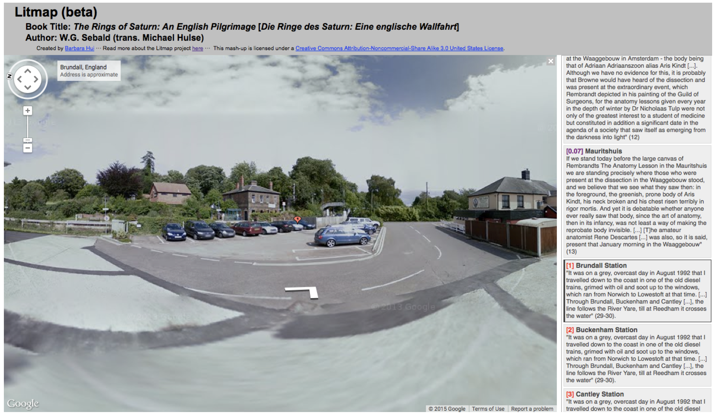
Where the aerial view has its modern counterpart in Google Maps, satellite imagery and grid maps in general, the shape of the panorama has its modern cartographic parallel in Google Street View (see
Figure 4). Google Maps launched its Street View feature in May 2007. “The underlying idea is very simple: Provide an interface that can display street-level images in a natural way that enables convenient navigation between images without losing the map context” ([
32], p. 118). Street View provides 360 degree street-level panoramas of many cities, mainly in Western countries, as well as popular tourist sites around the world. And in May 2012, Google introduced the World Wonders Project, a series of Street View tours of such famous historical sites as Stonehenge, the Versailles Palace, and Sir Robert Scott’s hut in the Antarctic. Underlying the conception of GSV is the obsession to photograph the world and make it available as never before, and in this, the Google Street View panorama “bubble” is directly connected to the panorama paintings and photos of the late-eighteenth century, as well as to early travel films.
Figure 4.
Screenshot of the
Litmap project’s website, showing a Google Street View image of the first red placemarker (Brundall Station) on Barbara Hui’s
Litmap [
33].
Figure 4.
Screenshot of the
Litmap project’s website, showing a Google Street View image of the first red placemarker (Brundall Station) on Barbara Hui’s
Litmap [
33].
The landscape panorama provides a counterbalance to the overhead aerial or satellite view. It represents the territory that was abstracted by the grid map; it speaks to the desire to move through map space, to fly into it and see it up close as landmarks, streets and buildings, as the animations of Google Earth illustrate. The panorama describes the space of being, that is, a more human point of view, and in a much more precise manner than words ever can—a picture is worth a thousand words, as the old saying goes. I never really knew what a moor looked like, for instance, until I saw a photo of one, even though moors are often the settings in English novels. However, as Bruno notes, a particular sense of place is actively generated by both images and narratives, as well as emotions [
31]. If the aerial view is an overhead map and the panorama describes the street level perspective, both of these remain surface mappings, representations of space that have no history or context without the third cartographic shape, that of the atlas.
Patience is, in many ways, about the interrelations between the map and the tour, and the need for narrative and meaning that is made possible through the atlas view of montage and story, as the next section will explore.
5. The Atlas as Montage and Meaning
Immediately after the film’s opening sequence that sets up the mapping discourse with the overhead view and the panorama, Gee introduces the first explicit connection between a place in the book and a place in the film. This is Somerleyton Station, where Sebald and Gee get off the train. The reference in the book is given to us on the screen, along with a small rectangle of colour (of a man walking alongside a departing train—perhaps the filmmaker himself?) superimposed upon a background of grainy black and white field (see
Figure 5). Gee’s various visual strategies such as this superimposition, as well as the use of montage in general to organize images thematically, can be seen to correspond to the atlas as a cartographic shape. Castro’s atlas refers not only to a collection or archive of images that aim to convey geographical knowledge as well as history, but also “a means to organize visual knowledge. In other words, atlases refer as much to a strictly cartographic instrument as to a graphical means for the assemblage and combination—if not montage—of images” ([
16], p. 13). As Christian Jacob points out in his book
The Sovereign Map [
34], the similarities between the author of an atlas and the editor of a film reside in their use of such elements as framing, rhythm, focus, a sense of progression, and structure.
Figure 5.
Screenshot from the film Patience (After Sebald) by director Grant Gee (2011), showing an assemblage of two different viewpoints.
Figure 5.
Screenshot from the film Patience (After Sebald) by director Grant Gee (2011), showing an assemblage of two different viewpoints.
The editing of landscape scenes in
Patience often functions as assemblages and combinations that aim to convey geographical information as well as dual points of view. For instance, the black and white landscape footage is often presented to illustrate Sebald’s words, while the smaller rectangle alludes to the filmmaker’s experience of the same landscape through a handheld camera point of view, often of his walking feet. Elsewhere, montage sequences of cliffs, beaches, or moors give evidence of an atlas-view towards conveying different parts of a landscape. Sebald describes his own experiences of feeling both liberated and despondent whilst moving through the landscape, and often touches off from a chance encounter, a particular place or the history of that place, to spiral out into something else, an encyclopaedia of people and things that he is interested in. Gee replicates Sebald’s strategy, using a combination of the panorama and the aerial cartographic shapes, as well as Hui’s Google Maps mashup, to give various layers of geographical knowledge, from topography and location to distance and point of view. For instance, he reproduces Sebald’s photos from the book, superimposing over them his own footage of the same place (see
Figure 6).
Figure 6.
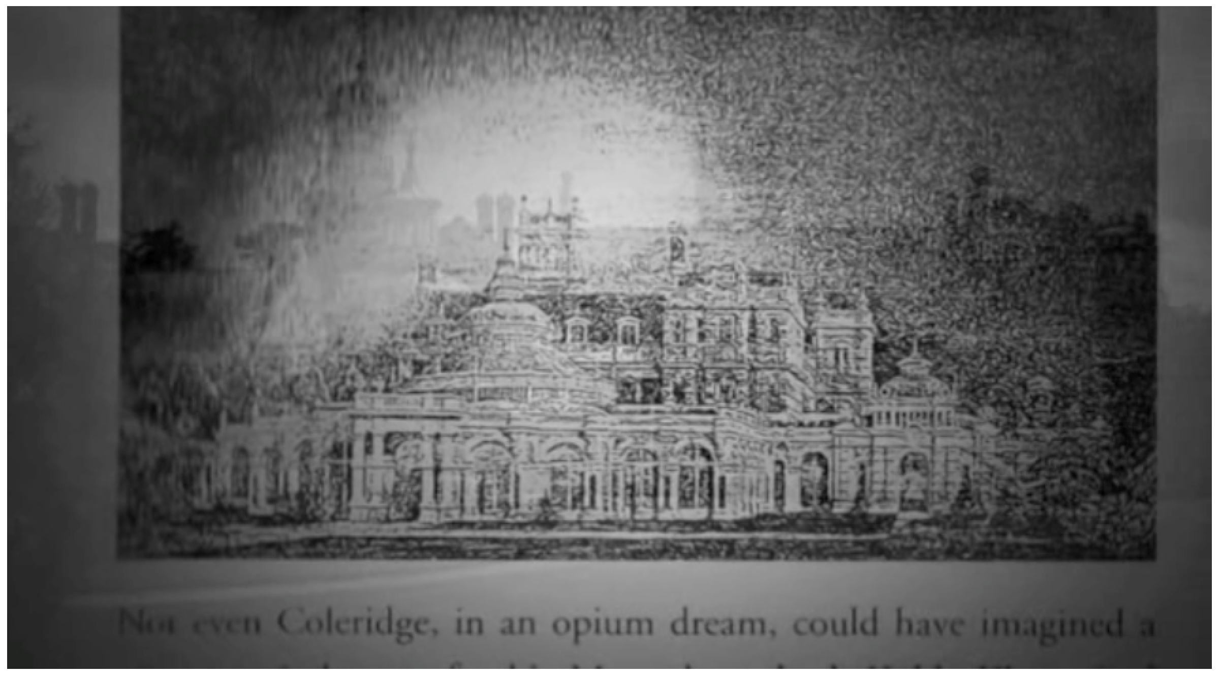
Screenshot from the film Patience (After Sebald) by director Grant Gee (2011), showing an image of Somerleyton Hall from Sebald’s book The Rings of Saturn superimposed on a cinematographic image of the same view.
Figure 6.
Screenshot from the film Patience (After Sebald) by director Grant Gee (2011), showing an image of Somerleyton Hall from Sebald’s book The Rings of Saturn superimposed on a cinematographic image of the same view.
Alone, visual strategies, whether maps or panoramas, are not enough to give a full sense of place. They are tools for the mapping impulse to describe space, and to open the way for the tour, for narrative, (auto)biography and history, which deepen the picture. This next scene in the film constructs a narrative spiral, following that of the book’s, to recount Sebald’s chance meeting with a gardener at Somerleyton Hall. The gardener finds out Sebald is German, and tells him about the planes setting out from the 67 airfields in East Anglia to bomb Germany. Over this, we see what looks like archival footage of warplanes and bombs, projected on a screen. This is the aerial view in the original usage of the term which, as Castro points out, was associated with war and military operations. In the film, we see aerial footage from the East Anglian Film Archive, shot from planes dropping bombs onto a large target painted in white lines on a green field (see
Figure 7).
Figure 7.
Screenshot from the film Patience (After Sebald) by director Grant Gee (2011), showing archival footage from the East Anglian Film Archive.
Figure 7.
Screenshot from the film Patience (After Sebald) by director Grant Gee (2011), showing archival footage from the East Anglian Film Archive.
This scene does several things. It introduces the themes of war and death that are prevalent in much of Sebald’s work, it visually illustrates the irradiating melancholy and its impact upon the landscape—an emotional mapping—and also tells both a history of the area and a story of an encounter with a local, a chance meeting on the pilgrimage. Whether the story is factual or fictional is irrelevant, since either way, it conveys an emotional connection. The montage works to relate the different cartographic shapes together in exploring a single place, but also emphasizes the importance of the tour in relation to the map. In this depiction of East Anglia, the Second World War can be read as part of the landscape, but requires narrative and the human dimension to be fully accessible. At the same time, without the location of the place on the map, one would not have a clear idea of East Anglia’s geography and its relationship to the world. Gee’s montage of images and the trope of “screen projection” to connote archival imagery play in concert with Sebald’s telling of a story to make emotional and historical meaning of the place. Through this cinematic deep mapping, East Anglia now means something more to me than when it was simply a point on a map.
6. Conclusions
Visual knowledge remains on the surface, a “shallow” cartography that is a “tracing” rather than a deep map. How can maps also function to transmit deep knowledge? Spectacular and well-known destinations remain tourist clichés without contexts, local points of view, and narratives, while more mundane places remain simply abstract points on a map that hold no meaning without a deep human perspective. It is becoming more and more important to find ways of expanding the tourist/traveller perspective, to provoke viewpoints about places that go beyond the consumption of images.
Castro’s cartographic shapes prove useful as a framework for exploring the relationships between cinema, cartography, narrative and the deep mapping of place. The aerial view acts as a way of ordering place. It displays knowledge from an overhead perspective and can be extended to satellite imagery. The panoramic street level view opens up a more human perspective. The cinematographic image and motion functions to map the space of being. Finally, the atlas view, through montage, functions to organize these images into thematic explorations and narratives. These are tools for the mapping impulse to describe space visually, and to open the way for the tour, for emotion, (auto)biography and history that can be revealed in the landscape through deep mapping.
Sebald’s narratives are linked to the landscape as well as to an associative cataloguing of thoughts and emotions. When something like a story or an evoked feeling resonates with a person, it affects that person’s point of view on the landscape. As Gee suggests, “the book starts to go way beyond its boundaries; you start trying to find the traces of it in the world” [
18]. In
Patience (After Sebald), Gee replicates Sebald’s associative strategy of spiralling narrative to give his film various layers of geographical knowledge, from topography and location to associations, emotions, and stories. The beautiful landscape shots work as a cinema of attraction, giving glimpses that make us want to see these places, and the associated stories give these places meaning. The grid map gives precise locations, and enables us to replicate the journey ourselves. This is how itineraries are formed, the frameworks with which to build pilgrimages and tours.
This essay began by discussing the idea of cinema as the “image” in pilgrimage, as a kind of itinerary map. The itinerary was one of the earliest forms of widespread spatial representations for travellers, mainly used by pilgrims to get to Jerusalem—the main destination of Christian pilgrimages. Although many pre-modern itineraries were only textual, sometimes they included graphics that transformed the itinerary into an itinerary map [
35]. Most people at the time could not have undertaken these journeys because of the expense and hardship involved. Therefore, these representations functioned simultaneously as practical instructions for pilgrims, imaginative instructions for non-pilgrims, and a means of engraving Christianity into the landscape by guiding the pilgrims on a common path, which encouraged the growth of services to pilgrims along these routes. Nowadays, literary and cinematic tourism has become in many ways the equivalent forms of pilgrimage. The mapping of locations that appear in novels, films and other narratives allow for people to partake in what Thierry Joliveau calls “set-jetting” [
36]. This is another aspect of cinematic cartography found in Gee’s film.
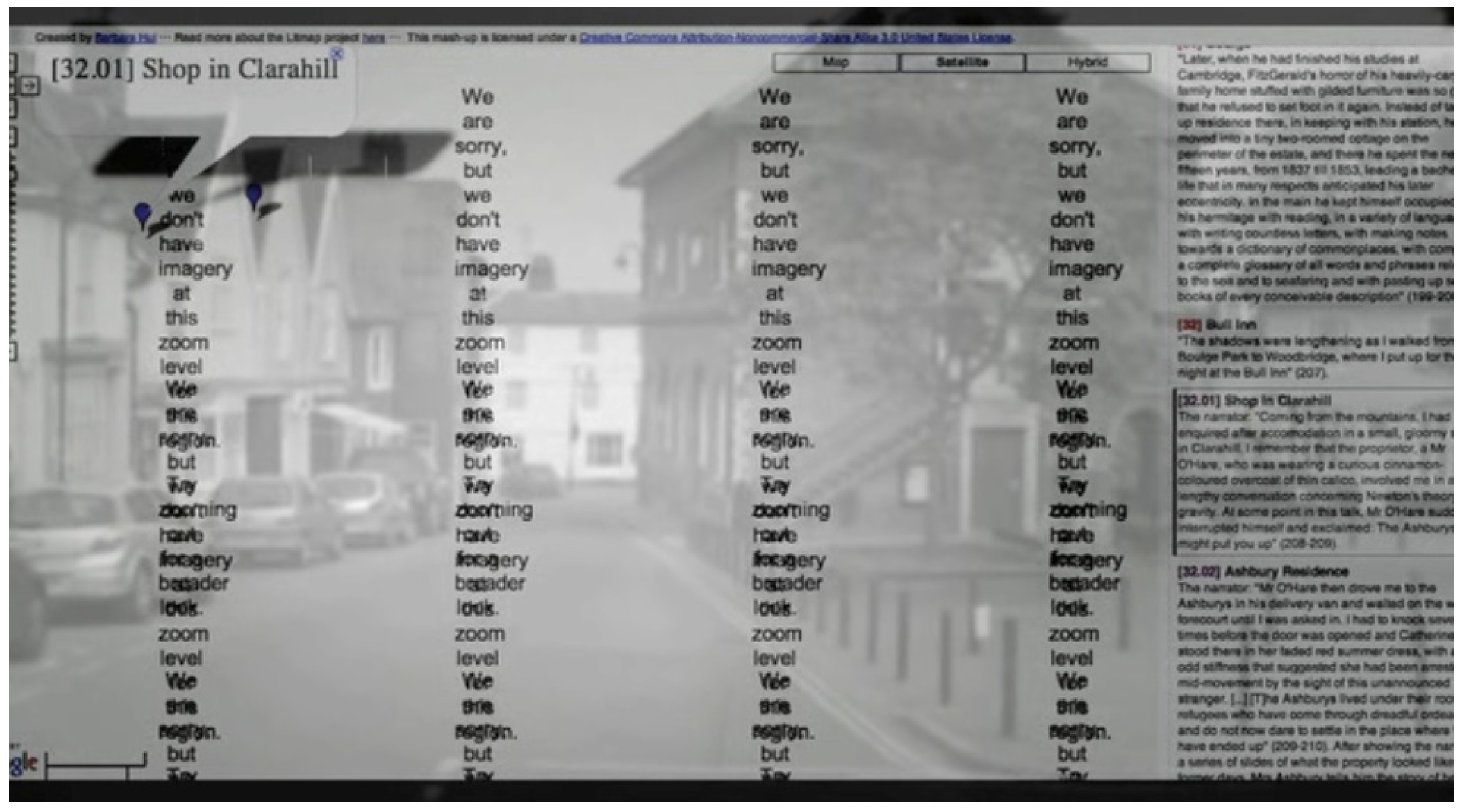
Iain Sinclair is interviewed in the film saying that replicating Sebald’s walking tour, as many people are now doing, is “a pilgrimage because the man is dead and he is ripe for a cult…we cannot literally follow along because he’s a mythologist. Many of the things in there he’s invented...But why not do that walk? It’s a great walk, enjoy it.” Macfarlane, also in the film, talks about the British tradition of walking as recovery from the accumulations of the city, while the American tradition of walking is more as discovery. Both Sinclair and Macfarlane are known for their interest in deep mapping or similar practices, but they point out that there is only so much that one can learn from maps, cinematic or otherwise. There is no replacement for the actual experience of walking, of being there. Gee alludes to this with a sequence in the film where Hui speaks about the amazement and thrill of being able to find and visit some of the actual places in
The Rings of Saturn, such as the Bull Inn or the “Shop in Clarahill”. She is showing where these places are on Google Maps, but then, as she attempts to zoom in ever closer, the map disappears into an error message that reads “We are sorry, but we don’t have imagery at this zoom level.” Superimposed behind this apology, faintly, is a cinematographic image of the place from the street level view (see
Figure 8).
Figure 8.
Screenshot from the film Patience (After Sebald) by director Grant Gee (2011), showing a Google Maps error message superimposed on cinematographic footage of a street.
Figure 8.
Screenshot from the film Patience (After Sebald) by director Grant Gee (2011), showing a Google Maps error message superimposed on cinematographic footage of a street.
Gee includes this scene as a suggestion that grid maps are limited in their viewpoints. Without the grid map, the street view has no location, and cannot be visited. However, because the overhead grid map cannot give a sense of the space of being, the street level view is able provide a more human perspective. However, the best way to learn about the world is by moving through it, although that movement may be physical or mental, and deep mapping practices suggest that it is both. Maps certainly help to get one started, to get out into the world to make one’s own experiences, but for those who cannot make the journey, and for those who wish for a guide, cinema as image-map can provide both location and narrative. Patience (After Sebald) can be thought of as a kind of itinerary map that guides one through a personal and emotional topography, both Sebald’s and Gee’s. It illustrates how cinema can function as an especially powerful tool for deep mapping, as it can both record and recount the narratives, emotions, memories and histories, as well as the locations and geographies that are associated with a place, for a deeper understanding of the world in which we live.


