


Definitions, Classification Schemes for Active Faults, and Their Application

1
Key Laboratory of Active Tectonics and Geological Safety, Ministry of Natural Resources, Beijing 100081, China
2
Institute of Geomechanics, Chinese Academy of Geological Sciences, Beijing 100081, China
3
Research Center of Neotectonics and Crustal Stability, China Geological Survey, Beijing 100081, China
4
Institute of Earthquake Forecasting, China Earthquake Administration, Beijing 100036, China
*
Author to whom correspondence should be addressed.
†
This author contributed equally to this work.
Geosciences 2024, 14(3), 68; https://doi.org/10.3390/geosciences14030068
Submission received: 21 November 2023
/
Revised: 17 January 2024
/
Accepted: 5 February 2024
/
Published: 4 March 2024
(This article belongs to the Special Issue Active Tectonics and Earthquakes)
Abstract
:Active faults are generally defined as faults that have moved in the past and will continue to be active in the future. They are expected to cause deformation and potential disasters if they are localized close to human activities. The definition and classification of active faults are important bases for evaluating the risk. This paper summarizes and compares the history, status, and progress of their definition and classification schemes used in representative countries and regions, as well as in some relevant standards, in active fault mapping, in the construction of spatial databases, and in some other aspects. It is concluded that the current geodynamic setting, existing technical means, geological operability, application purpose, and social acceptability of active faulting hazard in a specific area comprehensively determine the selection of the definition and classification. The key parameter in defining active faults is the time limit. It usually involves four time scales, i.e., Neotectonic (post-Neogene), Quaternary, Late Quaternary, and Holocene. The definition using a short time scale, such as Late Quaternary and Holocene, is usually suitable for the plate boundary zone, which has a high strain rate, but active faults in the intraplate deformation region and stable continental region should be defined with a long time scale, such as the Quaternary and Neotectonics. In addition, the magnitude standard can determine the activity intensity of active faults, which most generally includes three classes, namely, M ≥ 5.0 damaging earthquakes, M ≥ 6.0 strong earthquakes, and M ≥ 6.5 earthquakes that may produce surface displacement or deformation. The M ≥ 5.0 earthquake is generally applicable to regional earthquake prevention and risk mitigation in many countries or regions, but the M ≥ 6.5 earthquake magnitude benchmark is generally used as the standard in rules or regulations regarding active fault avoidance. The most common classification schemes in many countries or regions are based on fault activity, which is reflected mainly by the fault slip rate and fault recurrence interval (FRI), as well as by the last activation time. However, when determining the specific quantitative parameters of the different activity levels of faults, it is necessary to comprehensively consider the differences in activity and ages of the faults in the study region, as well as the amount and validity of existing data for the purpose of classifying different active levels of faults effectively.
1. Introduction
Active faults are the result of lithospheric or crustal deformation caused by the current tectonic stress field, resulting in the reactivation of older faults or the emergence of new faults. As the main source of destructive earthquakes, they signify the potential risk of fault rupture hazards and seismic hazards [1]. Those hazards mainly include surface ruptures, collapses, landslides, rockfalls, avalanches, dammed lakes, mudslides, sand liquefaction, land subsidence, ground fissures, and groundwater changes, as well as the surface displacement and ground subsidence caused by the creeping faults. They are major threats to important transportation facilities, large hydropower dam sites, nuclear plants, nuclear waste treatment sites, and densely populated urban districts, as have been experienced by several cities. The 1906 San Francisco Mw7.9 earthquake, the 1923 Tokyo Mw7.9 earthquake, the 1976 Tangshan Mw7.6 earthquake, the 1994 North Ridge Mw6.7 earthquake, the 1995 Hanshin Mw6.9 earthquake, the 1999 Izmit Mw7.6 earthquake, the 1999 Chi-Chi Mw7.7 earthquake, the 2008 Wenchuan Mw7.9 earthquake, and the 2023 Turkey Mw7.8 earthquake (https://www.usgs.gov/programs/earthquake-hazards/earthquakes, accessed on 1 July 2023), are just a few of the many examples that have caused extensive damages and human losses.
Buildings and/or infrastructures that are astride active faults are usually the biggest victims of an earthquake. It is considered that active fault avoidance is generally an effective measure to essentially prevent the risk of active faulting hazards, as adopted by several cities in western America and New Zealand [2,3,4]. To avoid the hazards of active faults to major infrastructure and project sites in the process of city planning, the exact location and the activity of the active faults should be determined. It should be known that defining active faults in the right way and selecting the appropriate classification scheme, considering the specific conditions, is the foundation for active fault identification.
Due to the different clients, application purposes, and the bearing capacity of active faulting risks in engineering, many academic societies and government regulators have developed special technical specifications and industry standards to regulate the investigation and surveying of active faults [5,6,7,8,9,10,11,12,13,14]. It can be concluded that the definition and classification among them are distinct, even contradictory or confusing, making their use difficult.
Improper definitions can both exclude originally hazardous active faults, thus preventing effective risk mitigation, and add to the difficulty of active fault identification or even make it ineffective. Furthermore, classifying and assessing active faults from different perspectives constitutes a critical basis for preventing active faulting risks. Proper active fault classification is also an important means of providing an intuitive presentation of fault activity and its risks.
In this paper, we update the current active fault definitions based on our previous paper [15], classify active faults, and summarize their application in some countries in the world. The aim is to provide a valuable reference for industries and government departments to use a proper definition and develop an appropriate classification of active faults to meet their needs.
2. Definition of Active Faults
2.1. Basic Definition of Active Faults
The term “active fault” was first introduced by Lawson (1908) [16] after the 1906 San Francisco Mw7.9 earthquake. In the early 1900s, Wood (1916) [17] and Willis (1923) [18] defined a fault as an active fault when it possessed the following four basic attributes: (1) Surface displacement in the current seismotectonic period. (2) Probability and tendency of reactivation or regenerating surface displacement in the future. (3) Geomorphic evidence of modern activity. (4) Possible concomitant seismicity. Slemmons and McKinney (1977) [19] suggest that an active fault should have one of the following three types of evidence: “geological, historical, or seismic”. Specifically, when there is conclusive evidence of activity in the modern geological period and modern sedimentation, such as alluvial fan or alluvium, is cut (Figure 1d) or there has been surface dislocation in the historical period, or there is evidence of seismic activity distribution along the fault. Matsuda (1977) [20] defined an active fault as “a fault that has been active for many times in the Quaternary or late Quaternary and may be active again in the future”. Allen et al. (1974) [21] gave a time limit of 100,000 years to identify an active fault for the first time.
In the above studies, it has been emphasized that the accumulated dislocation marks during the late Quaternary period are key for identifying active faults since one single dislocation of the sedimentary layer or geomorphic surface is not always caused by active faulting. For example, the cumulative dislocation process of gullies or river systems can indicate the deflection of active strike-slip faults (Figure 1a,b), while the fault facet on the basin-mountain boundary and the fault scarps cutting through the late Quaternary geomorphic body are often the geomorphic indicators of active normal and reverse faults (Figure 1c).
2.2. Time Limit of Active Faults
The main focus of the divergence in the definition of an active fault is the time limit (or time window), that is, exactly the past activity of the active fault, which is also the primary problem facing the identification of an active fault. In the early definition, more emphasis was placed on “faults that have been active for many times in the recent or latest tectonic stage”, and there was no clear time limit. It is common to use terms with relatively vague time intervals such as “recent geological period”, “current or present”, “young” and “historical”. This leads to different time limits for active faults in geology, seismology, engineering geology, and other industries and relevant laws, regulations, and specifications due to different understandings or use purposes [22]. Therefore, the difference in the definition of “active fault” is mainly reflected in the time limit of “the latest tectonic stage” [14,23,24]. According to the existing definitions in the world, the time limit of active faults is mainly concentrated on four different time scales: “Holocene, late Quaternary (since late Pleistocene or middle Pleistocene), Quaternary, and Neotectonic (since Pliocene or Neogene)” (Figure 2).
The time limit in the definition of active fault essentially reflects the history of fault activity, that is, to judge whether it will resume or continue its activity in the near future by understanding its activity from the past to the present, so it is the criterion for determining active fault, not the definition itself [23,26]. Although the time limit is critical for identifying fault activity, it cannot directly determine whether the fault will be active in the future. According to Wallace (1986) [27], human activities and engineering construction are most concerned about the possibility and risk of future activities of faults, that is, “whether the faulting or tectonic deformation process will continue and cause disasters within the period of concern of human society”. For example, for the site selection of major projects such as dams and power stations, the most important concern is whether fault activity and disasters will occur within their design service life (usually on the scale of 100 years), as well as the risk. Therefore, it is not scientific to artificially assign a fixed time limit for the definition of an active fault. The more universal definition should be “fault that can still be active in the future of human concern” [28]. In recent years, this concept has been widely accepted, for example, in the definition of an active fault in the new version of “Geological Vocabulary” in the United States: “faults that have been active recently and may still be active in the future” [29]. The definition used in the USGS seismic glossary is “faults that may produce seismic activity at some time in the future, especially those that have been active once or more in the past 10 ka” (Earthquake Glossary-active fault [EB/OL]. http://earthquake.usgs.gov/learn/glossary/?term=active%20fault, accessed on 1 July 2023).
When considering risks, the core of active fault is “the possibility of future activity”. The time limit in the definition should be open rather than a fixed value. In engineering applications, especially for standards, specifications, and legislation that emphasize preciseness and operability, the definition of the active fault must give a clear time limit to be operable. In this case, the relatively reasonable and scientific time limit of an active fault should be determined according to the project needs and the project life concerned, and after comprehensive consideration of the regional geodynamic setting and tectonic environment, application purposes, actual needs for disaster prevention and mitigation, and geological operability and other factors [23,24]. If the service life of the project is 100 years, it can be emphasized that “faults may be active in the next 100 years”. If the active faults in the site area are mainly the faults that have been active during the late Quaternary, we can focus on “faults that have been active during the late Quaternary and may still be active in the next 100 years”.
2.3. Terms Related to Active Faults
The initial definition of active fault is simple, but due to different understandings in defining the time limit, seismogenic capacity, and potentiality of hazard, as well as different requirements in engineering practice, many definitions and related terms have emerged. The following table shows some of the most frequently encountered terms (Table 1).
3. Classification of Active Faults
Active faults are defined by the need to recognize or identify fault activity. They are classified for assessing the faulting hazard, namely, to predict the potential faulting hazard and the degree of this hazard. Initially, classification was proposed when selecting the sites of nuclear power plants, when people found it necessary to classify or rate fault activity and implement appropriate countermeasures. In practice, similar active faulting hazard assessment issues are also encountered in urban planning and development. Therefore, the proper classification of known and newly discovered active faults has already become a prerequisite for finding the most effective response to active faulting hazards.
Prior to the 1970s, due to the limitations of knowledge about active faults, the classification schemes were rather simple. According to Albee and Smith (1966) [50], fault activity reflects only one single state, but the activity level is variable and can at least be distinguished into strong, medium, and weak activity. Nichols and Buchanan-Banks (1974) [51] distinguished active faults into four descending categories according to their movement frequency in the last 0.5 Ma–50 ka, 50–5 ka, and 5 ka (Table 2). Matsuda (1969) [52] also suggested that based on earthquakes, active faults can be divided into seismic faults and seismogenic faults, and based on movement patterns, they can be divided into creep-slip (creep movement) faults and strick-slip (seismic movement) faults. The former is characterized by constant, slow movement, generally producing no earthquake or only small earthquakes; the latter is characterized by sudden, rapid displacement (generally realized as strong or large earthquakes), generally producing no demonstrable displacement when the faults are locked (manifested by a lack of strong seismicity) and are therefore called seismogenic structures [53,54].
Since the 1970s, as the investigation of active faults continued to deepen, active fault classification has matured and refined. Although a uniform scheme has not been reached yet, the most common practice is to classify active faults according to fault activity, last activation time, kinematics property, and fault scale. The classification by kinematics property is consistent with the fault type classification in traditional structural geology and is not discussed in further detail. In practical applications, single indexes, such as (i) fault activity, (ii) last activation time, or (iii) a combination thereof, are the most frequently used indexes. Among representative schemes globally regarding active fault classification, the more widely accepted and practically useful ones fall under four schemes, which are elaborated on in the succeeding paragraphs.
3.1. Fault Activity Schemes
The qualitative indexes of fault activity classification include the level of geomorphological significance of the fault and the displacement amplitude of geological bodies. The quantitative indexes mainly include slip rate, strong seismicity frequency, or earthquake recurrence interval (also referred to as “fault recurrence interval”). In the early years of active fault research, due to the limited availability of quantitative data, classification relied more on qualitative indexes.
The International Atomic Energy Agency (IAEA) (1972) [55] identified the four types according to movement rate and level of geological–geomorphological significance (Table 3). The U.S. Atomic Energy Commission (U.S. AEC) (1973) [5] recognized faults as active (in the narrow sense), capable, and dead, based on fault activity and manifestation. Grading Codes Advisory Board and Building Code Committee (1973) [56] classified faults into three types with degrading risk levels based on their relationship with earthquakes: active faults, potentially active faults—which include high-latency and low-latency faults, and inactive faults (Table 3). This scheme was also applied in the early seismic zoning efforts in California.
Over time, as more quantitative data were acquired, slip rate and earthquake recurrence interval have gradually become the main criteria for classification.
3.1.1. The Slip Rate Criterion
The fault slip rate represents the cumulative rate of strain energy of the fault and is the main quantitative indicator of the fault activity. Therefore, it has always been the key parameter in the quantitative study of active fault and fault hazard assessment. Therefore, the classification of active faults based on fault slip rate helps distinguish the difference in fault activity intensity.
The most representative in this respect is given by Slemmons and dePolo (1986) [57] based on the fault slip rate and the correlation between it and the recurrence interval of large earthquakes and the cumulative displacement during the late Quaternary period. The quantitative indexes include the average recurrence interval of earthquakes and the average slip rate of the fault. The scheme grouped active faults into six different levels, namely, AAA (extremely strong), AA (strong), A (moderately strong), B (medium), C (weak), and D (extremely weak) (Figure 3).
This classification scheme is still widely accepted and fairly reasonable up to the present day. Its main shortcoming, however, is that it targets active faults on a global scale. That is, instead of considering the distinction of activity among different types of active faults, such as intracontinental strike-slip faults, normal faults, and reverse faults, it uses a uniform quantitative criterion to classify them. When used in practical applications, the resulting activity ratings of reverse and normal faults could be lower than their real levels. Hence, further subdivision and modification would be necessary according to the fault type and regional active tectonics in the studied area.
3.1.2. The Fault Recurrence Interval Criterion
The Fault Recurrence Interval (FRI) criterion describes the earthquake frequency of an active fault. As shown by the fault activity classification scheme proposed by Slemmons and Depolo (1986) [57], FRI is generally positively correlated with the fault slip rate. That is, a fault with a high slip rate means a strong earthquake recurrence frequency, and vice versa. So, this index also represents an important quantitative indicator for evaluating fault risk.
The guideline for planning land development on or close to active faults established by the New Zealand Ministry for the Environment offers a representative example in this regard. This guideline provided a detailed scheme of classifying active faults according to the average time interval of surface rupture repeatedly caused by active faults to highlight the future risk of faults and clarify whether building or land development programs of different importance levels need to avoid an active fault or for land development to be allowed in an active fault-affected zone [58]. Under this scheme, faults are divided into six types (I–VI) (Table 4). Faults with recurrence intervals greater than 125 kyr are considered inactive in New Zealand because the definition of the active fault adopted by New Zealand is “the fault that has undergone surface dislocation or deformation since about 125 kyr ago and may still occur in the future” [59].
3.2. The Last Activation Time Schemes
The formation time of the current tectonic stress field under different geodynamic backgrounds is often different. For example, it can be as old as about 15 Ma on the relatively stable North American continent and as young as about 0.5 Ma in the California area of the United States [23]. The current tectonic stress field in the Chinese Mainland is closely related to the latest tectonic deformation and uplift process of the Tibetan Plateau under the continental collision of the India-Eurasia plate, mainly formed about 10–8 Ma ago [60,61,62,63]. This period is the so-called neotectonic period [49]. During the neotectonic period, with the continuous deformation and movement of the lithospheric plate, the fault zone must also be in the process of continuous evolution. The activity of some faults may gradually weaken or tend to stop, while the activity of other faults may gradually increase or new faults may appear. Therefore, faults with different active ages can be distinguished and classified based on the most recent dislocated strata, helping identify which faults have become inactive or tend to be inactive and which are still significantly active. The latter are usually the faults with the highest probability of reactivation. Therefore, the classification scheme of active time is often adopted by some engineering specifications and mapping guidelines, which can be demonstrated by typical examples in the United States and China (see Section 5.3 and Section 5.8 for details).
3.3. Other Classification Schemes
Apart from the representative active fault classification schemes discussed above, some authors and institutions have also proposed other unique classifications to address their respective purposes or applications.
Ding (1982) [64] suggested considering five types, according to the development stage of faults.
Juvenile: A microfracture development zone or hidden rupture zone formed in a place where the crustal shear strength is weak or where the shear stress is the most concentrated and showing no demonstrable displacement yet, often manifested by the zonal activity of small earthquakes.
Growth: A young active fault at its peak strength, often manifested by a linear fault structure with demonstrable displacement, usually with strong seismicity, frequently occurs at the end of rupture development or at the intersection with other structures.
Prime (or active stage): A mature fault zone, which implies a through-going structure at the largest available scale of a fault network that dominates the tectonic slip accommodation, comprising multiple young active faults connected together, whose seismicity differs from one segment to another but which often shows migration and transformation among the active segments.
Aging (or decline stage): A fault entering the decline stage, in which its activity is weak, is often cut or branched by younger faults and has very low seismicity and a long movement period.
Fossil fault (or dead fault): A fault that has consolidated, closed, and fully ceased to move. These faults have no seismicity at all.
The development process of active faults also approximately echoes the evolution of the activity of the faults and the progressive seismicity from weak to strong and then from strong to weak. Accordingly, distinguishing the development stages of faults is of positive value for understanding the seismic risk of faults.
The guideline for avoiding active faults prepared by the New Zealand Ministry for the Environment, in addition to the classification based on the recurrence interval of active faults, is to better determine the setback distance from active faults and take more pertinent preventive measures against the active faulting risk. Active faults are also classified into Type A, Type B, and Type C, according to the distribution of fault traces [65]:
- A:
- A well-defined fault trace of limited geographic width, typically a fewer meters tens of meters wide.
- B:
- Deformation is distributed over a relatively broad geographic width, typically tens to hundreds of meters wide, and usually comprises multiple fault traces and/or folds.
- C:
- The location of fault traces is uncertain, as they either have not been mapped in detail or cannot be identified. This is typically a result of gaps in the traces or erosion or coverage of the traces.
These classifications are all useful supplements to the more commonly accepted or traditional fault classification schemes and are of reference value for the evaluation of faulting risks and the prevention of disasters.
4. Definitions and Classifications Adopted by Representative Countries and Regions
In this chapter, we give some examples of active fault definition and classification schemes generally adopted in parts of the world where active faults are more developed and more intensively investigated, to help obtain an idea of how active faults are defined and classified in areas with different tectonic regimes.
4.1. The United States
The United States straddles the North American continent and contains many areas with significantly different tectonic settings. The northwestern state of Alaska and the western states (to the west of the Rocky Mountains) are seated on the oblique subduction–collision and strike-slip transition boundary zone between the Pacific plate and the North American plate, whereas the eastern region of the United States belongs to the passive continental margin to the west of the Atlantic Ocean. According to the plate tectonic positions and current crustal deformation patterns, continental America can be separated into four tectonic provinces: Alaska, California (or San Andreas Fault System Province), Basin and Range Province (or Large Basin Province, which includes Utah, Nevada, Idaho, southeastern California, and western Arizona), and Central–Eastern Province [66]. In Alaska, which is subjected to the NW oblique subduction of the Pacific plate toward the North American plate, the current crust shows a history of intense compressional–shearing deformation, as manifested by the widespread presence of reverse faults and large dextral strike-slip faults parallel to the subduction zone. California, which lies on a strike-slip transition zone between the Pacific plate and the North American plate, is characterized by the presence of the NW-trending San Andreas dextral strike-slip fault system, with the strike-slip faults commonly showing strong Quaternary activity [67,68]. The Basin and Range Province, which is a dispersion deformation zone subjected to a nearly NW intraplate extension, is characterized by the presence of a few hundred to a thousand small-sized but generally potentially active normal faults with earthquake recurrence intervals spanning from thousands to tens of thousands of years [69,70,71]. The central–eastern part of the North American continent, most parts of which are relatively stable regions, is prevalently characterized by the reactivation of Paleozoic to Mesozoic old structures under a nearly E–W to NE horizontal compressional tectonic stress field [72]. The active faults in this region are less developed, and the earthquake frequency is low, constituting primarily stable continental-type earthquakes [66].
The active fault definitions and classifications adopted by many countries and regions are either directly copied from or influenced by US standards or guidelines. Nevertheless, within the United States itself, active faults are defined and classified in different ways as the country spans a wide variety of active structures and activity levels, and the research perspectives and objectives also differ substantially. There have been different ideas with different focuses with respect to active fault definition and classification and their application. The definitions and classifications can often differ among different areas and industries as well. The following are the four most representative schemes in the United States:
- (1)
- An active fault is a fault that has had movement in the late Pleistocene to the Holocene. This is the most widely adopted definition in California on a plate boundary. A representative example of such a definition is in the “Alquist–Priolo Special Studies Zones Act”—renamed as the “Alquist–Priolo Earthquake Fault Zoning Act” in 1994—after the 1971 San Fernando Mw6.6 earthquake, also known as the “Alquist–Priolo Act” or AP Act” [73]. It is the first mandatory active-fault surface-rupture hazard avoidance regulation in the world. In this act, an active fault is defined as “a fault that has had surface displacement within Holocene time (about the last 11,000 years)” [37,73]. In addition to this, the “Division of Safety of Dams (DSOD) Fault Activity Guidelines” recommended defining an active fault as “having ruptured within the last 35,000 years”. It also added and defined the terms “conditionally active fault” and “inactive fault” [10].
- (2)
- Active faults are “capable ones” that have had movement since the mid-Pleistocene. This is more frequently found in the siting and construction criteria for nuclear facilities that have high geological safety requirements. For example, the U.S. Nuclear Regulatory Commission (U.S. NRC) has long used the term “capable fault” to describe a fault that has moved multiple times about the last 0.5 Ma and has moved once within the past 50 ka [6].
- (3)
- Active fault definitions with a single time limit are not comprehensive. In addition, Quaternary active faults must be classified. Considering that active faults must include faults having the potential for M ≥ 6.5 earthquakes (or for surface rupturing), due to the significantly different fault activity and predominantly long earthquake recurrence intervals in the Basin Range Province in the western United States, it is inappropriate to use one single time limit for defining an active fault. The “Definition of Fault Activity for the Basin and Range Province” released by the Western States Seismic Policy Council (WSSPC) recommended using the following definitions of fault activity in acts, standards, and guidelines to categorize potentially hazardous active faults in that physiographic province: Holocene active fault (within the last 10,000 years), now updated to be between the latest Pleistocene and Holocene (about 15,000 years B.P.), Late Quaternary active fault (about the last 130,000 years), and Quaternary active fault, formerly about the last 1,600,000 years, but now updated as about the last 2,600,000 years [36]. These definitions have been adopted by Nevada, Utah, and its capital city, Salt Lake City, in their respective guidelines for assessing the potential surface rupture hazards of active faults [74,75,76].
- (4)
- Definitions of Quaternary active faults apply throughout the country. The “US Quaternary Fault and Fold Database”, which was released by the United States Geological Survey (USGS) in 2004, identified Quaternary (since 1.6 Ma) faults and folds as potential seismogenic sources for M > 6.0 earthquakes and defined the faults as seismogenic faults that have had, and will have in the future, large intensity earthquakes (M > 6.0 earthquakes) with geologic evidence or that are likely to cause surface deformation [35]. Active faults were defined as “only those known or mapped faults that show geologic evidence of having been the source of large-magnitude, surface-deforming earthquakes (M > 6.0) during the Quaternary (since 1.6 Ma)” or the ones that are “likely to become the source of another earthquake sometime in the future”.
Some local departments in the United States also used their own active fault definitions and classifications suitable for their project safety assessment purposes. For example, the “California Division of Safety of Dams Fault Activity Guidelines” suggested dividing fault activity into three categories when performing deterministic earthquake hazard assessment related to dam safety [10], as shown in Table 5.
The 35,000-year value was selected as the criterion for defining the time limit of fault activity based on two arguments [10]: first, the Holocene (the last 10,000 years) is too short to eliminate fault activity that may affect dam stability; second, faults exhibit a wide range of average earthquake recurrence intervals, from a few decades to over several hundred thousand years. A fault that has not moved in the last 35,000 years is assumed to have a recurrence interval of ground-rupturing earthquakes of more than 35,000 years. Such a low level of activity can be negligible for the purpose of dam design.
4.2. Japan
Japan is an island country on the island arc zone adjacent to the Western Pacific subduction boundary, as well as the subduction collage site of four oceanic–continental plates of varying sizes and orders: the Western Pacific plate, the Philippine Sea plate, the Okhotsk–North American plate, and the Amur subplate in the eastern Eurasian plate. The complex plate tectonic setting in the region has given rise to a transpressional tectonic setting dominated by compression–shortening deformation but with strike-slip components [77] as well. Reverse faults and strike-slip faults are ubiquitously present. Widespread faults and frequent earthquakes have long exposed Japan to particularly active seismicity and particularly severe earthquake hazards. For this reason, Japan has always attached great importance to the investigation and research of active faults.
The research on active faults in Japan started early, at approximately the same time as in the United States. However, extensive and systematic active fault investigation and research did not take place until the 1960s. In the early days, Japanese researchers did not have a unified understanding of the active fault definition. Some proposed considering a fault as active if it had moved in the last 500,000 or 1,000,000 years [78]. However, after five years of work consisting of aerial photo interpretation and surface survey (in the original maps, the scale was 1:200,000 for active faults on land and 1:500,000 for those at sea), the Research Group for Active Faults of Japan (1980) [79] compiled the “Active Faults in Japan: Sheet Maps and Inventories”, where a fault is considered active if it “has moved continuously in the Quaternary time (about the last 2,000,000 years) and may still have movement in the future”. It is close to the definition of a Quaternary active fault. In that book, Quaternary was used as the criterion for determining the time limit of fault activity. In Japan, the topography is frequently used to define fault activity in the latest geological period, primarily formed in the Quaternary period, and the current tectonic stress field responsible for fault activity has not changed much throughout the Quaternary. This definition has been widely adopted in subsequent studies but has been challenged by some authors [80], who argued that some faults that have had movement in the early stages of the Quaternary may cease to move in the later stages and unlikely move in the future. For example, some faults in the Nara Basin that formed about 1.1 Ma may have ceased to move about 0.2 Ma. Therefore, for evaluating a project, defining the time criterion of fault activity as 2.0 Ma would be too long. Fujita (1981) [80] suggested dividing Quaternary active faults into “old active faults” that have ceased to move in the mid-Pleistocene, and “recently active faults” that have continued to move about the last 0.5 Ma.
In 1991, the Japan Active Fault Research Association published the revised edition of the “Active Fault of Japan—the Map and Explanation” [81,82,83], which included 123 publicly accessible 1:200,000 sheet maps of active faults and detailed information on 1800 active faults, together with a 1:1,000,000 active fault map of Japan and a 1:3,000,000 distribution map of active faults and earthquakes in and around Japan. However, in the newly compiled maps, active faults are still defined in roughly the same way as the Quaternary active faults in the earlier edition.
After the 1995 Hanshin earthquake, the Geological Survey of Japan launched another round of active fault mapping, which, again, performed high-accuracy aerial photo interpretation but adopted a new active fault definition: a fault is active if it has had repeated movement in an interval of a thousand to ten thousand years since the late Quaternary or the late stage of Pleistocene (primarily the last few hundred thousand years, especially about the last 200,000 years) and is still likely to move again in the future.
In 2000, a 1:25,000 GIS-based detailed digital map of active faults covering the whole land area was completed, followed by a new 1:2,000,000 active fault map of Japan [84,85]. The new definition excludes several faults that had movement in the early stages of the Quaternary but have not moved since the late Quaternary. Thus, it effectively reduced the number of faults in the new active fault map and further highlighted those that are prominently late Quaternary active. The regulatory guide issued by the Nuclear Safety Commission of Japan (NSC) (2006) [86] also adopted the late Quaternary criterion, defining a fault as active if it has had movement since the late Pleistocene (about the last 130,000 years).
In 2005, the Active Fault Research Center of Japan Geological Survey, a subsidiary of the National Institute of Advanced Industrial Science and Technology (AIST), released an “Active Fault Database of Japan” [87], which sorted out seismogenic faults longer than 20 km and with a slip rate higher than 0.1 mm/yr and presented their segmentation and related parameters. Included in this database are faults that have had repeated movement in the latest geological period and are likely to produce large earthquakes [77].
After the 2004 and 2007 Niigata earthquakes, considering the disastrous consequences of inland “straight-beneath” earthquakes (refer to an earthquake occurring at the location of the source), the Headquarters for Earthquake Research Promotion of Japan decided to launch an “active fault” mapping project in 2009. The project would take 10 years to conduct a detailed survey of the approximately 2000 active faults previously confirmed by aerial photo interpretation, establish their exact locations and distributions, and draw a more detailed set of “active fault base maps”. The purpose was to let people know how far away they live from active faults, improve the awareness of disaster prevention, and increase the seismic resistance of residential buildings (from www.xinhuanet.com, accessed on 1 July 2023). This project is reported to have been basically completed.
In addition to the term “active fault”, Japan also created the term “seismic fault”. First used by Japanese geologists in 1935 when summarizing the earthquakes in Taiwan and their geological causes, it refers to a fault “that formed on the ground surface following a large earthquake”. According to statistics, in Japan, these shallow-source earthquakes are generally M ≥ 6.5 earthquakes [88]. A seismic fault is also described as “a surface rupturing fault that appears in history following an M ≥ 6.5 shallow-source earthquake” [88]. According to this definition, there are some 20 seismic faults in Japan. Further investigations also revealed that almost all these seismic faults occur along existing active faults, which validated the premise that seismic faults are virtually faults that have had a surface rupture in history as a result of large seismic events. Later, seismic faults were renamed “surface faults” [78] and are what is known today as “seismic surface ruptures”.
4.3. Italy
Italy is situated in the subduction–collision zone between the African and the Eurasian plates. Geodynamics is further complicated by the presence of the microplate Adria, which is an indentation of the African plate inside the Eurasian one. A complex tectonic setting has been jointly created by the three tectonic zones of the southern Alpine orogeny, the Apennine–Calabria subduction arc, and the back-arc extensional zone. There are active faults in this region with different recurrence times [89], belonging to three tectonic domains with distinctly different fault activity patterns and overall occurrences: two compressional deformation tectonic domains in the north—one in the Southeastern Alps, and the other from the central-eastern section of the Apennine Peninsula to the Po plains—which are characterized by the development of blind thrust and reverse faults, and an extensional deformation tectonic domain is located in the south-central, with the main body of Apennine–Calabria Peninsula, which is characterized by a large number of normal faults and some strike-slip faults approximately parallel to the orientation of the peninsula, capable for releasing Mw > 6.5 earthquakes and to produce surface faulting [90,91]. The complex, active tectonic setting has made Italy a country with prominent and strong seismic and volcanic activities. For this reason, Italy has attached great importance to the investigation and research of active faults since the 1970s and has remained one of the leaders in Europe in this regard.
The” Italian National Institute of Geophysics and Volcanology” (INGV) and the Italian Ministry of Environment created and released their respective active fault databases that highlight different types of active faults for their respective platforms. The former was responsible for compiling and updating the “Database of Individual Seismogenic Sources” (DISS) [92], which targets seismic hazard assessment and covers seismogenic sources or seismogenic faults discovered by historical seismicity and paleo-earthquake research, which are deemed to be capable of inducing and producing Mw ≥ 5.5 earthquakes [93], as well as their geometric and kinematic characteristics and three-dimensional distribution forms. The latter was responsible for compiling and updating the spatial database named “Italy Hazards from Capable Faulting” (ITHACA), which targeted active fault-related disaster prevention in land planning and project siting [94]. It emphasized capable faults, namely, those that can generate surface displacement and potential active faults, as well as related information. It also covers the geometric and kinematic characteristics of faults and their activity rating.
Considering the active tectonic setting and the geological and geomorphological characteristics of Italy, Galadini et al. (2012) [24] recommended selecting the time limit of active and capable faults specific to the active tectonic domain in question. According to them, for the compressional tectonic domain between the southeastern Alps and the Po plains in northern Italy, which is characterized by the development of blind thrust faults and reverse faults, the “Quaternary active” definition may be used, and faults that show geomorphological and shallow surface evidence of Quaternary (about the last 2.6 Ma) activity can be considered as potentially active and capable. For the extensional deformation tectonic domain in the Apennines, central-southern Italy, as the current tectonic regime typically emerged in the mid-Pleistocene, faults that show geomorphological and shallow surface evidence of mid-Pleistocene (about the last 0.8 Ma) activity can be considered potentially active and capable. However, for both tectonic domains, a fault can be considered inactive if it is overlain by deposits or landforms older than the Last Glacial Maximum (LGM, about 24–16 ka B.P.). The LGM was used as the minimum time limit for fault inactivity because deposits of that period are widely present in Italy, and this time span can include multiple strong earthquake recurrence cycles [24].
In accordance with the Guidelines for Seismic Microzonation (GSM) [14], a fault is considered active if it has been active at least once in the last 40 ka (upper part of the Late Pleistocene-Holocene). An active fault is considered capable when it reaches the topographic surface, producing a fracture/dislocation of the ground level. This definition refers to the rupture on the main fault plain (on which there is the greatest dislocation). Active and Capable Faults (ACFs) can be classified into two categories depending on the uncertainties tied to their identification (Table 6). The main surface of rupture and related coseismic phenomena are recognized as certain. This category includes secondary tectonic structures and transfer areas between distinct segments of an ACF. The elements comprising an ACF and related coseismic phenomena cannot be mapped with certainty and/or in detail due to the absence of data or because they cannot be identified (transfer zones, gap, erosion, sedimentary cover, etc.).
In addition, the Italian Ministry of Environment also integrated and unified published and unpublished local-scale geological information and derived strain parameters for structural and seismotectonic analyses, which enrolls the structural data relevant for seismogenic purposes and can be extended at least to the overall Quaternary time interval (last 2.58 my) [95]. The second version is in progress, which will cover the remaining Italian areas.
4.4. Greece
Greece is located to the south of the Balkan Peninsula, in the Eastern Mediterranean Sea, close to the subduction–collision zone between the Eurasian plate and the Nubian plate. It is the collage site of the Apulian, Aegean, Anatolian, and Nubian plates, as well as the interaction region between the large, more than 1000 km-long, very active, E–W-trending, dextral shear zone of the Anatolian fault zone and the N-dipping Hellenic Arc and Subduction zone. This particular tectonic setting has given rise to distinctly different tectonic domains, showing strong dispersion of deformation [66,96]. Entering the Aegean from the east, the transcurrent North Anatolian fault gradually adopts the extensional regime of central Greece toward its western end, as it passes from the North Aegean trough (NAT) to the North Aegean trough (NAB) in the north Aegean Sea [97]. In the south, the region between the Hellenic arc and the Anatolian fault zone is a back-arc extensional deformation region comprising normal faults parallel to the Hellenic arc. In the west, i.e., the broader Ionian Sea, there are three lithospheric-scale structures: The Aegean-Nubian convergence along the Hellenic subduction zone to the south, the Aegean-Apulian collision to the north, and the Cephalonia Transform Fault Zone in-between which separates and shifts the other two [66,98,99]. The dense and highly active faults in Greece make it the country with the highest earthquake frequency in Europe.
Based on the platform and the general concept of the Italian DISS, the “Greek Database of Seismogenic Sources” (GreDaSS) was built, relying on a joint project between the Aristotle University of Thessaloniki (Greece) and the University of Ferrara (Italy). Three terms are mentioned therein, namely, “seismogenic source” (primarily referring to a seismogenic fault in the paper), “capable fault”, and “active fault” [98,100,101]. According to these authors, the active faults in Greece fall under two categories, seismic and capable, which are equivalent to a known seismogenic source and a potential seismogenic source. The former are faults that have been rupturing since historical records, the latter are ones that are capable of producing Mw > 5.5 earthquakes under the current tectonic stress field [102], which actually include faults that have already become seismic, and those that are likely to become seismic in the future.
With respect to active fault classification, Pavlides et al. (2007, 2010) [98,103] suggested dividing active faults into the following six categories according to their last known movement time and activity:
- (1)
- Seismic fault: a fault that has directly caused a known significant seismic event.
- (2)
- Holocene active fault: a fault that has had displacement in the last 10 ka and generally with a relatively high slip rate.
- (3)
- Late Quaternary active fault: a fault that has had displacement in the last 40 ka. This time value was selected mainly in consideration of the upper limit of 14C dating.
- (4)
- Quaternary active fault: a fault that has had displacement in the last 2.6 Ma and generally with a relatively weak to moderate slip rate.
- (5)
- Capable fault with undefined age: a fault whose geometric and kinematic characteristics make it very likely to move again and lead to destructive seismicity in the current tectonic stress field, and is actually equivalent to a “neotectonic fault”.
- (6)
- Fault with undefined activity: a fault that is likely to remain inactive.
In the Digital Database of Active Faults in Greece, faults are considered active if they show geologic evidence for slip during the last 125,000–130,000 years, which are commonly accepted by the western United States, Japan, and New Zealand [104]. As continental Greece extensively demonstrates intraplate deformation, with long earthquake recurrence intervals ranging from several hundred to a few ten thousand years, a longer time period the Holocene would be more suitable for defining fault activity in the region (see [23,105] for the paleoseismic perspective). Accordingly, a fault is called active when it has shifted at least once during the Late Pleistocene (in the last 126,000 years or so) and can therefore be a source of future earthquakes (https://oasp.gr/energa-rigmata-tis-ellados, accessed on 1 July 2023).
4.5. New Zealand
New Zealand is an NE-trending island country situated on the subduction–collision zone between the Australian and the Southwestern Pacific plates. The large NE-trending dextral strike-slip faults comprising the Alpine fault zone, which represents the above plates boundary, runs through the New Zealand Islands, separating it into two distinct tectonically active areas: the Northwestern and Southeastern ones [66]. To the northwest, most of the active faults are distributed in and around the NE-trending Taupo volcanic rift zone. To the southeast, where faults are more widely present, the contraction-shearing deformation, characterized by the occurrence of reverse and strike-slip faulting, plays the dominant role. Located at the boundaries of tectonic plates with strong activity and frequent earthquakes, New Zealand has become the first country to conduct specific investigations and descriptions of strike-slip faults after earthquakes.
Comparatively consistent active fault definitions are adopted within New Zealand [106]. In both (i) the “Active Fault Guidelines” compiled by the geology research institute of Nuclear Science Limited (GNS Science), at the request of the New Zealand Ministry for the Environment for regulating land planning in and around locations containing active faults, and (ii) the latest 1:250,000 New Zealand Active Fault Database (NZAFD250) published by GNS Science, a fault is defined as active if it has had surface displacement or deformation in the last 120–128 ka and is still likely to have displacement again in the future [58,59,65,107,108]. This definition is equivalent to a late Quaternary active fault defined in Table 1. The 120–128 ka value was selected as the time limit criterion for fault activity mainly because late Quaternary deposits are widely present in New Zealand and this time span has often been used in published geological maps. Therefore, it can help provide a good age basis for determining fault activity [108]. The only exception is the Taupo volcanic zone in the northern part of New Zealand Island, where a fault is considered active if it has had displacement in the last 25 ka. That is because volcanic and fluvial deposits from 25 ka or younger have overlain the older deposits and landforms, and all traces of the latest active structure, the Taupo rift, are found in the younger deposits [108].
In participating in the active fault database project organized by GEM, New Zealand drew on the classification scheme of the database but also made some changes to the time and slip rate according to its own characteristics. The fault movement time classification scheme only contains four categories: Historical (1840 A.D.–1000 yr B.P.), Holocene (1.0–11.7 ka B.P.), and Late Pleistocene (11.7–125 ka BP). The slip rate (V) classification scheme also contains five categories: very low (V ≤ 0.2 mm/yr), low (0.2 mm/yr < V ≤ 1.0 mm/yr), moderate (1 mm/yr < V ≤ 5 mm/yr), high (5 mm/yr < V ≤ 10 mm/yr), and very high (V > 10 mm/yr).
4.6. Taiwan
Taiwan Island is located on the subduction–collision zone between the Philippine Sea and the Eurasian plate. It is part of the Western Pacific Island arc zone and has particularly developed active faulting and very high earthquake frequency. Divided by the nearly NS-orienting Taiwan Longitudinal Valley tectonic zone, the eastern and western parts of Taiwan island are part of the Philippine and the Eurasian plates, respectively. GPS observations show that on the eastern side of the Longitudinal Valley tectonic zone, the Philippine plate moves northwestward relative to the South China continent at an average rate of 92–94 mm/yr, where it collides with the Eurasian plate and underthrusts below the Ryukyu Islands arc [109]. On the western side, the Eurasian plate underthrusts eastwards below the Taiwan island arc zone [109]. Accordingly, the Taiwan island constitutes the main active deformation zone that regulates the nearly E–W shortening between the Eurasian and Philippine plates. According to GPS observation data, the current crustal shortening rate across the entire Taiwan island is up to about 50 mm/yr, of which two-thirds (c. 40 mm/yr) have been absorbed by the Taiwan Longitudinal Valley thrust tectonic zone, while the remaining one-third (c. 20 mm/yr) has been primarily absorbed by the thrust-fold deformation zone in western Taiwan [109,110]. A review of active faults in the land area of Taiwan identified 33 or 38 known major active faults [111,112], which are distributed in three different active tectonic domains, including the longitudinal valley compressional–torsional deformation zone to the east of the Central Range, the fold-thrust deformation zone to the west of the Xueshan–Alishan mountains, and the extensional deformation zone at the northern end of the Taiwan island. The former two, which are the main regions regulating the nearly E–W compression–shortening deformation of the Taiwan island arc zone, are bounded by the nearly N–S Lishan–Chihtsu fault zone between them. Overall, the active faults in Taiwan are primarily reverse faults or reverse faults with strike-slip components, and secondarily strike-slip faults. Normal faults are found in small quantities only at the northern end of the island, which is the western extension of the Okinawa trough [113].
The Central Geological Survey of Taiwan completed an active fault review, mapping, and database-building endeavor across Taiwan in 1998 and subsequently updated the active fault data in 2000 and 2010 [111]. On its open, accessible active fault database network platform, the Central Geological Survey considered a fault as active if it “has had movement in the past 100 ka and is likely to move again in the future”, which is similar to the late Quaternary active fault term discussed above [111]. It also identified three categories of faults according to their latest movement time:
- (1)
- Category I: faults that have had movement within the past 10 ka, which are equivalent to Holocene active faults. The main indicator of these faults is displacement within the last 10 ka, the faulting of modern buildings or alluvial fans, or association with seismicity (i.e., a seismic fault), as confirmed by topographic monitoring results.
- (2)
- Category II: faults that have had movement in the past 100–10 ka, which are equivalent to late Pleistocene active faults. The main indicator of these faults is displacement within the last 100 ka or the faulting of terrace accumulation or platform accumulation.
- (3)
- Category III: “suspected active faults”, namely, faults that have had movement in the past 500 ka but whose fault activity in the last 100 ka—including the existence of faulting, the exact movement time, and the likelihood of another movement in the future—is undefinable, and are essentially similar to mid-Pleistocene active faults. The main indicator of these faults is the faulting of Quaternary rock formations or the gentle relief surface of laterite (in Taiwan, the age of this geomorphological surface approximately corresponds to the late stage of the early Pleistocene to the early stage of the mid-Pleistocene), or topographical signatures of active faulting but with no reliable evidence from geological data.
4.7. Chinese Mainland
Chinese geologists started to notice the geological-geomorphological features of active faults as early as in the 1930s–1940s, although specific active fault investigation did not commence until after the founding of the People’s Republic of China when there was an urgent need for seismic zoning and risk assessment for economic construction. At the first neotectonic movement symposium held by the Chinese Academy of Sciences in 1956, some experts mentioned that “there are still ‘active fault zones’, ‘new faults’, and ‘Quaternary faults’ that have remained active since the end of the Tertiary, especially from the Quaternary onward”. They also noted that these faults have close genetic connections to regional seismic events. Unfortunately, a precise definition of active faults was lacking at that time [114,115,116].
Later, as earthquake-related fault investigation gradually increased after the 1966 Xingtai M7.2 earthquake, China’s active fault research made a transition from qualitative analysis to quantitative measurement [117,118]. When directing the national seismic-geological endeavors, Lee (1977a, b) [119,120] repeatedly stressed the need to pay special attention to active fault zones, tectonics, and tectonic systems that have moved or are still moving, especially since Tertiary or Quaternary times. In their seismic-geological and intensity zoning of southwestern China in the 1970s, the Southwest Intensity Brigade of China Earthquake Administration (CEA) noticed that seismic faults produced by strong earthquakes are frequently found in fault zones with THE movement since the mid-Pleistocene. Accordingly, they referred to faults that had moved since the mid-Pleistocene as “moving faults” [121]. In 1980, the “Academic Symposium on Active Faults and Paleo-earthquakes in China” held by the Seismic-geological Committee of the Seismological Society of China made a comprehensive summary of the active fault research work in China in the 1970s. The event involved extensive discussions on the definition and meaning of active faults, and the use of the terms “active fault”, “moving fault”, and “seismic fault” were proposed during the event by referencing related research progress in the international world. However, the participants could not reach a consensus regarding the definitions of these structures and held that a moving fault can be either a fault “that is still moving at present or is moving now”, or “that has been moving or has been intermittently active since the Quaternary”, or “that has had some movement since the Quaternary and even the Cenozoic” [64,121,122]. Prior to the 1980s, despite the inconsistent understanding of active faults across the Chinese geological society, there was one commonly accepted view—an active fault is a fault “that has moved since the Cenozoic, the Neogene, or the Quaternary” [123], and, according to earthquake–fault correlation, earthquakes with a magnitude of 6 or larger are the most closely related to known fault activity since the Quaternary.
The active fault research and 1:50,000 mapping were specific to the Fuyun M8 earthquake fault zone, the Haiyuan fault zone, and the around-Erdos active fault zone commenced in the 1980s and greatly spurred the quantitative active fault research in China [124,125]. During this period, the definition and recognition of active faults in China were also gradually clarified. To summarize, there are three representative propositions at present:
- (1)
- The neotectonic period or the Quaternary time is emphasized as the main time limit for identifying an active fault. Under this proposition, a fault is considered active if it “has moved constantly or intermittently since the late Tertiary or the late stage of the Pliocene (primarily within the last 3.4 Ma), especially since the Quaternary, and has the potential of movement in the future” [64,126,127,128,129,130,131,132,133].
- (2)
- Late Quaternary activity is emphasized. Under this proposition, a fault is considered active if it “has moved since the late Quaternary (primarily in the time span of 100–120 ka B.P.), is still moving at present, and is likely to move in the future” [11,12,118,134,135], or if there is “evidence of displacement in the late Pleistocene, especially since the Holocene” [136].
- (3)
- The initiation time of active faults may differ among different regions, and faults are active as long as they are still moving now. Accordingly, the provision of a defined and rigid upper limit of fault activity is unscientific and unnecessary. According to this proposition, a fault is considered active if it “is still moving now and is likely to move again in the future” [53,121,137]. Here, “now” is a thousand-year time scale for geological consideration equivalent to the word “present” [53]. For specific purposes, additional words related to the initiation time, such as “since the Cenozoic”, “since the late Tertiary”, “since the Quaternary”, “late Quaternary”, or “Holocene”, may be added, or, to meet the requirements of standards and operability policies, the upper time limit of fault activity may be clearly defined as appropriate for the purpose. That is, the definition of active faults may vary in the practical application according to the nature and requirements of the work performed [127]. However, considering the time scale needed for project safety assessment, the time limit for fault activity should not be too long [121]. Accordingly, an active fault can be defined as a fault “that has had movement since the late Pleistocene, namely, in the last 100 ka, especially the last 10 ka, and is still likely to move in the future [118,138].
When discussing the principles for evaluating regional crustal stability in cities, Li Xingtang proposed the concept of “engineering active fault” and described it as a fault “that has had movement in the last 50 ka and is likely to move again during the use of the project and endanger the safety of the project” [139]. He identified three criteria for an “engineering active fault”:
- (1)
- Movement since 50 ka B.P.
- (2)
- Quaternary active, with a genetic connection to deep faults, Cenozoic rifts, or grabens.
- (3)
- Deep faulting, large faulting, or Quaternary faulting with an extended length greater than 30 km.
He also suggested that important buildings in urban districts should be designed with a substantial setback distance from any active fault.
In the local, industry, and national codes and standards concerning active faults compiled by the CEA and other departments since 2000 [11,12,140], including the latest national standard for active fault detection [38], an active fault is unanimously defined as a fault “that has had movement since the late Quaternary, including Holocene active and late Pleistocene active ones”, or a fault “that has had movement within the last 120 ka”.
However, some other definitions are still being used in some of the codes and standards of the engineering construction departments. Taking the Engineering Geology Manual (Fourth Edition) as a representative, the scheme defines active faults as “faults with active traces since the Middle Pleistocene”, and proposes that active faults can be divided into three categories, namely, Holocene active faults, seismogenic faults, and non-Holocene active faults, according to the needs of engineering construction and the age of fault activity and seismogenic potential [13] (Table 7). It believes that the most significant impact on the stability of the project site is the Holocene active fault, and it is further divided into three levels “strong, medium, and weak” according to the fault activity rate and historical earthquake intensity [141] (Table 7).
The problem with this scheme, however, is that the classification is too simple and the indexes are not scientific enough. For example, it covers only strong, medium, and weak activity but fails to address the distinction between fault activity in the complex active tectonic regions in China. Also, it is obviously irrational to use the historical seismic intensity of an active fault as an indicator of fault activity, as the time scale of historically strong earthquakes is too short and can only represent the fault activity in the last thousand to hundreds of years rather than giving a full picture of the real fault activity. In reality, what really reflects fault activity is the strong earthquake recurrence interval rather than the magnitude of a strong earthquake. Moreover, many cases of earthquakes around the world have also demonstrated that faults with medium or weak activity can also lead to M > 7 strong earthquakes, such as the 2008 Wenchuan Mw7.9 earthquake [142].
5. Active Fault Standards Used in Mapping and Spatial Database Building of Active Fault
As active faults are a direct source of earthquake hazards, their mapping and database building constitute an important foundation for obtaining a panoramic view of the location and risk of these structures on a regional scale. Fault-related work is essential to achieve higher levels of active fault data and to better serve government and social needs. In fact, this fundamental geological effort is a common characteristic of countries and regions where active faults are widely present. Japan was the first to complete the systematic compilation and publication of national active fault maps in the early 1980s. The United States, Japan, Italy, New Zealand, and other countries built their respective active fault databases and made them publicly available in the early years of this century. To map active faults and spatial databases, the first step is usually to establish the definition of active faults and work out an operable scheme for classifying them since this is necessary to provide an intuitive presentation of their differences in activity and movement time and to offer a valuable reference base for users. The following subsections provide a brief outline of some of the most representative active fault classification schemes used by countries or organizations in active fault mapping and spatial database building.
5.1. Task Group II-2 Project on Major Active Faults of the World
The Scientific Committee on the Lithosphere (SCL) (formerly, the “Inter-union Commission on the Lithosphere” (ICL)) launched the International Lithosphere Program’s “Task Group II-2 Project on Major Active Faults of the World” in 1990. When leading the mapping task for the Eastern Hemisphere (the region of the Earth east of 20° W and west of 160° E (20° W–160° E), the Chairman of the Eastern Hemisphere (primarily the former Soviet Union and Europe), former Soviet Academy of Sciences geologist Trifonov and Machette (1993) [143] suggested defining active faults as faults with historical, Holocene (<10 ka), and late Pleistocene (the past 100–130 ka) manifestations of activity. For the Western Hemisphere (The region of the Earth west of 20° W and east of 160° E (160° E–20° W), primarily the American continent), Machette (2000) [23] put forward that the minimum time value for defining fault activity should at least contain 2–5 typical earthquake recurrence cycles. He highlighted the distinctions in a geodynamic setting among different parts of the world can lead to remarkable differences in fault activity, especially with respect to the earthquake recurrence interval, which can span from tens of years to more than a hundred thousand years. Therefore, active faults must be defined according to the tectonic movement in the particular area in question, instead of setting a uniform minimum time value for fault activity.
In addition to assigning the definition of active faults and the principles thereof, the project design also included two uniform sets of active fault classification schemes that depicted the last activation time and slip rate (V) of faults [23,143,144] (Table 8). According to the last activation time, faults were divided into five categories. According to their slip rate, they are divided into three categories. These schemes were modified for both the Eastern and Western Hemispheres in subsequent implementation due to the divergences in the guiding ideology and the limited availability of quantitative data.
In the Western Hemisphere, although a five-category scheme depicting the movement time of active faults was adopted, different time intervals were used for different types of faults [23,145], and the slip-rate classification scheme was proposed to be extended to four categories (Table 8). It was also noticed that class I faults are mostly found in plate boundary zones, class III and IV faults are primarily intraplate faults, and class II faults are found in both types of regions. In practice, however, the original 3-category slip rate classification scheme was still adopted for many countries and regions due to the lack of sufficient quantitative data on fault activity [146,147,148]. Later, the schemes for the Western Hemisphere were also borrowed into the “Map and Data for Quaternary Faults and Fault Systems of the Nation” project, especially the time-specific scheme, as was demonstrated in the guidelines for evaluating surface-fault-rupture hazards in Hawaii and Utah [76,149].
In the Eastern Hemisphere, due to the non-availability of sufficient data on fault movement time, the original slip-rate classification scheme of five categories was simplified into a three-category regime and was retained [144] (Table 8).
The mapping guidelines and active fault classification schemes established by this project offered very valuable reference or guidance for the active fault mapping endeavors of some countries and regions that followed.
5.2. The Global Neotectonic Fault Database under the GEM Faulted Earth Project
One fundamental task of the GEM Faulted Earth (GFE) project, an initiative that aimed to build a global seismic hazard evaluation model, was to build a “Global Neotectonic Fault Database” with the joint efforts of several countries or organizations. The database is practically constructed based on the DISS. For this purpose, detailed active fault classification schemes were established based on three important quantitative criteria that best describe the seismogenic potential and future movement risk of faults: the last activation time of the fault, the average recurrence interval (or recurrence interval of strong earthquakes) (I), and the average slip rate (V) [150].
As the neotectonic faults covered in this database involve many different types of faults of varying activity levels, to better discriminate fault activity among different regions, each of the three classification schemes included 6–9 categories or levels of active faults (Table 9). Among them, the age classification of fault activity includes 6 categories (I~IV). It is believed that the time limit of a neotectonic fault should be at least 10 Ma on a global scale, and the time limit of a historical active fault can be determined according to the starting time of historical records of different countries. That means this scheme should be applied flexibly. If the neotectonic fault in a region has been formed in the last 0.5 Ma, it is not necessary to consider the fault active before 0.5 Ma. Under the scheme depicting the average recurrence interval, faults are divided into nine levels (I–IX), and it is suggested that the corresponding fault slip rate can be estimated by assuming that the recurrence interval of faults approximately represents the time required for faults to accumulate 1 m surface dislocation, and based on this, faults can be further divided into 8 levels (I–VIII) according to the average slip rate (Table 9). In addition, there is usually a close relationship between the last activation time, slip rate, and average recurrence interval of faults. It is noted that the last activation time, slip rate, and average recurrence interval are closely connected with one other—for a high slip-rate fault, its average recurrence interval is usually shorter and the elapsed time of the latest active is generally shorter, too—yet they do not precisely correspond to one another, at least when it concerns intraplate faults, which are often found to form clusters.
5.3. The “U.S. Quaternary Fault and Fold Database” Project
To obtain a comprehensive understanding of the distribution and Quaternary activity of active faults that pose a potential risk of geological hazards, the USGS carried out a “U.S. Quaternary Fault and Database” project from 1993 to 2003. A renewable database of known and suspected faults containing geologic, geomorphic, and geographic information was built in a uniform format for faults and parameters [35,151]. In 2004, the “U.S. Quaternary Fault and Fold Database” covering nearly 2000 active faults and their data was published on the USGS website platform for free access by the public. This allowed the general public to know the active faults in their area, how they are distributed, where their exact locations were when the last earthquake occurred, and what the directions and slip rates of the faults are.
The U.S. Quaternary Fault and Fold Database mainly involved the classification of fault activity with respect to movement time and spatial accuracy. It drew inspiration from the classification scheme used by the “Project on Major Active Faults of the World” for the Western Hemisphere led by the United States, considering six categories (Table 10): Historical (<150 years), Late Pleistocene to Holocene (<15,000 years), Late Quaternary (<130,000 years), Middle and Late Quaternary (<750,000 years), Quaternary (undivided) (<2.6 million years), and uncertain time, which are shown by different colors on the map. The database also considered “well-defined, moderately defined, and suspected” faults, which are shown by solid lines, broken lines, and dotted lines on the map [152].
5.4. The Euro–Mediterranean Database of Seismogenic Faults (EDSF)
When implementing its “2013 European Seismic Hazard Model” (ESHM13) project, the European Union designed a “Seismic Hazard Harmonization in Europe” (SHARE, 2009–2013) project and set up a separate task group for the European Database of Active Faults and Seismogenic Sources, to compile the “Euro–Mediterranean Database of Seismogenic Faults” (EDSF) and maps [47]. In this database and the associated maps, the European continent and the adjacent seas are divided into six seismotectonic regions [46,47]: Stable continental region, oceanic crustal region, active shallow crustal region, subduction zone, subduction-free deep-source seismic region, and active volcano or geothermal region. A total of 1128 active faults have been compiled and grouped into seven levels by slip rate in roughly the same manner as in the GEM “Global Neotectonic Fault Database” project [46,47], but with a different set of slip rate values (Table 11).
5.5. Japan’s Active Fault Mapping
Japan’s Research Group for Active Faults mapped inland active faults nationwide from 1975 to 1990. It was also the first to develop a set of classification schemes based on the degree of accuracy of active fault identification and the intensity of fault movement (or “activity”, as described by the average slip rate). The degree of accuracy criterion depicted three categories of active faults [78,79] (Table 12), emphasizing that whether Category II and III faults are active faults should be confirmed through further field investigation and detailed study. The classification of fault activity includes five levels of gradually decreasing fault rate: AA, A, B, C, and D (Table 12). However, in the later active fault mapping, it is considered that there is no AA-level fault in the Japanese land area, while the D-level fault may exist, but its activity is too weak to identify. Therefore, the compilation group of the 1: 2,000,000 active faults maps of Japan has appropriately simplified the early scheme in the newly compiled “1:2,000,000 active fault map of the Japanese archipelago” [84]. In this map, the accuracy criterion depicts two categories—I and II, and the activity criterion depicts three levels—A (V ≥ 1.0 mm/yr), B (0.1 mm/yr ≤ V < 1 mm/yr), and C (V ≤ 0.1 mm/yr). Among them, Levels A and B are recommended as active faults to focus on disaster prevention.
5.6. Russia’s Southeastern Siberia Pliocene–Quaternary Faults Database
In the Pliocene–Quaternary faults database of southeastern Siberia (primarily the Baykal Rift Valley and its adjacent areas) recently completed by the Siberian Branch of the Russian Academy of Sciences [153], the Quaternary is assigned as the time limit of fault activity based on the early definition proposed by the Research Group for Active Faults of Japan—pre-Quaternary faults with an undefined Quaternary deformation history and the potential of movement under the current tectonic regime are categorized as “conditionally active”, a concept first used in the “DSOD Fault Activity Guidelines” [10]. The database also identifies four categories according to the most recent movement time: Pliocene active faults, Pleistocene active faults, Holocene active faults, and historical active faults (i.e., faults that have had M ≥ 5.5 earthquakes since 1700 C.E.) and describes a fault as “seismogenic” and “non-seismogenic” according to whether it has the ability to produce M ≥ 5.5 earthquakes.
5.7. Active Fault Database of Turkey
Following the mapping guidelines and active fault classification schemes established by the Task Group II-2 Project on Major Active Faults of the World, Turkey first built its seismic structure database under the framework of the National Earthquake Strategy and Action Plan-2023. In the Active fault database of Turkey, surface deformations caused by earthquakes along the faults have long been used as the geological and geomorphological criterion for defining active faults. Active faults were classified into four distinct types as follows [154]:
- (1)
- Fault with Earthquake Surface Rupture: A fault that produced a large magnitude earthquake after 1900, where reliable data were available to document the rupture location and the total length of the surface rupture.
- (2)
- Holocene active fault: A fault that has evidence of surface rupture during Holocene time (last 11,000 years).
- (3)
- Quaternary active fault: A fault that has evidence of surface rupture during Quaternary time (last 2.588 million years).
- (4)
- Probable Quaternary fault or lineament: A fault with possible, but not definitive Quaternary activity. These faults may be associated with linear topographic features, which could be related to neotectonic or paleotectonic structures that control the present geomorphology. There is no clear evidence for surface rupture during Quaternary time.
5.8. China’s Active Fault Mapping
Since the late 1970s, to meet the demand for seismic zoning, seismic-geological work deployment, and active fault research, China has compiled national active fault maps several times and used a variety of fault classification schemes.
In the “Distribution Map of New Activity and Strong Earthquakes in Major Tectonic Systems in China (1:6,000,000)” (for internal use) compiled by the National Earthquake Intensity Zoning and Mapping Group, State Seismological Bureau (SSB) in 1978, Quaternary and Cenozoic faults were identified as active.
In the “Seismotectonic Map of the People’s Republic of China (1:4,000,000)” with explanatory text published in 1979, faults were grouped into four categories according to their activity level and movement time: Quaternary active faults, late Tertiary active faults, Cenozoic active faults, and faults with unidentifiable new movement [155].
In the “Map of Lithospheric Dynamics in China and Adjacent Waters (1:4,000,000)” and explanatory text published in 1987, more than 500 late Tertiary active faults were grouped into four categories according to their average slip rate (R): I (R > 10 mm/yr), II (6 mm/yr ≤ R ≤ 10 mm/yr), III (1 mm/yr ≤ R < 6 mm/yr), and IV (R < 1 mm/yr).
The “China’s Active Tectonic Map (1:4,000,000)” published in 2007, which consisted of a systematic review and presentation of the main active fault data of China prior to 2005, identified about 800 active faults and grouped them into three categories according to their historical seismicity and movement time: historical and modern seismic surface ruptures (equivalent to “historical seismic faults”), late Pleistocene–Holocene (the last 100 to 120 ka) active faults, and faults with Quaternary movement but whose movement since the late Pleistocene is unclear [156].
The “Seismotectonic Map of China and Its Adjacent Areas (1:4,000,000)” compiled by Xu et al. (2016) [157] identified four categories according to the last activation time: (i) Pre-Quaternary faults, (ii) early–middle Pleistocene faults, (iii) late Pleistocene active faults, and (iv) Holocene active faults (Table 13). Only the Holocene fault and late Pleistocene fault are considered “active faults”, especially the Holocene active faults, which are usually listed as the focus or main prevention objects in active faults detection and engineering and infrastructure constructions.
The latest version of the “Distribution Map of Active Faults in China and Its Adjacent Sea Area (1:5,000,000)”, considers the significant divergence of tectonic activity and geodynamic setting among different parts of China, which includes the strongly active Western Tectonic Domain subjected to the collision between the Indian plate and the Eurasian plate, as well as the moderately active North China Tectonic Domain prominently affected by the subduction of the Western Pacific plate and the relatively stable South China Tectonic Domain, Wu and Zhou (2018) [1] adopted the terms “late Quaternary active faults” and “Quaternary active faults”. In the strongly and moderately active West and North China, late Quaternary active faults are mainly depicted; in the relatively stable Northeast and South China, where the fault movement period is long, Quaternary active faults, including late Quaternary ones, are depicted. In addition, by following the fault activity classification scheme of Slemmons and Depolo (1986) [57] that uses fault slip rate and tectonic-geomorphological significance as the criteria, they classified active faults by activity and depicted them on the map using four categories: very strong, strong, moderate, and weak (Table 14). In this way, they provided a more intuitive presentation of the differentiated fault activity among different parts of China (Figure 4).
6. Discussion
The last activation time, current activity, and potential for future movement are some of the most critical and frequently used parameters involved in the definition and classification of active faults. There are also questions to be answered when investigating active faults and assessing fault hazards. Among them, the first thing to be clear is: what magnitude and what time limit should be selected as the criteria for judging fault activity, followed by the most essential problem: how to determine whether a fault will move in the future and what the hazard will be.
6.1. The Earthquake Magnitude Criterion in the Definition of Active Faults
According to the definition and essential parameters of active faults described in the previous sections, the last activation time of a fault should be indicated in terms of geology, geomorphology, earthquake, and deformation. Among them, seismicity is undoubtedly the most straightforward indicator of fault activity. When defining or selecting a definition of active faults, one problem is frequently encountered—what is the potential level of earthquake magnitude that makes a fault active? In a narrow sense, it would be inappropriate and unrealistic to treat all faults capable of producing earthquakes as active, since the greatest concern should be destructive earthquakes that potentially lead to direct impact or damage to the ground surface and human society, in particular, those capable of producing geomorphological-geological features or evidence and ground deformation effects or leading to geomorphological alteration (also referred to as morphogenic earthquakes) [158]. Geologic evidence for paleoseismic activity is usually the result of M > 6 earthquakes for surface ruptures and M > 5 earthquakes for liquefaction features [23]. According to statistics, in Japan, New Zealand, and the Basin & Range Province (BRP) of the United States, surface-rupturing earthquakes generally have an earthquake magnitude of M ≥ 6.5 [79,107,159]. This magnitude value is recommended by the WSSPC (1997, 2015) [36,160] as the minimum magnitude of a surface-faulting earthquake. It is also used by Utah as the minimum potential surface-deforming active fault earthquake [161]. In the “Quaternary Fault and Fold Database” project, however, Quaternary faults and folds are identified as the main seismogenic structures for M > 6.0 earthquakes [35,151]. Within the Chinese mainland, M ≥ 6¾ or 6.8 shallow-source earthquakes are generally believed to be capable of producing surface displacement [138]. Therefore, when identifying and defining a surface-rupturing fault, the key is to identify and evaluate whether the fault has had a historical M > 6.0 earthquake and whether it has the potential for such earthquakes.
In practical application, the criteria used to determine the minimum fault seismogenic ability of concern usually differ among different countries and regions due to distinctions in their application purpose, as well as in geodynamic setting, fault activity level, and seismic characteristics. For example, in the “Spatial Database of Independent Seismogenic Source” compiled by the INGV, potential seismogenic faults and seismogenic sources with the potential for Mw ≥ 5.5 earthquakes are separately identified and cataloged [44,92], and this criterion was also applied to the EDSF [47]. In the ITHACA database compiled by the Italian Institute for Environmental Protection and Research (ISPRA), “capable faults” that are capable of producing surface ruptures or with the potential for M ≥ 6.0 earthquakes are highlighted [162].
To sum up, when selecting the magnitude for fault activity in guidelines or standards, or when using earthquake as one of the fault activity indicators for identifying or determining a seismogenic fault, the application purposes and hazard risk tolerance level of the region studied must be taken into consideration. If the purpose is to prevent and mitigate seismic hazards for the country or a particular region, more attention must be paid to active faults with the potential for destructive earthquakes, especially those with a historical record of or the potential for future M ≥ 5.0 shallow-source earthquakes [163], although this will also mean additional effort and difficulty in active fault identification. If the purpose is to prevent potential surface-rupturing active faulting risks—such as the active fault avoidance guidelines or acts of Utah and other U.SA states, which are primarily targeted at active faults with the potential of causing earthquakes capable of producing 10-cm or greater surface displacement or severely damaging buildings and that are hardly treated by the engineering measures currently available [4]—the key is to identify and evaluate surface active faults with the past and the potential for future M ≥ 6.0 earthquakes. In addition, the selection of a magnitude value should also consider the vulnerability and risk tolerance of an area to an active faulting hazard since earthquakes of the same magnitude can lead to significantly different hazards or damage among areas with different economic and social development degrees. For a densely populated, economically developed area, the magnitude value can be reduced; for a sparsely populated, less developed area, a larger magnitude value could be a better choice.
6.2. The Time Limit Problem in the Definition of Active Fault
The time limit is undoubtedly the most debated issue in the active fault definition. However, by comparing the main factors involved in the definition and the timing of active faults used by different industry standards or adopted by different countries, we can see that the time limit is closely related to the tectonic setting or engineering development of the area concerned. Engineering applications, in particular, usually need to consider a number of factors such as regional active tectonic setting, fault recurrence interval, application purpose, geological operability, and the constraints of existing technical methods [24]. Among them, the most prominent is the regional active tectonic setting, which can give rise to significantly different formation times of the current tectonic stress field, fault types, or levels of fault activity. Accordingly, a different time limit can be selected for a different tectonic region or a different application purpose. With a high deformation rate of plate boundaries, the slip rate of faults is high, resulting in more frequent earthquakes. Therefore, active faults here are usually defined as faults that have ruptured at least once in the Holocene. In contrast, intraplate deformation is slower and results in lower slip rates and longer recurrence intervals. Active faults are limited to those with multiple movements in the late Quaternary. From the demand point of view, if the application involves general engineering development, as the major concern is the geological safety within the next 100-year life cycle, more attention is paid to Holocene active faults, although this could be inappropriate under an intraplate tectonic setting since the recurrence intervals of many faults are quite long (often longer than ten thousand or a few ten thousand years). If the application involves nuclear facilities, as they require a very high level of safety, active faults should be defined more prudently. When selecting nuclear reactors or nuclear waste repositories, identification and hazard assessment are more focused on “active or capable faults” with multiple movements within the last 50,000 years.
The flexibility in selecting a time limit is reflected in the active fault definitions by various U.S. institutions and authors. When leading the SCL’s “Project on Major Active Faults of the World”, Machette (2000) [23] noted that the definition and classification of active faults can be used “in a variety of ways for different reasons or applications”. When compiling regional active fault maps that are aimed at serving seismic hazard assessment, in order to allow the active faults depicted to reveal the seismic-hazard zones as completely possible, it is essential that particular consideration be given to the geodynamic setting, active tectonic setting, and the average recurrence intervals of a large earthquake of the major active faults, when deciding the time limit for the definition. The time limit selected for the area should include at least two to five typical earthquake cycles of the active faults (i.e., the average recurrence interval of large earthquakes (M ≥ 6.5)) in that area [23]. For example, along the West Coast of the United States, in a strongly active plate boundary zone, most of the active faults have relatively higher slip rates (0.2–10 mm/yr or higher) and shorter recurrence intervals (250–5000 years), where Holocene active faults can cover 2–20 paleo-earthquake events and encompass the majority of the active faults. Conversely, in an intraplate tectonic setting like the Basin & Range Province (BRP), faults typically have relatively lower slip rates and longer recurrence intervals (up to 20,000 to 50,000 years) [23]. The Holocene active fault will not be sufficient to cover the major active faults there. For example, among the 17 historical earthquake surface rupture zones in the BRP, 16 occurred on late Quaternary active faults, of which only 6 occurred on Holocene active faults [164]. In these cases, 50–100 ka can be used as the time limit of an active fault or the definition of a Quaternary active fault. In a Stable Continental Region (SCR) like Australia and central-eastern North America, where paleo-earthquake studies show that the activity of most faults is characterized by long recurrence intervals (>100,000 years), low slip rates (<0.01 mm/yr), and horizontal compressive stress field [105], both late Quaternary and Holocene active faults can only encompass a small fraction of faults with possible Holocene movement. In these cases, the term “neotectonic fault” will be the most appropriate [23,33].
For countries or regions containing multiple active tectonic settings like interplate (or plate boundary) regions, intraplate regions, and SCRs (as are China and the continental United States), it must realize that the reality that most active faults in an intraplate tectonic deformation region have relatively longer recurrence intervals (typically > 10,000 years) and shorter aftershock movements (generally < 100 years), and the historical earthquake records in most regions cannot fully reflect Quaternary fault activity when proceeding with active fault investigation, data acquisition, or mapping for hazard prevention. Accordingly, the use of the terms “Quaternary fault” and “neotectonic fault” would be a more appropriate option. For example, in the “Project on Major Active Faults of the World”, Quaternary active faults were mapped. To provide a more complete and comprehensive list of active faults for seismic hazard assessment, it is allowed to further classify active faults into active faults, capable faults, and potentially active faults according to the last activation time [23]. This idea was also adopted into the U.S. “Quaternary Fault and Fold Database for the Nation” project [35]. The “GEM Global Neotectonic Fault Database” adopted “neotectonic fault” as the object to ensure a more comprehensive global coverage of active faults with seismic hazards [150].
However, when comprehensively evaluating fault activity and faulting hazard, it should also take into account the time of the latest large earthquake, the well-defined earthquake recurrence interval, and a fault slip rate across a time scale covering multiple paleo-earthquake cycles [165]. To determine whether a particular type of active fault will lead to hazards and its risk level, the period of concern to society and the magnitude and frequency of future earthquakes cannot be ignored.
6.3. Fault Activity vs. Faulting Hazard
The activity and hazard of the active faults are the two important concepts that should be valued in the process of risk assessment of active faults for engineering projects, which are connected yet distinct from each other in applications [166]. The fault activity reflects the past active state of the fault. The faulting hazard refers to the possible active state in the future, that is, the possibility and hazard of earthquake or surface deformation caused by a fault during the period of concern of human society or the life of the project.
The fault activity is mainly reflected by two main quantitative indicators, the average slip rate of ten thousand years or longer time scale and the corresponding recurrence interval of large earthquakes [53] Li, 1991), and there is an inverse correlation between the two indicators (Figure 5). The higher the average slip rate, the shorter the recurrence interval of large earthquakes. The recurrence interval of large earthquakes on high slip rate faults is only several decades to several hundred or a few thousand years. For weakly active faults, the average slip rate is low, and the recurrence interval of a characteristic earthquake is correspondingly longer. The recurrence interval of large earthquakes on most active faults in the stable continental region will even be more than one hundred thousand years, or a million years [105].
The faulting hazard mainly depends on the ability and probability of the fault to generate rupture hazards and seismic hazards within the period of concern of human society, involving the maximum excepted magnitude of the earthquake that can occur on the fault, the size and probability of surface displacement, and the possible disasters and their risk degree. In engineering evaluation, it is often necessary to predict the risk of faults according to their activity. In addition to the above-mentioned parameters of fault slip rate, the last activation time, and recurrence interval, it is also necessary to combine the length of the fault segment with potential activity and the elapsed time since the last activity to comprehensively judge the possible location of the future strong earthquake, the magnitude of the earthquake, the possible surface deformation zone and displacement, as well as the type and distribution of the main secondary geological disasters that may be caused by the strong earthquake (Table 15).
The core issue in engineering evaluation is whether the active fault will threaten the security of the engineering during its life. It should rather pay more attention to the risk of the faults, than their activity [53,166]. It is especially necessary to classify the risk degree of active faults in engineering investigation. According to the definition of hazardous fault (Table 15), if the elapsed time of the last active (Te) of the active fault is close to or has exceeded the average recurrence interval (Tr), it means that the risk of a future strong earthquake will increase significantly, that is, the active fault will become a “hazardous fault (or precaution fault)”. Therefore, referring to Li’s (1991) [53] proposal of using the elapsed time and the recurrence interval of the last earthquake to grade the risk of active faults, it can be divided into four levels. More targeted engineering countermeasures or preventive measures shall be taken according to the different risk degrees of surface active faults (Table 16).
7. Conclusions
We have summarized the state of the art concerning the definition and classification of active fault around the world, and this has led to the following conclusions:
- (1)
- The core issue of active fault identification and evaluation is whether a fault will move within a future period of concern to humans. The typical manifestations of fault activity are earthquakes and surface deformation. Therefore, the most critical and controversial parameter determining the definition of active faults is the time limit. Therefore, the most critical and controversial parameter determining the definition of active faults is the time limit. In addition, the magnitude standard can determine the activity intensity of the active fault. At present, the most widely accepted time limits focus on five time scales: neotectonic, Quaternary, late Quaternary, Holocene, and historical. Three magnitude values are most frequently used: M ≥ 5.0, M ≥ 6.0, and M ≥ 6.5 corresponding in turn to damaging earthquakes, strong earthquakes, and earthquakes with potential for surface displacement or deformation.
- (2)
- When developing regulatory guidelines or standards or mapping active faults, it must consider the particular conditions of the area concerned and the particular application intended, including the regional active tectonic setting (including the current geodynamic setting, seismotectonic, or active tectonic regime), application purpose, geological operability, and the limitations of existing measures in the definition of active faults. Among them, the first two are the most important. Where a plate boundary zone with intense tectonic activity is concerned, a shorter time scale such as late Quaternary or Holocene is preferable. Where an intraplate deformation region or a Stable Continental Region (SCR), or a region containing multiple active tectonic domains is concerned, a longer time scale such as Quaternary or neotectonic would be preferable. Also, M ≥ 5.0 should be an appropriate magnitude value if disaster prevention and mitigation are addressed, whereas M ≥ 6.5 should be highlighted if active fault avoidance is being considered instead.
- (3)
- There are many schemes for the classification and evaluation of active faults in the world, but most of them are based on indicators such as fault activity (typically involving geological–geomorphological manifestation, fault slip rate, fault recurrence interval), last activation time, and criteria combining surface deformation and historical seismic behavior. In regulatory guidelines and mapping tasks, the most widely accepted classification schemes are those based on fault activity and frequency (as described by the two quantitative parameters of fault slip rate and earthquake recurrence interval) and active time. When determining the exact quantitative parameter for different fault categories, we must consider the divergence in the fault activity and active time of the major active faults in the area concerned, and the availability and validity of existing data, so that the scheme selected will effectively discriminate different categories of active faults and provide an effective basis for evaluating the potential movement risk of active faults.
- (4)
- When evaluating active faults, it is crucial to distinguish between fault activity and faulting hazard. The former is described by quantitative parameters reflecting the past movement of a fault, such as the last activation time (or elapsed time), average slip rate, and average large earthquake recurrence interval. The latter is targeted at the potential future movement of an active fault, namely, the hazard potentially caused by fault movement and its risk level within a period of concern to humans or the life cycle of a project. To address the faulting hazard, it is essential, on the basis of a comprehensive analysis of fault activity, to further determine the possible location and magnitude of the future strong earthquake, the distribution of potential surface ruptures and the size of the displacement, and the type and distribution of the secondary geological hazards. Furthermore, identifying hazardous or precautionary faults and the risk degree of the fault so as to provide a more practical and useful basis for government regulators and engineering planners to effectively mitigate, prevent, or manage the active faulting hazards.
- (5)
- The active fault definitions and classifications among representative countries and regions in the world differ in terms of regional active tectonic dynamic setting and application purpose, as well as geological operability. However, there is one common point: in countries where active faults are more developed and more hazardous, nationwide active fault surveys are unexceptionally a highlighted endeavor. In these nations, compiling comprehensive, renewable, and publicly accessible national active fault maps and spatial databases based on active fault investigation is carried out as a constant, important fundamental geological task, as well as an important means to effectively respond to the active faulting hazards and meet the needs of society. The practice has also demonstrated that the active fault avoidance acts or guidelines of the western states of the United States and New Zealand are so far the most effective measures in the world for mitigating surface rupturing fault deformation. This is a lesson well worth learning by China and other countries where active faults exist in large numbers and fault-related hazards are particularly prominent.
Supplementary Materials
The following supporting information can be downloaded at https://www.mdpi.com/article/10.3390/geosciences14030068/s1, References [169,170,171] are cited in the Supplementary Materials.
Author Contributions
Conceptualization, Z.W.; validation, Z.W. and M.H.; investigation, Z.W. and M.H.; writing—original draft preparation, Z.W.; writing—review and editing, M.H.; visualization, M.H.; supervision, Z.W.; project administration, Z.W. and M.H.; funding acquisition, Z.W. and M.H. All authors have read and agreed to the published version of the manuscript.
Funding
This paper is jointly funded by the Yunnan Joint Fund of the National Natural Science Foundation of China (U2002211), the National Science and Technology Basic Resources Investigation Program of China (2021FY100104), the major science and technology project of the Tibet Autonomous Region (XZ202101ZD0001G-01-01), and the Fundamental Research Funds Project of the Institute of Earthquake Forecasting, China Earthquake Administration (CEAIEF20220210).
Data Availability Statement
No new data were created in this review paper.
Acknowledgments
The authors are grateful to the editor and the anonymous reviewers for their thorough and constructive reviews, which greatly improved the quality of this manuscript.
Conflicts of Interest
The authors declare no conflict of interest.
References
- Wu, Z.H.; Zhou, C.J. Distribution Map of Active Faults in China and Its Adjacent Sea Area (1:5,000,000) (Attached Explanation). In Atlas Sets of Geological Environment of China; Aibing, H., Ruimin, L., Eds.; Geological Publishing House: Beijing, China, 2018; Map Number: 00-01-05. [Google Scholar]
- Bray, J.D. Developing mitigation measures for the hazards associated with earthquake surface fault rupture. In Workshop on Seismic Fault-Induced Failures—Possible Remedies for Damage to Urban Facilities; University of Tokyo Press: Tokyo, Japan, 2001; pp. 55–79. [Google Scholar]
- California Department of Conservation. California Geological Survey: Guidelines for Evaluating and Mitigating Seismic Hazards; California Geological Survey, Special Publication: Los Angeles, CA, USA, 2008; Volume 117, 102p.
- Lund, W.R.; Christenson, G.E.; Batatian, L.D.; Nelson, C.V. Guidelines for evaluating surface fault-rupture hazards in Utah. In Guidelines for Investigating Geologic Hazards and Preparing Engineering-Geology Reports, with a Suggested Approach to Geologic-Hazard Ordinances in Utah; Bowman, S.D., Lund, W.R., Eds.; Utah Geological Survey Circular: West Valley City, UT, USA, 2016; pp. 31–58. [Google Scholar]
- U.S. Atomic Energy Commission (U.S. AEC). Seismic and Geologic Siting Criteria for Nuclear Power Plants; US Federal Register: College Park, MD, USA, 1973.
- U.S. Nuclear Regulatory Commission (U.S. NRC). Identification and Characterization of Seismic Sources and Determination of Safe Shutdown Earthquake Ground Motion; Regulatory Guide 1.165; U.S. Nuclear Regulatory Commission (U.S. NRC): Washington, DC, USA, 1997.
- U.S. Nuclear Regulatory Commission (U.S. NRC). A Performance-Based Approach to Define the Site-Specific Earthquake Ground Motion; Regulatory Guide DG-1.208; U.S. Nuclear Regulatory Commission (U.S. NRC): Washington, DC, USA, 2007.
- International Atomic Energy Agency (IAEA). Seismic Hazards in Site Evaluation for Nuclear Installations; IAEA Safety Standards Series No. SSG-9; IAEA: Vienna, Austria, 2010. [Google Scholar]
- International Atomic Energy Agency (IAEA). The Contribution of Palaeoseismology to Seismic Hazard Assessment in Site Evaluation for Nuclear Installations; IAEA-TECDOC-1767; IAEA: Vienna, Austria, 2015. [Google Scholar]
- Fraser, W.A. California Division of Safety of Dams Fault Activity Guidelines; Electronic Document; California Division of Safety of Dams: Sacramento, CA, USA, 2001; 11p. Available online: http://www.water.ca.gov/damsafety/docs/fault.pdf (accessed on 1 July 2023).
- China Earthquake Administration (CEA). Earthquake Industry Standard of the People’s Republic of China (DB/T 15—2005): Method for Surveying and Prospecting of Active Fault; Seismological Press: Beijing, China, 2005; 13p, (In Chinese without English Abstract).
- China Earthquake Administration (CEA). Earthquake Industry Standard of the People’s Republic of China (DB/T 53—2013): Mapping of Active Fault in 1:50,000; Seismological Press: Beijing, China, 2014; 14p, (In Chinese without English Abstract).
- Ministry of Construction of the People’s Republic of China (MC PRC). The State Standard of the People’s Republic of China (GB 50021—2001): Code for Investigation of Geotechnical Engineering; Jointly Issued by the Ministry of Construction & General Administration of Quality Supervision, Inspection and Quarantine of the People’s Republic of China; China Building Industry Press: Beijing, China, 2009; (In Chinese without English Abstract).
- SM Working Group/Technical Commission on Seismic Microzonation. Land Use Guidelines for Areas with Active and Capable Faults (ACF), Conference of the Italian Regions and Autonomous Provinces; Civil Protection Department: Rome, Italy, 2015.
- Wu, Z.H.; Hu, M.M. Neotectonics, active tectonics and earthquake geology: Terminology, applications and advances. J. Geodyn. 2019, 127, 1–15. [Google Scholar] [CrossRef]
- Lawson, A.C. The California Earthquake of April 18, 1906. In Report of the State Earthquake Investigation Commission, Parts 1 and 2; Carnegie Institution of Washington, Publication: Washington, DC, USA, 1908; Volume 87, 451p. [Google Scholar]
- Wood, H.O. The earthquake problem in the western United State. Seism. Soc. Am. Bull. 1916, 6, 181–217. [Google Scholar]
- Willis, B. Fault map of California; faults of the Coast Ranges of California (abstract with discussion by G. H. Ashley and the author). Deans Notes 1923, 15, 258–259. [Google Scholar]
- Slemmons, D.B.; McKinney, R. Definition of ‘Active Fault’ (No. WES-MP-S-77-8); Army Engineer Waterways Experiment Station: Vicksburg, MI, USA, 1977. [Google Scholar]
- Matsuda, T. Estimation of future destructive earthquakes from active faults on land in Japan. J. Phys. Earth Supply 1977, 25, 251–260. [Google Scholar] [CrossRef] [PubMed]
- Allen, C.R.; Berger, J.; Mueller, I.I.; Savage, J.C.; Weertman, J. Earthquake Mechanism and Displacement Fields Close to Fault Zones. Geod. Solid Earth Ocean. Phys. 1974, 55, 836–840. [Google Scholar]
- Wu, Z.H. The Definition and Classification of Active Faults: History, Current Status and Progress. Acta Geosci. Sin. 2019, 40, 661–697, (In Chinese without English Abstract). [Google Scholar]
- Machette, M.N. Active, capable, and potentially active fault—A paleoseismic perspective. J. Geodyn. 2000, 29, 387–392. [Google Scholar] [CrossRef]
- Galadini, F.; Falcucci, E.; Galli, P.; Giaccio, B.; Gori, S.; Messina, P.; Moro, M.; Saroli, M.; Scardia, G.; Sposato, A. Time intervals to assess active and capable faults for engineering practices in Italy. Eng. Geol. 2012, 139–140, 50–65. [Google Scholar] [CrossRef]
- Gürpinar, A. Importance of historical earthquakes in research in the sitting of nuclear facilities. In Workshop “Historical Earthquakes in the Ibero-Maghrebian Region. Methodological Approach and Case Studies”; UNESCO: Lisbon, Portugal, 1989; pp. 15–17. [Google Scholar]
- Wallace, R.E. Active faults, paleoseismology, and earthquake hazards in the Western United States. In Earthquake Prediction—An International Review; Simpson, D.W., Richards, P.G., Eds.; American Geophysical Union: Washington, DC, USA, 1981; pp. 209–216. [Google Scholar]
- Wallace, R.E. Overview and recommenations. In Studies in Geophysics—Active Tectonics; Wallace, R.E., Ed.; National Academy Press: Washington, DC, USA, 1986; pp. 3–19. [Google Scholar]
- Grant, L.B. Paleoseismology. In International Handbook of Earthquake & Engineering Seismology; William, H.K.L., Jennings, P.C., Kisslinger, C., Kanamori, H., Eds.; International Geophysics, Academic Press: Cambridge, MA, USA, 2003; Volume 81, pp. 475–489. [Google Scholar]
- Klaus, K.E.; Neuendorf, J.; Mehl, P., Jr.; Julia, A.J. (Eds.) Glossary of Geology (Fifth Edition, Revised); American Geosciences Institute: Alexandria, VA, USA, 2011; 783p. [Google Scholar]
- Gerbova, V.G.; Tikhomirov, V.V. Russian school contribution to the birth and development of neotectonics. Geol. Rundsch. 1982, 71, 513–518. [Google Scholar] [CrossRef]
- Hancock, P.L.; Williams, G.D. Neotectonics. J. Geol. Soc. 1986, 143, 325–326. [Google Scholar] [CrossRef]
- Hancock, P.L. Neotectonics. Geol. Today 1988, 4, 57–61. [Google Scholar] [CrossRef]
- Clark, D.; McPherson, A.; Van Dissen, R. Long-term behaviour of Australian stable continental region (SCR) faults. Tectonophysics 2012, 566, 1–30. [Google Scholar] [CrossRef]
- Christophersen, A.; Litchfield, N.; Berryman, K.; Thomas, R.; Basili, R.; Wallace, L.; Ries, W.; Hayes, G.P.; Haller, K.M.; Yoshioka, T.; et al. Development of the global earthquake model’s neotectonic fault database. Nat. Hazards 2015, 79, 111–135. [Google Scholar] [CrossRef]
- Haller, K.M.; Machette, M.N.; Dart, R.L.; Rhea, B.S. U.S. Quaternary Fault and Fold Database Released; Wiley Online Library: Hoboken, NJ, USA, 2004; Volume 85, p. 218. [Google Scholar]
- Western States Seismic Policy Council (WSSPC). Policy Recommendation 15-3—Definitions of Recency of Surface Faulting for the Basin and Range Province; Western States Seismic Policy Council: Sacramento, CA, USA, 2015; 5p. [Google Scholar]
- Bryant, W.A.; Hart, E.W. Fault-Rupture Hazard Zones in California—Alquist-Priolo Earthquake Fault Zoning Act with Index to Earthquake Fault Zone Maps: California Geological Survey Special Publication 42 [Interim Revision 2007]. 2007; 42p. Available online: ftp://ftp.consrv.ca.gov/pub/dmg/pubs/sp/Sp42.pdf (accessed on 1 July 2023).
- China Earthquake Administration (CEA). The State Standard of the People’s Republic of China (GB/T 36072—2018): Surveying and Prospecting of Active Fault; Issued by the 2019, Inspection and Quarantine of the People’s Republic of China & Standardization Administration of the People’s Republic of China; China Earthquake Administration (CEA): Beijing, China, 2018; (In Chinese without English Abstract).
- Comerci, V.; Blumetti, A.M.; Brustia, E.; Manna, P.D.; Vittori, E. ITHACA Project and Capable Faults in the Po Plain (Northern Italy). Ing. Sismica 2013, 30, 36–50. [Google Scholar]
- U.S. Nuclear Regulatory Commission (NRC). NRC’s Regulations, Title 10, Volume 2 (Parts 51–199). 2022. Available online: https://www.nrc.gov/docs/ML2331/ML23313A099.pdf (accessed on 1 July 2023).
- ANSI/ANS-2.27-2008; American National Standard: Criteria for Investigations of Nuclear Facility Sites for Seismic Hazard Assessments. American Nuclear Society (ANS): Downers Grove, IL, USA, 2008; 33p.
- ANSI/ANS-2.30-2015; American National Standard: Criteria for Assessing Tectonic Surface Fault Rupture and Deformation at Nuclear Facilities. American Nuclear Society (ANS): Downers Grove, IL, USA, 2010; 59p.
- State Seismological Bureau. Code for Seismic Design of Nuclear Power Plants (GB/T 50267-97); State Seismological Bureau: Beijing, China, 1998. (In Chinese) [Google Scholar]
- DISS Working Group. Database of Individual Seismogenic Sources (DISS), Version 3.3.0: A Compilation of Potential Sources for Earthquakes Larger Than M 5.5 in Italy and Surrounding Areas; Istituto Nazionale di Geofisica e Vulcanologia (INGV): Rome, Italy, 2021. [Google Scholar] [CrossRef]
- Basili, R.; Kastelic, V. D3.4-Database of Active Faults and Seismogenic Sources; Instituto Nazionale de Geofisca e Vulcanologia (INGV): Rome, Italy, 2011; 25p. [Google Scholar]
- Basili, R.; Kastelic, V.; Demircioglu, M.B.; Garcia, M.D.; Nemser, E.S.; Petricca, P.; Sboras, S.P.; Besana-Ostman, G.M.; Cabral, J.; Camelbeeck, T.; et al. The European Database of Seismogenic Faults (EDSF) Compiled in the Framework of the Project SHARE. 2013. Available online: http://diss.rm.ingv.it/share-edsf/ (accessed on 1 July 2023).
- Woessner, J.; Laurentiu, D.; Giardini, D.; Crowley, H.; Cotton, F.; Grünthal, G.; Valensise, G.; Arvidsson, R.; Basili, R.; Demircioglu, M.B.; et al. The 2013 European Seismic Hazard Model: Key components and results. Bull. Earthq. Eng. 2015, 13, 3553–3596. [Google Scholar] [CrossRef]
- China Electricity Council. Code for Geological Investigation of Hydropower Engineering (GB 50287-2016); China Electricity Council: Beijing, China, 2010. (In Chinese) [Google Scholar]
- Wu, Z.H.; Zhang, Y.Q.; Hu, D.G. Neotectonics, active tectonics and earthquake geology. Geol. Bull. China 2014, 33, 391–402, (In Chinese with English Abstract). [Google Scholar]
- Albee, A.L.; Smith, J.L. Earthquake Characteristics and Fault Activity in Southern California; Lung, R., Proctor, R., Eds.; Engineering Geology in Southern California: Glendale, CA, USA, 1966; pp. 9–33. [Google Scholar]
- Nichols, D.R.; Buchanan-Banks, J.M. Seismic Hazards and Land-Use Planning; U. S. Geological Survey Circular: Reston, VA, USA, 1974; Volume 690, 33p.
- Matsuda, T. Active fault and large earthquake. Science 1969, 39, 8. [Google Scholar]
- Li, Q.T. Active Fault and Its Engineering Evaluation; Seismological Press: Beijing, China, 1991; 169p, (In Chinese without English Abstract). [Google Scholar]
- Qiang, Z.J.; Wang, H.T. (Eds.) Study on Active Tectonics; Seismological Press: Beijing, China, 1992; 117p, (In Chinese without English Abstract). [Google Scholar]
- International Atomic Energy Agency (IAEA). Earthquake Guidelines for Reactor Siting: Technical Report Series No. 139; International Atomic Energy Agency (IAEA): Vienna, Austria, 1972; pp. 9–10. [Google Scholar]
- Grading Codes Advisory Board and Building Code Committee. Geology and earthquake hazards: Planners guide to the seismic safety element: Southern California Section, Association of Engineering; Geologists: Reston, VA, USA, 1973; 44p. [Google Scholar]
- Slemmons, D.B.; Depolo, C.M. Evaluation of Active Faulting and Associated Hazards. In Active tectonics; Wallace, R.E., Ed.; National Academy Press: Washington, DC, USA, 1986; pp. 45–62. [Google Scholar]
- Kerr, J.; Nathan, S.; Dissen, R.V.; Webb, P.; Brunsdon, D.; King, A. Planning for Development of Land on or Close to Active Faults: A Guideline to Assist Resource Management Planners in New Zealand; Institute of Geological & Nuclear Sciences Science report 2002/124; Ministry for the Environment: Tokyo, Japan, 2003; 63p.
- Langridge, R.M.; Ries, W.F.; Litchfield, N.J.; Van Dissen, R.J.; Villamor, P. The 1:250,000 Active Faults Database of New Zealand: Database Description and Data Dictionary; GNS Science Report 2014/11; GNS Science: Lower Hutt, New Zealand, 2014. [Google Scholar]
- Molnar, P.; England, P. Late Cenozoic uplift of mountain ranges and global climate change: Chicken or egg? Nature 1990, 346, 29–34. [Google Scholar] [CrossRef]
- Molnar, P.; England, P.; Martinod, J. Mantle dynamics, uplift of the Tibet plateau, and the Indian monsoon. Rev. Geophys. 1993, 31, 357–396. [Google Scholar] [CrossRef]
- Harrison, T.M.; Copeland, P.; Kidd, W.S.F.; Yin, A. Raising Tibet. Science 1992, 255, 1663–1670. [Google Scholar] [CrossRef]
- Fielding, E.J. Tibet uplift and erosion. Tectonophysics 1996, 260, 55–84. [Google Scholar] [CrossRef]
- Ding, G.Y. A discussion on the basic characteristics of the active faults in the Chinese continent (With Preface). In The Active Faults in China; Seismological Press: Beijing, China, 1982; pp. 1–9, (In Chinese without English Abstract). [Google Scholar]
- Becker, J.; Saunders, W.; Van Dissen, R. Planning for the Development of Land on or Close to Active Faults: A Study of the Adoption and Use of the Active Fault Guidelines; Institute of Geological & Nuclear Sciences Science Report 2005/16; Institute of Geological & Nuclear Sciences: Avalon, New Zealand, 2005; p. 63. [Google Scholar]
- Yeats, R. Active Faults of the World; Cambridge University Press: Cambridge, UK, 2012; 621p. [Google Scholar]
- Weldon, R.J.; Sieh, K.E. Holocene rate of slip and tentative recurrence interval for large earthquakes on the San Andreas fault, Cajon Pass, southern California. Geol. Soc. Am. Bull. 1985, 96, 793–812. [Google Scholar] [CrossRef]
- Guns, K.A.; Bennett, R.A.; Spinler, J.C.; Mcgill, S.F. New Geodetic Constraints on Southern San Andreas Fault-Slip Rates, San Gorgonio Pass; Geological Society of America: Boulder, CO, USA, 2021. [Google Scholar]
- Lund, W.R. The Basin and Range Seismic-Hazards Summit. In Western States Seismic Policy Council Proceedings Volume, Basin and Range Province Seismic-Hazards Summit; Lund, W.R., Ed.; Utah Geological Survey Miscellaneous Publication: West Valley City, UT, USA, 1998; pp. 1–2. [Google Scholar]
- Pang, G.; Koper, K.D.; Mesimeri, M.; Pankow, K.L.; Baker, B.; Farrell, J.; Holt, J.; Hale, J.M.; Roberson, P.; Burlacu, R.; et al. Seismic analysis of the 2020 Magna, Utah, earthquake sequence: Evidence for a listric Wasatch fault. Geophys. Res. Lett. 2020, 47, e2020GL089798. [Google Scholar] [CrossRef]
- Toké, N.A.; Phillips, J.; Langevin, C.; Kleber, E.; DuRoss, C.B.; Hiscock, A.I.; McDonald, G.N.; Wells, J.D.; Carlson, J.K.; Horns, D.M. The Traverse Ridge Paleoseismic Site and Ruptures Crossing the Boundary Between the Provo and Salt Lake City Segments of the Wasatch Fault Zone, Utah, United States. Front. Earth Sci. 2021, 9, 607018. [Google Scholar] [CrossRef]
- Figueiredo, P.M.; Hill, J.S.; Merschat, A.J. The Mw 5.1, 9 August 2020, Sparta Earthquake, North Carolina: The First Documented Seismic Surface Rupture in the Eastern United States. GSA Today 2022, 32. [Google Scholar] [CrossRef]
- Bryant, W.A. History of the Alquist-Priolo Earthquake Fault Zoning Act; Environmental and Engineering Geoscience: Orinda, CA, USA, 2010; Volume XVI, pp. 7–18. [Google Scholar]
- NESC (Nevada Earthquake Safety Council). Guidelines for Evaluating Potential Surface Fault Rupture/Land Subsidence Hazards in Nevada [OL/EB]. [201812-26]. 1998. Available online: http://www.nbmg.unr.edu/nesc/guildeines.htm (accessed on 1 July 2023).
- Batatian, D. Minimum Standards for Surface Fault Rupture Hazard Studies: Salt Lake County Geologic Hazards Ordinance; Municipal Code Corporation: Tallahassee, FL, USA, 2002; Chapter 19.75, Appendix A; 9p. [Google Scholar]
- Christenson, G.E.; Batatian, L.D.; Nelson, C.V. Guidelines for Evaluating Surface-Fault-Rupture Hazards in Utah; Utah Geological Survey Miscellaneous Publication: Salt Lake City, UT, USA, 2003; 14p.
- Yoshioka, T.; Miyamoto, F. (AFERC, AIST/GSJ). Active Fault Database of Japan: Gathering and Spreading Active Fault Data for Earthquake Risk Management. A Poster. 2005. Available online: http://riodb02.ibase.aist.go.jp/activefault/index_e.html (accessed on 1 July 2023).
- Wang, D.C. Japanese active faults and their research methods (I). Transl. Collect. Seismol. Geol. 1985, 7, 1–10, (In Chinese without English Abstract). [Google Scholar]
- The Research Group for Active Faults of Japan. Active faults in and around Japan: The distribution and the degree of activity. J. Nat. Disaster Sci. 1980, 2, 61–99. [Google Scholar]
- Fujita, K. The newest insights into active faults. Transl. Collect. Seismol. Geol. 1981, 3, 21–25. (In Chinese) [Google Scholar]
- Matsuda, T.; Kinugas, Y. Active faults in Japan. Episodes 1991, 14, 188–199. [Google Scholar]
- Peng, Y. The “Active Fault of Japan─the Map and Explanation” has been published in Japan. Recent Dev. World Seismol. 1994, 18, 28–29, (In Chinese without English Abstract). [Google Scholar]
- Matsuda, T.; Tsukazaki, T.; Haginoya, M. Distribution of active faults and historical shallow earthquakes of Japanese Islands, with a catalog of on-land seismogenic faults and earthquakes. Act. Fault Res. 2000, 19, 33–54, (In Japanese with English Abstract). [Google Scholar]
- The Working Group for Compilation of 1:2,000,000 Active Faults of Japan. New 1:2,000,000 active faults map of Japan. Act. Fault Res. 2000, 19, 3–12, (In Japanese with English Abstract). [Google Scholar]
- Wei, Y.C.; Aocun, H.S.; Japan new active fault map Working Group. New mapping technology of 1:25000 active faults in Japan based on GIS. Act. Fault Study 2000, 19, 13–22, (In Japanese without English Abstract). [Google Scholar]
- Nuclear Safety Commission of Japan (NSC). Regulatory Guide for Reviewing Seismic Design of Nuclear Power Reactor Facilities. 2006. Available online: http://www.nsc.go.jp/NSCenglish/topics/seismic_safety.htm (accessed on 1 July 2023).
- Yoshioka, T.; Miyamoto, F. Active Fault Database of Japan: Its Construction and Search System; AGU Fall Meeting. AGU Fall Meeting Abstracts; American Geophysical Union: San Francisco, CA, USA, 2011. [Google Scholar]
- Japan Active Fault Research Association. Active faults in and around Japan: Their distribution and degree of activity. Seism. Geol. Transl. 1981, 3, 12–21. (In Chinese) [Google Scholar]
- Galli, P. Recurrence times of central-southern Apennine faults (Italy): Hints from paleoseismology. Terra Nova 2020, 32, 399–407. [Google Scholar] [CrossRef]
- Galadini, F.; Galli, P. Active tectonics in the central Apennines (Italy)—Input data for seismic hazard assessment. Nat. Hazards 2000, 22, 202–223. [Google Scholar] [CrossRef]
- Galli, P.; Galadini, F.; Pantosti, D. Twenty years of paleoseismology in Italy. Earth Sci. Rev. 2008, 88, 89–117. [Google Scholar] [CrossRef]
- Basili, R.; Valensise, G.; Vannoli, P.; Burrato, P.; Fracassi, U.; Mariano, S.; Tiberti, M.M.; Boschi, E. The Database of Individual Seismogenic Sources (DISS), version 3: Summarizing 20 years of research on Italy’s earthquake geology. Tectonophysics 2008, 453, 20–43. [Google Scholar] [CrossRef]
- Kastelic, V.; Vannoli, P.; Burrato, P.; Barba, S.; Basili, R.; Fracassi, U.; Valensise, G. Seismogenic sources of the Adriatic domain: An overview from the Database of Individual Seismogenic Sources (DISS 3.1.0). Nat. Geodin. Litosfera Nell’alto Adriat. 2008, 2, 1–3. [Google Scholar]
- Galadini, F.; Meletti, C.; Vittori, E. Major active faults in Italy: Available surficial data. Neth. J. Geosci. 2001, 80, 273–296. [Google Scholar] [CrossRef]
- Lavecchia, G.; Bello, S.; Andrenacci, C.; Cirillo, D.; Ferrarini, F.; Vicentini, N.; de Nardis, R.; Roberts, G.; Brozzetti, F. QUaternary fault strain INdicators database—QUIN 1.0—First release from the Apennines of central Italy. Sci. Data 2022, 9, 204. [Google Scholar] [CrossRef] [PubMed]
- Papanikolaou, D.I. The Geology of Greece; Springer: Berlin/Heidelberg, Germany, 2021. [Google Scholar] [CrossRef]
- Sboras, S.; Chatzipetros, A.; Pavlides, S. North Aegean Active Fault Pattern and the 24 May 2014, Mw 6.9 Earthquake. In Active Global Seismology: Neotectonics and Earthquake Potential of the Eastern Mediterranean Region; John Wiley & Sons: Hoboken, NJ, USA, 2017; pp. 239–272. [Google Scholar]
- Pavlides, S.; Caputo, R.; Sboras, S.; Chatzipetros, A.; Papathanasiou, G.; Valkaniotis, S. The Greek Catalogue of Active Faults and Database of Seismogenic Sources. Bull. Geol. Soc. Greece 2010, 43, 486–494. [Google Scholar] [CrossRef]
- Caputo, R.; Catalano, S.; Monaco, C.; Romagnoli, G.; Tortorici, G.; Tortorici, L. Active faulting on the island of Crete (Greece). Geophys. J. Int. 2010, 183, 111–126. [Google Scholar] [CrossRef]
- Sboras, S. The Greek Database of Seismogenic Sources: Seismotectonic Implications for North Greece. Ph.D. Thesis, University of Ferrara, Ferrara, Italy, 2011. [Google Scholar]
- Caputo, R.; Chatzipetros, A.; Pavlides, S.; Sboras, S. The Greek Database of Seismogenic Sources (GreDaSS): State-of-the-art for northern Greece. Ann. Geophys. 2012, 55, 859–894. [Google Scholar]
- Caputo, R. Ground effects of large morphogenic earthquakes. J. Geod. 2005, 40, 113–118. [Google Scholar] [CrossRef]
- Pavlides, S.; Valkaniotis, S.; Chatzipetros, A. Seismically capable faults of Greece and their use in seismic hazard assessment. In Proceedings of the 4th International Conference on Earthquake Geotechnical Engineering, Thessaloniki, Greece, 25–28 June 2007; p. 1609. [Google Scholar]
- Ganas, A.; Oikonomou, I.A.; Tsimi, C. NOAFAULTS: A digital database for active faults in Greece. Bulletin of the Geological Society of Greece. In Proceedings of the 2013 13th International Congress, Chania, Greece, 10–13 November 2013; Volume XLVII, pp. 518–530. [Google Scholar]
- Crone, A.J.; Machette, M.N.; Bowman, J.R. The episodic nature of earthquakes in the stable interior of continents as revealed by paleoseismicity studies of Australian and North American Quaternary faults. Aust. J. Earth Sci. 1997, 44, 203–214. [Google Scholar] [CrossRef]
- Eileen, M. “Active Faults-What is an Active Fault”, Te Ara-Encyclopedia of New Zealand. 2006. Available online: http://www.teara.govt.nz/en/active-faults/page-1, (accessed on 19 July 2017).
- Langridge, R.M.; Ries, W.F. Active Fault Mapping and Fault Avoidance Zones for Central Hawkes Bay District: 2013 Update; GNS Science Consultancy Report 2013/151; GNS Science Consultancy: Lower Hart, New Zealand, 2014; 48p. [Google Scholar]
- Langridge, R.M.; Ries, W.F.; Litchfield, N.J.; Villamor, P.; Van Dissen, R.J.; Barrell, D.J.A.; Rattenbury, M.S.; Heron, D.W.; Haubrock, S.; Townsend, D.B.; et al. The New Zealand Active Faults Database. N. Z. J. Geol. Geophys. 2016, 59, 86–96. [Google Scholar] [CrossRef]
- Sella, G.F.; Dixon, T.H.; Mao, A. REVEL: A model for recent plate velocities from space geodesy. J. Geophys. Res. 2002, 107, 2081. [Google Scholar] [CrossRef]
- Shyu, J.B.H.; Sieh, K.; Avouac, J.P.; Chen, W.S.; Chen, Y.G. Millennial slip rate of the Longitudinal Valley fault from river terraces: Implications for convergence across the active suture of eastern Taiwan. J. Geophys. Res. 2006, 111, B08403. [Google Scholar] [CrossRef]
- Central Geological Survey. The Manual and Map of Active Fault of Taiwan. 2010. Available online: http://fault.moeacgs.gov.tw/UploadFiles/images/500K/C_activefault (accessed on 1 July 2023).
- Shyu, J.B.H.; Chuang, Y.R.; Chen, Y.L.; Lee, Y.-R.; Cheng, C.T. A new on-land seismogenic structure source database from the Taiwan Earthquake Model (TEM) project for seismic hazard analysis of Taiwan. Terr. Atmos. Ocean. Sci. 2016, 27, 311–323. [Google Scholar] [CrossRef]
- Shyu, J.B.H.; Sieh, K.; Chen, Y.G.; Liu, C.S. Neotectonic architecture of Taiwan and its implications for future large earthquakes. J. Geophys. Res. 2005, 110, B08402. [Google Scholar] [CrossRef]
- Zhang, W.Y. Relationship between X-type faults and neotectonic movement in China. In Chinese Academy of Sciences, Speech Record of the First Symposium on Neotectonic Movement; Chinese Academy of Sciences: Beijing, China, 1957; pp. 84–87, (In Chinese without English Abstract). [Google Scholar]
- Wang, Y.L. Neotectonic movement in China. In Chinese Academy of Sciences, Speech Record of the First Symposium on Neotectonic Movement; Chinese Academy of Sciences: Beijing, China, 1957; pp. 111–118, (In Chinese without English Abstract). [Google Scholar]
- Yu, B.L. Characteristics and significance of neotectonic movement in Gansu Corridor. In Chinese Academy of Sciences, Speech Record of the First Symposium on Neotectonic Movement; Chinese Academy of Sciences: Beijing, China, 1957; pp. 119–126, (In Chinese without English Abstract). [Google Scholar]
- Chinese Working Group of Project 206 in IGCP. Atlas of Active Faults in China; Guoyu, D., Ed.; Seismological Press: Beijing, China; Xi’an Map Publishing House: Xi’an, China, 1989; 121p, (In Chinese without English Abstract). [Google Scholar]
- Deng, Q.D. Research progress and direction of active faults (with Preface). In Research on Active Fault (1); Qidong, D., Ed.; Seismological Press: Beijing, China, 1991; pp. 1–6, (In Chinese without English Abstract). [Google Scholar]
- Lee, S.J. On Earthquakes; Geological Press: Beijing, China, 1977; 173p, (In Chinese without English Abstract). [Google Scholar]
- Lee, S.J. Earthquake Geology; Science Press: Beijing, China, 1977; 52p, (In Chinese without English Abstract). [Google Scholar]
- Xu, Y.J. On active faults. In The Active Faults in China; Seismological Press: Beijing, China, 1982; pp. 10–13, (In Chinese without English Abstract). [Google Scholar]
- Deng, Q.D. The active faults in China. In The Active Faults in China; Seismological Press: Beijing, China, 1982; pp. 19–27, (In Chinese without English Abstract). [Google Scholar]
- Deng, Q.D.; Zhang, Y.M.; Huan, W.L.; Zhang, H.S.; Xu, G.L.; Liu, Y.M.; Deng, R.S.; Li, Q.; Liu, X.S.; Yang, T.X. The main characteristics of seismicity and seismogeology in China. Chin. Sci. Bull. 1978, 23, 193–199, (In Chinese without English Abstract). [Google Scholar]
- Deng, Q.D. Advances and overview on researches of active tectonics in China. Geol. Rev. 2002, 48, 168–177, (In Chinese with English Abstract). [Google Scholar]
- Deng, Q.D.; Wen, X.Z. A review on researches of active tectonics—History, progress and suggestions. Seismol. Geol. 2008, 30, 1–30, (In Chinese with English Abstract). [Google Scholar]
- Liu, G.X.; Ma, T.Z.; Huang, P.Y.; Wang, S.X. Present-day tectonic movement along active faults in the east of China’s mainland. Seismol. Geol. 1982, 4, 1–14, (In Chinese without English Abstract). [Google Scholar]
- Liu, G.X.; Ma, T.Z.; Huang, P.Y.; Bai, Y.Q. Major active faults and their recent movement (1:14,000,000). In Lithospheric Dynamics Atlas of China; Ma, X.Y., Ed.; China Cartographic Publishing House: Beijing, China, 1989; 17p, (In Chinese without English Abstract). [Google Scholar]
- Ma, X.Y. (Ed.) Outline of Chinese Lithospheric Dynamics (1:4,000,000 Lithospheric Dynamics Map of China and Adjacent Seas Manual); Geological Press: Beijing, China, 1987; (In Chinese without English Abstract). [Google Scholar]
- Ma, T.Z.; Liu, G.X.; Huang, P.Y.; Bai, Y.Q. Major active faults and their recent movement. In Lithospheric Dynamics of China—Explanatory Notes for the Atlas of Lithospheric Dynamics of China; Guoyu, D., Ed.; Seismological Press: Beijing, China, 1991; pp. 106–122, (In Chinese without English Abstract). [Google Scholar]
- Lu, Z.J.; Huang, P.H. (Eds.) A Concise Course on Earthquake Geology; Earthquake Press: Beijing, China, 1991; 363p, (In Chinese without English Abstract). [Google Scholar]
- Li, Z.Y.; Li, X.G.; Ran, Y.K. Basic characteristics of Neotectonics. In Lithospheric Dynamics of China—Explanatory Notes for the Atlas of Lithospheric Dynamics of China; Guoyu, D., Ed.; Seismological Press: Beijing, China, 1991; pp. 92–105, (In Chinese without English Abstract). [Google Scholar]
- Ma, Z.J. (Ed.) Active Tectonic Foundations and Engineering Earthquakes; Earthquake Press: Beijing, China, 1992; 202p, (In Chinese without English Abstract). [Google Scholar]
- Huang, Y.K.; Zou, H.P.; Zhang, K. (Eds.) Neotectonics; Guangdong Map Press: Guangzhou, China, 1996; 249p, (In Chinese without English Abstract). [Google Scholar]
- Xu, X.W.; Yu, G.H.; Ma, W.T.; Ran, Y.K.; Chen, G.H.; Han, Z.J.; Zhang, L.F.; You, H.C. Evidence and methods for determining the safety distance from the potential earthquake surface rupture on active fault. Seismol. Geol. 2002, 24, 470–483, (In Chinese with English Abstract). [Google Scholar]
- Deng, Q.D.; Zhang, P.Z.; Ran, Y.K.; Yang, X.P.; Wei, M.; Chen, L.C. Active tectonics and earthquake activites in China. Earth Sci. Front. 2003, 10, 66–73, (In Chinese with English Abstract). [Google Scholar]
- Tang, R.C.; Ma, S.H.; Zhou, R.J.; Wu, X.G.; Rongchang, T. Research on Active Faults and Features of Main Active Fault; Rongchang, T., Weibin, H., Eds.; Seismological Press: Beijing, China, 1993; (In Chinese without English Abstract). [Google Scholar]
- Huang, P.H.; Jin, F.Y.; Ding, B.T.; Han, J. (Eds.) Fundamentals of Seismogeology; Earthquake Press: Beijing, China, 1982; 238p, (In Chinese without English Abstract). [Google Scholar]
- Deng, Q.D.; Liu, B.C.; Zhang, P.Z.; Yuan, D.Y. Research of active fault in evaluating engineering safety and assessing amount of displacement. In Research on Active Fault (2); Qidong, D., Ed.; Seismological Press: Beijing, China, 1992; pp. 236–246, (In Chinese with English Abstract). [Google Scholar]
- Li, X.T. The principles for evaluating crustal stability in urban areas. Hydrogeol. Eng. Geol. 1987, 6, 21–26, (In Chinese without English Abstract). [Google Scholar]
- Beijing Municipal Bureau of Land and Resources (BMBLR); Beijing Bureau of Land and Resources. Local Standard of Beijing City (DB11/T 893—2012): Code for Assessment of Geological Hazard; Issued by Beijing Municipal Bureau of Quality and Technical Supervision; Beijing Municipal Bureau of Land and Resources (BMBLR): Beijing, China, 2012; (In Chinese without English Abstract).
- Chang, S.P.; Zhang, S.M. (Eds.) Engineering Geology Manual, 4th ed.; China Construction Industry Press: Beijing, China, 2007; 1099p, (In Chinese without English Abstract). [Google Scholar]
- Ran, Y.K.; Chen, W.S.; Xu, X.W.; Chen, L.C.; Wang, H.; Yang, C.C.; Dong, S.P. Paleoseismic events and recurrence interval along the Beichuan–Yingxiu fault of Longmenshan fault zone, Yingxiu, Sichuan, China. Tectonophysics 2013, 584, 81–90. [Google Scholar] [CrossRef]
- Trifonov, V.G.; Machette, M.N. The world map of major active faults. Ann. Geofisica 1993, 36, 225–236. [Google Scholar]
- Trifonov, V.G. World map of active faults (preliminary results of studies). Quat. Int. 1995, 25, 3–12. [Google Scholar] [CrossRef]
- Machette, M.N.; Personius, S.F.; Kelson, K.I.; Dart, R.L.; Haller, K.M. Map and Data for Quaternary Faults and Folds in New Mexico; U.S. Geological Survey Open-File Report 98-521 (electronic version); U.S. Geological Survey: Reston, VA, USA, 2000; 367p.
- Cowan, H.; Machette, M.N.; Amador, X.; Morgan, K.S.; Brad-ley, L. Map and Database of Quaternary Faults and Folds in the Vicinity of Managua; U.S. Geological Survey Open-File Report 00-0437; U.S. Geological Survey: Reston, VA, USA, 2000; 61p.
- Lavenu, A.; Thiele, R.; Machette, M.N.; Dart, R.L.; Haller, K.M. Map and Database of Quaternary Faults and Folds in Bolovia and Chile; U.S. Geological Survey Open-File Report 00-0283; U.S. Geological Survey: Reston, VA, USA, 2000; 38p.
- Eguez, A.; Alvarado, A.; Yepes, H.; Machette, M.N.; Costa, C.; Dart, R.L. Database and Map of Quaternary Faults and Folds of Ecuador and Its Offshore Regions; U.S. Geological Survey Open-File Report 03-289; U.S. Geological Survey: Reston, VA, USA, 2003; 77p.
- Cannon, E.C.; Bürgmann, R.; Crone, A.J.; Machette, M.N.; Dart, R.L. Map and Data for Quaternary Faults and Fault Systems on the Island of Hawai’i: U.S. Geological Survey Open-File Report 2007-1284; U.S. Geological Survey: Reston, VA, USA, 2007; 81p.
- Litchfield, N.; Wyss, B.; Christophersen, A.; Thomas, R.; Berryman, K.; Henshaw, P.; Villamor, P. Guidelines for Compilation of Neotectonic Faults, Folds and Fault Sources, GEM Faulted Earth. 2013. Available online: www.nexus.globalquakemodel.org/gem-faulted-earth/posts/ (accessed on 1 July 2023).
- Machette, M.N.; Haller, K.M.; Wald, L. Understanding Earthquake Hazards Throughout the United States: Quaternary Fault and Fold Database for the Nation (Version 1.1). 2005. Available online: https://pubs.usgs.gov/fs/2004/3033/ (accessed on 1 July 2023).
- U.S. Geological Survey. Quaternary Fault and Fold Database for the United States, Accessed DATE, from USGS Web Site. 2006. Available online: http://earthquakes.usgs.gov/hazards/qfaults/ (accessed on 1 July 2023).
- Lunina, O.V.; Caputo, R.; Gladkov, A.A.; Gladkov, A.S. Southern East Siberia Pliocenee Quaternary faults: Database, analysis and inference. Geosci. Front. 2014, 5, 605–619. [Google Scholar] [CrossRef]
- Emre, Ö.; Duman, T.Y.; Özalp, S.; Şaroğlu, F.; Olgun, Ş.; Elmacı, H.; Çan, T. Active fault database of Turkey. Bull. Earthq. Eng. 2018, 16, 3229–3275. [Google Scholar] [CrossRef]
- Institute of Geology, State Seismological Bureau. The Seismotectonic Map of People’s Republic of China (Scale: 1:4,000,000) (Attached a Summary Instruction); Cartographic Publishing House: Beijing, China, 1979; (In Chinese with English Abstract). [Google Scholar]
- Deng, Q.D. China’s Active Tectonic Map (1:4,000,000); Seismological Press: Beijing, China, 2007; (In Chinese without English Abstract). [Google Scholar]
- Xu, X.W.; Han, Z.J.; Yang, X.P.; Zhang, S.M.; Yu, G.H.; Zhou, B.G.; Li, F.; Ma, B.Q.; Chen, G.H.; Ran, Y.K. (Eds.) The Seismotectonic Map of China and Its Vicinity; Seismological Press & Sinomaps Press: Beijing, China, 2016; (In Chinese without English Abstract). [Google Scholar]
- Caputo, R.; Helly, B. The use of distinct disciplines to investigate past earthquakes. Tectonophysics 2008, 453, 7–19. [Google Scholar] [CrossRef]
- DePolo, C.M. The maximum background earthquake for the Basin and Range Province, western North America. Bull. Seismol. Soc. Am. 1994, 84, 466–472. [Google Scholar]
- Western States Seismic Policy Council (WSSPC). Policy Recommendation 08-2—Definition of Fault Activity for the Basin and Range Province; Western States Seismic Policy Council: Sacramento, CA, USA, 1997; 6p. [Google Scholar]
- Christenson, G.E.; Bryant, B.A. Surface-faulting hazards and land-use planning in Utah. In Western States Seismic Policy Council proceedings volume, Basin and Range Province Seismic-Hazards Summit; Lund, W.R., Ed.; Utah Geological Survey Miscellaneous Publication: Salt Lake City, UT, USA, 1998; pp. 63–73. [Google Scholar]
- ISPRA (Italian National Institute for Environmental Protection and Research). Italy Hazards from Capable Faulting. 2017. Available online: http://www.isprambiente.gov.it/en/projects/soil-and-territory/italy-hazards-from-capable-faulting/default (accessed on 1 July 2023).
- Xu, X.W. Active faults, associated earthquake disaster distribution and policy for disaster reduction. Technol. Earthq. Disaster Prev. 2006, 1, 7–14, (In Chinese with English Abstract). [Google Scholar]
- DePolo, C.M.; Slemmons, D.B. Age criteria for active faults in the Basin and Range Province. In Western States Seismic Policy Council Proceedings Volume, Basin and Range Province Seismic-Hazards Summit; Lund, W.R., Ed.; Utah Geological Survey Miscellaneous Publication: Salt Lake City, UT, USA, 1997; pp. 74–83. [Google Scholar]
- McCalpin, J. Paleoseismology, 2nd ed.; Academic Press: Burlington, NJ, USA; San Diego, CA, USA; London, UK, 2009; 629p. [Google Scholar]
- Wu, Z.H. Active Faults: Terminology, Research Advances, and Thinking on Some Problems. J. Earth Sci. Environ. 2018, 40, 706–726. [Google Scholar]
- Papanikolaou, I.D.; Papanikolaou, D.I.; Lekkas, E.L. Low slip-rate faults around big cities: A challenging threat. The afindai fault as a case study for the city of Athens. In Proceedings of the 14th World Conference on Earthquake Engineering, Beijing, China, 12–17 October 2008; pp. 12–17. [Google Scholar]
- Litchfield, N.; Berryman, K.; Thomas, R. Data Dictionary, GEM Faulted Earth. 2013. Available online: www.nexus.globalquakemodel.org/gem-faulted-earth/posts/ (accessed on 1 July 2023).
- Lou, B.T. (Ed.) A Comprehensive Compilation of Historic and Recent Earthquake Disaster Status in China; Seismological Press: Beijing, China, 1996. (In Chinese) [Google Scholar]
- Mao, Y.P.; Han, X.M. (Eds.) Research on Strong Earthquakes (M ≥ 6) in Yunnan Region; Yunnan Science and Technology Publishing House: Kunming, China, 2003. (In Chinese) [Google Scholar]
- Zhou, R.J.; Wen, X.Z.; Cai, C.X.; Ma, S.H. Recent Earthquakes and Assessment of Seismic Tendency on the Ganzi-Yushu Fault Zone. Seismol. Geol. 1997, 19, 115–124, (In Chinese with English Abstract). [Google Scholar]
Figure 1.
Schematic diagram of the geomorphologic marks of surface active faults (a–c) and the age classification of active faults based on the marks of offset Quaternary deposits (d). (a) Late Quaternary gully dislocated by the Karakoram strike-slip fault. (b) A gully system was dislocated by the dextral strike-slip fault. (c) Quaternary to late Quaternary normal fault geomorphology in the north section of the Yadong-Gulu rift in southern Tibet. (d) Determining the age of an active fault based on the ages of dislocated sediments.

Figure 2.
Time scale of active faults and corresponding terminologies (revised from [25] Gürpinar, 1989).
Figure 2.
Time scale of active faults and corresponding terminologies (revised from [25] Gürpinar, 1989).

Figure 3.
Classification scheme using fault slip-rate as the main index (after Slemmons and Depolo, 1986 [57]).
Figure 3.
Classification scheme using fault slip-rate as the main index (after Slemmons and Depolo, 1986 [57]).

Figure 4.
Map of active faults and surrounding tectonic plates in China and its neighbouring areas (Wu and Zhou, 2018 [1]). Main active fault zones details in Table S1.

Figure 5.
Schematic diagram on classification of activity degree and the relationship among slip rate, recurrence interval, and age of active faults (comprehensive compiled based on [57,167,168] Slemmons and dePolo, 1986, Papanikolaou et al., 2008 and Litchfield et al., 2013a).


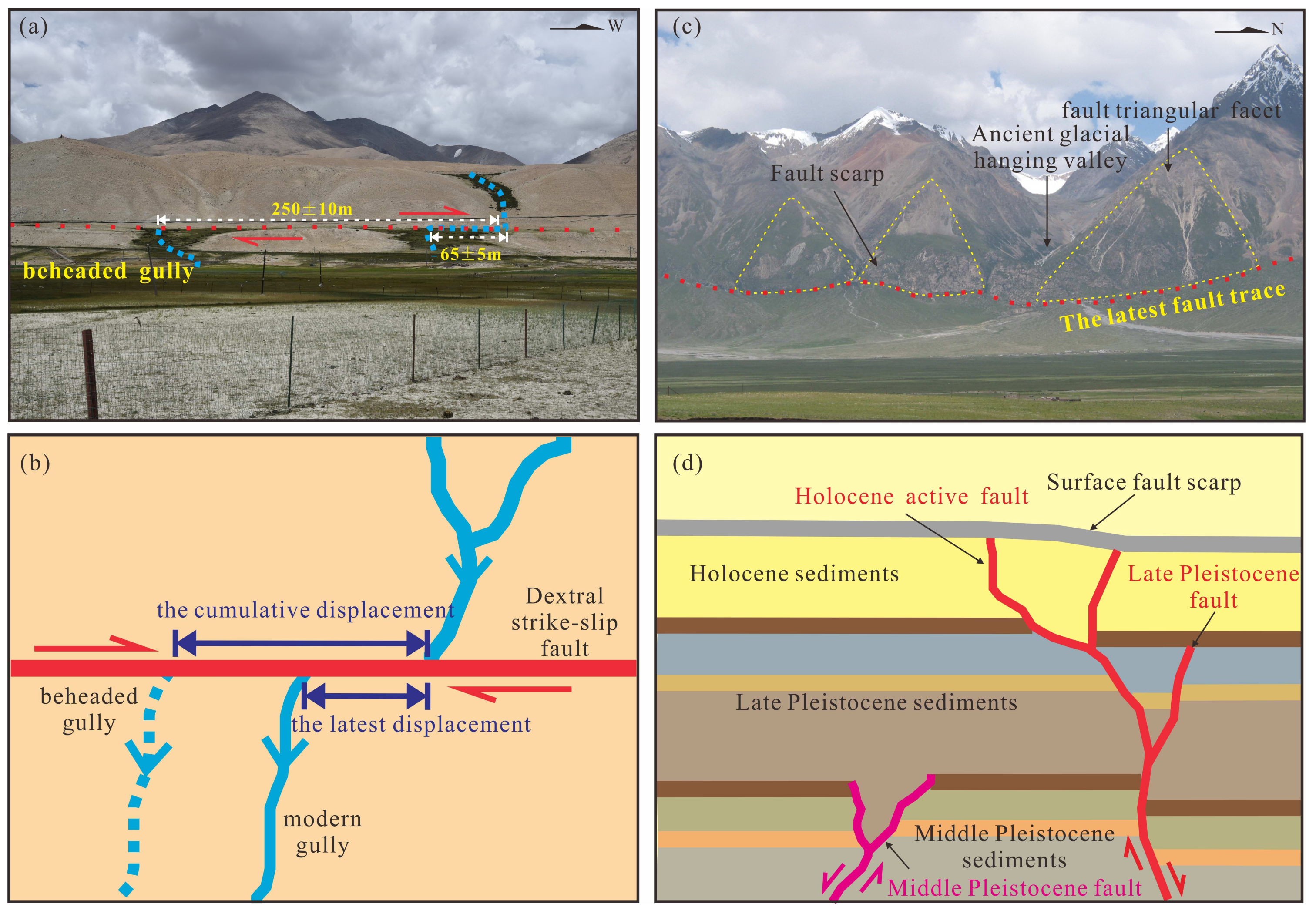
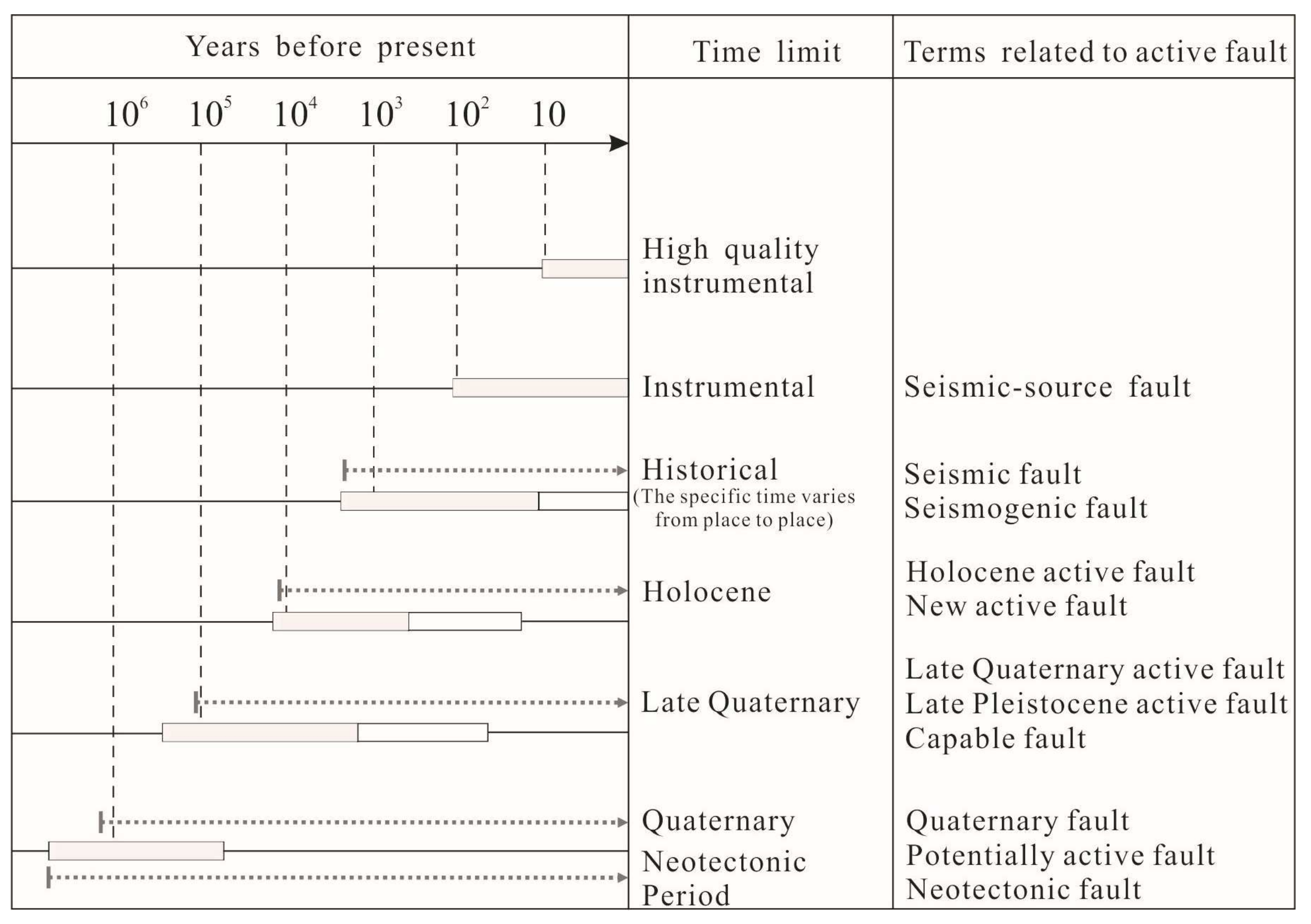
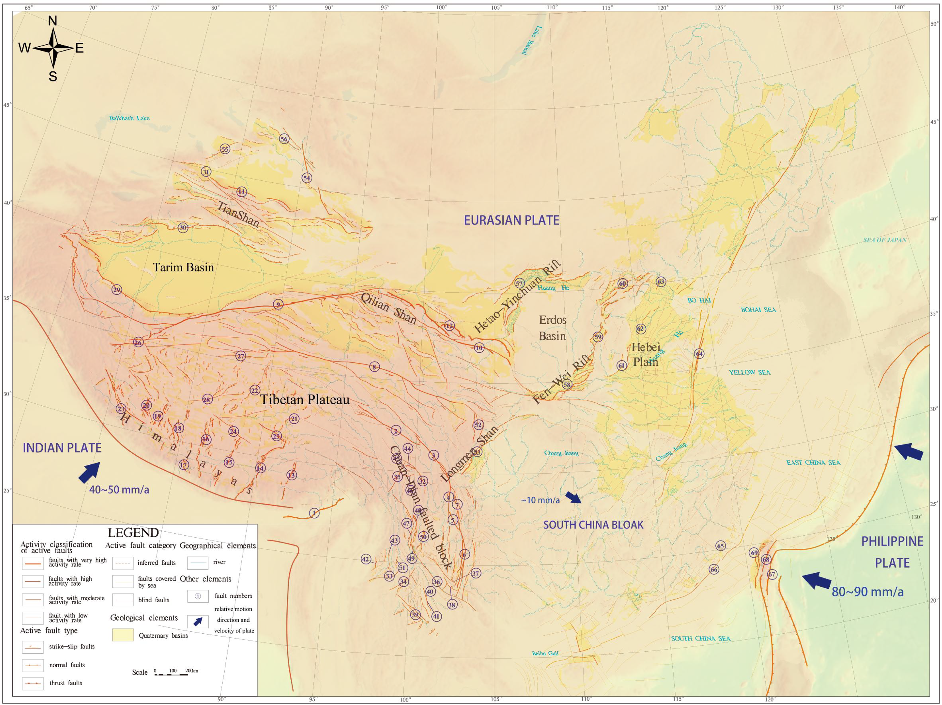
Table 1.
The related terms of active faults and their definitions and applications.
| Terms | Basic Definition and Its Main Application in Relevant Specifications and Guidelines | Reference |
|---|---|---|
| Active fault | The fault has been offset during the present seismotectonic regime and is likely to have renewed displacement in the future. Most, but not all, are seismogenic. The definition generally includes a time indication of either the most recent offset or a recurrence interval. | [17,18,19] |
| Active tectonics | The tectonic movements that have been moving during the late Quaternary (mainly the period from the present to about 500,000 years ago) concern society. | [27] |
| Neotectonics | The tectonic movements processing in Anthropogeny (Pliocene and Quaternary period, up till present), or processing since the formation of the current stress regime and tectonic-geomorphological framework. The key signature of the occurrence of neotectonic activity is the establishment of the current plate boundaries and kinematic images. | [30,31,32] |
| Neotectonic fault | The fault that has been active or causes earthquakes and surface deformation in the current stress regime of a region. The time period will vary from region to region. It is used in the “Global Neotectonic Fault and Fold Database”, and Australia’s “Neotectonic characteristics database”. | [23,33,34] |
| Quaternary active fault | The fault that has moved or shows geologic evidence of having been the source of large-magnitude, surface-deformation earthquakes (M > 6) in the last 1,600,000 years. It is used in the “US Quaternary Fault and Fold Database”. | [23,35,36] |
| Late Quaternary active fault | A fault whose movement in the past 130,000 years has been large enough to break the ground surface, including the late Pleistocene active faults and Holocene active faults. Used in the guidelines for evaluating the surface rupturing risks of active faults in Utah and other places in the US, and active fault databases of Japan, Greece, New Zealand, and Taiwan. | [23,36] |
| Holocene active fault | A fault that has moved or produced displacement in the Holocene (generally about the past 10,000 years) has been large enough to break the surface. It is used in the Alquist-Priolo (AP) Special Investigation Zone Act of California, USA (also known as active fault avoidance act), and the guidelines for evaluating the surface rupturing risks of active faults in Utah and other places in the United States. Also, it occurred in the latest national standard of “the People’s Republic of China (PRC): the Active Fault Detection (GBT 36072-2018)”. | [4,23,37,38] |
| Capable fault | It is a subset of active faults, indicating the capacity to rupture the ground surface. From the frequency of activity, it has been displaced once during the last 35,000 years, or more than once during the last 500,000 years. It is used in the “Italy Hazards from Capable Faulting (ITHACA)” thematic database. | [8,39,40] |
| Potentially active fault | It is similar to the capable fault, showing potential for displacement and/or deformation at or near the ground surface, generally during the Quaternary time (last 1.6 million years). It is frequently found in California’s Active Fault Avoidance Act and the American Nuclear Society’s (ANS) regulatory guides on seismic risk, surface rupture, and deformation assessment. | [37,41,42] |
| Seismic fault | Faults that are related to earthquakes that have occurred, but may be long inactive. Used in the Database of Individual Seismogenic Sources (DISS) of Italy and China’s Code for Seismic Design of Nuclear Power Plants (GB/T 50267-97). | [43,44] |
| Seismogenic fault | Faults that are capable of generating earthquakes, formalizing the Seismogenic Source, where slip occurs, and where most seismic energy is released during an earthquake. Included in “Euro-Mediterranean Database of Seismogenic Faults (EDSF)”, and China’s Code for Geological Investigation of Hydropower Engineering (GB 50287-2016), etc. | [45,46,47,48] |
| Precaution fault | An active fault with a relatively high potential for a near future destructive earthquake. “Elapsed time of the last large earthquake” and “Chain reaction or triggering effect of strong earthquakes within the same fault zone” are two important criteria for judging them. | [20,49] |
| Hazardous fault | A fault with a relatively high risk of potential strong earthquakes in the future. The elapsed time of the latest surface rupturing event approaches or exceeds the average interval of recurrent surface faulting. | [4] |
| Blind fault | The fault that does not directly reach the ground surface, may as well be capable of deforming the ground surface, and can even activate secondary (sympathetic) ground rupturing along more superficial faults, not necessarily connected directly with the master fault. Appears in the relevant standards and specifications for the siting of nuclear power plants developed by the ANS, and the “Global Neotectonic Fault and Fold Database” of the Global Earthquake Model (GEM). | [34,39,42] |
| Buried or Concealed active fault | The fault overlain by Quaternary loose deposits and showing no remarkable traces, or the fault whose deformation traces are consistently overlain by later deposits after surface deformation. Appears in the ANS regulatory guides on seismic risk, surface rupture, and deformation assessment, and the National Standard of the “People’s Republic of China (PRC): the Active Fault Detection (GBT 36072-2018)”. | [38,41] |
Table 2.
Active fault classification schemes of the New Zealand Geological Survey Institute.
| Category | Definition of Criteria |
|---|---|
| I | Faults that have moved repeatedly in the last 5 ka, or have moved repeatedly in the last 50–5 ka and have moved at least once in the last 5 ka. |
| II | Faults that have moved repeatedly in the last 0.5 Ma–50 ka, or that have moved once in the last 50–5 ka and have moved at least once in the last 5 ka, or that have not moved in the last 5 ka but have moved repeatedly in the last 50–5 ka. |
| III | Faults that have not moved in the last 50–5 ka but have moved in the last 5 ka, or have moved once in the last 0.5 Ma–50 ka and once in the last 5 ka, or that have not moved in the last 5 ka but have moved repeatedly in the last 0.5 Ma–50 ka, or have moved once in the last 50–5 ka. |
| IV | Faults that have had no movement 5 ka B.P. but have moved once in the last 5 ka. |
Table 3.
The active fault classification scheme of engineering project construction field in America.
Table 3.
The active fault classification scheme of engineering project construction field in America.
| Classification Basis | Category | Activity Characteristics or Signs | Institutions and Sources | |
|---|---|---|---|---|
| Movement rate and level of geological–geomorphological significance | A | Rate greater than 1 m per 1000 years (high movement rate). | [19,55] | |
| B | Topographic indications give clear evidence of fault activity. | |||
| C | Undefined topographical evidence of fault activity. | |||
| D | Qualitative evaluation that lacks adequate geological evidence and quantitative data support for fault activity. | |||
| Risk levels based on their relationship with earthquakes | Active fault (in the narrow sense) | A fault “that has ruptured within the last 35,000 years”. According to the youngest faulted deposits, two subcategories of active faulting can be defined: Holocene active faulting and the latest Pleistocene active faulting. | [19,56] | |
| Potentially active fault | A fault that is Quaternary active (about 1,600,000 years B.P.), but whose “displacement history in the last 35,000 years is not known well enough to determine activity or inactivity”. Again, two subcategories can be defined: Quaternary active fault and pre-Quaternary active fault (faults that have not had displacement in the Quaternary but are likely to move again under the current tectonic stress field). | |||
| I | High-latency–defined as a fault with evidence of Holocene activity, such as ① faulting of Holocene deposits. ② Groundwater anomalies on a fault extending into a Holocene formation. ③ Small earthquakes along the fault. ④ Strong manifestation of a faulted terrain (e.g., displacement of the mountain spur, mountain ridge, or river valley, especially demonstrable fault disturbance or restriction on the Holocene terrain). | |||
| II | Low-latency–where evidence of fault activity similar to subtype I predominantly appears in the Pleistocene time, especially the early stage of the Quaternary (about 1 Ma). | |||
| Inactive fault | A fault structure that has neither indication of fault displacement or activity in the Holocene nor deluvial period (the period of relatively humid climate in the Western Hemisphere during the Pleistocene) nor significant movement in the Quaternary. | |||
Table 4.
Mean recurrence interval classification scheme for active faults.
| Type | Fault Recurrence Interval (FRI) |
|---|---|
| I | FRI ≤ 2.0 kyr |
| II | 2.0 kyr < FRI ≤ 3.5 kyr |
| III | 3.5 kyr < FRI ≤ 5.0 kyr |
| IV | 5 kyr < FRI ≤ 10 kyr |
| V | 10 kyr < FRI ≤ 20 kyr |
| VI | 20 kyr < FRI ≤ 125 kyr |
| Inactive | FRI > 125 kyr |
Table 5.
The active fault classification scheme of California Division of Safety of Dams Fault Activity Guidelines.
Table 5.
The active fault classification scheme of California Division of Safety of Dams Fault Activity Guidelines.
| Category | Activity Characteristics or Signs |
|---|---|
| Active fault (or active seismic source) | A fault “that has ruptured within the last 35,000 years”. According to the youngest faulted deposits, two subcategories of active faulting can be defined: Holocene active faulting and the latest Pleistocene active faulting. |
| Conditionally active fault (or conditionally seismic source) | A fault that is Quaternary active (about 1,600,000 years B.P.), but whose “displacement history in the last 35,000 years is not known well enough to determine activity or inactivity”. Again, two subcategories can be defined: Quaternary active fault and pre-Quaternary active fault (faults that have not had displacement in the Quaternary but are likely to move again under the current tectonic stress field). |
| Inactive fault | a fault whose inactivity “is demonstrated by a confidently located fault trace that is consistently overlain by unbroken deposits 35,000 years or older, or other characteristics indicating lack of displacement within the last 35,000 years”. |
Table 6.
Descriptive categories of active and capable faults and coseismic phenomena (ACF_x).
| Category (ACF_x) | Definition of the ACF_x | Explanatory Notes |
|---|---|---|
| ACF_a | Certain and Defined | The main surface and related coseismic phenomena are recognized as certain. This category includes secondary tectonic structures and transfer areas between distinct segments of ACF. |
| ACF_b | Uncertain | The elements comprising ACF and related coseismic phenomena cannot be mapped with certainty and/or in detail due to the absence of data or because they cannot be identified (transfer zones, gaps, erosion, sedimentary cover, etc.). |
Table 7.
Active fault classification schemes commonly used in the field of engineering geology in China.
Table 7.
Active fault classification schemes commonly used in the field of engineering geology in China.
| Classification Basis | Category or Level | Definition or Criteria (or Indexes) |
|---|---|---|
| Time and mode of activities | Holocene active fault | A fault that has had relatively strong seismicity in the modern geological period (in the last 10,000 years) or has moved recently and is likely to continue to move in the future (the next 100 years). |
| Seismogenic fault | A fault that has produced M ≥ 5.0 earthquakes in the recent period (about the last 500 years) or can produce M ≥ 5.0 earthquakes in the next 100 years to come. | |
| Non-Holocene active fault | A fault that has had movement about 10,000 years B.P. but has not had any movement in the past 10,000 years. | |
| Activity intensity | Strong Holocene active faults | Faults with an average movement rate greater than 1 mm/yr have caused M ≥ 7 strong earthquakes. |
| Medium Holocene active faults | Faults with an average movement rate greater than 0.1 mm/yr but smaller than 1 mm/yr have caused M6~M7 strong earthquakes. | |
| Weak Holocene active fault | Faults with an average movement rate smaller than 0.1 mm/yr and have caused M < 6 earthquakes. |
Table 8.
The classification scheme of active faults developed by the International Lithosphere Program’s “Task Group II-2 Project on Major Active Faults of the World”.
Table 8.
The classification scheme of active faults developed by the International Lithosphere Program’s “Task Group II-2 Project on Major Active Faults of the World”.
| Region | Initial Scheme | Western Hemisphere | Eastern Hemisphere | ||||
|---|---|---|---|---|---|---|---|
| Basis | Name | Time Limit | |||||
| Last Activation Time | Historical active fault (1) | <200 yr–2000 yr | <150 yr | Adopted | |||
| Holocene active fault | <10 ka | End of late Pleistocene–Holocene active faults | <15 ka (2) | Late Pleistocene–Holocene active faults | <100 ka | ||
| Late Quaternary active fault | <100–130 ka | <130 ka | |||||
| Middle–late Quaternary active fault (3) | <700–730 ka | <750 ka | Middle Pleistocene active faults | <0.7–1.0 Ma | |||
| Quaternary active fault | <1.6 Ma | <1.6 Ma | Not adopted | ||||
| Average Slip Rate (V) | Class I fault | V ≥ 5 mm/yr | V > 5 mm/yr | Adopted | |||
| Class II fault | 1 mm/yr < V < 5 mm/yr | 1 mm/yr ≤ V ≤ 5 mm/yr | |||||
| Class III fault | V ≤ 1 mm/yr | 0.2 mm/yr ≤ V ≤ 1 mm/yr | |||||
| Class IV fault (4) | — | V < 0.2 mm/yr | — | ||||
Note: (1) The time limit may vary depending on the historical records of the host countries or regions. (2) Faults that have been active since the postglacial period have been emphasized. (3) Faults that have been active since the middle Pleistocene have been emphasized. (4) The classification scheme adopted by the Western Hemisphere.
Table 9.
The classification scheme of active fault adopted by GEM “Global Neotectonic Fault Database”.
Table 9.
The classification scheme of active fault adopted by GEM “Global Neotectonic Fault Database”.
| Basis | The Last Activation Time | The Average Slip Rate (V) (mm/yr) | The Average Recurrence Interval (I) (kyr) | |||
|---|---|---|---|---|---|---|
| Category | Name | Time Limit | Name | Rate | ||
| I | Historical and recent 1 ka | 0~1000 yr B.P. | Very high | 100 ≤ V < 200 | 0.01 ≤ I < 0.1 | |
| II | Holocene | 1~11.7 ka B.P. | 50 ≤ V < 100 | 0.1 ≤ I < 1.0 | ||
| III | Late stage of late Pleistocene | 11.7~50 ka B.P. | 10 ≤ V < 50 | 1 ≤ I < 2 | ||
| IV | Early stage of late Pleistocene | 50~100 ka B.P. | High | 5 ≤ V < 10 | 2 ≤ I < 5 | |
| V | End of the early Pleistocene to the beginning of the late Pleistocene | 100~1.0 Ma | Moderate | 1 ≤ V < 5 | 5 ≤ I < 10 | |
| VI | Late stage of the middle Pleistocene to the end of early Pleistocene | 1~10 Ma | Low | 0.1 ≤ V < 1 | 10 ≤ I < 100 | |
| VII | — | — | Very low | 0.01 ≤ V < 0.1 | 100 ≤ I < 500 | |
| VIII | — | — | 0.001 ≤ V < 0.01 | 0.5 Ma ≤ I < 1.0 Ma | ||
| IX | — | — | — | 1 Ma ≤ I < 10 Ma | ||
Table 10.
The representative age classification scheme for active faults.
| Last Activation Time | Definition |
|---|---|
| Historical | Faults with surface dislocation in history (since 150 years ago). |
| Holocene (early scheme) Late Pleistocene to Holocene (new scheme) | A fault whose movement in the Holocene (about the past 10,000 years) has been large enough to break the ground surface. A fault whose movement from late Pleistocene to Holocene (in the past 15,000 years) has been large enough to break the ground surface. |
| Late Quaternary | A fault whose movement in the past 130,000 years has been large enough to break the ground surface. |
| Mid-Late Quaternary | A fault whose movement in the past 750,000 years has been large enough to break the ground surface. |
| Quaternary (undivided) | A fault whose movement in the past 2,600,000 years has been large enough to break the ground surface. |
| Uncertain time | Similar to potentially active fault |
Table 11.
The active fault classification scheme of the European Union “in Europe-the Mediterranean seismogenic fault database”.
Table 11.
The active fault classification scheme of the European Union “in Europe-the Mediterranean seismogenic fault database”.
| Level | Name | Slip Rate Value = V (mm/yr) |
|---|---|---|
| I | Very high rate | 10 ≤ V < 50 |
| II | High rate | 5 ≤ V < 10 |
| III | Moderate rate | 1 ≤ V < 5 |
| IV | Low rate | 0.5 ≤ V < 1 |
| V | 0.1 ≤ V < 0.5 | |
| VI | Very low rate | 0.05 ≤ V < 0.1 |
| VII | 0 < V < 0.05 |
Table 12.
The active fault classification scheme used in Japan active fault mapping.
| Fault Accuracy | Fault Activity (or Activity Intensity) | ||
|---|---|---|---|
| Category | Categorization Criteria | Level | Slip Rate Value = V (mm/a) |
| I | Faults with confident evidence of Quaternary movement, are usually easy to determine using remote sensing images or aerial photos. | AA | 10 ≤ V < 100 |
| II | Suspected active faults are faults whose movement direction and displacement can be inferred but lack high-confidence data or evidence of Quaternary movement. | A | 1 ≤ V < 10 |
| III | Possible active faults are suspected to have had Quaternary movement due to the existence of demonstrable linear traces on the ground surface but there is the possibility that these linear structures are topographic remnants produced by river or sea erosion or along-the-fault erosion. | B | 0.1 < V ≤ 1.0 |
| — | — | C | 0.01 ≤ V < 0.1 |
| — | — | D | V ≤ 0.01 |
Table 13.
Four faults defined in the “Seismotectonic Map of China and Its Adjacent Areas (1:4,000,000)”.
Table 13.
Four faults defined in the “Seismotectonic Map of China and Its Adjacent Areas (1:4,000,000)”.
| Categories | Definition |
|---|---|
| Holocene active fault | An active fault that produced displacement in the Holocene time. |
| Late Pleistocene active fault | An active fault that has faulted late Pleistocene deposits, geological, or geomorphological units but has no evidence of Holocene activity. |
| Early-Middle Pleistocene fault | A fault that has faulted early to mid-Pleistocene deposits, geological, or geomorphological units but has no evidence of activity since the late Pleistocene. |
| pre-Quaternary fault | A fault that has been inactive since Quaternary. |
Table 14.
The classification scheme of active faults with degree of activity developed by the newly compiled “Distribution Map of Active Faults in China and Its Adjacent Sea Areas” (1:5000,000) (after Wu and Zhou, 2018 [1]).
Table 14.
The classification scheme of active faults with degree of activity developed by the newly compiled “Distribution Map of Active Faults in China and Its Adjacent Sea Areas” (1:5000,000) (after Wu and Zhou, 2018 [1]).
| Activity Level | Main Indexes | Overall Characteristics | |||||
|---|---|---|---|---|---|---|---|
| No. | Name | Geomorphic Display Degree | Deformation Rate (R)/(mm/yr) | In-Situ Recurrence Interval of M ≥ 7.0 Earthquake (T)/(kyr) | |||
| Strike-Slip Fault | Normal Fault | Reverse Fault | |||||
| AA | Very strong | Particularly significant | R > 15.0 | R > 2.0 | R > 10.0 | T ≤ 0.5 | The faults constitute boundaries of plates or large active blocks/fault blocks and feature large size, good regional continuity, high slip rate, and strong earthquake frequency. |
| A | Strong | Significant | 5 ≤ R < 15 | 0.5 ≤ R < 2.0 | 2 ≤ R < 10 | 0.5 < T ≤ 2.5 | The faults often constitute boundaries of large intraplate active blocks/fault blocks and feature large size, good regional continuity, relatively high slip rate, and strong earthquake frequency. |
| B | Moderate | Relatively significant | 0.5 ≤ R < 5.0 | 0.1 ≤ R < 0.5 | 0.2 ≤ R < 2.0 | 2.5 < T ≤ 10 | The faults are often intraplate faults, of which some constitute boundaries of moderate to large active blocks/fault blocks, and feature moderate or relatively large size, relatively good regional continuity, moderate slip rate, and strong earthquake frequency. |
| C | Weak | Average | R < 0.5 | R < 0.1 | R < 0.2 | 10 < T | The faults often lie inside active blocks/fault blocks and feature relatively small size, poor regional continuity, low slip rate, and the ability to induce destructive earthquakes. However, strong earthquake frequency is low. |
Note: Here, the deformation rate indexes for strike-slip faults, normal faults, and reverse faults are for cross-fault strike-slip rate, vertical slip rate, and horizontal shortening rate, respectively. A strong earthquake is defined as M ≥ 6.0.
Table 15.
Proposed definitions and terminology of active faults in the engineering field.
| Term | Basic Definition | Characteristics and Parameters of Active Faults to Be Identified in Engineering Survey |
|---|---|---|
| Engineering active fault | Faults with possible surface deformation or M ≥ 5.0 earthquake during the project life (about 100 years in the future), especially those active repeatedly since 750,000 years ago (since the middle Pleistocene) or about 130,000 years ago (from the late Pleistocene to the Holocene). |
|
| Hazardous fault (or Precaution fault) | Faults with a high risk of activity during the project life, generally those with the elapsed time of the last surface deformation (or major earthquake) approaching or exceeding its average recurrence interval. | |
| Surface active fault | Active faults that can cause surface or near-surface deformation (including folds, etc.). | |
| Seismic fault (or Seismogenic fault) | Faults relating to earthquakes that have occurred or forming the seismogenic source and controlling the occurrence of future earthquakes. |
|
Table 16.
Hazard degree classification of active faults and related prevention advice in engineering.
Table 16.
Hazard degree classification of active faults and related prevention advice in engineering.
| Degree | Determining Criterion | Characteristics | Prevention Advice in Engineering |
|---|---|---|---|
| High | Te ≈ Tr or Te > Tr | The elapsed time of the last surface deformation or large earthquake of the fault (Mw ≥ 6.5) has been very close to or exceeds the average FRI, and the probability of surface deformation or major earthquake occurring again within the project life is very high. | Projects with high safety requirements (such as dam sites and nuclear facilities) must be avoided, and other projects should be avoided as much as possible. When linear projects cannot be avoided, fault deformation concentrated section or weak deformation section can be selected to cross with low-cost simple projects. |
| Middle | Te > Tr × 50% and Te < Tr × 80% | The elapsed time of the last surface deformation or large earthquake (Mw ≥ 6.5) of the fault exceeds 50% of the average FRI but is less than 80%. There is still the possibility of surface deformation or major earthquakes occurring again within the project life. | |
| Low | Te < Tr × 50% and Te > Tr × 20% | The elapsed time of the last surface deformation or large earthquake (Mw ≥ 6.5) is less than 50% of the average FRI, but more than 20% of it. The probability of surface deformation or large earthquakes occurring again within the project life is low. | Projects with high safety requirements can be avoided, and other projects cannot consider the impact of fault activity. |
| Extremely Low | Te < Tr × 20% | The fault has just experienced a surface deformation or a large earthquake (Mw ≥ 6.5) recently (within a hundred years), or its elapsed time is less than 20% of the average FRI, which can exclude the possibility of surface deformation or a large earthquake occurring again within the service life of the project. | The influence of fault activity may not be considered. The fault can be treated as a general fault fracture zone or weak zone. |
Note: Te refers to the age of the last surface deformation or the age of the last large earthquake; Tr refers to the average fault recurrence interval (or earthquake recurrence interval).
Disclaimer/Publisher’s Note: The statements, opinions and data contained in all publications are solely those of the individual author(s) and contributor(s) and not of MDPI and/or the editor(s). MDPI and/or the editor(s) disclaim responsibility for any injury to people or property resulting from any ideas, methods, instructions or products referred to in the content. |
© 2024 by the authors. Licensee MDPI, Basel, Switzerland. This article is an open access article distributed under the terms and conditions of the Creative Commons Attribution (CC BY) license (https://creativecommons.org/licenses/by/4.0/).
Share and Cite
MDPI and ACS Style
Wu, Z.; Hu, M. Definitions, Classification Schemes for Active Faults, and Their Application. Geosciences 2024, 14, 68. https://doi.org/10.3390/geosciences14030068
AMA Style
Wu Z, Hu M. Definitions, Classification Schemes for Active Faults, and Their Application. Geosciences. 2024; 14(3):68. https://doi.org/10.3390/geosciences14030068
Chicago/Turabian StyleWu, Zhonghai, and Mengmeng Hu. 2024. "Definitions, Classification Schemes for Active Faults, and Their Application" Geosciences 14, no. 3: 68. https://doi.org/10.3390/geosciences14030068
Note that from the first issue of 2016, this journal uses article numbers instead of page numbers. See further details here.