1. Introduction
The representation of the landscape and the natural environment in paintings has been present since the Egyptian civilization and has developed until today through defined and representative periods [
1]. However, when we talk about physical landscape proper in painting, we generally mean that artistic production that established itself between 1400 and 1500 in Italy, Holland, and then in England, determining its definition and autonomy [
2]. The need of the clients to immortalize their territories as backdrops for their portraits or in religious representations determined the proliferation of extensive real landscapes using the perspective techniques that were emerging through the study of topography and mathematics. Many great Renaissance painters were in fact also mathematicians, naturalists, and topographers. The meaning of the real and scientific restitution of the landscapes in the paintings therefore becomes a cultural reason to immortalize the client. This motivation, however, was lost over time and subsequently only a few scholars understood that the recognition of the real landscape, performed in such a precise way, could also be a tool for understanding the evolution of the physical and anthropic landscape and becoming a cultural landscape.
The planning and elaboration of a Renaissance painting cannot therefore consider the landscape as a simple background, a mere complement to a foreground; on the contrary, it becomes an inseparable and unitary part of it. There is no predefined rule in this regard; each artist developed a different modus operandi according to his own culture and inclination. For example, Piero della Francesca adapted his pictorial art to the need for precise and timely territory representation according to innovative principles of scientific cartography (aerial perspective, projection on a plane, emerging reliefs such as trigonometric points). Many art scholars have tried identifying the landscapes in Piero della Francesca’s paintings [
3]. They range from a generic view of Federico da Montefeltro’s dominions [
4], up to real recognitions [
5], including the Metauro Valley. Other studies reconnect the landscape of the Diptych of the Dukes to the Val di Chiana and Lake Trasimeno with Maggiore Island [
6]. Attilio Brilli, in 1991, intuits for the first time the location of these backgrounds by stating: “These are landscape views whose enchantment we have already discovered on arriving in Urbino from Urbania, via the Capute road and Mount Spadara, and which we will find again in Montefeltro, towards the Foglia and Metauro Valleys” [
7]. The author quotes the poet Caldarelli who understood the depiction of the land of Urbino behind the Portraits of the Dukes and behind their Triumphs, looking at it from above, like a precious geographical relief. Many other authors [
8,
9,
10], extolling the genius of the painter, relate the resolute character of Federico in the foreground to the gentle background, “that of the Urbino hills, to soften the character”. However, other studies only indicate a “harsh landscape of black or yellowish mounds and puddles of clear water” [
11].
Leonardo da Vinci dedicated much of his life to the study of nature. Noteworthy are the geological and paleontological studies conducted near his hometown, Vinci, and the detailed geological and sedimentological structures depicted in his paintings [
12,
13]. Leonardo is also known as a geographer and cartographer; he made many maps of the places he visited, for the purpose of study and for his patrons. Accurate drawings show how he knew the natural processes, in rivers and on slopes. We recall the geographical maps of Tuscany, embellished with numerous toponyms, and the map of the city of Imola, a work of art for accuracy and detail. There are many drawings, cataloged as “unknown landscapes” which have never been precisely (or sometimes incorrectly) identified because they lack toponyms. However, these drawings have unmistakable geomorphological features, and only those who study the physical landscape can understand the details. Moreover, it is essential to know the climatic, tectonic, and anthropic changes that have affected the landscape. Leonardo, based on empirical notions observed directly on the ground, experimented with a bold and revolutionary representation of relief, separating perspective planes, not only with color but compressing them and sometimes deforming them in a kind of anamorphosis to give a greater sense of relief and depth. Leonardo “constructed” an intermediate representation between the drawing of the real landscape and the topographical plan in a bird’s eye reinvention and synthesized the view of perspective space and the measurement of distances [
14]. Several authors have tried to study Leonardo’s landscape, but often without using a geomorphological approach that considers the evolution of the landscape and its representation. On the landscape of the Gioconda we should mention the study of Starnazzi [
15] and some other significant insights [
16,
17].
Raphael’s perception of landscape is significantly different. It can be said that with Raphael, the landscape, although real and recognizable, partly ceases to be a topographic and/or scientific representation of a place. Raphael’s landscapes speak of nature and beauty; they leak with love for their land, revealing ties and memories. The attachment to his land was truly strong as, indeed, still happens today to those who are born and grow up in this place. Although the life and works of Raphael, in their artistic, historical, and human aspects, have been rigorously examined by scholars from all over the world, there has not yet been a thorough study of the landscape. The natural environment in Raphael’s paintings, in fact, is described only from an aesthetic and symbolic point of view [
18]. The reproduction of the places of his native land undergoes a mental metamorphosis, a perceptive interpretation of natural forms that nevertheless retain their morphological rigor and are, therefore, perfectly recognizable in the current landscape.
The Duchy of Urbino (1443–1631) was an ancient state in central Italy of feudal origin and linked to the Papal State. Located on the hills in the northern Marche Region, Urbino experienced an extraordinary cultural development in the 15th century: it attracted artists and scholars from all over Italy and abroad, who influenced cultural developments in many other parts of Europe.
The territory of the Duchy of Urbino is characterized by an extraordinary cultural heritage that includes historical, archaeological, architectural, and natural heritage [
19]. The latter is primarily associated with landscapes of great aesthetic appeal. The great artists of the Renaissance who used to frequent these areas were deeply impressed. Piero della Francesca, Raphael, and Leonardo were particularly interested in these landscapes, so much so that they reproduced them in their most famous works.
This paper aims to report to the international scientific community the results of several projects on the landscapes of these areas developed over the past 15 years, landscapes that have been recognized in paintings by famous Renaissance authors. A map presents the observation sites from which the landscapes were reproduced. In detail, this study will examine three very famous works depicting different morphologies of the territory of the Duchy of Urbino, in the backgrounds painted by three great artists: “Nativity” by Piero della Francesca, “Madonna Litta” by Leonardo da Vinci, and “Knight’s Dream” by Raphael.
In 1992, the World Heritage Convention became the first international legal instrument to recognize and protect cultural landscapes. The guidelines for their inclusion on the World Heritage List start from the premise that cultural landscapes represent “the combined work of nature and man”. Cultural landscapes encompass several categories, including landscapes depicted in art, sometimes modified by geomorphological processes or by direct or indirect human action.
Starting from the geological and geomorphological description of the area, this paper has the following objectives:
describe a pioneering method that applies modern scientific technologies in art.
reconstruct, through a paleo-geographic study, the morphologies of the depicted areas at the time of their representation.
accurately identify the “viewpoints” from which the authors portrayed such landscapes.
illustrate multi-year projects focused on enhancing and popularizing art landscapes in the Duchy of Urbino.
make these landscapes timeless by including them in UNESCO’s cultural heritage landscapes.
2. Geographical Boundaries and Geological Setting of the Area
The Duchy of Urbino extended mainly in the northern part of the present Marche Region, in the provinces of Pesaro and Urbino (except the city of Fano), and part of the province of Ancona. It also included some municipalities of the Upper Marecchia Valley, in the Emilia-Romagna Region, and some municipalities in the Upper Umbria Region.
The birth of the Duchy of Urbino dates to 1443, following the nomination by Pope Eugene IV of Oddantonio II da Montefeltro as Duke of Urbino. Between 1444 and 1482, Federico da Montefeltro, Duke of Urbino, brought together in his court many of the great figures of the time: foremost humanists of the time such as Leone Battista Alberti, Marsilio Ficino, and Giovanni Bessarione; mathematicians like Paul van Middelburg; and artists such as Luciano Laurana, Francesco di Giorgio Martini, Paolo Uccello, and Ambrogio Barocci. This flourishing climate allowed Raphael, Donato Bramante, Piero della Francesca, and mathematician Luca Pacioli, natives of these lands, to thrive in their art and science. The state had the city of Urbino as its capital until 1523, which soon became one of the focal centers of the Italian Renaissance. From 1523 until the extinction of the duchy in 1631, the capital was moved to the larger and neighboring city of Pesaro.
The Duchy of Urbino did not produce official maps [
20]. However, this territory has numerous cartographic documents, one shown in
Figure 1. The oldest is that of G.B. Clarici (c. 1570), which provided interesting indications of rivers, reliefs, and toponyms [
3]. However, the geographical limits were not well defined, and in general, the boundary of the duchy had to be guessed due to inaccuracies in the drawing.
At the time of Duke Guidobaldo (1472–1508), the duchy of Urbino included parts of what is now southern Romagna, much of northern Marche, and a small part of the Umbria Region, roughly as far as the city of Gubbio. The coast belonged to the Malatesta family, which by the 15th century had conquered the towns of Pesaro, Fano, and Senigallia [
21].
The Duchy of Urbino, therefore, extended into the north-central Apennines and was geologically constituted by the formations of the Umbro-Marchean Succession in the southernmost part and by allochthonous and semi-allochthonous deposits belonging to the Valmarecchia Nappe in the northernmost sector.
A schematic evolutionary framework is given below to shed light on the main geological and geomorphological features of the area.
The Umbro-Marchean Apennine chain is an arc-shaped fold and thrust belt with northeastward vergence, forming the external portion of the Central-Northern Apennines. The Umbro-Marchean Succession consists of sedimentary formations deposited from the Jurassic period (about 201 million years ago) to the Pleistocene (about 2.5 to 0.01 million years ago). Owing to its completeness and continuity, the Umbro-Marchean Succession is one of the most studied stratigraphic series worldwide. Very schematically, there is a basal not-outcropping sequence [
22], related to shallow-water marine sedimentary environments (Upper Triassic, about 237 to 201 million years ago), a pelagic environment sequence (Jurassic–Eocene, about 201 to 33 million years ago), and a mainly turbiditic upper sequence (Upper Oligocene–Upper Miocene, about 28 to 12 million years ago) [
23].
In the Upper Triassic, a large shallow-water evaporitic basin was in the Umbro-Marchean area. In the Late Triassic, significant climatic changes occurred, signaled by the disappearance of evaporitic sediments, which were substituted by limestone–clay sediments, and in the Lower Jurassic, carbonate platform sedimentation began. Since the end of the Lower Jurassic (about 180 million years ago), in conjunction with an extensional tectonic phase, the platform broke into several blocks, forming horsts and graben. The shallow sea sedimentation ended, and a persistent pelagic sedimentation began, thus leveling such horst and graben physiography. A sediment of considerable thickness was deposited in the deepest basins (between 1000 and 1500 m depth) [
24,
25], producing a complete stratigraphic succession. In the uplands, characterized by shallow waters, thinner sediments and/or gaps that vary in time were formed, originating condensed or incomplete succession.
The orogenic process started in the Early Miocene and first affected the inner part of the northern Apennines. The deformation of the forehead was accompanied by the formation of large tectonic depressions (“foredeeps”), where massive turbiditic successions accumulated. The Apennines’ formation proceeded through the migration of the chain system toward the NE; during this migration, the Umbro-Marchean basin lost its uniformity and bent.
In the Late Miocene (in the Messinian, about 7.2 to 5.3 million years ago), the Mediterranean Sea became isolated from the Atlantic Ocean. It began to dry up, changing from a pelagic to an evaporitic environment. During the Upper Messinian, the Apennines emerged, and a lake–sea environment formed in the inner Marchean basin. With the Pliocene marine ingression, a pelagic environment was reestablished with predominantly arenaceous pelite and turbidite deposition. During the Pliocene (about 5.3 to 2.6 million years ago), the orogenesis reached its peak; the Marchean basin was subjected to great compression with uplift of the sedimentary deposits, and a series of eastward folds and overthrusts formed [
26,
27,
28]. The deformation and emersion of the chain persisted until the Quaternary period, and, concomitantly, the area was shaped by exogenous agents on different lithotypes [
29], producing the present-day, highly articulated, and suggestive scenario, characterized by extraordinary geodiversity [
30,
31].
The lithostratigraphic and structural setting has conditioned the arrangement of the river network, which shows an overall sub-parallel trend, oriented predominantly SW–NE, crossing the main anticlinal ridges towards the Adriatic Sea [
32].
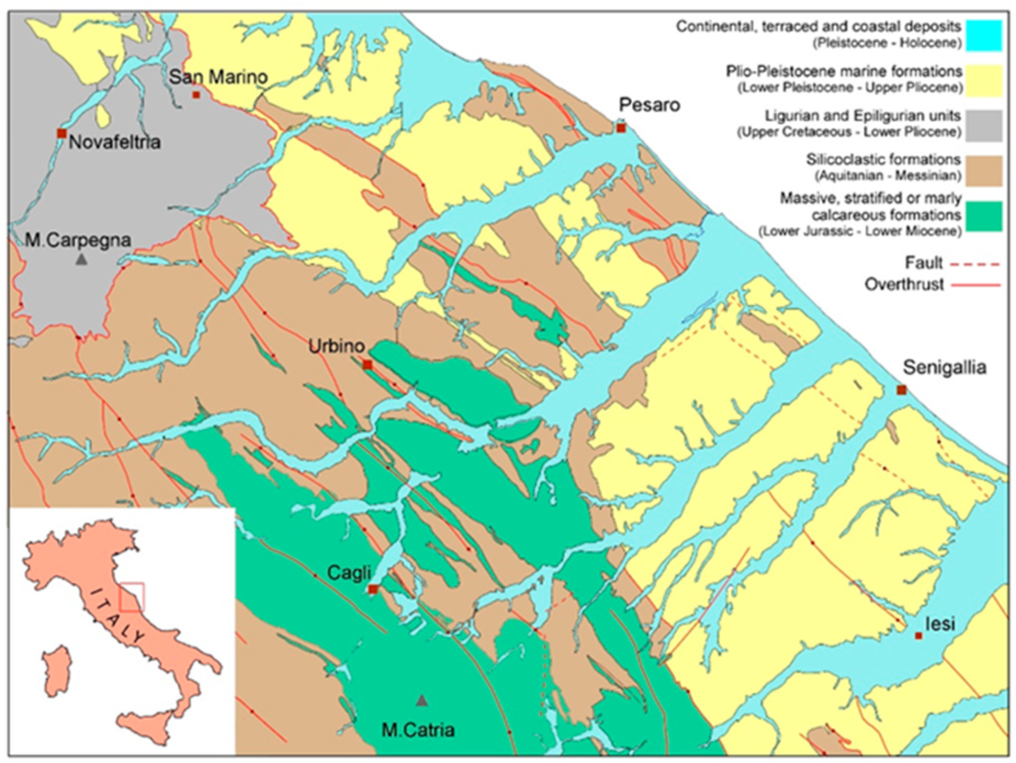
Figure 2 shows a simplified geologic sketch that summarizes the Umbro-Marchean formations into four major groups:
Jurassic–Oligocene formations of the carbonate ridges, massive, stratified, or marly-limestone formations.
Miocene marly-limestone, terrigenous, and evaporitic formations.
Plio-Pleistocene marine formations.
Upper Cretaceous–Lower Pliocene Ligurian and Epiligurian Units.
The Cretaceous–Pliocene formations of the last group crop out in the northernmost sector of the area and pertain to the so-called “Valmarecchia Nappe”. These formations originate from the Ligurian–Piedmontese basin and overlap the Umbro-Marchean Succession through both tectonic and gravitational mechanisms [
33,
34]. The strong lithological contrast between the mainly clayey Ligurian Units and the more rigid, predominantly Epiligurian limestone blocks on top [
35,
36,
37] has been responsible for a unique and fascinating landscape but, at the same time, it is fragile and unstable.
The Epi-Ligurian Units (Langhian–Messinian) include a wide variety of lithotypes varying from conglomerates, sandstones, and biocalcarenites to gypsum, marls, and clays. The Ligurian Units, in turn, are represented by the Pietraforte–Alberese succession (Maastrichtian–Eocene), where chaotic varicolored shales are accompanied by more competent lithotypes such as limestones, marly mudstones, and sandstones to form a typical mélange.
Although the two quite different geological–geomorphological domains of the autochthonous Umbria–Marche fold-and-thrust chain and of the allochthonous Valmarecchia Nappe experienced the same climatic conditions and were subjected to similar morphogenetic agents and processes, very different landforms were produced due to a strong structural constraint. As a result, the two domains give rise to significantly different landscapes, which, in addition to impressive natural sceneries and amazing landforms, are matters of great scientific and educational significance. The autochthon is characterized by well-developed anticline ridges, bearing outliers and structural surfaces of different types, flanked by a series of “flatirons” and crosscut by deep gorges. In contrast, the Valmarecchia Nappe landscape is constituted by isolated rocky reliefs and spurs that protrude from badlands and gentle hillslopes affected and shaped by extensive mass movements.
3. Materials and Methods
Nowadays, there is a great deal of attention in research that addresses the fundamental concepts of geodiversity, geoheritage, and geotourism; such research is widespread in every cultural field, involving a wide variety of places, disciplines, languages, and methods [
38,
39,
40,
41,
42,
43,
44,
45,
46,
47,
48,
49,
50,
51,
52,
53,
54,
55,
56,
57,
58,
59].
The study of backdrops in artworks by the Renaissance painter Piero della Francesca should be considered pioneering for applying the following analytical approach. The method was developed and consolidated gradually, following an intuition linked to a detail of one of Piero’s most important paintings. Starting from this detail of the backdrop, which was recognized and precisely located in the territory of the Duchy of Urbino, a path of reconstruction was followed, the result of a thorough knowledge of the territory, as well as a consolidated memory of the landscapes depicted in the author’s paintings.
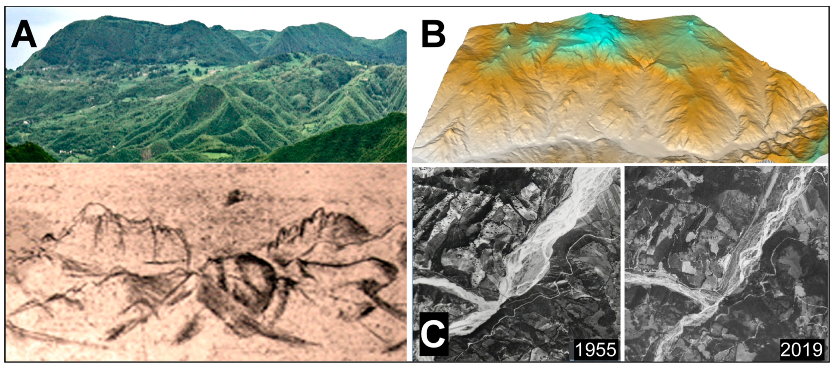
Among the various disciplines involved in the developed methodological approach, geomorphology contributes most to the recognition of natural elements (
Figure 3A). Systematic analysis of the factors that have shaped and changed the land, such as geological history, climate, and man, forms the basis for understanding the artistic representation of the landscape.
Many great Renaissance artists defined a new conception of the painted landscape, based not only on the aesthetic depiction of the area of interest but also on the analysis and understanding of the painted landscape. Such artists were not only extraordinary draughtsmen but also refined naturalists who wondered about natural processes and consequently were able to reproduce landscape forms with knowledge, intuiting the natural laws (erosion, transport, sedimentation) that had produced that landscape. Considering that these artists, especially portrait painters, depicted the backgrounds with extreme faithfulness, as though they were “photographs” and according to the wishes of their patrons, the artwork takes on the importance of an authentic historical document, the only evidence of the ancient morphology of the territories related to the characters depicted [
20,
60].
The methodology used to survey and reconstruct landscapes is based primarily on an image analysis process that works on both the picture and the actual landscape. Thanks to software graphics, each detail in the area can be investigated with accuracy, allowing color and morphological differences to be highlighted and improving the resolution of details in paintings. As a result, landforms and/or topographic profiles can thus be identified, which in some cases can be overlapped, highlighting any changes over the centuries. Digital elevation models are used to visualize landforms from various altitudes and angles to precisely find the points of view from which the artist captured his background. Moreover, the vegetation and the anthropic forms are not visible in the Dems and therefore the forms of the relief, being more evident, can be analyzed in detail (
Figure 3B). Geomorphological analysis in the field, combined with the study of aerial, drone, and satellite images (
Figure 3C) and coupled with paleoclimatic and geoarchaeological investigations, provides insight into the evolution of the landscape over time. It may happen that some geomorphological features (landslides, lakes, floods) are not present in the landscape of the painting and, on the contrary, are present in the current landscape due to successive, significant climatic and/or anthropic variations. Back-analysis is a very delicate and important phase in our study approach and aims to correlate diachronic forms of the same landscape. The processes of slope and river erosion are therefore taken into account because they significantly alter the landscape, in particular through extreme events, which often lead to sudden changes in morphology [
60,
61]. In addition, the vegetative cover and its nature, which often change over the centuries, are extremely relevant morphodynamic factors and should always be considered as possible causes or consequences of morphological changes over time.
The importance of using a multidisciplinary method should be emphasized, examining the historical aspects related to the territory, biographies of artists, documents of the patrons of the works, mathematical and ecological elements, and data relating to the evolution of the environment, which help to understand the landscapes in their representation thoroughly.
Enhancement and Popularization of Art Landscapes
The project “The Invisible Landscape: The Real Landscapes of Piero della Francesca” started in October 2007 with the recognition of the landscape as the background of the portrait of Federico da Montefeltro in the famous Diptych of the Dukes of Urbino by Piero della Francesca [
20].
There were two roads in the ancient Duchy of Urbino that Piero traveled along from his hometown of Sansepolcro in neighboring Tuscany to reach his patrons in the cities of Urbino and Rimini: the Montefeltro and Malatesta. The first road, with Tuscany behind him, runs along the Metauro River Valley as far as Urbino. The second one included two possible alternatives depending on the season: he could either proceed along the Marecchia River Valley as far as Rimini or take the road on the ridge of the watershed between the regions of Tuscany, Marche, and Romagna to the Adriatic Sea.
The landscape near Urbino is recognizable by the unmistakable morphology of its hills, which softly merge into each other. The Marecchia Valley landscape, on the other hand, is famous for its rugged limestone cliffs, pinnacles, and spires that appear everywhere along the valley.
It was along these two routes that the painter captured the locations for the backgrounds of seven of his extraordinary works: Diptych of the Dukes of Urbino (portraits of Federico, Battista, the Triumphs; [
20,
60]); Saint Jerome and a Donor; Nativity; The Baptism of Christ; Resurrection.
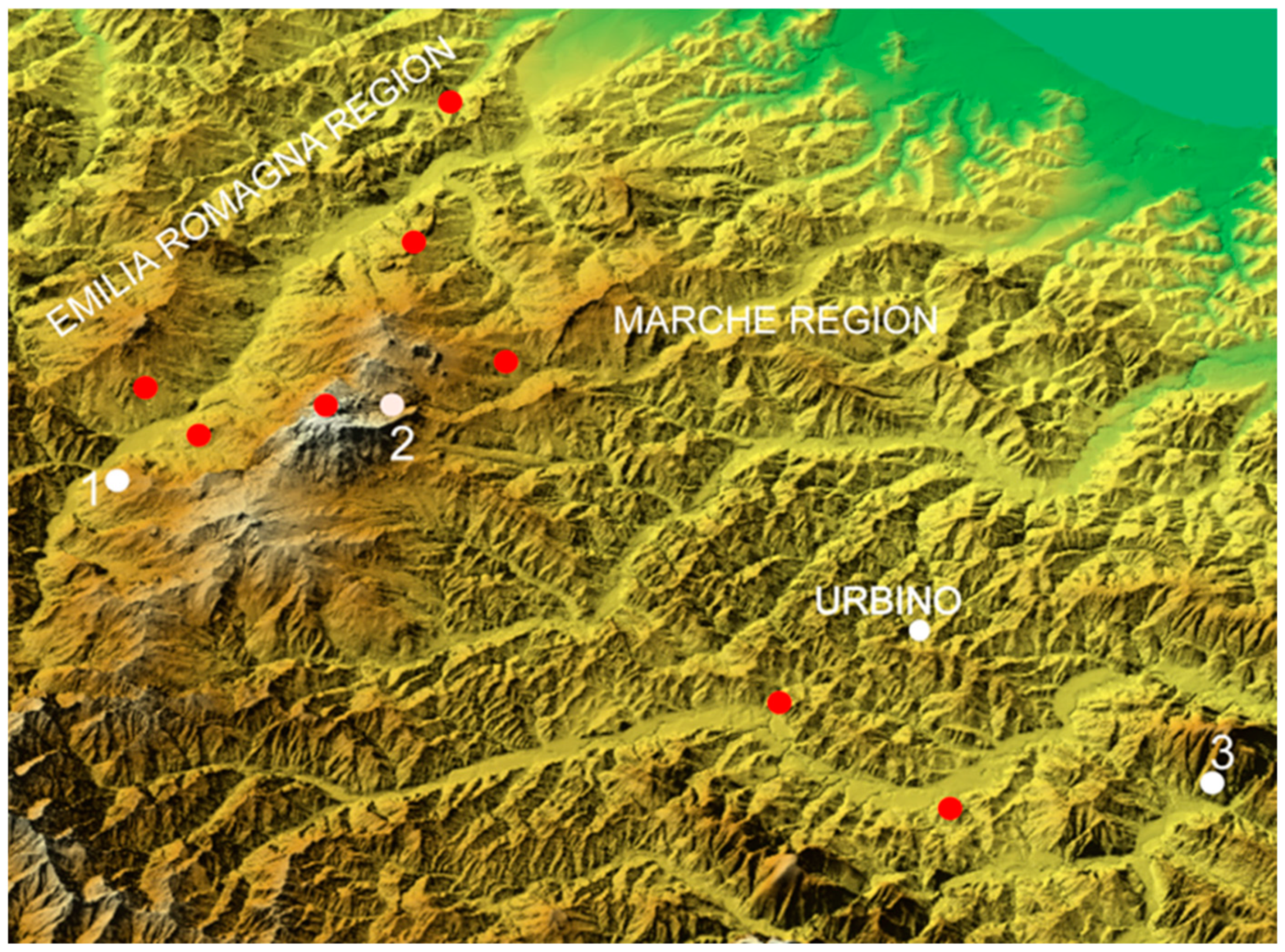
Today, in this territory, which once was the ancient dukedom of Urbino, it is possible to have an unusual experience: to enter into a work of art, becoming part of the landscapes of Piero della Francesca, which were painted in the 15th century. Seven observation points, called “Piero’s balconies”, are scattered around the countryside. Here, it is possible to admire the same scenery that inspired Piero della Francesca during the many trips he made to reach his most important patrons in the courts of Urbino and Rimini.
Unexpectedly, the ancient Duchy of Urbino area has inherited an extraordinary cultural legacy from Leonardo da Vinci, Piero della Francesca, Raphael, and others. Indeed, this research shows that many great masterpieces of the Italian Renaissance should be framed among the rolling hills near Urbino and the limestone peaks and cliffs of the Marecchia Valley.
The first project on Piero della Francesca’s paintings developed in several directions: a series of collateral initiatives accompanied the research and identification of elements of the represented landscapes. First, the project was also articulated from a tourist–cultural perspective, aiming to implement geotourist attractiveness and promote an area with great aesthetic and cultural potential but that was still little known.
The year 2008 marks a critical milestone for this research: Leonardo da Vinci’s “Gioconda” landscape was identified between the Romagna, Marche, and Tuscany regions [
62].
The research has been published in scientific journals and numerous popular publications [
20,
60,
62,
63]. Several conferences and exhibitions have also been held in Italy (Alma Mater Studiorum, University of Bologna; Faculty of Conservation of Cultural Heritage, Ravenna; Benetton Foundation, Treviso; National Academy of Sciences, Letters and Arts, Modena; Cenacle of Culture and Society, Bologna; Institut Français, Firenze; European Center for Landscape Study, Roma; MUSE Science Museum, Trento) and abroad (Amsterdam, London, Sofia, Lyon, Manama, Helsinki, Krakow, Beirut, Lisbon, Dubai).
Thus, the Montefeltro Renaissance Views (MVR) project was born, under which itineraries were designed to retrace the journeys of Piero della Francesca, Leonardo da Vinci, Raphael Sanzio, and other great Renaissance artists. Visitors are accompanied by specialized guides along the routes that connect the places visited by the illustrious figures of the past, arriving at the sites from which the backgrounds for the works of these artists were captured. The guides have geology and geomorphology expertise and focus on the pictorial works representing the place. Thanks to the support of the Marche and the Emilia-Romagna regions, the project has developed new forms of cultural approach to create a new and alternative concept of “museum” for an integrated reading of the territory. These studies on the backgrounds in Renaissance paintings, moreover, have been in parallel with a prolonged activity aimed at the enhancement of geoheritage and the development of geotourism, both in the Marche Region and in the Marecchia Valley area [
64,
65,
66,
67].
Explanatory panels were set up on the balconies to help visitors recognize the landscape details they observe in the artwork. In 2016, two balconies were also made (
Figure 4), one for the left and one for the right side of Leonardo da Vinci’s “Gioconda”, located in the territory of Pennabilli and Villagrande di Montecopiolo (RN).
Seven “balconies”, which are the observation points from which the author “captured” the landscape (
Figure 4), were made for seven paintings by Piero della Francesca.
Since 2013, guided tours and events were organized with specialized guides and professional actors who played the characters of the period, trying to involve the participants more: Piero della Francesca approaches on horseback and talks about the landscapes, his journey, and his works. Visitors can visit the balconies independently and read the explanations on the panels set up at the sites. Numerous events have been organized on Piero della Francesca’s balconies, with significant public participation and high interest from participants.
Figure 5 shows photos of the balconies already set up and pictures of some of the events.
A new international project, named RECOLOR, involving Italy and Croatia, was proposed and developed in 2021 [
68]. The project’s general goal is to enhance the tourist potential of urban and natural landscapes in these two countries, often not fully exploited or included in traditional tourist circuits. Moving from analyzing figurative artworks and promoting tourist itineraries based on them, the project is innovative in its capacity to address both natural and cultural heritage. A new methodology is adopted, including analyzing the landscape of available artistic sources (paintings, bas-reliefs, sculptures, architectural, archaeological, etc.), identifying existing art landscapes, and developing cultural itineraries through these landscapes to select and promote European art landscapes.
Walking through a natural landscape that inspired the work of art, the visitor experiences a tension between past and present, between landscape permanence and transformation; he will reconstruct (virtually or not) the work of art in search of what has been removed and preserved over the centuries. Creating entertainment experiences that appeal to art lovers and non-acculturated tourists makes these products critical in rebalancing tourist flows from nearby seaside localities to the hinterland and from the summer months to the off-season. The project idea is realized with the participation of the local stakeholders (municipalities, provinces, regions, universities, cultural institutions, public and private associations) and the local community.
4. Results
This section presents the research conducted on the backgrounds of three famous works painted by three great artists: “Nativity” by Piero della Francesca, “Madonna Litta” by Leonardo da Vinci, and “Knight’s Dream” by Raphael.
4.1. Piero Della Francesca: Nativity
The “Nativity” is a painting on panel of 124.4 × 122.6 cm, made in the early 1480s, exhibited in London at the National Gallery Museum (
Figure 6).
The Virgin is kneeling in adoration of her newborn son in front of a ramshackle shed, emphasizing Christ’s humble birth. She is accompanied by her husband, Joseph, and two shepherds. Some musician angels provide a heavenly soundtrack to the situation. In the background, on the left, a richly detailed landscape, typical of his hometown, can be discerned. Details of a town are shown on the right (
Figure 7).
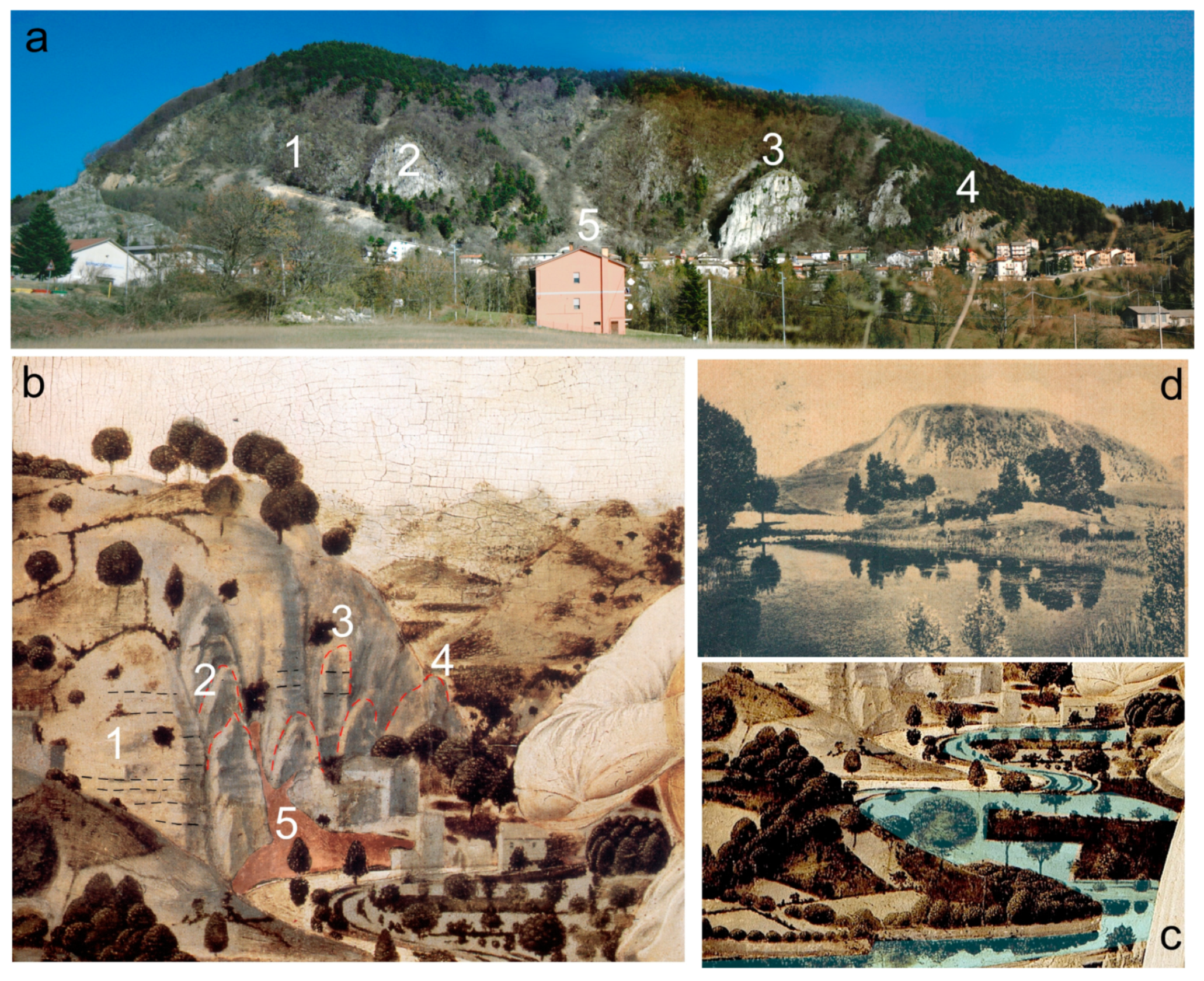
A careful analysis of the morphologies depicted in the background made it possible to identify the depicted landscape, recognized in the territory of the Duchy of Urbino, within a panoramic view from Mount Carpegna towards the Adriatic Sea (
Figure 8). Specifically, we are in the northwestern part of the province of Pesaro–Urbino, within the Conca River basin, near the southeastern watershed of the Marecchia River. The well-known geological features of Monte Montone were crucial in the recognition of this landscape.
Unfortunately, the dense vegetation that now covers the slope almost completely hides these landforms, which instead appear more evident in the painting.
A layer of debris consisting of both fragments and large rock masses is visible at the foot of Mount Montone, which is the result of the slow degradation and breaking up of the rocky slope above. There are also many surface landslides where large rocky boulders have broken away, accentuating undulations and limestone brought down by the landslides (
Figure 9a,b). A stream flowing into a lake basin, located on the slopes of Mount Montone, represents an important landscape detail, clearly visible in the painting (
Figure 9c). The existence of a lake in Montecopiolo, no longer present in the current landscape, is testified to in rich detail, in several historical documents and recent archaeological research [
69,
70,
71,
72]. Some old photos also bear witness to the presence of a marshy area near Mount Montone (
Figure 9d).
The painting shows a small church just below the limestone crag. The church of St. Michael the Archangel stands here today, but it was built later, and its location differs from what the painting shows. Continuous landslides and falling debris at the base of the crag may have convinced the local community to move both the church and the houses further down the valley, as described by Luigi Dominici [
69].
Figure 10 compares some details of today’s landscape and the painting. Mount San Paolo, Mount della Valle, Gemmano, Montefiore Conca, Mount Montone, and Montecopiolo are easily identified in the painting. It is worth dwelling on the depiction in the painting of Montecopiolo Castle, which is the place of origin of the Montefeltro family [
71]. The high ground of Montecopiolo was already inhabited in prehistory and Roman times and was fortified in the 10th century. According to the castle’s traditions, the dukes of Urbino, the Montefeltro, originated there. In 1140, the castrum montis cupioli was, in fact, assigned to Antonio da Carpegna, who was considered the founder of the Montefeltro family. In 1448, the castle resisted the assaults of Sigismondo Malatesta and, in 1502, was used by Duke Guidobaldo as a refuge during the occupation of the duchy by Valentino (Cesare Borgia). In 1552, it was put under siege by the troops of Giovanni de’ Medici: the castle suffered some damage but was not destroyed. It was then gradually abandoned during the 18th century [
73].
Piero della Francesca never painted anything by chance; he did not fantasize or invent. Each element of his paintings, whether figures, mountains, fields, or turf, was real and functional for a specific purpose. Like all his artworks, this painting provides much information about his working method and patron. Two different landscapes are painted behind the figures in the foreground. The first on the left depicts a rural Montefeltro landscape on the slopes of Mount Carpegna: Mount Montone and Montecopiolo. Montecopiolo is known as the birthplace of the Montefeltro family between the 11th and 13th centuries. The second landscape, on the right, depicts an urban landscape in which the city of Gubbio, a place of residence of the Montefeltro family, was identified. Thanks to the recognition of the landscape, it was possible to reinterpret the entire painting, including the figures in the foreground.
Four nativities emerge from analysis of the painting: the birth of the Montefeltro lineage, the birth of Federico da Montefeltro, his son Guidobaldo, and, of course, the birth of Jesus. On the slopes of Mount Carpegna, on a flowery lawn, Piero sets his nativity among the sounds and sweet harmonies of young musicians and singers. In front of the “stable”, the first figure is the mother of Christ with exquisite clothes, hair, red lips, pearls, a jewel at her throat and in her hair. The Virgin Mary is not usually so adorned. Did Piero want her to be identified with a real character? The blue cloak, which should cover and warm the Child, is placed beneath his body and is part of the Virgin’s dress, giving a sense of ownership. The woman has a light complexion, a high, bare forehead, ethereal, imperceptible eyebrows, and rich reddish hair, closely resembling Battista Sforza, Federico da Montefeltro’s second wife and recently the mother of Guidobaldo (
Figure 11a). The town of Gubbio, on the right, is located not far from Urbino and, at the time, was part of the same duchy (
Figure 11b). Not coincidentally, Federico was born in Gubbio in 1422, and his son Guidobaldo in 1472.
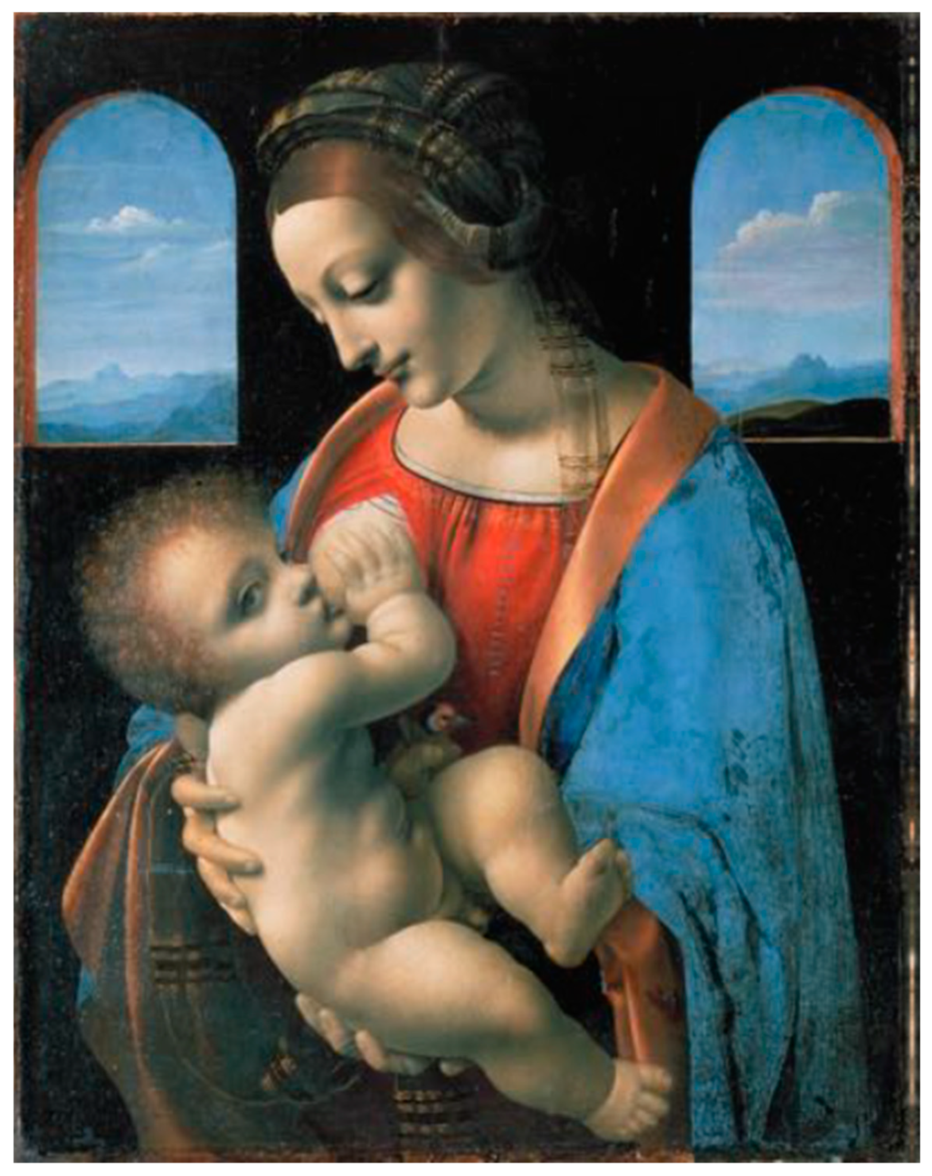
4.2. Leonardo da Vinci: Madonna Litta
When Leonardo da Vinci came to the Montefeltro in 1502 following the Borgia army, his job of supervising the fortifications and military structures of the territory took him to all corners of the dukedom, from the highest peaks of the Apennines to the many hills around Urbino, from crags to valleys to rivers with their many bridges and towers. In Urbino, in fact, he was employed by Cesare Borgia, il Valentino, as superintendent of military works and structures between the Romagna and Marche regions. During his visit of nearly 40 days, he stayed just outside the town walls, in a house with a tower run by Franciscan monks who, before he left, probably asked him to design a dovecote addition to their tower. There are dovecote studies made by Leonardo that explain how to construct a large compartment made up of little cells for nest building.
We are proud and confident that this area delighted him. This unspoiled corner of the world is the same masterpiece as 500 years ago.
On the other hand, we have studies that prove that in the northern part of the ancient Duchy of Urbino, on the border with Tuscany, among the beautiful limestone peaks and crags of the Marecchia Valley, Leonardo immortalized the background of the Gioconda [
60,
62].
Some new landscapes in Leonardo’s paintings have recently been identified in this area by our working group and are being analyzed. This section considers the landscape that Leonardo da Vinci placed in the background of the “Madonna Litta”, a tempera painting on panel, 42 × 33 cm, exhibited at the Hermitage Museum in St. Petersburg (
Figure 12).
The landscapes visible through the two windows behind the Virgin Mary (
Figure 13a) were recognized as the three crags of Maiolo (on the left) and Penna and Billi (on the right;
Figure 13b). A detailed and careful geomorphological survey of the area established that the background is taken from the same landscape but painted from two different viewpoints.
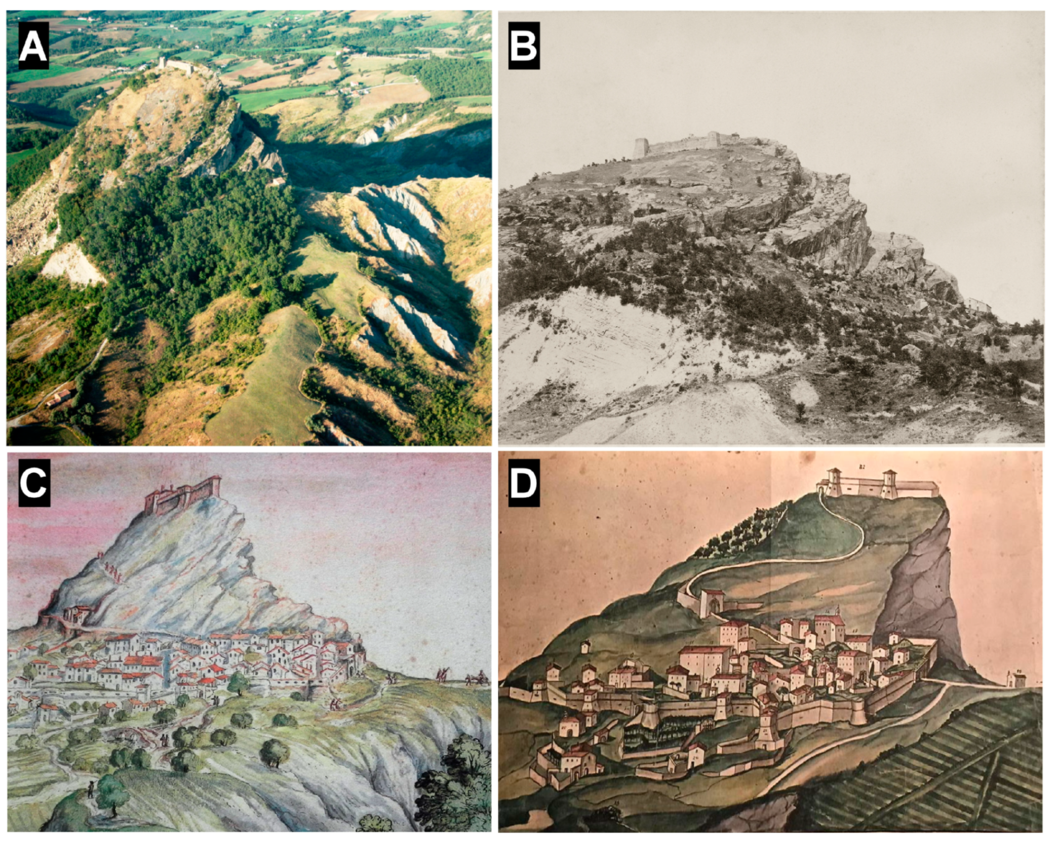
Dominici (1931) provides a fascinating description of the Maiolo cliff and of a landslide event that changed its shape:
Maiolo is a steep crag that rises on the right bank of the river, not far from San Leo. On its summit still stand the ruins of a castle and the debris from walls and towers that bear witness to a glorious and almost legendary past. The first historical documents date back to the 8th century, but its origins are more ancient, and control over it has been contested by many lords. However, in 1700, the community of Maiolo suffered a catastrophe in the form of a landslide. On the night of 29 May, due to the erosion of underground water, the rock and village which lay at its feet were swept away along with most of the houses and inhabitants, leaving treacherous cliffs [
69].
Figure 14A shows a recent image of Maiolo, and
Figure 14B shows a picture of Maiolo dating back to 1937. Some important works of art bear witness to the crag and the village before the great landslide: i: a drawing by Francesco Mingucci (
Figure 14C), an Italian painter and cartographer born in Pesaro between 1570 and 1590; ii: a glorious anonymous work dated between the second half of the 18th century and the beginning of the 19th (
Figure 14D) [
74]; iii: the background of the famous Battista Sforza painted by Piero della Francesca [
60].
4.3. Raphael Sanzio: Knight’s Dream
The “Knight’s Dream” is an oil on panel of 17 × 17 cm (
Figure 15), made in 1504 and exhibited in London at the National Gallery Museum.
The earliest records of the work come from the Borghese collection in Rome, which was inventoried with its pendant, “The Three Graces”, now exhibited at the Condé Museum in Chantilly (France). In the late 1700s, it was purchased and transferred to England. Later, the work belonged to an English nobleman and was resold in London. After other purchases and passages in various art collections, it was given to the National Gallery in 1847. The diptych was probably commissioned by the mother of Francesco Maria della Rovere, the new successor to the Duchy of Urbino [
75].
After the Furlo Gorge, traveling southwest along the Candigliano Valley, following the Flaminia consular road that cuts through the Piana dei Conti in the direction of Acqualagna, a narrower section is reached because of the surrounding relief. Those who traveled the consular road were constantly controlled from above: small fortifications, simple towers, or more articulated defensive structures had, in fact, sprung up on the surrounding heights, guarding the section of the Flaminia between the Furlo Gorge and that of the Burano River. The purpose was to prevent enemies’ passage and defend the crops of the valley floor. Significant evidence of some of these fortifications still remains; after the Furlo and after the Abbey of San Vincenzo, controlling this passage, stood the first important defensive fortification, Drogo Castle.
Figure 16 compares the Candigliano Valley, located in the ancient duchy of Urbino, and Raphael’s painting. The background of the Knight’s Dream has been recognized as the broad valley of the Candigliano River between the Furlo Gorge and the Catria-Nerone ridge. The geological and geomorphological features identified in Raphael’s little masterpiece, in fact, show obvious similarities in this landscape. In the distance, the Apennine range, culminating in the peaks of Mount Catria, Mount Acuto, and Mount Petrano, shows the same structural features as the relief painted by Raphael. In particular, the unmistakable profile of Mount Petrano has been accurately reproduced in the background with the typical flatiron reliefs in the foreground. At the confluence of the Bosso and Burano streams, where the town of Cagli rises, the alluvial plain unfolds to its full extent.
Figure 17a shows an ancient map of the Duchy of Urbino, with evidence of numerous small fortifications in the hills, including Drogo Castle. The rocky mass on which Drogo Castle stands corresponds to the marly limestones of the Bisciaro Formation, while at the base of the cliff emerges the more marly Scaglia Cinerea Formation and, near the river, the Scaglia Variegata Formation (
Figure 17b).
Figure 18a shows the background landscape in its different depth planes. A detail of a preparatory drawing also provides essential insights (
Figure 18b).
The scene occurs on an elevated site (1), characterized by compact grayish rocks; rare and scattered sharp-edged pebbles derived from the substrate rocks are observed. In the second plane (2), a series of hills set in a softer lithology are visible, producing a gentle morphology. In the third plane (3), a change in color and compactness of the rocks is evident (the hill is morphologically higher and, therefore, more resistant to erosion), indicating a change to a different lithology. Selective erosion processes bring out the large rock on which the castle rests. The last background (4), marked by a uniform bluish color on the horizon, highlights a ridge of lithified rocks characterized by morphostructures typical of anticlinal reliefs. A large valley crosses the ridge in a transverse direction, but the arm of the Muse on the right prevents us from observing in which direction the river flows. However, Raphael provides a further important indication in the preparatory drawing: a small bridge could likely be set across the main river in the white frame. This indication could support the hypothesis that the river, with a wide bend, deviates to the left, passing below the arm of the Muse placed on the left. It is unknown why this morphological detail was not reproduced in the painting, where, on the contrary, a road with three horsemen riding along it is visible.
The long bridge over the plain (number 5 in
Figure 16), now called Piana dei Conti, probably allowed the crossing of the Candigliano River and the plain, periodically flooded by the river’s waters. Today, that place is called the Iron Bridge.
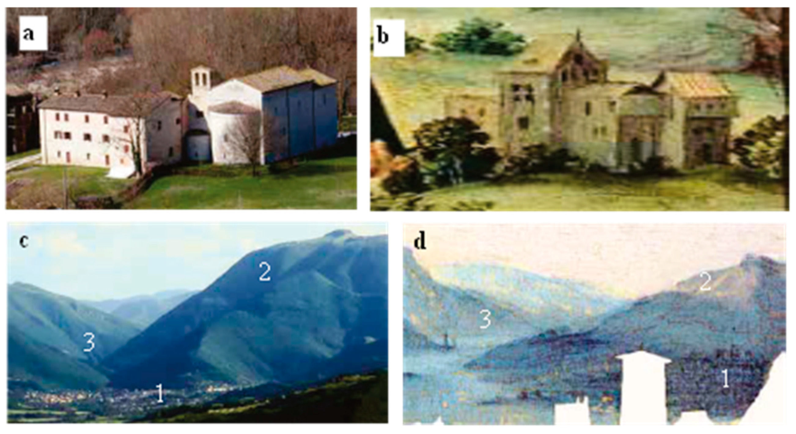
The Abbey of St. Vincent stands near the Furlo Gorge. Its first record is found in a document from 970, although the construction appears much older. St. Romuald (1011) stayed in this important complex, one of the great reformers of monasticism, and St. Pier Damiani (1042), a well-known Italian theologian, bishop, and cardinal. In the 13th century, the Abbey went through strong struggles with the nearby town of Cagli to control some castles, including that of Drogo. In 1246, it was damaged by fire and was rebuilt in 1271. Today, the restored church (
Figure 19a), thanks in part to its location along Flaminia Road, is visited by many tourists every year.
Figure 19c,d compare the current landscape with the city of Cagli (1), Mount Petrano (2), and the Burano Gorge and the painting.
Although the Knight’s Dream is a tiny painting, it is rich in detail; it is a true miniature, executed by Raphael in his youth.
5. Discussion and Conclusions
The results achieved in these years of research and projects, in terms of tourist participation and acclaim, have been exciting. The excursions, involving purely sporting (walking), naturalistic, scientific (about the genesis and evolution of the landscape), artistic, educational, and performance (the events include the presence of actors) aspects, have proven to be very effective and capable of engaging a broad and heterogeneous public.
Numerous other paintings by Leonardo da Vinci and Raphael Sanzio have been recently investigated, some of which have been identified and located in this area. New balconies will be set up in the coming years, creating a proposal for cultural itineraries that are increasingly rich and stimulating.
We believe that these studies can represent great potential for the enhancement of this territory. The interdisciplinary nature of the research, in fact, has the ability to attract the attention of a wide and varied audience, making it easy and pleasant for the fundamental process of dissemination of an asset of inestimable value: the landscape.
There is a considerable variety of landscapes representative of the different regions of the Earth. Landscapes are works produced by the combination of nature and man, expressing a long and intimate relationship between peoples and their natural environment [
76]. To represent and sustain the great diversity of interactions between human beings and the natural environment, to protect living cultures, and to preserve traces of those that have disappeared, some of these places, called cultural landscapes, have been inscribed on the World Heritage List.
In 1992, the World Heritage Convention became the first international legal instrument to recognize and protect cultural landscapes [
77]. The Committee acknowledged that cultural landscapes represent the “combined works of nature and man” and adopted guidelines concerning their inclusion in the World Heritage List.
The term “cultural landscape” embraces a diversity of manifestations of the interaction between humankind and its natural environment. Protection of cultural landscapes can contribute to sustainable land use and maintain or enhance natural and cultural values [
78,
79,
80,
81].
Cultural landscapes fall into three main categories (Operational Guidelines 2008, Annex3; [
82]): 1—the well-defined landscape intentionally designed and created by man; 2—the organically evolved landscape; 3—the associative cultural landscapes. The inclusion of the latter in the World Heritage List is justified by the powerful religious, artistic, or cultural value of the natural element; thus, here are the landscapes depicted in works of art.
The landscapes in the background of Renaissance paintings are real places, although sometimes modified by geomorphological processes, probably resulting from climate change or direct or indirect human action. These landscapes are often identified with the characters portrayed in the foreground. It is well known that artists could not always express their creativity, especially in portraiture, where they were subject to the will of patrons, who often decided what to include in a painting to immortalize their dominance and good governance [
83].
It is intriguing that the historical memory of our land can be better understood through a new approach to the most famous Renaissance works of art. The Duchy of Urbino area, world famous for its natural landscapes of undoubted aesthetic appeal and its unique geological evolution, has become not only a new horizon of knowledge as “landscape art” but also an unexpected cultural resource to share, transmit, and promote.
In conclusion, the projects developed over the past 15 years have brought to light a great resource in the landscapes of this area, which deserves to be enhanced, popularized, and protected. For this reason, we wish to report them to the international scientific community so that they can be considered part of the UNESCO cultural landscapes identified in Italy and propose their inclusion in the UNESCO World Heritage List [
84].
The greatest result of this prolonged multidisciplinary research is to have created an extensive outdoor museum with observation points that lead visitors through the extraordinary experience of being part of amazing works of art.


