Article

Slope Stability Assessment Using Trigger Parameters and SINMAP Methods on Tamblingan-Buyan Ancient Mountain Area in Buleleng Regency, Bali

1
Department of Civil and Environmental Engineering, Faculty of Engineering, Universitas Gadjah Mada, Yogyakarta 55281, Indonesia
2
Center for Disaster Mitigation and Technological Innovation (GAMA-InaTEK),Universitas Gadjah Mada, Yogyakarta 55281, Indonesia
3
Department of Geological Engineering, Faculty of Engineering, Universitas Gadjah Mada, Yogyakarta 55281, Indonesia
*
Authors to whom correspondence should be addressed.
Geosciences 2017, 7(4), 110; https://doi.org/10.3390/geosciences7040110
Submission received: 7 August 2017 / Revised: 24 October 2017 / Accepted: 25 October 2017 / Published: 28 October 2017
(This article belongs to the Special Issue Natural Hazards and Risks Assessment)

Abstract

:
The mapping of soil movement was examined by comparing an extension of the deterministic Soil Stability Index Mapping (SINMAP) method, and an overlay method with trigger parameters of soil movement. The SINMAP model used soil parameters in the form of the cohesion value (c), internal friction angle (φ), and hydraulic conductivity (ks) for the prediction of soil movement based on the factor of safety (FS), while the indirect method used a literature review and field observations. The weightings of soil movement trigger parameters in assessments were based on natural physical aspects: (1) slope inclination = 30%; (2) rock weathering = 15%; (3) geological structure = 20%; (4) rainfall = 15%; (5) groundwater potential = 7%; (6) seismicity = 3%; and (7) vegetation = 10%. The research area was located in the Buleleng district, in particular in the ancient mountain area of Buyan-Tamblingan, in the Sukasada sub-district. The hazard mapping gave a high and very high hazard scale. The SINMAP model gave a validation accuracy of 14.29%, while the overlay method with seven trigger parameters produced an accuracy of 71.43%. Based on the analysis of the very high and high hazard class and the validation of the landslide occurrence points, the deterministic method using soil parameters and water absorption gave a much lower accuracy than the overlay method with a study of soil motion trigger parameters.

1. Introduction

There is a high demand for public information related to spatial planning and environmental protection against landslide hazards, and as such landslide-related hazard assessment has become the main tool in risk management and an integral part of land-use planning in disaster-prone areas [1,2]. Zoning of landslide hazards is associated with the environmental conditions involved in homogeneous land sharing. Determination of the level of threat is based on the classes specified by the researchers themselves and their objectives and experiences. Hazard assessments are usually indicated on a map which displays spatial distributions or hazard class zones [3,4]. However, the probability of landslide events is still difficult to clarify in most of the hazard maps due to different environmental conditions and the scarcity of previous landslide events or historical events [4,5]. As a result, most of the published hazard maps present only spatial information of landslide hazards and do not provide an estimate of when a landslide may occur.
Various methods have been developed and applied to landslide hazard assessments in recent years, ranging from simple to very sophisticated methods, using a large number of landslide parameters [6]. Hazard assessment can be classified into two approaches, namely, qualitative and quantitative methods. The choice of this method relies heavily on the accuracy of the results and the nature of the problem and must be made depending on the quality and quantity of the data available. Generally, for large areas where the quality and amount of available data is too limited for quantitative analysis, threat assessment with qualitative methods is more appropriate. In contrast, for slopes in close locations an equilibrium boundary strength analysis is performed, which requires a detailed quantitative assessment of hazards.
Assessment and weighting have been performed by Indonesian scientists using semi-quantitative methods or heuristic methods for a depiction of risk maps. This involved overlapping using geographic information (GIS) to create landslide threat maps, and assessment and weighting applied to several parameters based on their relative contribution to landslide hazards. Other studies that have been conducted include comparisons of Soil Stability Index Mapping (SINMAP), and Shallow Slope Stability (SHALSTAB) modeling approaches for slope stability analysis at shallow landslide sites, showing the practical advantages and limitations of the two models with respect to the highly dependent characteristics of local geological conditions [7].
Bali island is characterized by generally steep rolling hills in the northern part and steep plane morphology in the southern part [8]. The geological structure of most areas of Bali island is composed of clastic volcanic rocks from the Quaternary age. Rocks in the northern part of Bali island have been strongly deformed, marked by the many geological structures including both faults and folds. The Flores Thrust stretches from the north to the south of Bali Island, while the eastern part consists of the tuffs and volcanic breccias which were formed in the Pleistocene age (dating back from 2.33 ± 0.12 million years to 0.77 ± 0.06 million years ago), and are very easily eroded by rain [9]. There are various geological conditions and geological structures in each region, which are the dominant controlling factors in the evolution of landforms and geological structures, and these dynamics are reflected by landforms [10,11]. In addition, a landslide with a gentler slope occurs with a lower dynamic coefficient of friction values, and in the case of the debris flow, there tends to be an even lower dynamic friction as compared to the case of landslides high slope declination [12]. The Buyan-Beratan Purba volcanic rock group (Qpbb), consists of tuffs and volcanic lava sediment from Buyan-Beratan and Batur, which are from the upper Quaternary age. The appearance of landscapes and geological conditions is based on the geological map of Bali sheet [13].
This study, conducted in the Buleleng district, covers an area of 1365.88 km2 or 24.23% of the Bali province area, with the Sukasada sub-district being the main observation location because this area often experiences landslides. Administratively, the area of the Sukasada sub-district, which measures 366.92 km2, comprises about 70.45% of the Buleleng district area. This study was conducted in the Buleleng district, which is a district formed in the overflow of the Buyan-Beratan ancient mountainous areas and has a high occurrence of landslides (36.5%) [14].
The primary purpose of this paper is to present a landslide hazard assessment by comparing the deterministic and semi-quantitative methods around the ancient mountainous area of Tamblingan-Buyan in Buleleng, so that the most relevant methods in the area can be identified and applied under the same location conditions. The semi-quantitative method with overlay operation in GIS is used to analyze the following physical aspects of nature: (1) slope inclination; (2) weathering rocks; (3) geological structure; (4) rainfall; (5) groundwater potential; (6) seismicity; and (7) vegetation. The deterministic method with SINMAP extension analyzes the landslide potential area using soil parameters. In this type of modeling, the area is divided into six classes, whereby each region has a stability index value to determine whether it is in an area with landslide potential or not.

2. Methods and Theoretical Framework

2.1. Analysis Method

The deterministic method was based on the analysis of slope stability by considering the safety factor of the slope. Deterministic methods were used for mapping on a large scale in not-so-wide areas, so the deterministic method required detailed physical and geotechnical data.
The indirect method calculated the density of soil or rock mass movement and the weight value of each unit/class/type for each soil or rock mass movement control parameter. The density calculation was conducted by considering the soil or rock mass movement range in an area. Each unit/class/type of parameter map, overlaid with a soil or rock movement distribution map, will result in the density of soil or rock movement in each unit/class/type [15,16].
Advanced Spaceborne Thermal Emission and Reflection Radiometer Digital Elevation Model (ASTER-DEM) 2 data was used in this study, with a pixel accuracy of 30 m × 30 m. The daily rainfall data for the period from 1994 to 2016 was taken from five rainfall recording stations and the landslide point data was the primary type of data used as the control point. Data on soil properties including soil depth (h), cohesion (c), and internal friction angle (φ) was based on the results of laboratory tests and other laboratory data. The hydraulic conductivity values were obtained from the soil physical properties table [13].
The data of landslide occurrence points as shown in Figure 1 served as a comparison of whether the resulting map matched the reality in the field or not. The location of control points taken for the study was divided into two parts, namely, the locations which were considered stable, and the locations which were considered less stable. Stable locations were taken at several points in urban areas and the less stable areas were taken at some points in the Sukasada sub-district area, an ancient mountainous area of the Beratan-Tamblingan-Buyan region prone to landslides, based on the information on landslide disasters and the information from the Buleleng district community.

2.2. Methodologies

2.2.1. SINMAP Analysis

SINMAP was used at regional scale level or a broader in accordance with the research thesis conducted by Prabin Kayastha, entitled “Slope stability analysis using GIS on a regional scale” [17], which covered a study area of 347 km2, and Govind Acharya’s study entitled “GIS Approach for Slope Stability Risk Analysis: A Case Study from Nepal” (2003), which covered a research area of 885 km2. From these two studies, the application of the SINMAP model from a macro to micro scale was able to be performed by changing the parameters of soil mechanical properties, such as the cohesion value, internal friction angle, and transmittance (T/R) value of each different type of soil in the research area.
The stability index is intended to classify the hazard level of soil movement. In SINMAP, the stability index is divided into six classes (Table 1). The classes show the conditions of the area based on the stability index value or the stability index (SI).
The soil stability analysis in SINMAP, which is based on infinite slope analysis (Figure 2), is a model used to determine the factor of safety (FS) of the differences in collapse buffer force and collapse cause force [18,19]. The equations of the model are written as follows in the SINMAP manual [18]:
F S = 1 X ( A + B + C )
X = D ρ s g sin θ cos θ A = C r ;    B = C s C = cos 2 [ ρ s g ( D D w ) + ( ρ s g ρ w g ) D w ] tan φ
where Cr = root cohesion (N/m2), Cs = soil cohesion (N/m2), θ = slope inclination, ρs = wet soil density (kg/m3), ρw = water density (kg/m3), D = soil depth (m), Dw = vertical height of water surface in the soil layer (m), g = gravity force (9.81 m/s2), and φ = internal friction angle. The value of θ can be calculated using the arc tangent formula S. S is the perpendicular distance per unit of horizontal distance, as shown in Figure 2.
In this case, the hydrological model was used to explain the concept of slope stability. The relationship between the soil thickness h (m) and the soil depth D (m) is as follows:
h = D cos θ
Furthermore, the factor of security (FS) changes to:
F S = C + cos θ [ 1 w r ] tan φ sin θ
Note that:
w = D w D = h w h
is the relative wetness index
C = ( C r + C s ) h ρ s g
r = ρ w ρ s
where r = water ratio to soil density.
The combination of cohesion (Equation (5)) creates a relatively perpendicular dimensionless quantity between the soil thickness line and the water density ratio to the soil density. Equation (3) reflects a dimensionless quantity derived from infinite-slope modeling. The equation is considered appropriate by the experts because it involves the combination of the amount of cohesion (soil and roots) and soil density into the cohesion factor (c) (Equation (5)).
The model works against the slope and wetness of each grid (DEM pixel), assuming that other parameters are constant or have a constant distribution probability over a large area. Furthermore, the soil stability index is modeled by using Equation (7), which is a combination of wetness Equations (8) and (3)
F S = C + cos θ [ 1 min ( R T a sin θ , 1 ) r ] tan φ sin θ
w = M i n ( R . a T sin θ , 1 )
where w = wetness index, R = rainfall (mm/day), and a = the specific capture area (m2/m) defined as the increment of the area slope per unit of contour length, calculated by the equation a = A/b where A is the area contribution (m2), and b is the contour length unit (m). T = soil transmissivity (m2/h), calculated by the equation T = ks × h, where ks is the hydraulic conductivity (m/h) and h is the soil thickness (m); and θ = slope inclination (°).

2.2.2. Weighted Analysis

The weighting method was based on the Guidance of Spatial Planning of Disaster-Prone Areas, Decree of Minister of Public Works No. 22/PRT/M/2007 [15]. The study literature and field data were processed and arranged in the form of thematic maps, geology, a rock weathering map, a slope inclination map, a vegetation map, an earthquake map, and a hydrogeology map, with an estimate of the typology of landslide-prone areas.
The regional typology aims at analysis using the ArcGIS 10.3 Program in a depiction of a landslide hazards map, which will produce potential landslide maps covering the five very high, high, medium, low and very low hazard zone levels.
Digitalization of the typology of landslide disaster areas for assessment of parameters and depiction of hazard maps was performed by digitization of the typology of the region, based on hydro-geomorphology which was divided into three types of zones, namely:
The Type A Zone: Potential landslide zones found on mountain slopes, mountainous area slopes, hillsides, hill slopes, and river cliffs, involving a slope of >40% with altitudes >2000 m.swl (mean sea water level).
Type B Zone: Potential landslide zones at the foot of mountains, the foot of mountainous areas, foothills, and river cliffs, with the tilt of the slope ranging between 21% and 40% and a height of 500–2000 m.swl.
Type C Zone: Potential landslide zones in plateaus, lowlands, river cliffs, or river valleys, with slope ranging from 0 to 20% at a height of 0–500 m.swl.
The weighting of trigger parameters in the vulnerability level is scored as follows: (1) slope inclination = 30%; (2) rock weathering = 15%; (3) geological structure = 20%; (4) rainfall = 15%; (5) groundwater potential = 7%; (6) seismicity = 3%; and (7) vegetation = 10%.

3. Results and Discussion

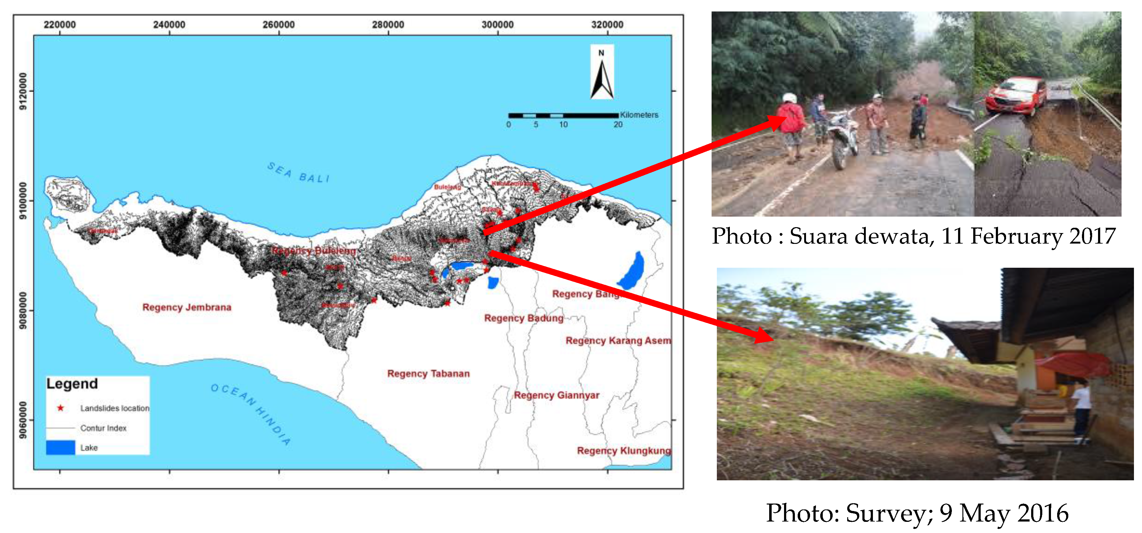
The main reason for landslides is imprudent land use. The impairments draw attention to those conditions which must be considered in the case of previously unbuilt ground [20]. The control points were in the form of points where landslides had been recorded. Based on these points, predicted landslide points were generated according to the circumstances in the field where landslides had occurred previously. The conditions of the points predicted to have low soil stability can be seen in Figure 3 and we can see that the resulting stability index map corresponds to the conditions in the field, namely, that landslides had occurred in the area where it was indicated that they would occur. The conditions of the points which were predicted to have low soil stability can be seen in Figure 4.
Soil sampling for SINMAP analysis was taken from points in 10 villages. Nine points in the villages were established with the purpose of the control of the land properties of the study area. One village (Pancasari village, with three boreholes) is the main point located in the research location. Soil property testing at 10 sampling points in the Buleleng district can be seen in Table 2.

3.1. SINMAP Method

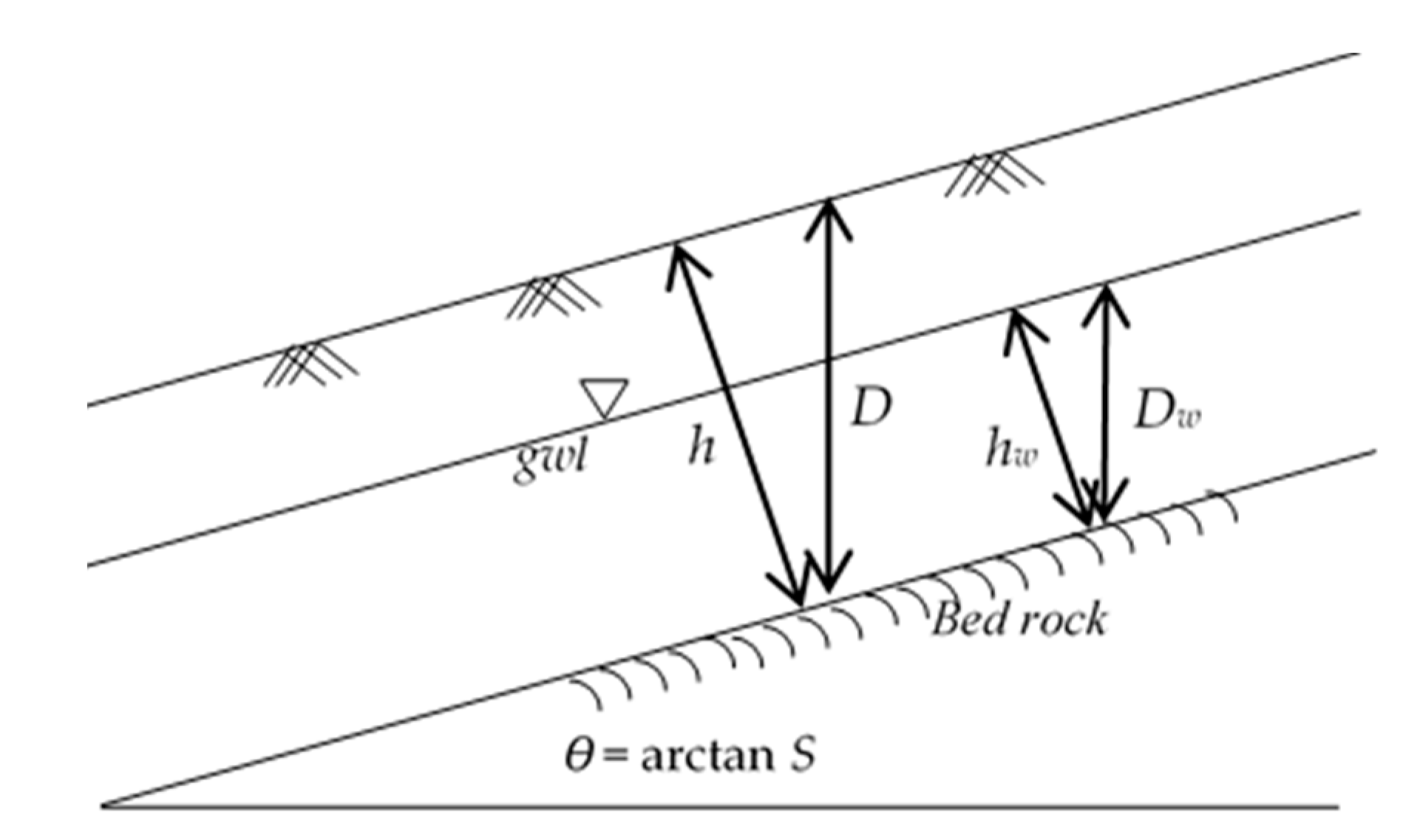
The SINMAP method, which is an additional extension of ArcGIS, is used to analyze the assessment of the hazard level for landslides. The study is only carried out in a narrower area, the Buleleng regency, in particular in the Sukasada sub-district, which is an ancient mountainous area. The sampling of soil in the research area used in SINMAP was performed using the cohesion value and the internal friction angle, which determined the range between the lower limit and upper limit, depending on the dominant soil type in the research area. Boreholes for sample controls were also used in other regions around the study area.
The research area in Buleleng District, as seen in Table 1, had a cohesion value (c) with the lowest lower threshold of 0.427 kPa and the highest upper threshold of 0.919 kPa. The friction angle value in soil (φ) with the upper threshold was 42.88°, and the lower threshold was 18.99°. Referring to the soil hydrology classification table based on the soil texture [3,21], the hydraulic conductivity value for the sandy clay loam soil type was 0.43 cm/h, and for silty clay it was 0.09 m/h. The transmissivity value obtained for the upper threshold was 0.0215 m2/h and for the lower threshold it was 0.0027 m2/h with a soil thickness of 4–5 m.
The parameter values R (for upper threshold R and lower threshold R), were found using the wettest monthly rainfall in each year per rain station, after the wettest month in each year had been determined. Next, the wettest week averages of each year were determined so that the rain data was obtained for the maximum seven-day rainfall. As per the rainfall station in Sawan village, the wettest month was in November 2005, with maximum rainfall (Rmax) of 125 mm and minimum rainfall (Rmin) of 65 mm. Based on the above data and analysis, the soil moisture index (T/R) was obtained using a lower threshold of 0.5184 m and an upper threshold of 23.88 m.
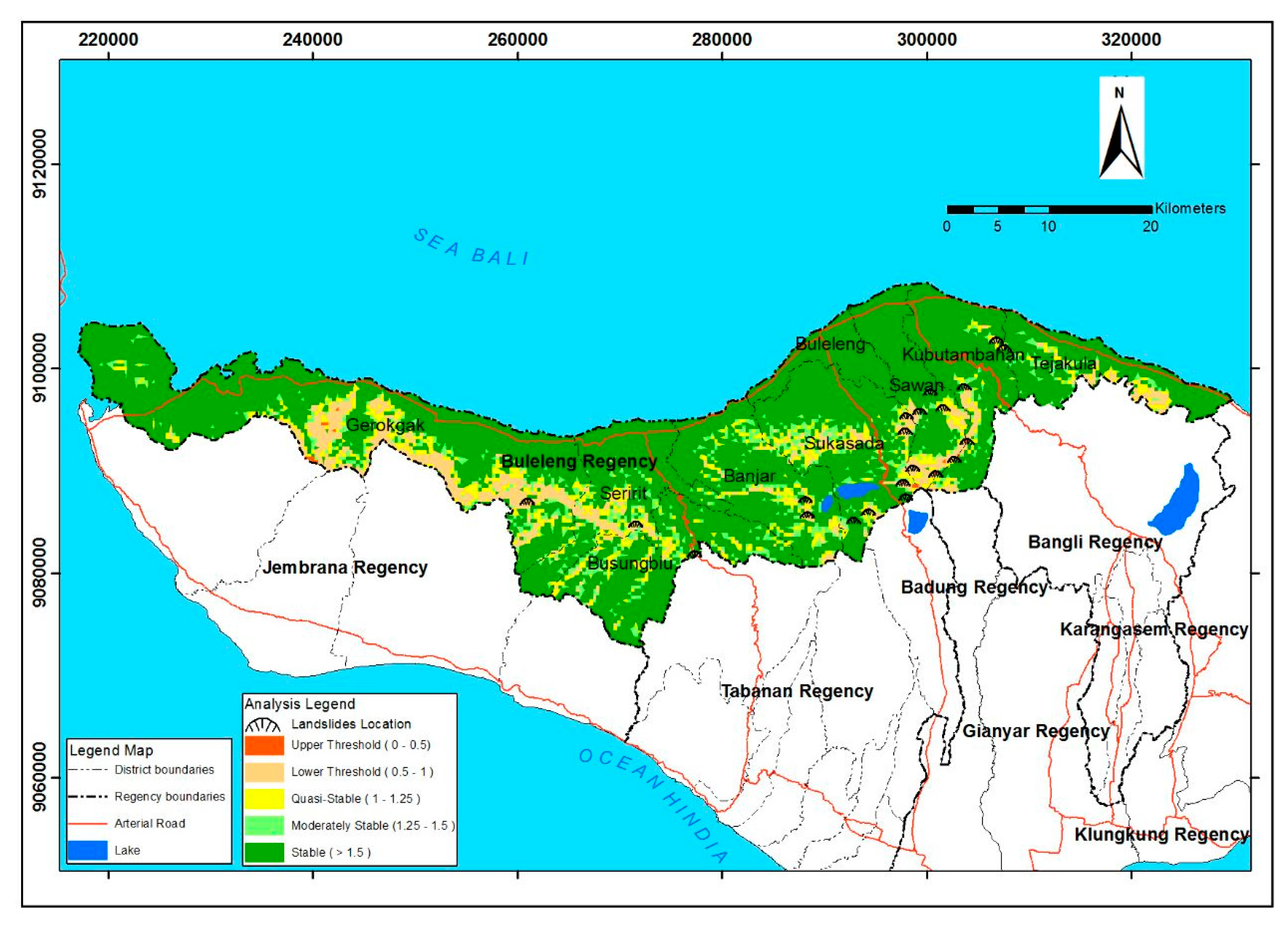
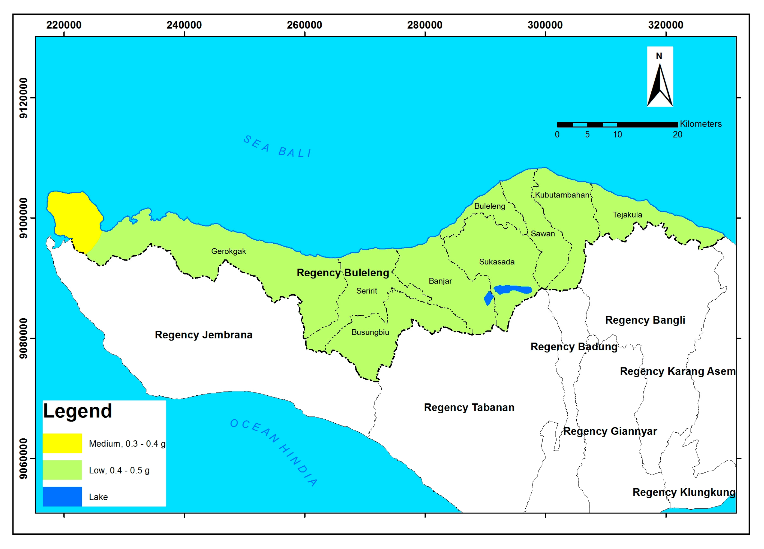
Table 3 and Figure 4 show a map of the soil movement hazard based on SINMAP modeling. The soil movement hazard level in the Buleleng district was rated at a moderate to high level. The medium hazard level was 9.39%; in an area of 12,831 ha, including total landslide events, there were as many as 13 landslide points with a landslide density of 0.0001 landslide per ha. The high hazard level was 0.19% or 253 ha with landslide events, with as many as five landslide points and a landslide density of 0.0004 landslide per ha.
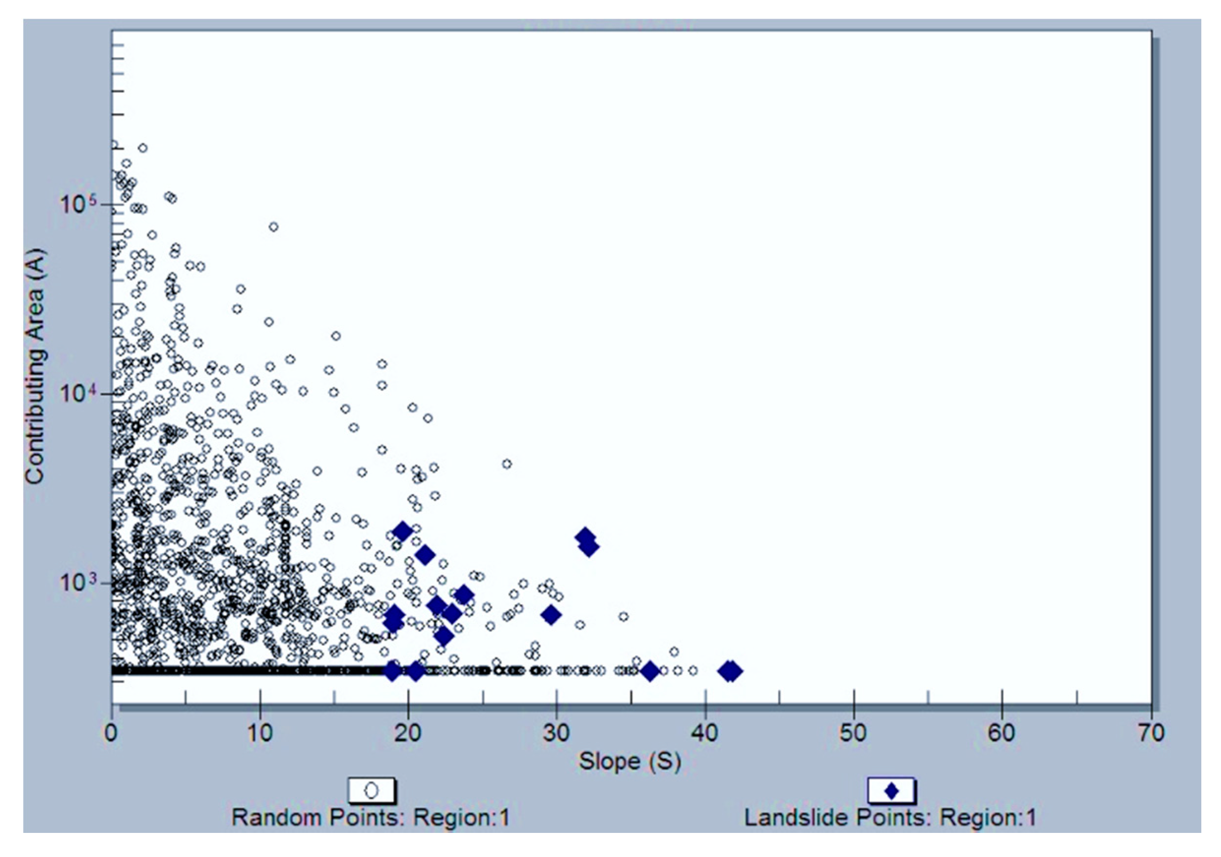
SINMAP modeling showed the spread of landslide points based on the slope and area (S-A plot) as shown in Figure 3. The unstable slope stability level generally started to occur on the slope inclination between 20° and 40°, with the area covering almost 1000 m2. Based on the density of plot points through which we could also find the distribution points of landslide spots; the spread of most landslide points was on a slope inclination between 20° and 25°.

3.2. Assessment Parameters

According to the Regulation of Minister of Public Works Decree No. 22/PRT/M/2007 the weighting of each parameter was recommended in the regulations as follows: 30% slope inclination; 15% rock weathering; 20% geological structure; 15% rainfall; 7% groundwater potential; 3% seismicity, and; 10% vegetation. Based on the literature study, all the assessment components are relevant to the environmental conditions in Indonesia as a tropical country. The use of these seven parameters is very appropriate in this study. Assessment of the weight of landslide threat on each indicator is done through multiplication of the index weight by scoring weight. There were five scoring levels for hazards: (1) very low; (2) low; (3) medium; (4) high; and (5) very high, enabling accurate and detailed results, and this can be compared with the SINMAP method, which also has five levels in the stability index.
Criteria and indicators weight and score each of the parameters in the creative zone based on the height of the area in this research area. Furthermore, the software ArcGIS 10.3 performed the procedure of calculation and determination of the region of the threat of ground motion in the overlay between the map parameter with a map of landslide hazards. The overlay map parameters produce five index values with respect to the hazards of landslides, with the threat level ranging from very low to very high. The scale interval of the hazards of ground motions at each zone area are as shown in Table 4.
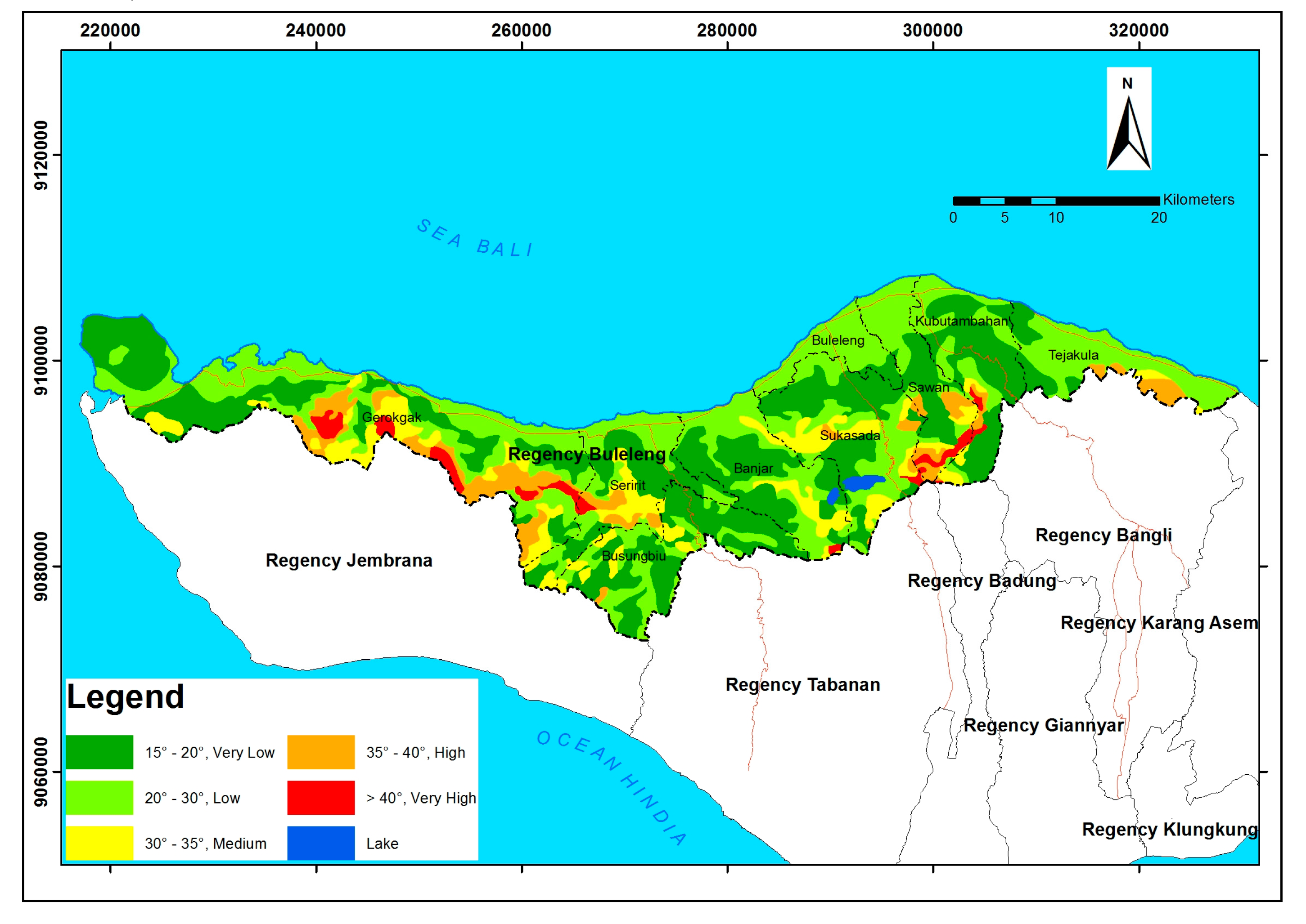
The analysis and assessment of the landslide hazards level are carried out first, and are then overlaid on each parameter map to obtain a hazard map. The slope inclination reached 14.68% in the C zone with the height of <500 m above sea level. Most of the regions were in zone B and C and this condition is shown in 
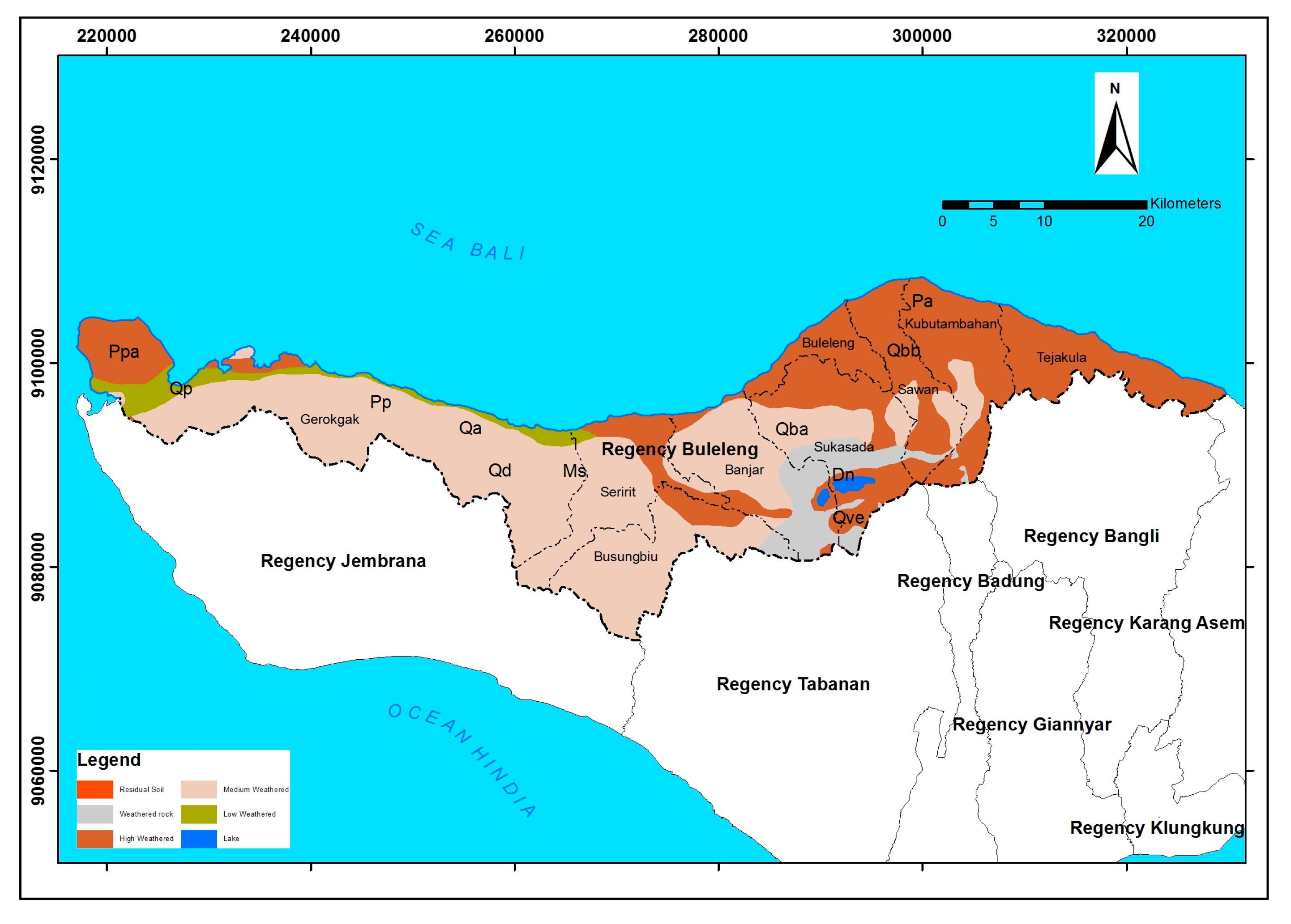
Figure 5. Areas with thick soil had the potential for higher soil or rock movement. The identification of rock weathering was seen from the matrices of the surrounding fresh rock, the greater intensity of the matrix means the rock had been weathered in moderate intensity [20]. The level of rocks weathering of slope constituent can be seen in Figure 6.
The fracture was the perpendicular distance between two consecutive fractures along the stretch line. The geological structure of the study area was distinguished by the fracture distance in an area which was divided into very dense, dense, medium, wide, and very wide categories [21,22]. The conditions of the geological structure can be seen in Figure 7.
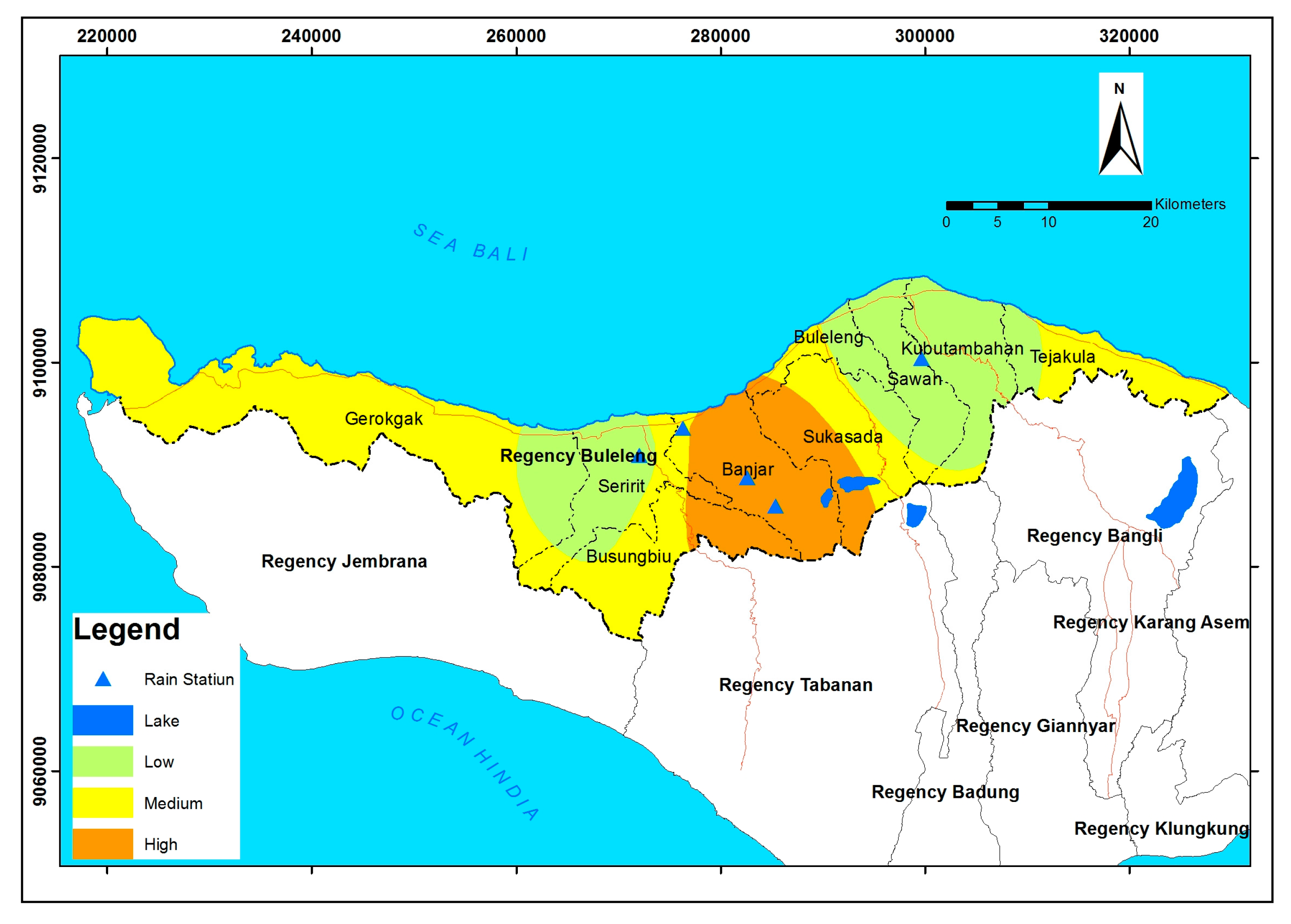
The rainfall parameter was measured in the annual average. Furthermore, the isohyet method was used to calculate the rainfall intensity based on rainfall station data in the research area. The map of rainfall intensity was based on rainfall data from four observation stations from 1994 to 2016. Rainfall intensity can be seen in Figure 8.
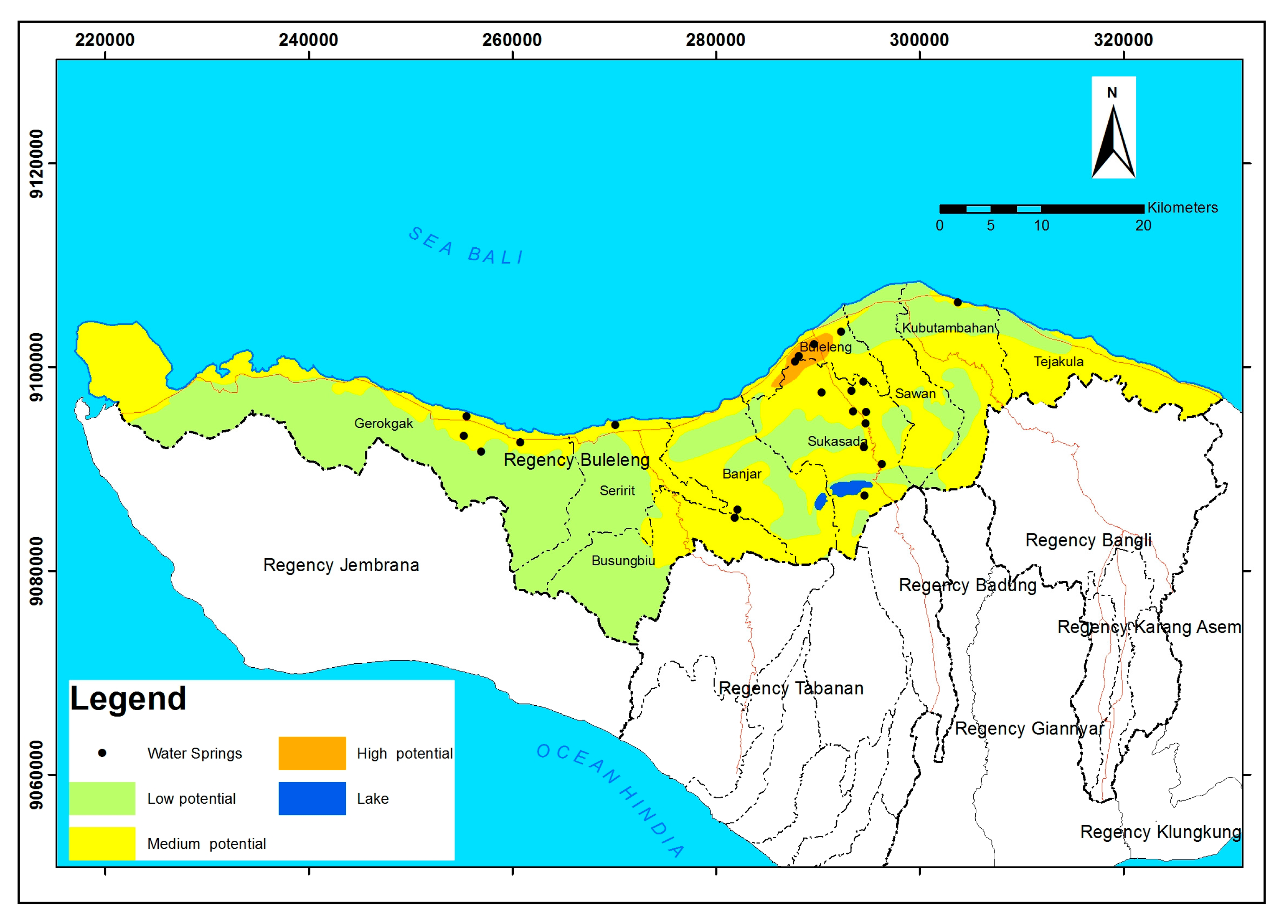
The groundwater potential in the research area was classified into five types based on the neighborhood units of Bali province. The groundwater potential was high when the rocks were tuffs on vesicular lava or were brick residual volcanic rocks. The medium groundwater potential was found in alluvium soil types. The groundwater potential was low and located in swamp sediment alluvium (coastal plains, a deposition result of tertiary rock). The underground water potential was rare at the top of the volcano in the rocks. The explanation of groundwater conditions can be seen in Figure 9.
The seismic model review map was reviewed based on the 2010 hazard map of Indonesia earthquakes issued by the Ministry of Public Works using the peak ground acceleration (PGA) in the bedrock (SB) for probability exceeding 2% within 50 years of building service life or corresponding to an earthquake return period of 2475 years [23]. The review of seismic conditions can be seen in Figure 10.
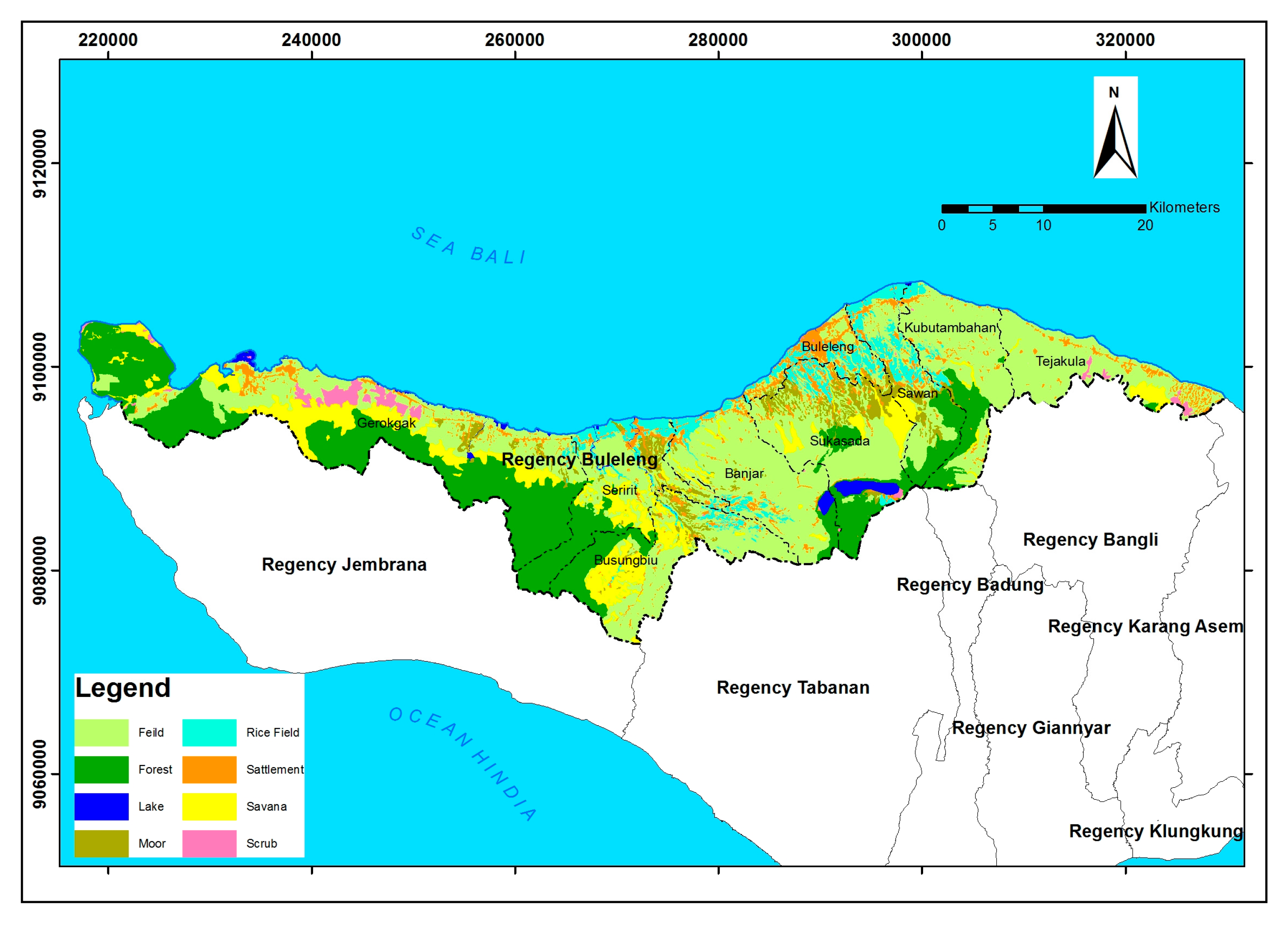
Based on the Indonesia Topography Map of Bali Province with a scale of 1:25,000, vegetation coverage classes were categorized into: shrubs, forests, fields, grasslands, plantations, irrigated paddy fields, and rain-fed rice fields. Land usage types such as rice fields or moor and scrub, especially in areas that have steep land, usually experience frequent landslides. Figure 11 shows the vegetation coverage of the research area.
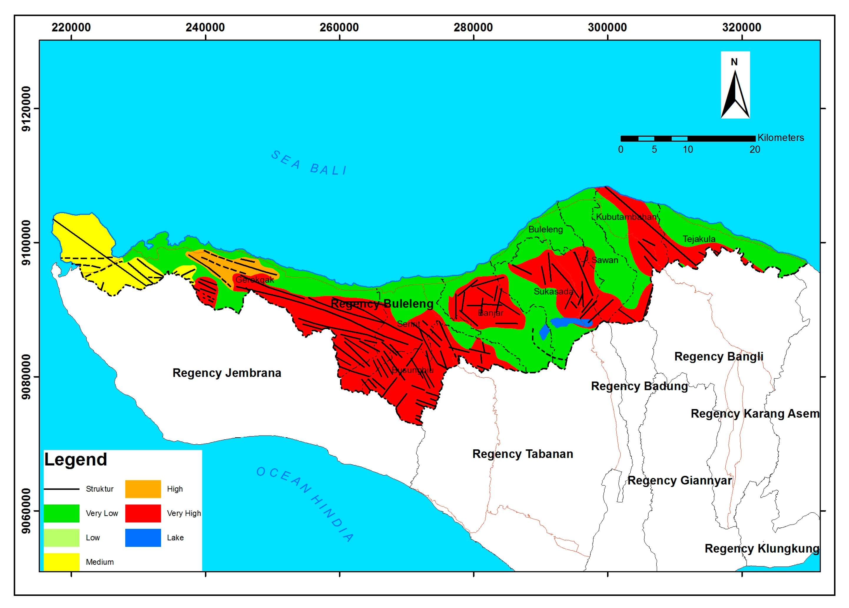
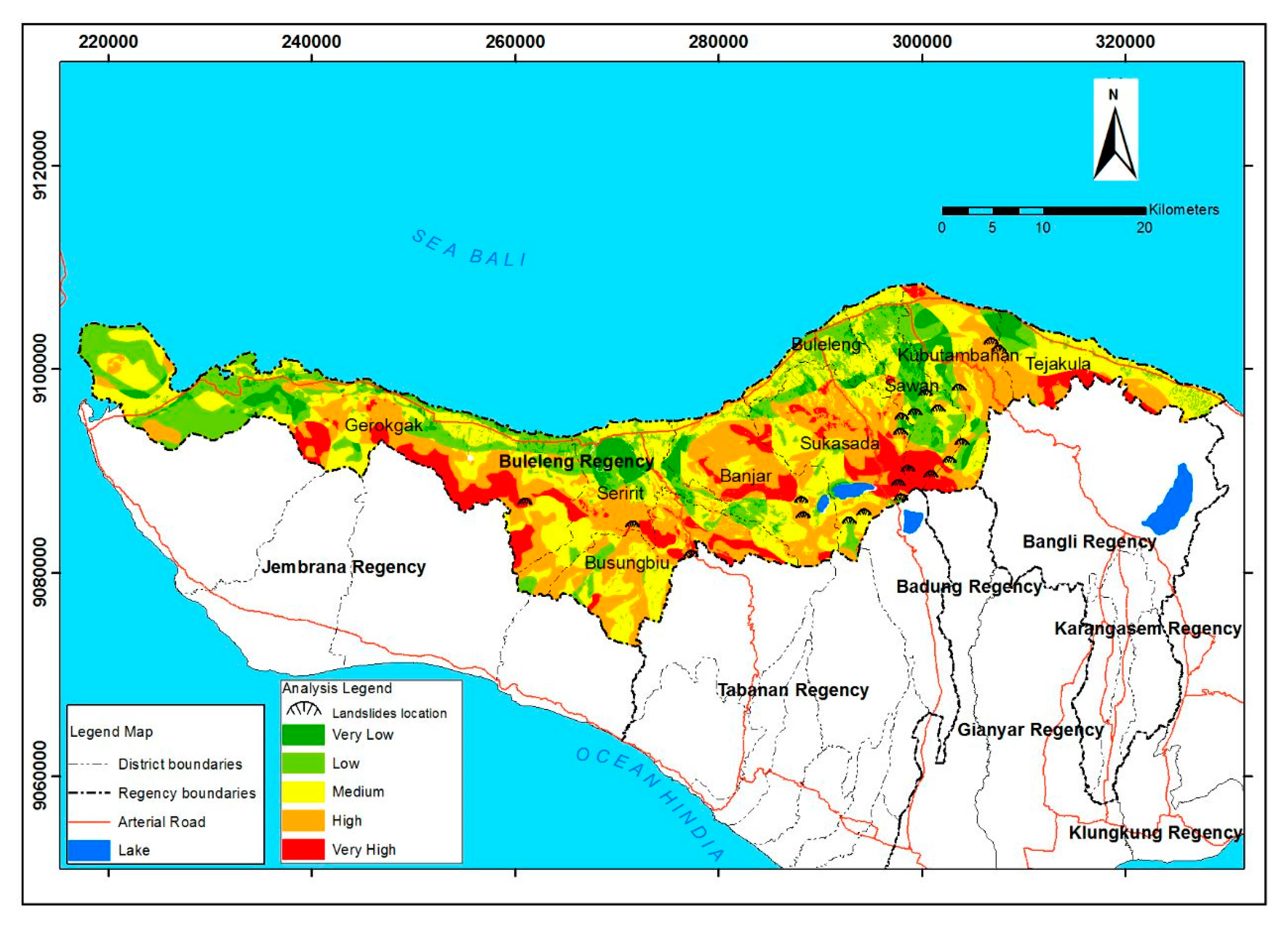
The overlay between trigger parameters map produced a soil movement hazard map as shown in Figure 12, as well as a mass movement hazard index value ranging from very low to very high hazard levels, with a mass movement hazard scale interval in each zone as shown in Table 5. High and very high threats were mostly located in the B (33.46%) and C (19.25%) zones of the total area of the Buleleng district. In the ancient mountainous regions of the Buyan-Tamblingan region in the Sukasada sub-district, the soil movement hazard level was very high because it is located in the C zone and has a high level of rainfall.

4. Conclusions

Deterministic modeling with SINMAP combining geotechnical factors and a slope hydrological model with geomorphological approaches gives an evenly distributed classification of soil movement hazards. At high and very high hazard levels, this model only gives validation equal to 14.29%, whereas the overlay method with trigger parameters of soil movement yields a validation of 71.43%, as shown in Table 6.
The use of parameters for study is a method that provides far more accurate results than the SINMAP deterministic method. The SINMAP deterministic model is limited to actual landslide modeling because it is based solely on test results and calculations of soil geotechnical parameters and the quality of DEM data used. In other words, the SINMAP deterministic model performs poorly for a wide range of heterogeneous land characteristics.
The results of this study support the use of weighting parameters, with weight percentages as given previously, as the results of the survey are quite extensive. Weighting also allows for modifications according to the characteristics of the study area, beginning with geotechnical observations and investigations. The analytic hierarchy process (AHP) method allows for a high level of modification of the weighting scale for each of the parameters, and this is greatly influenced by the experience of the researcher as well as environmental conditions.

Acknowledgments

The authors would like to thank the Soil Mechanics Laboratory of Universitas Gadjah Mada and the Civil Engineering Department of Warmadewa University for granting permission to use the equipment. Our gratitude also goes to the Pusdalop Bali Province and Disaster Management Agency (BPBD) of Buleleng district who provided much data and access to research in the region. Great appreciation is also given to Ministry of Research, Technology, and Higher Education of the Republic of Indonesia and the Korpri Welfare Foundation of Bali Province and for the financial support.

Author Contributions

I Nengah Sinarta performed all the experiments and analyzed the data. Ahmad Rifa’i (promotor) supervised this work, partly conducted the experiments, and analyzed the data. Teuku Faisal Fathani (co-promotor) guided the work on landslide hazards. Wahyu Wilopo (co-promotor), as a geologist, guided how to proceed with respect to geology hazards.

Conflicts of Interest

The authors declare no conflict of interest

References

  1. Gorsevski, P.V.; Gessler, P.E.; Boll, J.; Elliot, W.J.; Foltz, R.B. Spatially and temporally distributed modelling of landslide susceptibility. Geomorphology 2006, 80, 178–198. [Google Scholar] [CrossRef]
  2. Hadmoko, G.S.; Lavigne, F.; Sartohadi, J.; Hadi, P.; Winaryo. Landslide hazard and risk assessment and their application in risk management and landuse planning in eastern flank of Menoreh Mountains, Yogyakarta Province, Indonesia. Nat. Hazards 2010, 54, 623–642. [Google Scholar] [CrossRef]
  3. Van Westen, C.J.; Rengers, N.; Soeters, R. Use of geomorphological information in indirect landslide susceptibility assessment. Nat. Hazards 2003, 30, 399–419. [Google Scholar] [CrossRef]
  4. Van Westen, C.J.; Soeters, R. Landslide hazard and risk zonation—Why is it still so difficult? Bull. Eng. Geol. Environ. 2005, 65, 167–184. [Google Scholar] [CrossRef]
  5. Paulin, L. Effect of pixel size on cartographic representation of shallow and deep-seated landslide, and its collateral effects on forecasting of landslides by SINMAP and Multiple Logistic Regression landslide models. Phys. Chem. Earth 2010, 35, 137–148. [Google Scholar] [CrossRef]
  6. Wang, H.; Gangjun, L.; Weiya, X.; Gonghui, W. GIS-based landslide hazard assessment: An overview. Prog. Phys. Geogr. 2005, 29, 548–567. [Google Scholar]
  7. Meisina, C.; Scarabelli, S. A comparative analysis of terrain stability models for predicting shallow landslides in colluvial soils. Geomorphology 2007, 87, 207–223. [Google Scholar] [CrossRef]
  8. Bemmelen, R.W. The Geology of Indonesia; Martinus Nyhoff: The Haque, The Nederlands, 1949; Volume I A. [Google Scholar]
  9. Sinarta, I.N.; Rifa’i, A.; Fathani, T.F.; Wilopo, W. Geotechnical Properties and Geology Age on Characteristics of Landslides Hazards of Volcanic Soils in Bali, Indonesia. Int. J. Geomate 2016, 11. [Google Scholar] [CrossRef]
  10. Thornbury, W.D. Principles of Geomorphology; John Wiley and Sons, Inc.: New York, NY, USA, 1958. [Google Scholar]
  11. Hardiyatmo, H.C. Tanah Longsor dan Erosi; Gadjah Mada University Press: Yogyakarta, Indonesia, 2012; Volume 2. [Google Scholar]
  12. Fathani, T.F.; Legono, D.; Karnawati, D. A Numerical Model for the Analysis of Rapid Landslide Motion. Geotech. Geol. Eng. 2017, 1–16. [Google Scholar] [CrossRef]
  13. Purbo-Hadiwidjojo, M.M.; Samodra, H.; Amin, T. Peta Geologi Lembar Bali, Nusa Tenggara; Pusat Penelitian dan Pengembangan Geologi: Bandung, Indonesia, 1998. [Google Scholar]
  14. Pusat Pengendalian Operasi (Pusdalop); Badan Penanggulangan Bencana Daerah, Provinsi Bali: Jakarta, Indonesia, 2012.
  15. Ministry of Public Works. Guideline for the Spatial Planning of Disaster Prone Area; Ministry of Public Works Decree No.22/PRT/M/2007; Directorate General for Spatial Planning: Jakarta, Indonesia, 2007.
  16. Varnes, D.J. Slope movement types and processes. In Landslide: Analysis and Control; Schuster, R.L., Krizek, R.J., Eds.; Transportation Research Board, National Research Council: Washington, DC, USA, 1978; pp. 11–33. [Google Scholar]
  17. Kayastha, P. Slope Stability Analysis Using GIS on a Regional Scale. Master’s Thesis, Vrije Universiteit Brussels, Ixelles, Belgium, 2006; p. 112. [Google Scholar]
  18. Pack, R.T. A Stability Index Approach to Terrain Stability Hazard Mapping, SINMAP User’s Manual; Canadian Forest Products Ltd.: Vancouver, BC, Canada, 2005. [Google Scholar]
  19. Pack, R.T. SINMAP 2 A Stability Index Approach to Terrain Stability Hazard Mapping; David Tarboton, Utah State University: Logan, UT, USA, 2005. [Google Scholar]
  20. Santi, P.M. Field Methods for Characterizing Weak Rock for Engineering. Environ. Eng. Geosci. 2006, 12, 1–11. [Google Scholar] [CrossRef]
  21. Bieniawski, Z.T. Engineering Rock Mass Classifications; John Wiley and Sons: Etobicoke, ON, Canada, 1989. [Google Scholar]
  22. Karnawati, D. Basic Concept on Landslide Mapping; Department of Geological Engineering, Gadjah Mada University: Yogyakarta, Indonesia, 2002. [Google Scholar]
  23. Irsyam, M.; Sengara, W.; Aldiamar, F.; Widiyantoro, S.; Triyoso, W.; Hilman, D.; Kertapati, E.; Meilano, I.; Suhardjono, A.; Ridwan, D.H.; et al. Development of Seismic Hazard and Risk Maps for New Seismic Building and Infrastructure Codes in Indonesia. In Proceedings of the 6th Civil Engineering Conference in Asia Region: Embracing the Future through Sustainability, Jakarta, Indonesia, 20–22 August 2013. [Google Scholar]
Figure 1. Landslide area in the Buleleng district.
Geosciences 07 00110 g001
Figure 2. Infinite slope.
Geosciences 07 00110 g002
Figure 3. Hazard map of landslides using Soil Stability Index Mapping (SINMAP).
Geosciences 07 00110 g003
Figure 4. Graph of the slope-area (S–A) of Buleleng.
Geosciences 07 00110 g004
Figure 5. Slope inclination on the study area.
Geosciences 07 00110 g005
Figure 6. Rock weathering on the study area.
Geosciences 07 00110 g006
Figure 7. Geological structure on the study area.
Geosciences 07 00110 g007
Figure 8. Rainfall intensity on the study area.
Geosciences 07 00110 g008
Figure 9. Groundwater potential on the study area.
Geosciences 07 00110 g009
Figure 10. Seismicity model of the study area.
Geosciences 07 00110 g010
Figure 11. Vegetation coverage of the study area.
Geosciences 07 00110 g011
Figure 12. Hazard map of landslides using trigger parameters.
Geosciences 07 00110 g012
Table 1. Classes as per the soil stability index. SI: stability index.
SI ConditionClassCondition
>1.51Stable slope zone
1.5–1.252Slightly stable slope zone
1.24–1.03Less stable slope zone
0.9–0.54Landslide lower threshold zone
0.4–0.15Landslide upper threshold zone
0.06Landslide slope zone
Table 2. Results of soil investigation.
No.LocationCohesion (c) kPaInternal Friction Angle (φ)o
Lower BoundUpper BoundLower BoundUpper Bound
1.Gerokgak village0.4270.88530.2535.38
2.Sambangan village0.7560.82837.1039.63
3.Buleleng village0.3440.56118.9929.28
4.Manpower of Buleleng0.5000.92926.5742.88
5.Panarukan village0.3440.82518.9939.52
6.Banyuning village0.4330.93823.8943.15
7.Banyuatis village0.5100.91934.0242.58
8.Banjar village0.6450.87640.0243.41
9.Seririt village0.1210.21645.4549.50
10.Pancasari village0.1520.1933.6334.56
Table 3. Statistical results of the stability index of landslide hazards in the Buleleng district.
Slope Stability LevelStableModerately StableQuasi-StableLower ThresholdUpper ThresholdDefendedTotal
Stability Index>1.51.25–1.51–1.250.5–10.001–0.5<0
Total area (ha)93,64018,09011,78412,831.00253.100136,598.10
Area percentage (%)68.5513.248.639.390.190100.00
Number of landslides003135021
Landslide percentage0014.2961.9023.810100.00
Landslide density000.00030.0010.0200.0213
Table 4. The sensitivity level of landslides hazards in each zone based on Regulation No. 22/PRT/M/2007. Mean sea water level (m.swl).
IndicatorWeighted (%)ScoringDescription
Typology ATypology BTypology C
Mountainous Area Slopes, Hillsides, Hill Slopes, and River Cliffs, with a Slope of >40%, and Altitudes >2000 m.swlThe Foot of the Mountainous Areas, with a Slope Ranging between 21% and 40%, with a Height of 500–2000 m.swl.Zones in Plateaus, Lowlands, River Cliffs, or River Valleys with Slope Ranging from 0 to 20%, and a Height of 0–500 m.swl
Slope inclination305Slope inclination >40°Slope inclination >40°-
4Relatively convex slopes, steeper slope of 35°–40°Relatively convex slopes, steeper slope of 35°–40°Relatively convex slopes, steeper slope of 35°–40°
3Slope inclination 35°–40°Slope inclination 35°–40°Slope inclination 35°–40°
2Slope inclination 20°–30°Slope inclination 20°–30°Slope inclination 20°–30°
1Slope inclination 15°–20°Slope inclination 15°–20°Slope inclination 15°–20°
Rock weathering155-RegosolRegosol
4Andosol, grumosolAndosol, grumosolAndosol, grumosol
3Brown forest soilBrown forest soilBrown forest soil
2LatosolLatosolLatosol
1AluuvialAluuvialAluuvial
Geological structure205Very wide >2 mVery wide >2 mVery wide >2 m
4Wide 0.6–2 mWide 0.6–2 mWide 0.6–2 m
3Moderate 0.2–0.6 mModerate 0.2–0.6 mModerate 0.2–0.6 m
2Close 0.006–0.2 mClose 0.006–0,2 mClose 0.006–0.2 m
1Very close <0.006 mVery close <0.006 mVery close <0.006 m
Rainfall155Rainfall reaches 100 mm/day with annual rainfall >5500 mmRainfall reaches 100 mm/day with annual rainfall >5500 mmRainfall reaches 100 mm/day with annual rainfall >5500 mm
4Rainfall <100 mm/day with annual rainfall 4500–5500 mmRainfall <100 mm/day with annual rainfall 4500–5500 mmRainfall <100 mm/day with annual rainfall 4500–5500 mm
3Rainfall <100 mm/day with annual rainfall 3500–4500 mmRainfall <100 mm/day with annual rainfall 3500–4500 mmRainfall <100 mm/day with annual rainfall 3500–4500 mm
2Rainfall <100 mm/day with annual rainfall 2500–3500 mmRainfall <100 mm/day with annual rainfall 2500–3500 mmRainfall <100 mm/day with annual rainfall 2500–3500 mm
1Annual rainfall <2500 mmAnnual rainfall <2500 mmAnnual rainfall <2500 mm
Ground water potential75High groundwater potentialHigh groundwater potentialHigh groundwater potential
4High–medium potential groundwaterHigh–medium potential groundwaterHigh–medium potential groundwater
3Medium groundwater potentialMedium groundwater potentialMedium groundwater potential
2Low groundwater potentialLow groundwater potentialLow groundwater potential
1Potential groundwater is scarcePotential groundwater is scarcePotential groundwater is scarce
Seismicity340.4–0.5 g0.4–0.5 g0.4–0.5 g
30.3–0.4 g0.3–0.4 g0.3–0.4 g
Vegetation105Irrigated rice fieldsIrrigated rice fieldsIrrigated rice fields
4Rain-fed rice fieldsRain-fed rice fieldsRain-fed rice fields
3Plantations, fieldsPlantations, fieldsPlantations, fields
2ForestForestForest
1Rocky ground, bush, savannaRocky ground, bush, savannaRocky ground, bush, savanna
Table 5. Results with respect to areas and percentages at each hazard level.
Hazard LevelIntervalZone A (>2000 m.swl)Zone B (500–2000 m.swl)Zone C (<500 m.swl)Total
Area (ha)%Area (ha)%Area (ha)%
Very high1.70–3.0022.450.029215.346.754067.402.9813,305.19
High1.11–1.7000.0022,821.6416.7122,217.3616.2745,039.00
Medium0.64–1.103.340.0011,514.518.4327,260.9219.9638,778.77
Low0.18–0.6300.007327.835.3620,489.8115.0027,817.64
Very low0.00–0.1700.002419.871.779228.216.7611,648.08
Total 25.790.0253,299.1939.0283,263.7060.96136,588.68
Table 6. Validation of the number of landslide events.
No.Sensitivity ClassTrigger ParametersSINMAP
Landslide (%)Landslide(%)
1Very high419.0500
2High1152.38314.29
3Medium523.811361.90
4Low14.76523.81
5Very low00.0000.00
Sub total2110021100

