Origin of Knickpoints in an Alpine Context Subject to Different Perturbing Factors, Stura Valley, Maritime Alps (North-Western Italy)


Abstract
:1. Introduction
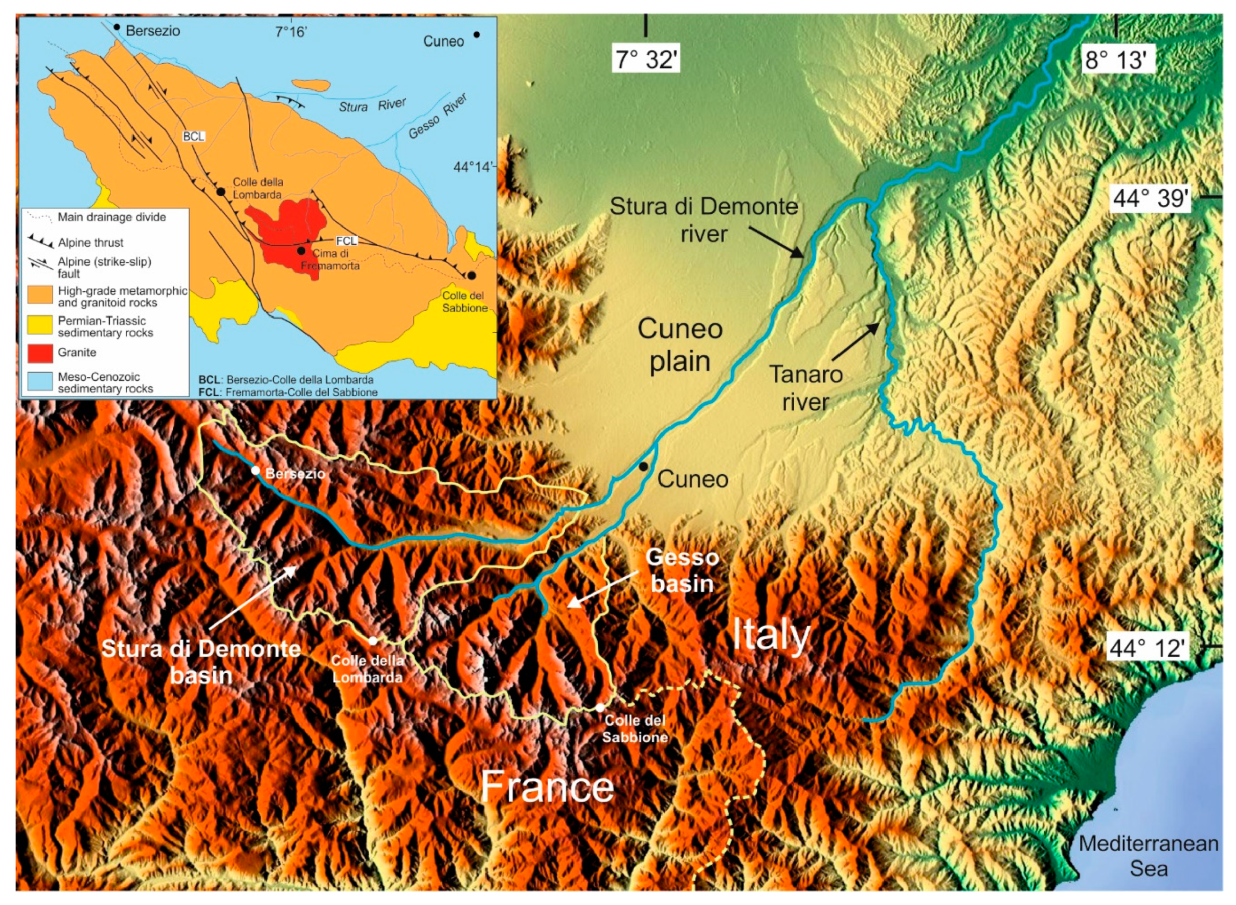
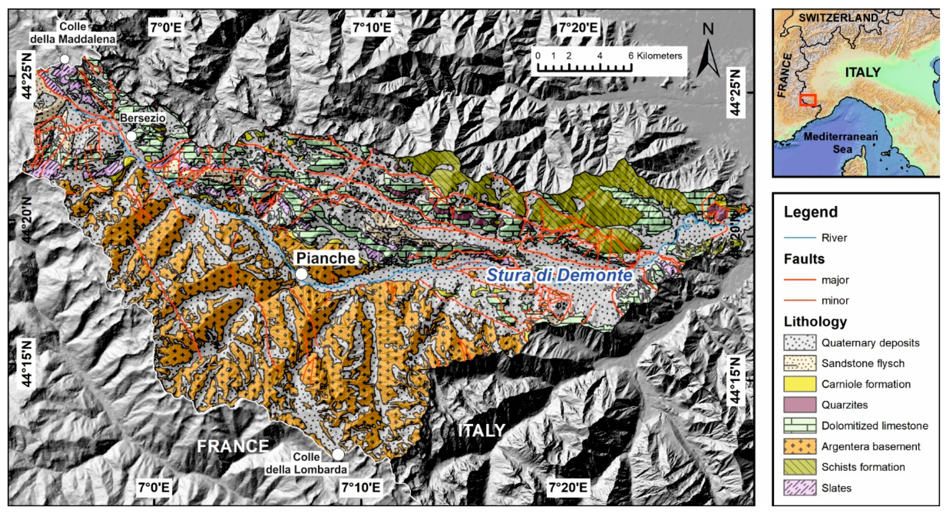
2. Regional Setting
3. Methods
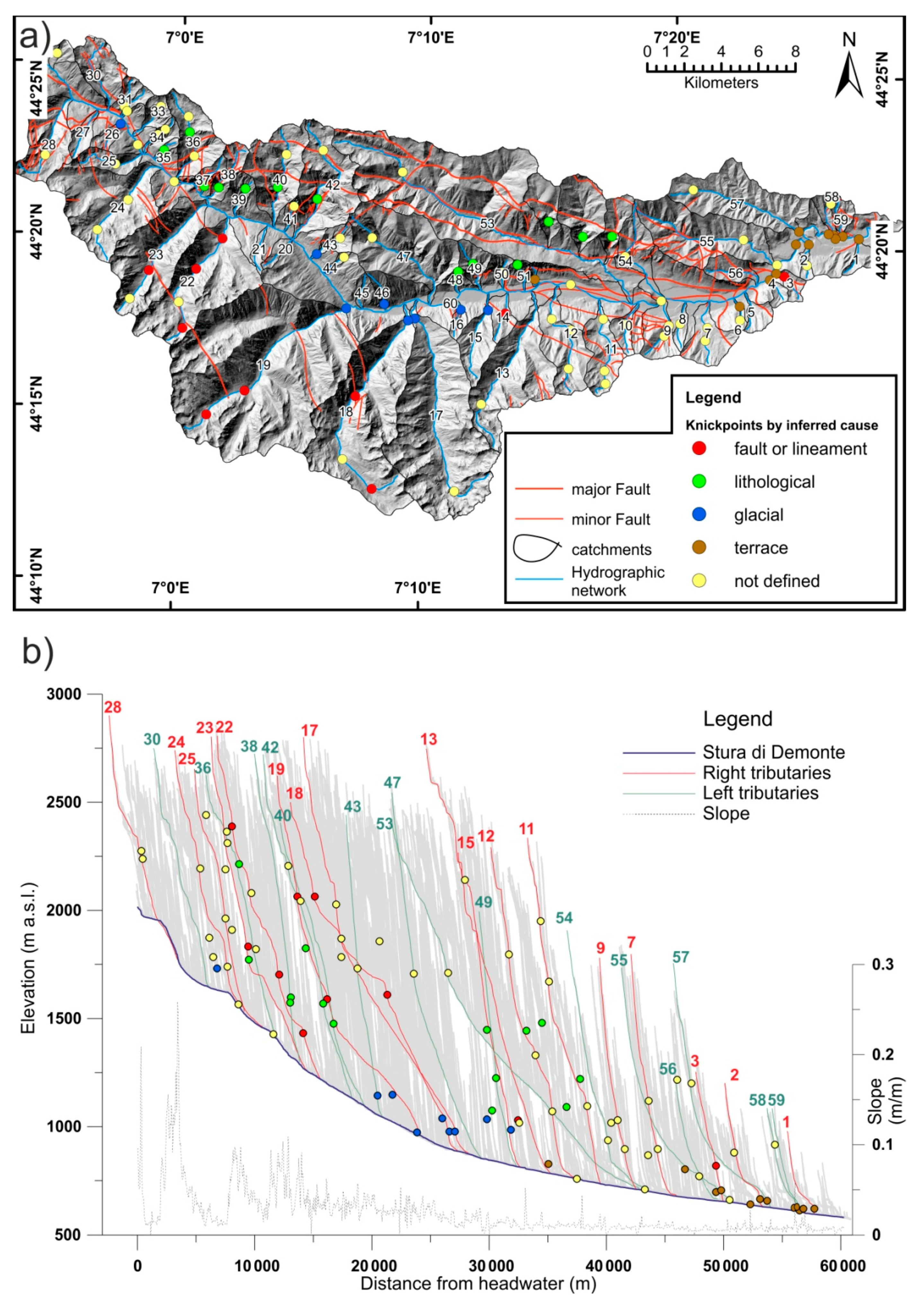
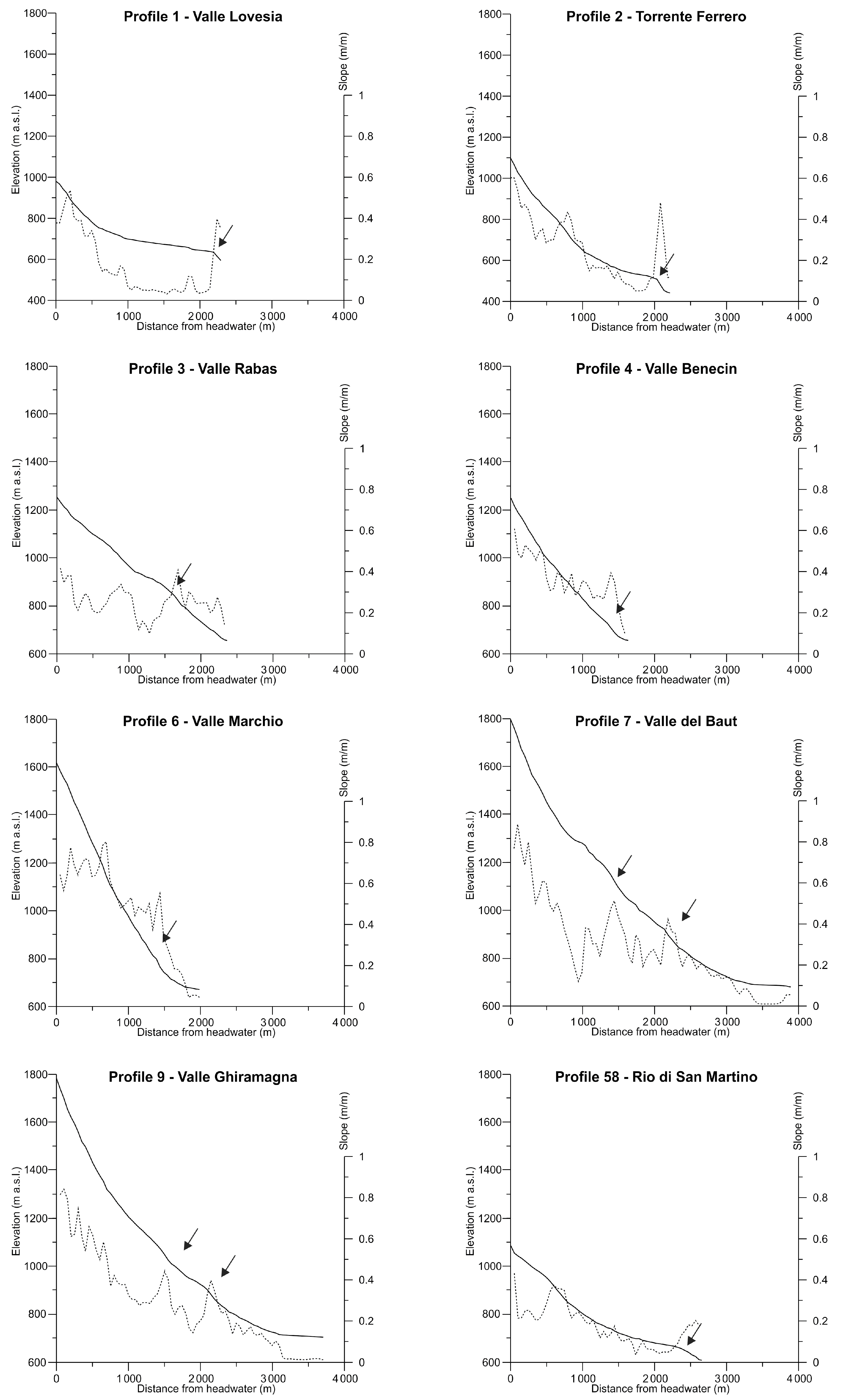
4. Results
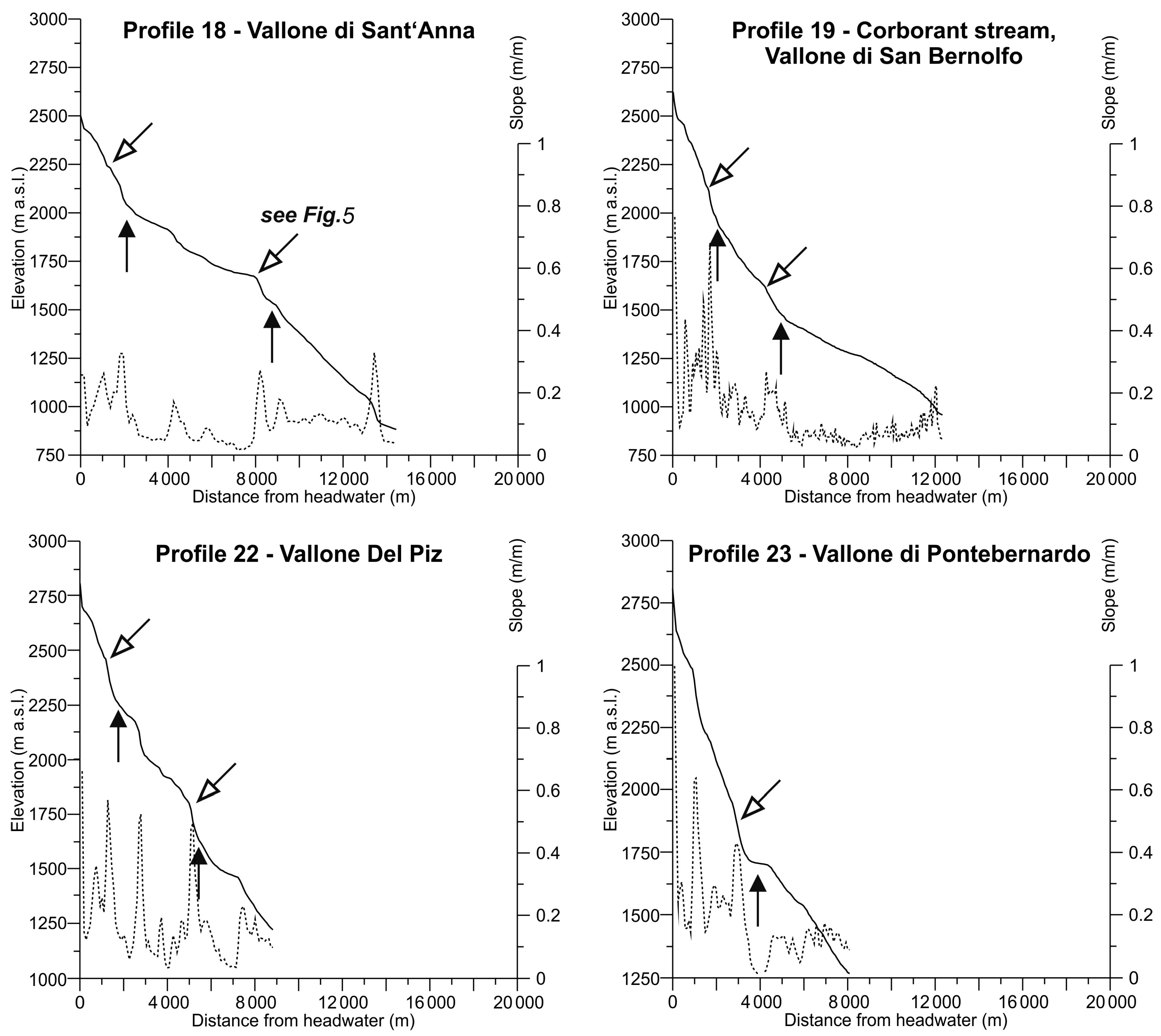
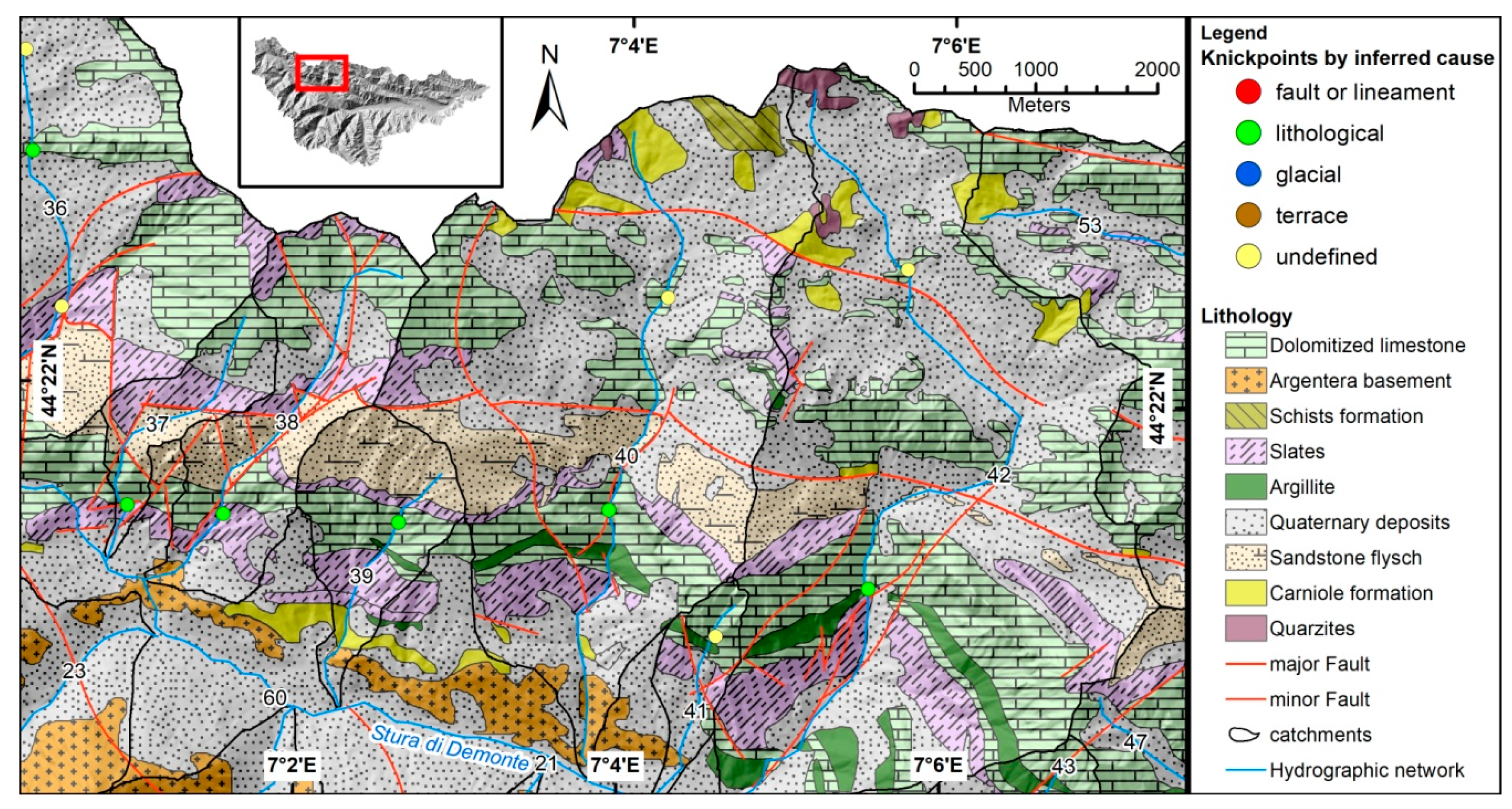
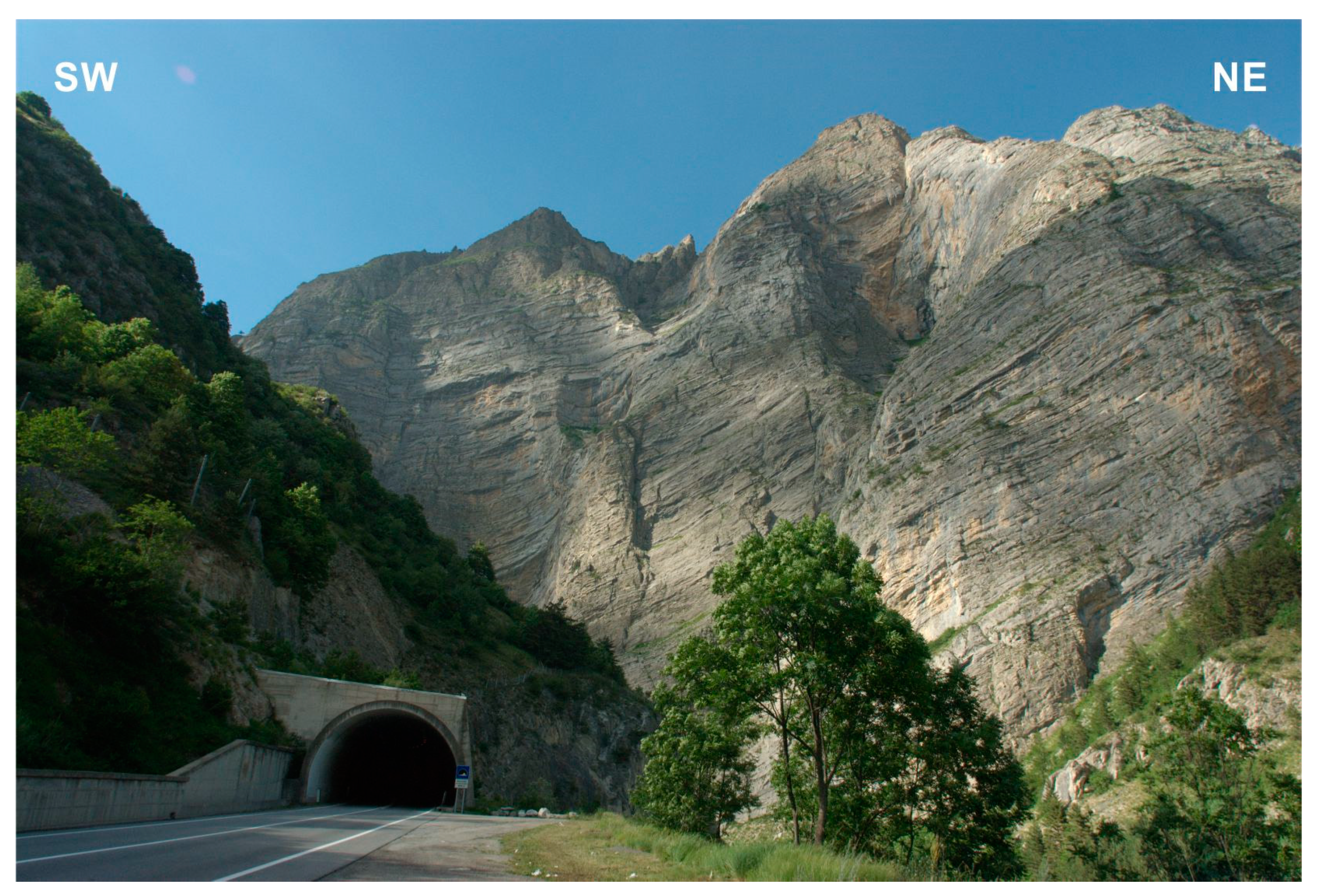
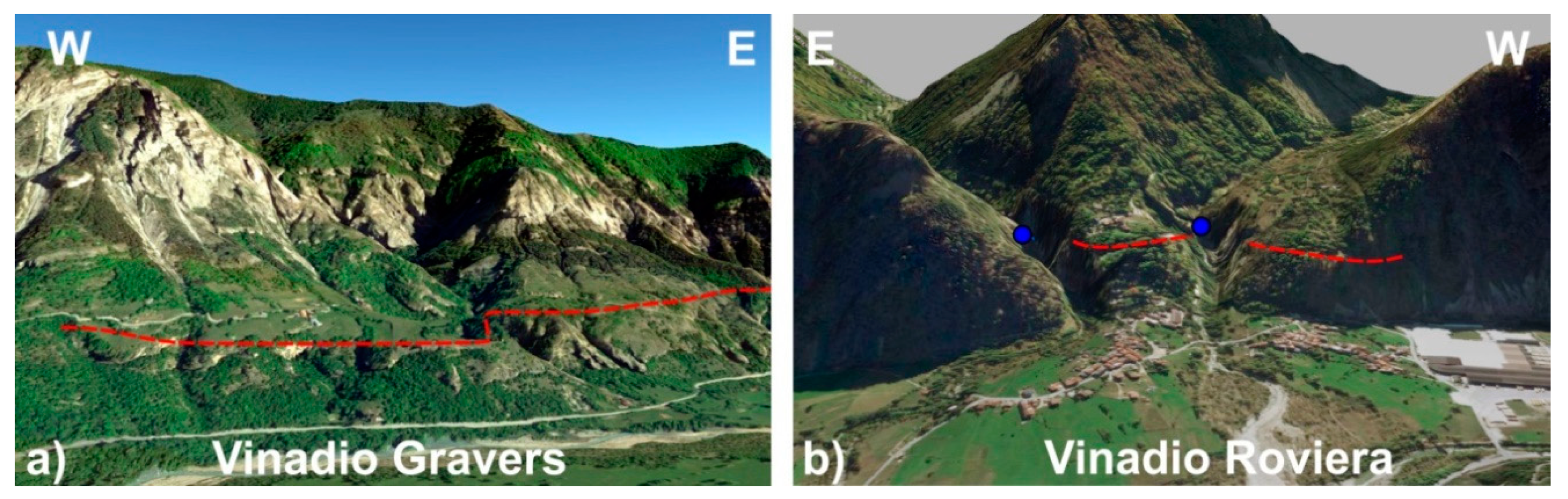
4.1. Knickpoints Related to Faults
4.2. Knickpoints Related to Lithological Contrasts
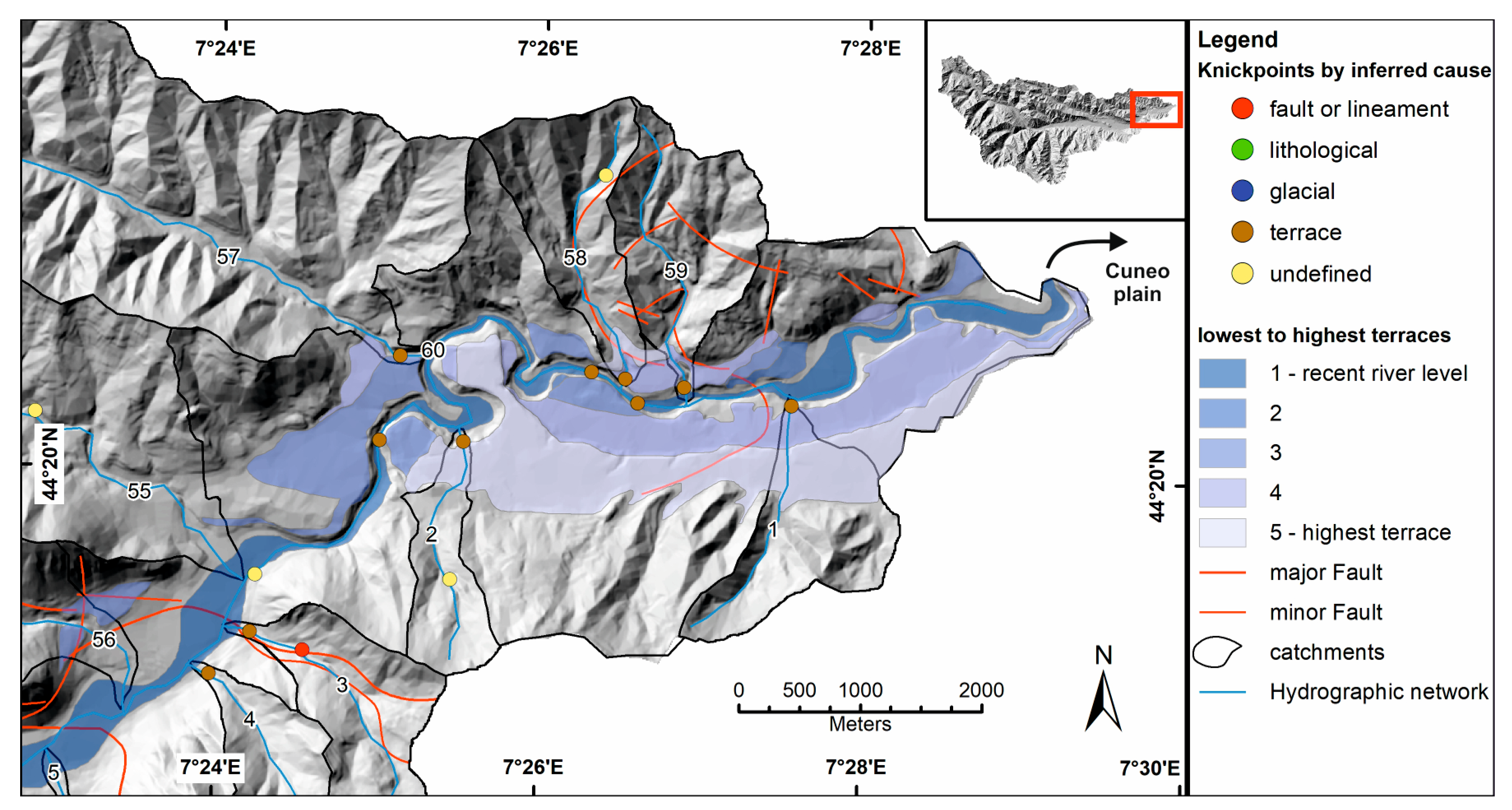
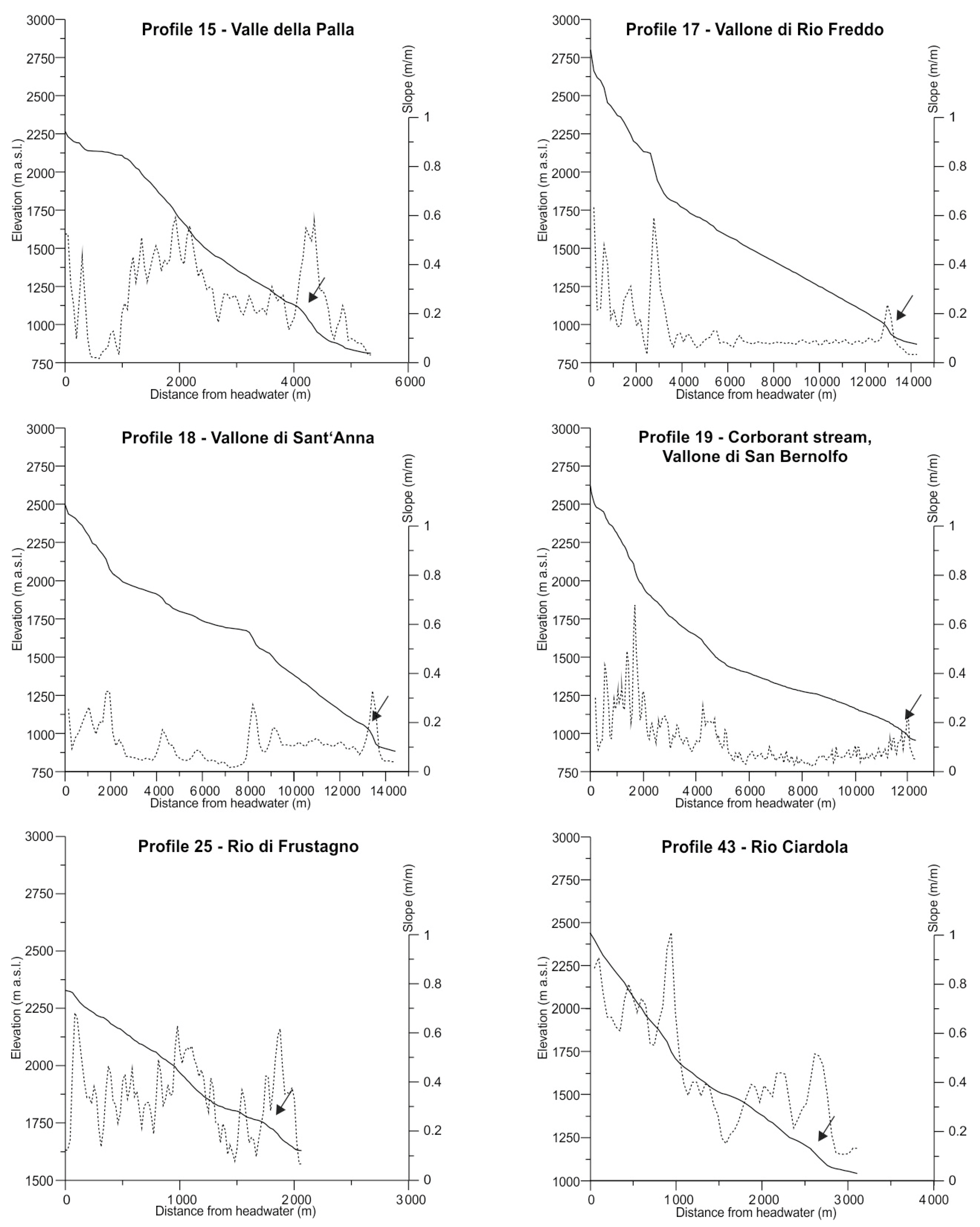
4.3. Knickpoints Related to Base-Level Change
4.4. Knickpoints Related to Glacial Residual Morphologies
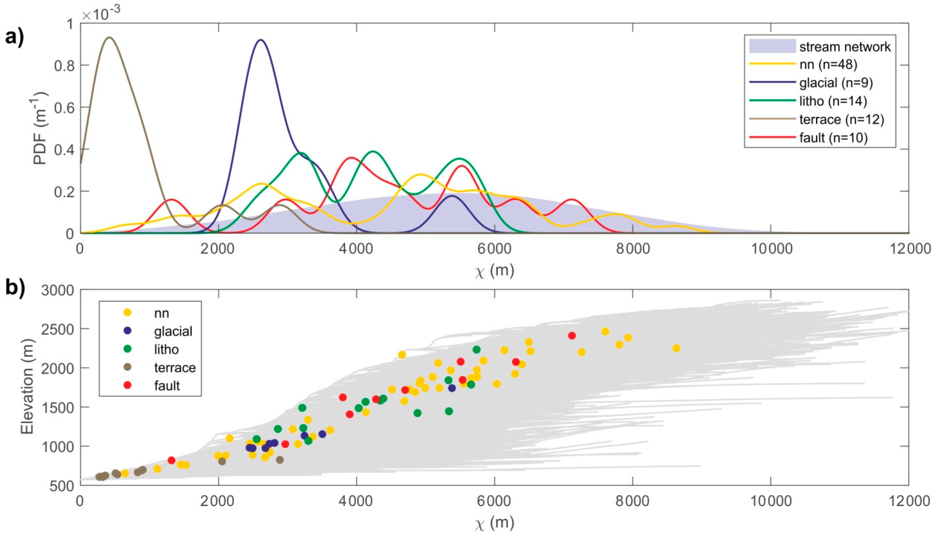
4.5. X-Analysis
5. Discussion and Conclusions
Author Contributions
Funding
Acknowledgments
Conflicts of Interest
References
- Burbank, D.W.; Anderson, R.S. Tectonic Geomorphology; Blackwell Scientific: Oxford, UK, 2001; 270p. [Google Scholar]
- Duvall, A.; Kirby, E.; Burbank, D. Tectonic and lithologic controls on bedrock channel profiles and processes in coastal California. J. Geophys. Res. 2004, 109, F03002. [Google Scholar] [CrossRef]
- Pearce, S.A.; Pazzaglia, F.J.; Eppes, M.C. Ephemeral stream response to growing folds. Geol. Soc. Am. Bull. 2004, 116, 1223–1239. [Google Scholar] [CrossRef]
- Bishop, P.; Hoey, T.B.; Jansen, J.D.; Artza, I.L. Knickpoint recession rate and catchment area: The case of uplifted rivers in Eastern Scotland. Earth Surf. Proc. Land. 2005, 30, 767–778. [Google Scholar] [CrossRef]
- Carretier, S.; Nivière, B.; Giamboni, M.; Winter, T. Do river profiles record alongstream variations of low uplift rate? J. Geophys. Res. 2006, 111, 1–16. [Google Scholar] [CrossRef]
- Mackin, J.H. Concept of the graded river. Geol. Soc. Am. Bull. 1948, 59, 463–512. [Google Scholar] [CrossRef]
- Hack, J.T. Studies of Longitudinal Stream Profiles in Virginia and Maryland; US Government Printing Office: Washington, DC, USA, 1957; Volume 294, pp. 45–97.
- Howard, A.D.; Dietrich, W.E.; Seidl, M.A. Modeling fluvial erosion on regional to continental scales. J. Geophys. Res. 1994, 99, 13971–13986. [Google Scholar] [CrossRef]
- Whipple, K.X.; Tucker, G.E. Dynamics of the Stream Power River Incision Model: Implications for Height Limits of Mountain Ranges, Landscape Response Timescales and Research Needs. J. Geophys. Res. 1999, 104, 17661–17674. [Google Scholar] [CrossRef]
- Richard, K.S. Rivers: Form and Process in Alluvial Channels; Methuen: London, UK, 1982; 358p. [Google Scholar]
- Knighton, A.D. Fluvial Forms and Processes: A New Perspective; Arnold: London, UK, 1998; 383p. [Google Scholar]
- Schumm, S.A. River Variability and Complexity; Cambridge University Press: New York, NY, USA, 2005; 200p. [Google Scholar]
- Crosby, B.T.; Whipple, K.X. Knickpoint initiation and distribution within fluvial networks: 236 waterfalls in the Waipaoa River, North Island, New Zealand. Geomorphology 2006, 82, 16–38. [Google Scholar] [CrossRef]
- Larue, J.P. Effects of tectonics and lithology on long profiles of 16 rivers of the southern Central Massif border between the Aude and the Orb (France). Geomorphology 2008, 93, 343–367. [Google Scholar] [CrossRef]
- Phillips, J.D.; Lutz, J.D. Profile convexities in bedrock and alluvial streams. Geomorphology 2008, 102, 554–566. [Google Scholar] [CrossRef]
- Phillips, J.D.; McCormack, S.; Duan, J.; Russo, J.P.; Schumacher, A.M.; Tripathi, G.N.; Brockman, R.B.; Mays, A.B.; Pulugurtha, S. Origin and interpretation of knickpoints in the Big South Fork River basin, Kentucky–Tennessee. Geomorphology 2010, 114, 188–198. [Google Scholar] [CrossRef]
- Royden, L.; Perron, J.T. Solutions of the stream power equation and application to the evolution of river longitudinal profiles. J. Geophys. Res. 2013, 118, 1–22. [Google Scholar] [CrossRef]
- DiBiase, R.A.; Whipple, K.X.; Lamb, M.P.; Heimsath, A.M. The role of waterfalls and knickzones in controlling the style and pace of landscape adjustment in the western San Gabriel Mountains, California. Geol. Soc. Am. Bull. 2015, 127, 539–559. [Google Scholar] [CrossRef]
- Abbott, L.D.; Lundstrom, C.; Traub, C. Rates of river incision and scarp retreat in eastern and central Grand Canyon over the past half million years: Evidence for passage of a transient knickzone. Geosphere 2015, 11, 638–659. [Google Scholar] [CrossRef]
- Grimaud, J.L.; Paola, C.; Voller, V. Experimental migration of knickpoints: Influence of style of base-level fall and bed lithology. Earth Surf. Dyn. 2016, 4, 11–23. [Google Scholar] [CrossRef]
- Neely, A.B.; Bookhagen, B.; Burbank, D.W. An automated knickzone selection algorithm (KZ-Picker) to analyze transient landscapes: Calibration and validation. J. Geophys. Res.: Earth Surf. 2017, 122, 1236–1261. [Google Scholar] [CrossRef]
- Casarosa, N. Evoluzione Geomorfologica dell’Alta Valle Stura (Alpi Marittime). Master Thesis, University of Pisa, Pisa, Italy, 2001. [Google Scholar]
- Capitani, M. Evoluzione Geomorfologica Recente Della Media e Bassa Valle Stura (Alpi Marittime). Master Thesis, University of Pisa, Pisa, Italy, 2002. [Google Scholar]
- Spagnolo, M. The asymmetry of the middle and lower portions of the Vallone dell’Arma, Stura Valley (Maritime Alps). Atti Fisici 2005, 139, 3–16. [Google Scholar]
- Spagnolo, M. Illustrative notes of the Geomorphological Map of the Upper Arma Valley (Stura di Demonte Valley, Maritime Alps). Geogr. Fis. Dinam. Quat. 2007, 30, 117–125. [Google Scholar]
- Capitani, M.; Marrucci, M. The Demonte Terrace in the Stura Valley (Maritime Alps) between climatic changes and tectonic movements. Geogr. Fis. Dinam. Quat. 2008, 31, 5–12. [Google Scholar]
- Ribolini, A. Il ruolo morfostrutturale e morfoselettivo delle rocce milonitiche nella parte sud-orientale del Massiccio Cristallino dell’Argentera (Alpi Marittime). Boll. Soc. Geol. Ital. 1999, 117, 657–677. [Google Scholar]
- Ribolini, A. Relief distribution, morphology and Cenozoic differential uplift in the Argentera Massif (French-Italian Alps). Z. Geomorphol. 2000, 44, 363–378. [Google Scholar]
- Musumeci, G.; Ribolini, A.; Spagnolo, M. The effect of late Alpine tectonics in the morphology of the Argentera Massif (Western Alps, Italy–France). Quat. Int. 2003, 101, 191–201. [Google Scholar] [CrossRef]
- Ribolini, A.; Spagnolo, M. Drainage network geometry versus tectonics in the Argentera Massif (French-Italian Alps). Geomorphology 2008, 93, 253–266. [Google Scholar] [CrossRef]
- Saillard, M.; Petit, C.; Rolland, Y.; Braucher, R.; Bourlès, D.L.; Zerathe, S.; Revel, M.; Jourdon, A. Late Quaternary incision rates in the Vésubie catchment area (Southern French Alps) from in situ-produced 36Cl cosmogenic nuclide dating: Tectonic and climatic implications. J. Geophys. Res. Earth Surf. 2014, 119, 1121–1135. [Google Scholar] [CrossRef]
- Rolland, Y.; Petit, C.; Saillard, M.; Braucher, R.; Bourlès, D.; Darnault, R.; Cassol, D. Inner gorges incision history: A proxy for deglaciation? Insights from Cosmic Ray Exposure dating (10Be and 36Cl) of river-polished surfaces (Tinée River, SW Alps, France). Earth Planet. Sci. Lett. 2016, 457, 271–281. [Google Scholar] [CrossRef]
- Petit, C.; Goren, L.; Rolland, Y.; Bourlès, D.; Braucher, R.; Saillard, M.; Cassol, D. Recent, climate-driven river incision rate fluctuations in the Mercantour crystalline massif, southern French Alps. Quat. Sci. Rev. 2017, 165, 73–87. [Google Scholar] [CrossRef]
- Malaroda, R.; Carraro, F. Carta Geologica del Massiccio dell’Argentera alla scala 1:50.000 e note illustrative. Mem. Soc. Geol. Ital. 1970, 9, 557–663. [Google Scholar]
- Baietto, A.; Perello, P.; Cadoppi, P.; Martinotti, G. Alpine tectonic evolution and thermal water circulations of the Argentera Massif (South-Western Alps). Swiss J. Geosci. 2009, 102, 223–245. [Google Scholar] [CrossRef]
- Bonetto, S.M.R.; Facello, A.; Umili, G. A new application of CurvaTool semi-automatic approach to qualitatively detect geological lineaments. Environ. Eng. Geosci. 2017, 23, 179–190. [Google Scholar] [CrossRef]
- Bogdanoff, S. Evolution de la partie occidentale du Massif Cristallin Externe de l’Argentera. Place dans l’arc alpin. Geol. France 1986, 4, 433–453. [Google Scholar]
- Horrenberger, J.C.; Michard, A.; Werner, P. Le couloir de décrochement de Bersezio en Haute Stura, Alpes Externe, Italie, Structure de compression subméridienne. Sci. Géol. Bull. 1978, 31, 15–20. [Google Scholar] [CrossRef]
- Fry, N. Southwestward thrusting and tectonics of the western Alps. In Alpine Tectonics; Coward, M.P., Dietrich, D., Park, R.G., Eds.; Geological Society London Special Publication: London, UK, 1989; pp. 83–109. [Google Scholar]
- Perello, P.; Piana, F. Neogenic thrust and strike—Slip tectonics at the northen boundaty between the Argentera Massif and its metasedimentary cover. Quad. Geodin. Alp. Quat. 1997, 4, 205. [Google Scholar]
- Bigot-Cormier, F.; Poupeau, G.; Sosson, M. Dénudations différentielles du massif cristallin externe alpin de l’Argentera (SE de la France) révélées par thermochronologie sur traces de fission (apatites, zircons). C. R. Acad. Sci. Paris 2000, 300, 363–370. [Google Scholar]
- Bogdanoff, S.; Michard, A.; Mansour, M.; Poupeau, G. Apatite fission tracks analysis in the Argentera massif: Evidence of contrasting denudation rates in the External Crystalline Massifs of the Western Alps. Terra Nova 2000, 12, 117–125. [Google Scholar] [CrossRef]
- Bigot-Cormier, F. La Surrection du Massif Cristallin Externe de l’Argentera (France-Italie) et ses Relations avec la Déformation Pliocène de la Marge Nord-Ligure: Arguments Thermochronologiques (Traces de Fission), Géomorphologiques et Interprétations de Sismique Marine. Ph.D. Thesis, Université de Nice Sophia Antipolis, Nice, France, 2002. [Google Scholar]
- Frechet, J.; Pavoni, N. Etude de la sismicité de la zone brianconnaise entre Pelvoux et argentera (Alpes occidentales) à l’aide d’un réseau de stations portables. Eclogae Geol. Helv. 1979, 72, 763–779. [Google Scholar]
- Madeddu, B.; Bertoux, N.; Stephan, J.F. Champ de contraine post-pliocene et deformation recentes dans les Alpes sud-occidentales. Bull. Soc. Géol. France 1996, 8, 797–810. [Google Scholar]
- Calais, E.; Galisson, L.; Stéphan, J.; Delteil, J.; Deverchère, J.; Larroque, C.; Mercier de Lépinay, B.; Popoff, M.; Sosson, M. Crustal strain in the southern Alps, France, 1948–1998. Tectonophysics 2000, 319, 1–17. [Google Scholar] [CrossRef]
- Biancotti, A. L’evoluzione recente ed attuale di un tratto della alta Pianura Padana del Piemonte sud-occidentale. Mem. Acc. Naz. Lincei 1977, 14, 191–225. [Google Scholar]
- Biancotti, A. Il quaternario dell’area compresa fra Stura di Demonte e Tanaro (Piemonte sud occidentale). Acc. Naz. Lincei 1979, 3, 1–10. [Google Scholar]
- Biancotti, A. Rapporti tra morfologia e tettonica nella Pianura Cuneese. Geograf. Fis. Dinam. Quat. 1979, 2, 51–56. [Google Scholar]
- Finsinger, W.; Ribolini, A. Late glacial to Holocene deglaciation of the Colle del Vei del Bouc-Colle del Sabbione Area (Argentera Massif, Maritime Alps, Italy-France). Geograf. Fis. Dinam. Quat. 2001, 24, 141–156. [Google Scholar]
- Ribolini, A.; Chelli, A.; Guglielmin, M.; Pappalardo, M. Relationships between glacier and rock glacier in the Maritime Alps, Schiantala Valley, Italy. Quat. Res. 2007, 68, 353–363. [Google Scholar] [CrossRef]
- Federici, P.R.; Granger, D.E.; Pappalardo, M.; Ribolini, A.; Spagnolo, M.; Cyr, A.J. Exposure age dating and Equilibrium Line Altitude reconstruction of an Egesen moraine in the Maritime Alps, Italy. Boreas 2008, 37, 245–253. [Google Scholar] [CrossRef]
- Ribolini, A.; Guglielmin, M.; Fabre, D.; Bodin, X.; Marchisio, M.; Sartini, S.; Spagnolo, M.; Schoeneich, P. The internal structure of rock glaciers and recently-deglaciated slopes as revealed by geoelectrical tomography: Insights on permafrost and recent glacial evolution in the Central and Western Alps (Italy-France). Quat. Sci. Rev. 2010, 29, 507–521. [Google Scholar] [CrossRef] [Green Version]
- Federici, P.R.; Granger, D.E.; Pappalardo, M.; Ribolini, A.; Spagnolo, M.; Cyr, A.J. Last Glacial Maximum and the Gschnitz stadial in the Maritime Alps according to 10Be cosmogenic dating. Boreas 2011, 41, 277–291. [Google Scholar] [CrossRef]
- Federici, P.R.; Ribolini, A.; Spagnolo, M. Glacial history of the Maritime Alps from the Last Glacial Maximum to the Little Ice Age. In Quaternary Glaciation in the Mediterranean Mountains; Hughes, P.D., Woodward, J.C., Eds.; Geological Society Special Publications: London, UK, 2017; pp. 137–159. [Google Scholar]
- Stefanini, M.C.; Ribolini, A. Dendrogeomorphological investigations of debrisflow occurrence in the Maritime Alps (northwestern Italy). In Debris-Flow Hazards Mitigation—Mechanics, Prediction, and Assessment; Rickenmann, D., Chen, C., Eds.; Millpress: Rotterdam, The Netherlands, 2003; pp. 231–242. [Google Scholar]
- Tarquini, S.; Isola, I.; Favalli, M.; Mazzarini, F.; Bisson, M.; Pareschi, M.T.; Boschi, E. TINITALY/01: A new Triangular Irregular Network of Italy. Ann. Geophys. 2007, 50, 407–425. [Google Scholar]
- Tarquini, S.; Vinci, S.; Favalli, M.; Doumaz, F.; Fornaciai, A.; Nannipieri, L. Release of a 10-m-resolution DEM for the Italian territory: Comparison with global-coverage DEMs and anaglyph-mode exploration via the web. Comp. Geosci. 2012, 38, 168–170. [Google Scholar] [CrossRef] [Green Version]
- Guglielmetti, L.; Comina, C.; Abdelfettah, Y.; Schill, E.; Mandrone, G. Integration of 3D geological modeling and gravity surveys for geothermal prospection in an Alpine region. Tectonophysics 2013, 608, 1025–1036. [Google Scholar] [CrossRef]
- American Society for Testing and Materials. Standard Test Method for Determination of Rock Hardness by Rebound Hammer Method; ASTM International: West Conshohocken, PA, USA, 2001. [Google Scholar]
- Lague, D. The stream power river incision model: Evidence, theory and beyond. Earth Surf. Process. Landf. 2014, 39, 38–61. [Google Scholar] [CrossRef]
- Perron, J.T.; Royden, L. An integral approach to bedrock river profile analysis. Earth Surf. Process. Landf. 2013, 38, 570–576. [Google Scholar] [CrossRef] [Green Version]
- Schwanghart, W.; Scherler, D. TopoToolbox 2—MATLAB-based software for topographic analysis and modeling in Earth surface sciences. Earth Surf. Dynam. 2014, 2, 1–7. [Google Scholar] [CrossRef]
- Malaroda, R. Prime osservazioni sulla tettonica ed il metamorfismo in corrispondenza del prolungamento sud-orientale della sinclinale intracristallina Lago del Vei del Bouc-Colle del Sabbione (Argentera Meridionale). Mem. Soc. Geol. Ital. 1974, 9, 557–663. [Google Scholar]
- Bogdanoff, S.; Menot, R.P.; Vivier, G. Les Massifs Cristallins Externes des Alpes Occidentales francaises, un fragment de la zone interne varisque. Sci. Geol. Bull. 1991, 44, 237–285. [Google Scholar] [CrossRef]
- Morland, L.W.; Morris, E.M. Stress in an elastic bedrock hump due to glacier flow. J. Glaciol. 1977, 18, 67–75. [Google Scholar] [CrossRef]
- Bennett, M.R.; Glasser, N.F. Glacial Geology: Ice Sheets and Landforms, 2nd ed.; Wiley-Blackwell: Chichester, UK, 2009; p. 385. [Google Scholar]
- Bull, W.N. Geomorphic Responses to Climate Change; Oxford University Press: New York, NY, USA, 1991. [Google Scholar]
- Gabert, P. Les plaines Occidentales du Po et leurs Piedmonts (Piemont, Lombardie Occidentale et Centrale). In Etude Geomorphologique; Imprimerie Louis-Jean: Paris, France, 1962; p. 531. [Google Scholar]
- Schumm, S.A.; Mosley, M.P.; Weaver, W.E. Experimental Fluvial Geomorphology; John Wiley and Sons: New York, NY, USA, 1987; p. 413. [Google Scholar]
- Parker, R.S. Experimental Study of Basin Evolution and Its Hydrologic Implications. Ph.D. Thesis, Colorado State University, Fort Collins, CO, USA, 1977. [Google Scholar]
- Rosenbloom, N.A.; Anderson, R.S. Hillslope and channel evolution in a marine terraced landscape, Santa Cruz, California. J. Geoph. Res. 1994, 99, 14013–14029. [Google Scholar] [CrossRef]
- Loget, N.; Davy, P.; Van Den Driessche, J. Mesoscale fluvial erosion parameters deduced from modeling the Mediterranean sea level drop during the Messinian (late Miocene). J. Geophys. Res. 2006, 111, F03005. [Google Scholar] [CrossRef]
- Berlin, M.M.; Anderson, R.S. Modeling of knickpoint retreat on the Roan Plateau, western Colorado. J. Geophys. Res. 2007, 112, F03S06. [Google Scholar] [CrossRef]
- Howard, A.D.; Kerby, G. Channel changes in badlands. Geol. Soc. Am. Bull. 1983, 94, 739–752. [Google Scholar] [CrossRef]
- Seidl, M.A.; Dietrich, W.E.; Kirchner, J.W. Longitudinal profile development into bedrock: An analysis of Hawaiian channels. J. Geol. 1994, 102, 457–474. [Google Scholar] [CrossRef]
- Sklar, L.; Dietrich, W.E. Sediment supply, grain size, and rock strength controls on rates of river incision into bedrock. Geology 2001, 29, 1087–1090. [Google Scholar] [CrossRef]
- Norton, K.P.; von Blanckenburg, F.; Kubik, P.W. Cosmogenic nuclide-derived rates of diffusive and episodic erosion in the glacially sculpted upper Rhone Valley, Swiss Alps. Earth. Surf. Proc. Land. 2010, 35, 651–662. [Google Scholar] [CrossRef]
- Norton, K.P.; von Blanckenburg, F.; Schlunegger, F.; Schwab, M.; Kubik, P.W. Cosmogenic nuclide-based investigation of spatial erosion and hillslope channel coupling in the transient foreland of the Swiss Alps. Geomorphology 2008, 95, 474–486. [Google Scholar] [CrossRef]
- Valla, P.G.; van der Beek, P.A.; Carcaillet, J. Dating bedrock gorge incision in the French Western Alps (Ecrins-Pelvoux massif) using cosmogenic 10Be. Terra Nova 2010, 22, 18–25. [Google Scholar] [CrossRef]


© 2018 by the authors. Licensee MDPI, Basel, Switzerland. This article is an open access article distributed under the terms and conditions of the Creative Commons Attribution (CC BY) license (http://creativecommons.org/licenses/by/4.0/).
Share and Cite
Marrucci, M.; Zeilinger, G.; Ribolini, A.; Schwanghart, W. Origin of Knickpoints in an Alpine Context Subject to Different Perturbing Factors, Stura Valley, Maritime Alps (North-Western Italy). Geosciences 2018, 8, 443. https://doi.org/10.3390/geosciences8120443
Marrucci M, Zeilinger G, Ribolini A, Schwanghart W. Origin of Knickpoints in an Alpine Context Subject to Different Perturbing Factors, Stura Valley, Maritime Alps (North-Western Italy). Geosciences. 2018; 8(12):443. https://doi.org/10.3390/geosciences8120443
Chicago/Turabian StyleMarrucci, Monica, Gerold Zeilinger, Adriano Ribolini, and Wolfgang Schwanghart. 2018. "Origin of Knickpoints in an Alpine Context Subject to Different Perturbing Factors, Stura Valley, Maritime Alps (North-Western Italy)" Geosciences 8, no. 12: 443. https://doi.org/10.3390/geosciences8120443