Active Tectonics along the South East Offshore Margin of Mt. Etna: New Insights from High-Resolution Seismic Profiles


Abstract
:1. Introduction
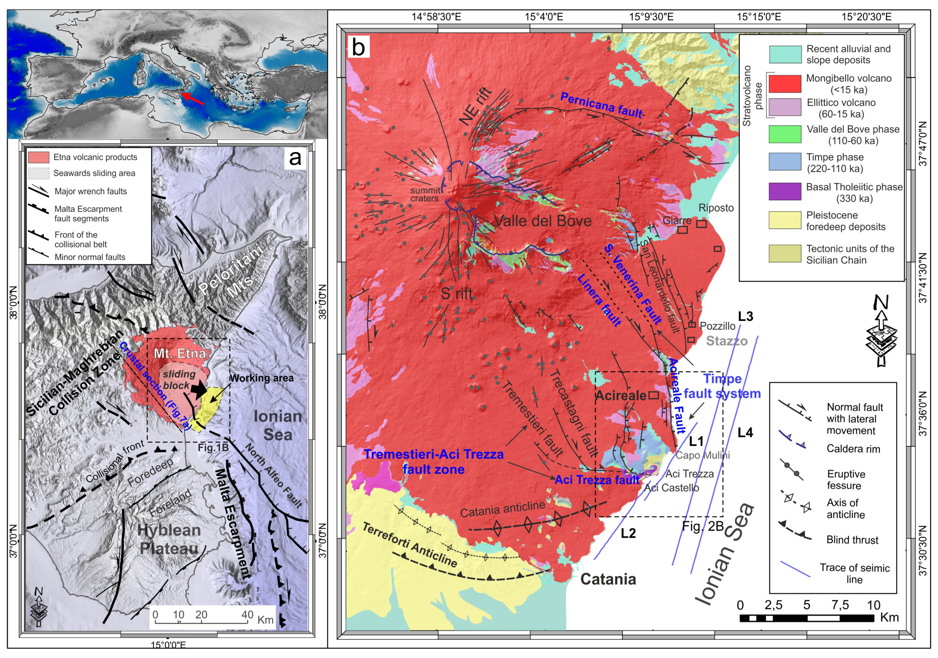
2. Regional Setting
2.1. Geodynamic Framework
2.2. Onland Sedimentary and Volcanic Stratigraphy
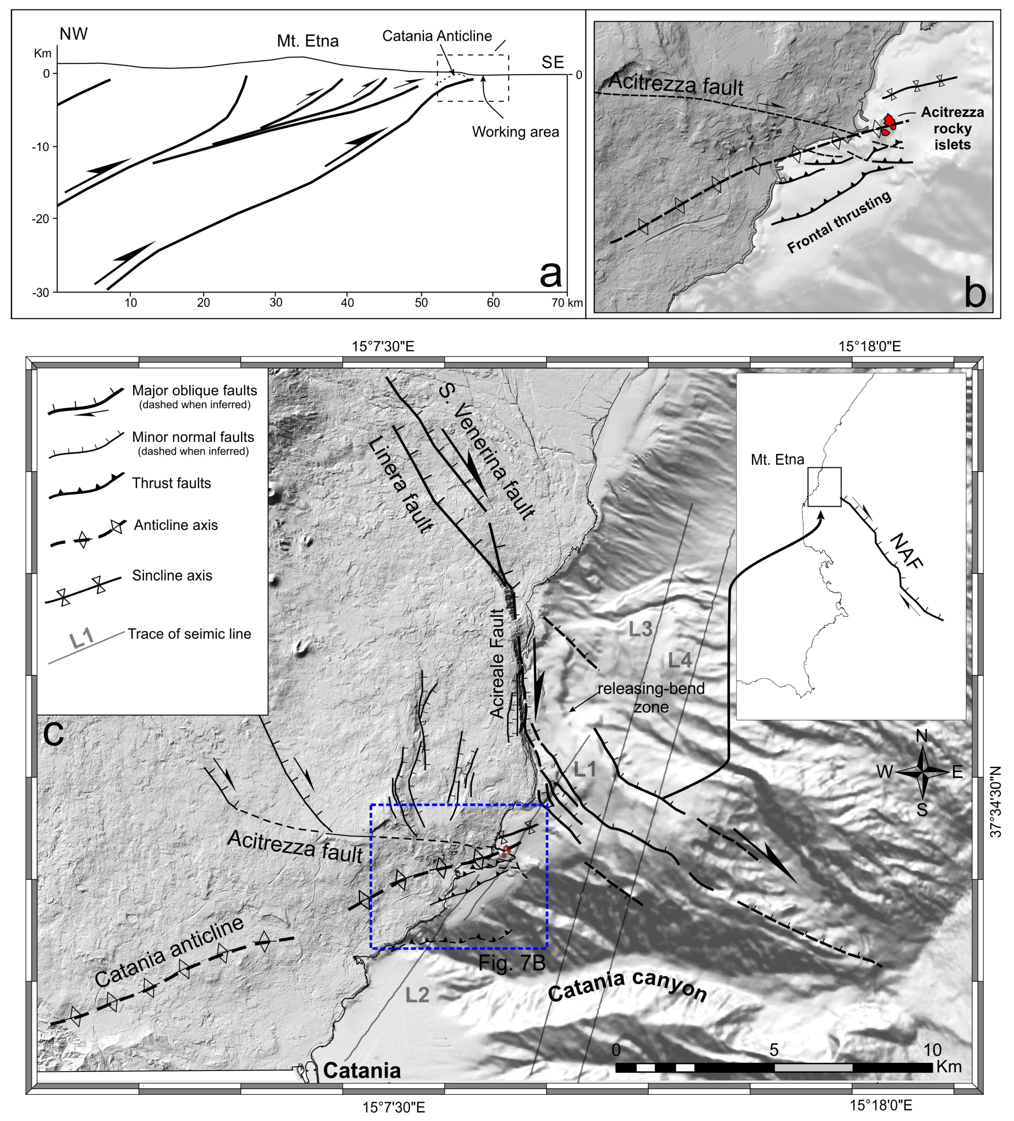
2.3. Active Tectonics in South-Eastern Sector of Mt. Etna
3. Materials and Methods
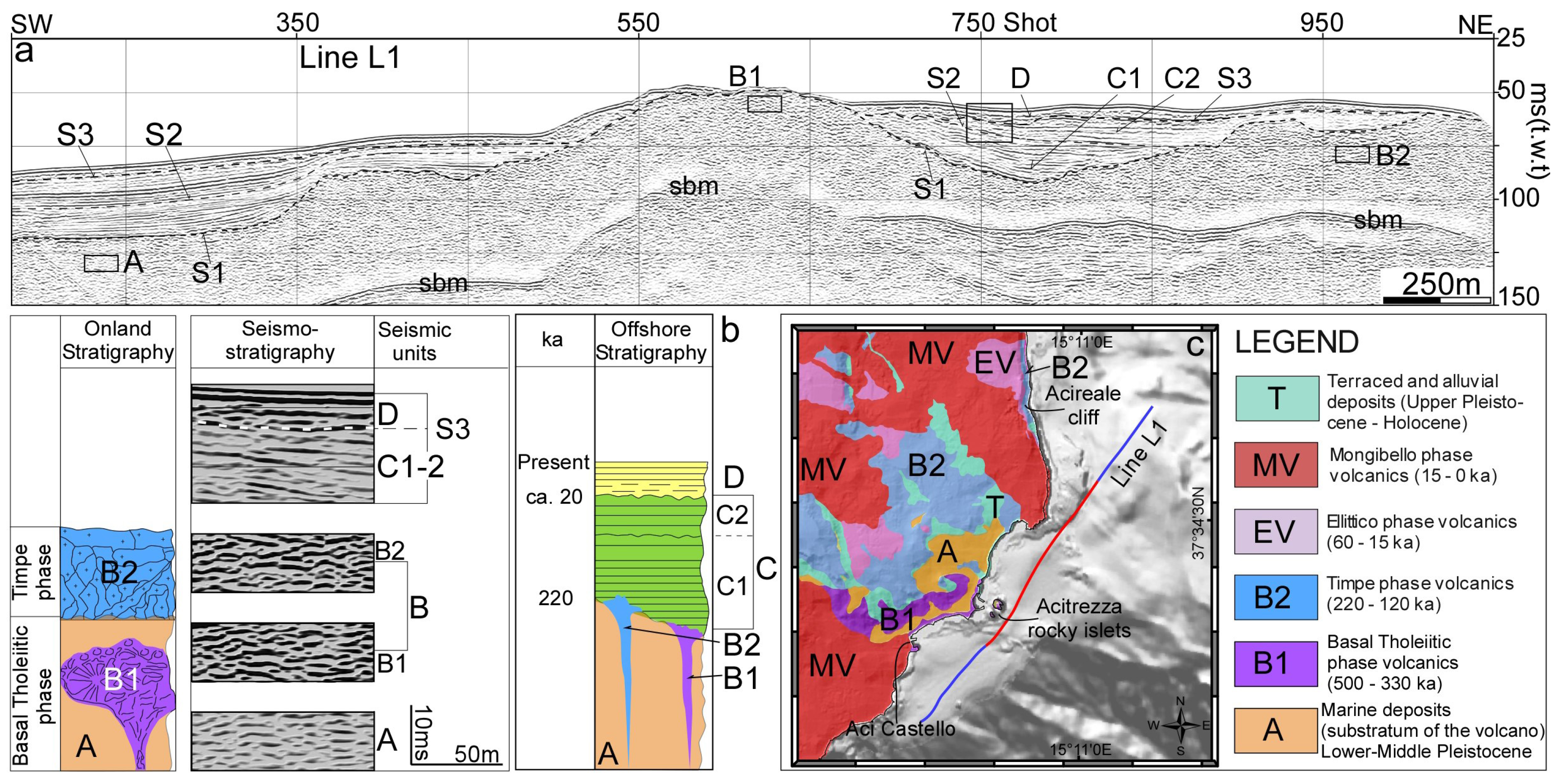
4. Results and Interpretations
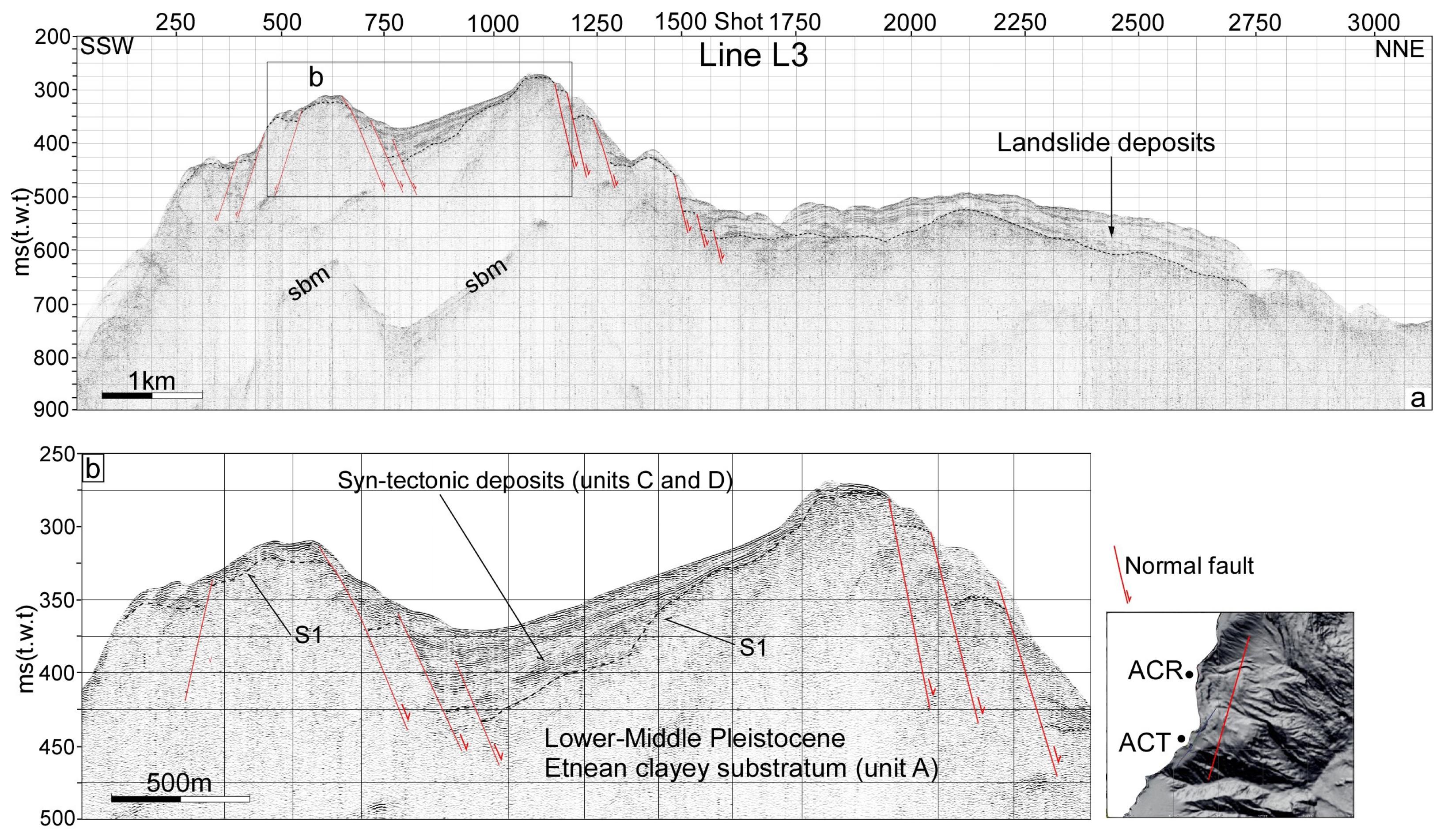
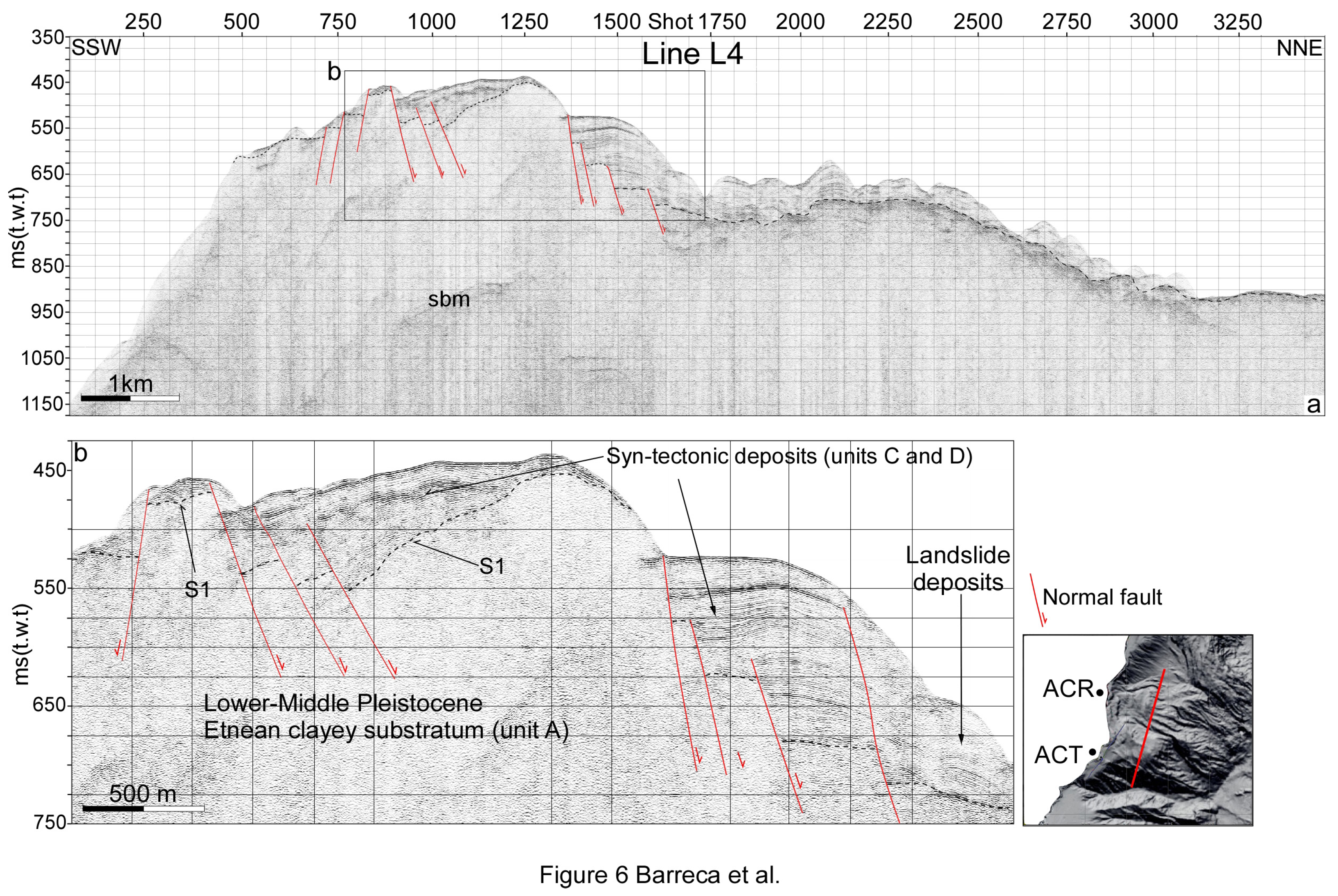
4.1. Seismic Stratigraphy
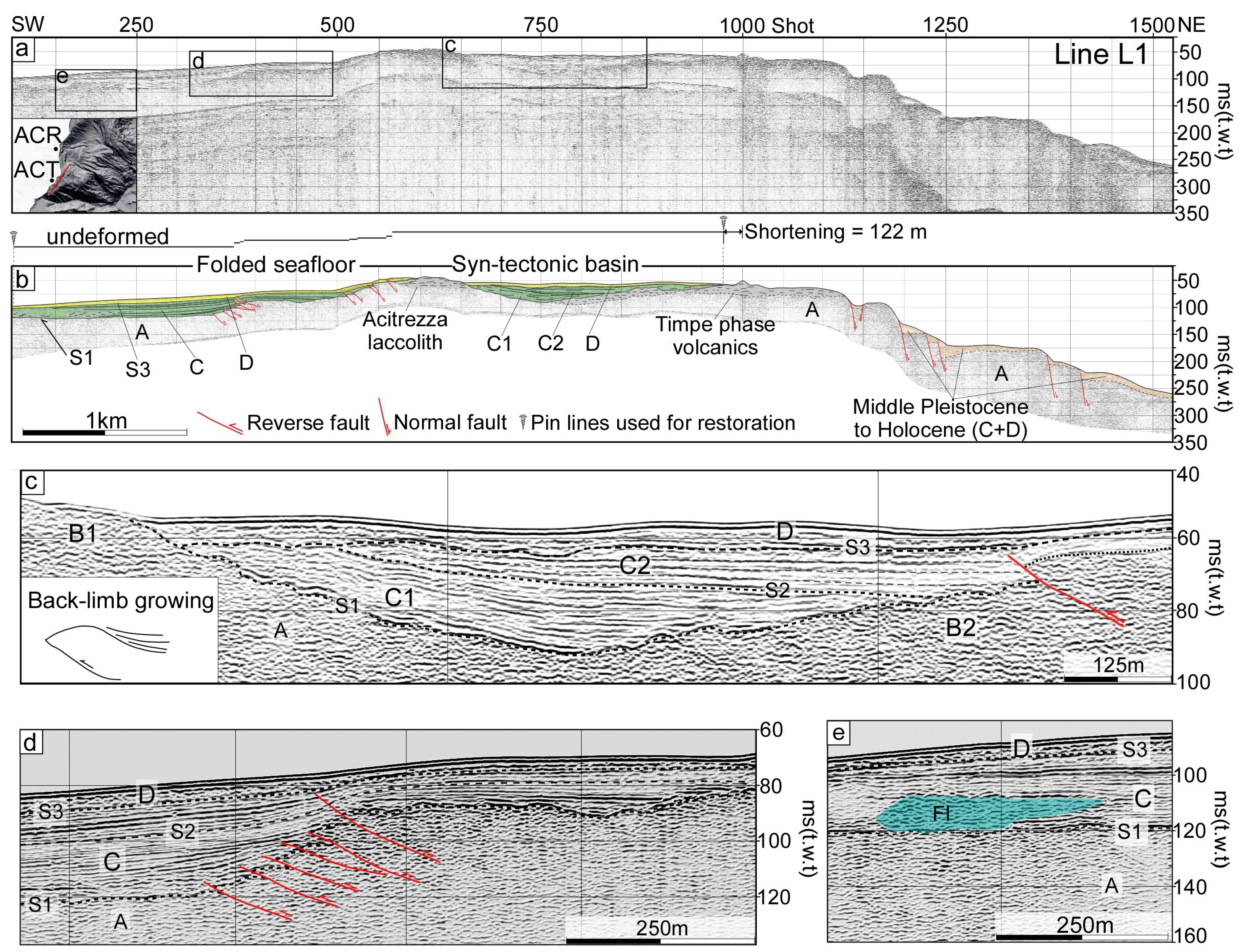
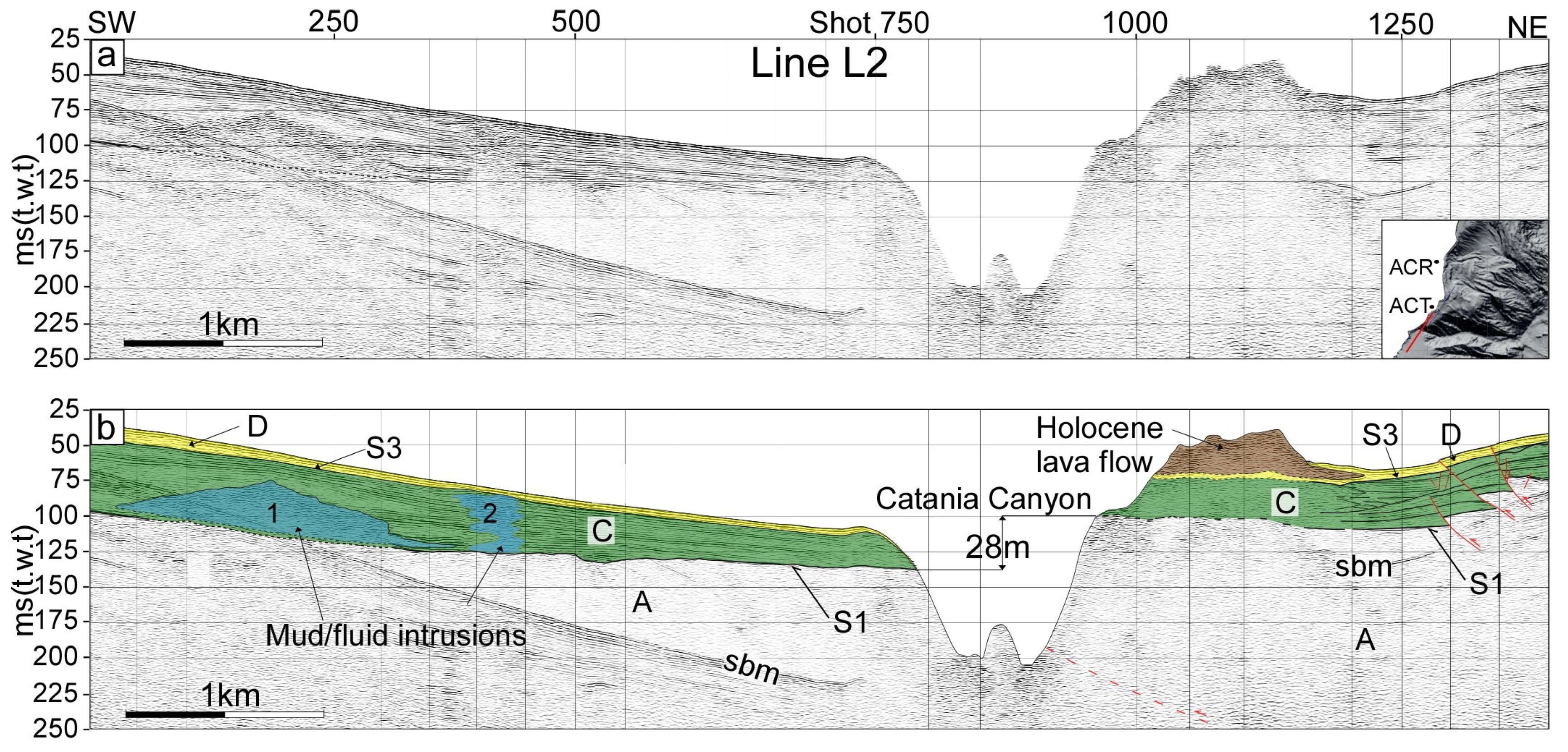
4.2. Depositional Architecture of Seismic-Stratigraphic Units
4.3. Deformation Pattern
5. Discussion
6. Conclusions
- the occurrence of contractional and extensional structures active since the Middle Pleistocene suggests that the deformation of the SE offshore margin of Mt. Etna must be related not only to gravity sliding, as previously stated but also to regional-scale tectonic processes;
- the Aci Trezza offshore area has experienced continuous shortening from the Middle Pleistocene to Present. The long-term rate of convergence was estimated in ~0.5 mm/yr in the last 220 ka, which is consistent with geodetic regional shortening measured along the front of the Sicilian chain. WNW-ESE trending contractional structures are interpreted as frontal splays of active detachment folds, aseismically growing in the northern outskirt of Catania;
- active extensional faults occur NE of the contractional structures; these correspond to the seaward prolongation of the NW-SE trending transtensional Timpe Fault System and has favoured fluids intrusions;
- seismic profiles and bathymetric map coherently indicate that the NW-SE trending extensional fault system turn to N-S direction near the Ionian coastline and it connects with the Timpe Fault System on-land, forming, as a whole, a releasing-bend zone;
- our data highlight that active contractional and extensional tectonic processes coexist in the south-eastern sector of Mt. Etna and prevail over flank sliding processes; thrust and folding can be related to the late migration of the Sicilian thrust-belt front, whereas oblique faulting to the east is probably part of the major kinematic boundary located in the western Ionian Sea.
Acknowledgments
Author Contributions
Conflicts of Interest
References
- Palano, M.; Ferranti, L.; Monaco, C.; Mattia, M.; Aloisi, M.; Bruno, V.; Cannavò, F.; Siligato, G. GPS velocity and strain fields in Sicily and southern Calabria, Italy: Updated geodetic constraints on tectonic block interaction in the central Mediterranean. J. Geophys. Res. 2012, 117, B07401. [Google Scholar] [CrossRef]
- Branca, S.; Coltelli, M.; De Beni, E.; Wijbrans, J. Geological evolution of Mount Etna volcano (Italy) from earliest products until the first central volcanism (between 500 and 100 ka ago) inferred from geochronological and stratigraphic data. Int. J. Earth Sci. 2007, 97, 135–152. [Google Scholar] [CrossRef]
- Azzaro, R.; Bonforte, A.; Branca, S.; Guglielmino, F. Geometry and kinematics of the fault systems controlling the unstable flank of Etna volcano (Sicily). J. Volcan. Geother. Res. 2013, 251, 5–15. [Google Scholar] [CrossRef]
- Rasà, R.; Azzaro, R.; Leonardi, O. Aseismic creep on faults and flank instability at Mt. Etna Volcano, Sicily. In Volcano Instability on the Earth and Other Planets; McGuire, W.C., Jones, A.P., Neuberg, J., Eds.; Special Publications; Geological Society: London, UK, 1996; Volume 110, pp. 179–192. [Google Scholar]
- Rust, D.; Neri, M. The boundaries of large-scale collapse on the flanks of Mount Etna, Sicily. In Volcano Instability on the Earth and Other Planets; McGuire, W.C., Jones, A.P., Neuberg, J., Eds.; Special Publications; Geological Society: London, UK, 1996; Volume 110, pp. 193–208. [Google Scholar]
- Puglisi, G.; Bonforte, A. Dynamics of Mount Etna volcano inferred from static and kinematic GPS measurements. J. Geophys. Res. 2004, 109, B11404. [Google Scholar] [CrossRef]
- Bonforte, A.; Puglisi, G. Dynamics of the eastern flank of Mount Etna volcano (Italy) investigated by a dense GPS network. J. Volcanol. Geotherm. Res. 2006, 153, 357–369. [Google Scholar] [CrossRef]
- Froger, J.L.; Merle, O.; Briole, P. Active spreading and regional extension at Mount Etna imaged by SAR interferometry. Earth Planet. Sci. Lett. 2001, 148, 245–258. [Google Scholar] [CrossRef]
- Lundgren, P.; Casu, F.; Manzo, M.; Pepe, A.; Berardino, P.; Sansosti, E.; Lanari, R. Gravity and magma induced spreading of Mount Etna volcano revealed by satellite radar interferometry. Geophys. Res. Lett. 2004, 31. [Google Scholar] [CrossRef]
- Bonforte, A.; Guglielmino, F.; Coltelli, M.; Ferretti, A.; Puglisi, G. Structural assessment of Mount Etna volcano from Permanent Scatterers analysis. Geochem. Geophys. Geosyst. 2011, 12. [Google Scholar] [CrossRef]
- Chiocci, L.F.; Coltelli, M.; Bosman, A.; Cavallaro, D. Continental margin large-scale instability controlling the flank sliding of Etna volcano. Earth Planet. Sci. Lett. 2011, 305, 57–64. [Google Scholar] [CrossRef]
- Gross, F.; Krastel, S.; Geersen, J.; Hinrich, B.J.; Ridente, D.; Chiocci, F.L.; Bialas, J.; Papenberg, C.; Cukur, D.; Urlaub, M.; et al. The limits of seaward spreading and slope instability at the continental margin offshore Mt Etna, imaged by high-resolution 2D seismic data. Tectonophysics 2016, 667, 63–76. [Google Scholar] [CrossRef] [Green Version]
- Gutscher, M.; Dominguez, S.; Mercier de Lepinay, B.; Pinheiro, L.; Gallais, F.; Babonneau, N.; Cattaneo, A.; Le Faou, Y.; Barreca, G.; Micallef, A.; et al. Tectonic expression of an active slab tear from high-resolution seismic and bathymetric data offshore Sicily (Ionian Sea). Tectonics 2015, 34. [Google Scholar] [CrossRef]
- Polonia, A.; Torelli, L.; Artoni, A.; Carlini, M.; Faccenna, C.; Ferranti, L.; Gasperini, L.; Govers, R.; Klaeschen, D.; Monaco, C.; et al. The Ionian and Alfeo-Etna fault zones: New segments of an evolving plate boundary in the central Mediterranean Sea? Tectonophysics 2016, 675, 69–90. [Google Scholar] [CrossRef] [Green Version]
- Branca, S.; De Guidi, G.; Lanzafame, G.; Monaco, C. Holocene vertical deformation along the coastal sector of Mt. Etna volcano (eastern Sicily, Italy): Implications on the timespace constrains of the volcano lateral sliding. J. Geodyn. 2014, 82, 194–203. [Google Scholar] [CrossRef]
- Labaume, P.; Bousquet, J.C.; Lanzafame, G. Early deformations at a submarine compressive front: The Quaternary Catania foredeep south of Mt. Etna, Sicily, Italy. Tectonophysics 1990, 177, 349–366. [Google Scholar] [CrossRef]
- De Guidi, G.; Barberi, G.; Barreca, G.; Bruno, V.; Cultrera, F.; Grassi, S.; Imposa, S.; Mattia, M.; Monaco, C.; Scarfì, L.; et al. Geological, seismological and geodetic evidence of active thrusting and folding south of Mt. Etna (eastern Sicily): Revaluation of “seismic efficiency” of the Sicilian Basal Thrust. J. Geodyn. 2015, 90, 32–41. [Google Scholar] [CrossRef]
- Monaco, C.; Tapponnier, P.; Tortorici, L.; Gillot, P.Y. Late Quaternary slip rates on the Acireale-Piedimonte normal faults and tectonic origin of Mt. Etna (Sicily). Earth Planet. Sci. Lett. 1997, 147, 125–139. [Google Scholar] [CrossRef]
- Monaco, C.; De Guidi, G.; Ferlito, C. The Morphotectonic map of Mt. Etna. Ital. J. Geosci. 2010, 129, 408–428. [Google Scholar]
- Azzaro, R. Earthquake surface faulting at Mount Etna volcano (Sicily) and implications for active tectonics. J. Geodyn. 1999, 28, 193–213. [Google Scholar] [CrossRef]
- Mattia, M.; Bruno, V.; Caltabiano, T.; Cannata, A.; Cannavò, F.; D’Alessandro, W.; Di Grazia, G.; Federico, C.; Giammanco, S.; La Spina, A.; et al. A comprehensive interpretative model of slow slip events on Mt. Etna’s eastern flank. Geochem. Geophys. Geosyst. 2015, 16, 635–658. [Google Scholar] [CrossRef]
- Monaco, C. Tettonica pleistocenica nell’area a sud dell’Etna (Sicilia orientale). Ital. J. Quat. Sci. 1997, 10, 393–398. [Google Scholar]
- Lavecchia, G.; Ferrarini, F.; De Nardis, R.; Visini, F.; Barbano, M.S. Active thrusting as a possible seismogenic source in Sicily (Southern Italy): Some insights from integrated structural-kinematic and seismological data. Tectonophysics 2007, 445, 145–167. [Google Scholar] [CrossRef]
- Bousquet, J.C.; Lanzafame, G. The tectonics and geodynamic of Mt. Etna: Synthesis and interpretation of geological and geophysical data. In Mt. Etna: Volcano Laboratory; Bonaccorso, A., Calvari, S., Coltelli, M., Del Negro, C., Falsaperla, S., Eds.; American Geophysical Union: Washington, DC, USA, 2004; Volume 143, pp. 29–47. [Google Scholar]
- Lanzafame, G.; Bousquet, J.C. The Maltese escarpment and its extension from Mt. Etna to the Aeolian Islands (Sicily): Importance and evolution of a lithosphere discontinuity. Acta Vulcanol. 1997, 9, 113–120. [Google Scholar]
- Bianca, M.; Monaco, C.; Tortorici, L.; Cernobori, L. Quaternary normal faulting in southeastern Sicily (Italy): A seismic source for the 1693 large earthquake. Geophys. J. Int. 1999, 139, 370–394. [Google Scholar] [CrossRef]
- Argnani, A.; Bonazzi, C. Malta Escarpment fault zone offshore eastern Sicily: Pliocene-Quaternary tectonic evolution based on new multichannel seismic data. Tectonics 2005, 24. [Google Scholar] [CrossRef]
- Barreca, G.; Bruno, V.; Cultrera, F.; Mattia, M.; Monaco, C.; Scarfì, L. New insights in the geodynamics of the Lipari-Vulcano area (Aeolian Archipelago, southern Italy) from geological, geodetic and seismological data. J. Geodyn. 2014, 182, 150–167. [Google Scholar] [CrossRef]
- Hirn, A.; Nicolich, R.; Gallart, J.; Laigle, M.; Cernobori, L. Roots of Etna volcano in faults of great earthquakes. Earth Planet. Sci. Lett. 1997, 148, 171–191. [Google Scholar] [CrossRef]
- Gvirtzman, Z.; Nur, A. The formation of Mount Etna as the consequence of slab rollback. Nature 1999, 401, 782–785. [Google Scholar] [CrossRef]
- Doglioni, C.; Innocenti, F.; Mariotti, G. Why Mt Etna? Terra Nova 2001, 13, 25–31. [Google Scholar] [CrossRef]
- Polonia, A.; Torelli, L.; Gasperini, L.; Mussoni, P. Active faults and historical earthquakes in the Messina Straits area (Ionian Sea). Nat. Hazards Earth Syst. Sci. 2012, 12, 2311–2328. [Google Scholar] [CrossRef] [Green Version]
- Polonia, A.; Torelli, L.; Mussoni, P.; Gasperini, L.; Artoni, A.; Klaeschen, D. The Calabrian Arc subduction complex in the Ionian Sea: Regional architecture, active deformation, and seismic hazard. Tectonics 2011, 30. [Google Scholar] [CrossRef] [Green Version]
- Gallais, F.; Gutscher, M.A.; Klaeschen, D.; Graindorge, D. Two-stage growth of the Calabrian accretionary wedge in the Ionian Sea (Central Mediterranean): Constraints from depth-migrated multichannel seismic data. Mar. Geol. 2012, 326–328, 28–45. [Google Scholar] [CrossRef]
- Di Stefano, A.; Branca, S. Long-term uplift rate of the Etna volcano basement (southern Italy) based on biochronological data from Pleistocene sediments. Terra Nova 2001, 14, 61–68. [Google Scholar] [CrossRef]
- Kieffer, G. Dépots et niveaux marins et fluviatiles dé la regione de Catane (Sicile). Méditerranée 1971, 5–6, 591–626. [Google Scholar] [CrossRef]
- Ristuccia, G.M.; Di Stefano, A.; Gueli, A.M.; Monaco, C.; Stella, G.; Troja, S.O. OSL chronology of Quaternary terraced deposits outcropping between Mt. Etna volcano and the Catania Plain (Sicily, southern Italy). Phys. Chem. Earth 2013, 63, 36–46. [Google Scholar] [CrossRef]
- De Beni, E.; Branca, S.; Coltelli, M.; Groppelli, G.; Wijbrans, J. 39Ar/40Ar isotopic dating of Etna volcanic succession. Ital. J. Geosci. 2011, 130, 292–305. [Google Scholar] [CrossRef]
- Corsaro, RA.; Neri, M.; Pompilio, M. Paleo-environmental and volcano-tectonic evolution of the southeastern flank of Mt. Etna during the last 225 ka inferred from the volcanic succession of the ‘‘Timpe’’, Acireale, Sicily. J. Volcanol. Geotherm. Res. 2001, 113, 289–306. [Google Scholar] [CrossRef]
- Azzaro, R.; Branca, S.; Gwinner, K.; Coltelli, M. The volcano-tectonic map of Etna volcano, 1:100.000 scale: An integrated approach based on a morphotectonic analysis from high-resolution DEM constrained by geologic, active faulting and seismotectonic data. Ital. J. Geosci. 2012, 131, 153–170. [Google Scholar] [CrossRef]
- Azzaro, R.; Barbano, M.S.; Antichi, B.; Rigano, R. Macroseismic catalogue of Mt. Etna earthquakes from 1832 to 1998. Acta Vulcanol. 2000, 12, 3–36. [Google Scholar]
- Monaco, C.; Catalano, S.; Cocina, O.; De Guidi, G.; Ferlito, C.; Gresta, S.; Musumeci, C.; Tortorici, L. Tectonic control on the eruptive dynamics at Mt. Etna volcano (eastern Sicily during the 2001 and 2002–2003 eruptions. J. Volcanol. Geotherm. Res. 2005, 144, 221–233. [Google Scholar] [CrossRef]
- Alparone, S.; D’Amico, S.; Gambino, S.; Maiolino, V. Buried active faults in the Zafferana Etnea territory (south-eastern flank of Mt. Etna): Geometry and kinematics by earthquake relocation and focal mechanisms. Ann. Geophys. 2013, 56. [Google Scholar] [CrossRef]
- Firth, C.; Stewart, I.; McGuire, W.M.; Kershaw, S.; Vita-Finzi, C. Coastal elevation changes in eastern Sicily: Implications for volcano instability at Mount Etna. In Volcano Instability on the Earth and Other Planets; McGuire, W.C., Jones, A.P., Neuberg, J., Eds.; Special Publications; Geological Society: London, UK, 1996; Volume 110, pp. 153–167. [Google Scholar]
- Stewart, I.; Cundy, A.; Kershaw, S.; Firth, C. Holocene coastal uplift in the Taormina area, northeastern Sicily: Implications for the southern prolongation of the Calabrian seismogenic belt. J. Geodyn. 1997, 24, 37–50. [Google Scholar] [CrossRef]
- Antonioli, F.; Kershaw, S.; Rust, R.; Verrubbi, V. Holocene sea-level change in Sicily and its implications for tectonic models: New data from the Taormina area, northeast Sicily. Mar. Geol. 2003, 196, 53–71. [Google Scholar] [CrossRef]
- Antonioli, F.; Ferranti, L.; Lambeck, K.; Kershaw, S.; Verrubbi, V.; Dai Pra, G. Late Pleistocene to Holocene record of changing uplift rates in southern Calabria and northeastern Sicily (southern Italy, Central Mediterranean Sea). Tectonophysics 2006, 422, 23–40. [Google Scholar] [CrossRef]
- Branca, S. Geological and geomorphologic evolution of the Etna volcano NE flank and relationships between lava flow invasions and erosional processes in the Alcantara Valley (Italy). Geomorphology 2003, 53, 247–261. [Google Scholar] [CrossRef]
- Spampinato, C.R.; Scicchitano, G.; Ferranti, L.; Monaco, C. Raised Holocene paleo-shorelines along the Capo Schisò coast, Taormina: New evidence of recent co-seismic deformation in northeastern Sicily (Italy). J. Geodyn. 2012, 55, 18–31. [Google Scholar] [CrossRef]
- Acocella, V.; Puglisi, G.; Amelung, F. Flank instability at Mt. Etna Preface. J. Volcanol. Geotherm. Res. 2013, 251, 1–4. [Google Scholar] [CrossRef]
- Argnani, A.; Mazzarini, F.; Bonazzi, C.; Bisson, M.; Isola, I. The deformation offshore of Mount Etna as imaged by multichannel seismic reflection profiles. J. Volcanol. Geotherm. Res. 2013, 251, 50–64. [Google Scholar] [CrossRef]
- Tibaldi, A.; Groppelli, G. Volcano-tectonic activity along structures of the unstable NE flank of Mt. Etna (Italy) and their possible origin. J. Volcanol. Geotherm. Res. 2002, 115, 277–302. [Google Scholar] [CrossRef]
- Ferranti, L.; Burrato, P.; Pepe, F.; Santoro, E.; Mazzella, M.E.; Morelli, D.; Passaro, S.; Vannucci, G. An active oblique-contractional belt at the transition between the Southern Apennines and Calabrian Arc: The Amendolara ridge, Ionian Sea, Italy. Tectonics 2014, 33, 2169–2194. [Google Scholar] [CrossRef]
- Loreto, M.F.; Pepe, F.; De Ritis, R.; Ventura, G.; Ferrante, V.; Speranza, F.; Tomini, I.; Sacchi, M. Geophysical investigation of Pleistocene volcanism and tectonics offshore Capo Vaticano (Calabria, southeastern Tyrrhenian sea). J. Geodyn. 2015, 90, 71–86. [Google Scholar] [CrossRef]
- Damuth, J.E. Use of high-frequency (3.5–12 kHz) echograms in the study of near-bottom sedimentation processes in the deep-sea: A review. Mar. Geol. 1980, 38, 51–75. [Google Scholar] [CrossRef]
- Lambeck, K.; Antonioli, F.; Anzidei, M.; Ferranti, L.; Leoni, G.; Scicchitano, G.; Silenzi, S. Sea level change along the Italian Coast during the Holocene projections for the future. Quat. Int. 2011, 232, 250–257. [Google Scholar] [CrossRef]
- Spratt, R.M.; Lisiecki, L.E. A Late Pleistocene sea level stack. Clim. Past 2016, 12, 1079–1092. [Google Scholar] [CrossRef]
- Clark, P.U.; Dyke, A.S.; Shakun, J.D.; Carlson, A.E.; Clark, J.; Wohlfarth, B.; Mitrovica, J.X.; Hostetler, S.W.; McCabe, A.M. The Last Glacial Maximum. Science 2009, 325, 710–714. [Google Scholar] [CrossRef] [PubMed]
- Oba, T.; Irino, T. Sea level at the last glacial maximum, constrained by oxygen isotopic curves of planktonic foraminifera in the Japan Sea. J. Quat. Sci. 2012, 27, 941–947. [Google Scholar] [CrossRef]
- Cacho, I.; Grimallt, J.O.; Pelejerlo, C.; Canals, M.; Sierro, F.J.; Flores, J.A.; Shackleton, N. Dansgaard-Oeschger and Heinrich event imprints in Alboran Sea paleotemperatures. Paleoceanography 1999, 14, 698–705. [Google Scholar] [CrossRef]
- Somoza, L.; Medialdea, T.; León, R.; Ercilla, G.; Vázquez, J.T.; Farran, M.; Hernández-Molina, J.; González, J.; Juan, C.; Fernández-Puga, M.C. Structure of mud volcano systems and pockmarks in the region of the Ceuta Contourite Depositional System (Western Alborán Sea). Mar. Geol. 2012, 332–334, 4–26. [Google Scholar] [CrossRef]
- Torelli, L.; Grasso, M.; Mazzoldi, G.; Peis, D. Plio-Quaternary tectonic evolution and structure of the Catania foredeep, the northern Hyblean Plateau and the Ionian shelf (SE Sicily). Tectonophysics 1998, 298, 209–221. [Google Scholar] [CrossRef]
- Mattia, M.; Bruno, V.; Cannavò, F.; Palano, M. Evidences of a contractional pattern along the northern rim of the Hyblean Plateau (Sicily, Italy) from GPS data. Geol. Acta 2012, 10, 1–9. [Google Scholar]
- Cavallaro, D.; Bosman, A.; Chiocci, F.; Coltelli, M. A new morphobathymetric analysis of the submarine features in the neighbourhood of Acitrezza, Catania (Italy). In Proceedings of the Abstract Book of Meeting “Tethys to Mediterranean, a Journey of Geological Discovery”, Catania, Italy, 3–5 June 2008; p. 36. [Google Scholar]
- Monaco, C.; Petronio, L.; Romanelli, M. Tettonica estensionale nel settore orientale del Monte Etna (Sicilia): DATI morfotettonici e sismici. In Proceedings of the Atti del Convegno Geodinamica e Tettonica Attiva del Sistema Tirreno-Appennino, Camerino, Italy, 9–10 February 1995; pp. 363–374. [Google Scholar]


© 2018 by the authors. Licensee MDPI, Basel, Switzerland. This article is an open access article distributed under the terms and conditions of the Creative Commons Attribution (CC BY) license (http://creativecommons.org/licenses/by/4.0/).
Share and Cite
Barreca, G.; Corradino, M.; Monaco, C.; Pepe, F. Active Tectonics along the South East Offshore Margin of Mt. Etna: New Insights from High-Resolution Seismic Profiles. Geosciences 2018, 8, 62. https://doi.org/10.3390/geosciences8020062
Barreca G, Corradino M, Monaco C, Pepe F. Active Tectonics along the South East Offshore Margin of Mt. Etna: New Insights from High-Resolution Seismic Profiles. Geosciences. 2018; 8(2):62. https://doi.org/10.3390/geosciences8020062
Chicago/Turabian StyleBarreca, Giovanni, Marta Corradino, Carmelo Monaco, and Fabrizio Pepe. 2018. "Active Tectonics along the South East Offshore Margin of Mt. Etna: New Insights from High-Resolution Seismic Profiles" Geosciences 8, no. 2: 62. https://doi.org/10.3390/geosciences8020062
APA StyleBarreca, G., Corradino, M., Monaco, C., & Pepe, F. (2018). Active Tectonics along the South East Offshore Margin of Mt. Etna: New Insights from High-Resolution Seismic Profiles. Geosciences, 8(2), 62. https://doi.org/10.3390/geosciences8020062