Article

Matrix of Priorities for the Management of Visitation Impacts on the Geosites of Araripe UNESCO Global Geopark (NE Brazil)

by
Eduardo S. Guimarães
1,*,
Artur Sá
2,
Ronaldo Gabriel
3,
Helena Moreira
4,
Jaqueliny R. S. Guimarães
5,
Paulo Felipe R. Bandeira
6,
João Marcos F. de Lima Silva
7,
Rafael C. Soares
8 and
José Patrício P. Melo
9
1
Department of Sport Sciences, Exercise and Health, University of Trás-os-Montes e Alto Douro, UNESCO Chair on “Geoparks, Sustainable Regional Development and Healthy Lifestyles”, Quinta de Prados, 5000-801 Vila Real, Portugal
2
Department of Geology of the University of Trás-os-Montes e Alto Douro, Geosciences Centre of the University of Coimbra and UNESCO Chair on “Geoparks, Sustainable Regional Development and Healthy Lifestyles”, Quinta de Prados, 5000-801 Vila Real, Portugal
3
Department of Sport Sciences, Exercise and Health, Centre for Research and Technology of Agro-Environmental and Biological Sciences (CITAB), University of Trás-os-Montes e Alto Douro, UNESCO Chair on “Geoparks, Sustainable Regional Development and Healthy Lifestyles”, Quinta de Prados, 5000-801 Vila Real, Portugal
4
Department of Sport Sciences, Exercise and Health, Health and Human Development (CIDESD), CITAB, University of Trás-os-Montes e Alto Douro, UNESCO Chair on “Geoparks, Sustainable Regional Development and Healthy Lifestyles”, Quinta de Prados, 5000-801 Vila Real, Portugal
5
Department of Nurse, Regional University of Cariri, Street Cel. Antônio Luiz 1161, Pimenta, 63105-000 Crato-CE, Brazil
6
Department of Physical Education, Regional University of Cariri, Street Cel. Antônio Luiz 1161, Pimenta, 63105-000 Crato-CE, Brazil
7
Department of Physical Education, University Center Doctor Leão Sampaio; Leão Sampaio km 3, Lagoa Seca, 63180-000 Juazeiro do Norte/CE, Brazil
8
Department Geology, Post Graduation Program, Federal University of Ceará; Humberto Monte, s/n, Pici, 60440-593 Fortaleza/CE, Brazil
9
Department of Law, Rector of the Cariri Regional University, Coronel Antônio Luíz, 1161, Pimenta, 63105-000 Crato/CE, Brazil
*
Author to whom correspondence should be addressed.
Geosciences 2018, 8(6), 199; https://doi.org/10.3390/geosciences8060199
Submission received: 22 May 2018 / Revised: 29 May 2018 / Accepted: 29 May 2018 / Published: 1 June 2018
(This article belongs to the Special Issue Selected Papers from the “14th European Geoparks Conference”)

Abstract

:
In order to safeguard the material and immaterial heritage and to foster delightful experiences for visitors, this investigation aimed to define a Matrix of Priorities for management of Visitation Impacts Management on the Geosites of Araripe UNESCO Global Geopark. With a quantitative approach involving the revision of documents, the methods used in this paper determined what the demands for visitation are as well as the impacts of these demands. We identified the offers for activities and occurrences in the geosites. Using this model, we calculated the following variables: (i) evident impacts, (ii) management profile, (iii) visitor demand and (iv) activity zone. We also classified the recommended management actions and presented the priority matrix. We classified the geosites of Ponte de Pedra, Riacho do Meio and Cachoeira de Missão Velha as requiring immediate or priority management action, in view of the high impacts of visitation evidenced. The geosites of Pedra Cariri, Floresta Petrificada and Parque dos Pterossauros were classified as programmed action, highlighting the difficulty of accessing them and the low demand for visitation. The geosites Pontal de Santa Cruz, Colina do Horto and Batateiras presented the best scores and require feedback action. It is emphasized that the deepening the investigations is required in order to produce and interpret the data complexity that guides the management of a dynamic territory such as a UNESCO Global Geopark.

1. Introduction

In the 20th century, relevant conceptual frameworks sensitized global organizations, political leaders, and the scientific community in regard to the reflection and discussion of the anthropocentric relationship between humans and nature and its resources. Thus, as proposed in “The Tragedy of the Commons”, the emerging need for the development of evaluation, management and environmental planning studies of public areas was emphasized in order to regulate the use of ecosystem resources and to prevent the capacity of the environment to regenerate being exceeded [1,2,3].
In this context, the Impact Management Plan is a technical document elaborated from the initial planning to the protected areas, conservation units (UCs), environmental reserves, natural parks and related areas, to zone, normalize, regulate and control areas of interest, with the purpose of equipping technicians and managers about the recognition process in order to prioritize, program and optimize decision-making, considering the limitations of available resources and personnel [4,5].
Even with the development and offering of different impact management methodologies, many ecosystems and their services have still suffered significant losses. In the European Union, about 30% of the whole territory has degraded, and the maintenance and recovery of this area is one of the objectives of the Environmental Action Program of 2020 [6].
In Brazil, the reality is even more worrying; despite the implementation of initiatives over the last decade, just over half of the 320 UCs have developed management plans [7,8]. In the existing protected areas, operationalization is limited, due to the shortage of technical personnel, budgetary deficiencies and few successful experiences in the operationalization of management, thus configuring relatively poor conditions of visitation for UCs [9,10].

1.1. UNESCO Global Geoparks—The New Territories of the 21st Century

Since the 1970s, the United Nations Educational, Scientific and Cultural Organization (UNESCO), in its mission to promote the valorization and conservation of nature, has created programs and initiatives for collaboration among its member states. Among them, we highlight the Man and Biosphere and the World Heritage programs. More recently, in 2015 the International Geoscience and Geoparks Programme (IGGP) was approved, which includes the UNESCO Global Geoparks (UGGp) [11,12,13,14]. These programs have conceptual similarities but with unique approaches and strategies. The main convergence observed among programs is the representative, responsible and holistic concept of the mankind’s performance on the planet given its relevant transformative potential.
The UGGp is strongly influenced by its “older siblings” [13,15], yet it still imprints its own identity. Since its foundation in 2004 by the initiative of the Global Geoparks Network (GGN), it has put emphasis on the protection of geodiversity. The current Global Geopark Network has 140 members in 38 countries [16], mostly concentrated in the European continent and China—the regions where the first geoparks appeared [17,18,19].
A UGGp is considered a territory of international relevance due to the singularities and geological relevance of the region [20,21,22], and the geodiversity and biodiversity of the ecosystem, given the biotic and abiotic representation where it is inserted [23,24,25,26,27]. Still in its territorial context, it must have well-defined limits and be sufficient in size to support and contribute to the development of a region where landscapes and sites of proven scientific relevance, rarity, scenic beauty, and geological events and records coexist [28,29].
Nevertheless, the entire geological potential of the territory does not guarantee the UNESCO seal. It must essentially demonstrate the extent to which its diversity and its material and immaterial cultural heritage actually foster sustainable regional development based on the appreciation of traditional communities and their social, ethnic and cultural elements and manifestations which are interactive and inseparable and give them the unique characteristics of the site in which they are inserted. In this sense, it is understood that without the presence and active permanence of people in a territory a UGGp cannot be recognized [30,31].
The UGGp presents itself as an innovative proposal for territorial management and sustainable regional development, emphasizing the promotion of geotourism in the context of valuing and preserving the landscape as a destination and with the perspective of having social empowerment from the feeling of pride of local belonging [14,30,31,32,33]. Recently, studies and official positions, such as the World Health Organization (WHO) [34], have emphasized the importance of active and healthy lifestyles with an approach to nature through a set of ecosystem offerings. This is related to the potential of territories for the practice of “green exercise” in different scenarios. In addition, powerful and fundamental public health strategies are correlated with environmental preservation [34,35,36,37,38,39,40,41,42,43,44].
The recent expansion of the IGGP was also marked by the creation of the Geopark Network of Latin America and the Caribbean (GeoLAC) in January 2018 in the city of El Chico in Mexico. This network is composed of four official members: Araripe UGGp (Brazil), Grutas Del Palacio UGGp (Uruguay), Comarca Minera UGGp and Mixteca Alta UGGp (Mexico). The creation of GeoLAC has the mission to foster and expand the number of territories in the region, in line with the other continental networks of geoparks that already exist [45,46].
In Brazil, since 2006, Araripe UGGp has been the only successful case and has satisfactorily undergone two re-evaluations (“green card”) [12,47,48].
The arguments about Araripe’s historical milestone and the UGGp are already enough to investigate its impact on the territory as a case study. Nevertheless, the latent concept of “regional development” is highlighted, which justifies and motivates the interest of this study in regard to the contribution and production of knowledge that supports the theme of worldwide importance. In addition, the relevance of the Araripe UGGp in Brazil is as an inducer of the various and potential “geopark initiatives” in the country that are having difficulty consolidating applications to become UGGps [12,47,49,50].

1.2. Categorization, Recognition and Management of Natural Areas in Brazil

Regarding the legal aspects of the elaboration of management plans and their official recognition in Brazil, the Ministry of the Environment established a set of official guidelines and procedures that comprise the National System of Conservation Units (SNUC). These guidelines segment the conservation units into 12 different categories and establish the prerogatives for the development of management plans [51]. However, the concept of UGGp (even as an initiative) does not appear in any of the available classifications and, in this sense, besides not recognizing these territories as regulated and protected areas [52], does not foresee the necessity for the elaboration of management plans. Nevertheless, although a UGGp is not officially classified by SNUC, its segmented areas (geosites), as in the case of Araripe UGGp, are partially allocated into conservation units [31]. In this logic, the application of conceptual methods for the production and interpretation of data is considered relevant in order to understand the dynamics of UGGp territories and actively collaborate the management of these areas.
In this framework, the elaboration and application of management plans is justified given their contribution to the development of multicentric methodologies that have not yet been widely disseminated in the recent UNESCO program and which aim to interpret the dynamics of the areas of interest and to plan management strategies, in order to safeguard tangible and intangible heritage and to enable visitation for contemporary and future generations [39,53,54,55].
The objective of this research is to define the Matrix of Priorities for Managing Impacts of Visitation on the Geosites of Araripe UGGp, as a fundamental component of a wider research project currently in development.

2. Materials and Methods

This was a descriptive and exploratory study with transversal cross-section and quantitative data approaches. The study’s location was the GGN territories and Araripe UGGp was used as a case study. The object of study was the Management of Visitation Impacts, to determine the impacts of the demand for visitation in the geosites of the Araripe UGGp territory.
As a research study [56], the data sources used in this investigation were the reports from the geoconservation and geotourism sectors produced during the period from 2016 and 2017, in addition the Strategic Plan and Multicentric Master Plan, which were provided by the administration of the Araripe UGGp in order to permit the development of this study.

2.1. Analytical Instruments
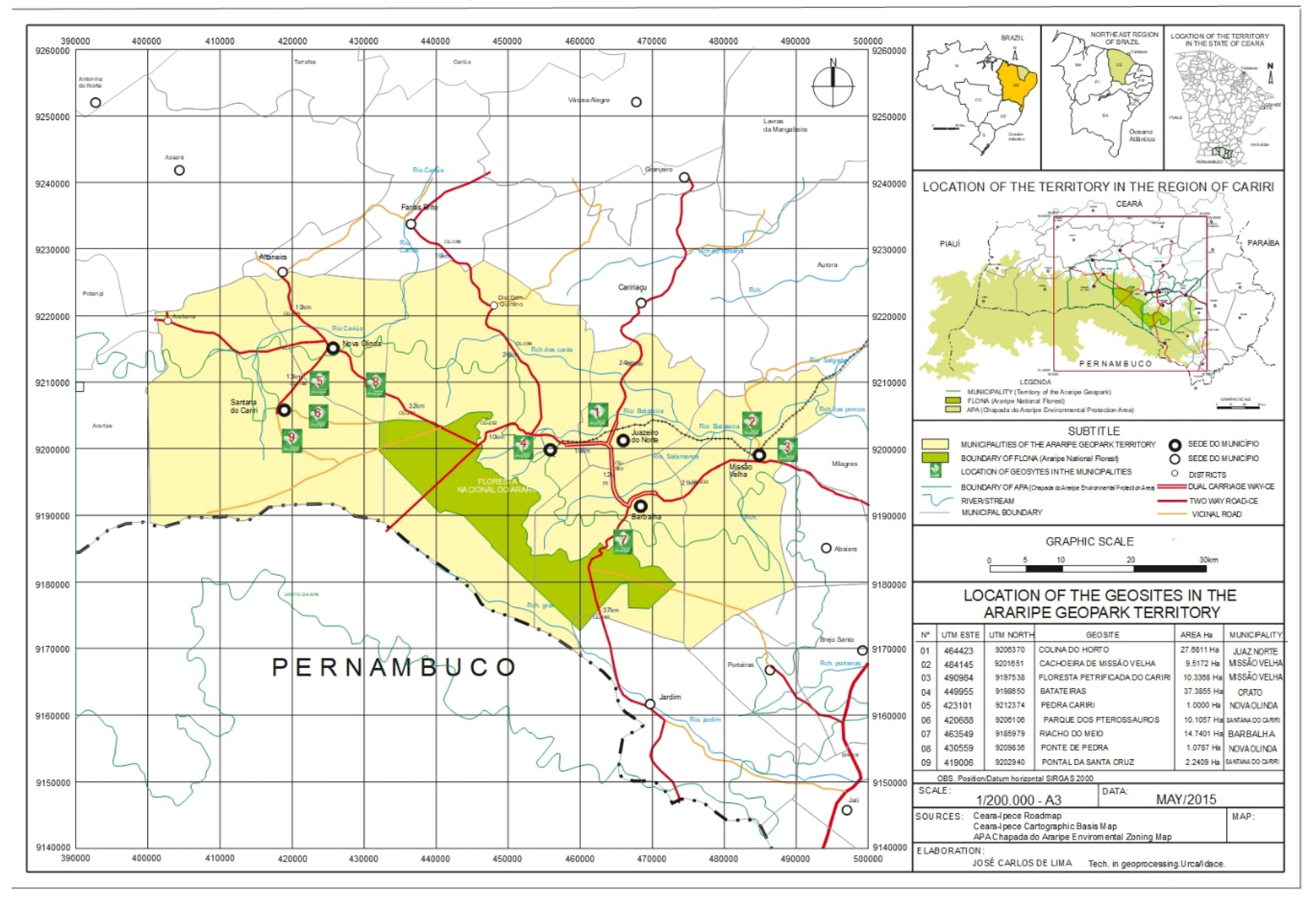
In this research we used the methodological script to determine the Impact Management of Visitation with a focus on visitor experience and on the protection of natural and cultural resources. This was originally created for application in the Brazilian UCs and has the main purpose of quantifying the impacts of the demands and behaviours of visitors in the areas of conservation of interest and qualifying the experiences of visitors [7].
The proposed and applied script in this study substantiated, agglutinated and referenced granted methodologies for the management of natural areas [7,57,58,59,60,61,62,63,64] and contributed to the proposal of a system to reduce the management cycle into five stages, thus optimizing the use of resources and personnel during the process [7]. Another relevant contribution was the delivery of a partial product at the end of each stage, allowing quick identification of problems, contributing to efficient management of the areas and equipment already in full operation. The methodology applied still showed effects of the subjectivity that are inherent to inventory methods that are related to geodiversity [28,65].
In addition to the use of the proposed and planned script as a guiding methodology, we followed the recommended guidelines for the “management environment” established in the Recreation Opportunity Spectrum (ROS) evaluation gradient (Spanish version ROVAP) [57,58], to guide the pragmatic observation of management as a correlative constraint in the interpretation of the characteristics of the territory.

2.2. Case Study

Araripe UGGp was the territory in which this research was carried out. This is located in the northeast of Brazil, in the south mesoregion of the State of Ceará, known as Cariri Cearense, about 500 km from Fortaleza, the state capital. The first UGGp of the Americas has an area of 3441 km2, distributed between six municipalities: Crato, Juazeiro do Norte, Barbalha, Missão Velha, Nova Olinda and Santana do Cariri, and there are nine geosites in its territory that are open to the public for visitation and are of relevant geological, paleontological, archaeological and historical value. Its location presents also a significant potential for “green exercise” practices [31,66] (see Figure 1).

2.3. Variable Calculations for Defining the Priority Matrix

The variables of impact, demand, zone and management were measured ordinally, staggered in three levels based on the commitment of the present conditions (higher values express greater commitment). These values were used to obtain a score in order to help to estimate the management priority of an area.
The application of the proposed formula in the original model for conservation units was adapted considering the nuances and unique features of a UGGp territory whose main determinant is the presence and active permanence of humans in the territory. In the original formula the variable impacts, demands and zones were considered. We also inserted a fourth variable called “management”, as a protection or exposure factor between impacts and demand for visitation [57,58,64].
It should also be emphasized that in the original formula of the method used, the variable “impact” was given a double weight [7]. However, we weighted using the components and documented occurrences that comprised the impact, and it was concluded that the presence of conditions that result in higher values expresses a scenario that should have greater discriminant power. In this sense, we decided to square the impact variable after its correction with the management variable, concluding that, in order to safeguard the ecosystem resources, the impact on the environment must take priority over the demand for visitation [67].
The reformulated mathematical model presented here was used to establish the centrality measures in order to classify the correlation pattern of the variables to elucidate and understand the dynamics in the areas of interest. It considers, in a correlated and active way, the performance of human beings as interveners in a territory, from the impacts coming from visitation to the performance of the management in the characteristics and conditions of the visitation zones. The following equation was used for the calculation of the variables:
M P = ( I + M 2 ) 2 + D + M 2 + Z ,
where, MP represents the management priority; I is the impact, D is the demand, M is the management and Z is the zone.
From this formula, it is possible to obtain values between 3 and 15 points; higher values imply higher intervention priority in the evaluated area. Four priority management classifications were established based on the cut-off values of the quartiles and are distributed in the quadrants in the flowchart in Figure 2 adapted from the demand-control model [68,69,70], where the following alphanumeric results were obtained (Table 1 and Table 2). The blue quadrant (A6) represents, “Feedback“(up to 6 points) and the green quadrant (B9) represents “Scheduled “(between 6.1 and 9 points); these are in the safe score area (safe). The yellow quadrant (C12) represents “Priority” (between 9.1 and 12 points) and the red quadrant (D5) represents “Immediate” (from 12.1 points); these are in the vulnerable scores area (not safe).

2.3.1. Impacts

The evident impacts on the geosites listed and described in the reports of the geoconservation sector, as inclusion criteria, are due to the presence and relationship of human beings with the environment and relate to occurrences that have become more noticeable and visible as a result of exploration and extrativism actions or derogatory and predatory behaviour of visitors, passers-by or adjacent communities to the geosites [7,62,71,72]. These impacts were classified by the prevalence of occurrences of environmental impact as a measure of frequency [62,73,74,75].

2.3.2. Demand

In order to define the demand for visitation as a variable, the data of visitors described in the reports of the geotourism sector were organized based on the official records and control of the Araripe UGGp technical staff, the Secretariats of Tourism in the municipalities, and the organized entities of the public and private sectors and the third sector as well as the records of the guides and visitation to the tourist area adjacent to the geosites [58,61]. The results of the data segment the geosites into three distinct categories given the intensity of the identified visitation.

2.3.3. Location Zones

The zone variable was focused on the quality of visitation experience. For this variable, the control and regulation of visitor access, the limitations of accessibility, the offers of service, and the products and support equipment available in the destination of interest were considered.
Therefore, we considered Zone 1 to be “ideal”. This included areas with free access or regulated by scheduling and/or control of the number of visitors. They offer services, products and support equipment to provide a satisfactory visitation experience with easy accessibility that is ideal for diverse audiences. Zone 2 is classified as “limited”. This includes areas with free or regulated access for visitation requiring scheduling, but accessibility is limited by geographical or structural characteristics and/or conditions. Support equipment may not exist or may not be fully operational, and offers of experience are directed to segmented groups with an interest in scientific, educational content, registration and contemplation of nature or to the practice of programmed physical activities. Zone 3 is classified as “weak”. This includes areas with free access to visitation. These areas are mainly for registration and contemplation of nature, with limited accessibility and no offers of service, products or support equipment. This is the zone with greatest vulnerability to impacts due to possible inappropriate behaviour of visitors [7,57,58].

2.3.4. Management

The management variable focuses on the control of visitation impacts, considering the control and/or regulation of visitor access, the presence of a tourist information desk, tourist guidance, and surveillance and regular patrolling [7,57,58].
The classifications used for this variable were Management 1, “active”, in which there is a permanent presence of staff in the area, presence of an information desk and/or conditioned or optional guidance, surveillance and/or regular patrolling. Management 2, “responsible” represents areas with no permanent presence of staff given the low or irregular demand for visitation and possible limitation of infrastructure or personnel. The presence of receptive and guidance is optional for visitation and occurs in scheduled and/or scheduled actions and the management performance is responsive to the occurrences reported by patrolling in the area. Management 3, “passive” represents areas where the performance of the management team is irregular and occurs due to possible occurrences reported. Patrolling is occasional, and the impacts tend to be more prevalent among areas in the territory [7,57,58,61].
For the four variables calculated, the score was based on an intensity scale from one to three points where the lowest overall score indicated the best classification result [7] (see Table 3).

3. Results and Discussion

The impacts recorded in the reports of the geoconservation sector were tabulated in order to identify their occurrences in the geosites. The classification in Table 4 shows the records of impacts and subsequently, lists the occurrences reported by geosite, obtaining a panorama of geosites that are more and less vulnerable to relative and absolute impacts in the territory.
It is noted that the characteristics of the evident impacts reported in Table 4, reflect the unique features and dynamics of the territory of Araripe UGGp. So, considering that each UGGp is sui generis, it is suggested that in other studies, both in UGGp and in other areas of interest, the tabulation of the occurrence of impacts follows the characteristics of the area evaluated, for example, indicators of physical, biological and social impacts [62]. This flexible impact recording strategy which does not segment the indicators and considers the prevalence as a frequency measure, is commonly used in epidemiological investigations [73,74,75]. It has been used to contribute to the holistic consideration of subjects that relate to the geosciences, and has previously been used in proposals of a related nature [28,65,66,67].
Among the results presented in Table 5, we highlight the evidence of impacts potentially resulting from the inadequate behaviour of visitors, due to the high prevalence of inappropriate disposal of garbage and residues [76] and evidence of graffiti and depredation of natural and projected structures. Given the nature of these occurrences, it is suggested to that environmental education and visitor sensitization must be emphasized concomitantly with patrolling and regulation strategies the area, in order to safeguard and preserve the territory with collaborative actions among the management institutions to revert the results presented.
It is worth mentioning that, according to the master plan of management of the Araripe UGGp, the local town hall is responsible for surveillance and patrolling of the geosites located in the municipality. The Araripe UGGp management structure is mainly responsible for fostering regional development and proposing guidelines to properly manage equipment, mobilizing technical staff to develop appraisals, reports and the production of guiding documents. The Araripe UGGp Master Plan directs the co-responsibility of the various entities while managing the area, but nevertheless emphasizes the intervention of the Araripe UGGp management structure to resolve the problems regarding the conditions of the geosites in its territory, including the commitment and feasibility of resources for this purpose.
As for the demand for visitation, the proportional distribution was based on the number of absolute visitors to the territory as well as by geosite, to determine the intensity of demand according to the scale adopted in Table 4 [7]. The visitation data were classified according to the geosite search, establishing two cut ranges and the three intensity references, thus defining high, medium and low levels of visitation demand, as seen in Figure 3.
It was observed that the geosites with high demand for visitation are those that offer the greatest diversity in attractions and experiences in their area or have a touristic element present in their environment. Among these, the Colina do Horto geosite stands out as a place of relevance in the national scenery, as a sanctuary and religious touristic destination [87]. On this geosite exists a statue and a museum dedicated to Priest Cícero Romão, a historic religious and political leader and a figure with great representation in the Northeastern popular culture, considered to be a Saint by his followers for having founded the city of Juazeiro do Norte [80,87].
Pontal de Santa Cruz is another highlighted geosite, on the top of the Araripe Plateau. It has a large number of visitors interconnected with the Museum of Paleontology “Plácido Cidade Nuvens”, of URCA, which receives about 40,000 visitors per year, as well as the city of Santana do Cariri, a recognized paleontological site of worldwide relevance [88,89,90].
In spite of its average demand for visitation and lack of supply of activities, the Ponte de Pedra geosite presents characteristics similar to those of high demand. The reason for this is the visitors’ contribution to other equipment in the city of Nova Olinda, where the Casa Grande Foundation is located, as well as its social role for the community and tourism [91].
The other geosites with average visitation demands showed an inversely proportional characteristics. In terms of positive aspects, the Batateiras geosite in Sítio Fundão State Park (Crato city) [92] stands out, with an increasing demand for visitation due to its forest route and environmental education program in a preserved circuit of trails. On the other hand, the Riacho do Meio geosite in the city of Barbalha showed a decrease in the demand for visitors, correlated with increasing evidence of impacts and inefficiency of the responsible institutions for the management of the area, as reported by the community in its vicinity [93] (see Figure 3).
Lastly, the geosites with low visitation demand are those that have compromised accessibility and do not offer support services or equipment for mass visitation. These are those that have the main relevance for geosciences and are visited mainly by groups with specific scientific and educational interests: Cachoeira de Missão Velha, Pedra Cariri, Floresta Petrificada e Parque dos Pterossauros (see Figure 3) [94].
Araripe UGGp has an extensive territorial area and a considerable distance between the geosites [66], as shown in Figure 1. This fact as well as the scarcity of specialized personnel for field work and area coverage, compromises the accessibility and limits the use of the available resources. This demonstrates that the control logistics have been an aggravating factor in accurately establishing the demands of visitors, as reported and recorded by the geotourism sector. In general, access to the geosites does not have a regulatory standard, making difficult to control the demand for visitation and the possible impact due to the vulnerability of a territory. Improving the relationships with municipalities and related municipal secretariats, collaborating entities, organized societies and the community in the vicinities of the geosites is a viable and emerging alternative in order to monitor areas of interest [95].
Another complementary alternative is the development and adoption of mobile application technologies (APPs) that, in addition to being intuitive and widely distributed, present countless benefits for the interpretation of the territory by visitors and managers, due to their interactive and multimodal platform which makes images and audiovisual content available for access, allowing sharing, immersion, exploration and promotion of themes, products and services of the territory [96]. The mobile applications also have potential as a tool for the management of visitation and the control of impacts. A variety of experimental models used in the promotion of geotourism in the European Union and conservation units in Brazil and in the region of Cariri in the state of Ceará, have already shown promising results and are relevant for future research [96,97,98,99].

Correlation of the Variables in the Visitation Activity of Geosites

The results of Table 6 are based on the identification of the activity offerings in each of the nine geosites [31]. Weights were assigned, as described in Table 3, to the variables, based on evident impacts, visitors’ demands, zone features and management profiles and activities offered.
We calculated the average value of the results for each variable to feed into the proposed formula to determine the absolute score and to allow geosite ranking in the Priority Matrix of Management of Impacts of Visitation presented in Table 7.
The indicators in Table 7 show that 66.7% of Araripe’s UGGp geosites are “safe” with a score curve of 3 to 9 points. The geosites located in the area of vulnerability, “not safe”, with a curve between 9.1 and 15 points, comprise 33.3% of the total sample (see Figure 2).
The results of the calculations proposed in Table 7 indicate the recommendations for management actions (AM) based on the rankings of the scores given their distribution in the quadrants of the flow chart in Figure 2. The results for the Ponte de Pedra geosite were high impact, medium demand, fragile zone and passive management, and the recommendation was “immediate management action”. This geosite has a high impact due to the potential geomorphological risk of crumbling of the geoform (bridge) that is naturally carved in the sandstone (a single strata), as a result of erosion by a river [31]. According to reports from the geoconservation sector, acceleration of the erosion process has resulted from the turbulence of the highway in the vicinity of the geosite that presents a flow of trucks of transport of mining cargo as well as vehicles that travel between the cities at its perimeter and due to the extension of the CE-292 that transports heavy machinery in the vicinity of the bridge. In addition, the erosion process is accelerated by the behaviour of the visitors who do not obey the indications as to the capacity of load in the structure. Proposed solutions are described in this report.
The Riacho do Meio geosite, classified with “priority” management action, presented the following combination of variables: medium impact, medium demand, limited zone and passive management. The area requires a revitalization program, given its extreme potential for green exercise practice and contemplation of nature since it already has good infrastructure and support equipment with projected trails, paths, water sources, communication boards, restaurants, restrooms, amphitheaters and rest areas [31]. However, apart from trails and water sources, all the infrastructure for visitor support is closed (see Table 7). The fragility of the current modus operandi regarding this geosite management is evident and needs to be reformulated.
The Cachoeira de Missão Velha geosite in the “priority” classification presents the following correlation: high impact, low demand, fragile zone and responsive management. In this case, the high impact comes from the disposal of garbage (including in water sources), noise pollution and risky behaviour by visitors during the waterfall flood periods. This geosite requires investment in support structure and regular programs, in order to promote the interest in visitation (see Table 7).
The Parque dos Pterossauros, Pedra Cariri and Floresta Petrificada geosites presented the same variables: low impact, low demand, limited zone and responsive management. They are located in areas that are difficult to access and the signs of impact reflect natural wear with little intervention by human action. Parque dos Pterossauros has support infrastructure but this is underutilized; other geosites do not have infrastructure to support visitation. Solving the deficiency in the accessibility to these areas and developing a program for local revitalization is urgent (see Table 7).
Lastly, geosites with better variable characteristics point to efficiency in management as a differential. The Colina do Horto, Batateiras and Pontal de Santa Cruz geosites are managed by independent institutions and different sectors (non-governmental, public and private body). The relationships between these partner institutions, in conjunction with the prerogatives of the Araripe UGGp show that the decentralization of geosites to organized institutions is a successful strategy, guaranteeing the possibility of resource incomings and the presence of permanent staff in the geosite. These geosites presented a situation of low impact, ideal zone and active management, as well showing demand for visitation. Colina do Horto and Pontal de Santa Cruz geosites showed high demand while the Batateiras geosite showed medium demand for visitation (see Table 7).

4. Conclusions

This study, using data and interpretation of the territory, proposed to quantify and establish the intensity of visitation demand and the characteristic impacts derived from it, in order to understand and classify zones of visitation and management to form performance profiles of the evaluated areas. To achieve the specific objectives, was presented a Priority Matrix of Geospatial Management of Visitation Impacts to Araripe UGGp [7].
Related to the “impacts”, this research allowed us to identify the main visible, perceived and reported occurrences described in the reports of the geoconservation sector, as well as classifying them in order to indicate the prevalence of occurrences of impacts observed in the geosites. It was not the intention of this study to deepen the analysis of the measures of reference and exposure values or even to segment indicators of physical, biological or social impact. It is recommended that this could be covered in subsequent research [62].
In regard to the “demand for visitation”, the lack of published official data made the development of specific research impossible. Thus, one of the contributions of this study was to modify the data from the geotourism sector using the numbers of visitors from the records of the management entities and also of the territories adjacent to the areas of interest. The interpretation and cross-referencing of the data allowed us to establish the average visitation in the 2016/2017 biennium and to interpret the tourist dynamics in the Araripe UGGp geosites. Nevertheless, we pointed out the fragility in measurements given by the absence of direct control and regulation of the data of visitation in most of the evaluated geosites. The data may have been underestimated, especially in the areas of free access and those without support staff.
Regarding the characterization of the “zones”, the contribution of this research, given the focus on the quality of the visitation experience, was to identify, in each geosite, the main attractions, offers of service, products and support equipment, general conditions regarding accessibility and the recommendations to the public about its interesting aspects. This work intends to contribute for further studies on the characterization of cultural ecosystem services, the identification of the potential of the territory and the elaboration of sustainable tourism strategies, in order to enhance the experiences of visitors to the territory [100].
Regarding the inclusion of the “management”, this variable was used to evaluate the profile and performance characteristics of the management team vis-a-vis the dynamics of visitation and evident impacts, in order to critically evaluate the results of the management models and their efficiency in managing the areas of visitation in the territory. The extent of activity of the management presented a direct relationship with the exposure and control of the areas of interest, as indicated in the results of the Management Priority Matrix in Table 7. This justifies its original interpretation, in accordance with the theoretical basis, that the matrix can be used to classify the visitation management [57,58,60,61,62].
Concerning the contribution to data processing, besides the reformulation of the mathematical model, we proposed a flowchart involving the classification of quadrants [69,101] that guided the arrangement of results, in order to identify priority and recommended management actions taking into account the characteristics of the evaluated areas.
Regarding the Methodological Roadmap for Impact Management of Visitation with a focus on visitor experience and the protection of natural and cultural resources, which was used as the guiding model in this study [7], we identified a fragility in the method. For the variable “Zone”, there is no concept that explains its characterization in a satisfactory manner, thus allowing flexibility in its interpretation, as was done in this investigation. Another fragility occurs in its calculation method; in addition to divergences in the results in the tables exemplified in the publication, the method makes reference to, but does not contextualize, “Management” as a variable and direct correlation component in the administration of the territory. Regarding the “Impact” we consider that the folded weight of this variable, as proposed, is not sufficient, given the need to express more discriminating values of this variable among others.
Finally, we conclude that the contribution of the development of a Matrix of Priorities of Management Actions as a fundamental component in the macro development of a Plan of Management of Visitation Impacts on UGGps is a relevant differentiated tool considering, in addition to the general results, the details of its methodological composition. The multivariate analysis allows the use of the data generated in several correlated areas, and the method allows a holistic perspective, which is widely required in related literature, but is still difficult to achieve [23,28,32,96,102].

5. Final Remarks

Throughout this study, the challenges of managing a UGGp were verified, especially in the Araripe UGGp. This is a territorial area spread by six municipalities and with different municipal public administrations, communities and stakeholders, being more complex due to different interests, expectations and involvements. The Araripe UGGp has been supported and funded by the Government of the State of Ceará since 2006 and is also managed by the Regional University of Cariri (URCA) [52,66]. This relationship is unique because brings together a considerable number of students from different university courses as well as scholars and collaborators who, during and after their graduation, develop active roles as “ambassadors” of the territory who have a “sense of ownership” [14]. In addition, the management model of the Araripe UGGp, which is linked to transversal institutions in the territory, acts as a facilitating strategy in the daily articulation with local governments and locals, contributing for the development of the region [14,103]. Nevertheless, difficulties in managing some of the geosites are evident and have been presented in the results of this study (see Table 4). Another reflection is the real possibility of expanding the number of geosites available for visitation in the territory [104], where it will be necessary to develop an accurate inventory and establish efficient and pragmatic management models of the area, as proposed in this research.
Araripe UGGp has the challenge to become an important territorial development strategy in the Cariri Cearense region, given its location and regional transversality and mission to foster, among others, sustainable tourism and geotourism, as well as its high potential for generate opportunities in the region [32,105,106,107,108]. With two “green cards” and integration into the select group of UGGp since 2006, Araripe UGGp is, undoubtedly, a successful case for Brazil and Latin America [107].
In spite of all the inherent difficulties in developing regions and countries, the results of this work suggest that the performance of the Araripe UGGp management team is based on the resolution and the interpretation of the territorial issues transcribed in the periodic reports of the geoconservation and geotourism sectors, in addition to the other sectors that guide decision-making. Nevertheless, it is necessary to continue and deepen the research, in order to produce a baseline of indicators to guide sensitive management in the development of dynamic territories, such as a UGGps.

Author Contributions

All authors collaborated to this manuscript: The principal researcher, E.S.G., contributed substantially to the development and application of the scientific plan of this research, which is based on his PhD thesis, currently in development. The critical analysis of the literature review, discussions and methodological orientations were contributions from researches R.G. and H.M. Researcher A.S. contributed to the revision of the conceptual, theoretical and technical framework on UGGp. The review of the statistical analyses and the proposed mathematical model were made by researchers P.F.R.B and J.M.F.d.L.S. Researcher R.C.S. contributed to the revision of the reference on geoconservation in the context of Geoparks. The historical review of the Araripe in the sustainable regional development as UGGps was a contribution y researcher J.P.P.M. Researcher J.R.S.G. contributed to the design of the study and the format of this article.

Acknowledgments

This work was supported by the European Investment Funds by FEDER/COMPETE/POCI-Operational Competitiveness and Internationalization Program, under Project POCI-01-0145-FEDER-006958 and National Funds by FCT—Portuguese Foundation for Science and Technology, under the project UID/AGR/04033/2013. Supported by the UNESCO Chair in “Geoparks, Regional Sustainable Development and Healthy Lifestyles”. Our thanks also go to the Secretariat of Science, Technology and Higher Education of the State of Ceará/Brazil (SECITECE) and Dean of Graduate Studies and Research (PRPGP) of the Regional University of Cariri (URCA) for the support to carry out this research.

Conflicts of Interest

The authors declare no conflict of interest.

References

  1. Oliveira, G.M.; Archer, A.B. Ambiente e desenvolvimento sustentável: Educação para a ética e cidadania. Sensos 2015, 5, 185–200. [Google Scholar]
  2. Ostrom, E. Governing the Commons: The Evolution of Institutions for Colletive Action; Cambridge University Press: Cambridge, UK, 2015; 271p. [Google Scholar]
  3. Hardin, G. The Tragedy of the Commons. J. Nat. Resour. Policy Res. 2009, 1, 243–253. [Google Scholar] [CrossRef]
  4. Darnall, N.; Edwards, D. Predicting the cost of environmental management system adoption: The role of capabilities, resources and ownership structure. Strateg. Manag. J. 2006, 27, 301–320. [Google Scholar] [CrossRef]
  5. Cases, M.O. Noções básicas para elaboração de planos de manejo. In Gestão de Unidades de Conservação: Compartilhando uma Experiência de Capacitação; WWF-Brasil e IPÊ: Brasília, Brazil, 2012; pp. 77–117. [Google Scholar]
  6. Hoff, H.; Nykvist, B.; Carson, M. “Living Well, within the Limits of Our Planet”? Measuring Europe’s Growing External Footprint; Working Paper 2014-05; Stockholm Environment Institute: Stockholm, Sweden, 2014; 29p. [Google Scholar]
  7. Instituto Chico Mendes de Conservação da Biodiversidade (ICMBio). Roteiro Metodológico para Manejo de Impactos da Visitação com Enfoque na Experiência do Visitante e na Proteção dos Recursos Naturias e Culturais; ICMBio: Brasília, Brazil, 2011; Volume 1, 88p.
  8. Limberger, P.F.; dos Santos Pires, P. A aplicação das metodologias de capacidade de carga turística e dos modelos de gestão da visitação no Brasil. Revista de Turismo Contemporâneo 2014, 2, 27–48. [Google Scholar]
  9. Godoy, L.R.d.C. O financiamento do Sistema Nacional de Unidades de Conservação no Brasil: Características e tendências. Revista de Informação Legislativa 2015, 52, 223–243. [Google Scholar]
  10. Souza, T.D.V.S.B.; Thapa, B.; de Castro, E.V. Índice de Atratividade Turística das Unidades de Conservação Brasileira. Available online: http://www.papp.org.br/wp-content/uploads/2017/11/Pesquisa-Indice-de-atratividade-turistica_diagramado.pdf (accessed on 20 February 2018).
  11. Ringbeck, B. The World Heritage Convention and Its Management Concept. In Aspects of Management Planning for Cultural World Heritage Sites; Springer: Berlin, Germany, 2018; pp. 15–24. [Google Scholar]
  12. Rocha, L.C.; Ferreira, A.C.; do Amaral Figueiredo, M. A Rede Global de Geoparques e os Desafios da Integração dos Geoparques Brasileiros/The Global Networks of Geoparks and the Challenges of Integrating Brazilian Geoparks. Caderno de Geografia 2017, 27, 271–292. [Google Scholar] [CrossRef]
  13. UNESCO. The Operational Guidelines for the Implementation of the World Heritage Convention. Available online: https://whc.unesco.org/en/guidelines/ (accessed on 4 April 2018).
  14. UNESCO. Celebrating Earth Heritage, Sustaining Local Communities. In Workshops of UNESCO; United Nations Educational, Scientific and Cultural Organization: Paris, France, 2016; 20p. [Google Scholar]
  15. UNESCO World Network of Biosphere Reserves (WNBR). Available online: http://www.unesco.org/new/en/natural-sciences/environment/ecological-sciences/biosphere-reserves/world-network-wnbr/ (accessed on 12 April 2018).
  16. Global Geoparks Network. 13 Sites in Africa, Asia, Europe and North America Receive UNESCO Global Geopark Label. Available online: http://globalgeoparksnetwork.org/?p=2799 (accessed on 2 May 2018).
  17. Zouros, N. The European Geoparks Network. Geological heritage protection and local development. Episodes 2004, 27, 165–171. [Google Scholar]
  18. Zouros, N.; Martini, G. Introduction to the European Geoparks Network. In Proceedings of the 2nd European Geoparks Network Meeting, Mytilene, Greece, 3–5 June 2003; pp. 17–21. [Google Scholar]
  19. Xun, Z.; Ting, Z. The socio-economic benefits of establishing National Geoparks in China. Episodes 2003, 26, 302–309. [Google Scholar]
  20. Ribeiro, G. A arte de conjugar tempo e espaço: Fernand Braudel, a geo-história e a longa duração. História Ciências Saúde-Manguinhos 2015, 22, 605–639. [Google Scholar] [CrossRef] [PubMed]
  21. Braudel, F. Géohistoire: La société, l’espace et le temps. In Les Ambitions de L’histoire, 1st ed; Ayala, R., Braudel, P., Eds.; Éditions de Fallois: Paris, France, 1997; Volume 1, pp. 68–114. [Google Scholar]
  22. Slater, C. Geoparks and Geostories: Ideas of Nature Underlying the UNESCO Araripe Basin Project and Contemporary “Folk” Narratives. Lat. Am. Res. Rev. 2011, 46, 159–183. [Google Scholar] [CrossRef]
  23. Crofts, R.; Gordon, J.E. Geoconservation in protected areas. In Protected Area Governance and Management; ANU Press: Canberra, Australia, 2015; pp. 531–568. [Google Scholar]
  24. Leser, H.; Nagel, P. Landscape diversity—A holistic approach. In Biodiversity; Springer: Berlin, Germany, 2001; pp. 129–143. [Google Scholar]
  25. Naveh, Z. From biodiversity to ecodiversity—Holistic conservation of the biological and cultural diversity of Mediterranean landscapes. In Landscape Disturbance and Biodiversity in Mediterranean-Type Ecosystems; Springer: Berlin, Germany, 1998; pp. 23–53. [Google Scholar]
  26. Naveh, Z. From Biodiversity to Ecodiversity: A Landscape-Ecology Approach to Conservation and Restoration. Restor. Ecol. 1994, 2, 180–189. [Google Scholar] [CrossRef] [Green Version]
  27. Hjort, J.; Gordon, J.E.; Gray, M.; Hunter, M.L. Why geodiversity matters in valuing nature’s stage. Conserv. Biol. 2015, 29, 630–639. [Google Scholar] [CrossRef] [PubMed]
  28. Brilha, J. Inventory and quantitative assessment of geosites and geodiversity sites: A review. Geoheritage 2016, 8, 119–134. [Google Scholar] [CrossRef] [Green Version]
  29. Brilha, J.B.R. A importância dos geoparques no ensino e divulgação das Geociências. Geologia USP Publicação Especial 2009, 5, 27–33. [Google Scholar] [CrossRef]
  30. McKeever, P.J.; Zouros, N. Geoparks: Celebrating Earth heritage, sustaining local communities. Episodes 2005, 28, 274–278. [Google Scholar]
  31. Do Ceará, G.D.E. Geopark Araripe: Historias da Terra, do Meio Ambiente e da Cultura; Governo do Estado do Ceará: Cidades, Brazil, 2012; Volume 1, 85p.
  32. Dowling, R.K. Geotourism’s global growth. Geoheritage 2011, 3, 1–13. [Google Scholar] [CrossRef]
  33. UNWTO World Tourism Organization. International Year of Sustainable Tourism for Development. Available online: http://www.tourism4development2017.org/wp-content/uploads/2017/04/iy_roadmap_en_web.pdf (accessed on 6 June 2017).
  34. World Health Organization (WHO). Urban Green Spaces and Health—A Review of Evidence; WHO: Geneva, Switzerland, 2016; p. 92. [Google Scholar]
  35. Godbey, G. Outdoor Recreation, Health, and Wellness; Resources for the Future: Washington, DC, USA, 2009. [Google Scholar]
  36. National Park Service (NPS). The National Parks and Public Health: A NPS Healthy Parks, Healthy People, Science Plan. p. 64. Available online: https://www.nps.gov/public_health/hp/hphp/press/HPHP_Science%20Plan_accessible%20version.final.23.july.2013.pdf (accessed on 9 June 2015).
  37. Kaczynski, A.T.H.; Karla, A. Environmental Correlates of Physical Activity: A Review of Evidence about Parks and Recreation. Leis. Sci. 2007, 29, 315–354. [Google Scholar] [CrossRef]
  38. Romagosa, F.; Eagles, P.F.J.; Lemieux, C.J. From the inside out to the outside in: Exploring the role of parks and protected areas as providers of human health and well-being. J. Outdoor Recreat. Tour. 2015, 10, 70–77. [Google Scholar] [CrossRef]
  39. Russell, R.; Guerry, A.D.; Balvanera, P.; Gould, R.K.; Basurto, X.; Chan, K.M.; Klain, S.; Levine, J.; Tam, J. Humans and nature: How knowing and experiencing nature affect well-being. Annu. Rev. Environ. Resour. 2013, 38, 473–502. [Google Scholar] [CrossRef]
  40. UNESCO Chair on Geoparks, Sustainable Regional Development and Healthy Lifestyles. Available online: https://unescochairutad.wordpress.com/edp-scholarships/ (accessed on 15 April 2018).
  41. Maller, C.; Townsend, M.; Brown, P.; St Leger, L. Healthy Parks, Healthy People: The Health Benefits of Contact with Nature in a Park Context: A Review of Current Literature; Faculty of Health & Behavioural Sciences, Deakin University: Burwood, Australia, 2002. [Google Scholar]
  42. Maller, C.; Townsend, M.; Pryor, A.; Brown, P.; St Leger, L. Healthy nature healthy people: ‘Contact with nature’as an upstream health promotion intervention for populations. Health Promot. Int. 2006, 21, 45–54. [Google Scholar] [CrossRef] [PubMed]
  43. Wolch, J.R.; Byrne, J.; Newell, J.P. Urban green space, public health, and environmental justice: The challenge of making cities ‘just green enough’. Landsc. Urban Plan. 2014, 125, 234–244. [Google Scholar] [CrossRef] [Green Version]
  44. Kabisch, N.; Strohbach, M.; Haase, D.; Kronenberg, J. Urban green space availability in European cities. Ecol. Indic. 2016, 70, 586–596. [Google Scholar] [CrossRef]
  45. Missotten, R.; Patzak, M. Global Network of National Geoparks. In Proceedings of the Unesco International Conference on Geoparks, Belfast, UK, 18–21 September 2006; p. 153. [Google Scholar]
  46. Global Geoparks Network. 1st Meeting of the Latin America and Caribbean Geoparks Network—GEO-LAC. Available online: http://globalgeoparksnetwork.org/?p=2416 (accessed on 1 May 2018).
  47. Onary-Alves, S.Y.; Becker-Kerber, B.; dos Reis Valentin, P.; Pacheco, M.L.A.F. O conceito de geoparque no Brasil: Reflexões, perspectivas e propostas de divulgação. Terræ Didatica 2015, 11, 94–107. [Google Scholar] [CrossRef]
  48. UNESCO. Revalidation Process of UNESCO Global Geoparks. Available online: http://www.unesco.org/new/en/natural-sciences/environment/earth-sciences/unesco-global-geoparks/revalidation-process/ (accessed on 4 November 2017).
  49. Schobbenhaus, C.; da Silva, C.R. Geoparques do Brasil; Serviço Geológico do Brasil-CPRM: Brasília, Brazil, 2012; Volume 1, 750p. [Google Scholar]
  50. Moreira, J.C.; do Vale, T.F. Análise das Diretrizes e Critérios da Unesco para Os Geoparks que Visam se Unir À Rede Global de Geoparks: Uma Proposta para As Trilhas em Fernando de Noronha (PE). Available online: http://festivaldeturismodascataratas.com/wp-content/uploads/2015/12/4.-An%C3%A1lise-das-Diretrizes-e-Crit%C3%A9rios-da-Unesco-para-os-Geoparks-que-Visam-se-Unir-%C3%A0-Rede-Global-de-Goeparks.pdf (accessed on 20 February 2018).
  51. BRASIL Ministério do Meio Ambiente. Lei n. 9.985, de 18 de Julho de 2000. Regulamenta o Art. 225, § 1°, Incisos I, II, III e VII da Constituição Federal, Institui o Sistema Nacional de Unidades de Conservação da Natureza e dá Outras Providências; Diário Oficial da União: Brasília, Brazil, 2000.
  52. Cabral, N.R.A.J.; da Gama Mota, T.L.N. Geoconservação em Áreas Protegidas: O Caso do GeoPark Araripe-CE. Natureza Conservação Curitiba 2010, 8, 184–186. [Google Scholar]
  53. Lima, A.; Nunes, J.C.; Brilha, J. Monitoring of the Visitors Impact at “Ponta da Ferraria e Pico das Camarinhas” Geosite (São Miguel Island, Azores UNESCO Global Geopark, Portugal). Geoheritage 2017, 9, 495–503. [Google Scholar] [CrossRef]
  54. Farsani, N.T.; Coelho, C.O.; Costa, C.M.; Amrikazemi, A. Geo-knowledge management and geoconservation via geoparks and geotourism. Geoheritage 2014, 6, 185–192. [Google Scholar] [CrossRef]
  55. Guo, W.; Chung, S. Using Tourism Carrying Capacity to Strengthen UNESCO Global Geopark Management in Hong Kong. Geoheritage 2017, 1–13. [Google Scholar] [CrossRef]
  56. Sá-Silva, J.R.; de Almeida, C.D.; Guindani, J.F. Pesquisa documental: Pistas teóricas e metodológicas. Revista Brasileira de História Ciências Sociais 2009, 1, 1–15. [Google Scholar]
  57. Clark, R.N.; Stankey, G.H. The Recreation Opportunity; General Technical Report; U.S. Department of Agriculture, Forest Service: Portland, OR, USA, 1979; p. 39.
  58. Peter, N.; Sandra, C.; Jorge, P.; Ryan, F.; George, W.; Enrique, C.; Jerry, B.; Larry, L. Rango de Oportunidades Para Visitantes en Áreas Protegidas Rovap. Available online: http://copa.acguanacaste.ac.cr:8080/bitstream/handle/11606/498/Rango%20de%20Oportunidades%20para%20Visitantes%20en%20%C3%81reas%20Protegidas%20ROVAP.pdf?sequence=1 (accessed on 20 February 2018).
  59. Cifuentes Arias, M. Determinación de Capacidad de Carga Turística en Áreas Protegidas; CATIE: Turrialba, Costa Rica, 1992; 29p. [Google Scholar]
  60. Graefe, A.; Kuss, F.; Vaske, J. Visitor Impact Management: The Planning Framework; National Parks and Conservation Association: Washington, DC, USA, 1990; Volume 2, p. 106. [Google Scholar]
  61. Stankey, G.H.; Cole, D.N.; Lucas, R.C.; Petersen, M.E.; Frissell, S.S. The Limits of Acceptable Change (LAC) System for Wilderness Planning; USDA; Forest Service, Intermountain Forest and Range Experiment Station: Ogden, UT, USA, 1985; p. 37.
  62. Lobo, A.C.; Simões, L.L. Manual de Monitoramento e Gestão dos Impactos da Visitação em Unidades de Conservação; Secretaria do Meio Ambiente de São Paulo: São Paulo, Brazil, 2009; Volume 1, 82p. [Google Scholar]
  63. Cifuentes Arias, M.; Mesquita, C.A.B.; Méndez, J.; Morales, M.E.; Aguilar, N.; Cancino, D.; Gallo, M.; Jolón, M.; Ramírez, C.; Ribeiro, N. Capacidad de Carga Turística de las Áreas de uso Público del Monumento Nacional Guayabo, Costa Rica; WWF Centroamérica: Turrialba, Costa Rica, 1999; 75p. [Google Scholar]
  64. National Park Service. VERP: A Summary of the Visitor Experience and Resource Protection (VERP) Framework. A Handbook for Planners and Managers; Denver Service Center, United States Department of the Interior: Denver, CO, USA, 1997; p. 108.
  65. Reynard, E.; Perret, A.; Bussard, J.; Grangier, L.; Martin, S. Integrated approach for the inventory and management of geomorphological heritage at the regional scale. Geoheritage 2016, 8, 43–60. [Google Scholar] [CrossRef]
  66. Do O’de Lima Júnior, F.; Feitosa, D.R.; Alves, D.F. Produção e Gestão do Espaço Urbano Regional: As Constituições dadas pelo Geopark Araripe no Estado do Ceará, Brasil. Acta Geogr. 2017, 11, 18. [Google Scholar]
  67. Colombo, S. O Principio da Precaução no Direito Ambiental. REMEA Revista Eletrônica do Mestrado em Educação Ambiental 2005, 14, 122–131. [Google Scholar]
  68. Karasek, R.A., Jr. Job demands, job decision latitude, and mental strain: Implications for job redesign. Adm. Sci. Q. 1979, 24, 285–308. [Google Scholar] [CrossRef]
  69. De Mello Alves, M.G.; Braga, V.M.; Faerstein, E.; Lopes, C.S.; Junger, W. The demand-control model for job strain: A commentary on different ways to operationalize the exposure variable Modelo demanda-controle de estresse no trabalho: Considerações sobre diferentes formas. Cadernos de Saúde Pública 2015, 31, 1–5. [Google Scholar]
  70. Alves, M.G.D.M.; Chor, D.; Faerstein, E.; Lopes, C.D.S.; Werneck, G.L. Versão resumida da “job stress scale”: Adaptação para o português. Revista de Saúde Pública 2004, 38, 164–171. [Google Scholar] [CrossRef] [PubMed]
  71. De Oliveira Esteves, C.J. Risco e vulnerabilidade socioambiental: Aspectos conceituais. Caderno IPARDES Estudos e Pesquisas 2011, 1, 62–79. [Google Scholar]
  72. Mason, P. Tourism Impacts, Planning and Management, 3rd ed.; Routledge: Abingdon-on-Thames, UK, 2015; 272p. [Google Scholar]
  73. Medronho, R.A.B.K.V.; Luiz, R.R.; Werneck, G.L. Epidemiologia, 2nd ed.; Atheneu: São Paulo, Brazil, 2008; Volume 1, 790p. [Google Scholar]
  74. Rothman, K.; Greenland, S.; Lash, T. Epidemiologia Moderna; Artmed Editora: Porto Alegre, Brazil, 2016; 888p. [Google Scholar]
  75. Câmara, V.D.M.; Tambellini, A.T. Considerações sobre o uso da epidemiologia nos estudos em saúde ambiental. Revista Brasileira de Epidemiologia 2003, 6, 95–104. [Google Scholar] [CrossRef]
  76. Liu, Y. An Improved Model for Evaluating the Carrying Capacity of Tourism Environment Resources from Tourism Sustainable Perspective. Boletín Técnico 2017, 55, 123–130. [Google Scholar]
  77. Ramos, F.S.; Paiva, F.D.J.U.; Guerra, M.D.G.G.V. Estado Constitucional: Uma Análise Sobre O Crime De Vandalismo Contra O Patrimônio Público. Facthus Jurídica 2017, 2, 37–56. [Google Scholar]
  78. Mansur, K.L.; Ponciano, L.; Castro, A.; Carvalho, I. Conservação e restauro do patrimônio geológico e sua relevância para a geoconservação. Boletim Paranaense de Geociências 2013, 70, 137–155. [Google Scholar] [CrossRef]
  79. Araújo, A.O.; Mendonça, L.A.R.; de Sousa Lima, M.G.; Feitosa, J.V.; da Silva, F.J.A.; Ness, R.L.L.; Frischkorn, H.; Simplício, A.A.F.; Kerntopf, M.R. Modificações nas propriedades dos solos de uma área de manejo florestal na Chapada do Araripe. Revista Brasileira de Ciência do Solo 2013, 37, 754–762. [Google Scholar] [CrossRef] [Green Version]
  80. Smalley Soares Pereira, C.; Abreu de Oliveira, J.C. Espaço Urbano e Políticas Públicas: Uma Abordagem Geográfica Sobre a Cidade de Juazeiro do Norte/CE. HOLOS 2010, 4, 182–197. [Google Scholar] [CrossRef]
  81. Alves, C.C.E.; Bezerra, L.M.A.; da Costa Matias, A.C. A Importância da Conservação/Preservação Ambiental da Floresta Nacional do Araripe Para A Região do Cariri-Ceará/Brasil. Revista Geográfica de América Central 2011, 2, 1–10. [Google Scholar]
  82. Coelho, G. A new species of Antilophia (Passeriformes: Pipridae) from Chapada do Araripe, Ceará, Brazil. Braz. J. Ornithol. 2013, 6, 6. [Google Scholar]
  83. Augusto, L.G.D.S.; Góes, L. Compreensões integradas para a vigilância da saúde em ambiente de floresta: O caso da Chapada do Araripe, Ceará, Brasil. Cadernos de Saúde Pública 2007, 23, S549–S558. [Google Scholar] [CrossRef] [PubMed]
  84. Rios, S.F.D.M. Avaliação da Utilização de Resíduo de Serragem de Pedra de Cariri (RSPC) na Produção de Argamassa. Master’s Thesis, Universidade Estadual de Feira de Santana, Feira de Santana, Brazil, 2017. [Google Scholar]
  85. Leite, I.A.; Leite, C.A. Revisão Bibliográfica Sobre as Atividades de Pesquisas em Paleontologia No Brasil, com Ênfase na Região Nordeste. Biodiversidade 2016, 15, 88–96. [Google Scholar]
  86. Barreto, A.M.F.; Brilha, J.; Duque, R.R.C.; do Prado, L.C.; Pereira, P.A.; Araripe, R.C.; Carvalho, A.R.A.; Ghilardi, A.M. Creation of museums as strategy for preservation of the fossil heritage of Araripe sedimentary basin in Pernambuco, NE, Brazil. Anuário do Instituto de Geociências 2016, 39, 36–42. [Google Scholar] [CrossRef]
  87. Ministerio do Turismo, Embratur, Instituto Brasileiro do Turismo. Santuário Católico no Brasil Recebe Mais Turista que Torre Eiffel. 2018. Available online: http://www.embratur.gov.br/piembratur-new/opencms/salaImprensa/artigos/arquivos/Santuario_catolico_no_Brasil_recebe_mais_turistas_que_Torre_Eiffel.html (accessed on 2 April 2018).
  88. Siebra, F.S.F.; Bezerra, L.M.A.; de Oliveira, M.L.T. A influência geoturística e ambiental do Geopark Araripe no geossítio Colina Do Horto, Ceará/Brasil. Revista Geográfica de América Central 2011, 2, 1–14. [Google Scholar]
  89. Brito, L.S.M.; Perinotto, A.R.C. Difusão da Ciência no Geopark Araripe, Ceará, Brasil. Anuário do Instituto de Geociências 2012, 35, 42–48. [Google Scholar] [CrossRef]
  90. Mochiutti, N.F.; Guimarães, G.B.; Moreira, J.C.; Lima, F.F.; Freitas, F.I. Os valores da geodiversidade: Geossítios do Geopark Araripe/CE. Anuário do Instituto de Geociências 2012, 35, 173–189. [Google Scholar] [CrossRef]
  91. Gómez, C.P. A Participação da Comunidade no Turismo de Base Comunitária: Um Estudo de Múltiplos Casos; Caderno Virtual de Turismo: Rio de Janeiro, Brazil, 2016; Volume 16, pp. 263–279. [Google Scholar]
  92. De Sousa Fernandes, P.A.; Vieira, R.S.; Pinheiro, M.A.; de Moura-Fé, M.M. Proposta de Educação Ambiental no Parque Estadual Sítio Fundão (Crato/CE) com ênfase na flora nativa. Revista Brasileira de Educação Ambiental 2017, 12, 207–218. [Google Scholar]
  93. Macêdo, J.A. Geoparque Araripe e O Desenvolvimento no Geossítio Riacho Do Meio. GeoUECE 2014, 3, 228. [Google Scholar]
  94. Gabrielli, C. Planejamento turístico no Cariri Cearense: Integração e desenvolvimento responsável. Tour. Hosp. Int. J. 2014, 3, 242–258. [Google Scholar]
  95. Castro, A.R.D.S.F.; Mansur, K.L.; de Souza Carvalho, I. Diagnóstico da relação da comunidade com o patrimônio geológico por meio de instrumento de coleta de dados. Terrae Didat. 2016, 11, 162–172. [Google Scholar] [CrossRef] [Green Version]
  96. Pica, A.; Reynard, E.; Grangier, L.; Kaiser, C.; Ghiraldi, L.; Perotti, L.; Del Monte, M. GeoGuides, Urban Geotourism Offer Powered by Mobile Application Technology. Geoheritage 2017, 1–16. [Google Scholar] [CrossRef]
  97. Lindoso, G.D.S.; Lorenzzeto, A.; de Castro, E.B.V. Informação para a Gestão: Uso de Contadores Automáticos para Monitoramento da Visitação no Parque Nacional na Tijuca. In Proceedings of the Anais do VIII CBUC—Congresso Brasileiro de Unidades de Conservação, Curitiba, Brasil, 21–25 September 2015; Volume 8. [Google Scholar]
  98. CRATO. Supervisão do Núcleo de Turismo. Mapa Turístico do Crato/CE 2018, 1, 39. Available online: https://crato.ce.gov.br/mapa-turistico-do-crato/ (accessed on 20 April 2018).
  99. Abreu, J.A.; Barros, G.; Willamy, J.; Soares, M.; Svadeshi, B.; Guedes, I.; Filho, A.; Morais, J.; Gomes, L. ECOPMAPS. Available online: http://ecomapss.com.br (accessed on 2 March 2018).
  100. Coccossis, H. Sustainable development and tourism: Opportunities and threats to cultural heritage from tourism. In Cultural Tourism and Sustainable Local Development; Routledge: Abingdon-on-Thames, UK, 2016; pp. 65–74. [Google Scholar]
  101. Van der Doef, M.; Maes, S. The Job Demand-Control (-Support) Model and psychological well-being: A review of 20 years of empirical research. Work Stress 1999, 13, 87–114. [Google Scholar] [CrossRef]
  102. Clivaz, M.; Reynard, E. How to integrate invisible geomorphosites in an inventory: A case study in the Rhone River valley (Switzerland). Geoheritage 2017, 1–15. [Google Scholar] [CrossRef]
  103. Sá, A.A.; Brilha, J.; Cachão, M.; Couto, H.; Medina, J.; Rocha, D.; Valério, M.; Rábano, I.; Gutiérrez-Marco, J. Geoparque Arouca: Um novo projecto para o desenvolvimento sustentado baseado na conservação e promoção do Património Geológico. In Proceedings of the VII Congresso Nacional de GeologiaUniversidade de Évora, Évora, Portugal, 29 June–13 July 2006; pp. 893–896. [Google Scholar]
  104. De Moura-Fé, M.M. GeoPark Araripe e a geodiversidade do sul do Estado do Ceará, Brasil. Revista de Geociências do Nordeste 2016, 2, 28–37. [Google Scholar]
  105. Cordeiro, A.M.N.; de Holanda Bastos, F. Potencial geoturístico do Estado do Ceará, Brasil. CULTUR Revista de Cultura e Turismo 2014, 8, 86–113. [Google Scholar]
  106. Newsome, D.; Dowling, R.; Leung, Y.-F. The nature and management of geotourism: A case study of two established iconic geotourism destinations. Tour. Manag. Perspect. 2012, 2, 19–27. [Google Scholar] [CrossRef]
  107. UNESCO; ARARIPE UNESCO GLOBAL GEOPARK (Brazil). The Araripe UNESCO Global Geopark Holds One of the Largest Deposits of Fossils from Lower Cretaceous in Brazil and in the World. Available online: http://www.unesco.org/new/en/natural-sciences/environment/earth-sciences/unesco-global-geoparks/list-of-unesco-global-geoparks/brazil/araripe/ (accessed on 22 October 2017).
  108. Agol, D.; Latawiec, A.E.; Strassburg, B.B.N. Evaluating impacts of development and conservation projects using sustainability indicators: Opportunities and challenges. Environ. Impact Assess. Rev. 2014, 48, 1–9. [Google Scholar] [CrossRef]
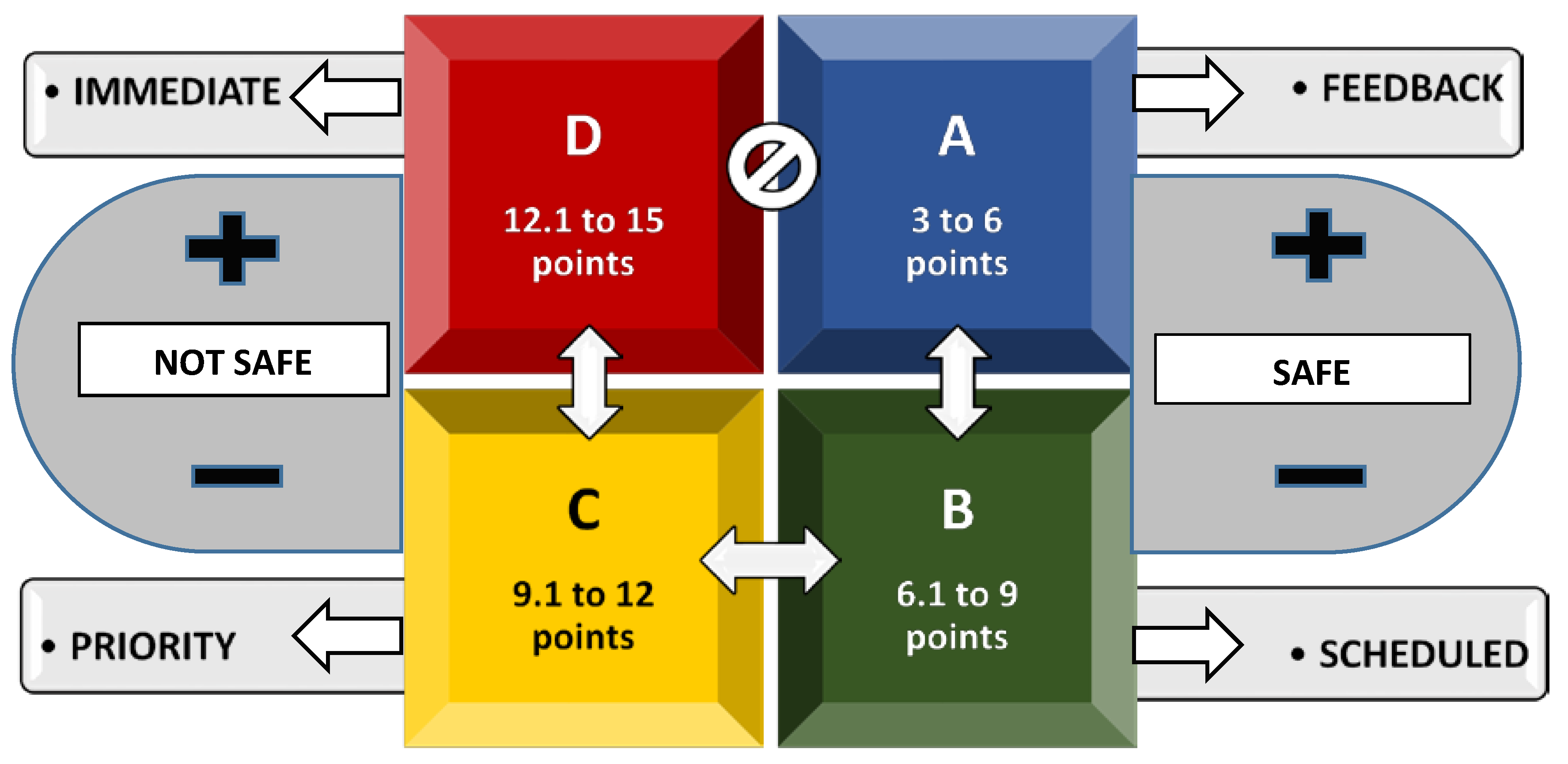
Figure 1. Map of the territory of Araripe UNESCO Global Geopark. Source: Araripe Geopark Database, March 2018; adaptation allowed for this research.
Geosciences 08 00199 g001
Figure 2. A Conceptual Flowchart for Priority Definition of Management Action.
Geosciences 08 00199 g002
Figure 3. Demand of visitors to Araripe UGGp geosites—average of the period from 2016–2017.
Geosciences 08 00199 g003
Table 1. Alphanumeric Reference Legend of the Quadrants.
Geosciences 08 00199 i001B—COLOR: “BLUE” Geosciences 08 00199 i002R—COLOR: “RED”
A—QUADRANTSD—QUADRANTS
6—MAXIMUM SCORE15—MAXIMUM SCORE
S—SAFEN—NOT SAFE
Table 2. Alphanumeric Concept of Quadrant Risk Classification and Management Action.
Geosciences 08 00199 i003FEEDBACKIt is recommended that the conditions found in the area are monitored in order to allow maintenance of the results during the management cycle. Security area (safe).
Geosciences 08 00199 i004SCHEDULEDIndicates a satisfactory relationship between the variables. It is necessary to establish a reasonable period for the intervention of actions that have as a purpose the improvement of the presented indicators.
Security area (safe).
Geosciences 08 00199 i005PRIORITYIndicates a weakened area demonstrated by high impact exposure scores in correlation with the visitation profile. It is recommended that the strategies are reviewed and the resources are reallocated in order to reduce the observed scores. Vulnerable area (not safe).
Geosciences 08 00199 i006IMMEDIATEIndicates a high degree of exposure to impacts in the assessed area. It requires immediate action by the management team and resources, given the occurrences of high scores.
Vulnerable area (not safe).
Table 3. Reference standard and intensity of variables.
ReferenceHighMediumLow
Impacts3 points2 points1 point
Demand3 points2 points1 point
Zone3 points2 points1 point
Management3 points2 points1 point
Table 4. Tabulation of evident impacts on Araripe geosites (PP, Ponte de Pedra; RM, Riacho do Meio; CMV, Cachoeira de Missão Velha; PC, Pedra Cariri; CH, Colina do Horto; PPT, Parque dos Pterossauros; BAT, Batateiras; PON, Pontal de Santa Cruz; FP, Floresta Petrificada).
RankingImpact Occurrence IndicatorPPRMCMVPCCHPPTBATPONFP
1stImproper disposal of waste, residues and spinoffsXXXXXXXXX
2ndDamage to signaling boards and othersXXXXXX--X
3rdDamage to buildings, sculptures and othersXXX-XX-XX
4thGraffiti and depredation in geological heritageXXXXX--X-
5thErosive grooves and changes in soil propertiesXXXXX-X--
6thGeological and geomorphological risksX-XX-X-X-
7thNoise and visual pollutionXXXXX----
8thTrampling, hunting, seizure and risk of extinction of speciesXXX---X--
9thProduction of refuse, waste and spin-offsXX-XX----
10thForest damage and uncontrolled native vegetationXXX-----X
11thPollution and evident discharge in water sources-XX---X--
12thMining, excavation and drillingX--X-X---
13thReports of illegal trade in fossils, historical artifacts and othersX--X-X---
14thUncontrolled redirecting of water sources-X----X--
15thOther (accident report)--X------
TotalNumber of occurrences recorded in geosites121111090706050404
Table 5. Prevalence of evident impacts in Araripe UGGp geosites *.
ReferenceCasesSamplePrevalence (PT %)
Improper disposal of waste, residues and spin-offs99100.0
Damage to signaling boards and others7977.7
Damage to buildings, sculptures and others7977.7
Graffiti and depredation in geological heritage6966.6
Erosive grooves and changes in soil properties6966.6
Geological and geomorphological risks5955.5
Noise and visual pollution5955.5
Trampling, hunting, seizure and risk of extinction of species4944.4
Production of refuse, waste and spin-offs4944.4
Forest damage and uncontrolled native vegetation4944.4
Pollution and evident discharge in water sources3933.3
Mining, excavation and drilling3933.3
Reports of illegal trade of fossils, historical artifacts and others3933.3
Uncontrolled redirecting of water sources2922.2
Other (accident report)1911.1
Table 6. Correlation of the variables in the visitation activity of geosites.
ACTIVITIES OFFEREDIMPDEMZONMAN
Parque dos Pterossauros Geosite
Paleontological Excavations2122
Office and Laboratory1122
Mean1.51.02.02.0
MP = ((1.5 + 2) ÷ 2)2 + ((1 + 2) ÷ 2) + 2 = 6.6
BATATEIRAS GEOSITE
Taipa House1211
Lameiro Waterfall1211
1880 Mill Ruins1211
Ecological Trails1211
Mean1.02.01.01.0
MP = ((1 + 1) ÷ 2)2 + ((2 + 1) ÷ 2) + 1 = 3.5
Cachoeira de Missão Velha Geosite
Waterfall3132
Salgado River Canyon3132
Sedimentary Structures of Sandstones3132
Fonte do Pinga2132
Ichnofossils2132
Casa de Pedra Trail2132
Mean2.51.03.02.0
MP = ((2.5 + 2) ÷ 2)2 + ((2 + 2) ÷ 2) + 3 = 9.6
Colina do Horto Geosite
Chapel of the Holy Sepulcher1311
Religious Services1311
Statue of Priest Cicero2311
Church of the Lord Bom Jesus do Horto1311
Wall of Sedition of 19141311
Priest Cícero Living Museum1311
Regional Restaurant1311
Holly Spulcher Trail1211
Mean1.12.91.01.0
MP = ((1.1 + 1) ÷ 2)2 + ((2.9 + 1) ÷ 2) + 1 = 4.1
Floresta Petrificada Geosite
Rocky Wall1122
Fossil Trunks2122
Mean1.51.02.02.0
MP = ((1.5 + 2) ÷ 2)2 + ((1 + 2) ÷ 2) + 2 = 6.6
Pedra Cariri Geosite
Crato Formation Stratigraphy2122
Cariri Stone Quarries1122
Mean1.51.02.02.0
MP = ((1.5 + 2) ÷ 2)2 + ((1 + 2) ÷ 2) + 2 = 6.6
Pontal de Santa Cruz Geosite
Bom Jesus das Oliveiras Chapel1311
Cross1311
Belvedere1311
Playground1211
Regional Restaurant1311
Pontal Trail2211
Mean1.22.71.01.0
MP = ((1.2 + 1) ÷ 2)2 + ((2.7 + 1) ÷ 2) + 1 = 4.1
Ponte de Pedra Geosite
Geological Stratum3233
Belvedere2233
Mean2.52.03.03.0
MP = ((2.5 + 3) ÷ 2)2 + ((2 + 3) ÷ 2) + 3 = 13.1
Riacho do Meio Geosite
Amphitheater2123
Birdwatching Area2223
Coruja, Meio and Olho d’Água Branco Water Springs3223
Bath Rock1223
Restaurant1223
Ecological Trails2223
Mean1.81.82.03.0
MP = ((1.8 + 3) ÷ 2)2 + ((1.8 + 3) ÷ 2) + 2 = 10.2
IMP—Impact, DEM—Demand, ZON—Zone, MAN—Management, MP—Management Priority.
Table 7. Priority Matrix for Managing Visitation Impacts to Araripe UGGp Geosites.
GEOSITEIMPDEMZONMANMPREFMA
PONTE DE PEDRA2.52.03.03.013.1RD-15NImmediate
RIACHO DO MEIO1.81.82.03.010.2YC-12NPriority
CACHOEIRA DE MISSÃO VELHA2.51.03.02.09.6YC-12NPriority
PARQUE DOS PTEROSSAUROS1.51.02.02.06.6GB-9SScheduled
PEDRA CARIRI1.51.02.02.06.6GB-9SScheduled
FLORESTA PETRIFICADA1.51.02.02.06.6GB-9SScheduled
COLINA DO HORTO1.12.91.01.04.1BA-6SFeedback
PONTAL DE SANTA CRUZ1.22.71.01.04.1BA-6SFeedback
BATATEIRAS1.02.01.01.03.5BA-6SFeedback
IMP—Impact, DEM—Demand, ZON—Zone, MAN—Management, MP—Management Priority, REF—Reference, MA—Management Action. Management Classification (MA): Up to 6 points—“Feedback”, between 6.1 and 9 points—"Scheduled”, between 9.1 and 12 points—“Priority”, at least 12.1 points—“Immediate” (see Figure 2).

