Next Issue
Volume 8, July
Previous Issue
Volume 8, May


Geosciences, Volume 8, Issue 6 (June 2018) – 37 articles

Cover Story (view full-size image): 
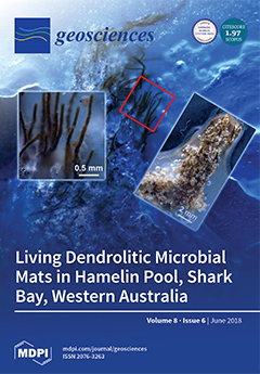
Shrubby microbial structures known as dendrolites are common in the rock record but rare in modern environments. This paper describes living dendrolites that were recently discovered in low energy intertidal settings in Hamelin Pool, Shark Bay. Thick filaments of Lyngbya aestuarii form the “trunks” of the dendrolitic shrubs, with finer filaments of Lyngbya fragilis, Phormidium sp., and Schizothrix sp. forming the “branches.” These modern structures provide insight into our understanding of dendrolite formation throughout the rock record. View Paper here.
  • Issues are regarded as officially published after their release is announced to the table of contents alert mailing list.
  • You may sign up for e-mail alerts to receive table of contents of newly released issues.
  • PDF is the official format for papers published in both, html and pdf forms. To view the papers in pdf format, click on the "PDF Full-text" link, and use the free Adobe Reader to open them.
Order results
Result details
Section
Select all
Export citation of selected articles as:
28 pages, 434 KiB  
Article
A Numerical 1.5D Method for the Rapid Simulation of Geophysical Resistivity Measurements
by Mostafa Shahriari, Sergio Rojas, David Pardo, Angel Rodríguez-Rozas, Shaaban A. Bakr, Victor M. Calo and Ignacio Muga
Geosciences 2018, 8(6), 225; https://doi.org/10.3390/geosciences8060225 - 20 Jun 2018
Cited by 12 | Viewed by 3620
Abstract
In some geological formations, borehole resistivity measurements can be simulated using a sequence of 1D models. By considering a 1D layered media, we can reduce the dimensionality of the problem from 3D to 1.5D via a Hankel transform. The resulting formulation is often [...] Read more.
In some geological formations, borehole resistivity measurements can be simulated using a sequence of 1D models. By considering a 1D layered media, we can reduce the dimensionality of the problem from 3D to 1.5D via a Hankel transform. The resulting formulation is often solved via a semi-analytic method, mainly due to its high performance. However, semi-analytic methods have important limitations such as, for example, their inability to model piecewise linear variations on the resistivity. Herein, we develop a multi-scale finite element method (FEM) to solve the secondary field formulation. This numerical scheme overcomes the limitations of semi-analytic methods while still delivering high performance. We illustrate the performance of the method with numerical synthetic examples based on two symmetric logging-while-drilling (LWD) induction devices operating at 2 MHz and 500 KHz, respectively. Full article
(This article belongs to the Special Issue Petroleum Engineering Applications: Borehole Simulations)
Show Figures

Figure 1

20 pages, 2512 KiB  
Article
Room for Rivers: Risk Reduction by Enhancing the Flood Conveyance Capacity of The Netherlands’ Large Rivers
by Frans Klijn, Nathalie Asselman and Dennis Wagenaar
Geosciences 2018, 8(6), 224; https://doi.org/10.3390/geosciences8060224 - 20 Jun 2018
Cited by 33 | Viewed by 10267
Abstract
The Netherlands has just finished implementing the Room for the Rivers program along the Rhine and Meuse Rivers in response to increasing river discharges. Recently, making more room for the river is, however, being challenged for future application because the flood defenses are [...] Read more.
The Netherlands has just finished implementing the Room for the Rivers program along the Rhine and Meuse Rivers in response to increasing river discharges. Recently, making more room for the river is, however, being challenged for future application because the flood defenses are assessed to be too weak and will need reinforcement anyway. To be able to decide on the most desirable policy for the remainder of the century, we require knowledge of all benefits and costs of individual interventions and strategic alternatives for flood mitigation. In this paper, we quantify some benefits of making more room for the rivers. We recognize and quantify two risk-reducing effects and provide results of analyses for the Rhine and Meuse Rivers in The Netherlands. Making room for rivers was originally advocated because it (1) reduces the consequences of flooding, as well as (2) reduces the probability of failure of the embankments. We have now quantified these effects allowing translation into risk reduction proper. Moreover, larger floodplain surface area may influence the relationship between discharge and flood level, which implies that rivers with widened floodplains are less sensitive to uncertainties about future river discharges. This does not reduce risk proper, but makes the river system more robust, as we shall argue in the discussion where we present risk reduction and robustness as complementary perspectives for assessing strategic alternatives for flood risk management. Full article
(This article belongs to the Special Issue Integrated Risk Analysis and Management of Floods)
Show Figures

Figure 1

30 pages, 16670 KiB  
Article
Non-Mineralized Fossil Wood
by George E. Mustoe
Geosciences 2018, 8(6), 223; https://doi.org/10.3390/geosciences8060223 - 18 Jun 2018
Cited by 25 | Viewed by 15729
Abstract
Under conditions where buried wood is protected from microbial degradation and exposure to oxygen or harsh chemical environments, the tissues may remain unmineralized. If the original organic matter is present in relatively unaltered form, wood is considered to be mummified. Exposure to high [...] Read more.
Under conditions where buried wood is protected from microbial degradation and exposure to oxygen or harsh chemical environments, the tissues may remain unmineralized. If the original organic matter is present in relatively unaltered form, wood is considered to be mummified. Exposure to high temperatures, whether from wild fires or pyroclastic flows, may cause wood to be converted to charcoal. Coalification occurs when plant matter undergoes gradual metamorphosis, producing bituminous alteration products. Examples of all three types of non-mineralized wood are common in the geologic record. This report describes some of the most notable occurrences, reviews past research and introduces data from several localities in North America. Full article
Show Figures

Graphical abstract

19 pages, 4648 KiB  
Article
Potential Indicator Value of Subfossil Gastropods in Assessing the Ecological Health of the Middle and Lower Reaches of the Yangtze River Floodplain System (China)
by Giri Kattel, Yongjiu Cai, Xiangdong Yang, Ke Zhang, Xu Hao, Rong Wang and Xuhui Dong
Geosciences 2018, 8(6), 222; https://doi.org/10.3390/geosciences8060222 - 17 Jun 2018
Cited by 2 | Viewed by 3265
Abstract
The lakes across China’s middle and lower reaches of the Yangtze River system have a long history of sustaining human pressures. These aquatic resources have been exploited for fisheries and irrigation over millennia at a magnitude of scales, with the result that many [...] Read more.
The lakes across China’s middle and lower reaches of the Yangtze River system have a long history of sustaining human pressures. These aquatic resources have been exploited for fisheries and irrigation over millennia at a magnitude of scales, with the result that many lakes have lost their ecological integrity. The consequences of these changes in the ecosystem health of lakes are not fully understood; therefore, a long-term investigation is urgently needed. Gastropods (aquatic snails) are powerful bio-indicators that link primary producers, herbivores, and detritivores associated with macrophytes and grazers of periphyton and higher-level consumers. They are sensitive to abrupt environmental change such as eutrophication, dehydration, flooding, and proliferation of toxicity in floodplain lake systems. The use of the remains of gastropod shells (subfossils) preserved in the sedimentary archives of the floodplain lakes of the middle and lower reaches of the Yangtze River system holds high significance, as their potential in environmental change has not been studied in detail in the past. Here, we aim to test the hypothesis that modern and sub-fossil gastropods in the sediments of the middle and lower reaches of the Yangtze River floodplains systems have significant value as bioindicators, as they have the ability to reveal health-gradients of lake-ecosystem change in the region. Full article
(This article belongs to the Special Issue New Theoretical and Applied Advances in Paleolimnology)
Show Figures

Figure 1

22 pages, 1201 KiB  
Article
Extending INSPIRE to the Internet of Things through SensorThings API
by Alexander Kotsev, Katharina Schleidt, Steve Liang, Hylke Van der Schaaf, Tania Khalafbeigi, Sylvain Grellet, Michael Lutz, Simon Jirka and Mickaël Beaufils
Geosciences 2018, 8(6), 221; https://doi.org/10.3390/geosciences8060221 - 16 Jun 2018
Cited by 26 | Viewed by 6361
Abstract
Spatial Data Infrastructures (SDI) established during the past two decades “unlocked” heterogeneous geospatial datasets. The European Union INSPIRE Directive laid down the foundation of a pan-European SDI where thousands of public sector data providers make their data, including sensor observations, available for cross-border [...] Read more.
Spatial Data Infrastructures (SDI) established during the past two decades “unlocked” heterogeneous geospatial datasets. The European Union INSPIRE Directive laid down the foundation of a pan-European SDI where thousands of public sector data providers make their data, including sensor observations, available for cross-border and cross-domain reuse. At the same time, SDIs should inevitably adopt new technology and standards to remain fit for purpose and address in the best possible way the needs of different stakeholders (government, businesses and citizens). Some of the recurring technical requirements raised by SDI stakeholders include: (i) the need for adoption of RESTful architectures; together with (ii) alternative (to GML) data encodings, such as JavaScript Object Notation (JSON) and binary exchange formats; and (iii) adoption of asynchronous publish–subscribe-based messaging protocols. The newly established OGC standard SensorThings API is particularly interesting to investigate for INSPIRE, as it addresses together all three topics. In this manuscript, we provide our synthesised perspective on the necessary steps for the OGC SensorThings API standard to be considered as a solution that meets the legal obligations stemming out of the INSPIRE Directive. We share our perspective on what should be done concerning: (i) data encoding; and (ii) the use of SensorThings API as a download service. Full article
(This article belongs to the Special Issue Geodata Management)
Show Figures

Figure 1

14 pages, 3796 KiB  
Article
Clay Mineral Suites in Submarine Mud Volcanoes in the Kumano Forearc Basin, Nankai Trough: Constraints on the Origin of Mud Volcano Sediments
by Akira Ijiri, Koichi Iijima, Urumu Tsunogai, Juichiro Ashi and Fumio Inagaki
Geosciences 2018, 8(6), 220; https://doi.org/10.3390/geosciences8060220 - 15 Jun 2018
Cited by 8 | Viewed by 4276
Abstract
Clay mineralogy is an important characteristic of mud volcano sediments. This study determined the clay mineral compositions of sediment from two submarine mud volcanoes in the Kumano forearc basin, Nankai Trough, by X-ray diffraction analysis. Similar compositions dominated by smectite in the two [...] Read more.
Clay mineralogy is an important characteristic of mud volcano sediments. This study determined the clay mineral compositions of sediment from two submarine mud volcanoes in the Kumano forearc basin, Nankai Trough, by X-ray diffraction analysis. Similar compositions dominated by smectite in the two mud volcanoes indicate that the mud volcanoes in the basin are rooted in the same source sequence. These clay mineral compositions differed from those in Pleistocene basin sediment, suggesting that the mud volcano sediment originated beneath the Pleistocene sediment. The illite content in the illite–smectite mixed layer averaged 32% in the mud volcano sediment, which implies that the sediment experienced temperatures above 60 °C that promoted the smectite-to-illite transformation. However, porewater extracted from the mud volcano sediment had Cl concentrations roughly half that of seawater and proportional enrichment in 18O and depletion in D, indicating that dehydration reactions of clay minerals had previously occurred in a deeply buried sedimentary layer. The smectite and illite contents (<60%) in the clay-size fraction rule out in situ smectite dewatering as the cause of the dilution of Cl in porewater. Thus, fluids derived from clay dewatering must have originated from deeper than the source of the mud volcano sediment. Full article
Show Figures

Figure 1

16 pages, 6700 KiB  
Article
Regional Landslide Potential Mapping in Earthquake-Prone Areas of Kepahiang Regency, Bengkulu Province, Indonesia
by Arif Ismul Hadi, Kirbani Sri Brotopuspito, Subagyo Pramumijoyo and Hary Christady Hardiyatmo
Geosciences 2018, 8(6), 219; https://doi.org/10.3390/geosciences8060219 - 15 Jun 2018
Cited by 12 | Viewed by 5322
Abstract
Kepahiang regency is an area above the Musi segment of the Sumatran fault system. This condition makes the study area prone to natural disasters such as landslides in the slope area caused by earthquakes due to tectonic plate movement. The objective of this [...] Read more.
Kepahiang regency is an area above the Musi segment of the Sumatran fault system. This condition makes the study area prone to natural disasters such as landslides in the slope area caused by earthquakes due to tectonic plate movement. The objective of this study was to locate potential landslide areas in earthquake-prone areas of Kepahiang regency, Bengkulu province, Indonesia. We performed horizontal to vertical spectral ratio (HVSR) analysis and simple additive weighting (SAW) methods to accomplish the goal. The acquisition of field data involved a broad band seismometer PASI Gemini-2 (triaxial geophone). The microtremor data recorded in the field were then analyzed by the wave spectrum. The results showed that the landslide potential in the study area could be divided into three categories, i.e., low, medium, and high potential. Areas with high potential should be more aware of the threat of landslides, especially in population-dense areas. The greatest threat in the study area is an earthquake along Sumatra’s active fault. An earthquake that occurs in a very steep, landslide-prone area can increase risk and trigger a landslide. Full article
Show Figures

Figure 1

28 pages, 3737 KiB  
Article
Application of Sensitivity Analysis for Process Model Calibration of Natural Hazards
by Candace Chow, Jorge Ramirez and Margreth Keiler
Geosciences 2018, 8(6), 218; https://doi.org/10.3390/geosciences8060218 - 15 Jun 2018
Cited by 7 | Viewed by 6188
Abstract
Sensitivity analysis (SA) describes how varying inputs to a model subsequently varies its outputs. Its inclusion can support the systematic calibration of numerical models to back-calculate intensity properties of past torrent events that would otherwise be difficult or impossible to collect during their [...] Read more.
Sensitivity analysis (SA) describes how varying inputs to a model subsequently varies its outputs. Its inclusion can support the systematic calibration of numerical models to back-calculate intensity properties of past torrent events that would otherwise be difficult or impossible to collect during their occurrence. Sensitivity analysis for model calibration is assessed with the back-calculation of a known torrent event. In particular, FLO-2D, a cell-based numerical model, is used to simulate the 2005 debris flow event that occurred in Brienz, Switzerland. Under 4000 simulations were completed with ranges of physically reasonable parameter values. Model results were compared in 3-dimensions with both sediment deposition extents (x, y) and estimated deposition heights (z) from available post-event images. The comparisons highlighted that more accurate input and validation data, namely the flow behavior of hazardous processes and post-event deposition heights, are required to produce stronger agreements between simulated and observed results. Furthermore, the application of SA for model calibration supports systematic exploration of large parameter spaces characteristic of complex phenomena like natural hazard events. These findings demonstrated how important model input factors can be identified, which provide guidance for future data collection efforts to capture both the rheology and the spatial distribution of hazards more accurately. Full article
(This article belongs to the Section Natural Hazards)
Show Figures

Figure 1

33 pages, 15218 KiB  
Article
Hybrid GMPEs for Region-Specific PSHA in Southern Italy
by Maria D’Amico, Giovanni Lanzano, Marco Santulin, Rodolfo Puglia, Chiara Felicetta, Mara Monica Tiberti, Antonio Augusto Gomez-Capera and Emiliano Russo
Geosciences 2018, 8(6), 217; https://doi.org/10.3390/geosciences8060217 - 14 Jun 2018
Cited by 2 | Viewed by 3654
Abstract
This paper describes the main findings of the project HYPSTHER (HYbrid ground motion prediction equations for PSha purposes: the study case of souTHERn Italy; supported by the Italian Institute of Geophysics and Volcanology). The goal of the project is to develop a methodological [...] Read more.
This paper describes the main findings of the project HYPSTHER (HYbrid ground motion prediction equations for PSha purposes: the study case of souTHERn Italy; supported by the Italian Institute of Geophysics and Volcanology). The goal of the project is to develop a methodological approach to retrieve hybrid Ground Motion Prediction Equations (GMPEs) based on integration of recorded and synthetic data. This methodology was applied to the study area of southern Italy, focusing on the southern Calabria and Sicily regions. The target area was chosen due to the expected high seismic hazard levels, despite the low seismic activity in recent decades. In addition, along the coast of the study area, there are many critical infrastructures, such as chemical plants, refineries, and large ports, which strongly increase the risk of technological accidents induced by earthquakes. Through the synthetic data, the predictions of the hybrid GMPEs have been improved under near-field conditions, with respect to empirical models for moderate to large earthquakes. Attenuation at distances greater than 50 km is instead controlled by the empirical data, because attenuation is faster with distance. The aleatory variability of the hybrid models has strong impact on probabilistic seismic hazard assessment, as it is lower than the sigma of the empirical GMPEs. The use of the hybrid GMPEs specific for the study area can produce remarkable reductions in hazard levels for long-return periods, mainly due to changes in median predictions and reduction of the aleatory variability. Full article
Show Figures

Figure 1

17 pages, 9642 KiB  
Article
Using ArcticDEM to Analyse the Dimensions and Dynamics of Debris-Covered Glaciers in Kamchatka, Russia
by Iestyn D. Barr, Mikhail D. Dokukin, Ioannis Kougkoulos, Stephen J. Livingstone, Harold Lovell, Jakub Małecki and Anton Y. Muraviev
Geosciences 2018, 8(6), 216; https://doi.org/10.3390/geosciences8060216 - 13 Jun 2018
Cited by 19 | Viewed by 7814
Abstract
On the Kamchatka Peninsula, a number of glaciers are covered by thick volcanic debris, which makes their margins difficult to delineate from satellite imagery. Fortunately, high resolution, multi-temporal digital surface models (DSMs) covering the entire peninsula have recently become freely available (i.e., ArcticDEM). [...] Read more.
On the Kamchatka Peninsula, a number of glaciers are covered by thick volcanic debris, which makes their margins difficult to delineate from satellite imagery. Fortunately, high resolution, multi-temporal digital surface models (DSMs) covering the entire peninsula have recently become freely available (i.e., ArcticDEM). We use these DSMs to analyse the dimensions and dynamics of debris-covered glaciers in the northern Kluchevskoy Volcanic Group, central Kamchatka. This approach demonstrates that between 2012 and 2016, some of the region’s glaciers advanced despite regional and local climate warming. These glacial advances are part of a long-term trend, presumed to reflect the role of extensive supraglacial debris in limiting ice ablation, though there is also evidence for local ice melt due to supraglacial lava/debris flows. Glacier surface velocities during the period 2012–2015 were typically 5–140 m yr−1. Velocities for the major outlets of the region’s central icefield were typically higher than for other extensively debris-covered glaciers globally, likely reflecting the influence of ice supply from the high altitude Ushkovsky caldera. In all, we find ArcticDEM useful for analysing debris-covered glaciers in Kamchatka, providing important information on flow dynamics and terminus change that is difficult to derive from satellite imagery. Full article
(This article belongs to the Special Issue Glacial and Geomorphological Cartography)
Show Figures

Graphical abstract

24 pages, 9177 KiB  
Article
Joint and Lineament Patterns across the Midcontinent Indicate Repeated Reactivation of Basement-Involved Faults
by Caroline M. Burberry, Jerlyn L. Swiatlowski, Mindi L. Searls and Irina Filina
Geosciences 2018, 8(6), 215; https://doi.org/10.3390/geosciences8060215 - 13 Jun 2018
Cited by 3 | Viewed by 4402
Abstract
Joint networks hosted in successively younger rocks, developing as a result of forced (trishear) folding of a rock mass above a deep-seated fault, can be used to infer the reactivation history of that deep-seated fault. This study aims to use joint networks in [...] Read more.
Joint networks hosted in successively younger rocks, developing as a result of forced (trishear) folding of a rock mass above a deep-seated fault, can be used to infer the reactivation history of that deep-seated fault. This study aims to use joint networks in Pennsylvanian, Permian and Cretaceous rocks to document evidence of reactivation on basement faults during the Paleozoic and Mesozoic of Nebraska and Kansas. The most prominent basement features in southeast Nebraska and northeast Kansas are oriented NE-SW, likely related to the Midcontinent Rift System and Nemaha Uplift, and oriented NW-SE, likely related to fabrics from the Central Plains Orogeny. These features are well defined in the potential fields data. Joint patterns in the study area show an E-W oriented trend, as well as clearly discernable NE-SW and subsidiary N-S and NW-SE trends. The E-W trend is interpreted to be related to far-field stresses from Laramide and Ancestral Rocky Mountain orogenic events, whilst the NE-SW trend is interpreted to be related to subtle reactivation on the Mid-continent rift and related faults, observed in basement data. These movements produced stresses of sufficient magnitude to produce joints in the post-rift rock units, but not sufficient to generate shear fractures. Similarly, the ~N-S and NW-SE joint trends are taken as evidence of subtle reactivation on the Nemaha Uplift and Central Plains Orogeny systems, generating joints by the formation of forced folds. This contribution therefore provides a convincing case study of the value of coupled potential fields and surface feature studies in discerning buried tectonic trends and subtle reactivation thereon. Full article
(This article belongs to the Special Issue Tectonics and Morphodynamics)
Show Figures

Figure 1

14 pages, 4283 KiB  
Article
Improved Interpretation of Marine Sedimentary Environments Using Multi-Frequency Multibeam Backscatter Data
by Peter Feldens, Inken Schulze, Svenja Papenmeier, Mischa Schönke and Jens Schneider von Deimling
Geosciences 2018, 8(6), 214; https://doi.org/10.3390/geosciences8060214 - 12 Jun 2018
Cited by 42 | Viewed by 6130
Abstract
Backscatter mosaics based on a multi-frequency multibeam echosounder survey in the continental shelf setting of the North Sea were compared. The uncalibrated backscatter data were recorded with frequencies of 200, 400 and 600 kHz. The results showed that the seafloor appears mostly featureless [...] Read more.
Backscatter mosaics based on a multi-frequency multibeam echosounder survey in the continental shelf setting of the North Sea were compared. The uncalibrated backscatter data were recorded with frequencies of 200, 400 and 600 kHz. The results showed that the seafloor appears mostly featureless in acoustic backscatter mosaics derived from 600 kHz data. The same area surveyed with 200 kHz reveals numerous backscatter anomalies with diameters of 10–70 m deviating between −2 dB and +4 dB from the background sediment. Backscatter anomalies were further subdivided based on their frequency-specific texture and were attributed to bioturbation within the sediment and the presence of polychaetes on the seafloor. While low frequencies show the highest overall contrast between different seafloor types, a consideration of all frequencies permits an improved interpretation of subtle seafloor features. Full article
(This article belongs to the Special Issue Geological Seafloor Mapping)
Show Figures

Figure 1

14 pages, 898 KiB  
Article
A Mathematics Inspired Notation of Scales in the Climate System
by Jörn Behrens
Geosciences 2018, 8(6), 213; https://doi.org/10.3390/geosciences8060213 - 11 Jun 2018
Viewed by 3188
Abstract
Conducting integrated climate research with involvement of such diverse disciplines as mathematics, meteorology, oceanography, economics, geology, biology, social, and communication sciences poses great challenges to the underlying nomenclature and methodology. In this article, we give a definition of the notion of scales, which [...] Read more.
Conducting integrated climate research with involvement of such diverse disciplines as mathematics, meteorology, oceanography, economics, geology, biology, social, and communication sciences poses great challenges to the underlying nomenclature and methodology. In this article, we give a definition of the notion of scales, which is a central term in the geosciences, but not so familiar to social sciences or economics. We start with defining agents, involved in a specific subject of study, determined by their attributes or states. We move on to understand processes and phenomena as maps and subsets of image sets. With this and the introduction of metrics, we can measure sizes of phenomena and processes and finally define scales. Several examples illustrate our definition. An attempt is made to motivate a notion of scale interaction. This concept has proved useful in an interdisciplinary teaching project. Full article
Show Figures

Figure 1

17 pages, 3256 KiB  
Article
Living Dendrolitic Microbial Mats in Hamelin Pool, Shark Bay, Western Australia
by Erica P. Suosaari, Stanley M. Awramik, R. Pamela Reid, John F. Stolz and Kathleen Grey
Geosciences 2018, 8(6), 212; https://doi.org/10.3390/geosciences8060212 - 11 Jun 2018
Cited by 24 | Viewed by 5781
Abstract
Hamelin Pool, Shark Bay, Western Australia, is home to the largest and most diverse assemblage of living marine stromatolites, with shapes and sizes comparable to ancient structures. A recent field-intensive program revealed seasonally ephemeral occurrences of modern dendrolitic microbial mats forming in intertidal, [...] Read more.
Hamelin Pool, Shark Bay, Western Australia, is home to the largest and most diverse assemblage of living marine stromatolites, with shapes and sizes comparable to ancient structures. A recent field-intensive program revealed seasonally ephemeral occurrences of modern dendrolitic microbial mats forming in intertidal, low energy settings. Dominated by filamentous cyanobacteria, dendrolitic microbial mats are formed when filaments provide a supporting framework as a result of gliding mobility, to build a shrubby morphology. Dendrolites, known throughout the rock record, refer to macroscopic microbialites with mesostuctures composed of unlaminated arborescent structures called shrubs. In these modern examples, thick filaments of Lyngbya aestuarii form the “trunk” of the bush, with finer filaments of Lyngbya fragilis, Phormidium sp. and Schizothrix sp. forming the “branches” These biologically-influenced dendrolitic structures provide insight into the complex interplay of microbial communities and the environment, broadening our understanding of shrub and dendrolite formation throughout the rock record. Full article
Show Figures

Figure 1

27 pages, 4237 KiB  
Article
Ancient Microbial Activity in Deep Hydraulically Conductive Fracture Zones within the Forsmark Target Area for Geological Nuclear Waste Disposal, Sweden
by Henrik Drake, Magnus Ivarsson, Mikael Tillberg, Martin J. Whitehouse and Ellen Kooijman
Geosciences 2018, 8(6), 211; https://doi.org/10.3390/geosciences8060211 - 11 Jun 2018
Cited by 19 | Viewed by 4602
Abstract
Recent studies reveal that organisms from all three domains of life—Archaea, Bacteria, and even Eukarya—can thrive under energy-poor, dark, and anoxic conditions at large depths in the fractured crystalline continental crust. There is a need for an increased understanding of the processes and [...] Read more.
Recent studies reveal that organisms from all three domains of life—Archaea, Bacteria, and even Eukarya—can thrive under energy-poor, dark, and anoxic conditions at large depths in the fractured crystalline continental crust. There is a need for an increased understanding of the processes and lifeforms in this vast realm, for example, regarding the spatiotemporal extent and variability of the different processes in the crust. Here, we present a study that set out to detect signs of ancient microbial life in the Forsmark area—the target area for deep geological nuclear waste disposal in Sweden. Stable isotope compositions were determined with high spatial resolution analyses within mineral coatings, and mineralized remains of putative microorganisms were studied in several deep water-conducting fracture zones (down to 663 m depth), from which hydrochemical and gas data exist. Large isotopic variabilities of δ13Ccalcite (−36.2 to +20.2‰ V-PDB) and δ34Spyrite (−11.7 to +37.8‰ V-CDT) disclose discrete periods of methanogenesis, and potentially, anaerobic oxidation of methane and related microbial sulfate reduction at several depth intervals. Dominant calcite–water disequilibrium of δ18O and 87Sr/86Sr precludes abundant recent precipitation. Instead, the mineral coatings largely reflect an ancient archive of episodic microbial processes in the fracture system, which, according to our microscale Rb–Sr dating of co-genetic adularia and calcite, date back to the mid-Paleozoic. Potential Quaternary precipitation exists mainly at ~400 m depth in one of the boreholes, where mineral–water compositions corresponded. Full article
Show Figures

Graphical abstract

17 pages, 2411 KiB  
Article
Reactive and Mixing Processes Governing Ammonium and Nitrate Coexistence in a Polluted Coastal Aquifer
by Chiara Sbarbati, Nicolò Colombani, Micòl Mastrocicco, Marco Petitta and Ramon Aravena
Geosciences 2018, 8(6), 210; https://doi.org/10.3390/geosciences8060210 - 11 Jun 2018
Cited by 13 | Viewed by 3353
Abstract
A comprehensive hydrochemical, stable isotope and microbial analyses characterisation has been performed to evaluate the sources of groundwater, nitrogen pollution and degradation processes occurring in an industrial polluted coastal aquifer in the framework of a complex hydrodynamic system. The coexistence of ammonium and [...] Read more.
A comprehensive hydrochemical, stable isotope and microbial analyses characterisation has been performed to evaluate the sources of groundwater, nitrogen pollution and degradation processes occurring in an industrial polluted coastal aquifer in the framework of a complex hydrodynamic system. The coexistence of ammonium and nitrate has been observed in almost all the investigated monitoring wells, reaching maximum values of 100 and 200 mg/L for both species. Chloride and potassium concentration coupled with groundwater stable isotopes data show the influence of local and urban recharge and the occurrence of seawater intrusion in areas near the coastline. δ15N–NH4+ values ranging between −4.9 and +14.9% suggest that different processes such as partial nitrification of ammonium, probably anammox activities and sorption, are occurring at the site. The isotope data for NH4+ also showed the existence of the remnant of an old fertilizer plume in the downgradient area. The nitrate isotope data ranging between +9 and +46% and +6 and +26% for δ15N–NO3 and δ18O–NO3, respectively, suggest that nitrate content is attenuated by denitrification and probably annamox. The fast groundwater flow field is one of the reasons for the coexistence of NH4+ and NO3 in groundwater, since both compounds can penetrate the reducing zone of the aquifer. The influence of leakage of sewage pipelines on the aquifer cannot be discerned due to the complexities of the nitrogen attenuation processes, also influenced by pumping activities. Full article
(This article belongs to the Special Issue Groundwater Pollution)
Show Figures

Figure 1

15 pages, 5631 KiB  
Article
Numerical Modeling of Remediation Scenarios of a Groundwater Cr(VI) Plume in an Alpine Valley Aquifer
by Gennaro A. Stefania, Marco Rotiroti, Letizia Fumagalli, Chiara Zanotti and Tullia Bonomi
Geosciences 2018, 8(6), 209; https://doi.org/10.3390/geosciences8060209 - 08 Jun 2018
Cited by 14 | Viewed by 4308
Abstract
This work presents the numerical modeling of remediation scenarios aimed at containing and attenuating the groundwater pollution by Cr(VI) sourced from a steelworks area that affects the Alpine aquifer system in the Aosta Plain (N Italy). Here, groundwater is used for drinking water [...] Read more.
This work presents the numerical modeling of remediation scenarios aimed at containing and attenuating the groundwater pollution by Cr(VI) sourced from a steelworks area that affects the Alpine aquifer system in the Aosta Plain (N Italy). Here, groundwater is used for drinking water supply and food and beverage production, so the adoption of remediation works is urgently needed. More specifically, three remediation scenarios were modeled using MODFLOW-2000 and MT3DMS: (a) the activation of a hydraulic barrier to contain the pollution within the source area (Scenario 1); (b) the removal of the pollution sources and the natural attenuation of the residual groundwater plume (Scenario 2); and (c) a combination of the previous two works (Scenario 3). Model results for Scenario 1 showed that a hydraulic barrier composed of five wells located along the eastern border of the steelworks area would contain Cr(VI) concentrations above 5 µg/L (i.e., the Italian regulatory limit) within the steelworks area; the barrier would have a total discharge of 27,500 m3/day, which could be compensated by the deactivation of three steelworks wells; the hydraulic barrier would drop the Cr(VI) concentrations below 5 µg/L in the areas downstream of the steelworks after ~3 years from its start of operation. Results for Scenario 2 highlighted that the removal of the Cr(VI) sources would drop the Cr(VI) concentrations below 5 µg/L in the areas downstream of the steelworks after ~2.5 years, and lead to a full remediation of the Cr(VI) groundwater plume (i.e., total Cr(VI) mass in the aquifer close to zero) after 17 years. Results for Scenario 3 showed that the removal of the Cr(VI) sources accompanied by the activation of the hydraulic barrier would led to a faster remediation within the first 14 years from the starting of the remediation works, with concentrations below 5 µg/L in the areas downstream of the steelworks obtained after ~2.3 years. Full article
(This article belongs to the Special Issue Groundwater Pollution)
Show Figures

Figure 1

24 pages, 10634 KiB  
Article
Geomorphological Mapping and Spatial Analyses of an Upper Weichselian Glacitectonic Complex Based on LiDAR Data, Jasmund Peninsula (NE Rügen), Germany
by Anna Gehrmann and Chris Harding
Geosciences 2018, 8(6), 208; https://doi.org/10.3390/geosciences8060208 - 08 Jun 2018
Cited by 21 | Viewed by 6602
Abstract
Glacitectonic deformation in the Upper Weichselian led to the tectonic framework of large-scale folds and displaced thrust sheets of Maastrichtian (Upper Cretaceous) chalk and Pleistocene glacial deposits in the southwestern Baltic Sea region. They form surface expressions of sub-parallel ridges and elongated valleys [...] Read more.
Glacitectonic deformation in the Upper Weichselian led to the tectonic framework of large-scale folds and displaced thrust sheets of Maastrichtian (Upper Cretaceous) chalk and Pleistocene glacial deposits in the southwestern Baltic Sea region. They form surface expressions of sub-parallel ridges and elongated valleys in between and on the Jasmund Peninsula. Geomorphological mapping and detailed landform analyses give another insight into the arrangement and the formation history of these proglacial surface structures. Light detection and ranging (LiDAR) digital elevation models (DEM) analysis techniques were applied to a proglacial rather than a subglacial environment. Results suggest a division into a northern part with morphological ridges striking NW–SE and a southern part with SW–NE trending ridges. The observation of partly truncated northerly ridges and their superimposition by the southern sub-complex suggest that the northern part was generated earlier than the southern part. The applied spatial analyses tools were used to develop a new, self-consistent genetic model integrating all parts of the 100 km2 large Jasmund Glacitectonic Complex. Results suggest a more consistent terminology for the tectonic setting and a revised genetic model for Jasmund, including three evolutional stages that are characterized by different ice flow patterns. Full article
(This article belongs to the Special Issue Glacial and Geomorphological Cartography)
Show Figures

Graphical abstract

21 pages, 3423 KiB  
Article
GIS and Remote-Sensing Application in Archaeological Site Mapping in the Awsard Area (Morocco)
by Ange Felix Nsanziyera, Hassan Rhinane, Aicha Oujaa and Kenneth Mubea
Geosciences 2018, 8(6), 207; https://doi.org/10.3390/geosciences8060207 - 07 Jun 2018
Cited by 27 | Viewed by 7041
Abstract
Morocco is famous as one of the archaeologically richest places with many sites. In addition, some of the sites have been listed as UNESCO World Human Heritage sites. In situ observations are used in cultural heritage and archaeological sites mapping. However, this procedure [...] Read more.
Morocco is famous as one of the archaeologically richest places with many sites. In addition, some of the sites have been listed as UNESCO World Human Heritage sites. In situ observations are used in cultural heritage and archaeological sites mapping. However, this procedure requires periodic observations, which are practically difficult to combine with traditional methods and practices since this is time consuming and expensive. Thus, modern technologies, mainly GIS and remote sensing, are gaining attention as tools for prediction at archaeological sites. The aim of this paper is to assess the application of GIS and remote sensing in order to develop a predictive model, which will be used in locating areas with high potential as archaeological sites in the Awsard area (southern Morocco). The analytic hierarchy process (AHP) as a multi-criteria decision making method, which integrates archaeological data and environmental factors, geospatial analysis and predictive modelling, has been applied to the identification of possible tumuli locations in the study area. The model was developed using a zone of 21 km2 with 233 known sites. It was later validated using 530 unknown sites within an area of 980 km2. The acceptable accuracy of 93% was calculated using an estimation of predictive gain, which proves the efficiency of the model’s predictive ability. Full article
Show Figures

Figure 1

17 pages, 3814 KiB  
Article
Albedo of a Small Ice-Covered Boreal Lake: Daily, Meso-Scale and Interannual Variability on the Background of Regional Climate
by Galina Zdorovennova, Nikolay Palshin, Tatyana Efremova, Roman Zdorovennov, Galina Gavrilenko, Sergey Volkov, Sergey Bogdanov and Arkady Terzhevik
Geosciences 2018, 8(6), 206; https://doi.org/10.3390/geosciences8060206 - 07 Jun 2018
Cited by 4 | Viewed by 4914
Abstract
In winter, the reflective properties of ice-and-snow-covered lakes and the surrounding surface covered with snow differ little. Estimation of the albedo becomes especially important in spring when the reflectivity of the ice-covered lakes differs markedly from the surrounding snow-free surface. The measurements of [...] Read more.
In winter, the reflective properties of ice-and-snow-covered lakes and the surrounding surface covered with snow differ little. Estimation of the albedo becomes especially important in spring when the reflectivity of the ice-covered lakes differs markedly from the surrounding snow-free surface. The measurements of the snow and ice albedo in situ are necessary to ensure adequate analysis of remote sensing data and monitoring of the state of the land ice. A wide range of surface albedo of small boreal ice-covered Lake Vendyurskoe (North-Western Russia) is calculated from observational data of solar radiation obtained in 1995–2000 and 2002–2017. A noticeable variability of albedo due to spring melting and changes in weather conditions is described. Climatic variability (North Atlantic Oscillation (NAO) index, the average monthly air temperature and sum of precipitation in December-March) is analyzed in the context of possible influence on the maximal thickness of snow and white ice, and, consequently, on the spring lake albedo dynamics. In current work to estimate the external heat flux that comes from the atmosphere to the surface of the lake and presumably determines the dynamics of albedo during spring melting, a simple parameter was used: the accumulated sum of positive temperatures, starting from March 1. The obtained prognostic equation of the cubic dependence of albedo on the named parameter demonstrates a different rate of albedo decrease in the melting of snow, white, and congelation ice. Full article
Show Figures

Figure 1

18 pages, 2800 KiB  
Article
Geotourism and Local Development Based on Geological and Mining Sites Utilization, Zaruma-Portovelo, Ecuador
by Paúl Carrión Mero, Gricelda Herrera Franco, Josué Briones, Pablo Caldevilla, María José Domínguez-Cuesta and Edgar Berrezueta
Geosciences 2018, 8(6), 205; https://doi.org/10.3390/geosciences8060205 - 06 Jun 2018
Cited by 67 | Viewed by 8115
Abstract
This study offers a detailed assessment of the geosites and mining sites present in the Zaruma-Portovelo mining district (Ecuador) through their qualitative and quantitative assessment. It shows up the potentiality of this area taking advantage of its geological-mining heritage. The methodological process includes: [...] Read more.
This study offers a detailed assessment of the geosites and mining sites present in the Zaruma-Portovelo mining district (Ecuador) through their qualitative and quantitative assessment. It shows up the potentiality of this area taking advantage of its geological-mining heritage. The methodological process includes: (i) compilation and inventory of all the sites within the study area with particular geological or mining interest; (ii) preparation of reports and thematic cartography, (iii) assessment and classification of the elements of geological-mining interest; (iv) SWOT (Strengths, Weaknesses, Opportunities, Threats) analysis and TOWS (Threats, Opportunities, Weaknesses, Strengths) matrix preparation seeking strategies to guarantee the viability of geotourism. A total of 16 sites of geological interest and 11 of mining interest were identified. The 77% of these sites was proved to be of high and very high interest in scientific terms. Likewise, their susceptibility to degradation assessed from their vulnerability and fragility was found to be high or very high in the 30% of the cases. As for the protection priority, all the studied sites obtained a medium-high result. Finally, the study based on the SWOT-TOWS revealed the possibility of applying action strategies in order to facilitate the compatibility of geotourism with the current productive activities, despite the difficult situation in the study area created by mining activities. Full article
(This article belongs to the Special Issue Geotourism)
Show Figures

Graphical abstract

17 pages, 4183 KiB  
Article
Migration and Morphology of Asymmetric Barchans in the Central Hexi Corridor of Northwest China
by Zhengcai Zhang, Zhibao Dong, Guangyin Hu and Eric J. R. Parteli
Geosciences 2018, 8(6), 204; https://doi.org/10.3390/geosciences8060204 - 06 Jun 2018
Cited by 23 | Viewed by 6522
Abstract
Crescent-shaped barchan dunes often display an asymmetric shape, with one limb longer than the other. As shown in previous studies, asymmetric bimodal winds constitute one major cause of barchan asymmetry, but the heterogeneous conditions of sand availability or flux, as well as topographic [...] Read more.
Crescent-shaped barchan dunes often display an asymmetric shape, with one limb longer than the other. As shown in previous studies, asymmetric bimodal winds constitute one major cause of barchan asymmetry, but the heterogeneous conditions of sand availability or flux, as well as topographic influences, may be also important. Understanding the morphology and dynamics of asymmetric barchans may have an impact in a broad range of areas, particularly as these dunes may serve as a proxy for planetary wind regimes and soil conditions in extraterrestrial environments. However, in addition to the existing theories and numerical models that explain barchan asymmetry, direct measurements of migration rates and morphologic changes of real asymmetric barchans over a time span of several years would be beneficial. Therefore, here we report such measurements, which we have acquired by investigating asymmetric barchans in the Hexi Corridor, northwest of China. We have found that dune interactions and asymmetric influx conditions are the most important causes of barchan asymmetry in this field. Particle size distributions in the Hexi Corridor display strong variations over different parts of the asymmetric barchans, as well as over different dunes, with gravel particles being incorporated from the substrate as the dunes migrate. Our observations have shown that upwind sediment sources are important for dune formation in the Hexi Corridor, and that interdune interactions affect dune shape in different ways, depending on their offset. The asymmetric barchans in the Hexi Corridor are active, with an average migration rate (MR) between 8 and 53 m year−1, in spite of the different asymmetric shapes. Our data for dune migration rates can be described well by a scaling of MR = A/(W + W0), where W is the barchan cross-wind width, A ≈ 2835 m2 s−1, and W0 ≈ 44 m. A similar scaling fits very well the migration rate as a function of dune along-wind width L, (i.e., MR = B/(L + L0), with B ≈ 1722 m2 s−1 and L0 ≈ 13 m). Linear relations are also found between both dune widths and the average limb and windward side lengths, thus indicating that the morphometric relations that are predicted from models for steady-state, symmetric crescent-shaped dunes can be applied to different transitional morphologies of interacting, asymmetric barchans. Full article
(This article belongs to the Special Issue Aeolian Processes and Geomorphology)
Show Figures

Figure 1

35 pages, 8670 KiB  
Article
Response of Soils and Soil Ecosystems to the Pennsylvanian–Permian Climate Transition in the Upper Fluvial Plain of the Dunkard Basin, Southeastern Ohio, USA
by Daniel I. Hembree and Jennifer L. Carnes
Geosciences 2018, 8(6), 203; https://doi.org/10.3390/geosciences8060203 - 05 Jun 2018
Cited by 5 | Viewed by 3690
Abstract
Direct exposure of paleosols to the atmosphere during formation make them ideal for reconstructing paleoclimate. Paleosol and ichnofossil properties are dependently linked making it important to study them in tandem, to avoid errors in interpretation. Small scale studies (<1 km) yield high resolution [...] Read more.
Direct exposure of paleosols to the atmosphere during formation make them ideal for reconstructing paleoclimate. Paleosol and ichnofossil properties are dependently linked making it important to study them in tandem, to avoid errors in interpretation. Small scale studies (<1 km) yield high resolution data that can be used to assess allogenic processes through comparison of spatial and temporal trends. This study used field and laboratory analyses to gather data from Late Pennsylvanian to Early Permian Upper Monongahela and Lower Dunkard group paleosols on Ohio Route 33 in Meigs County, OH, USA. The physical and geochemical properties of the paleosols from the field sites indicate that channel migration was the primary control on paleosol formation in the study area, however, a clear climate signal was observed. The change in paleosol type and calculated mean annual precipitation (MAP) values indicate that the climate became more strongly seasonal and drier over the course of the Pennsylvanian–Permian transition with a temporary excursion to a more ever-wet climate with higher MAP, marked by the occurrence of the Waynesburg Coal at the Pennsylvanian–Permian boundary. Full article
(This article belongs to the Section Biogeosciences)
Show Figures

Figure 1

16 pages, 1779 KiB  
Article
Preliminary Data Validation and Reconstruction of Temperature and Precipitation in Central Italy
by Matteo Gentilucci, Maurizio Barbieri, Peter Burt and Fabrizio D’Aprile
Geosciences 2018, 8(6), 202; https://doi.org/10.3390/geosciences8060202 - 03 Jun 2018
Cited by 34 | Viewed by 4681
Abstract
This study provides a unique procedure for validating and reconstructing temperature and precipitation data. Although developed from data in Middle Italy, the validation method is intended to be universal, subject to appropriate calibration according to the climate zones analysed. This research is an [...] Read more.
This study provides a unique procedure for validating and reconstructing temperature and precipitation data. Although developed from data in Middle Italy, the validation method is intended to be universal, subject to appropriate calibration according to the climate zones analysed. This research is an attempt to create shared applicative procedures that are most of the time only theorized or included in some software without a clear definition of the methods. The purpose is to detect most types of errors according to the procedures for data validation prescribed by the World Meteorological Organization, defining practical operations for each of the five types of data controls: gross error checking, internal consistency check, tolerance test, temporal consistency, and spatial consistency. Temperature and precipitation data over the period 1931–2014 were investigated. The outcomes of this process have led to the removal of 375 records (0.02%) of temperature data from 40 weather stations and 1286 records (1.67%) of precipitation data from 118 weather stations, and 171 data points reconstructed. In conclusion, this work contributes to the development of standardized methodologies to validate climate data and provides an innovative procedure to reconstruct missing data in the absence of reliable reference time series. Full article
Show Figures

Figure 1

21 pages, 1121 KiB  
Article
Global Warming Can Lead to Depletion of Oxygen by Disrupting Phytoplankton Photosynthesis: A Mathematical Modelling Approach
by Yadigar Sekerci and Sergei Petrovskii
Geosciences 2018, 8(6), 201; https://doi.org/10.3390/geosciences8060201 - 03 Jun 2018
Cited by 25 | Viewed by 10556
Abstract
We consider the effect of global warming on the coupled plankton-oxygen dynamics in the ocean. The net oxygen production by phytoplankton is known to depend on the water temperature and hence can be disrupted by warming. We address this issue theoretically by considering [...] Read more.
We consider the effect of global warming on the coupled plankton-oxygen dynamics in the ocean. The net oxygen production by phytoplankton is known to depend on the water temperature and hence can be disrupted by warming. We address this issue theoretically by considering a mathematical model of the plankton-oxygen system. The model is generic and can account for a variety of biological factors. We first show that sustainable oxygen production by phytoplankton is only possible if the net production rate is above a certain critical value. This result appears to be robust to the details of model parametrization. We then show that, once the effect of zooplankton is taken into account (which consume oxygen and feed on phytoplankton), the plankton-oxygen system can only be stable if the net oxygen production rate is within a certain intermediate range (i.e., not too low and not too high). Correspondingly, we conclude that a sufficiently large increase in the water temperature is likely to push the system out of the safe range, which may result in ocean anoxia and even a global oxygen depletion. We then generalize the model by taking into account the effect of environmental stochasticity and show that, paradoxically, the probability of oxygen depletion may decrease with an increase in the rate of global warming. Full article
Show Figures

Figure 1

15 pages, 7454 KiB  
Article
Moho Depth and Crustal Architecture Beneath the Levant Basin from Global Gravity Field Model
by Daniele Sampietro, Ahmed Hamdi Mansi and Martina Capponi
Geosciences 2018, 8(6), 200; https://doi.org/10.3390/geosciences8060200 - 02 Jun 2018
Cited by 16 | Viewed by 6791
Abstract
The study of the discontinuity between the Earth crust and upper mantle, the so-called Moho, and of the lithospheric architecture in general, has several important applications in exploration geophysics. For instance, it is used to facilitate the inversion of seismic-related data, in order [...] Read more.
The study of the discontinuity between the Earth crust and upper mantle, the so-called Moho, and of the lithospheric architecture in general, has several important applications in exploration geophysics. For instance, it is used to facilitate the inversion of seismic-related data, in order to obtain important information on the sedimentary layers or to study the Earth’s heat flux. In this paper, the Levant crustal structure is being investigated starting from the inversion of gravity disturbances coming from a global geopotential field model based on ESA GOCE satellite mission integrated with seismic derived information. In the considered area, which is of particular interest because of its richness from the resources point of view, the deep crustal structure is still a matter of study due to the presence of a thick sequence of sedimentary layers, deposited within geological eras by the Nile River. Within the current work, the shape of the Oceanic domain in correspondence to the Herodotus Basin and the Cyprus Arc has been clearly defined. Moreover the nature of the Levantine Basin and of the Eratosthenes crust has been investigated by a set of ad hoc tests, finding the presence of continental crust. Finally, the Moho depth and the crustal density distribution have been retrieved. Several localized anomalies, in the Cyprus area, have been identified and modelled too, thus confirming the presence of heavy material, with a thickness up to 10 km, in the sedimentary layer and shallower part of the crust. Full article
(This article belongs to the Special Issue Numerical Methods of Geophysical Fields Inversion)
Show Figures

Graphical abstract

21 pages, 2686 KiB  
Article
Matrix of Priorities for the Management of Visitation Impacts on the Geosites of Araripe UNESCO Global Geopark (NE Brazil)
by Eduardo S. Guimarães, Artur Sá, Ronaldo Gabriel, Helena Moreira, Jaqueliny R. S. Guimarães, Paulo Felipe R. Bandeira, João Marcos F. de Lima Silva, Rafael C. Soares and José Patrício P. Melo
Geosciences 2018, 8(6), 199; https://doi.org/10.3390/geosciences8060199 - 01 Jun 2018
Cited by 7 | Viewed by 6695
Abstract
In order to safeguard the material and immaterial heritage and to foster delightful experiences for visitors, this investigation aimed to define a Matrix of Priorities for management of Visitation Impacts Management on the Geosites of Araripe UNESCO Global Geopark. With a quantitative approach [...] Read more.
In order to safeguard the material and immaterial heritage and to foster delightful experiences for visitors, this investigation aimed to define a Matrix of Priorities for management of Visitation Impacts Management on the Geosites of Araripe UNESCO Global Geopark. With a quantitative approach involving the revision of documents, the methods used in this paper determined what the demands for visitation are as well as the impacts of these demands. We identified the offers for activities and occurrences in the geosites. Using this model, we calculated the following variables: (i) evident impacts, (ii) management profile, (iii) visitor demand and (iv) activity zone. We also classified the recommended management actions and presented the priority matrix. We classified the geosites of Ponte de Pedra, Riacho do Meio and Cachoeira de Missão Velha as requiring immediate or priority management action, in view of the high impacts of visitation evidenced. The geosites of Pedra Cariri, Floresta Petrificada and Parque dos Pterossauros were classified as programmed action, highlighting the difficulty of accessing them and the low demand for visitation. The geosites Pontal de Santa Cruz, Colina do Horto and Batateiras presented the best scores and require feedback action. It is emphasized that the deepening the investigations is required in order to produce and interpret the data complexity that guides the management of a dynamic territory such as a UNESCO Global Geopark. Full article
(This article belongs to the Special Issue Selected Papers from the “14th European Geoparks Conference”)
Show Figures

Figure 1

19 pages, 2135 KiB  
Review
Volcanic Plume Impact on the Atmosphere and Climate: O- and S-Isotope Insight into Sulfate Aerosol Formation
by Erwan Martin
Geosciences 2018, 8(6), 198; https://doi.org/10.3390/geosciences8060198 - 31 May 2018
Cited by 12 | Viewed by 5801
Abstract
The impact of volcanic eruptions on the climate has been studied over the last decades and the role played by sulfate aerosols appears to be major. S-bearing volcanic gases are oxidized in the atmosphere into sulfate aerosols that disturb the radiative balance on [...] Read more.
The impact of volcanic eruptions on the climate has been studied over the last decades and the role played by sulfate aerosols appears to be major. S-bearing volcanic gases are oxidized in the atmosphere into sulfate aerosols that disturb the radiative balance on earth at regional to global scales. This paper discusses the use of the oxygen and sulfur multi-isotope systematics on volcanic sulfates to understand their formation and fate in more or less diluted volcanic plumes. The study of volcanic aerosols collected from air sampling and ash deposits at different distances from the volcanic systems (from volcanic vents to the Earth poles) is discussed. It appears possible to distinguish between the different S-bearing oxidation pathways to generate volcanic sulfate aerosols whether the oxidation occurs in magmatic, tropospheric, or stratospheric conditions. This multi-isotopic approach represents an additional constraint on atmospheric and climatic models and it shows how sulfates from volcanic deposits could represent a large and under-exploited archive that, over time, have recorded atmospheric conditions on human to geological timescales. Full article
Show Figures

Figure 1

9 pages, 571 KiB  
Communication
Geodiversity Research Methods in Geotourism
by Magdalena Kuleta
Geosciences 2018, 8(6), 197; https://doi.org/10.3390/geosciences8060197 - 31 May 2018
Cited by 14 | Viewed by 4068
Abstract
With the emerging new approaches in the field of geodiversity, we can get better use of geographic space in geoparks and increase the number of geotourism destinations. Depending on what we want to study in geodiversity, a suitable research method should be adopted. [...] Read more.
With the emerging new approaches in the field of geodiversity, we can get better use of geographic space in geoparks and increase the number of geotourism destinations. Depending on what we want to study in geodiversity, a suitable research method should be adopted. No method is wrong, because various features of objects be examined this manner. In this study, the main objective is to identify and present not only quantitative but also qualitative character of geodiversity issue. Qualitative and quantitative features of objects based on appropriate categorization and their reference to scales, are to designate areas suitable for sustainable geotourism. It is important to develop a methodological approach in line with the chosen objective. The following material is a presentation of the most frequently used methods in the geodiversity of their purposes and use in geotourism. Full article
(This article belongs to the Special Issue Selected Papers from the “14th European Geoparks Conference”)
Show Figures

Figure 1

30 pages, 19962 KiB  
Article
Modelling Individual Evacuation Decisions during Natural Disasters: A Case Study of Volcanic Crisis in Merapi, Indonesia
by Jumadi, Alison J. Heppenstall, Nick S. Malleson, Steve J. Carver, Duncan J. Quincey and Vern R. Manville
Geosciences 2018, 8(6), 196; https://doi.org/10.3390/geosciences8060196 - 30 May 2018
Cited by 23 | Viewed by 6995
Abstract
As the size of human populations increases, so does the severity of the impacts of natural disasters. This is partly because more people are now occupying areas which are susceptible to hazardous natural events, hence, evacuation is needed when such events occur. Evacuation [...] Read more.
As the size of human populations increases, so does the severity of the impacts of natural disasters. This is partly because more people are now occupying areas which are susceptible to hazardous natural events, hence, evacuation is needed when such events occur. Evacuation can be the most important action to minimise the impact of any disaster, but in many cases there are always people who are reluctant to leave. This paper describes an agent-based model (ABM) of evacuation decisions, focusing on the emergence of reluctant people in times of crisis and using Merapi, Indonesia as a case study. The individual evacuation decision model is influenced by several factors formulated from a literature review and survey. We categorised the factors influencing evacuation decisions into two opposing forces, namely, the driving factors to leave (evacuate) versus those to stay, to formulate the model. The evacuation decision (to stay/leave) of an agent is based on an evaluation of the strength of these driving factors using threshold-based rules. This ABM was utilised with a synthetic population from census microdata, in which everyone is characterised by the decision rule. Three scenarios with varying parameters are examined to calibrate the model. Validations were conducted using a retrodictive approach by performing spatial and temporal comparisons between the outputs of simulation and the real data. We present the results of the simulations and discuss the outcomes to conclude with the most plausible scenario. Full article
(This article belongs to the Special Issue Volcano Monitoring – Placing the Finger on the Pulse)
Show Figures

Figure 1

Previous Issue
Next Issue
Back to TopTop